Introduction
In north-western China, as in many other parts of the world, archaeological materials and the people who made them have been classified into cultures based on stylistic similarities in artefact assemblages (Wang Reference Wang2012). In turn, these designations have been used to delineate the geographic and chronological continuity of groups who used these objects. Particular attention has been paid to changes in the form and surface treatment of pottery vessels, as these artefacts are often both abundant and relatively easy to classify typologically (Rice Reference Rice and Van Der Leeuw1984). While classification based on artefact types can be a useful method for organising data, issues can occur when artefacts are used uncritically as proxies for social groups. It is problematic, for instance, when abrupt changes in the form and surface treatment of pottery are taken to reflect major social change, as it has been demonstrated ethnographically that shifts in vessel form and surface treatment can occur in a relatively superficial manner; for example, through the copying of designs from neighbouring groups (Gosselain Reference Gosselain2000, Reference Gosselain, Stark, Bowser, Horne and Longacre2008). While adopting new designs may reflect changes in real or desired relationships between groups, it may alternatively indicate little more than a shared aesthetic appeal (Gosselain Reference Gosselain2000, Reference Gosselain, Stark, Bowser, Horne and Longacre2008). When inferring connections between shifts in ceramic production and wider social change, it is therefore important to consider other aspects of ceramics that are less susceptible to copying, such as underlying clay recipes and forming techniques (Roux & Courty Reference Roux and Courty2013).
Integral to this is an understanding of how knowledge of ceramic production is passed on through a community of practice (Minar & Crown Reference Minar and Crown2001; Sassaman & Rudolphi Reference Sassaman and Rudolphi2001; Stark Reference Stark, Habicht-Mauche, Eckert and Huntley2006)—defined here as a group of closely related producers who share and hand down knowledge about production and specific motor skills over time. As several studies have shown, production techniques are generally resistant to change when being passed on within a single community of practice (Rice Reference Rice and Van Der Leeuw1984; Crown Reference Crown2001). While the process of learning how to produce pottery varies significantly between groups, hands-on-learning—which is frequently observed ethnographically—often results in the conservative reproduction of production techniques (Minar & Crown Reference Minar and Crown2001; Wallaert-Pêtre Reference Wallaert-Pêtre2001; Bowser & Patton Reference Bowser, Patton, Stark, Bowser, Horne and Longacre2008). Selection of clay and raw materials may be taught verbally and through participation in resource gathering, but adding temper and preparing clay are motor skills that are often transmitted through hands-on repetition of these steps. Attempting to connect changes in ceramics with large-scale social changes, therefore, should ideally involve analysis of all production steps, including clay recipes and vessel-forming and -finishing techniques. This would also identify whether discontinuities in production practices coincide with changes in form and decoration.
Understanding continuity and change in each aspect of ceramic production is particularly important in areas of the world where stylistic changes in ceramics have been hypothesised to reflect significant social change. In north-western China, the transition from Majiayao- (马家窑) (3200–2000 BC) to Qijia- (齐家) (2300–1500 BC) style ceramics has been interpreted in precisely this manner. In this case, the shift from the large, painted pottery of the Majiayao to the smaller, mostly plain pottery of the Qijia is explained as a reflection of climate-change-induced migrations, including a potential shift towards a more pastoral way of life (An et al. Reference An, Tang, Barton and Chen2005; Liu et al. Reference Liu, Zhang, Feng, Hou, Zhou and Zhang2010; Cui et al. Reference Cui, Dong, Li, An, Liu, Wang, Wang, Ren, Li and Chen2015). Very little research, however, has focused on the production of Majiayao pottery and even less on Qijia materials (Li Reference Li2005; Hung Reference Hung2011; Cui et al. Reference Cui, Dong, Li, An, Liu, Wang, Wang, Ren, Li and Chen2015). Thus, the relationship between shifts in production practices, pottery form and surface treatments, and social changes such as proposed migrations, remains unexplored.
This study builds on a growing corpus of data from around the world, which demonstrates the importance of examining production techniques and communities of practice when exploring connections between shifts in ceramic style and social change. Studies by D'Ercole et al. (Reference D'Ercole, Budka, Sterba, Garcea and Mader2017) and Ting (Reference Ting2017) show that knowledge of underlying production techniques and paste recipes allows for a nuanced examination of the impact of external influences or shifts in social organisation on pottery style and production. These case studies, along with the work presented here, should encourage researchers to consider more carefully exactly what changes in ceramic form and decoration reflect—particularly in cases where such changes are not mirrored by underlying shifts in production practices.
The Late Neolithic Tao River Valley
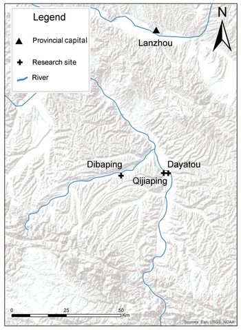
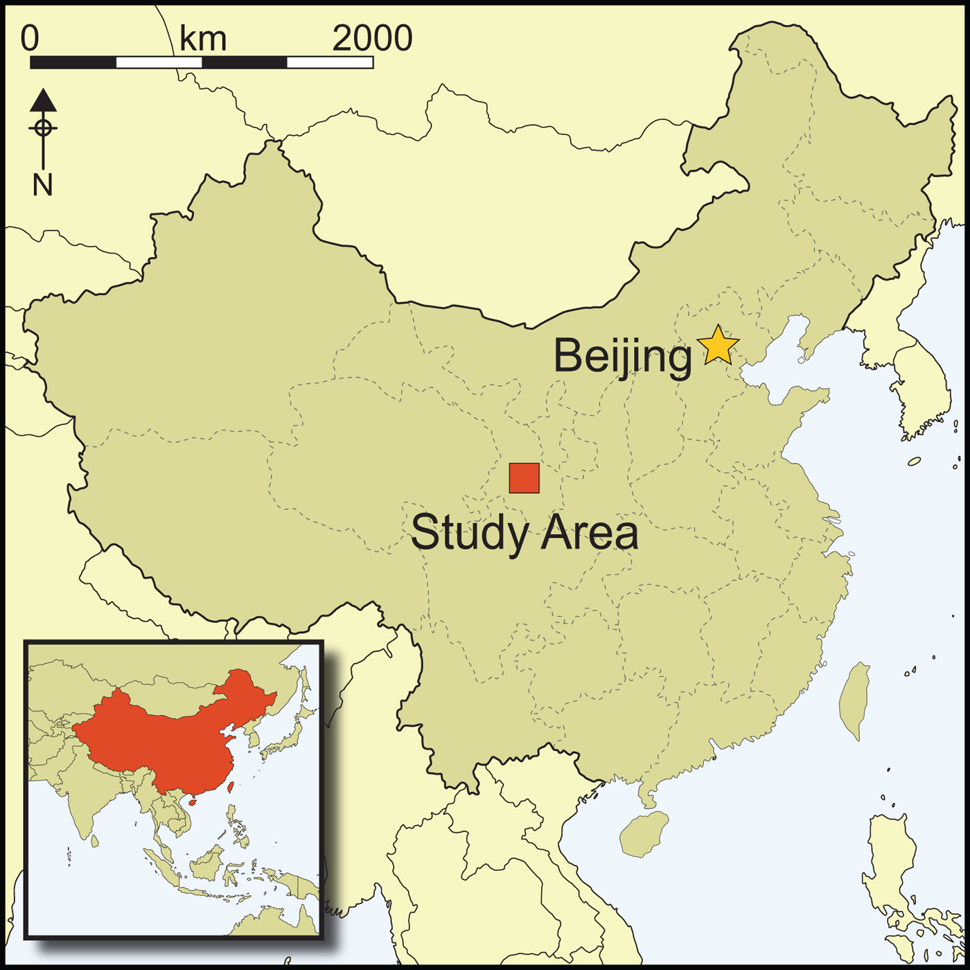
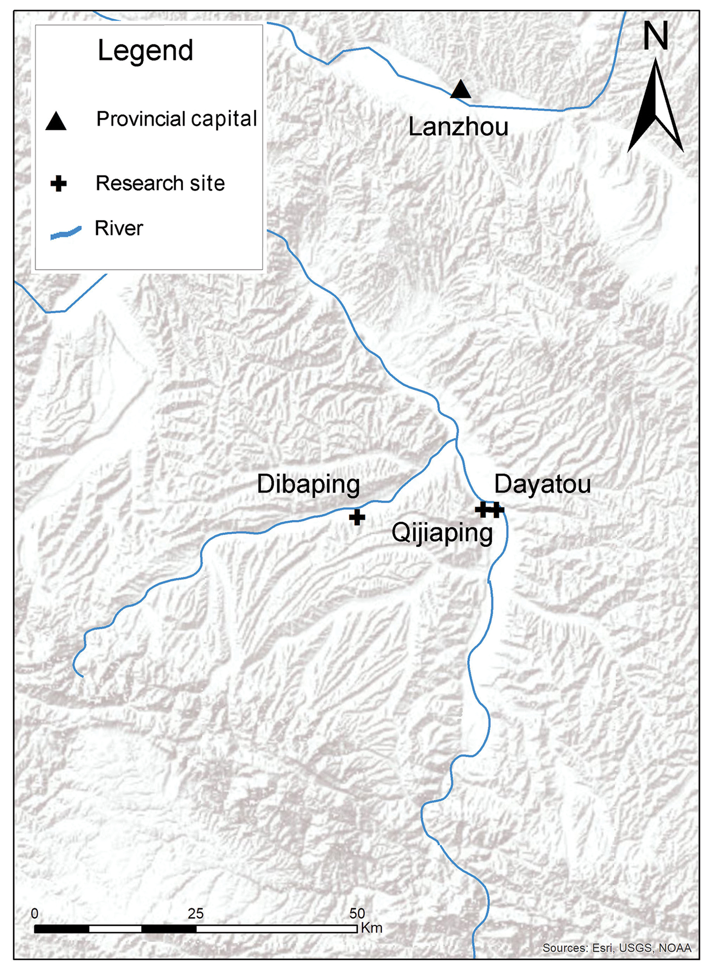
This research focuses on three Majiayao- and Qijia-period sites located in the northern Tao River Valley of southern Gansu Province (Figure 1). Here, Majiayao and Qijia will be used to refer to groups who inhabited this region from 3200–2000 BC and 2300–1500 BC, respectively, and who used pottery associated with sites from these periods. The local landscape comprises large hills formed from wind-blown loess, which overlies a layer of tertiary red clay that outcrops throughout the river valley (Liu et al. Reference Liu, An, Rolph, Qiang, Hesse, Lu, Zhou and Cai2001). The geologist J.G. Andersson and his colleagues from the Geological Survey of China first identified archaeological sites in the region in the 1920s (Andersson Reference Andersson1925; Fiskesjö & Chen Reference Fiskesjö and Chen2004). Since then, hundreds of sites dating from the Neolithic through to historical times have been identified in the valley. Several site surveys and excavations have been undertaken over the years (Zhongguo 2011), with a particular focus on Majiayao- and Qijia-period mortuary contexts. Until recently, however, habitation sites in the valley have rarely been excavated systematically.
A map indicating the location of the three sites investigated for this study (map by A. Womack).
The results of previous research on local mortuary sites, and from a small number of excavations of habitation sites in other parts of Gansu and Qinghai, appear to show that during both periods, settlements consisted primarily of small villages containing a few dozen semi-subterranean houses, along with storage and refuse pits (Hung Reference Hung2011; Chen Reference Chen and Underhill2013). The few known examples of pottery kilns typically appear alongside houses, although in one early Majiayao-period site, pottery kilns and pottery production tools were found clustered together, without any associated evidence for habitation (Gansusheng 1957). Some, but not all, cemeteries were located near habitation areas (Hung Reference Hung2011; Chen Reference Chen and Underhill2013). Subsistence was based on a mixture of farming crops, primarily millet, with wheat and barley becoming increasingly important at some sites during the later Qijia period (Li et al. Reference Li, Dodson, Zhou, Zhang and Masutomoto2007, Reference Li, Yang, Wang, Wang, Jia and Ge2010, Reference Li, Yang, Ge, Ren and Wan2013). Domesticated animals primarily comprise pigs and dogs at Majiayao-period sites, with increasing quantities of sheep, goats and cattle appearing at some Qijia-period sites (Liu & Chen Reference Liu and Chen2012).
This shift in subsistence practices is seen as part of a wider trend, beginning in the Majiayao period and expanding in the Qijia period, of the adoption from Central Asia of new domesticates and technologies, including metal-working (An Reference An1981; Debaine-Francfort Reference Debaine-Francfort1995; Fitzgerald-Huber Reference Fitzgerald-Huber1995). Qijia-period peoples in particular are considered to have played a key role in transmitting these plants, animals and technologies farther to the east, where they would go on to have a significant influence on the development of early Chinese civilisation in the northern Central Plain (Liu & Chen Reference Liu and Chen2012; Yi Reference Yi2014). Majiayao- and Qijia-period peoples are also considered a conduit for domesticates, such as millet and rice, and technologies, such as jade carving, which were moving in the opposite direction (Fuller Reference Fuller2011; Miller et al. Reference Miller, Spengler and Frachetti2016; Jaffe & Flad Reference Jaffe, Flad, Boivin and Frachetti2018). Despite the hypothesised impact that these Central Asian connections may have had on the Majiayao and Qijia peoples of the Tao River Valley, surprisingly little is known about the relationship between these new technologies and proposed shifts in ceramics or social organisation. Investigating what changes in pottery may actually reflect is, therefore, a critical step in the larger process of understanding the impact of new technologies and contacts on the societies of the Tao River Valley and beyond.
Previous research and macro analysis
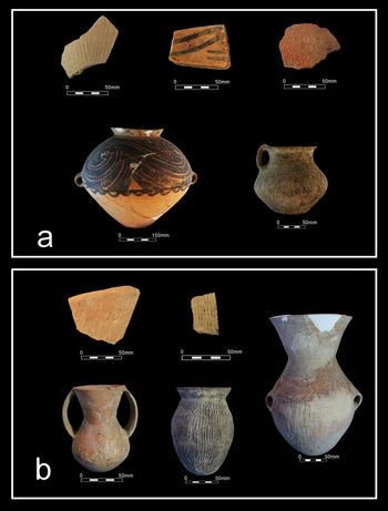
Majiayao-period pottery production is hypothesised to have developed out of an earlier tradition of painted Yangshao-style pottery in the region (Wang Reference Wang2012). Potters during the Majiayao period produced a mixture of coil-built fine and coarse wares. Orange fine wares are generally painted and include bowls, pointed-bottom jars and storage containers. Painted designs are typically geometric and vary between the three major Majiayao sub-phases. The designs are also shared across a wide region, including Gansu, Qinghai and northern Sichuan (Li Reference Li1988; Hung Reference Hung2011). Grey fine wares are typically plain or comb-marked; their function is currently unclear. Coarse wares are normally decorated with crossed-cord marks and appliqué (Figure 2a), and in some cases, show signs of burning that may indicate their use in cooking. Most vessels, except bowls, are large, and could have been used in cooking for or serving an extended family. Use-alteration analysis of painted fine wares from a mortuary context near the Tao River Valley indicates that most vessels were used for storing dry or liquid goods, as well as possibly for fermentation (Skibo Reference Skibo2013; Womack Reference Womack2017).
Typical whole vessels and sampled sherds from local Majiayao (a) and Qijia (b) sites (photographs by A. Womack).
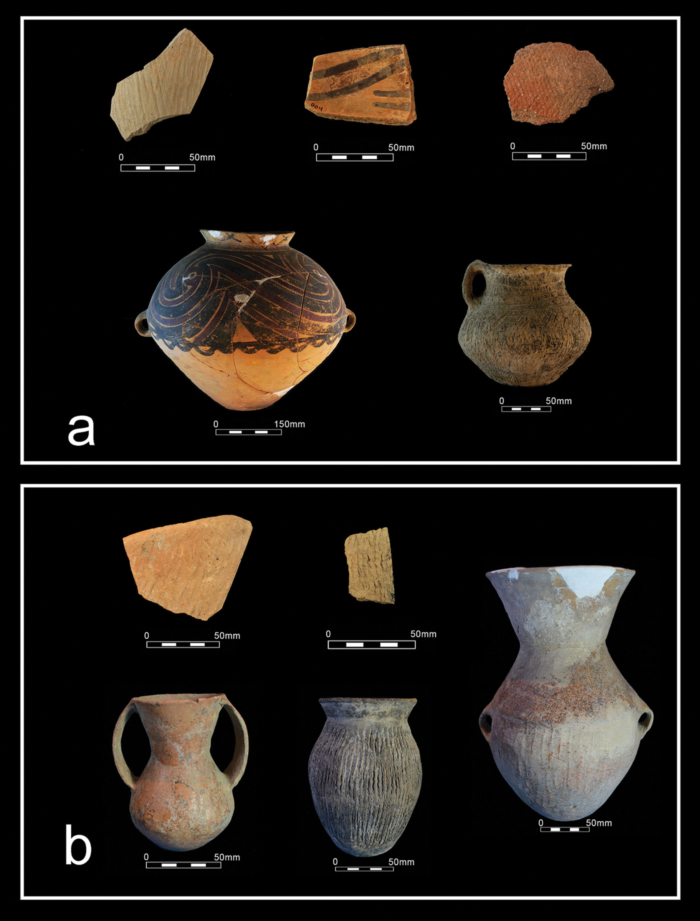
Qijia-period pottery from the Tao River Valley shows similarities in form and surface treatment to vessels found farther east, including pottery associated with the Keshengzhuang II and Changshan Cultures. The nature of any relationship between these groups and late Majiayao-/early Qijia-period peoples in Gansu, however, remains unclear (Wang Reference Wang2012). Qijia pottery is coil-built and vessel sizes are typically smaller than their Majiayao predecessors. Common Qijia vessel forms include plain bowls, small burnished two-handled jars, cord-marked jars and large basket-marked jars (Figure 2b). Stemmed bowls, round-bellied jars and tripods are also occasionally encountered. Use-alteration analysis indicates that the burnished jars were probably used for drinking, while the cord-marked jars were used for cooking. The basket-marked jars were used for storing liquids and possibly for fermentation (Womack Reference Womack2017). While some Qijia-period vessels from other parts of Gansu are painted or have incised decoration, these are rare in the northern Tao River Valley. Generally, there is significant inter-regional variation in common forms and decorative styles of Qijia-period pottery.
Previous research into sourcing of the materials used in Majiayao- and Qijia-period vessels from the Tao River Valley and elsewhere has produced variable results. Using laser ablation inductively coupled plasma atomic emission spectrometry (LA-ICP-AES), Hung (Reference Hung2011) concluded that painted Majiayao vessels produced in the Tao River Valley were probably exported to northern Sichuan for use alongside locally made plainwares. Due to the chemical homogeneity of clay sources in the Tao River Valley, however, Hung was unable to determine whether exchange took place on a local scale. Cui et al. (Reference Cui, Dong, Li, An, Liu, Wang, Wang, Ren, Li and Chen2015) used X-ray fluorescence (XRF) analysis of a small number of sherds from several periods, with results suggesting a lack of inter-regional exchange during the Majiayao period, followed by a subsequent increase in exchange between groups in Gansu and Qinghai during the Qijia. The use of a different analytical technique and the very small sample size in the latter study may explain this variation in results. Aside from sourcing, one study has also recreated some forms of Majiayao-period painted pottery in order to assess production techniques (Li Reference Li2005). The results, however, are very general and do not discuss potential inter-site variation. Thus, virtually no information is available on pottery production materials or techniques from specific sites, and no local comparisons between sites have taken place. Hence, there are considerable gaps in our understanding concerning most aspects of Tao River Valley ceramics, apart from form, decoration and some aspects of long-distance exchange.
Methods and materials
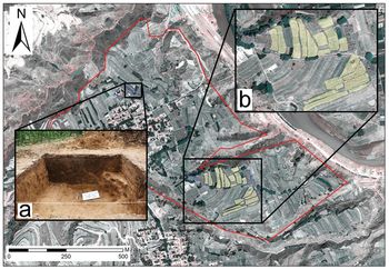
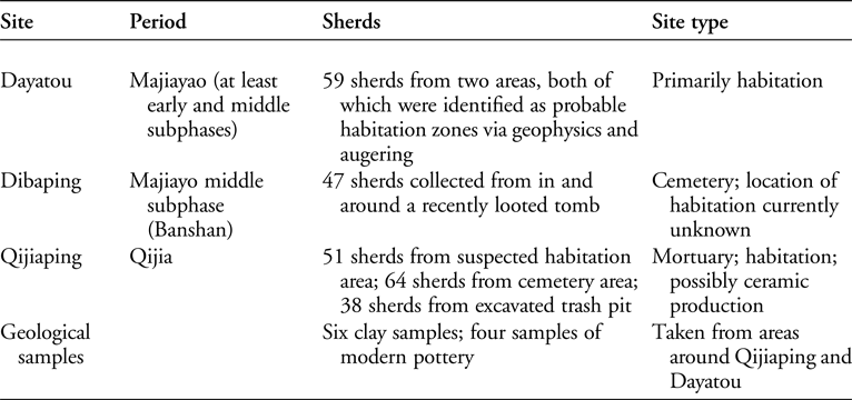
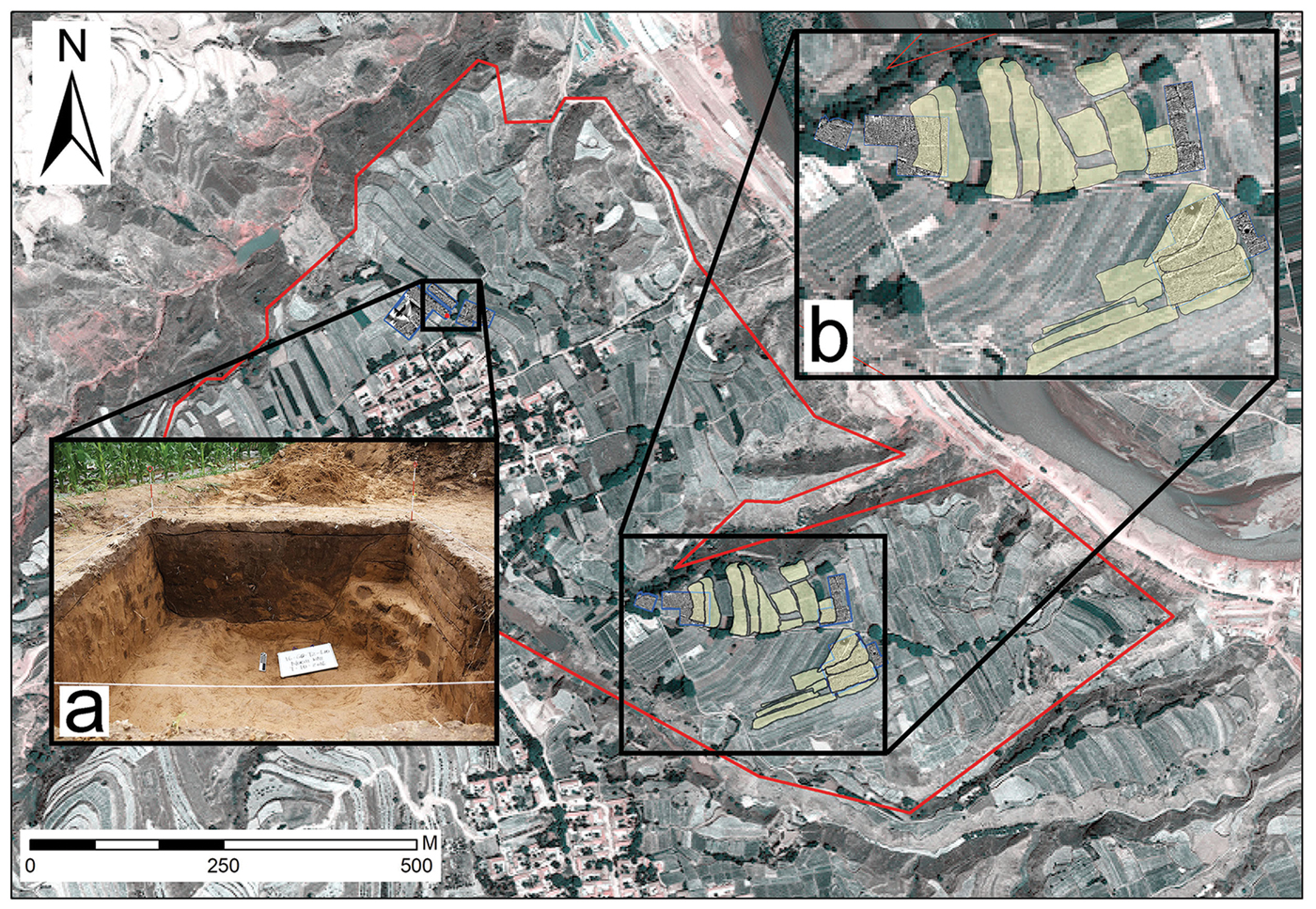
To address questions relating to communities of practice and production techniques used to create Majiayao and Qijia pottery, this study analyses 259 sherds from three sites in the Tao River Valley (Figure 1). These comprise sherds originating from a Majiayao-period habitation context at Dayatou (n = 59), a middle Majiayao-period grave at Dibaping (n = 47) and from habitation and mortuary contexts at the Qijia type-site of Qijiaping (n = 153). Additionally, six samples of natural, local clay and four samples of locally produced modern pottery are analysed (Table 1). Samples from Dayatou and Qijiaping were retrieved primarily during surface survey; geophysical survey at each site, combined with coring at Dayatou and eventual excavation at Qijiaping (Womack et al. Reference Womack, Jaffe, Zhou, Hung, Wang, Li, Chen and Flad2017), allows us, however, to confirm the chronology and nature of subsurface remains underlying the survey areas at both sites (Figure 3). Additionally, comparison of surface and excavated materials at Qijiaping demonstrates that there are no significant differences between the two assemblages.
A map of Qijiaping showing: a) the location of an excavated trash pit; b) how surface survey areas sampled for this study (yellow outline) overlapped with geophysical remote sensing (blue outline) (map by A. Womack; photograph by J. Ko).
This chart lists the number and location of samples from each site in the study along with a description of the site.

Due to the large quantity of sherds, a stratified random sampling strategy was employed at Dayatou, Dibaping and Qijiaping. At Dayatou, samples were taken from immediately above contexts that were identified as early and middle Majiayao period. At Dibaping, samples were taken from sherds found surrounding a looted middle Majiayao-period tomb. Samples at Qijiaping were taken from the surface of areas identified as containing habitation and mortuary remains, as well as from an excavated rubbish pit. The authors and experts from the Gansu Institute of Archaeology dated all sherds stylistically before samples were selected.
Each sample was thin-sectioned at the China Geology Museum's Ceramic Petrography Workshop. Initial analysis of thin sections took place at the Yale University Ceramic Analysis Laboratory using a Zeiss Axio Imager microscope following techniques specified by Whitbread (Reference Whitbread1995). Point counting of between 125 and 300 points—depending on thin section size—was then undertaken at the Shandong University Ceramic Analysis Laboratory on every sample, following techniques described by Stoltman (Reference Stoltman1989, Reference Stoltman1991, Reference Stoltman2001). This technique involves moving across a thin section at 1mm increments, recording what is seen at each point. For this study, intentionally added temper is not separated from natural sand inclusions due to a lack of distinguishing features in local clay. Key results from the petrographic analyses are presented here. The raw data, including photomicrographs of most samples, are available on the China Ceramic Petrography Database on the OpenContext platform (https://opencontext.org/projects/2c5addea-41d5-4941-b2bd-672bc1e60448). Although a small but increasing number of petrographic studies of early Chinese ceramics have been conducted (e.g. Xu et al. Reference Xu, Wang, Chi, Li, Zhang, Holmes, Harbottle, Koshimizu, Manabu and Koichi2001; Stoltman et al. Reference Stoltman, Jing and Tang2009, Reference Stoltman, Yue, Jing, Tang, Burton and Raudsepp2018; Druc et al. Reference Druc, Underhill, Wang, Luan and Lu2018), this study represents the first large-scale petrographic analysis of ceramics from Gansu Province.
Petrographic data
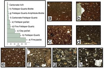
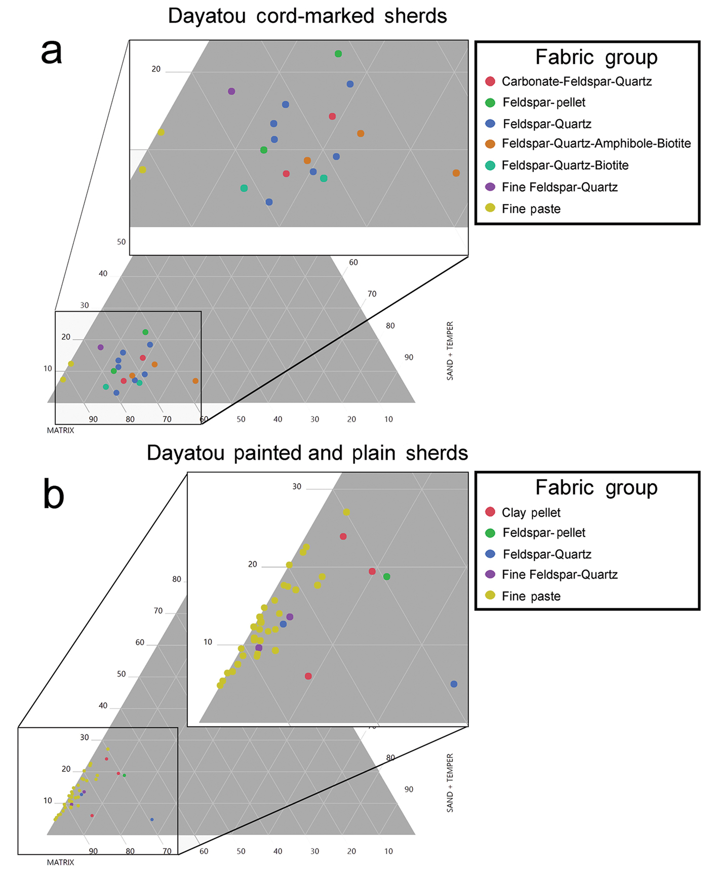
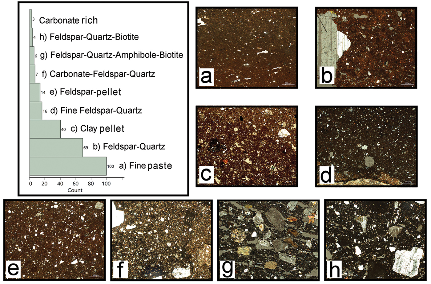
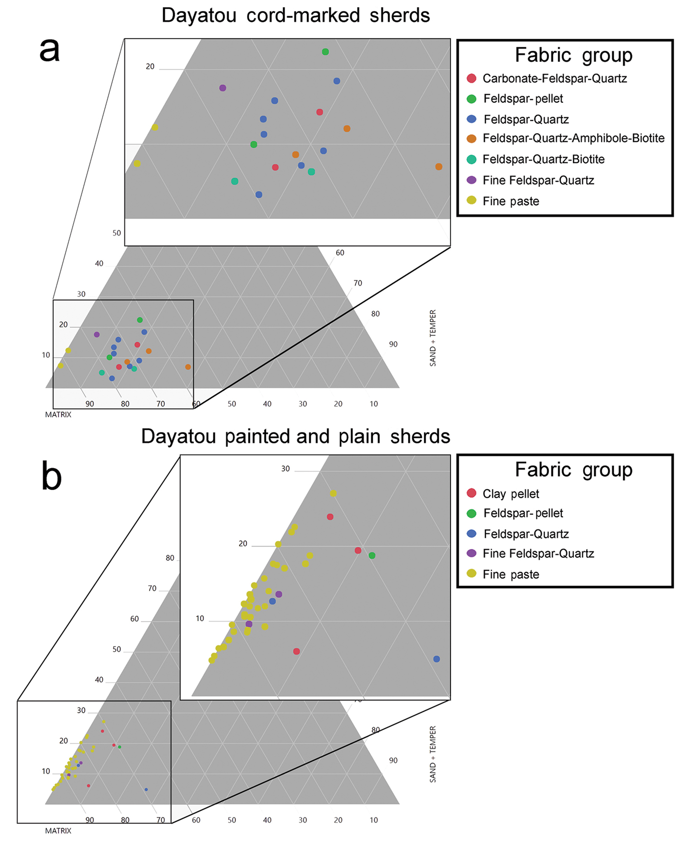
Nine fabric groups were identified among the sherds sampled (Figure 4). Due to significant variability in the quantities of inclusions and silt among sherds within the same fabric groups, point counting was used to quantify these differences more precisely. Results were separated by site and surface decoration. For the Majiayao-period habitation site of Dayatou, cord-marked sherds show a wide variety of fabric types, with seven fabric groups present among only 19 samples (Figure 5a). While the Feldspar-Quartz group is the largest (37 per cent), the other groups are more equally represented. Additionally, aside from the two Fine Paste sherds, all samples fall into the same general range of matrix, silt and sand/temper on the ternary chart. For painted and plain sherds, the Fine Paste fabric group is dominant (80 per cent), although differences in silt levels from 5–25 per cent may indicate some variation in clay sources used, or preparation techniques among sherds in this group (Figure 5b). That other fabric types are minimally represented probably indicates that the use of alternative clay or temper sources, or exchange of finished fine ware was relatively rare.
A graph showing all fabric groups identified in this study with representative cross-polarised photomicrographs of the main fabric types. Additional photomicrographs are available on the China Ceramic Petrography Database on the OpenContext website (https://opencontext.org/projects/2c5addea-41d5-4941-b2bd-672bc1e60448) (micrographs by A. Womack).
Ternary plots displaying the results of petrographic point counting for (a) cord-marked and (b) painted and plain sherds from the Majiayao-period site of Dayatou (chart by A. Womack).
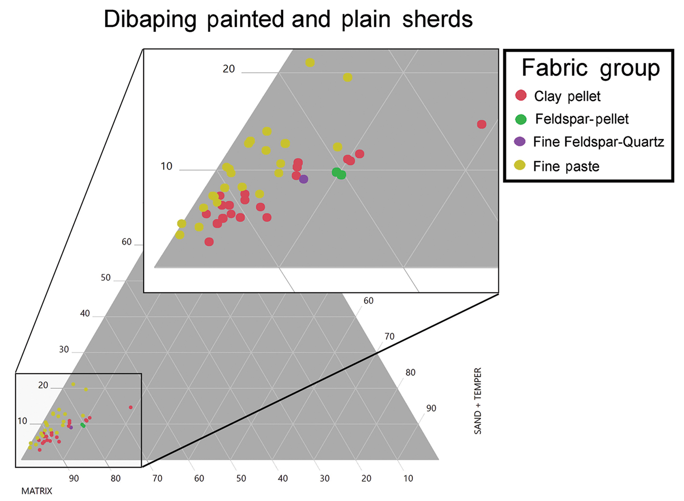
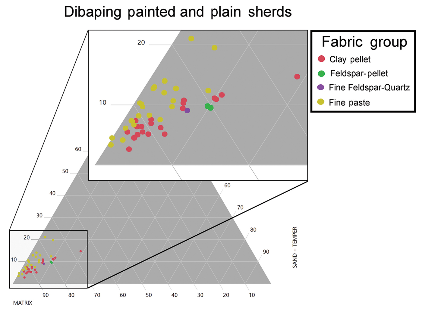
At the middle Majiayao-period cemetery site of Dibaping similar paste groups are observed among the painted and plain sherds sampled, although larger numbers of non-Fine Paste ceramics are present (Figure 6). While Fine Paste sherds still constitute the majority (51 per cent), there is also a large number of Clay Pellet fabric sherds (42.5 per cent). Small numbers of two other fabric types are also present. Variation in silt and sand levels among all fabric groups are also more pronounced, possibly indicating the use of variable clay and temper sources or clay preparation techniques. Cord-marked or other coarse sherds were not recovered from this context.
Ternary plot displaying the results of petrographic point counting for all sherds sampled from the Majiayao-period cemetery of Dibaping (chart by A. Womack).
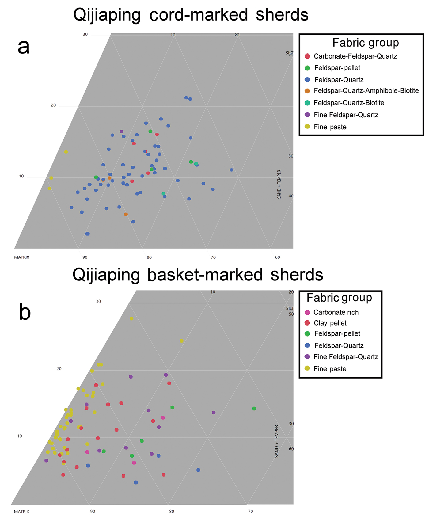
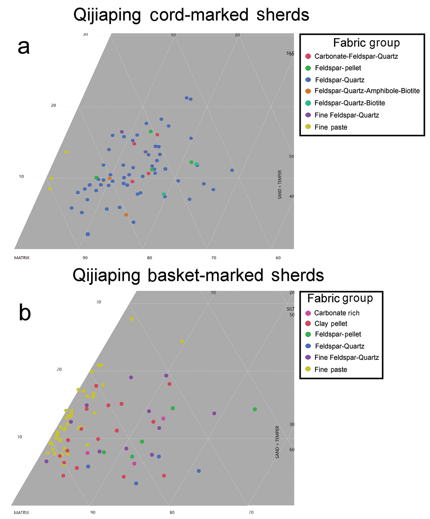
At Qijiaping, the sampled sherds featured cord-marks, which generally relate to coarse cooking vessels, and basket marks, which generally come from finer paste containers. As variation in results between sampling contexts was minimal, all of the samples are presented together here. Among cord-marked sherds, seven fabric groups can be identified (Figure 7a), which are identical to the seven groups observed among the cord-marked sherds at Dayatou. The dominant fabric group is Feldspar-Quartz (75 per cent), while all other groups are represented by fewer than five sherds (<7 per cent) each. Once again, aside from the small number of Fine Paste sherds, all of the samples fall within the same general range in terms of the quantity of silt and sand inclusions. There is also significant variability in paste type for basket-marked sherds (Figure 7b). While nearly half of the basket-marked sherds fall into the Fine Paste fabric group (49 per cent), several other groups are also strongly represented, including Clay Pellet fabric (21 per cent), Fine Feldspar-Quartz (14 per cent) and Feldspar-Pellet fabric (11 per cent) groups, among others. These fabric groups all match those observed at the earlier Majiayao-period sites of Dayatou and Dibaping, aside from the Carbonate-rich fabric group, which is not present in the previous period.
Ternary plots displaying the results of petrographic point counting for (a) cord-marked and (b) basket-marked sherds from the Qijia site of Qijiaping (chart by A. Womack).
Discussion
This study focuses primarily on clay recipes as one aspect of ceramic production that can provide significant information on the technological choices of potters within their communities of practice. There appears to have been several distinct clay and temper sources exploited for the production of pottery during the Majiayao and Qijia periods. At each site for each time period, a single fabric group dominates all other groups. For cord-marked sherds at Dayatou and Qijiaping, this is the Feldspar-Quartz fabric group. This fabric was probably produced by taking local clay—which is very pure with low quantities of sand and silt—and then adding feldspar and quartz-rich sand from the nearby Tao River. Some variation is apparent in the amount of sand and silt added. This possibly reflects individual choice when adding temper, while staying within an ideal range for producing this type of vessel. Similarly, when potters at these sites produced fine ware vessels, they appear to have relied on the pure, local clay, with natural clay variability or variations in processing techniques limited to differences of only ±6 per cent in silt levels and 3–4 per cent in sand levels.
The persistence in the dominant fabric groups from the Majiayao to the Qijia periods seems to indicate that, despite the passing of hundreds of years and a complete shift in the ceramic forms being produced, the same local resources and production techniques were still being utilised. This speaks to not only the conservative nature of production and learning, but also of the success of these producers in utilising these techniques and materials. While there was clearly a social shift that motivated potters to change from producing Majiayao- to Qijia-style pots, it was not so extensive that they changed the raw materials they selected or the techniques they used to prepare their clay. Additional analysis of manufacturing marks and standardisation of whole vessels from both periods further reinforces the notion that shifts in pottery were confined predominantly to form and surface treatment (Womack Reference Womack2017).
It is equally notable that not only was local production sustained between the two periods, but exchange of vessels or raw materials with other groups also appears to have persisted. While the sources of the clay and temper used to produce other fabric groups (not of local origin) are currently unknown, sampling around Dayatou and Qijiaping indicates that the raw materials needed to make these fabrics are not readily available locally. Potters operating at these sites would therefore have needed to travel to other sources or trade for raw materials to produce these other fabric types. Alternatively, whole vessels could have been produced elsewhere and imported through exchange networks or by other means. Regardless, the key point is that these other fabric types also persisted between periods.
For all categories of pottery sampled, the non-dominant fabric groups are also identical between the two periods, with only one fabric type from Qijiaping (Carbonate-rich) not present at the earlier Majiayao-period sites. This indicates either that communities of potters were passing down knowledge of other raw material sources between the middle Majiayao and late Qijia periods or that exchange relationships with other communities persisted between periods. Future research focusing on the provenancing of raw materials used to produce these fabric types—and on types used at other sites—should clarify whether vessels with these paste recipes were produced elsewhere, or whether only the raw materials were imported. Regardless, the clear continuity in either knowledge of raw materials or exchange relationships indicates that, although vessel types changed significantly over time, the underlying communities producing and exchanging these goods were surprisingly resistant to any wider changes between periods.
Conclusion
This research reinforces the importance of examining underlying production techniques, alongside surface treatment and vessel form in order to understand the relationship between changes in ceramic production and larger social shifts. As demonstrated here in the northern Tao River Valley, despite significant diachronic shifts in pottery form and decoration, underlying paste recipes and raw materials persisted for centuries. The communities of practice that produced these goods were therefore conservative in their production methods, directly passing down knowledge and techniques over the centuries. Thus, while potters clearly decided to adopt new ceramic forms and surface treatments, the persistence of underlying production knowledge seems to rule out large-scale, climate-change-induced migration and population replacement as being responsible for the changing ceramic styles. It also demonstrates that the adoption of other new technologies, such as metal-working and new domesticates, does not appear to have had a significant impact on pottery production.
This research demonstrates the effectiveness of petrographic analysis for examining persistence in ceramic sourcing and exchange relationships over time. In this case, dominant paste recipes can be attributed to locally sourced raw materials, while other paste groups probably resulted from the exchange of non-local clay or finished vessels, or the exploitation of non-local clay resources. The diachronic persistence in the presence of these clay groups further reinforces the notion that significant changes in ceramic production practices did not occur between the Majiayao and Qijia periods in the northern Tao River Valley. The results also raise questions about the nature and scale of interactions that brought non-local pottery or raw materials into these communities. While additional research is currently underway to identify the location of exchange partners and raw material sources, wider application of petrography in China is required to investigate the many exchange relationships that have been proposed for the Majiayao and Qijia periods.
Ideally, similar methods can be applied to other investigations in China, both to improve our understanding of early interaction and to refine our understanding of cultural change—the latter is currently heavily based on observing changes in pottery form and decoration. Connections between the Houli Culture (6550–5550 BC) of Shandong Province and earlier groups in the area, for example, are posited on the basis of similarities in some aspects of pottery vessels, such as folded rims. In the same region, changes in pottery style have also been used to hypothesise potential migrations, including the impact of non-local groups on the foundation of the subsequent Beixin Culture (5000–4100 BC) (Wang Reference Wang and Underhill2013). In both cases, examination of paste recipes could potentially provide information on the location of raw materials and the methods of ceramic production, allowing for a deeper understanding of potential continuities or changes in communities of producers. Indeed, this is now being addressed with a recent analysis of ceramic production during later time periods in Shandong Province (Druc et al. Reference Druc, Underhill, Wang, Luan and Lu2018), as well as with increasing numbers of studies investigating diachronic changes in ceramic production in other parts of the world (D'Ercole et al. Reference D'Ercole, Budka, Sterba, Garcea and Mader2017; Ting Reference Ting2017). These studies should lead to more nuanced understandings of the complex relationship between ceramic form, production and social organisation in early China and beyond.
Acknowledgements
Funding for the petrographic research was provided by the National Science Foundation (Doctoral Dissertation Improvement Grant #1541275), with additional funding from the Fulbright Foundation, as well as from the Council on East Asian Studies, the MacMillan Center, and the Department of Anthropology at Yale University. Funding for the Tao River Archaeological Project is provided by the American School of Prehistoric Research, the Asia Center at Harvard University, and the Gansu Provincial Institute of Archaeology. Research facilities were generously provided by Yale University and Shandong University. Many thanks to Shuicheng Li of Peking University and the entire staff of the Gansu Institute of Archaeology for facilitating this work. Feedback on all aspects of research was kindly provided by Anne Underhill and Richard Burger, with additional input from Camilla Sturm and two anonymous reviewers. Finally, many thanks to the people of Qijiaping and Dayatou for their generosity.