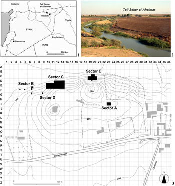


Archaeologists have now agreed that the emergence and development of food production in Neolithic Southwest Asia was a cultural process involving a wide range of changes not only in subsistence economy but also in technology, social systems, symbolism, and other aspects of human behaviour. This paper discusses one of these changes, the ‘domestication of water’, which represents the innovative methods that humans used to control water in the Neolithic period and afterwards (eg, Garfinkel et al. Reference Garfinkel, Vered and Bar-Yosef2006; Gebel & Fujii Reference Gebel and Fujii2010; Mithen Reference Mithen2010). Water control took a variety of forms, including the construction of reservoirs, dams, and wells. While the examples of this practice have been primarily reported from regions along the Mediterranean coast, notably the Levant and Cyprus, this paper reports on the new discovery of a Late Pre-Pottery Neolithic B (PPNB) water-well in inland Northeast Syria, specifically at Tell Seker al-Aheimar (Fig. 1.1).
Geographic settings of Tell Seker al-Aheimar. 1: Location of the site. 2: Distant view of the mound from the northeast 3: Excavation areas. Grey areas indicate modern houses

The discovery itself, which demonstrates that water-control through the construction of wells was a widespread phenomenon encompassing the far inland region of Upper Mesopotamia, has been briefly mentioned in the preliminary excavation reports of Tell Seker al-Aheimar (Nishiaki Reference Nishiaki2009; Reference Nishiaki, Kanjou and Tsuneki2016; Reference Nishiaki, Abdul-Mashih and Nishiyama2018). However, the present paper is the first to provide a detailed description of the context of the excavation as well as the stratigraphy, construction technology, spatial positioning in the settlement, dating, and associated artefacts, along with our current interpretation of this finding’s potential to contribute to a better understanding of the Neolithisation processes in this part of Syria.
THE SITE AND ITS CHRONOLOGY
Tell Seker al-Aheimar is a Neolithic site located about 45 km northwest of Hassake, on the right bank of the Khabur River. It is one of the largest Neolithic mounds (c. 4.5 ha) thus far known in the Jazira Plain of Syria and Iraq, covering an oblong area of 300 m by 180 m with a height of 11 m from the surrounding field (Fig. 1.2). The excavations were carried out for 11 seasons between 2000 and 2010 by a team from the University of Tokyo (Nishiaki Reference Nishiaki, Abdul-Mashih and Nishiyama2018). All five areas of excavations (Sectors A to E) yielded similar cultural sequences, showing that the Neolithic settlement was widely distributed across the mound (Fig. 1.3).
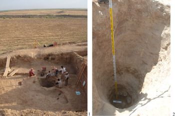
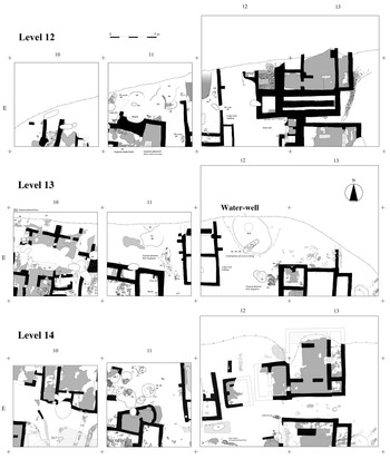
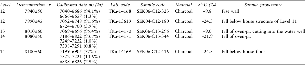
The water-well was located in Sector C (Figs 2 & 3). This area consists of four squares (10 × 10 m) and portions of the adjacent squares, which comprise a total exposure area of about 500 m2. Squares D11, D12, and E12 included virgin soil. The cultural deposits of Sector C are about 7 m thick and have been divided into 20 occupation levels. Except for thin layers of the Chalcolithic (Ubaid) period on top, all 20 occupation levels belong to the Neolithic period. Level 1 is dated to the Proto-Hassuna of the Pottery Neolithic, Levels 2–8 to the Pre-Proto-Hassuna of the Pottery Neolithic (Nishiaki & Le Mière Reference Nishiaki and Le Mière2005), and Levels 9–20 to the Late PPNB. The water-well was discovered on Level 13 of Square E12, radiocarbon-dated to approximately 7000 cal bc (Table 1).
Excavations of the water-well. 1: The water-well looking from the south. The Khabur River is seen behind the excavation. 2: The inside of the water-well

Plans showing the architecture of Levels 12–14, Sector C

RADIOCARBON DATES FOR LEVELS 12–14 OF SECTOR C, TELL SEKER AL-AHEIMAR (NISHIAKI Reference Nishiaki2007, 120)

* dates have been calibrated using the INTCAL13 calibration curve (Reimer et al. Reference Reimer, Austin, Bard, Bayliss, Blackwell, Bronk Ramsey, Butzin, Cheng, Edwards, Friedrich, Grootes, Guilderson, Hajdas, Heaton, Hogg, Hughen, Kromer, Manning, Muscheler, Palmer, Pearson, van der Plicht, Reimer, Richards, Scott, Southon, Turney, Wacker, Adolphi, Büntgen, Capano, Fahrni, Fogtmann-Schulz, Friedrich, Köhler, Kudsk, Miyake, Olsen, Reinig, Sakamoto, Sookdeo and Talamo2020) and OxCal v4.4 (Bronk Ramsey Reference Bronk Ramsey2009; http://c14.arch.ox.ac.uk/)
THE PPNB WATER-WELL AT TELL SEKER AL-AHEIMAR
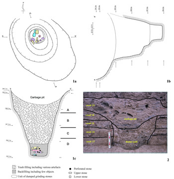
The recognisable mouth of the well shows an oval shape with a major axis over 4 m and a minor axis of 3 m (Fig. 4). This large size is due to another pit which overlaps the well-pit. The overlying pit, which scraped the upper part of the well, is located slightly to the south (Fig. 4). The recovery of plenty of obsidian and flint artefacts, animal bones, and gypsum-plastered floor fragments from the fills indicate that the overlying pit was used as a rubbish pit. Although the precise size cannot be determined, the remaining parts suggest that the water-well originally had a circular opening with a diameter of approximately 2 m. The well pit extended through the underlying occupation Levels 14–20 into the virgin soil and was approximately 4.5 m deep (Fig. 4). The bottom is rather small and flat, circular in shape, and about 80 cm in diameter, meaning that the pit exhibits a truncated-cone shape. However, there are a few steps that are noticeable on the southern wall (Fig. 4.1b), which may have helped the Neolithic diggers to work in the deepest parts.
Plan and section of the water-well. 1a: Plan. 1b: Section a-a'. Note the steps on one slope and the absence of interior stone-lining. 1c: Section b-b'. The find levels of the four units of ground stones are also indicated. For A to D, see the text. 2: Photograph of a section close to the top part of the water-well. Note the abundant architectural debris in the latter deposits

The well penetrated into the deposits with the following stratigraphy (Fig. 4.1c). The height is shown in metres above sea level (m asl).
-
A: Cultural deposits of Levels 14–20 (289.20–287.80 m asl);
-
B: Reddish-brown sandy sediments, corresponding to the top part of the virgin soil (287.80–286.90 m asl);
-
C: Alternating layers of dark brown muddy soil, whitish-grey mud, and yellowish-brown sandy soil (286.90–286.20 m asl);
-
D: Gravel layer consisting of carbonate rocks (oncoids), typical of the gravel of the Khabur River (Hori et al. Reference Hori, Watanuki, Chen, Komatsubara, Oguchi, Oguchi, Hayakawa and Nishiaki2006) (286.20–285.10 m asl).
This well was dug on virgin soil (B–D) to reach an ancient gravel layer (D), which probably encompassed the ground water table in the Neolithic period. The lack of water at this level today is almost certainly related to the modern underground water table, which is lower due to pumping for irrigation, among other reasons. The present water level of the Khabur River, which fluctuates according to the season, is approximately 50 cm below the bottom of the well (Fig. 5).
Schematic section of the water-well and the Khabur River plain

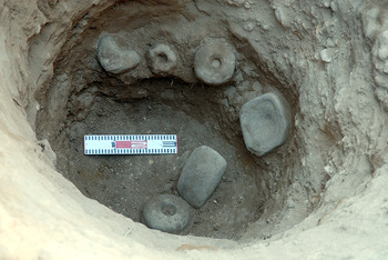
The fill of the water-well is divisible into two parts, with a border approximately 70 cm from the bottom. The upper part comprises light brown ashy fill containing plenty of gypsum-plastered floor fragments (Fig. 4.1c) as well as animal bones and lithic debris, while the lower part is characterised by rather homogeneous sediments of greyish brown sandy mud. The latter contained virtually no debris, but a small amount of river gravel was present, which was considered to have come from the gravel layer at the bottom of the well. This clear contrast is evidence of the different uses of the two parts. We interpret that the upper deposits represent fill from the period after the abandonment of the well (Fig. 4.2), and the lower deposits were accumulated during the use of the well. Although the lower part is primarily made up of natural sediments, it was not sterile in terms of cultural remains. It yielded a group of fascinating finds: a total of 14 ground stone objects (two pestles, two hand stones, two pounding stones, two basin querns, and six perforated stones) and one alabaster rock (Fig. 6). Remarkably, all of the ground stones are still usable, unlike the waste materials recovered from the upper part of the fill. It is most likely that these stones, made of either basalt, limestone, or alabaster, were thrown into the well on purpose, for reasons as yet unknown. The alabaster rock exhibits no visible artificial modifications (second from the left in the front row in Fig. 6). However, its large size of 6 × 7 × 5 cm and appealing pinkish colour points to its potential use for manufacturing stone bowls and beads. As the alabaster is not locally available in the Khabur plain, it was imported to the settlement probably as a raw material for prestige goods.
A complete set of the ground stones from the water-well

The stratigraphic position of these stone finds suggests that they were dumped over time. At least four dumped units, separated by 20–30 cm in altitude from each other, were identified (Fig. 7; Table 2). The four assemblages show interesting features. First, each unit yielded only a few stones. Second, all of the four units contained perforated stones (Fig. 6). It should be emphasised that perforated stones are rare objects at Tell Seker-al Aheimar. There are only 11 perforated stones in the large ground stone collection of this site, consisting of hundreds of specimens, among which as many as six examples were recovered from the water-well. Further, all of the six perforated stones are complete, while those from the other contexts contain only two complete pieces.
Ground stones of Units 3 and 4 recovered from the bottom of the water-well. Note the difference in their discovery levels

DISCOVERY UNITS OF THE GROUND STONES FROM THE WATER-WELL

The water-well contained charcoal samples in its massive fillings. However, we considered that their radiocarbon dating could not provide any grounds to specify the date of either the initial construction or entire use life of the well, because of the uncertainty in the origins of the charcoal. We thus dated the well based on stratigraphic evidence. The date from an oven-pit of Level 13 cutting in the well (Fig. 3) provides a terminus ante quem date, which is confirmed by the dates of Level 12 (Table 1). Further, the dates for Level 14 point to a terminus post quem. All these dates firmly place this water-well at c. 7000 cal bc, at the end of the Late PPNB period in Syria. At the same time, similar dates from these three levels indicate that Level 13 was short-lived, perhaps lasting for only 20–30 years. This estimate leads to a suggestion that the water-well was even more short-lived. As the stratigraphy shows, the well was buried soon after its abandonment and another large pit was dug into the area, probably for rubbish disposal, within the period of Level 13. The area of and surrounding the water-well was wholly transformed in Level 12 into a building area as it was in the underlying Level 14 (Fig. 3).
DISCUSSION
The shape and sedimentological observations strongly support our interpretation that the deep pit within Level 13 at Tell Seker al-Aheimar was a water-well, the oldest one ever known in Upper Mesopotamia. This is an important addition to the current issue of domestication of water in the Neolithisation processes of Southwest Asia. One of the characteristic features of Neolithisation is increasing human control over environmental conditions, called domestication, including not only the ecology of plants and animals but also the landscape surrounding settlements. The construction of the water-well is considered a part of this process (Garfinkel et al. Reference Garfinkel, Vered and Bar-Yosef2006; Gebel & Fujii Reference Gebel and Fujii2010; Mithen Reference Mithen2010). As the oldest water-wells in prehistory date back to the pre-farming period (Vance Haynes et al. Reference Vance Haynes, Stanford, Jodry, Dickenson, Montgomery, Shelley, Rovner and Agogino1999), the digging of a well for water acquisition cannot be assigned solely to Neolithic societies. However, the obvious increase in the number of water-wells in the Neolithic and later periods within Southwest Asia justifies this practice be interpreted in the context of the development of farming societies.
The oldest water-wells in Southwest Asia have been found in Cyprus at the Parekklisha-Shillourokambos (Guilaine Reference Guilaine, García-Puchol and Salazar-García2017) and Kissonerga-Mylouthkia (Koutrafouri Reference Koutrafouri, Koutrafouri and Sanders2013) sites and date from about 8000 cal bc, comparable to the Early PPNB of the Levant. Wells that penetrate into the limestone bedrock, over 8 m deep, have been recovered. These early examples are followed by those of Late PPNB and Pottery Neolithic water-wells in the Levantine mainland. Fine stone-lined wells have been discovered at Atlit Yam, c. 7000 cal bc (Galili et al. Reference Galili, Gopher, Rosen, Horwitz and Peltenburg2004) and Sha’ar Hagolan, c. 6300 cal bc (Garfinkel et al. Reference Garfinkel, Vered and Bar-Yosef2006). A simple shaft well without a stone lining was found at Hacilar VI, c. 6000 cal bc (Mellaart Reference Mellaart1970), in Anatolia. The wells at Khirbet Garsour (Campbell Reference Campbell1992; Wilkinson & Tucker Reference Wilkinson and Tucker1995, 61) and Arpachiyah (Mallowan & Rose Reference Mallowan and Rose1935), Northern Iraq, show similar structures and also belong to the Pottery Neolithic period, c. 6300 cal bc and later.
This very limited dataset shows that well-digging was a widespread practice across the Fertile Crescent during the Pottery Neolithic. The Late PPNB water-well at Tell Seker al-Aheimar, the earliest example in Upper Mesopotamia, provides us with fresh insights into water management in its incipient stage. The following features of this well should be noted for further discussion.
First, the communal nature of the water-well must be highlighted. The laborious work evidently required to construct wells and their location in open areas have often led researchers to point out activities at the public level (Garfinkel et al. Reference Garfinkel, Vered and Bar-Yosef2006; Koutrafouri Reference Koutrafouri, Koutrafouri and Sanders2013). The discovery context at Tell Seker al-Aheimar supports this view. The settlement layout in Sector C of Tell Seker al-Aheimar was remarkably consistent throughout PPNB occupation levels. It consisted of rectangular buildings with mud-brick walls with an east–west longer axis in Squares E10/11 and E13. In Square E12, between these building complexes, there was a central building that had a north–south longer axis (Fig. 3). This spatial pattern was maintained over a long period despite the frequent rebuilding processes of mud-brick architecture. This distinct spatial patterning leads us to regard the central building as a communal building for the households in this part of the settlement. Features of the central building which are unlike those at other buildings include its larger room size, reminiscent of the ‘Large-Room Buildings’ of the Çayönü site, Anatolia (Erim-Özdoğan Reference Erim-Özdoğan, Özdoğan, Besgelen and Kuniholm2011), and the large fireplace situated in the centre of one room. We suggest that the relatively spacious area surrounding this building, associated with several pits, including cooking pits with burnt stones at the bottom, was also used for a communal purpose. In this regard, it is noteworthy that the Level 13 deposits are almost missing in the northern part of Square E13 (Fig. 3). The Level 14 architecture was identified immediately below the Level 12 buildings. We assume that the surrounding ground in Level 13 was scraped to obtain sediments to bury the well. The amount of architectural debris in the upper part of the well filling would align with this practice (Fig. 4).
Second, the water-well was likely to have functioned as a place not only for obtaining fresh water but also for other activities, which may have included some sort of ‘ritual’. As the ethnographic research has long revealed the common practice of ritual at wells among traditional (and industrial) societies across the globe (Moore & Terry Reference Moore and Terry1894; Masani Reference Masani1918), the same seems to be the case for the Neolithic societies of Southwest Asia. Indeed, the well ritual has been a major research subject even for the early water-wells in Cyprus (Koutrafouri Reference Koutrafouri, Koutrafouri and Sanders2013). The well of Tell Seker al-Aheimar provides a unique dataset to examine this possibility and its variability in the PPNB of Upper Mesopotamia. The discovery of a dozen complete ground stone objects and a precious alabaster stone is a feature that has not been identified at the other known Neolithic wells. Considering their value for the Neolithic society and the absence of other objects from the same context, the deposition should be considered a result of intention rather than the result of accidentally being dropped or being disposed as rubbish. The performance of a ritual or ceremony around the water-well of Tell Seker al-Aheimar warrants a hypothesis for consideration.
Although we are unable to specify what sort of ‘ritual’ was conducted, the following observations would be useful for future studies. (1) The stratigraphic position of the ‘dumped’ stones suggests its repeated practices in a relatively short period (Table 1; Fig. 4.1c), whether on a seasonal basis, during special occasions, or at other times. (2) The dumping appears to have been made during the use of the well. This interpretation is based on how all the dumped stones were encompassed in the muddy natural sediments, and that the lowest dumping unit was found so close to the bottom of the well. The situation differs from the conclusion for the Cyprus well ritual, which is believed to have taken place ‘after the wells had dried up and/or ceased to function as a viable water source’ (Koutrafouri Reference Koutrafouri, Koutrafouri and Sanders2013, 91). (3) The activities can be related to the use of perforated stones. As noted earlier, perforated stones are very rare at this settlement. Only eight complete pieces have been identified in its huge ground stone tool collection, with as many as six having been recovered from this well. If the perforated stones can be interpreted as maceheads or a symbol of power, they suggest that a chief of the community could have controlled the activities. This is in fact the interpretation proposed for the discovery of a macehead from Well 133 of Kissonerga-Mylouthkia, Cyprus (Koutrafouri Reference Koutrafouri, Koutrafouri and Sanders2013, 91). In this way, the evidence from Tell Seker al-Aheimar exhibits both similar and dissimilar elements with what has been suggested for the ritual at the earliest wells of Cyprus. This fact suggests the practice of a wide range of well rituals in the Neolithic period.
Finally, we would like to refer to the specific geographic setting of the water-well in the local environment. The settlement of Tell Seker al-Aheimar is situated near a permanent water source, the Khabur River (Figs 1.2, 1.5). Therefore, it is unlikely that the well was constructed merely for obtaining fresh water. This setting contrasts with that of the water-wells of Cyprus (Koutrafouri Reference Koutrafouri, Koutrafouri and Sanders2013; Guilaine Reference Guilaine, García-Puchol and Salazar-García2017) and the Levantine coast (Galili et al. Reference Galili, Gopher, Rosen, Horwitz and Peltenburg2004), which were situated in an environment that had a risk of water scarcity, but it is similar to the well at Sha’ar Hagolan (c. 6300 cal bc), situated near the permanent river Yarmouk (Garfinkel et al. Reference Garfinkel, Vered and Bar-Yosef2006). While this pattern can be interpreted in various ways, including the possibility that the well represents a status symbol in a given society (Mithen Reference Mithen2010, 5267), the excavators of Sha’ar Hagolan posited that the well was constructed to guarantee the availability of good quality water and avoid the use of potentially polluted river water. I consider this interpretation also applicable to our case. The pollution of the river water must have been an increasingly serious concern at a large agricultural village like Tell Seker al-Aheimar, which accommodated a large population and animal herds.
Based on the above, we argue that the water-well played an important social and economic role at the Neolithic settlement of Tell Seker al-Aheimar. If that is the case, one may ask why we discovered a well only in Level 13 of Sector C. It is the sole discovery in the nearly 1000 square metres of excavated areas with up to 20 occupation levels (Sectors A to E). In addition, a further question may be raised as to why the use of the water-well of Level 13 was so short-lived. We suggest that an answer may be sought in the difficulty of the maintenance of water-wells at mound settlements. As the mound grows higher over time, the wells require regular maintenance in response to the increasing ground level. Such maintenance has been indeed reported for the Halafian settlement of Arpachiyah, Iraq (Mallowan & Rose Reference Mallowan and Rose1935). This inevitable consequence may have encouraged the communities to construct water-wells away from the core area of the settlement. The construction of a well farther from the domestic area would also have had the advantage of avoiding the risk of water pollution. If so, the wells may have escaped archaeological excavations that often focus on the central part of the mound.
CONCLUSIONS
The Late PPNB water-well at Tell Seker al-Aheimar demonstrates that water control through well-digging was practiced in Upper Mesopotamia around 9000 years ago. It is one of the earliest water-wells recovered to date in mainland Southwest Asia, contemporary to the site of Atlit-Yam on the Mediterranean coast. The important findings of the water-well at Tell Seker al-Aheimar include its communal nature in construction and use, which was likely to have involved non-daily activities like ritual or ceremony, suggesting a certain level of social organisation at this stage of the Neolithic. They also highlight the unique positioning of the well close to the permanent running water of the Khabur River, suggesting that the major purpose of the well-construction was to guarantee the procurement of non-polluted water, avoid sharing the river water with herd animals, as well as supporting the growing population.
A case study in the Jordan Valley has identified the Pottery Neolithic of the late 7th millennium and later a key period of intensification of water management (Mithen Reference Mithen2010). The increase of the discoveries of water-wells in the Pottery Neolithic period in Iraq suggests that this view is applicable to Upper Mesopotamia as well. That the water-well of Tell Seker al-Aheimar retains all the known features from the examples that occurred during the following millennium seems to make it a herald of those later developments.
Acknowledgement
The present study was supported by a grant from the Japanese Ministry of Education, Culture, Science, Sports, and Technology (16H06408).