

Introduction
The concept that location can influence health is very old. As far back as in the 4th century bc, it was observed that certain diseases tend to occur in some places and not in others. Hippocrates (460 to 377 bc) mentions this in his book ‘Airs, Waters and Places’, which is the first known work on what is now called spatial epidemiology (Rinaldi et al., Reference Rinaldi, Musella, Biggeri and Cringoli2006). However, it was not until geographical information systems (GIS), satellite-based remote sensing (RS) and other computer-assisted applications made it possible to translate datasets of spatio-temporal frequencies of discovered phenomena into annotated maps that the capacity and versatility of these methods were fully realized. Predictions produced by this approach can be highly useful with regard to disease intervention. Historical examples of this approach include the world map of diseases produced by the German physician Finke in 1792, related by Barrett (Reference Barrett2000), and the mapping of yellow fever occurrences in the harbour of New York in 1798, related by Stevenson (Reference Stevenson1965). The map of the addresses of cholera victims, shown in 1854 to be related to the location of water supplies in London's Soho district by Snow (Reference Snow1855), is perhaps the most famous account. The birth of the germ theory about the same time notwithstanding, the causal relationship between waterborne cholera bacteria and the disease had yet to be shown beyond doubt. In fact, despite the invention of the microscope almost 200 years earlier, it was not until the last quarter of the 19th century that the pieces started to fall into place. The 1903 publications by Smith and Stiles, who demonstrated that hookworm infection in Texas was typically restricted to the eastern part of the state, where the soils were the sandiest, are testament to the continuing progress in this field of enquiry (Brooker & Michael, Reference Brooker and Michael2000).
The 1792 mapping of yellow fever and the 1854 cholera epidemic marked the birth of the idea that diseases can spread, directly as well as indirectly, to humans and animals. However, despite our current, well-developed understanding of infectious agents and their interrelationship with humans, vectors and intermediate hosts, it should come as no surprise that further progress is on the cards. Indeed, this line of investigation has turned out to be immensely successful, and the past few decades of development have opened up vistas of previously unimaginable power. The epidemiological toolbox has grown and diversified beyond recognition, adding general GIS, satellite-based RS, geographical positioning systems (GPS) and spatial statistics to the arsenal. These technologies continue to develop with lightening speed, putting ever more sophisticated, yet user-friendly, instruments and software into our hands. Moreover, facilitated by instant access to data and applications through the Internet, we are already well into the next extension of the concept. For example, Google Earth did not exist 10 years ago, yet this aid is already used ubiquitously by scientists and laymen alike.
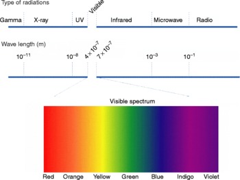
The new geospatial technologies came about as ‘spin-offs’ from the electronics industry, the launching of satellites and the rise of computer technology in the 1980s. These techniques can be used for visualization and analysis of spatial data in the terrain. Manipulation and processing of the information in the form of overlay rasters provide a way of annotating maps in an easily accessible manner. Although airborne photography revolutionized cartography, the real breakthrough for RS did not come until the area studied could be shown multiple times in a standardized manner and the cameras complemented with instruments capable of recording more than just the visible part of the electromagnetic spectrum (fig. 1). Driven by military and economic needs, the convergence of such diverse fields as spectral physics, earth sciences, computer technology and advanced statistics produced an array of tools that are now applied for epidemiological investigations. Dr Barnett Cline was a true visionary when he, almost 40 years ago (Cline, Reference Cline1970), realized the possibilities on offer for epidemiological research and public health (Cline, Reference Cline2006). However, his peers were initially slow to follow his lead and it took more than a decade before medical and veterinary research papers in this area started to appear regularly. The new techniques are particularly useful for the study of viral, bacterial and parasitic infections, which rely on intermediate hosts to complete their life cycles or on vectors for their spread. Since these hosts/vectors are particularly vulnerable to changes in temperatures, humidity, vegetation, etc., knowledge of the limits for the distribution of, for example, the snail hosts of schistosomiasis or the mosquitoes that carry malaria, enables risks to be estimated with a good level of accuracy. Thus, if the environment changes sufficiently to support their intermediate hosts or vectors, an area could pose a risk for humans or other mammals even if the infections in question were previously unknown there.
A sensor's spectral resolution specifies the number of spectral bands from the electromagnetic spectrum in which the sensor can collect reflected radiance. Both the number of bands and their position in the electromagnetic spectrum are important for the quality of the information gained. A colour version of this figure is available online at www.journals.cambridge.org/jhl.

The number of new publications on veterinary and human public health, in which these methods are used, increases exponentially (Hendrickx et al., Reference Hendrickx, Biesemans, de Deken, Durr and Gatrell2004; Cringoli et al., Reference Cringoli, Rinaldi, Veneziano and Musella2005a; Rinaldi et al., Reference Rinaldi, Musella, Biggeri and Cringoli2006). In addition, a growing number of symposia have been organized on this topic in conjunction with national and international conferences. It is clear that we live in a period of rapid environmental change, aka global warming or the greenhouse effect. Remotely sensed data on terrestrial characteristics and variables such as temperature, rainfall, humidity, etc. effectively decide the distribution of the intermediate hosts and vectors on which these parasites rely. Already, areas have been identified where incursions of these diseases can be expected, e.g. schistosomiasis in northern China (Yang et al., Reference Yang, Vounatsou, Tanner, Zhou and Utzinger2006), and malaria, leishmaniasis and dirofilariasis in northern Europe (Genchi et al., Reference Genchi, Rinaldi, Cascone, Mortarino and Cingoli2005, Reference Genchi, Rinaldi, Mortarino, Genchi and Cringoli2009).
Progress in technology
Geographical information science
Today, GIS are well-known tools of the trade, and few medical and veterinary scientists working in the field can manage without them as they rapidly provide answers or clues with regard to the questions: What?, Where? and When? The technology has become highly diversified and is starting to be regarded as a science in its own right, which would mean that the ‘S’ in GIS could just as well stand for ‘Science’ as ‘Systems’ (Goodchild, Reference Goodchild2000; Kistemann et al., Reference Kistemann, Dangendorf and Schweikart2002). Generally, GIS comprise hardware, software, data and people encompassing a fundamental, and universally applicable, set of value-added tools for capturing, transforming, managing, analysing and presenting geographically referenced (geo-referenced) information. The capacity and versatility of the new techniques justify their application in veterinary and human medicine. Their analytical power is useful for spatial epidemiology where they have been used for:
(1) listing of features meeting certain criteria and being adjacent to a particular feature (neighbourhood analysis);
(2) generation of buffer zones around or along specific features;
(3) identification of intersecting areas by merger of two or more data layers (overlay analysis);
(4) modelling and calculation of parameters such as, for example, the shortest distance between two locations (network analysis); and
(5) calculation of surface areas and distances, including three-dimensional surface modelling.
Depending upon its application, slightly different definitions of GIS appear in the literature, but the most widely used is that proposed by Burrough (Reference Burrough1986), i.e. ‘a powerful set of tools for collecting, retrieving at will, transforming and displaying spatial data from the real world’.
Geographic maps cover a country, a region or an administrative unit. Those produced by GIS-based studies provide additional information and may be qualitative, e.g. point maps and distribution maps, or quantitative, e.g. distribution maps with proportioned peaks. Other representations displaying the number of cases of disease, the population at risk, the prevalence, the incidence, the intensity of infection, etc. include proportional circle maps, choroplethic maps and isoplethic maps (Thrusfield, Reference Thrusfield1995; Cringoli et al., Reference Cringoli, Rinaldi, Veneziano and Musella2005). Such a map can be produced in a matter of minutes, but it should be noted that the data needed for its construction can take months, even years, to collect (Durr et al., Reference Durr, Tait, Staubach, Durr and Gatrell2004). It is important to understand that GIS, rather than representing digital cartography only, are a tool for data processing and information analysis. GIS can be also used for ‘transect sampling’ of non-moving objects. This involves choosing a line, or a series of lines, along which the counts take place, for example as used by Biggeri et al. (Reference Biggeri, Dreassi, Catelan, Rinaldi, Lagazio and Cringoli2006).
Simultaneous visualization of health data and environmental data facilitates the understanding of environmental clues to the distribution of diseases. GIS are designed for this purpose and contain sophisticated capabilities for data display and analysis, and they have been firmly established as a useful tool for exploring, visualizing and analysing health data (Brooker & Utzinger, Reference Brooker and Utzinger2007; Simoonga et al., Reference Simoonga, Kazembe, Kristensen, Olsen, Appleton, Mubita and Mubila2008). However, the representation of digitized, high-resolution, geo-referenced imagery is difficult to use without sophisticated (and often expensive) GIS software. This remains a hurdle for exploiting GIS fully, especially in the developing world where they would be particularly useful. Basically, there are two approaches of visualizing GIS data: the vector model and the raster model. The former stores tables containing the coordinates of points together with instructions how to find which points are independent and which belong to a common set. All lines are represented by chains of vectors and all areas by polygons, while the attributes are entered into separate tables using alphanumeric characters to label the specific classes or categories of properties. The raster data model, on the other hand, uses a net of adjacent polygons or cells to provide a virtual cover of a given part of a territory. These cells, often called pixels, will eventually contain the attributed values of the objects they are assigned to represent. Raster visualization is typically utilized to represent continuous phenomena, e.g. land cover maps, digital elevation models and climate distributions.
Kriging, a very useful GIS function, is a linear interpolation method based on a covariance model of a random function and utilized for predicting the values of a variable factor at unsampled points based on observations at known locations (Berke, Reference Berke2004). It is widely used for the interpolation of climate data from meteorological stations and for modelling the distribution of various diseases, parasites and vectors. Examples include Ixodes scapularis (Nicholson & Mather, Reference Nicholson and Mather1996), malaria (Kleinschmidt et al., Reference Kleinschmidt, Bagayoko, Clarke, Craig and Le Sueur2000), alveolar echinococcosis (Pleydell et al., Reference Pleydell, Raoul, Tourneux, Danson, Graham, Craig and Giraudoux2004), tsetse (Sciarretta et al., Reference Sciarretta, Girma, Tikubet, Belayehun, Ballo and Baumgartner2005), Calicophoron daubneyi (Biggeri et al., Reference Biggeri, Catelan, Dreassi, Lagazio and Cringoli2004) and Oncomelania hupensis (Zhang et al., Reference Zhang, Xu, Zhou, Zhou and Liu2005).
Remote sensing
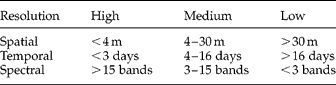
The number of satellites supporting communication, broadcasting and surveillance currently exceeds 900. Depending on the orbit, they are either geosynchronous (geostationary) or sun-synchronous (polar-orbiting). The former group, orbiting at a height of 36,000 km, is dedicated to mainly communication and meteorological applications and includes the Geosynchronous Orbiting Environmental Satellites launched by the National Oceanic and Atmospheric Administration (NOAA). However, to provide data from the whole planet, the satellites need to pass over the polar regions, relaying back ever-changing, longitudinal sweeps. These satellites generally follow elliptical orbits between 681 and 915 km above Earth's surface, each rotation taking about 100 min with a ‘revisit’ period between 1 and 41 days. In addition, to produce useful information from an epidemiological point of view, the sensors must be capable of producing high-resolution images, yet be able to also show large areas at different wavelengths. In fact, the resolution capabilities (spatial, temporal and spectral) effectively limit data collection since a high spatial resolution is associated with a low spectral resolution and vice versa (table 1). Therefore, a best-case compromise between the different resolutions according to the individual application must be found.
Classification of the information collected by sensors on-board satellites.
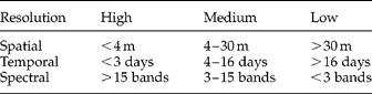
Spatial resolution corresponds to map scale and detail, while the spectral resolution is defined as the width of the electromagnetic spectrum read by the sensor. The temporal resolution is the period it takes for the satellite to revisit a position and send an updated ‘view’.
Satellite technology has improved the representation and study of the Earth's surface enormously over the past few decades, generating a continuous and now almost complete field of observation at many different wavelengths and scales. The sensors permit calculation of vegetation indices, land surface temperatures, atmospheric and soil moisture, rainfall, etc. Among the vegetation indices, the most used is the normalized difference vegetation index (NDVI), defined as the difference between the visible (RED) and near-infrared (NIR) bands over their sum, i.e. (NIR − RED)/(NIR+RED). It is a specific measure of chlorophyll abundance and light absorption, but its use can be extended to quantify herbaceous vegetation biomass, vegetation primary productivity, vegetation coverage and phenology, i.e. the study of periodic plant and animal lifecycle events and how these are influenced by seasonal and inter-annual variations.
Land cover classification refers to the natural vegetative cover, topography, soil or local climate. It also refers to the description of land use (crops, lying fallow, irrigated, etc.) and human settlements such as cities, rural areas, roads and other infrastructures (Herbreteau et al., Reference Herbreteau, Salem, Souris, Hugot and Gonzalez2005). The corine land cover (CLC) is a map of the European landscape with a spatial resolution of 100 m. It is based on visual interpretation of widely used satellite images (Satellite Pour l'Observation de la Terre, SPOT; Landsat, etc.). Ancillary data, i.e. aerial photographs, topographic or vegetation maps, statistics and local knowledge were used to refine interpretation and the assignment of the territory into 44 different classes (see CLC version 8/2005, European Environment Agency, http://www.eea.europa.eu/quicklinks/explore-interactive-maps/corine-land-cover-clc-data-download). The land cover categories are organized hierarchically into three levels:
(1) level 1 consists of the main land cover and land use categories, i.e. artificial areas, agricultural areas, forests/semi-natural areas, wetlands and water bodies;
(2) level 2 (consisting of 15 classes) covers physical and physiognomic entities at a higher level of detail, e.g. urban zones, forest types, lake types, etc.; and
(3) level 3 (consisting of 24 classes) is differentiated into subcategories based on further, less pronounced details.
Most developed and developing countries also have governmental programmes for aerial surveys, but these campaigns are not reproduced on a regular time basis and the ground coverage is often limited to areas of discreet interest. However, aerial photography should be considered as a supplementary source of information (Herbreteau et al., Reference Herbreteau, Salem, Souris, Hugot and Gonzalez2005).
Satellites and sensors
NOAA's Landsat satellites have collected spectral information from Earth's surface since 1972, resulting in an unmatched archive of spatio-temporal coverage. The Landsat programme consists of a series of satellite missions jointly managed by NASA and the US Geological Survey, and it can be said that RS science originated and matured with this initiative. Its sensors have a moderate spatial resolution, which is coarse enough for global coverage, yet detailed enough to characterize human-scale constructions. The multi-spectral scanner and thematic mapper are the most useful sensors for epidemiological approaches. Landsat-7, the latest satellite in this series, has eight spectral bands with a spatial resolution ranging from 15 to 60 m and was launched on 15 April 1999. The next one, the Landsat Data Continuity Mission, is scheduled to be launched in 2011 (http://landsat.gsfc.nasa.gov/about/index.html).
The advanced very high resolution radiometer (AVHRR) is a radiation-detection imager able to determine the temperature of cloud covers and surfaces such as land, water or the upper surfaces of clouds at a 1.1 km resolution. The first AVHRR was a four-channel radiometer, first carried on the TIROS-N satellite, launched in October 1978. The current version is the six-channel AVHRR/3, launched on-board NOAA-19 in February 2009. This array permits multi-spectral analysis for more precisely defining hydrologic, oceanographic and meteorological parameters. Comparison of data from two channels can be used to observe features or measure various environmental parameters. The three infrared channels are used to detect heat radiation from various surfaces, including clouds.
The French SPOT is a high-resolution, optical imaging satellite system operating since 1986. SPOT primarily explores Earth resources, but also supports studies of the climate, the oceans, human activities and natural phenomena (http://en.wikipedia.org/wiki/SPOT_satellites). The programme was initiated by the French space agency, Centre National d'Etudes Spatiales, and developed in association with the Belgian Scientific, Technical and Cultural Services and the Swedish National Space Board. The SPOT system also includes ground control resources for satellite control and programming, image production and distribution, which is run by ‘Spot Image’, an institution based in Toulouse, France. SPOT 5, the latest satellite in the series, has multi-spectral picture resolution capabilities of 10, 5 and 2.5 m.
Terra constitutes the first satellite in the international Earth Observing System (EOS) Program, which is a major component of the Earth Science Division of NASA's Science Mission Directorate. EOS is a coordinated series of polar-orbiting, low-inclination satellites permitting observations of land cover, biosphere, atmosphere and the oceans. On 24 February 2000, Terra began collecting what will ultimately become a new, 15-year global set of data, eventually to represent Earth as an integrated system. The satellite carries a payload of five remote sensors designed to monitor the state of Earth's environment and ongoing changes in its climate systems (http://terra.nasa.gov/About/).
Terra has been joined by a ‘twin’ satellite, Aqua, the first of a fleet of seven satellites flying in a formation called the ‘A-Train’ (http://csc.gallaudet.edu/soarhigh/A-TrainExplain.html) designed to collect data on climate parameters believed to be important for the balance of the climate. The A-Train formation provides coordinated measurements, i.e. data from several different satellites are used together to obtain comprehensive information about atmospheric components and processes (table 2).
Some basic information on the satellites of the A-train constellation used for the study of Earth's climate.

a Launch failed and the satellite was lost.
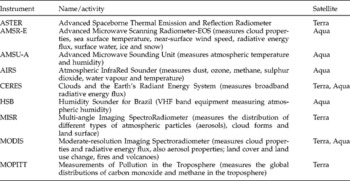
The moderate resolution imaging spectroradiometer (MODIS), an instrument of great utility for biological research, is the key instrument onboard both Terra and Aqua. Terra's orbit around the Earth is timed so that it passes from north to south across the equator in the morning, while Aqua passes south to north over the equator in the afternoon. In this way, an unusually high temporal resolution is obtained without loss of image quality. MODIS is one of the most useful multi-purpose sensors as it acquires data in 36 spectral bands, or groups of wavelengths, from the entire surface of the Earth every 1–2 days. Table 3 summarizes the type of sensors and focus of data collection of the Terra satellite and the A-train constellation.
An overview of the more important sensors on-board Terra and the A-train satellites.

The launch on 24 September 1999 of the IKONOS remote-sensing satellite by the US company ‘Space Imaging’ marks the beginning of high-resolution imagery for public and private industry worldwide. The integrated imaging payload enables IKONOS to collect panchromatic (black and white) images at 1 m resolution and multi-spectral data at 4 m resolution. The ITT imaging sensors onboard the satellite capture imagery across an 11 km swath of the Earth's surface. Once an image is obtained, a digital processing unit compresses and formats the digital imagery for transmission to Space Imaging's ground stations located throughout the world (http://en.wikipedia.org/wiki/IKONOS).
QuickBird constitutes the next step in visible, high-resolution surface scanning. This satellite, launched on 18 October 2001, as the first of a planned constellation of three, orbits in a 450 km altitude, − 98° inclination, sun-synchronous orbit. QuickBird has the largest image size and the greatest on-board storage capacity of any current satellite. It collects panchromatic imagery at 60–70 cm resolution and multi-spectral imagery at 2.4 and 2.8 m. At this level, buildings and other man-made structures are clearly visible. The imagery can be imported into RS image-processing software, as well as into any other GIS package, for analysis. Quickbird's owner is ‘DigitalGlobe’ (http://en.wikipedia.org/wiki/DigitalGlobe), a US commercial company whose customers range from urban planners to US federal agencies. For example, much of the high-resolution imagery of Google Earth and Google Maps is provided by DigitalGlobe.
DigitalGlobe also owns the WorldView-1 satellite, built by the US company ‘Ball Aerospace’ and launched on 18 September 2007. This satellite has a camera with a panchromatic, 50-cm maximum resolution capability onboard. It is currently the most powerful satellite with regard to spatial resolution. However, Ball Aerospace is currently finalizing WorldView-2, the next satellite in the series, which is scheduled for launch on 6 October 2009 (http://www.spaceflightnow.com/news/n0701/07worldview2/). It will include a panchromatic sensor with a 46-cm maximum resolution and also a multi-spectral sensor of 184-cm resolution.
Spatio-temporal modelling
In recent years, spatio-temporal modelling has become one of the most interesting, and also challenging, research areas in epidemiology and environmental health. The relevant literature is growing fast and along directions that span theoretical work, methodological development and field application (Angulo & Ruiz-Medina, Reference Angulo and Ruiz-Medina2008). For the vector-borne diseases in particular, the spatial and temporal characteristics of natural transmission play an important role as even minute variations in temperature and rainfall result in almost immediate changes in their distribution (Liang et al., 2007). As a consequence, spatio-temporal modelling is increasingly applied for a wide variety of arthropod- and snail-borne diseases affecting humans, livestock and other animals, e.g. dengue (Pongsumpun et al., Reference Pongsumpun, Garcia Lopez, Favier, Torres, Llosa and Dubois2008), leishmaniasis (reviewed in Ready, Reference Ready2008), malaria (Mabaso et al., Reference Mabaso, Vounatsou, Midzi, Da Silva and Smith2006), Rift Valley fever (Vignolles et al., Reference Vignolles, Lacaux, Tourre, Bigeard, Ndione and Lafaye2009), bluetongue (Racloz et al., Reference Racloz, Venter, Griot and Stärk2008) and schistosomiasis (Wu et al., Reference Wu, Wang, Utzinger, Yang, Kristensen, Bergquist, Zhao, Dang and Zhou2007).
Applications also include historical epidemics. For example, the spatio-temporal evolution of bubonic plague in India 1896–1906 has been studied using stochastic concepts and GIS techniques (Yu & Christakos, Reference Yu and Christakos2006).
Virtual globes
The idea of a virtual globe may first have been concocted in the science fiction literature. In this story (Stephenson, 1992), a piece of software called Earth was used for keeping track of a repository of geospatial data such as maps, weather and satellite surveillance data. Reality rapidly caught up as Microsoft first released an offline virtual globe (Encarta Virtual Globe 98) five years later, followed by the first online globe by NASA World Wind (http://www.worldwindcentral.com). Although several virtual globes of different origins are now available, ‘Google Earth’ (http://www.google.earth.com) currently dominates this market. This ultimate artificial representation of the world can be defined as a virtual, computer-based model of the Earth (or another world), where the user can freely change viewing angle and position. Compared to conventional world maps, virtual globes have the capability of presenting a multitude of different views related to the surface, including useful information. The views can show geographical features and man-made features (roads, buildings, etc.), and the information can consist of quantitative datasets regarding demography, economy or any other measure.
The literature on virtual globes is growing rapidly. An overview of the developments in this field during the past decade shows that possible uses for this new form of representation of the world are almost endless (Elvidge & Tuttle, Reference Elvidge and Tuttle2008). Although most applications are general-purpose applications with limited analytic functions, they cannot replace professional GIS software in any way. However, virtual globes are still useful as a complement to traditional GIS, and it is therefore not out of place to list some of what is available besides NASA World Wind and Google Earth:
(1) ‘ArcGIS Explorer’ – an application produced by ESRI (Redlands, California, USA) (http://www.esri.com/software/arcgis/explorer/index.html) intended as a client for the ‘ArcGIS Server’.
(2) EarthBrowser – a Flash/Adobe (http://www.earthbrowser.com) Automated image registration-based virtual globe with real-time weather forecasts, earthquakes, volcanoes and webcams.
(3) Poly9 FreeEarth – a cross-browser, cross-platform 3D globe claimed to be one of the lightest, most compatible of the 3D globes available on the Internet (http://www.freeearth.poly9.com/).
(4) Marble – a free, editable map of the world aimed for exchange of data from anywhere on Earth in a virtual globe environment. It is part of the K Desktop Environment project (http://www.kde.org) using data from OpenStreetMap (http://www.openstreetmap.org) as well as from NASA Blue Marble Next Generation and others. It can be used as a standalone application as well as a component in other applications.
(5) Microsoft Virtual Earth 3D – a virtual globe inside Internet Explorer (http://www.microsoft.com/virtualearth/) which uses data from NASA Blue Marble Next Generation.
(6) MacKiev's 3D Weather Globe and Atlas – a near-real-time cloud coverage and weather forecast globe from Software MacKiev's 3D Weather Globe and Atlas (http://www.mackiev.com/globe) that also provides time zones and day/night views from a database of 40,000 locations. The application requires Internet connection only for online features: satellite cloud cover and real-time weather and forecast data. It is based on the 1 km resolution Blue Marble imagery.
Google Earth and World Wind permit saving a cache of downloaded imagery to the user's hard disk, enabling previously accessed areas to be viewed offline. Google Earth, however, must be activated by first logging into its server and its cache size is limited to 2000 MB, whereas World Wind has no limit on cache size. World Wind also comes with the complete 500 m resolution Blue Marble imagery and global place names including countries, capitals, counties, cities, towns and historical references in addition to the downloaded images. It is also capable of displaying MODIS imagery from the Jet Propulsion Laboratory's Aqua and Terra satellites. Both Google Earth and Virtual Earth 3D are capable of displaying a multitude of urban areas in high-resolution, thanks to their private image sources. Both companies also acquire and use aerial images through flights over major cities. Virtual globe technologies are essentially web-based GIS tools, which bring some of the functionality of applied GIS to the non-specialist. Recent advances in the development of virtual globe technology provide an opportunity for a relatively inexpensive, more accessible method to communicate epidemiological data more effectively to non-specialists (Stensgaard et al., Reference Stensgaard, Saarnak-Larsen, Utzinger, Vounatsou, Simoonga, Mushinge, Rahbek, Møhlenberg and Kristensen2009).
Novel applications
Ecological analysis
The main application field of GIS in veterinary and public health is the epidemiological one, which benefits from the capability of GIS to integrate different databases into one environment. Many papers have been published on the analysis of the relationship between disease indicators (e.g. positivity, incidence and prevalence) and the environmental and climatic variables that might explain their values (Herbreteau et al., Reference Herbreteau, Salem, Souris, Hugot and Gonzalez2005). This type of analysis is based on a statistical procedure and targets the description of relationships existing between the geographic distribution of diseases and environmental risk factors (Kistemann et al., Reference Kistemann, Dangendorf and Schweikart2002). As suggested by Cringoli et al. (Reference Cringoli, Rinaldi, Veneziano and Musella2005) and Rinaldi et al. (Reference Rinaldi, Musella, Biggeri and Cringoli2006), the following fundamental steps should be utilized when pursuing ecological analysis:
(1) construction of a GIS for the study area utilizing data layers delineating environmental and climate features;
(2) establishment of a geo-referenced frame for the geographic units of interest;
(3) creation of buffer zones of a given diameter centred on the geo-referenced points;
(4) extrapolation of values for each environmental feature within each buffer zone;
(5) production of a database with environmental and parasitological data; and
(6) statistical analyses (univariate, multivariate, etc.) to detect environmental risk factors and/or to develop forecast models.
Apart from the administrative boundaries, the most commonly used environmental and climate features in the data layers for ecological analysis in veterinary epidemiology are the NDVI, land cover, land use, elevation, slope, aspect, lithofacies, lakes, rivers and other water bodies, temperature, rainfall and humidity. Usually, once this information has been obtained, the ecological analysis is carried out by associating the disease data with the environmental characteristics extracted within the buffer zones constructed around the geographic unit(s) of interest (Cringoli et al., Reference Cringoli, Rinaldi, Veneziano and Musella2005; Rinaldi et al., Reference Rinaldi, Musella, Biggeri and Cringoli2006; Pozio et al., Reference Pozio, Rinaldi, Marucci, Musella, Galati, Cringoli, Boireau and La Rosa2009).
Spatial statistics
A framework of spatial statistics of epidemiological data includes data visualization, exploratory analysis and modelling (Pfeiffer, Reference Pfeiffer, Durr and Gatrell2004). With respect to data visualization, maps based on raw data are generally unstable since the observed differences in disease occurrence between areas are difficult to interpret. The reason is that they derive from the sum of true, structural differences, but also of the ‘noise’ in the sampling process. This problem is well known in human epidemiology and several statistical analyses have been proposed to filter out the noise from the signal (Elliott et al., Reference Elliott, Wakefield, Best and Briggs2000). Some of these techniques have also been used in veterinary medicine, e.g. regarding fasciolosis (Durr et al., Reference Durr, Tait and Lawson2005), paramphistomosis (Biggeri et al., Reference Biggeri, Catelan, Rinaldi, Dreassi, Lagazio and Cringoli2005), echinococcosis (Berke, 2001; Budke et al., Reference Budke, Jiamin, Craig and Torgerson2005), bovine spongiform encephalopathy (BSE) (Abrial et al., Reference Abrial, Calavas, Jarrige and Ducrot2005), dicrocoeliosis and haemonchosis (Biggeri et al., Reference Biggeri, Catelan, Dreassi, Rinaldi, Musella, Veneziano and Cringoli2007), mastitis (Green et al., Reference Green, Burton, Green, Schukken, Bradley, Peeler and Medley2004), and foot and mouth disease (Lawson & Zhou, Reference Lawson and Zhou2005).
Risk mapping and modelling
Knowledge of the prevailing climate and environmental characteristics of an area, which can be provided by GIS and RS, can help in predicting disease seasonality by comparing this information with the known requirements of the species under study. Climate-based forecast systems have been developed using the concept of growing degree days (GDD), a heuristic tool in phenology first used by horticulturists to predict the date that a flower will bloom or a crop reach maturity. GDD are calculated by taking the average of the daily maximum and minimum temperatures compared with a base temperature, T base, using the equation GDD = (T max+T min)/2 − T base. When applied to parasites whose growth is also strongly influenced by the ambient temperature, the GDD concept can be useful in predicting risk and in deciding on disease intervention. GDD have been applied to fasciolosis, schistosomiasis, malaria (Malone, Reference Malone2005) and dirofilariasis (Genchi et al., Reference Genchi, Rinaldi, Cascone, Mortarino and Cingoli2005).
Modelling of spatial data aims to explain or predict the occurrence of disease. Since the spread of human and animal epidemics depends on the characteristics of the environment, spatio-temporal information such as temperature, humidity, vegetation, hydrology, general meteorology, etc. can be used together with clinical data to construct predictive mathematical models. This information can assist with the assessment of the distribution of health-relevant environmental factors via interpolation. Predictive maps can be obtained by application of: (1) heuristic statistical algorithms (similar to a neural network); (2) standard frequentist statistical approaches (extensions of regression modelling, linear discriminate analysis in the case of multivariate data or a generalized linear mixed model in the case of an unmeasured source of variability); or (3) Bayesian statistical approaches (e.g. the Markov Chain Monte Carlo technique). A description and review of veterinary applications of these techniques have been provided by Pfeiffer (Reference Pfeiffer, Durr and Gatrell2004).
Surveillance and EWS
A disease surveillance system is an integrated set of planned epidemiological measures aiming at the identification and prevention of new cases. A basic requirement is the capability to transfer new information with regard to a disease in the population under control. Traditionally, data flows are activated by an alert with activities following predetermined action rules established by specialized agencies set up to survey and control infectious diseases. The time lines in reporting, as well as the sensitivity and specificity of the system, are critical. Where rapidity of reporting is of primary importance, the surveillance system requires features such as special sensitivity for the identification of possible new cases of disease, or any variation on the ‘natural’ rate of their occurrence. Thus, surveillance has characteristics that are independent from the techniques used to collect cases, an aspect that becomes evident when considering the geographical dimension of the phenomenon and where surveillance aims to monitor discontinuities in the spatial rate of a disease. The process that generates cases of disease is heterogeneous, i.e. the frequency of disease is not spatially uniform but proportional to the number of people at risk. The difficulty in interpreting clusters of cases of disease lies in the appreciation of whether to attribute them to an epidemic or to a minor alteration in the occurrence of the disease in question (Elliott et al., Reference Elliott, Westlake, Hills, Kleinschmidt, Rodrigues, McGale, Marshall and Rose1992; Aylin et al., Reference Aylin, Maheswaran, Wakefield, Cockings, Jarup, Arnold, Wheeler and Elliott1999).
Once the spatial distribution of the population at risk is available, the natural rate of occurrence of the phenomenon under study should be collected. This can be done through finding the risk under ‘normal’ conditions by the production of a statistical estimate including the standard error of the frequency of the disease, which becomes the reference rate. Alternatively, the information is taken from the literature. However, this requires not only that the natural rate of disease is constant over the territory under control, but also access to a database of published papers and the capability to perform a critical appraisal of the evidence. Indeed, quality and reliability of scientific information depend on study design, techniques of data collection and analysis and characteristics of the studied populations. Such information cannot always be immediately extended to the particular context of the local surveillance system.
A surveillance system is essentially an expert approach in which the basis for impact assessment is derived from the reference information represented by the number and distribution of expected cases. The system assists in evaluating spontaneous claims or data arising from routine scans by applying appropriate statistical modelling. From a general point of view, a geographical surveillance epidemiological system should be composed of:
(1) knowledge of the natural history of the disease;
(2) availability of effective preventive means;
(3) presence of an information system to detect new cases of disease;
(4) a GIS and the acquisition of satellite images and ecological indices;
(5) availability of aerial photography;
(6) geo-referencing of the population at risk;
(7) statistical modelling and mapping of expected number of cases; and
(8) retrieval and critical appraisal of the scientific literature.
GIS applications lend themselves to the development of EWS needed to permit pre-emptive planning to limit risk and impact of new diseases and infectious agents. Biology-driven models, in particular, have the potential of assessing current and future risk patterns for vector-dependent parasitic infections. The early identification of an epidemic is an important first step towards implementing effective interventions to control the disease and reduce the resulting impact on humans and/or animals (Estrada-Peña et al., Reference Estrada-Peña, Vatansever, Gargili and Buzgan2007). According to the EMPRES Expert Consultation (1996), EWS are defined as all initiatives leading to improved awareness and knowledge of the distribution of disease or infection, and that might permit forecasting of the further evolution of an outbreak.
The ready availability of frequently updated data on environmental variables pertinent to vector-borne disease transmission over large and remote regions makes GIS and RS useful resources for the development of epidemic EWS (Ceccato et al., Reference Ceccato, Connor, Jeanne and Thomson2005).
EWS and accurate forecasting of new outbreaks of epidemic livestock diseases may also affect wildlife. The capacity for spread of such diseases to new areas is an essential prerequisite to their effective containment and control (Martin et al., Reference Martin, De Simone, Lubroth, Ceccato and Chevalier2007).
Global warming and environmental monitoring
In recent years, several vector-borne diseases have (re-) emerged and spread due to global and/or local changes that have led to the invasion of new arthropod vectors, the improvement of vector capacity or to the introduction and establishment of new pathogens (Hendrickx et al., Reference Hendrickx, Biesemans, de Deken, Durr and Gatrell2004; Rogers & Randolph, Reference Rogers and Randolph2006). In particular, global warming would extend the risk season for infection and to maintain a high incidence level. This is important in evaluating the correct timing for preventive treatment, which must ensure protection from infection during the entire risk season.
In addition to climate changes, other important drivers for the (re)-emergence and spread of vector-borne parasites include habitat changes, alterations in water storage and irrigation habits, pollution, development of resistance to insecticides and drugs, globalization and the increase in international trade, tourism and travel (Harrus & Baneth, Reference Harrus and Baneth2005). Babesiosis, bluetongue, chikungunya, dengue, encephalitis, ehrlichiosis, leishmaniasis, Lyme disease, malaria, plague, trypanosomiasis, West Nile disease and yellow fever are examples of vectorborne diseases that are affected by climate changes and the above-mentioned drivers (Takken & Knols, Reference Takken and Knols2007).
Novel trends in application
Unexpectedly, GIS can also be applied for orientation at the cellular level. In an approach reminiscent of GIS-supported mapping, stacks of laterally ‘stitched’ individual photographed images covering the entire area of a microscopic sample are available for ‘navigation’, not only in the x-axis and y-axis but also in the z plane, i.e. it is possible to change the focal plane since specimens were scanned and photographed in several focal planes (Linder et al., Reference Linder, Lundin, Thors, Lebbad, Winiecka-Krusnell, Helin, Leiva, Isola and Lundin2008). The complete digitized image information, amounting to about 10 GB uncompressed data per specimen, is accessible in the form of a ‘webmicroscope’ on the computer screen at transfer speeds varying from 2 to 10 MB/s over the Internet (http://www.webmicroscope.net/parasitology).
GIS has also been used for clinical research. Knowledge of location in the context of anatomic relationships is important for optimizing and limiting the time of operative intervention. Ganai et al. (Reference Ganai, Garb, Kanumuri, Rao, Alexander and Wait2006) developed a GIS-based approach to find the position of lesions selected for transanal endoscopic microsurgery. They applied and carried out spatial analysis accounting for regional position and clustering of lesions. It was found that regional characteristics, significantly associated with operative time, included distance, presence of cancers and positive margins. Peritoneal breach was strongly associated with lesion size and location, while conversions were associated with distance.
Conclusion
The development of improved hardware, software and network technology, as well as the widespread use of the Internet for exchange of information, has created the prerequisite for a broad acceptance of GIS and RS within the epidemiological sciences. Disease mapping and environmental risk assessment using digital geospatial data resources are now established analytical tools in both human and veterinary public health. Indeed, spatial epidemiology is defined as a subdiscipline of epidemiology, the primary purpose of which is to describe and explain the spatial patterns of disease.
Infectious agents are bound to environments characterized by features that satisfy their specific requirements, and the chance of the organisms rapidly adjusting to, for example, the changing climate is limited. This is particularly true for parasites relying on intermediate hosts, as their life cycles involve many steps that all have to be adjusted for the parasite to survive. This line of enquiry depends strongly on RS from satellites observing the Earth's surface and measuring critical values, e.g. temperature.
For the satellites to produce useful information, the sensors on-board must be capable of producing high-resolution images at different wavelengths. Since a high spatial resolution is associated with a low spectral resolution and vice versa, data collection must be adjusted to each individual application. Disease surveillance systems and EWS are prime examples of systems with an immediate practical application, while the construction of virtual globes for epidemiological research has just started and its role can only grow from here.
The potential of the approaches mentioned above, ‘webmicroscopy’ and clinical applications, is clearly far-reaching. Further developments and applications in these areas alone will soon be mainstream, while novel and unexpected applications of GIS are certain to increase further.