


Introduction
Internal colonisation of rural areas has always represented an important research subject not only for geographers but also for historians, economists and sociologists.Footnote 1 Several studies concerning colonisation of vast and fertile regions, based on a diversity of sources and various methodologies, have been published.Footnote 2 In Romania, a small number of studies researched the dynamics of the agrarian legislation, land ownership and the colonisation of less inhabited areas.Footnote 3 In addition, the results of the agrarian laws adopted at the end of the nineteenth century and their impact on the process of internal colonisation have never been fully understood.
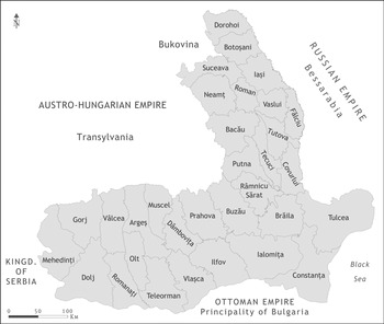
After the creation of the United Romanian Principalities in 1859, a series of modernising reforms were passed under the rule of Prince Alexandru Ioan Cuza.Footnote 4 Among the most important ones were the secularisation of monastic estates, followed by the abolition of corvée, in 1864.Footnote 5 The agrarian reform from 1864 granted private properties to more than 400,000 families of peasants who became owners of one third of the country’s arable land. Following the appropriation for the newlyweds, which took place between 1878 and 1882, approximately 48,000 families received 230,000 hectares of land.Footnote 6 This could be considered the first official project of colonising less inhabited but fertile areas of the Romanian Kingdom (Figure 1).Footnote 7
Romanian Kingdom in 1881. Cartography: Theodor Cepraga.

In the last decades of the century, population growth was soon accompanied by an increase in demand for agricultural land because the big landowners and the state continued to own 70 per cent of the country’s arable land.Footnote 8 Most of the peasants did not have sufficient land and pasture to achieve economic independence. In order to survive, they had to work on the estates of their former landowners under harsh terms, which was described at that time as ‘neo-serfdom’.Footnote 9
The state wanted to improve the condition of the peasantry in order to reduce the growing frustration of the rural population. As a result, in 1881 and 1889, two laws concerning the sale of the state-owned estates were enacted.Footnote 10 The intention was to sell small plots of land to the peasants so that they could gain more economic independence. The sale of land was soon followed by the creation of new settlements in low populated but fertile areas of the country, a process described at that time as internal colonisation. Even though information about the extent of land surfaces appropriated, the number of purchasers and the new villages were known at that time, the results of these laws have never been entirely explored, especially from a geographical perspective.
The current study focuses on the process of rural colonisation, which took place at the end of the nineteenth century as a result of the sale of state-owned estates. This article uses data extracted from official statistics, historical maps and archival documents to examine, from a spatial perspective, the colonisation of various regions characterised by low population density and proper conditions for agricultural development. The study analyses the spatial distribution of newly created villages, together with their characteristics and specific toponymy.
In its final part the article sheds new light on the results of the internal colonisation by exploring how the population responded to this process. It also takes into account the opinions asserted, at that time, by both politicians and rural sociologists.
Agrarian transformations in nineteenth-century Romania
In the second half of the nineteenth century, the Romanian Principalities of Wallachia and Moldavia experienced a series of political, economic and social transformations.Footnote 11 During the 1830s, under the protectorate of the Russian Empire, the quasi-constitutional laws called the Organic Statutes were enforced in both principalities. These regulations had an impact on the agrarian regime because they were designed to favour big landowners who were eager to benefit from free trade on the Danube. Therefore, the land of the corvée peasants depended on the amount of livestock they owned.Footnote 12
The creation of the United Romanian Principalities, in 1859, is often considered to be the birth of the modern Romanian state. This eventful moment opened the path to the implementation of numerous modernising reforms in the country.Footnote 13 One of the most contested issues was the reformation of the agrarian system.Footnote 14 In December 1863, the secularisation of the monastic estates was approved by the government, resulting in the transformation of approximately 25 per cent of the country’s territory into state-owned property.Footnote 15 Following years of harsh debates and a coup d’état, the agrarian reform, also known as the Rural Law, was finally sanctioned in August 1864.Footnote 16 It attempted to be a real milestone in the modernisation of the Romanian state by putting an end to serfdom and to medieval means of exploiting an estate.Footnote 17 The corvée peasants became owners of their lands, while the corvée, the tithe and all the monopolies of the boyars were abolished. More than 400,000 peasant families received approximately 1.8 million hectares of land. Other 60,000 families were given only household plots.Footnote 18 The transfer of property was surveyed by the state, which had to receive compensations, during the next 15 years, while the peasants could not alienate their lands over the next thirty years.Footnote 19
The agrarian reform from the Romanian Principalities was influenced by the implementation of similar reforms in the neighbouring regions.Footnote 20 In Transylvania, at that time part of the Habsburg Empire, serfdom was finally eliminated in 1848.Footnote 21 In the Russian Empire, which held Bessarabia, a reform that granted common property to peasants was passed in 1861.Footnote 22 The agrarian reform from 1864 impacted not only the distribution of land but also the evolution of social classes in rural areas.Footnote 23 However, the results of the reform were less effective due to several factors. The appropriated peasants could not achieve economic independence because the surface of land attributed to a family was far from sufficient.Footnote 24 Moreover, the inheritance practices, which granted each offspring a strip of land, led to an over-fragmentation of the original plots. Therefore, in the years that followed the reform, a large number of peasants were forced to accept onerous deals with their former landowners in order to survive.Footnote 25 The legislation concerning the agricultural agreements between landlords and peasants gave birth to an agrarian regime that favoured the creation of large properties, at the expense of the peasant-owned lands.Footnote 26 This led to the recurrence of the former relations between peasant and landowner, which was styled as ‘neo-serfdom’.Footnote 27
The implementation of two articles from the Rural Law concerning the appropriation for the newly married peasants was delayed for more than a decade. In 1878, when the articles were finally enacted, the law stipulated the endowment with lands from the state-owned estates for four distinct categories of peasants: the newlyweds from 1863 and 1864; peasants who, in 1864, received only a household plot; peasants who became proprietors of a surface smaller than what the Rural Law mentioned; and peasants who were recruited by the army at the moment of the enactment of the agrarian reform.Footnote 28
Between 1878 and 1882, 48,382 families of peasants were given roughly 230,000 hectares of land.Footnote 29 The vast majority of them also received household plots, which were located either in their villages or in some other newly established settlements.Footnote 30 The process of founding new villages on the public domains, which were sold to the newlyweds, aimed to decrease the agricultural pressure in highland regions and to populate less inhabited areas. This can be considered the first project of so-called internal colonisation.Footnote 31 Even though the appropriation for the newlyweds did not offer a solution to the rapid demographic increase and the growing social pressure in rural areas, it was the starting point of internal colonisation in Romania.Footnote 32
In the final decades of the nineteenth century, 85 per cent of the population was still living in rural areas. This means that more than five million peasants depended on agriculture in order to survive.Footnote 33 The economist G. D. Creangă described the land tenure as being ‘abnormal and hurtful’.Footnote 34 His arguments were based on statistics that showed that 95 per cent of the owners, meaning approximately one million families of peasants, owned properties smaller than ten hectares. At the same time, 5,385 landowners possessed almost 50 per cent of the arable land.Footnote 35 In the final decade of the nineteenth century, there were more than 400,000 landless peasants.Footnote 36
The outbreak of the peasant uprising in 1888 revealed once again the ongoing discontent of this social class.Footnote 37 In response, the state passed in 1889 a law that offered the possibility to peasants to buy land from the public domains.Footnote 38 It was not the first time the state sold a part of its estates. In the previous two decades, these transactions were motivated by a growing need for revenues in order to finance public works and, in that instance, the main purchasers were the big landowners. Peasants had the chance to buy small plots of land only in 1881, but the conditions of the transaction were too restrictive for them.Footnote 39 The 1889 law, concerning the sale of small plots from the public domains, was amended several times, in order to better suit the needs of the peasantry. It also continued the politics of internal colonisation, this time on a bigger scale. Although its implementation lasted almost two decades and its impact was far more important than the appropriation for the newlyweds, it is less studied and poorly understood. During the interwar period, the scientific literature was mainly focused on the impact of the then-recent agrarian reform of 1921 and the subsequent evolution of both landlords and peasants.Footnote 40 In the communist era, the accent was put on the emancipation of the corvée peasants during the nineteenth century and the oppression they had to face from the boyars. Though the literature concerning agrarian reforms and rural development is voluminous, the references to the laws concerning the sale of public lands are scarce.Footnote 41
Even today, the impact of this massive land distribution is poorly acknowledged. The general belief that every appropriation from the nineteenth century is linked to the agrarian reform of 1864, coupled with the lack of research into related archival documents has thrown this subject into oblivion. Moreover, the assessment of the process of internal colonisation, including the positive and negative opinions published by various writers at that time, have yet to be fully explored.
Data and methodology
The analysis of the legislation regarding the sale of public domains and its impact is very important for understanding the context in which internal colonisation took place. The methods used for this study involved the interpretation of statistical sources, archival documentation and cartographic analysis. The identification and geocoding of all the settlements founded as a result of the sale of public domains were conducted using several sources. The most important one was the official statistics compiled at the national level by the Ministry of Agriculture and Domains.Footnote 42 This document comprises the name of all newly founded settlements, together with the figures regarding the number of peasants who bought land on each estate and the number of the occupied and vacant household plots, until 1909. All the villages mentioned in the statistics were manually geocoded using three cartographic sources: Romanian Topographic Map (Harta Topografică a României),Footnote 43 Army Shooting Plans (Planurile Directoare de Tragere)Footnote 44 and Romanian Topographic Map, second edition (Harta Topografică a României, ediţia a II-a).Footnote 45
Several setbacks and obstacles made the research difficult, especially during the identification and geocoding of the newly founded villages. The data published in the official statistics contain many spelling errors, particularly on the toponymy of settlements. Moreover, many so-called new villages are in fact older settlements that have only been expanded following the sale of public lands. This fact, coupled with the changes in toponymy that took place during the last century, made the geocoding of several villages difficult. The absence of a Historical Geographic Information System (HGIS) for Romania was another setback in the attempt to eliminate the villages expanded following the sale of public lands, compared to the newly created ones.
The data was corroborated and validated using information extracted from The Statistical Dictionary of Romania, published in 1914.Footnote 46 Another validation was made for several areas with the help of historical documents,Footnote 47 but most of the archives were split between various regional branches of the National Archives. The processing and mapping of data were conducted using GIS. The main objective of this process was the construction of a spatial database and several thematic maps that could offer geographic information concerning this internal colonisation. A comparison between the results of the appropriation for the newlyweds and the sale of public estates was finally done in order to highlight the transformation that occurred in several rural areas at the end of the nineteenth century.
Enacting the sale of the state-owned estates
The last decades of the nineteenth century were characterised by sharp demographic growth, in the context of unparalleled political and economic stability in Wallachia and Moldavia.Footnote 48 The abolition of the corvée, together with the other privileges of the boyars, followed by the appropriation for the newlyweds, did not lead to a real improvement in living conditions for the vast majority of peasants. The population growth trigged, in a short span of time, an excessive fragmentation of the plots of land owned by the peasants.Footnote 49 In rural areas, between 1870 and 1880, a total number of 316,851 marriages were recorded.Footnote 50 This fact certifies the establishment of new households and the growing need for land for the peasantry.
In order to satisfy the demands of the villagers, on the 12th April 1881, the law concerning the sale of the state-owned domains was passed.Footnote 51 This represents the first law, which regulated the sale of public lands in small plots, to the peasants.Footnote 52 All the estates whose income did not exceed 20,000 lei per year and that did not have forests more extensive than 100 hectares were put up for sale. The price was equal to the value of the lease multiplied by fifteen. The buyers could purchase small plots of four, six or eight hectares, large plots of twenty-five, fifty, one hundred or one-hundred-and-fifty hectares, as well as whole estates that were sold only at auction. For the large plots and the whole estates, a quarter of the amount had to be paid within one month and the remaining sum in twenty-four years, with an interest rate of 6 per cent. Peasants buying small plots had to pay a fifth of the total value in the first month and the rest in the same conditions valid for the other types of plots.Footnote 53
The law was amended in 1884 when the surface of the small plots was limited to five hectares. The price equalled the annual lease multiplied by twenty, and it also had to be differentiated according to soil quality. Furthermore, it was impossible for a buyer to purchase more than two small plots. The modified law from 1884 contained several explanations regarding so-called internal colonisation. It stipulated that landless peasants, followed by those who owned less than five hectares, had priority in purchasing the land. When the number of buyers was of at least one hundred and the distance to school or church was too great, a new village had to be established. The expenses for the measurement and plotting of the land were borne by the peasants, while the state offered, for free, ten hectares for the school and the church.Footnote 54
A new modification of the law took place in 1886 when, in order to support the creation of new settlements, the authorities mandated that buyers of small plots must establish their residence on the purchased estate. The relocation had to be done within a maximum of three years, otherwise the land would return to the state. The peasants who bought land in the vicinity of their residence were exempted from this stipulation.Footnote 55
In 1888 peasants near Bucharest and from several counties in Moldavia rebelled. They were protesting against the harsh working conditions, but especially, against the lack of agricultural lands.Footnote 56 In order to appease the countryside, on 7th April 1889, the authorities adopted another law for the sale of state-owned domains.Footnote 57 This law eased conditions so that peasants could finally afford to buy land. At the same time, it was the most important measure taken by the state towards the creation of new settlements, thus continuing the policy of internal colonisation started in 1878.Footnote 58
All the public estates were up for sale in plots of five, ten, or twenty-five hectares. A householder could purchase only one small plot, which became inalienable for the next thirty years. The price was set at the value of the lease multiplied by twenty, and it was also differentiated according to the quality of the soil. The purchaser did not have to pay anything in advance and the interest rate was 5 per cent. The plots of ten and twenty-five hectares were sold only at auction, in the county of residence of the purchaser who had to pay a tenth of the price in the first month.Footnote 59 The law was amended in 1892, so that the price of land was classified into five categories, depending on the location of the estate. In mountainous areas, the minimum surface of the plot was reduced to 2.5 hectares, while the urban administrative units had the possibility to buy up to five small plots, in order to manage the future development of the cities.Footnote 60 The numerous demands made by the peasantry led to a new modification of the law, which occurred in 1896. From that moment on, the public estates were sold only in plots of five hectares, with an interest rate of 4 per cent. If four consecutive installments were not paid, the sale was cancelled without notice and without any possibility of appeal.Footnote 61
A plot of land of five hectares consisted of 2,000 m2 plot for the household, 2,500 m2 of pasture, 500 m2 occupied by roads and public institutions and 4.5 hectares of arable land, grouped into one or more parcels. When more than one hundred peasants wished to buy land in the same administrative unit, a topographical engineer had to determine the plan of the new village that was created. Together with the plan, the engineer would set the direction and the width of streets, the location of the city hall, church, hospital, school and cemetery. The price was distributed proportionally to each plot and had to be supported by the buyers. Moreover, the engineer was responsible for the tracing of other roads, which had to connect the newly established village to other settlements. If the household plots were located far away from any other village, or if they were placed on rough terrain, the plotting could be made, exceptionally, for fewer than one hundred purchasers.Footnote 62 All the persons who had bought land had to build their dwelling on the purchased property in no more than three years, but compared to the previous law, no sanctions were provided. The landless peasants and those with very small properties had priority when purchasing. Also, priority was given to the peasants who already lived on the estate that was up for sale, followed by those from neighbouring estates.Footnote 63
Results of the sale
Following the 1881 law for the sale of public lands and the subsequent modifications from 1884 and 1886, 4,970 families of peasants bought plots of land smaller than ten hectares, on a surface of approximately 23,000 hectares. At the same time, 1,716 well-off peasants acquired plots larger than ten hectares, on a surface of less than 8,200 hectares.Footnote 64 No settlements were established following the sale, because it was difficult for many buyers to front a fifth of the price at the purchasing. Therefore, only wealthy peasants, who were not interested in relocating to a new village, were able to purchase land.
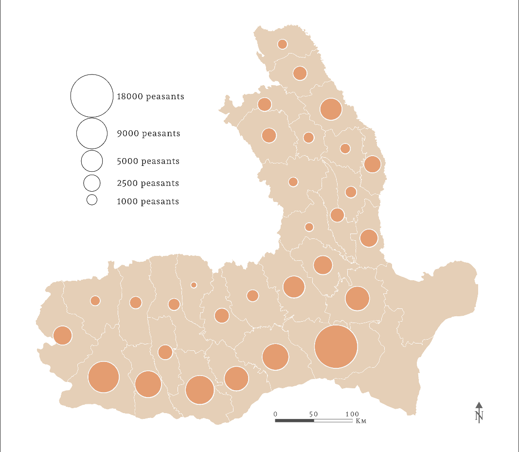
On the other hand, based on the law for the sale of state-owned domains from 1889 and its amendments, 105,165 families of peasants purchased plots of land smaller than ten hectares, on a surface of 526,000 hectares. Only 1,549 buyers could purchase plots larger than ten hectares, on a total surface of 20,360 hectares.Footnote 65 From a spatial point of view, as a result of the law from 1889, the largest number of small plots sold were in southern Wallachia. Those counties were renowned for their enormous public estates, but also for the numerous peasants who could afford to buy land (Figure 2).Footnote 66 In Moldavia, the number of peasants who bought land plots was slightly lower, compared to Wallachia. The largest number of purchasers happened in the counties of Iaşi, Covurlui and Fălciu due to their proximity to the trade route, which ran parallel to the border, towards the port city of Galaţi. In these counties, there were more than 15,000 families of well-off peasants who did not fulfil the corvée before 1864,Footnote 67 part of them having worked in transportation and trade activities.
The number of peasants who purchased small plots (five hectares) on the public domains, following the law from 1889. Cartography: Theodor Cepraga.

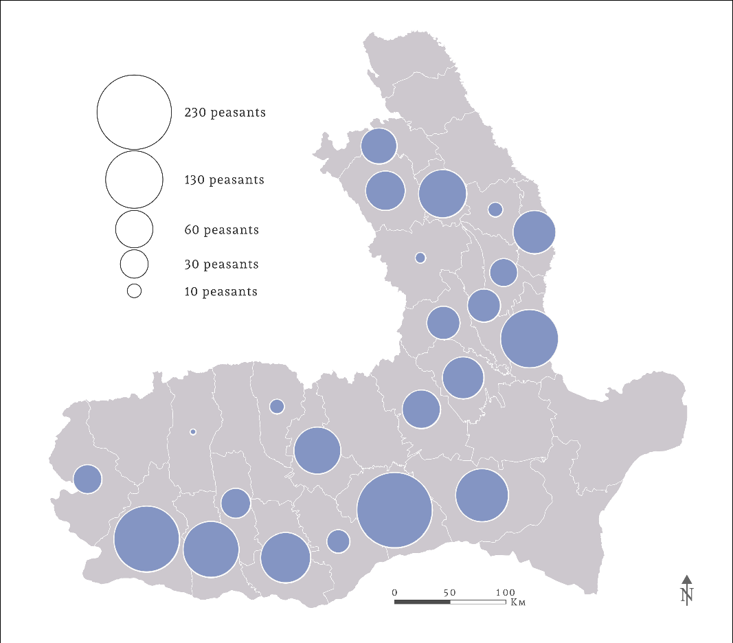
Buyers of large plots, of ten or twenty-five hectares, exceeded the threshold of one hundred only in a few counties (Figure 3).Footnote 68 Based on this statistic, the regions of the country where peasants had the financial means to develop their agricultural production can easily be identified. In Wallachia, most of the larger plots were sold in the plain region, as in the case of small plots. In Moldavia, the first places were held again by the counties of Covurlui and Fălciu, followed by Roman, Neamţ and Suceava, where vast domains, formerly belonging to monasteries, were sold by the state in large plots.
The number of peasants who purchased large plots (ten or twenty-five hectares) on the public domains, following the law from 1889. Cartography: Theodor Cepraga.

The newly established settlements
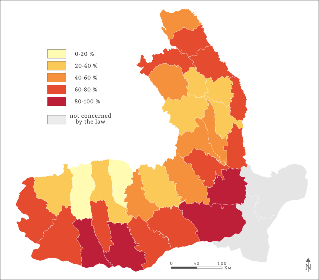
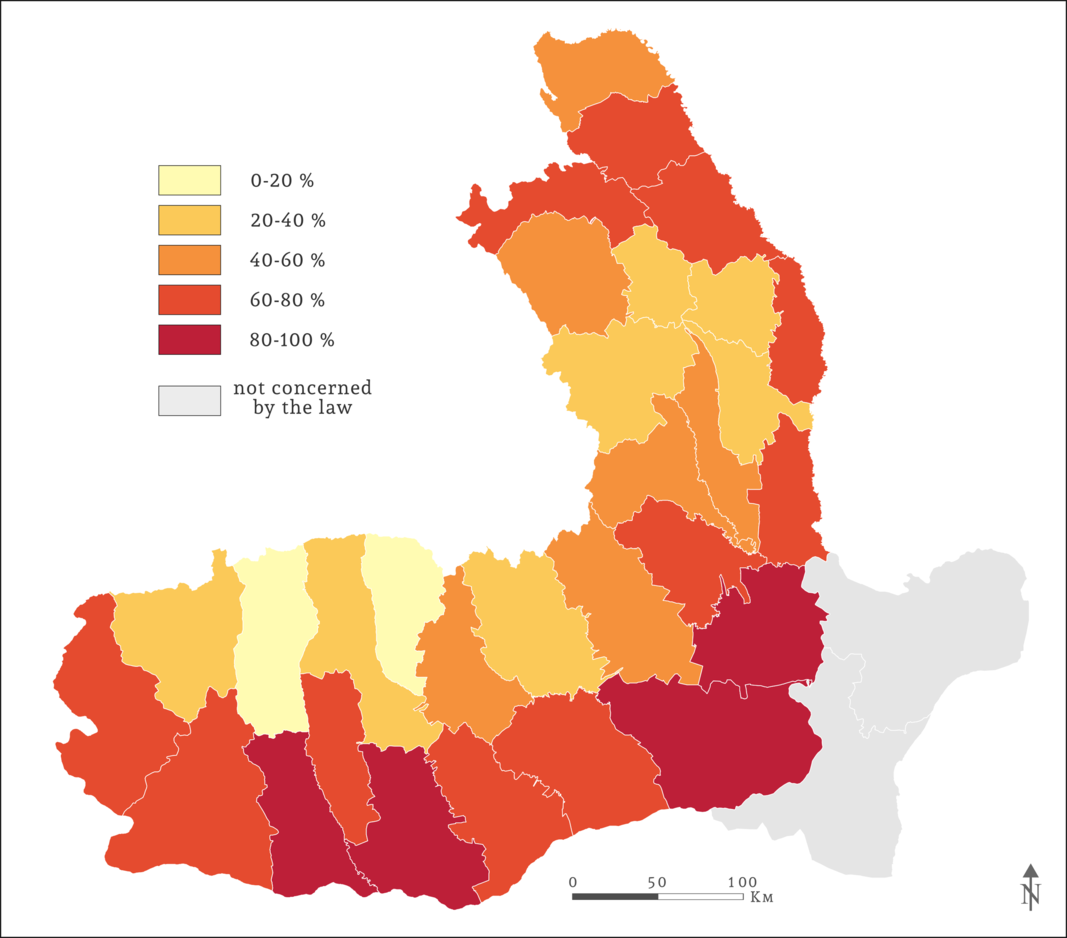
The main purpose of the laws concerning the sale of the state-owned domains was to provide a minimum area of land to peasants so that they could earn their living independently. The second objective of this endeavour related to so-called internal colonisation. The laws indicated the possibility of setting up new settlements on public estates, in order to populate the least inhabited areas that were favourable to agriculture development. Based on the law from 1889 and its subsequent amendments, a total number of 79,783 families of peasants were given a household plot together with agricultural land.Footnote 69 This represents approximately 70 per cent of the total number of the purchasers. In Wallachia, in the counties of Brăila, Ialomiţa, Teleorman and Romanaţi, which comprised vast uninhabited areas, more than 80 per cent of the purchasers were given a household plot (Figure 4).Footnote 70 High percentages were recorded in southern Wallachia, in Râmnicu Sărat County, but also in Moldavia, in the counties of Suceava, Iaşi, Botoşani, Fălciu and Covurlui. The figures are surprising for Suceava and Fălciu Counties because most of their territory is over hilly terrain. In Vâlcea and Muscel Counties, from Wallachia, less than 20 per cent of the peasants who bought land were given a household plot, due to the high density of inhabitants in the Subcarpathians.
Percentage of the total number of purchasers who received a household plot. Cartography: Theodor Cepraga.
The official statistics, published in 1909 by the Ministry of Agriculture and Domains, show that, following the process of colonisation, 357 new settlements were established in the Kingdom of Romania, except for Dobrudja, which was not covered by the law.Footnote 71 Detailed research of the information presented in the statistics revealed that only 274 villages were created, while the built up area of the other seventy-seven older settlements was merely extended on this occasion. At the same time, some six new villages could not be identified, most probably because they were never established. The validation of the exact number of newly created settlements was conducted using GIS and other information extracted from historical maps, statistical dictionaries and archival sources.
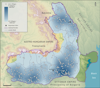
The results of the spatial analysis concerning the location of the newly created settlements reveal the existence of three principal nuclei (Figure 5). The area with the highest density of new villages was located in the south-eastern part of Wallachia, at the limit of Ialomiţa and Ilfov Counties. The second most important region was in Moldavia, at the contact between the plain and hilly regions, on the territory of Iaşi, Suceava and Roman Counties. The third highest density was in south-western Wallachia, split between Dolj and Romanaţi Counties.
The spatial distribution of the newly created villages after the sale of the state-owned estates. Cartography: Theodor Cepraga.
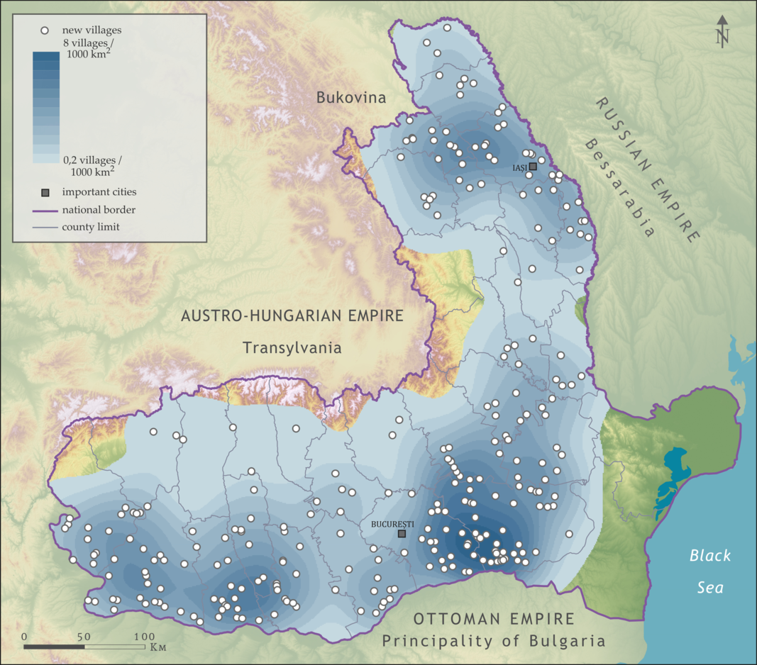
The densities of up to eight villages per 1,000 km2 recorded in south-eastern Wallachia’s plain region could be explained by the fact that until the colonisation, the majority of the settlements were located near the Danube or Ialomiţa River. The vast plains, which before 1863 were in the property of various monasteries from Wallachia, became the most suitable terrain for the establishment of new villages. Regarding Moldavia, the sale of public lands followed by the creation of new settlements continued a process that began with the appropriation for the newlyweds, in 1878. A particularity of the 1889 law was the sale of numerous estates located in the plateau region. Even though they were not very suitable to cropping, compared to the ones from the plains, they were largely uninhabited and close to the mountain regions where many peasants did not have enough land. In south-western Wallachia, the new villages were established on the estates previously owned by the monasteries from the Subcarpathians and Bucharest. The process that started with the appropriation for newlyweds in the Romanaţi County was now extended to Dolj, particularly along the Danube’s fertile lands.
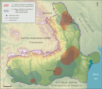
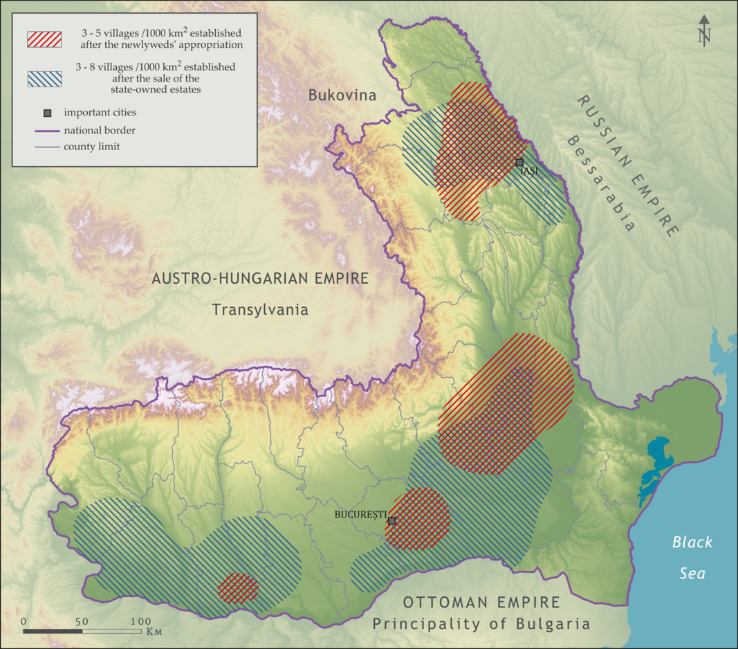
Spatial analysis was also used to identify the areas with densities greater than three villages per 1,000 km2, both for the newlyweds’ villages, as well as for the villages that appeared after the sale of the state-owned domains (Figure 6).Footnote 72 The results showed the existence of four distinct areas where settlements from both categories were established. In Moldavia, the colonisation process was extended, after 1889, south of Iaşi, but more importantly, towards the plateau region. In Wallachia, the majority of newlyweds’ villages were formed in the Counties of Brăila, Râmnicu Sărat and Buzău, but also East of Bucharest. Authorities extended the colonisation towards the Bărăganului Plain and in the south of Ilfov and Vlaşca Counties starting from 1889. In western Wallachia, the settlements that appeared after 1889, were far more numerous than the ones registered between 1878 and 1882. Initially, the highest densities of new villages were recorded in Romanaţi County, but after the sale of the public domains, the settlement network extended to certain parts of Dolj, Mehedinţi, Olt and Teleorman Counties. The analysis of the highest densities of newly established villages sheds new light on the evolution of the landownership regime in nineteenth-century Romania. The areas highlighted on the map largely overlap with the former ecclesiastical domains, suitable for agriculture. Furthermore, the map shows the moment when certain regions of the country started to be populated due to land ownership and agrarian transformations that followed the abolition of the corvée.
The areas with the highest densities of villages established after the newlyweds’ appropriation and the sale of the state-owned estates. Cartography: Theodor Cepraga.
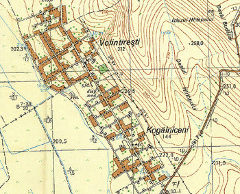
Apart from the 274 newly established settlements, seventy-seven other older settlements had their built up area extended, as a result of the law. Among these, fifty-one villages had been established before the second half of the nineteenth century, while another twenty-six were founded between 1878 and 1882 by the newlyweds. The expansion of the newlyweds’ villages confirms that significant parts of the public estates remained as the property of the state, only to be sold in small plots, after the 1889 law. In some cases, the new villages were formed in the vicinity of a newlyweds’ settlement, as in the case of Volintireşti and Kogălniceni villages (Figure 7). Both of them were established on a domain owned before 1863 by the Neamţ Monastery. In 1878, the village of Kogălniceni was established by newlyweds, and two decades later, north of it, the village of Volintireşti appeared. Until today, from a total of 274 new villages, eighty were integrated into other settlements, and one village became a neighbourhood of the city of Călăraşi. A total number of eleven villages, all from Wallachia, disappeared, following severe floods or because their inhabitants moved to other prosperous, neighbouring villages.
The villages of Volintireşti and Kogălniceni, Roman County, on the Romanian Topographic Map, second edition (1972–81).

The regular plans of the newly established settlements resemble very much the ones designed by the topographic engineers for the newlyweds’ villages. Due to this morphological characteristic, these settlements easily stand out from older villages. The toponymy is another characteristic that was inspired by the foundation of the newlyweds’ villages.Footnote 73 The evocation of the Romanian royal family members is much more present, while the toponyms reminiscent of the Russo-Turkish War of 1877–8 (Romanian Independence War) are no longer frequent. A total number of thirteen settlements were denominated after the members of the royal family. Among these, four villages received the name of the future King Carol II (at that time, Prince Carol), three villages had the name of the future Queen Marie (at that time, Princess Marie) and another two villages bore the name of King Ferdinand, under the name Prince Ferdinand. Other members of the royal family whose names were given to various settlements were King Carol I, Queen Elisabeth, Princess Maria and Prince Nicholas. Many villages were named after Emperor Trajan (five settlements), Prince Alexandru Ioan Cuza (three settlements), the prime ministers Mihail Kogălniceanu and Lascăr Catargiu, writer Ion Heliade-Rădulescu and voivodes Alexandru cel Bun (Alexander I of Moldavia) and Stephen the Great. Three villages were named Dorobanţu (meaning soldier) and two other Independenţa (meaning Independence), thus praising the Romanian Independence War. In Ialomiţa County, a village was given the name of Satul Model, meaning ‘the model village’ to honour the fact that it was a place where the state ensured the building of quality housing for peasants. More than twenty settlements were named Satu Nou (the new village), and many others took the name of an older village to which the word ‘new’ was added: Ciupercenii-Noi, Cârligaţii-Noi, Moviliţa-Nouă, Reviga-Nouă, etc. Numerous other villages borrowed the name of the estate on which they were established.
Peasants’ response and critical opinions of the internal colonisation
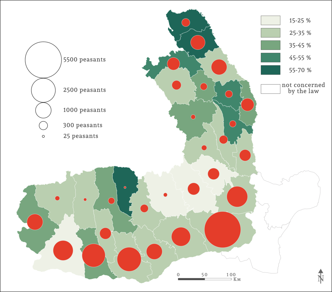
As part of the sale of public domains, the internal colonisation started in 1889 and continued for the next twenty years. In 1909, the statistics compiled by the Ministry of Agriculture and Domains revealed that only 25,571 peasants settled in the newly established villages.Footnote 74 This represents approximately one third of the total number of purchasers who received a household plot. In southern Wallachia, even though the majority of the peasants were able to move into a new village, less than 35 per cent changed their residence (Figure 8).Footnote 75 The largest number of resettled peasants came from Ialomiţa County, but they only represented 31 per cent of the total number of purchasers. The worst results were registered in Râmnicu Sărat, Buzău, Prahova and Dolj Counties, where less than 25 per cent of the peasants changed their domicile. Compared to Wallachia, by 1909 the internal colonisation from Moldavia gave better results. In Dorohoi and Botoşani Counties, between 55 per cent and 70 per cent of the buyers moved to their new homes, while in Suceava, Vaslui and Tutova, this quota was of approximately 50 per cent. At a national level, the worst effects of the colonisation were observed in the Romanian Plain, where authorities believed that it would provide the best results. One explanation could relate to the fact that the majority of those who bought land in this region came from the Carpathians or Subcarpathians, thus from a significant distance, which proved to be a major impediment to change their domicile.
Percentage of occupied household plots and the total number of resettled peasants. Cartography: Theodor Cepraga.

After the purchase of the plot, the peasants could apply for an Agricultural Credit, in order to buy cattle, tools, but also to cover their expenses from the relocation to the new village. Beginning with 1896, lending stopped because it was discovered that the peasants had used the money for other purposes, and therefore, only seventy-five peasants benefited from this type of loan.Footnote 76 In the early years of the twentieth century, the Ministry of Agriculture and Domains ordered the Prefectures to force the people to settle on the purchased plots. The peasants responded that they lacked the means to relocate and build new homes. Other reasons invoked ‘drunkenness, laziness, old age’.Footnote 77 In many cases, only several peasants decided to construct their homes in the newly designed built up area. They had to face shortcomings related to the unequal spreading of houses inside the built up area because other peasants were grazing their cattle on the household plots, thus ruining the tillage areas of those who decided to relocate. Because the peasants who were living on neighbouring estates were not forced to move to the newly acquired property, the number of resettled peasants remained low. Unlike the law of 1886, which imposed dispossession in case of refusal to relocate to the purchased plot, the law of 1889 did not introduce any such sanctions. The old stipulation was never enforced because no village was created following the 1886 law.
In order to stimulate the peasants to change their residence, authorities decided to build houses in two of the newly established villages. Thereby, 205 houses were constructed in Model Village and another 165 houses in Princess Maria village (nowadays, Înfrăţirea). Although the buyers had to move to the new houses, they refused and, in some cases, they only made their appearance at the reception of the dwelling. Under these circumstances, some of the model houses fell into ruin, and between 1901 and 1903 they were repaired by the state. Only in 1907 was dispossession applied to the purchasers who, until that time, had not relocated.Footnote 78
Until now, only a few authors have analysed the results of the internal colonisation. In a volume published in 1907, historian and agrarian sociologist Radu Rosetti considered that the internal colonisation was ‘a complete fiasco’.Footnote 79 His arguments are based on the fact that many plots were sold to people who were not able to work the land or to pay for them. Other buyers were put on the list by the mayors or notaries who intended to lease the land afterwards. Therefore, some peasants who bought land did not move to the newly established villages and did not work the land, which was leased by the local authorities or tenants, at a price equal to the value of the instalments. Radu Rosetti gives the example of the Belceşti estate, from Iaşi County, renowned for the quality of the soil. It was sold in plots of five hectares to peasants from distant communes who never moved in the new village and never farmed the land. In 1906, Druckmann, a Jewish tenant, administrated more than one hundred plots. Nevertheless, the state did not wish to declare the sales invalid in order to collect the instalment payments. That is why, Radu Rosetti,Footnote 80 speaking of the law from 1889, says that ‘instead of being an excellent measure, it had the most deplorable results’.
Another opinion was published in 1909 by Anton Carp, Minister of Agriculture and Domains, in the foreword of the statistics that revealed for the first time the results of the colonisation. Even though the author was praising the actions taken by the state in the attempt to increase living standards of the peasantry, he portrays the results of the sale of small plots and especially of the colonisation in a negative light. Having a similar opinion to Radu Rosetti, his arguments emphasised that the land bought by the peasants was leased to third parties and that only one third of the household plots in the newly established villages had been actually occupied.Footnote 81 His ideas were quoted by the agronomist Gheorghe Ionescu-Şişeşti who also considered that the internal colonisation failed because the peasants did not have the financial means to relocate or because they were not even interested in doing that.Footnote 82
Anton Carp’s assertions were strongly criticised by Vasile M. Kogălniceanu, writer and politician, son of the former prime minister Mihail Kogălniceanu. He considered that the sale of public lands to the peasantry, following the laws from 1881 and 1889, produced ‘admirable results’.Footnote 83 Ironically, Kogălniceanu’s opinion was based on the figures published by the Ministry of Agriculture and Domains, led by Anton Carp. Vasile M. Kogălniceanu highlighted the fact that 85 per cent of the land sold from the public domains was actually farmed by the peasants who bought it and only 13.5 per cent of the plots were leased.Footnote 84 At the same time, no more than 13.9 per cent of the purchasers had a two-year delay in paying the instalments.Footnote 85 Regarding the internal colonisation and the fact that only one third of the peasants had settled in the new villages by 1909, Kogălniceanu noticed that if the peasants had received loans according to the laws, they would have settled the newly established villages in an even greater number. He also pointed out that peasants were travelling long distances to work their plots even though the state was not preoccupied with helping them change their domicile. Finally, Kogălniceanu considered that the foreword published by Anton Carp revealed a negative opinion regarding the colonisation because the minister did not support the sales of land to peasants, but only the leases.Footnote 86
The opinions of Radu Rosetti, Anton Carp and Vasile M. Kogălniceanu were all published before or very shortly after the colonisation ended so its results were not that obvious. After the First World War and the agrarian reform from 1921, the prewar internal colonisation quickly fell into oblivion. The researchers interested in the evolution of the agrarian regime simply republished the relevant figures regarding the sale of public lands without critically analysing the long term effects of the colonisation.Footnote 87
In the short term, the sale of public lands did not improve the living condition of the peasantry, a fact proved by the outbreak of the 1907 Peasants’ Uprising.Footnote 88 In the long run, the 1889–1909 rural colonisation could be considered a success due to the fact that 274 new villages were established, seventy-seven others were enlarged and only eleven villages disappeared as a consequence of natural disasters or depopulation. The only favourable opinion regarding the internal colonisation, asserted by Vasile M. Kogălniceanu, took into consideration the slow place at which the new villages were growing, largely due to poverty.
Another fact that confirms that the establishment of new settlements was a success, in the long run, comes from the data extracted from three different censuses.Footnote 89 The villages situated in areas with the highest density of new settlements recorded high rates of population growth. In Moldavia, in Iaşi County, the population from the new villages grew, on average, by 34 per cent between 1912 and 1930 and by 22 per cent between 1930 and 1941. In Ialomiţa County, the population of the new villages grew by 28 per cent and 22 per cent, respectively.Footnote 90 Some settlements even recorded a growth of population higher than 60 per cent between 1912 and 1930, figures that can only be explained by migration due to internal colonisation. Therefore, the newly established villages have indeed consolidated, but over a long time, and the critical opinions of the internal colonisation were published too soon after the process had officially ended.
Conclusion
The agrarian transformations from the second half of the nineteenth century and the subsequent evolution of the peasantry in the Romanian Kingdom have been the subject of research for several studies, but the sale of the state-owned estates fell somewhat into oblivion. The internal colonisation, which took place at the end of the nineteenth century, was critically analysed by a few authors and its results in the long term have never been fully understood. The current article examines from a geographical perspective the sale of public estates and the internal colonisation that soon followed. It focuses on the creation of new settlements in low populated, but fertile areas. Particular attention was paid to peasants’ response to colonisation and the critical opinions published at that time by both politicians and rural sociologists.
The first part of the research focuses on the legislation passed in 1881 and 1889 and the conditions stipulated by these laws concerning the sale of the state-owned estates. With the help of the statistics published by the Ministry of Agriculture and Domains, the authors were able to analyse the results of the sales from a spatial perspective. Most plots were sold in southern Wallachia, a region renowned for its fertile lands. In Moldavia, the majority of sales took place in counties where an important part of the peasantry was free of corvée before 1864, thus having the financial means to buy land. The sales of land were less important in counties from the mountainous regions where the quality of soil was low.
The data extracted from the official statistics published by the Ministry of Agriculture and Domains were corroborated by other sources and used to map the newly founded settlements as a result of internal colonisation. The spatial analysis conducted using GIS revealed the areas with the highest densities of new villages. A comparison with the analysis showing the density of the newlyweds’ settlements showed that the process of creating new villages was particularly concentrated in four distinct nuclei. These were located in the plain region of northern Moldavia, northern Bărăganului Plain, East of Bucharest and the southern Romanaţi County. The reasons for the creation of new villages in these areas were linked to the presence of excellent conditions for agriculture and the existence of scarcely populated monastic domains, before their secularisation.
This article also investigates how the peasants reacted to internal colonisation in terms of relocation to the newly established villages. Until 1909, only one third of buyers moved to their new household plots, largely due to their lack of financial resources. Although the laws mentioned the possibility for peasants to contract loans, only seventy-five families benefited from the Agricultural Credit. Another fact that contributed to the low occupation of the household plots was an article of the law, which exempted from this obligation the buyers who lived close to the purchased land and did not inflict any sanctions on the others.
Just before the colonisation came to an end, or very soon after, several authors attempted to analyse its results. Sociologist Radu Rosetti and the politician Anton Carp published negative accounts concerning this process. They argued that the peasantry leased its lands and that they were not interested in relocating to the new villages. On the other hand, Vasile M. Kogălniceanu stated that the colonisation was a success considering the financial difficulties the peasantry had to face in the context of relocation and the lack of support shown by the state. The figures extracted from the population censuses from the interwar period that indicate high rates of population growth in the new villages, in the decades following the colonisation, support Kogălniceanu’s opinion.
Acknowledgements
The authors would like to thank Dr Alina Mareci for constructive comments and suggestions.