Introduction
As humanity's footprint on Antarctica's ice-free areas increases, so does the competition with native flora and fauna for habitat. Ice-free areas constitute < 1% of the continent's area, but these same areas are favoured for the siting of permanent stations and summer bases, research, tourism and other activities (Brooks et al. Reference Brooks, Jabour, Van den Hoff and Bergstrom2019). If we understand better the spatial distribution and environmental determinants of the flora and fauna of these ice-free areas, we will be better able to minimize human impacts on them. Despite several dozen research trips to Bunger Hills (Fig. 1) since the establishment of permanent buildings (Dobrowolski/Oasis-2 Station, Edgeworth David Base) in the 1950s to the 1980s (Gore et al. Reference Gore, Gibson and Leishman2020, their table I), only opportunistic records and studies of the flora and fauna have been published. Seventeen lichen species were recorded in the 1970s (Barker Reference Barker1977), with further detail including descriptions of species distributions in Olech (Reference Olech1989), Bolshiyanov et al. (Reference Bolshiyanov, Verkulich, Pushina and Kirienco1991) and Olech & Alstrup (Reference Olech and Alstrup1996), leading to a list of 41 lichen species reported for Bunger Hills (Andreev Reference Andreev1991).
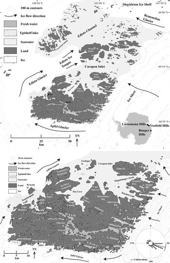
Location of Bunger Hills, showing regional setting (upper panel), studied area (lower panel) and places mentioned in the text. In the lower panel, the three research stations are marked as O = Oasis-2, D = Dobrowolski, ED = Edgeworth David Base. AWS = the former locations of two automatic weather stations, and the wind rose in the lower right shows the dominant wind direction at the Edgeworth David AWS during the 1985–86 summer. Each dot on the wind rose represents three observations of a 3 h measurement.

Two systematic investigations of the biology of Bunger Hills (Leishman & Gore in 1995–96, Gibson in 2000) found that terrestrial flora was limited to algae, fungi, mosses and lichens, and terrestrial fauna was limited to birds and invertebrates, with occasional visits by seals. Lichens were more abundant near meltwater and surface streams in the south of the area close to the Apfel Glacier margin, and they were rarer in the areas in the north and west, possibly because of increased soil salinity created by aerosols from marine inlets and salt lakes (Gibson Reference Gibson2000, Gore & Leishman Reference Gore and Leishman2020a, Reference Gore and Leishman2020b). However, because not all of the land area of southern Bunger Hills, and particularly the areas upwind of the marine inlets, was surveyed, it was not clear whether or not salinity was the dominant control on the distribution of lichens across Bunger Hills.
Four species of birds have been recorded from Bunger Hills. Snow petrels (Pagodroma nivea) are the most abundant, with their nests occurring in rock crevices and overhangs in the north, centre and south of the hills, and particularly along the Apfel Glacier margin (Bulavintsev et al. Reference Bulavintsev, Golovkin and Denisova1993, Verkulich & Hiller Reference Verkulich and Hiller1994, Gibson Reference Gibson2000). Their population has been estimated at up to 1000 individual birds (Bulavintsev et al. Reference Bulavintsev, Golovkin and Denisova1993). Wilson's storm petrels (Oceanites oceanicus) are rare and dispersed (Gibson Reference Gibson2000), with their cryptic nests typically constructed in sandy and gravelly sediment (Filcek & Zielinski Reference Filcek and Zielinski1990). South polar skuas (Catharacta maccormicki) are more commonly seen flying and at feeding or washing sites than at the rough nests they construct amongst the gravels on the ground surface. Up to 50 individuals have been estimated at Bunger Hills (Gibson Reference Gibson2000). Rarely, Adélie penguins (Pygoscelis adeliae) are found in Bunger Hills (Filcek & Zielinski Reference Filcek and Zielinski1990, Gibson Reference Gibson2000); however, there are no breeding colonies, as access is limited by Shackleton Ice Shelf.
The biogeography of Bunger Hills and reasons for the spatial distributions of the species are poorly known. The first aim of this paper is to assess all of southern Bunger Hills by combining Gibson's (Reference Gibson2000) data with unpublished observations collected by Leishman and Gore. A clear understanding of the biogeography of the region is confounded by uncertainty in the identification of species due to changes in taxonomy, nomenclature and difficulties of specimen identification. In order to avoid this problem, we have only mapped the distributions of flighted birds and the more abundant terrestrial plants, where their identifications are unambiguous. Probable environmental controls, particularly sediment salinity and available water, were investigated as controls on the distribution of plants in southern Bunger Hills.
Methods
During the December 1995/February 1996 field season, the presence/absence of terrestrial plants was recorded via foot traverses on a 1 × 1 km grid across southern Bunger Hills (Fig. 1). In total, 242 1 km2 grid cells were investigated. Some 1 km2 grid cells were traversed repeatedly, while others, particularly the more remote eastern and south-eastern areas, were traversed only once. Lichens were identified in the field, with nomenclature consistent with Filson (Reference Filson1966) and Seppelt (Reference Seppelt1984). For the analysis of spatial distribution, we report five relatively abundant, taxonomically robust lichen species. Due to taxonomic uncertainties, mosses were not recorded in the field at species level, but were recorded in terms of presence/absence only. The presence of birds was recorded where they were seen (grid references; all three species) or at nesting sites (grid references; snow petrels only). A 100–200 g scrape of the surface 2 cm of sediment (n = 252 locations) was collected within 200 m (and in most cases within 100 m) of each 1 km grid intersection (Fig. 1). Extracts made from these surface sediments were analysed for conductivity. Samples were extracted by slow rolling 10 g of sediment and 50 ml of deionized water in glass tubes for 2.5 h, and then centrifuging at 3000 rpm for 10 min. Conductivity was determined using a Radiometer CDM80 conductivity meter, and due to the large range in values, the data are displayed using a square root transformation to highlight spatial differences.
During the December 1999/January 2000 field season, 175 1 km2 grid cells were visited on foot and the presence of lichens, mosses and birds recorded. These new data were collated with published records (Barker Reference Barker1977, Olech Reference Olech1989, Andreev Reference Andreev1991, Olech & Alstrup Reference Olech and Alstrup1996) and summarized in Gibson (Reference Gibson2000), although as we are uncertain of the exact locations of these earlier observations, we have not collated them into this report.
For each of the lichen species and the combined moss species, we tested for a relationship between presence/absence and sediment conductivity using the combined dataset for all time periods from 1995–96 and 1999–2000 (two-sample t-test, Minitab Express, v. 1.5.1).
Results
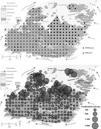
The 1995–96 field season was the most extensive of the expeditions in its areal coverage, and the 1999–2000 season overlapped the 1995–96 research areas (Fig. 2a). Only a few ice-marginal areas were not visited in either season; these were largely in the south-east where snowdrifts make access difficult.
Upper panel: Bunger Hills, showing regions surveyed during the 1995–96 (n = 242 locations) and 1999–2000 (n = 175 locations) field seasons. Lower panel: sediment conductivity (square root transformed; n = 252 locations from the 1995–96 season).

Water extracts from sediments showed high conductivities in the coastal fringes and in northern areas of the hills, particularly to the north of an east–west line defined by the southernmost extent of Paz Cove, Ostrovnaya Bay and other marine bays (Fig. 2b). The eastern shore of Transkriptsii Gulf also had salinities higher than many areas to the east. Sediment conductivities were lowest close to the ice sheet and glacier.
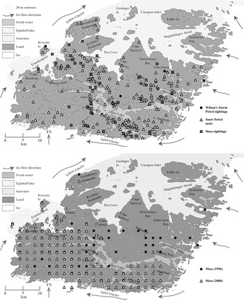
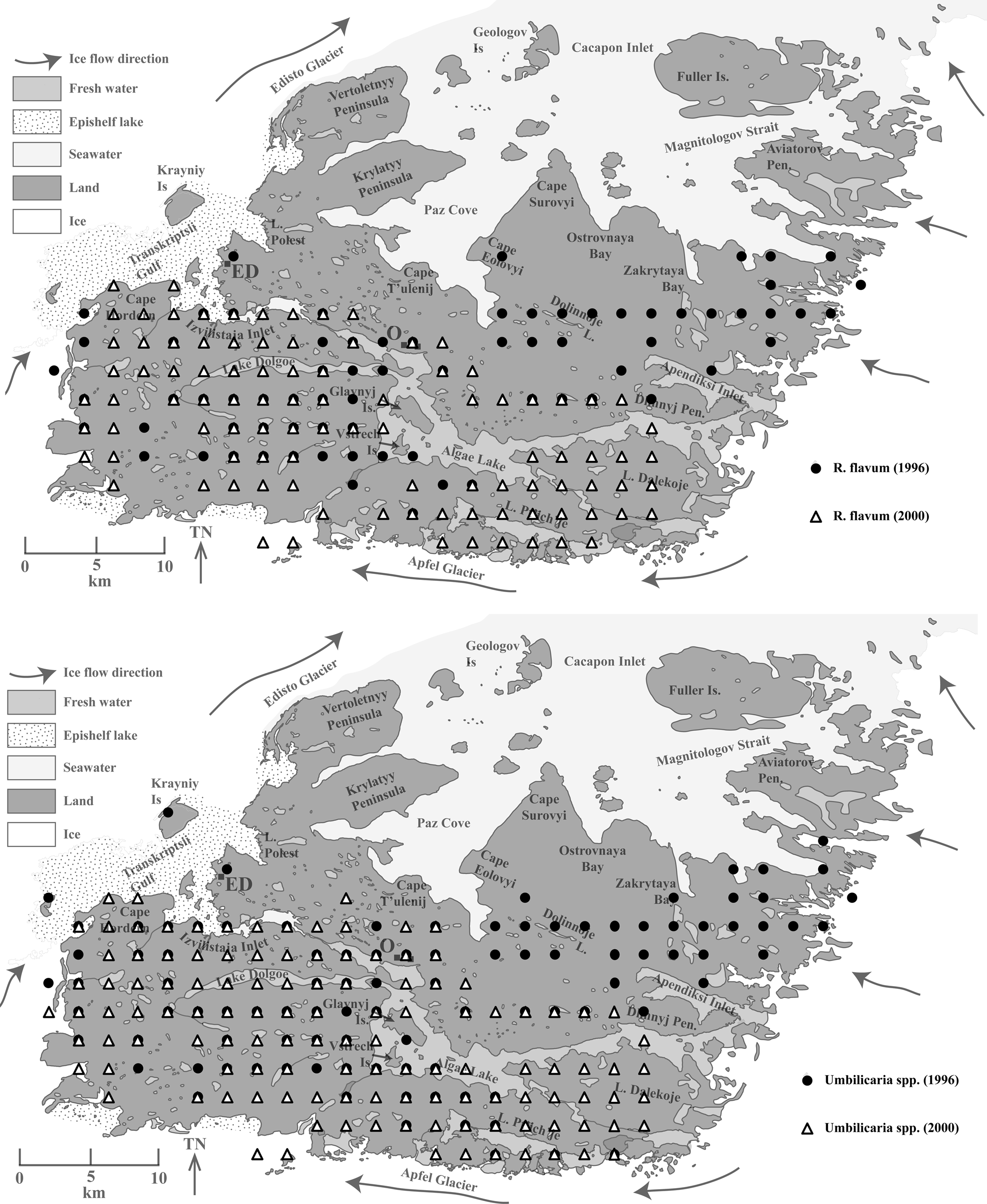
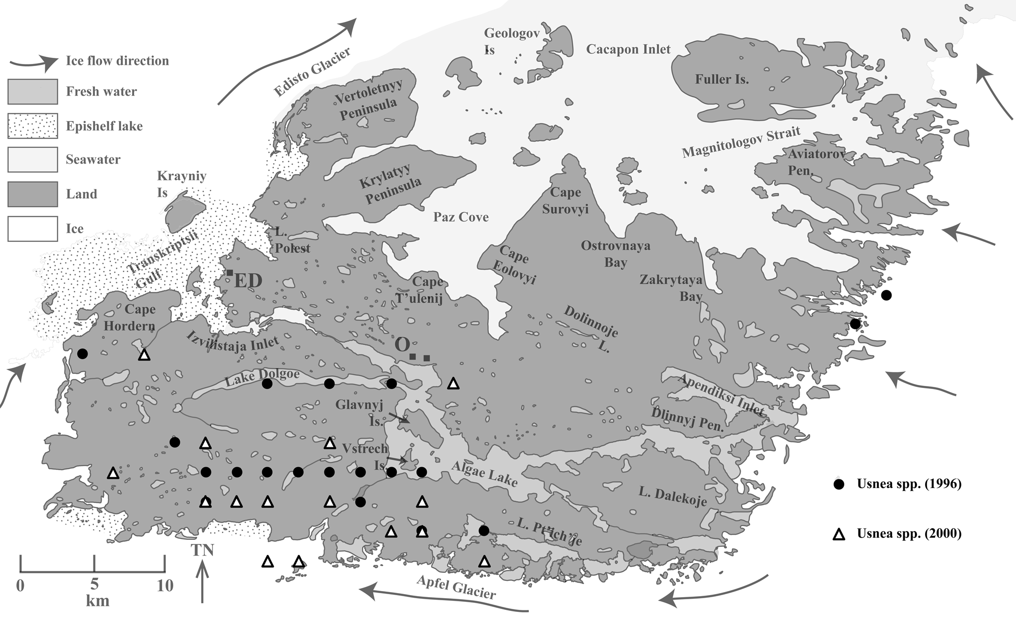
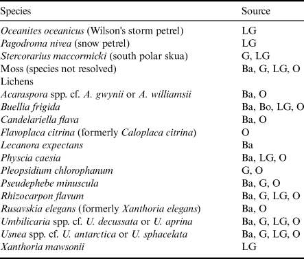
Locations of the three flying bird species (Fig. 3a), mosses as presence/absence in grid kilometres (Fig. 3b) and lichens resolved to species level where possible (Figs 4–6) are shown in grid kilometres. The spatial distributions of abundant species are mapped in order to elucidate biogeographic trends; for the less abundant species, readers are referred to the primary sources (Table I). Here, we map observations of Wilson's storm petrel (O. oceanicus) and south polar skua (S. maccormicki), map nests and observations of snow petrel (P. nivea) and the presence/absence of mosses (all species combined) and the five abundant and readily identifiable lichens Buellia frigida, Physcia caesia, Rhizocarpon flavum, Umbilicaria spp. cf. Umbilicaria decussata or Umbilicaria aprina and Usnea spp. cf. Usnea antarctica or Usnea sphacelata.
Upper panel: sightings of the three flighted bird species at Bunger Hills. Locations were reported as grid references rather than grid km in order to elucidate spatial patterns. Lower panel: spatial distribution of mosses (all species).

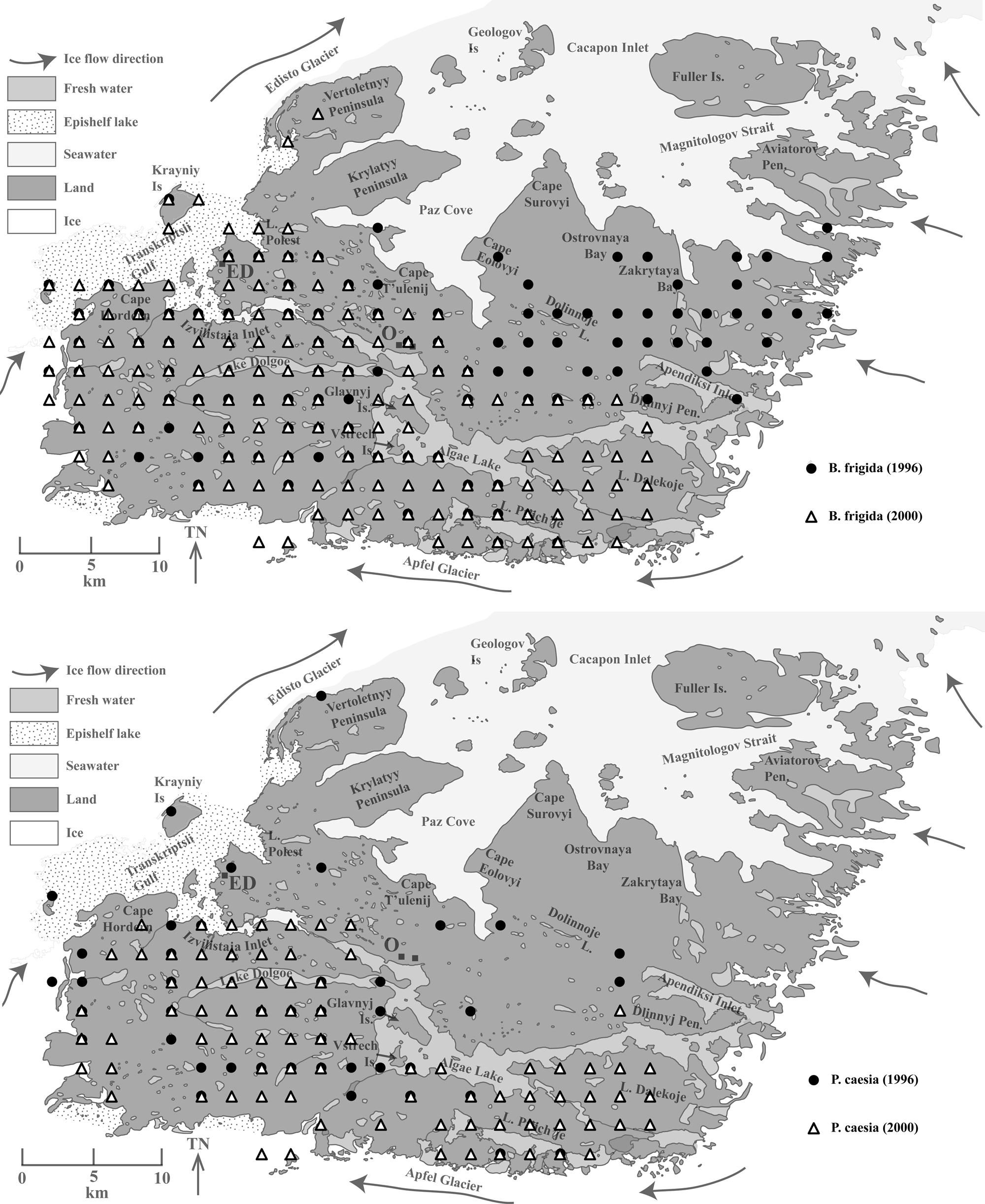
Upper panel: spatial distribution of Buellia frigida. Lower panel: spatial distribution of Physcia caesia.

Upper panel: spatial distribution of Rhizocarpon flavum. Lower panel: spatial distribution of Umbilicaria spp.

Spatial distribution of Usnea spp.

Sources of information for the birds and plants of Bunger Hills.

Sources: Ba = Barker (Reference Barker1977), G = Gibson (Reference Gibson2000), LG = Leishman & Gore (1995–96 season, this paper), O = Olech (Reference Olech1989) and Olech & Alstrup (Reference Olech and Alstrup1996). Further details are in Gibson (Reference Gibson2000, his appendix 6).
Birds
Wilson's storm petrels are cryptic. They are small, quiet, dark coloured, fly close to the ground and difficult to observe. We observed burrows as nests in the sediment. However, as nesting birds could not be observed directly and nest occupancy was unknown, and as burrows are similar to cavities created by melting ground ice, we only recorded sightings of Wilson's storm petrels. The sightings we have of their in-flight movements did not exhibit obvious spatial distributions. In contrast, snow petrels are bright white, often fly high above the terrain and with distinctive swooping or evasive manoeuvring so they are easily observed over relatively large distances. They can also form large groups and communicate noisily so that their nests are located easily. Snow petrel nests are found in rock crevices and overhangs, which form particularly in areas of strongly jointed rock. The dominant south-east–north-west band of snow petrel nest distribution (Fig. 3a) is along a large mafic dyke (Verkulich & Hiller Reference Verkulich and Hiller1994, Tucker et al. Reference Tucker, Hand and Clark2020, their fig. 2), which is strongly jointed in places and forms abundant potential for nesting sites. Snow petrel nests are also found anywhere else in southern Bunger Hills where crevices are present in cliffs. Although we saw skua nests, we have not reported their positions. Skuas are highly visible animals, as they are relatively large, fly high above the terrain, congregate in small groups and are noisy. They were mainly observed in flight around snow petrels, which is the skua's main food source in Bunger Hills, or on roosts on hilltops or the tops of boulders. They were also observed washing and preening in small freshwater streams and ponds after feeding and around places of human activity, including the station buildings at Edgeworth David, Oasis-2 and Dobrowolski (Fig. 1).
Mosses and lichens
Mosses were present in southern Bunger Hills generally south and west of Algae Lake. Mosses were also common in the area west of the freshwater Apendiksi Inlet (Fig. 3b), although they were locally abundant elsewhere, such as the northern margin of Vertoletnyy Peninsula, where the land abuts, and in places receives melt from, glacier ice. Mosses were generally absent from the 3 km-wide undulating plain of bouldery glacial sediment, which lies a few kilometres south-east of the southern tip of Paz Cove. Sediment conductivity was significantly lower (mean = 136 μS cm-1) where moss was present compared to where it was absent (mean = 761 μS cm-1) (P = 0.003, df = 147). The most widespread, and probably the most abundant lichen was B. frigida (Fig. 4a). Buellia frigida was present across the southern hills, throughout all of the area south and west of Algae Lake, but also extending northwards into the salty zone to the shore of Paz Cove and Cacapon Inlet. In contrast, Vertoletnyy and Krylatyy peninsulas and the salty area around Cape Surovyi and Ostrovnaya Bay had almost no B. frigida (Fig. 4a). Sediment conductivity was significantly lower (mean = 148 μS cm-1) where B. frigida was present in comparison to where it was absent (mean = 1071 μS cm-1) (P = 0.002, df = 96). The lichen P. caesia was restricted almost completely to the south and west of Algae Lake (Fig. 4b). Sediment conductivity was significantly lower (mean = 70 μS cm-1) where P. caesia was present than where it was absent (mean = 692 μS cm-1) (P < 0.001, df = 176).
The spatial distributions of the lichens R. flavum (Fig. 5a) and U. decussata (Fig. 5b) are similar: they were recorded to the south and west of Algae Lake and northwards to an east–west line defined by the southern tip of Paz Cove. An exception for both species was an absence from the 3 km-wide area defined by the undulating plain of bouldery glacial debris, from where the mosses and lichen B. frigida were also absent. Sediment conductivity was significantly lower (mean = 89 μS cm-1) where R. flavum was present compared to where it was absent (mean = 870 μS cm-1) (P < 0.001, df = 131). Similarly, sediment conductivity was significantly lower (mean = 122 μS cm-1) where U. decussata was present than where it was absent (mean = 919 μS cm-1) (P = 0.001, df = 119).
The distribution of the lichen Usnea spp. cf. U. antarctica is the most restricted of the lichens considered here (Fig. 6), occurring only in locations south and west of Algae Lake or, rarely, in rock outcrops at the ice sheet margin, south of Lake Shchel. Sediment conductivity was significantly lower (mean = 94 μS cm-1) where U. antarctica was present in comparison to where it was absent (mean = 532 μS cm-1) (P = 0.001, df = 247).
Discussion
Regional gradients and local controls
The wind rose for Bunger Hills (Fig. 1) (Gore & Leishman Reference Gore and Leishman2020b) shows that winds prevail from the east–south-east, but that some winds also blow from the west–north-west. Gore & Leishman (Reference Gore and Leishman2020b) discussed how strong winds blow from the east–south-east, whereas those blowing from the west–north-west are gentler. This is important for the distribution of marine-derived salt spray downwind from marine inlets during the summer months, the types of salts and their distribution (Gore & Leishman Reference Gore and Leishman2020a). Strong wind directions are probably also important for the dispersal of plant spores and for snow accumulation in crevices and burrows that might be used for nesting. The pattern of sediment conductivity across southern Bunger Hills shows that sediments exhibit greater conductivities downwind of marine Zakrytaya Bay, Ostrovnaya Bay, Paz Cove and Izvilistaya Inlet (Fig. 2b). Single points of enhanced conductivity around the hills result from sampling in local evaporation basins where salts have been washed and have accumulated over time. The regional pattern of a gradient from salty to the north and west downwind of the coast and fresher to the south and east closer to the ice sheet and glacier has bearing on the ability of plants to grow in those locations. As a result, the presence or absence of moss and the five species of lichens mapped here is significantly related to sediment salinity. Although the distribution of all five lichen species examined was significantly associated with sediment conductivity, such that all five species were more commonly observed in the less salty areas of Bunger Hills, there were nevertheless some differences among the species. Usnea spp. had the smallest distribution, being largely confined to the south-west of southern Bunger Hills. Rhizocarpon flavum, P. caesia and Umbilicaria spp. had similar distributions, being largely confined to the southern, less salty areas. Buellia frigida was the most widespread of the lichen species, extending into the southern edge of the salty zone to the shore of Paz Cove and Cacapon Inlet, suggesting that it may be the most salt-tolerant of the five lichen species assessed.
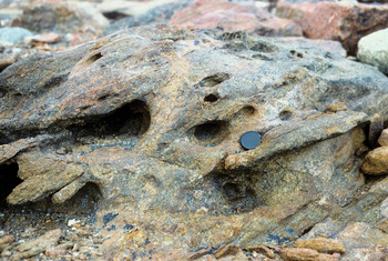
Salt can control plant growth in at least two ways. First, salt imposes osmotic stresses that limit plant growth. Second, enhanced weathering of rock surfaces has also been described from those salty areas (Gore & Leishman Reference Gore and Leishman2020a), similarly to other salty areas in Antarctica (Adamson & Pickard Reference Adamson, Pickard and Pickard1986, Pickard Reference Pickard and Pickard1986, Gore et al. Reference Gore, Creagh, Burgess, Colhoun, Spate and Baird1996, Kiernan et al. Reference Kiernan, Gore, Fink, McConnell, Sigurdsson and White2009), and in these areas, abrasion by wind-driven mineral sand grains and ice particles reduces the ability of plants to establish and thrive. In these areas, micro-habitats such as tafoni (Fig. 7) offer protection from wind-driven particles. The virtual absence of mosses (Fig. 3b) and lichens (Figs 4–6) from the open, undulating till plain 2–3 km to the south-east of the southern tip of Paz Cove probably results as much from a lack of protection from blown sand and ice particles as it does from the lack of water during the mid-late summer after the loss of winter snow patches.
Small lichens in tafoni, where microhabitats provide increased moisture and shelter from abrasion. Lens cap is 50 mm in diameter.

Consistent trends were observed in the distribution of lichens and mosses in stream beds and around lakes at southern Bunger Hills. Along streams, lichens dominated the vegetation away from the thalweg and in micro-topographic high points (Fig. 8) in areas that would receive water from spray but were not submerged (Gibson Reference Gibson2000; his fig. 43a). Closer to the centre of the stream, mosses were prevalent, but in the centre of the stream, where flow would be consistently strongest, both mosses and lichens were absent, and black cyanobacterial crusts were the only apparent vegetation. This distribution reflects the habitat requirements of the various vegetation types. Lichens require less water than mosses (Leishman & Wild Reference Leishman and Wild2001) and may be more prone to damage by strong flow, so they concentrate at the stream margins. Mosses require greater water availability, but are less able to withstand deep water flows. Cyanobacterial crusts can survive in areas of low water abundance (e.g. in an outer ring around lakes), and there is no need for them to be in the area of greatest water flow in the middle of the stream. It is probable that these crusts are better able to withstand erosion in the place of deepest water flow.
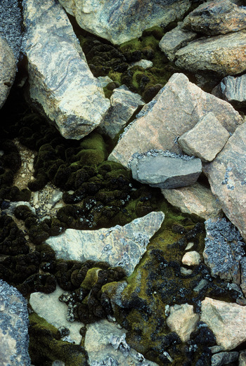
Moss in moist crevices between boulders, with lichens occupying slightly drier microhabitats. Field of view is 0.5 m across.

Birds
The distribution of snow petrels is habitat-driven. Because they are predated upon aggressively by skuas (cf. Swärd Reference Swärd2014), any petrel remaining in the open is likely to be killed readily. Snow petrel nests occupied crevices and overhangs in bedrock, which offer protection from predation by skuas. The requirements of the crevice or overhang are that it must be deep enough for the birds to hide effectively, it must be constricted enough for the snow petrel to defend itself and the nest from the larger skua and it must not be prone to the accumulation of wind-blown snow that might prevent egress. North-facing cliffs did not seem to be favoured, as they were at Dronning Maud Land, at Svarthammaren (71°54’S, 05°10’E) (Haftorn et al. Reference Haftorn, Mehlum and Bech1988), and no directional bias in nest sites was observed at Bunger Hills. These requirements are most commonly met in the jointed mafic dyke that lies across Bunger Hills, but the orthogneisses (Tucker et al. Reference Tucker, Hand and Clark2020) also provide suitable nesting locations. It is probable that the birds prefer nesting locations with enough height above the valley floor to permit taking flight more readily or to shelter more readily from skuas, although additional research is required to elucidate this further.
Mosses
Mosses are widely distributed throughout southern Bunger Hills. Early studies documented the occurrence of Sarconeurum glaciale, Grimmia plagiopodia, Pohlia nutans and Bryum algens in Bunger Hills in a wider, East Antarctic context (Savich-Lyubitskaya & Smirnova Reference Savich-Lyubitskaya and Smirnova1966, Reference Savich-Lyubitskaya and Smirnova1971a, Reference Savich-Lyubitskaya and Smirnova1971b, Reference Savich-Lyubitskaya and Smirnova1972), and provided a description of Bryum korotkevicziae in samples dredged from a depth of 36–39 m in Algae Lake (Savich-Lyubitskaya & Smirnova Reference Savich-Lyubitskaya and Smirnova1964). This aquatic species, characterized by long stems and sparsely distributed leaflets, is an aquatic growth form of Bryum pseudotriquetrum and should not be considered a separate taxon (Seppelt Reference Seppelt1983, Reference Seppelt and Pickard1986a). Kuc (Reference Kuc1969) recorded four moss species in samples collected in 1959, including some rarely reported elsewhere in Antarctica. Amongst these was the description of a new form: Grimmia doniana cf. antarctica. Barker (Reference Barker1977) listed three species of moss from samples collected during 1977 fieldwork, as well as a further, unidentified species. Olech (Reference Olech1989) provided limited records for two species. Finally, unidentified mosses were also recorded from Geographers (Currituck) Island (Melles Reference Melles1994) in northern Bunger Hills, and were noted in sediment cores taken from lakes, where they are an important indicator of lacustrine, rather than marine conditions (Bolshiyanov et al. Reference Bolshiyanov, Verkulich, Pushina and Kirienco1991, Verkulich & Melles Reference Verkulich and Melles1992).
During the 1995–96 and 1999–2000 fieldwork, moss was found widely throughout southern Bunger Hills (Fig. 3b). No attempt was made to resolve them to species level. The distribution of mosses appeared to be limited by the presence of salt in the region to the north and east of Edgeworth David Base (Vertoletnyy and Krylatyy peninsulas), as well as to the north of Algae Lake near Oasis-2/Dobrowolski Station. Lack of meltwater in much of this region could also restrict moss growth, as less wind-blown snow accumulated there. In general, mosses were common and appeared in better condition in the south of the study area; the moss towards the north was often moribund, heavily lichenized (often by a yellow lichen) or had a cyanobacterial crust covering it. The most lush mosses were found in melt streams emanating from snowbanks or in streams between lakes. Of particular importance were drainage systems that included periglacial cracks in sediment, which can provide microhabitats including water and protection from wind and driving snow and ice. Such cracks were widespread in sediment in the south of the area studied, but became rarer to the north (Gore & Leishman Reference Gore and Leishman2020a). Moss beds up to ~1 m2 in area were observed in areas, but in no places were larger moss bed areas such as those prominent in Windmill Islands (Melick et al. Reference Melick, Hovenden and Seppelt1994) present. Along larger streams, mosses were restricted to the margins where shallow water flow prevails. Mosses were also present in moraines along the margins of the ice-free land, noticeably in areas where lichens were sparse or absent. Mosses were never abundant in locations where periods of desiccation occur. For example, small snowbanks are typically transient sources of water and may ablate away each year, leaving mosses to desiccate each summer. In contrast, mosses downhill of glacier ice or larger snowbanks might be supplied with meltwater during the complete summer period each year, allowing mosses to thrive in moist conditions all summer.
Lichens
A report of lichen studies in Bunger Hills (Andreev Reference Andreev1991) lists 41 species from 22 genera and 9 families. Our subsequent studies found lichens to be common over much of southern Bunger Hills, south and west of Algae Lake. Except for areas to the north and east of Edgeworth David Base, nearly all 1 km2 grid cells searched by Leishman and Gore in 1995–96 and Gibson in 1999–2000 had at least some lichens. The absence of lichens to the north was probably related to increased soil salinity or exposure to saline aerosols from the marine waters of Paz Cove or the saline lakes of the area, much in the same way that the distribution of lichens in Vestfold Hills is strongly influenced by salt (Adamson & Pickard Reference Adamson, Pickard and Pickard1986, Pickard Reference Pickard and Pickard1986, Gore et al. Reference Gore, Creagh, Burgess, Colhoun, Spate and Baird1996). Available water could also be important, as there is less snow build-up in the northern part of southern Bunger Hills compared with areas closer to Apfel Glacier to the south, and therefore less available melt.
In the north, lichens were limited to scattered colonies of B. frigida typically growing on the sides of boulders and often with a westerly aspect, protected from sand and ice crystals driven by the prevailing strong easterly winds. South of a line passing through Edgeworth David Base and a few hundred metres to the north of Izvilistaja Inlet and Algae Lake, abundance and diversity increased. To the north, communities containing species other than B. frigida occurred in melt streams emanating from snowbanks, but further south they became more widespread. The richest sites were generally found in low-flow stream beds, especially associated with periglacially formed cracks in sediment and on south facing slopes in southern Bunger Hills near Apfel Glacier, where lichen coverage in some areas reached 25–50%. Lichens were also widespread on isolated nunataks to the south of Bunger Hills. Some places along Apfel Glacier margin were lichen-free for some hundreds of metres, indicating very recent retreat of glacier ice or reduction of perennial snowbanks.
Lichen species richness increased from north to south, towards the ice sheet and glacier and away from the marine influence. Around Edgeworth David Base, only one species (B. frigida) was common, whereas to the south of the line mentioned above the number of species increased, with ~20 species found in patches within a band ~1–2 km wide at the southern margin of the Hills.
The crustose species B. frigida was readily recognized, especially in many areas where it is one of the few species present. It was characterized by an effigurate lobed margin, grey to blackish-grey colour, with a lighter zone a few millimetres in from the edge of the thallus. Inside this zone, the colour was again darker. In older colonies, the centre of the thallus had often been lost by abrasion due to blown mineral sand or ice crystals. This species was the most widespread of those surveyed in this study (Fig. 4a) and it is present in nearly every 1 km2 grid cell in which lichens were found. Bunger Hills is similar to Vestfold Hills, where B. frigida is the most widely occurring species (Seppelt Reference Seppelt and Pickard1986b). In general, B. frigida was found on the sides of medium to large boulders, probably due to exposure of the boulder tops to abrasion by ice and sand particles (Fig. 9).
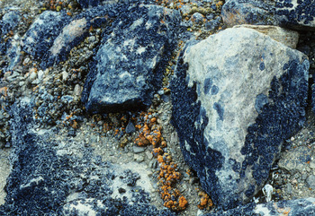
Abundant lichens occur on boulder sides where they are protected by snowlie. Boulder tops exposed to abrasion by wind-driven sand and ice crystals are almost free of lichen. Field of view is 1 m across.

The grey foliose species P. caesia (syn. Parmelia coreyi) occurred over most of southern Bunger Hills (Fig. 4b), where it was most abundant in melt streams and periglacial sediment cracks, commonly in association with other lichen species. The gap in the distribution in the south-west of Bunger Hills probably reflects a lack of late summer moisture from perennial ice or snowbanks.
Rhizocarpon flavum (Fig. 5a) is an easily identifiable crustose species with a yellow areolate thallus with black margins and black between the areoles. In Bunger Hills, it is relatively cryptic, as it often occurs in small colonies in small cracks in rocks. Rhizocarpon flavum was widely distributed throughout the southern portion of the study area, indicating that while it is sensitive to salinity, which precludes it from occurring in the north of the field area, it is relatively robust to desiccation.
The foliose genus Umbilicaria spp. is probably represented by at least two species in Bunger Hills: U. aprina and U. decussata. These species are relatively easily separated in the field, but are mapped together (Fig. 5b). Umbilicaria aprina (with the under-surface of the thalli having hair-like structures or rhizines) was the second most widespread lichen species found in Bunger Hills. It occurred widely in melt streams under snowbanks, as well as very abundantly in periglacial cracks in sediment. In many areas, the cracks on all sides of a sediment polygon in areas of patterned ground were heavily colonized by this species, while the centre of the polygon was lichen-free. Individual thalli were in most cases relatively small (< 2 cm diameter), but occasionally, especially in well-watered areas, they reached 10 cm or more. Umbilicaria decussata (which lacks under-surface rhizines) was observed most commonly in areas close to the rock–ice boundary on the southern margin of Bunger Hills. A possible third species, with relatively small, dark (nearly black) thalli with hairs on the under-surface, was also present in this region. In some areas close to the ice–rock margin Umbilicaria was very common, reaching up to 25–50% coverage of slabs on steep, southern-facing rock hillsides above, for example, lakes Pt'ich'je and Pol'anskogo (Fig. 1).
The fruticose Usnea spp., probably including U. antarctica and U. sphacelata, were sparsely distributed along the south-western margin of Bunger Hills (Fig. 6). Colonies were often well hidden in protected spots, and most consisted of numerous, closely packed thalli. In general, Usnea did not colonize the beds of melt streams, but occurred on rock slabs in areas that receive summer meltwater from local snowbanks. Usnea was also abundant on small nunataks to the south of Bunger Hills. The rarity of this lichen to the north indicates that it is sensitive to salinity, but its rarity to the south-east suggests that desiccation may not be a strong control on its distribution, and other edaphic factors may also control its distribution.
The distribution of lichens suggests that while some species tolerate a wide range of environmental conditions (e.g. Umbilicaria spp. and especially B. frigida), others are restricted to much more limited conditions (Usnea spp.). The occurrence of these more ‘sensitive’ species close to the southern Bunger Hills–Apfel Glacier boundary, as well as the apparent maxima in plant diversity in this region, suggests that the most preferable weather conditions, water and nutrient availability and substrate for lichen growth occur in this area. Two environments are particularly important for lichen growth: melt streams, which were often associated with microhabitats afforded by periglacial sediment cracks, and south-facing rock slopes close to Apfel Glacier. The first were often very heavily colonized by a selection of species, although the intensity of the colonization generally decreased towards the north. Most of the cracks held liquid water when visited, even if they were not part of an active stream. North of Algae Lake, little periglacial activity was apparent and, apart from B. frigida, lichens were restricted to melt streams emanating from larger snowbanks. South-facing rock slopes close to Apfel Glacier were typically quite steep, consisting of large, frost-fractured rocks. Both exposed surfaces and protected interstices harboured abundant lichens and a wide species richness.
Conclusions
The distribution of snow petrels is controlled by the habitat they require for nesting and protection from the predatory skuas. Mosses and lichens are not uniformly distributed across Bunger Hills, but their presence is largely determined by environmental controls, particularly salinity and availability of habitat and water. Plant distributions are controlled primarily by soil salinity, with the areas of greatest salinity (areas within a few kilometres west of Cacapon Inlet, and particularly Paz Cove) having moss and lichen assemblages that are stressed, species-poor and with low abundance. Vertoletnyy and Krylatyy peninsulas, in the north-west of the study area, have high salinity and are almost vegetation-free. Moisture is also a very strong control on species distribution, with some species only thriving where perennial water flows, downstream of glacier ice and perennial snowbanks, are available. The absence of some species in the south-east, which is neither saline nor particularly prone to desiccation, indicates other edaphic factors are also at play. At the outcrop scale, aspect-which affords protection from wind-blown mineral sand or ice crystals-is important.
Acknowledgements
We thank the Australian Antarctic Division for logistic support under AAP 926, Damian Flynn, Belinda Harding, Don Hudspeth and Garry Kuehn for help in the field, Mike Ashelford for drafting the figures and reviewers for improving the manuscript.
Author contributions
All authors conceived the ideas and conducted fieldwork, data analysis and writing and proofing of the manuscript.
Supplemental material
A supplemental table and a supplemental figure will be found at https://doi.org/10.1017/S0954102020000012. These data are also in the Australian Antarctic Data Centre at https://data.aad.gov.au/metadata/records/AAS_926_Bunger_Hills_Biogeography (doi:10.26179/5e015f5468952).