GLOUCESTERSHIRE
(1) Cam, land at Millfields (SO 7501 0153): an evaluation identified late Iron Age to Roman ditches, enclosures, pits and post-holes along the western ridge of the river Cam floodplain. Several later Roman enclosures suggest a continuation of occupation.Footnote 315
(2) Cheltenham, Whaddon Flood Alleviation Scheme, Prior's Farm (SO 9738 2292): an evaluation identified a Roman settlement on a small plateau towards the base of the Cotswold escarpment. Occupation spanned the mid-first to fourth centuries while the presence of tegulae and stones suggests that the settlement included buildings in the Roman architectural tradition. Enclosures, paddocks, field boundaries and drainage ditches were also present.Footnote 316
(3) Cirencester: (a) Cirencester Primary School, Victoria Road (SP 0287 0149): an evaluation revealed two sections of Roman walling aligned with that of previously recorded buildings within Insula X. Roman demolition debris was also present.Footnote 317
(b) 41 Ashcroft Road (SP 0219 0173): a single 1.5 m square test-pit located a truncated deposit of limestone rubble and silty clay which may be analogous to Roman demolition deposits identified on adjacent sites.Footnote 318
(4) Eastington, land at M5 Junction 13 (SO 78073 06587): a late Roman rectangular enclosure identified by geophysical survey was investigated during an evaluation. It enclosed a high-status building which produced opus signinum and in-situ patches of mosaic which can be related to the previously recorded ‘Whitminster (Eastington) Villa’ which lay in the vicinity.Footnote 319 A possible T-shaped kiln, partially recorded during excavations in the 1970s, was also revealed, along with Roman pits, post-holes and a field-system.Footnote 320
(5) Gloucester, Quayside/Blackfriars (SO 8292 1855): an evaluation revealed part of the western defensive circuit of the first-century fortress and the subsequent civilian colonia. Truncated rampart deposits indicated at least two phases of modifications dating to the mid-first to second centuries and the mid-third to fourth centuries. Medieval and undated robber trenches adjacent to the ramparts presumably identify the former line of the fortress defences and subsequent town wall. An extramural roadway comprising metalled surfaces and a short stretch of retaining kerb was also identified on the same alignment as the robbed-out wall. The remains of third- to fourth-century town-houses were also found, correlating with buildings discovered in previous excavations.Footnote 321
(6) Gotherington, land adjacent to Gretton Road (SO 9693 2971): an evaluation revealed later prehistoric or early Roman penannular enclosures. The paucity of finds from the associated ditches indicates that these were probably animal enclosures.Footnote 322
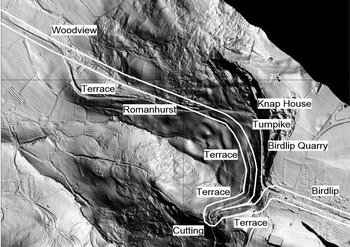
(7) Great Witcombe (SO 925 144–SO 913 152): Lidar imagery has confirmed the line of the Roman road (Margary 41c)Footnote 323 as it descends Birdlip Hill to the west of the modern A417. This is an important example of the technique used by Roman engineers in coping with steep ascents and descents. The surviving Lidar and ground evidence shows that the Roman road approaching from Cirencester turns south-west as it reaches the escarpment in Birdlip at SO 925 144 in order to utilise an east–west spur of the escarpment to reduce the overall gradient by running west for 400 m and then turning back east for 400 m in order to lose height without moving too far away from the desired road line (fig. 36). This involved a descent of c. 40 m in height while only moving 200 m laterally to the west from the first change of direction, a very efficient course to adopt to lessen the gradient of the descent.
Annotated Lidar imagery of the Roman road (Margary 41c) between Birdlip and Woodview, Great Witcombe. (© The Environment Agency)

The Roman road then curves down the slope west of and below the modern road through woodland to emerge into pasture west of Birdlip quarry at SO 923 146. In the pasture field to the north it is joined by an early turnpike line descending from the modern road line at SO 923 148. The Roman road then crosses the modern road 500 m east of Romanhurst at SO 921 148 and runs to the north-east of the modern road for c. 850 m to rejoin it to the north-east of Great Witcombe at Woodview (SO 913 152). It is likely that it followed a direct course here rather than a curved route as shown by the Ordnance Survey, but the Lidar imagery is not clear enough to confirm one way or the other.Footnote 324
(8) Kemble, land at Top Farm (ST 9868 9700): an excavation recorded a cremation grave containing Roman pottery and an iron nail located 8 m from an undated cremation uncovered in a previous evaluation. Two parallel ditches which yielded pottery dating from the first to the fourth centuries were also present.Footnote 325
(9) Somerford Keynes (SU 0209 9489): an evaluation recorded a series of Roman ditches and pits believed to be within, or at the periphery of, a Romano-British farmstead or rural settlement. Varying in size and depth, most of the linear features generally corresponded with anomalies identified by a geophysical survey undertaken prior to trench investigation, although more features were revealed during the evaluation than anticipated by the survey. With the exception of part of a third- to fourth-century enclosure ditch, the features uncovered dated to the second century and represented mainly enclosure and boundary ditches. The pottery assemblage yielded by the majority of the features was dominated by a diverse range of ‘local’ coarsewares, most, or all of which are likely to have come from the poorly documented Wiltshire pottery industry, while the remains of working animals were recovered from contexts dated to the Romano-British period. The CBM assemblage, though limited in the number of fragments recovered, appears to indicate the presence of a Roman structure, complete with hypocaust system, within or close to the site.Footnote 326
(10) Tetbury, Highfield Farm (ST 8941 9418): an excavation revealed three broadly contemporary late Iron Age/early Roman transition period rectilinear enclosures. The finds from the enclosure ditches are suggestive of settlement in the vicinity, with the enclosures themselves most probably having been stock-pens.Footnote 327
BRISTOL
(1) Lockleaze, Ding's Crusaders (ST 6093 7769): an evaluation and excavation identified the remains of a late Iron Age/early Roman transitional period settlement and subsequent multi-phase Roman villa. The earliest remains were of a late Iron Age oval enclosure which surrounded a roundhouse. Roman activity began in the first to second century with the creation of fields, paddocks and droveways defined by ditches, all apparently bounded to the west by a substantial ditch. Two graves also date to this period, as does a timber building containing at least two rooms, which was later replaced by the main residence associated with the extensive remodelling of the settlement in the second to third century, when a villa complex was constructed over the earlier settlement. This included a main house which underwent at least three phases of extension, including the installation of heated floors and a kitchen, with a walled courtyard in front, beyond which was a secondary courtyard containing ancillary buildings which are likely to have been used for agricultural and industrial processing, including lead-smelting. After the decline of the villa in the early to mid-fourth century, there was extensive robbing of the walls, although the date at which this occurred is unclear.Footnote 328
BATH AND NORTH-EAST SOMERSET
(1) Bath, Saw Close (ST 7490 6483): an excavation identified two small pits and a gully containing finds broadly dated to the Roman period. These were sealed by the make-up for mosaic, opus signinum and stone floors and associated wall footings. Within a separate excavation area, in close proximity to the probable alignment of the north-west section of the Roman town wall, remnants of deposits probably relating to the earlier defensive ramparts were partially exposed and produced Roman ceramic building material, tesserae, slag and mortar.Footnote 329
SOMERSET
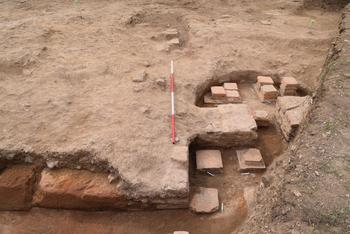
(1) Brympton, Lufton Villa (ST 5160 1790): further excavation as part of the Lufton projectFootnote 330 has shown that the archaeological sequence is much more complex than previously suggested by Hayward.Footnote 331 Re-excavation of the southern part of the late Roman villa identified a structural phase pre-dating the ‘Haywardian villa’. A flue lined with substantial fire-reddened hamstone blocks fed a hypocaust within an apsidal room, which underwent some modifications during its life (fig. 37). The later villa structure, robbed in this area, would have overlain the earlier (probably third-century) building. The flue contained a coin of Crispus (a.d. 318–24) which might indicate the date at which the hypocaust room went out of use.
Lufton Villa: apsidal room with hypocaust (probably third century) with flue in foreground. (Photograph: Andrew Agate)

Reinvestigation of Hayward's Rooms 3 and 4 showed that he had completely excavated these spaces, removing all archaeological deposits (including mosaics) to below the foundation courses of the walls. In the backfill of these trenches a plano-convex lead ingot (c. 37 kg) was recovered. The rear wall of the villa north of the internal partition between Rooms 4 and 5 proved to have been demolished before it was sealed by a deposit of smashed lias roof-tile. This suggests the building was shortened, leaving the southern rooms (Rooms 2, 3, 4 and parts of Room 1) standing. Further evidence for structural alterations include walls of herringbone masonry that block the corridor (Room 1) in line with the northern and southern walls of Room 2. Neither of these walls was recorded by the previous excavator.
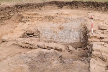
Hayward did record ‘hearths’ immediately north of the southern wall crossing Room 1. On reinvestigation, these proved to be a thick deposit of interleaving burnt layers with the remnants of an ‘oven’ or ‘grain drier’ flue at the top of the sequence. The fill of this flue contained a burnt sherd of BB1 from a Type 18 bowl. This suggests use in the first half of the fifth century.Footnote 332 The area to the north of Room 2 was interpreted by Hayward as an external space. Excavation in this area revealed a small room with a plain grey tessellated pavement (fig. 38). Overlying this was a thin black deposit containing oyster shells and a late Roman bone hairpin.
Lufton Villa: small and previously unknown room with tessellated pavement north of Room 2. (Photograph: Andrew Agate)

In summary, there is almost certainly a third-century or earlier precursor to the building excavated by Hayward. The fourth-century structure appears to have undergone significant modifications but their precise chronology and how the sequence can be correlated with the previous excavator's understanding of the site remains to be resolved.Footnote 333
(2) Carhampton, Sea Lane End, Dunster Beach (ST 0057 4433): magnetometer and earth resistance surveys were carried out after members of Dunster Museum Archaeological Group identified numerous sherds of Romano-British pottery eroding from the field edge bordering the beach. Following a monitoring and recording training project, organised by the Coastal and Intertidal Zone Archaeological Network (CITiZAN), which established that these were emanating from an eroding ditch, a geophysical survey was arranged to investigate the field immediately inland of and adjacent to the pottery finds to better establish the extent and nature of the site. Both magnetic (1.5 ha) and earth resistance (0.7 ha) surveys identified a number of linear anomalies, morphologically representative of field boundaries, enclosures and trackways.Footnote 334 These are potentially Roman in date although no obvious Romano-British building structures were located. It is clear that a proportion of the site has already been lost to coastal erosion, so the geophysics will have produced an incomplete picture at best.Footnote 335
(3) Chaffcombe: hoard of 109 sestertii and lower denominations ranging from a Claudian copy of mid-first-century date through to Julia Domna (Wars of Succession a.d. 193–8). Date of deposition c. a.d. 195.Footnote 336
(4) Faulkland, land east of Fulwell Lane (ST 7380 5435): excavation revealed a rural settlement comprising two enclosures which yielded a large finds assemblage suggestive of occupation, although no structures were present. The enclosures were in use from the early Roman period, and perhaps earlier, until c. a.d. 200 when the ditches were deliberately infilled. They were replaced by shallow ditches defining fields likely to be of late Roman date. The site contained three Roman burials, comprising two inhumations and a single cremation, which may have been closure deposits.Footnote 337
(5) Frome (III): hoard of 11 AE radiates with a deposition date of c. a.d. 274.Footnote 338
(6) Kingsdon: hoard of 3 radiates and 282 nummi. The 3 radiates were 1 of Divus Claudius II (a.d. 270) and 2 of Tetricus I (a.d. 271–4). The nummi ranged from a.d. 321–3, BEATA TRANQVILLITAS (Trier), through to a.d. 395–402 (Arcadius or Honorius – Rome or Aquileia). Date of deposition c. a.d. 402.Footnote 339
(7) Merriott: hoard of 7 base metal radiates and 122 nummi. The radiates included 2 of Probus (a.d. 276–82), 2 of Carausius (a.d. 286–93) and 2 of Diocletian (a.d. 284–305). The hoard closed with nummi of a.d. 353–4. Date of deposition c. a.d. 354.Footnote 340
(8) Nether Stowey: 3 silver denarii: 1 of the Republic, 1 of Augustus, (31 b.c.–a.d. 14) and 1 of Domitian Caesar under Vespasian (a.d. 69–79). Date of deposition c. a.d. 79.Footnote 341
(9) Westbury: hoard of 90 AE radiates, the latest coins being those of Tetricus I (a.d. 271–4). A greyware basal sherd together with some minor fragments might potentially have been the coin container, though fragments of more than one pot were present. Date of deposition c. a.d. 274.Footnote 342
(10) Westbury-sub-Mendip: hoard of 188 silver denarii. The earliest are 10 denarii of Mark Antony (32–1 b.c.). The last coins are two of the initial legionary issues of Septimius Severus (Wars of the Succession, a.d. 193–7). A large number of pot sherds from several vessels were also recovered. Date of deposition c. a.d. 193.Footnote 343
(11) Withycombe: 6 Tetrarchic nummi (mostly fragmentary), all probably a.d. 294–305. Date of deposition c. a.d. 305.Footnote 344
DEVON
(1) Aveton Gifford: hoard of more than 43 base metal radiates (including fragments) deposited c. a.d. 274.Footnote 345
(2) Dean Prior: a purse group (not treasure) of 4 sestertii, all of Claudius (a.d. 41–54), deposited c. a.d. 54.Footnote 346
(3) Exeter: (a) Exeter and Devon Crematorium, Topsham Road (SX 9379 9072): an excavation was undertaken contiguous to the site of a probable mid-first-century Roman military supply depot previously excavated on the site of the former St Loye's College.Footnote 347 Evidence was recovered for likely Roman military occupation extending to the south-east, beyond the defences of the St Loye's complex. This evidence took the form of the recovery in plan of part of two timber-built, post-trench buildings of probable military date and a ditch which post-dated one of the buildings. The south-east section of the defensive circuit of the Roman military establishment, seen at St Loye's, was absent from the area of excavation here, while an additional trench located at the south-west corner of the site indicated that the projected line of the defensive circuit of the St Loye's complex would lie within an extant hollow way parallel to the north-west boundary of the crematorium site.Footnote 348 The site at the Exeter and Devon Crematorium and that of its neighbour at St Loye's College are due to be published together in one paper.Footnote 349
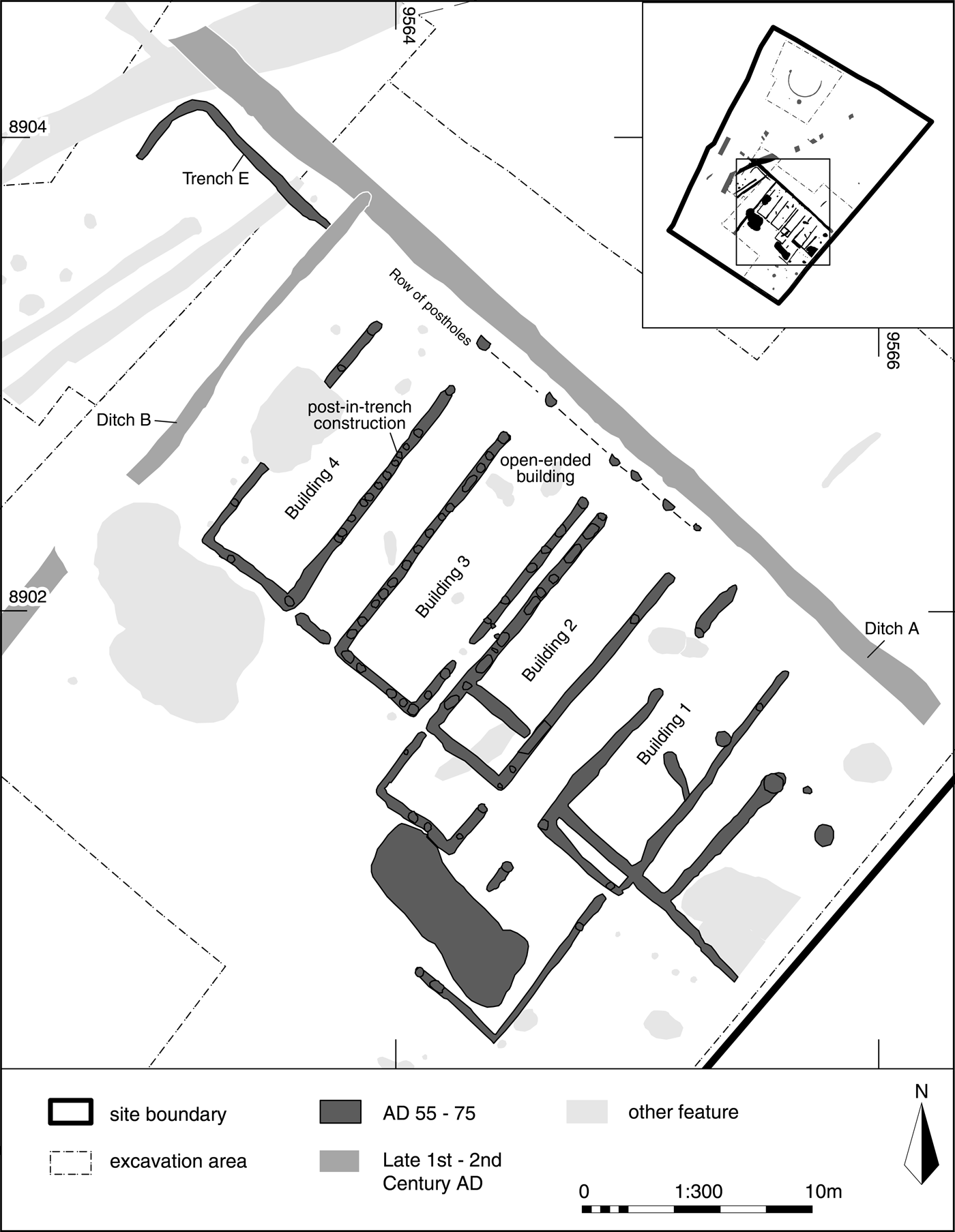
(b) Exeter Road, Topsham (SX 9565 8905): the remains of four early Roman rectangular timber-framed buildings (1–4), each measuring 12 m long and 4 m wide, were recorded during small-scale excavation ahead of the construction of a supermarket (fig. 39). The buildings were of post-in-trench construction and lay parallel to the line of a presumed Roman road located c. 40 m to the north-east. Openings along the north-eastern side of each building may represent entrances to allow the loading of goods from an open yard that lay adjacent to the Roman road. A row of six shallow post-holes was uncovered parallel to the north-eastern edge of each of the buildings, possibly representing a veranda or fence line. The structures were constructed in a military style and, based on the presence of a small assemblage of pottery, were dated to a.d. 55–75.
Exeter, four parallel timber-framed buildings plus other features located to the south-west of the Roman road from Topsham to Exeter. (Drawn by Aleksandra Osinska. © Cotswold Archaeology)

The structures may have formed part of a small unenclosed storage complex. At some point in the late first to early second century, a phase of Roman civil occupation was indicated by two ditches which respected the line of the rectangular buildings and possibly represented a small field-system. Although no dating evidence was recovered from the ditches, each was stratigraphically later than the buildings above and one (Ditch A) extended to the south-east into an area excavated ahead of the construction of the M5 motorway.Footnote 350 The connection between these two sites may suggest that the field-system formed part of a wider area of agriculture established in this period. The site was abandoned at some point in the second to third century.Footnote 351
(c) Wessex Close, Exeter Road, Topsham (SX 9583 8891): an excavation in three phases was completed in 2016; this revealed the stone foundations, associated remains and the full plan of an aisled Romano-British building dating probably from the second to third century. It had a portico on the south-west side, suggesting that it faced towards the river Exe and not in the opposite direction where the rear of the building was adjacent to the Roman road from Topsham to Exeter. A separate stone-lined structure is likely to be the remains of a furnace room, hinting that there might be an associated bath-house in an area not investigated. There was also evidence for two post-trench structures of Roman military type and a 5.6 m deep well lined with reused roof-slates. A large quantity of finds was recovered, including an Eastern Mediterranean polychrome glass bowl and imported pottery. Other Romano-British features on the site dated to the first century and comprised a series of land division ditches on mainly north-west to south-east alignments.Footnote 352
(d) Bishop's Court extension, Sidmouth Road (SX 9616 9120): excavation revealed a general background of prehistoric activity with a storage pit and residual pottery sherds retrieved from Romano-British features. The main phase of activity was Romano-British, comprising two possible timber post-built structures and two ovens, located within a partially exposed coaxial field-system which appears to take its alignment from the Exeter–Charmouth Roman road, located to the north of the site.Footnote 353
(e) St David's church (SX 9152 9309): a watching-brief identified the remains of Roman tile kiln waste, dated from the associated samian and mortaria sherds to c. a.d. 50–85. The site of the discovery was c. 200 m north-west of the porta principalis dextra of the legionary fortress at Exeter which was occupied c. a.d. 55–75.Footnote 354 It is possible that there were smaller baths built after c. a.d. 70 somewhere in the very extensive complex of defended enclosures which surrounded the fortress, and that the kiln supplied materials for their construction. Equally possible is an association of the kiln with the reduction in size of the fortress baths following the departure of the legion in c. a.d. 75. The alterations might have required new materials, such as tegulae, imbrices and pilae, to replace parts of the roofs and heating systems.Footnote 355
(4) Ipplepen, Dainton Elms Cross (SX 84 66): an open-area excavation and two further evaluation trenches (11–12) investigated the area immediately west of the late Roman ditch in Trench 9 excavated in 2015.Footnote 356 A sequence of circular gullies represents a series of roundhouses dating from the middle Iron Age through to the Roman period. Nearby features included various ditches, pits and two possible wells (neither bottomed). The Romano-British occupation in this part of the site ran from the mid-first through to the third century. Large amounts of domestic refuse were recovered including charred cereal and faunal remains. The pottery included significant amounts of material imported from the Continent (including Gaul, the Rhineland and the Mediterranean).Footnote 357
(5) Whiddon Down: hoard of 1 silver denarius and 91 sestertii (addenda to recorded Whiddon Down Hoard).Footnote 358 The denarius is of Hadrian (a.d. 117–38). Sestertii down to a.d. 180. Later stray coins from the same findspot extend the terminus post quem of deposition to a.d. 198.Footnote 359
CORNWALL
(1) St Levan II: hoard of 179 AE sestertii and fractions deposited c. a.d. 261. St Levan II is clearly a discrete deposit whose pit lies some distance away from St Levan I.Footnote 360 Both were late sestertius hoards.Footnote 361
(2) St Levan III: hoard of 13 base metal radiates deposited c. a.d. 282.Footnote 362
(3) St Levan IV: 7 AE dupondii and asses (plus 4 coins recorded individually). Date of deposition c. a.d. 111.Footnote 363
(4) St Levan V: hoard of 14 Iron Age gold staters and 8 quarter staters and 18 Roman denarii. 11 of the 14 gold staters were inscribed, these being: one BODVOC stater, one CORIO stater, one COMVX tree stater, one CATTI tree stater, one uncertain Catti or Inamn stater and six ANTED rig staters; none of the quarter staters were inscribed. The denarii included: 9 of the Republic, 1 of Antony (32–1 b.c.); 1 of Augustus (31 b.c.–a.d. 14); 2 of Caligula (a.d. 37–41); 1 of Claudius (a.d. 41–54); and 1 of Galba (a.d. 68–9), which was the latest coin associated with the hoard. Two minor fragments of Roman pottery were also recovered. Date of deposition c. a.d. 69.Footnote 364