Introduction
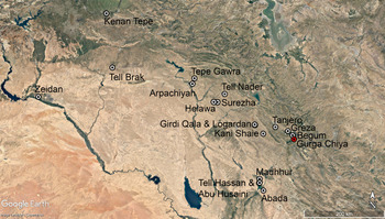
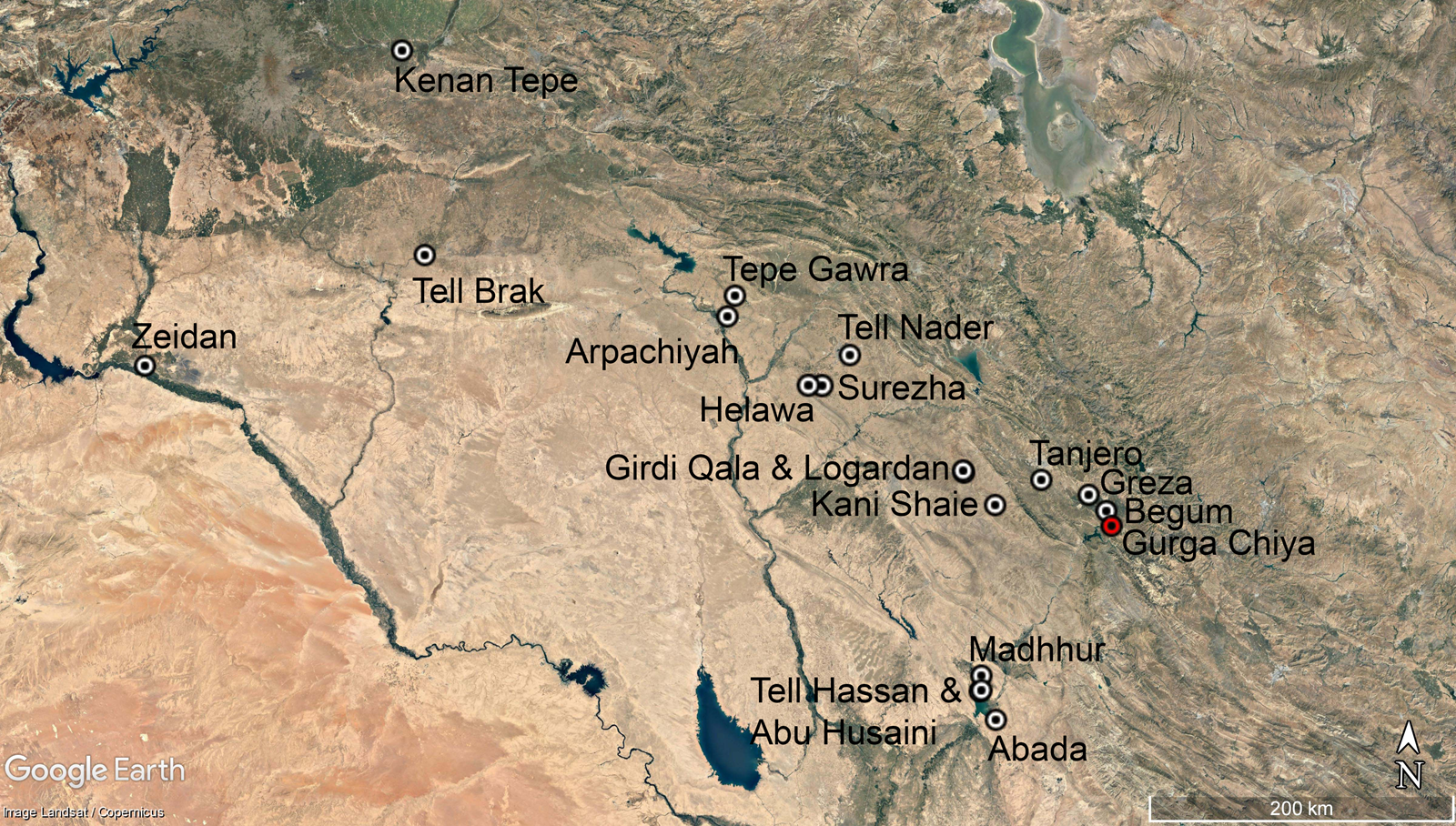
The Shahrizor Prehistory Project was initiated in 2012 to investigate the later prehistory of the Kurdistan region of Iraq, through a combination of excavation, survey, and environmental analysis in the Shahrizor Plain.Footnote 1 Its research goals are oriented around the investigation of two small (c. 1 ha) adjacent mounds, Gurga Chiya and Tepe Marani, facing the foothills of the Zagros Mountains on the modern border between Iraq and Iran, near the town of Halabja (Fig. 1). In a first preliminary report (Wengrow et al. Reference Wengrow, Carter, Brereton, Shepperson, Hamarashi, Saber, Bevan, Fuller, Himmelman and Sosnowska2016) we described the main characteristics and local environment of these previously unexplored sites, situating them within the wider history of archaeological research on the Shahrizor Plain. Our first two seasons of work (2012 and 2013) established the main sequences of habitation, including the identification of Ubaid period and Middle Uruk period levels at Gurga Chiya, and Late Neolithic (Late Halaf) remains at Tepe Marani, as well as Late Bronze Age occupation at the former site (Wengrow et al. Reference Wengrow, Carter, Brereton, Shepperson, Hamarashi, Saber, Bevan, Fuller, Himmelman and Sosnowska2016). Until recently, these periods have been mainly documented from surface survey in this southeastern part of Iraqi Kurdistan (Mühl 2013).
Map showing key sites discussed in the text. Google Earth Pro V 7.3.2.5491 (July 23, 2018). Northern Mesopotamia. 35° 43´ 20.05˝ N, 42° 57´ 47.33˝ E, Eye Altitude 825.87 km. Landsat/Copernicus. [March 5, 2019].
Simultaneously, environmental work to reconstruct the pre-modern landscapes of the Shahrizor Plain is now well advanced (Altaweel et al. Reference Altaweel, Marsh, Mühl, Nieuwenhuyse, Radner, Rasheed and Saber2012; Marsh et al. Reference Marsh, Fleitmann, Al-Manmi, Altaweel, Wengrow and Carter2018), providing opportunities for linking regional data on climate change and land formation during the sixth-fifth millennia B.C. to the detailed results of excavation. This has revealed a complex mosaic of early to middle Holocene environments in the vicinity of Gurga Chiya and Tepe Marani, with arable soils unevenly dispersed among areas of grass, woodland, and marsh. Sites of these early periods – including those discussed here – were located on Pleistocene terraces overlooking watercourses, fed by run-off from the surrounding highlands and by c. 7–900 mm of annual precipitation, far in excess of rainfall levels in neighbouring parts of the Middle East. The same environment during the early to mid-Holocene has been detected around the nearby site of Tell Begum, which is also likely to have been located on a Pleistocene terrace (Nieuwenhuyse et al. Reference Nieuwenhuyse, Odaka, Kaneda, Mühl, Rasheed and Altaweel2016: 106–109).
The 2014 season at Gurga Chiya and Tepe Marani had two main objectives. Our primary aim was the further exposure of late prehistoric levels at both sites, extending the findings of the first season and following the same recovery protocols for organic remains and micro-artefacts (Wengrow et al. Reference Wengrow, Carter, Brereton, Shepperson, Hamarashi, Saber, Bevan, Fuller, Himmelman and Sosnowska2016). Additionally, we sought to link the development of these sites to wider patterns of environmental change, as demonstrated by geological coring, speleothem analysis, and other types of proxy data from the Shahrizor Plain. A geophysical survey was undertaken on the shallower mound of Tepe Marani, to better determine the extent and preservation of architectural and landscape remains below the plough-soil, and particular attention was given to the recovery of environmental remains and aspects of material culture that might reflect distinctive features of the early-middle Holocene environment.
The main outcomes, described in detail below, include the discovery at Gurga Chiya of a complex of rooms with partially preserved pisé walls, dating to the mid-to-late fifth millennium B.C., or Late Ubaid period, and associated with a rich assemblage of botanical remains. These organic remains constitute the first Ubaid-period botanical assemblage of any scale from this region, shedding new light on late prehistoric farming and storage practices and allowing comparison with the small number of similarly dated assemblages from further afield, most notably at Kenan Tepe in southeastern Turkey (Graham Reference Graham2011).
In this report we focus on the stratigraphic and architectural remains, the ceramics from Gurga Chiya, and the archaeobotanical remains from both sites. Despite the sieving and flotation programme, the number of small finds from either site was limited during the 2014 season and did not add to the previously published range, while the faunal and lithic assemblages remain small and will be presented once they are augmented through further excavation.
LC4 Period (Late Middle Uruk) at Gurga Chiya
LC4 Stratigraphy and Structures
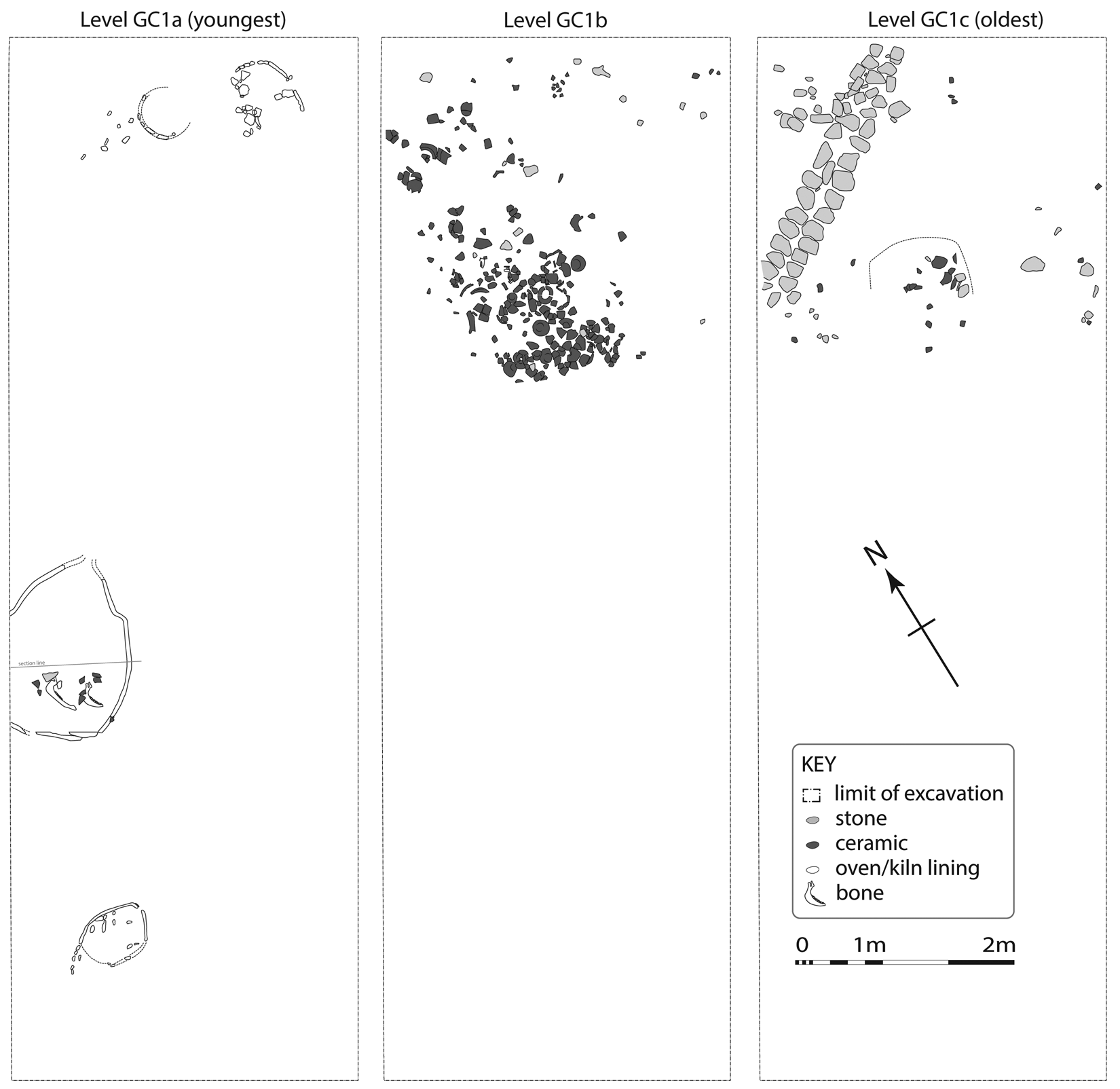
During 2014, the two trenches (E and F) from the previous season were linked by a further 4m x 4m square (G), forming a single 12m × 4m trench. Three superimposed Late Chalcolithic 4 (hereafter, LC4) subphases of this trench are shown on Fig. 2; the fourth (Level 1d) is not depicted as it contained no features.
Levels 1a-c at Gurga Chiya.
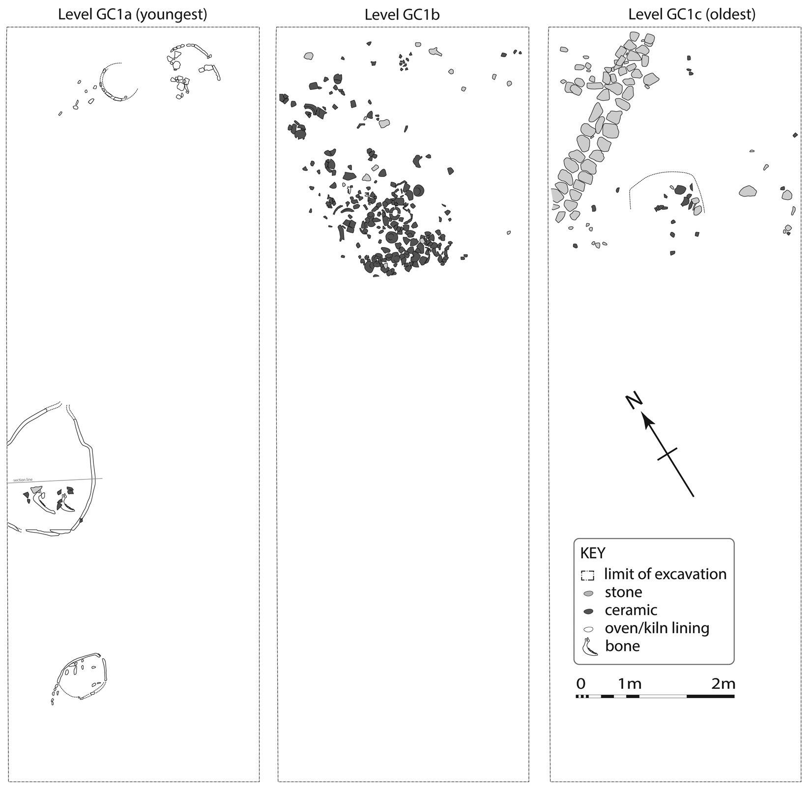
Here, the LC4 (cf. Late Middle Uruk) levels at Gurga Chiya were already known to include a level of truncated ovens or kilns (Level 1a; Wengrow et al. Reference Wengrow, Carter, Brereton, Shepperson, Hamarashi, Saber, Bevan, Fuller, Himmelman and Sosnowska2016: 261–262). Stratigraphically below this in Trench F lay a dense scatter of LC4 pottery (Level 1b), deposited above the remains of an earlier stone wall (Level 1c). Under the wall were a series of relatively homogeneous deposits, probably comprising a levelling fill. This contained a mixture of Late Ubaid and LC4 pottery, indicating that a LC4 occupation already existed at the site before the levelling activity.
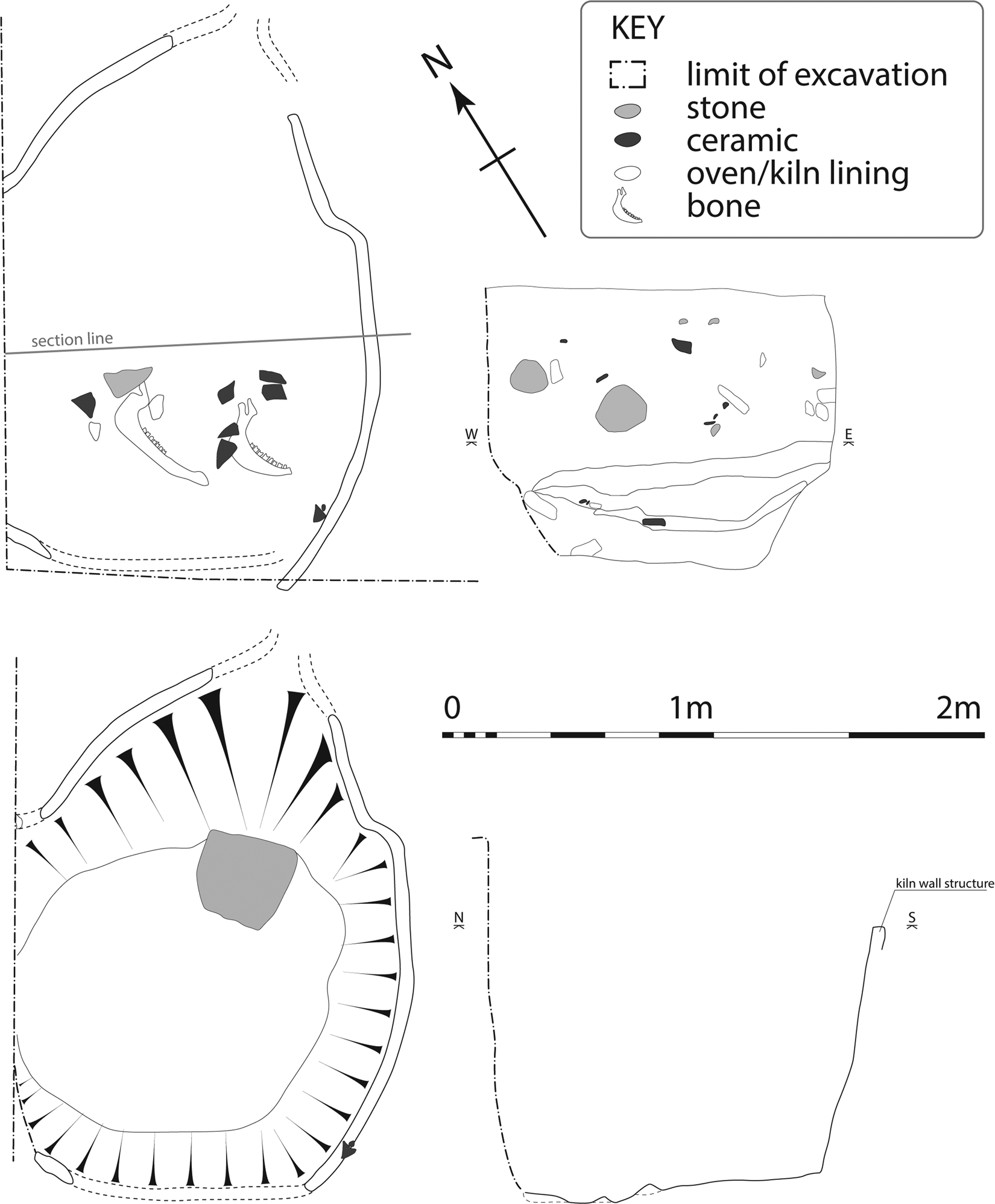
During the 2014 season, the chief addition to our understanding of the LC4 occupation was the full exposure of the lower parts of a large burnt, clay-lined pit feature belonging to Level 1a. We interpret this feature as a poorly preserved pottery kiln (Fig. 3). It was oval in shape, with a maximum diameter of two meters, and indications of a flue on the northeast side. The kiln lining was reddish and highly friable. No internal structure survived. Several fills were present, including a lower deposit with bovine mandibles and LC4 pottery, considered to be secondary usage (trash dumping).
LC4 Pottery kiln (Level 1a) at Gurga Chiya.
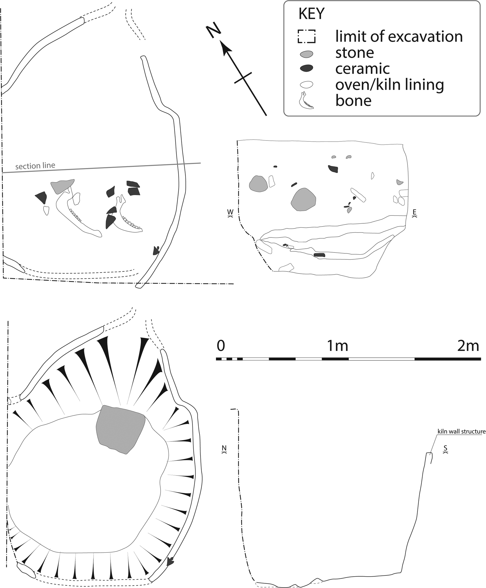
The best indications regarding its function are derived from comparisons in construction and size with LC and earlier pottery kilns from various sites in Mesopotamia, including Ubaid examples at Abada and Songor B (Jasim Reference Jasim1985: 51, 155, fig. 36), and LC/Uruk period examples at Kenan Tepe, Brak and Abu Salabikh (Foster Reference Foster2009: 179; Felli Reference Felli and Matthews2003 fig. 4.2; Postgate & Moon Reference Postgate and Moon1982: 105, 120). A major complex of large pottery kilns with comparable dimensions, albeit better preserved and with thicker surviving walls, is found in several Uruk Period levels at Girdi Qala, in the Qara Dagh region (Vallet et al. Reference Vallet, Baldi, Naccaro, Rasheed, Saber and Hamarasheed2017: 69–74). These parallels leave little doubt that the feature at Gurga Chiya is the combustion chamber of a pottery kiln.
LC4 Ceramics: Ware and Form Frequencies
LC4 strata are found in a thick layer running across the whole of the conjoined trench. A selection of LC4 pottery is presented below. For previous examples, including Bevel Rim Bowls (henceforth BRBs), lugged jars and cannon-spouted jars, see Wengrow et al. Reference Wengrow, Carter, Brereton, Shepperson, Hamarashi, Saber, Bevan, Fuller, Himmelman and Sosnowska2016: fig. 8. The LC4 assemblage relates closely to that of the southern Late Middle Uruk, but we do not observe any technological contrast between a “Southern Mesopotamian mineral tradition” and earlier or contemporary local LC pottery (chaff tempered). Rather we note that the LC4 wares are almost exclusively vegetal tempered (see individual ware discussions below), albeit with finer vegetal temper than is seen in the Late Ubaid.
Percentages of wares and forms presented below are based on Rim Sherd Counts of material identified as LC4 in Level 1a-d, which yielded a total of 429 Rim Sherds. The combined count of all registered diagnostic sherds for these LC4 phases (following the exclusion of plain body sherds during initial processing) was 932; the additional material includes a significant amount of older residual material (Late Ubaid), as well as sherds of uncertain chronological attribution, plus decorated body sherds of various dates.
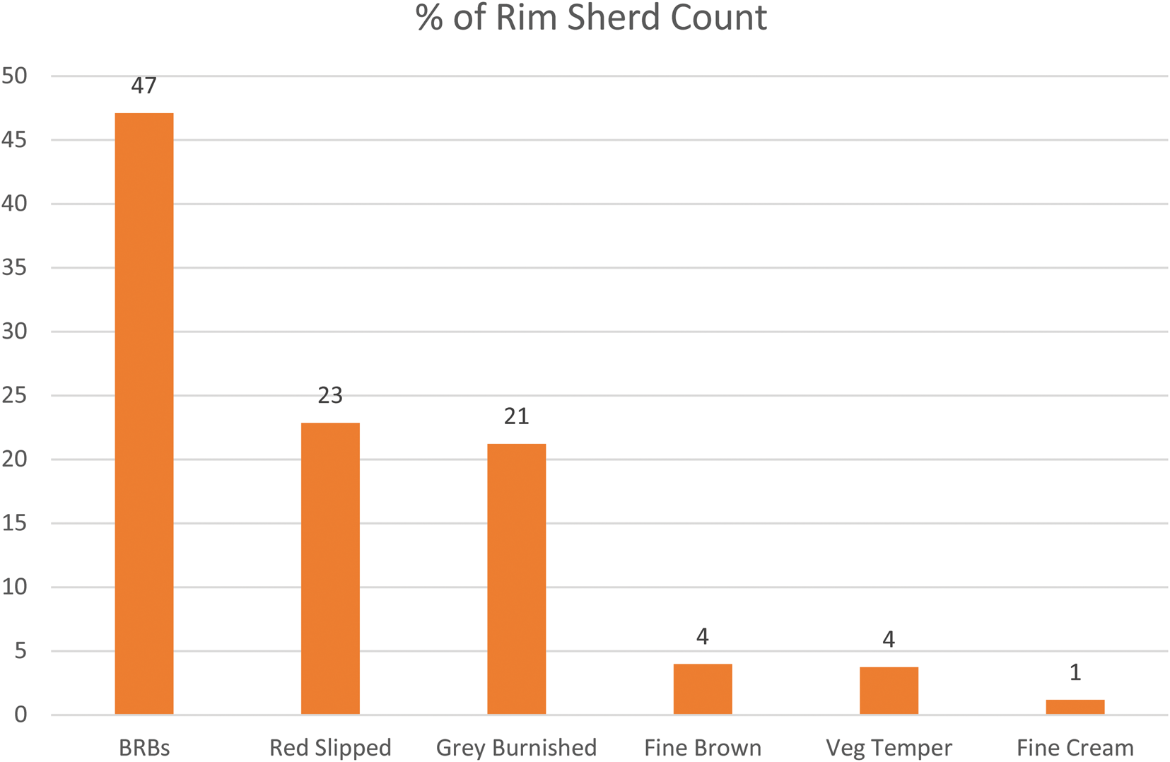
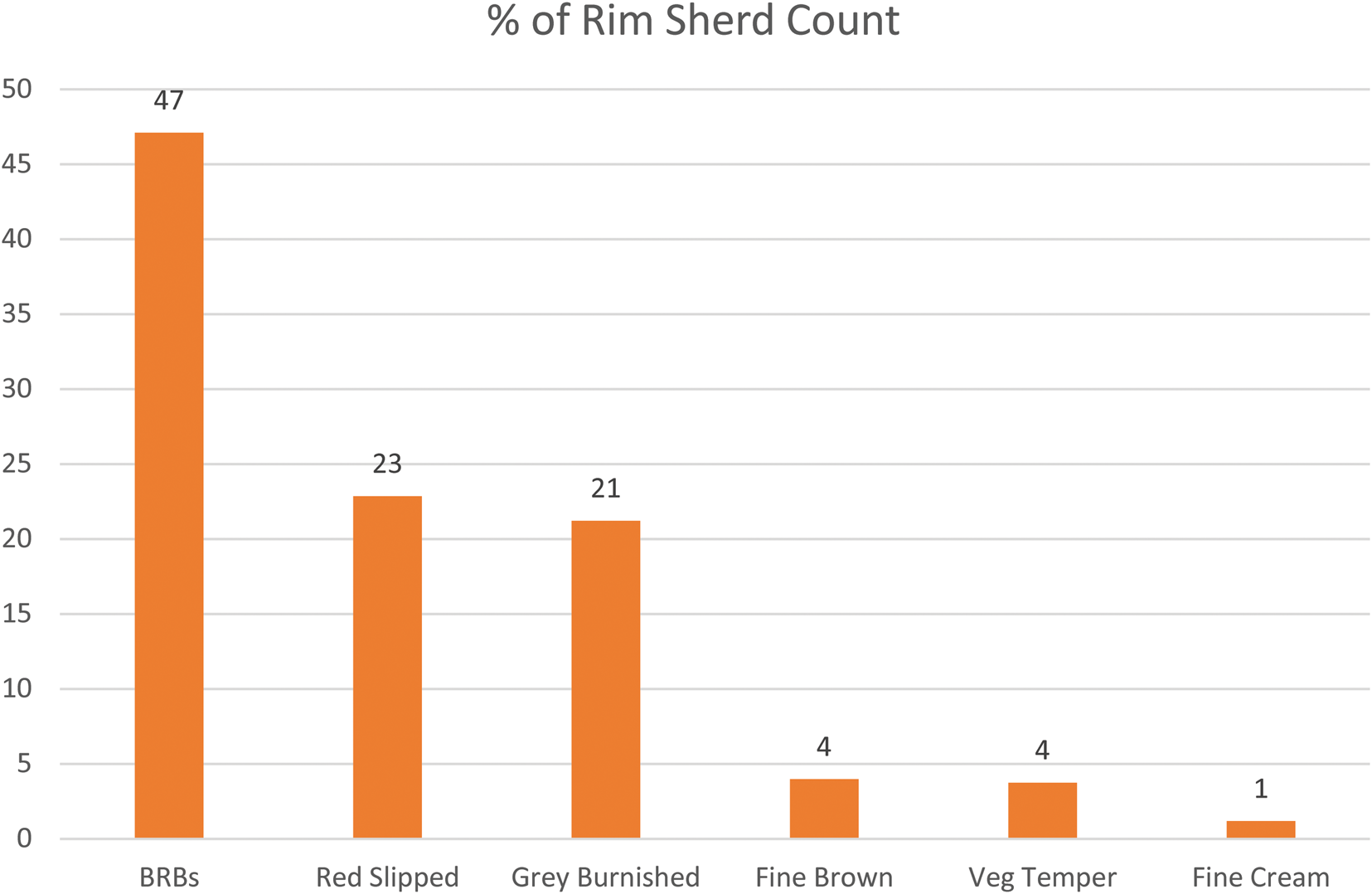
Regarding macroscopic ware frequencies (Fig. 4), the LC4 assemblage is dominated by a coarse ware associated with BRBs, with a variable fabric of both vegetal and mineral inclusions (47%).Footnote 2 Red Slipped and Grey Burnished wares make up most of the rest of the assemblage, while Fine Brown and Fine Cream wares, used for spouted jars, smaller bowls and cups, is less common. One category, “Vegetal Tempered ware”, is problematic as it may include older residual pottery (see individual entry on this ware below). However, we are confident that the majority of vessels in this ware are LC4 in date. Further work is required to compare the wares assigned at Gurga Chiya with those recently defined (although slightly earlier, LC2–3) at Girdi Qala, including the relationship between fabric groups and manufacturing techniques (Vallet et al. Reference Vallet, Baldi, Naccaro, Rasheed, Saber and Hamarasheed2017: 75–76).
Percentages of LC4 ceramic wares at Gurga Chiya, Levels 1a-d combined.
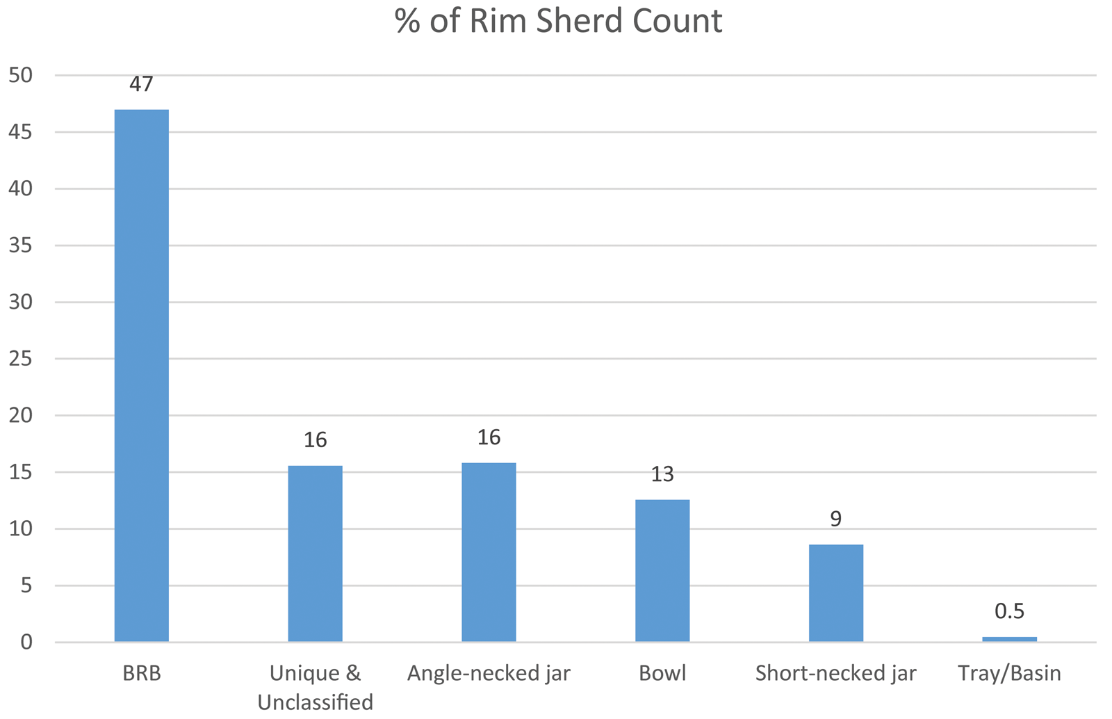
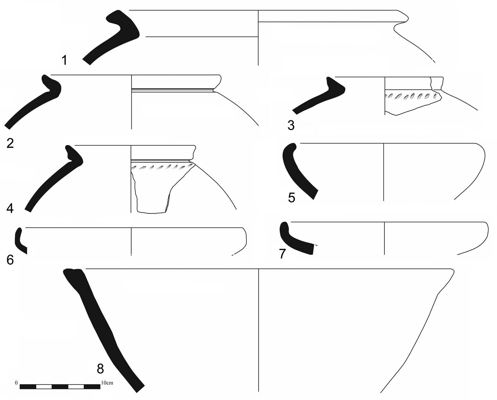
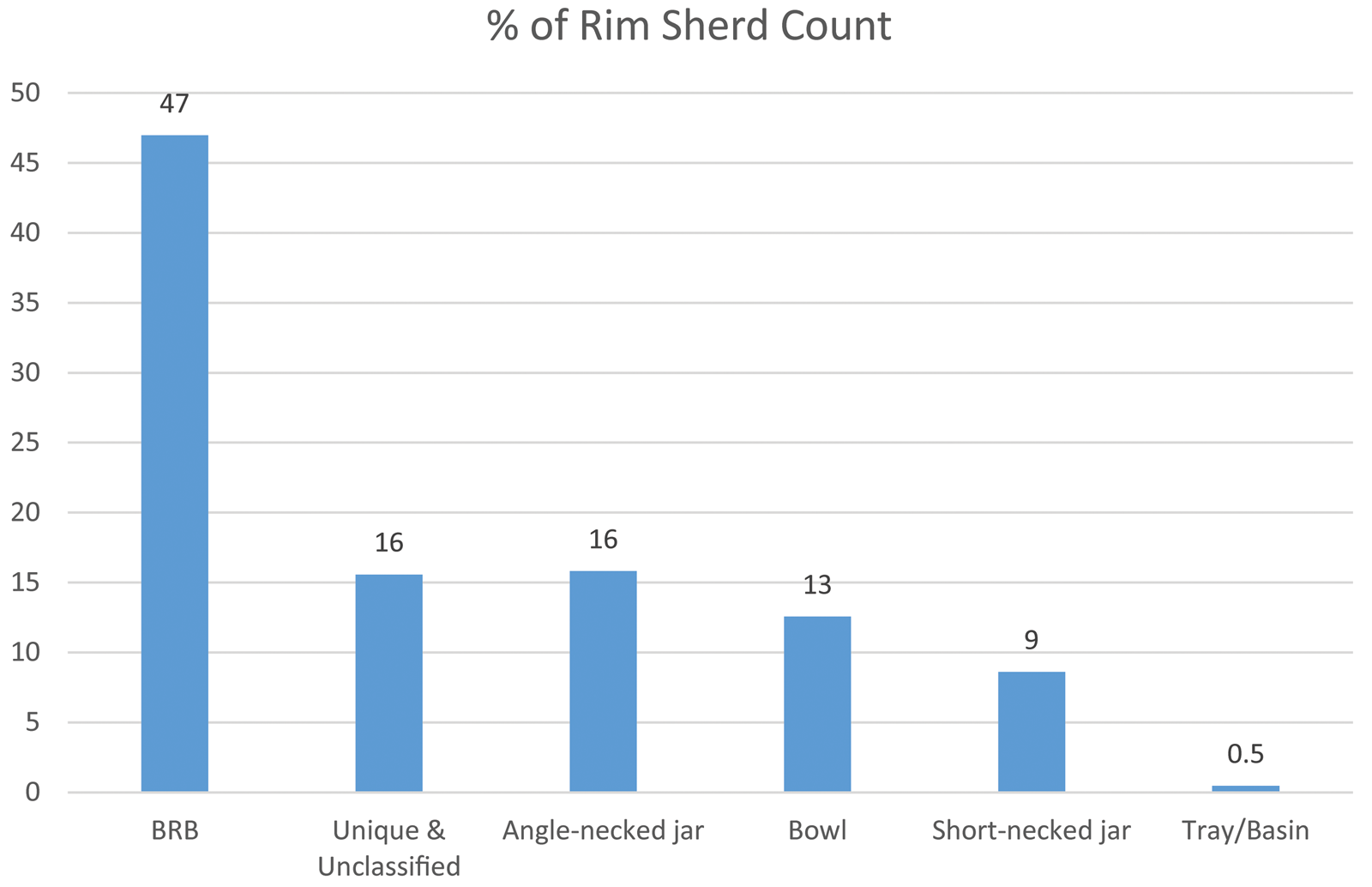
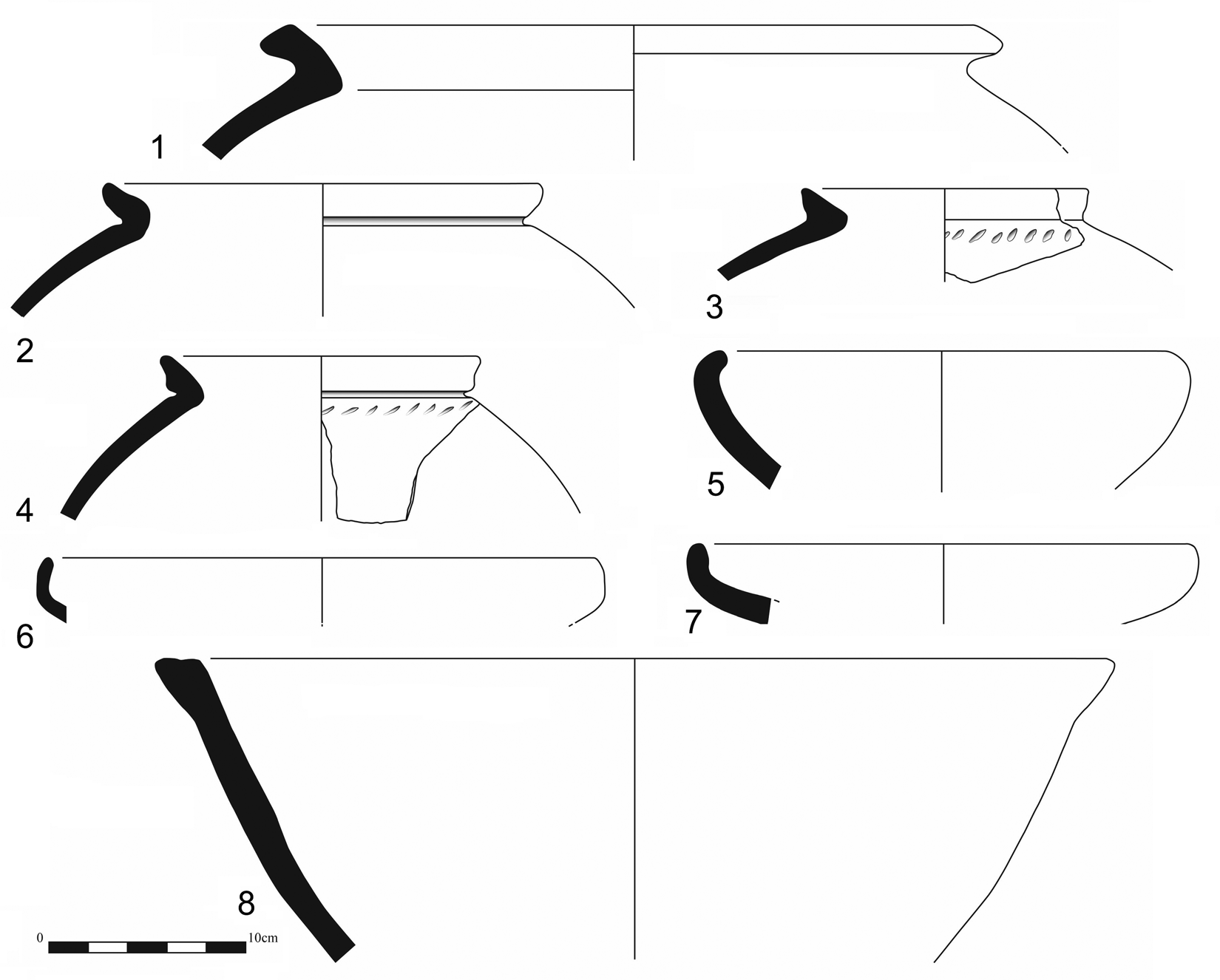
Regarding forms, BRBs again dominate the assemblage (Fig. 5). The next most commonly represented form, at 16%, is a variety of angle-necked cooking pot (not illustrated, but see Wengrow et al. Reference Wengrow, Carter, Brereton, Shepperson, Hamarashi, Saber, Bevan, Fuller, Himmelman and Sosnowska2016: fig. 8: 4), mostly in Grey Burnished ware. A variety of different bowls, in a range of sizes, combine to contribute 13% of the assemblage, most notably including bowls with incurved rims (Fig. 6: 5–7), representing 5% of the Level 1 assemblage. Closed jar forms with short necks and various rim shapes (Fig. 6: 1–4) together make up c. 9% of the assemblage, mainly in Red Slipped ware. The forms and formal parallels are discussed in more detail below, according to ware.
Percentages of LC4 forms at Gurga Chiya, Levels 1a-d combined.
LC4 pottery from Gurga Chiya, Levels 1a-d. Nos. 1, 5, 6, 8: Red Slipped. Nos. 2, 3, 7: Fine Brown. No. 4: Grey Burnished.
LC4 Ceramics: Ware Categories and Parallels
BRBs and BRB Ware
As with the majority of Uruk period sites, BRBs are the most common ceramic form and fabric in the LC4/Late Middle Uruk levels at Gurga Chiya. Their frequency at 47% is similar to the 40% seen at Tell Rubeidheh (McAdam and Mynors Reference McAdams, Mynors and Killick1988: 39), and 44% at Tell Hassan (Nannucci Reference Nannucci and Mazzoni2012: 43).
At Gurga Chiya vessel sizes are variable, with rim diameters of 12cm–28cm, and mean and modal diameters of 18cm and 19cm respectively. This variation is paralleled at Rubeidheh (McAdam and Mynors Reference McAdams, Mynors and Killick1988: Table 4). They are handmade with a coarse, often cracked, surface. Medium and coarse vegetal temper, probably chaff, is the norm, with variable quantities of naturally occurring mineral inclusions. The colour varies, mainly being pale greyish brown. It appears most likely that they were constructed using moulds, perhaps older BRBs.
Red Slipped Ware
This is the second most common LC4 ware, at 23%. Fabric colour ranges from red through to pinkish red, sometimes tending to grey, and a darkened grey core is common. The surface is slipped and often shows signs of burnish; both slip and burnish are often uneven and streaky. Inclusions consist of a moderate amount of medium vegetal temper, and occasional small grey angular mineral inclusions. As noted at other Iraqi sites (especially Qarashina and Kamarian), Uruk Red Slipped ware dominates Uruk period assemblages in the region (Abu al-Soof Reference Abu al-Soof1985: 86).
Closed short-necked jar rims are common (Fig. 6: 1–4), some with slashed incised decoration below the rim. At Gurga Chiya these forms combine to account for c. 10% of the LC4 assemblage (Fig. 5), of which the vast majority are in Red Slipped ware. Parallels are common at Tell Hassan in the Hamrin (Nannucci Reference Nannucci and Mazzoni2012: fig. 6: 76–81), and in the Qara Dagh region at Girdi Qala near Chamchamal (Vallet et al. Reference Vallet, Baldi, Naccaro, Rasheed, Saber and Hamarasheed2017: fig. 20: 1–2). Similar jars with short necks and ‘nose-lugs’, comprising four pierced, lozenge shaped lug handles evenly spaced around the shoulder of the vessel, usually above a horizontal decorative incised border, are presented in the previous report (Wengrow et al. Reference Wengrow, Carter, Brereton, Shepperson, Hamarashi, Saber, Bevan, Fuller, Himmelman and Sosnowska2016: fig. 8: 7). These have close similarities to examples from Sheikh Hassan (Boese Reference Boese1995, Grabungskampagne 1985: Abb. 17a; Grabungskampagne 1993: Abb. 15–16), Rubeidheh (McAdam and Mynors Reference McAdams, Mynors and Killick1988: fig. 34: 100–103) and Tell Hassan (Nannucci Reference Nannucci and Mazzoni2012: fig. 10). Also presented previously are spouted vessels (Wengrow et al. Reference Wengrow, Carter, Brereton, Shepperson, Hamarashi, Saber, Bevan, Fuller, Himmelman and Sosnowska2016: fig. 8: 9–11), with parallels at Rubeidheh (McAdam and Mynors Reference McAdams, Mynors and Killick1988: fig. 35: 108–109).
Red Slipped bowls with turned-in rims (Fig. 6: 5–7) are the most common open form, accounting for 5% of the whole LC4 assemblage. Parallels are noted at Rubeidheh (McAdam and Mynors Reference McAdams, Mynors and Killick1988: fig 28: 9) and Tell Hassan (Nannucci Reference Nannucci and Mazzoni2012: fig. 3: 27–30), both in the Hamrin Region, as well as Leilan IV (Schwartz Reference Schwartz1988: fig 53: 12, 14), Farukhabad (Wright Reference Wright1981: fig 41: e–f), and Qalinj Agha (Abu al-Soof Reference Abu al-Soof1966; pl. IV: 14–15). These vessels would have made excellent receptacles for liquids, since the sharply inverted rim would have prevented spillage of the contents (Nannucci Reference Nannucci and Mazzoni2012: 47; McAdam and Mynors Reference McAdams, Mynors and Killick1988: 45).
Deep basins (Fig. 6: 8) with flat topped and sometimes slightly extended rims are comparable to examples from Tell Hassan and Sheikh Hassan (Nannucci Reference Nannucci and Mazzoni2012: fig. 4: 42; Boese Reference Boese1995, Grabungskampagne 1993: Abb. 17K). Like at Tell Hassan, these forms are rare at Gurga Chiya.
Grey Burnished Ware
This ware has a grey fabric with medium vegetal temper and small, occasional white-grey angular calcite temper. It is fairly common, at 21% of the LC4 assemblage, and is overwhelmingly associated with simple angle-neck jars, illustrated in the previous report (Wengrow et al. Reference Wengrow, Carter, Brereton, Shepperson, Hamarashi, Saber, Bevan, Fuller, Himmelman and Sosnowska2016: fig. 8: 4). Parallels are common in Uruk period assemblages, e.g. at Tell Hassan (Nannucci Reference Nannucci and Mazzoni2012: fig. 7). Occasionally this ware was also used for jars with triangular or collar rims, sometimes with nose lugs and cordons. These forms are discussed above under Red Slipped ware.
Fine Brown Ware
Fine Brown ware is rare, at only 4% of the LC4 assemblage. It is characterised by a mid-brown fabric with moderate fine white mineral inclusions and a burnished surface. It is not strongly associated with any particular form, though bowls with incurved rims (e.g. Fig. 6: 7) and jars with triangular rims (comparable to Fig. 6: 1) are the most common associated forms. Small spouted jars and fine conical cups are also sometimes associated (Wengrow et al. fig. 8: 10–11, 12 respectively).
Vegetal Temper Ware
This chaff-tempered ware is a somewhat miscellaneous category and is not associated with any particular form. In most cases it may represent examples of Red Slipped ware and Grey Burnished ware which have lost their surface treatment, or where surface treatment was not applied. It may include some residual examples of Ubaid or early LC pottery which share LC4 forms.
Fine Cream Ware
Fine Cream ware is the rarest of the LC4 categories at Gurga Chiya, at only 1% of the Level 1 assemblage. It has a very fine, cream coloured fabric with occasional very fine white mineral inclusions, and is often burnished. It is associated with closed jar forms with triangular rims and may be a finer variant of the Fine Brown ware, or perhaps a variety of Red Slipped ware with no visible surface treatment.
LC4 Ceramics: Dating and provenance of the LC4 assemblage
The corpus from Gurga Chiya presents a good range of LC4 ceramics which compare closely to southern Late Middle Uruk pottery in form and finishing. Uruk assemblages can be difficult to date securely, owing to the longevity of many of the classic Uruk forms (Ur Reference Ur2010: 246), but the complete absence of any drooping spouts indicates a date prior to the LC5/Late Uruk. A radiocarbon date from the extensive pottery scatter of Level 1b (Context 304) calibrates to 3640–3370 B.C. at 2 sigma (Wengrow et al. Reference Wengrow, Carter, Brereton, Shepperson, Hamarashi, Saber, Bevan, Fuller, Himmelman and Sosnowska2016: 259, Table 1, Beta - 368809), broadly agreeing with an LC4 date according to the Santa Fe chronology.Footnote 3
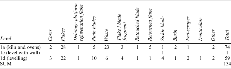
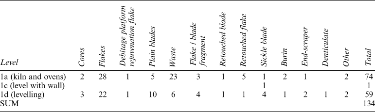
Distribution of lithics in LC4 levels.
So far there is nothing to indicate the presence of imported pottery at the site, and the presence of a pottery kiln implies that the Uruk-style LC4 ceramics were locally made.
LC4 Lithics levels excavated in the 2013 season
Lithics were rare, despite the flotation programme and sieving: a total of just 134 pieces were recovered from Levels 1a–d (Table 1). The majority of artefacts comes from the kiln/oven horizon, and all other pieces but one come from the Level 1d levelling deposit. Chert was used as the major raw material, while imported obsidian and coarse material – here tentatively called cherty limestone – were used only marginally. In total only three pieces were made in obsidian (two blades and one flake-blade) – green, light grey and one almost completely clear; five flakes were made in cherty limestone. A large variety of chert was used (grey, green, blueish, brown, burgundy, pink, white, black, etc.), with medium fine to fine grey chert being slightly more common than others. Better quality cherts were used for blades. Five cores were recovered, all but one being flake cores, unidirectional; one of them is a multi-platformed irregular core, rolled, with smoothed ridges. One core is an exhausted flake and flake-blade core, probably initially a blade core, with a change of orientation. Another core is a blade and flake-blade core, with a change of orientation, which was subsequently used as a tool (visible wear). The level of cortication of the assemblage is low: only 3 pieces (including a core) have more than 50% of cortex present, and 83% of all artefacts did not have any cortex preserved, indicating that early stage-production was undertaken elsewhere. Among modified pieces there are retouched flakes (n = 6) and blades (n = 2), end-scrapers (n = 3), sickle blades (n = 6), burins (n = 3), denticulate (n = 1), flake (n = 1), and blade with a notch (n = 1), scraper (n = 1) and chopper (n = 1). Two of the sickle blades have irregularly retouched truncations on one end.
LC4 Botanical Assemblage from the 2013 season
Seven samples from LC4 contexts in 2013 trenches G and F produced low quantities of plant remains, with a total of 52 seeds and seed fragments. Among the crops from this period, fragments of large pulses, such as lentil (Lens culinaris) and grass pea (Lathyrus sativus) dominate in the assemblage (69.23%), followed by fragments of cereal grains (11.53%); with arable weeds (19.23%), and flax (Linum usitatissimum) (7.69%). An unknown proportion of these finds will have originated from Ubaid period levels disturbed by LC4 digging activities. Particularly interesting is the low concentration of plant remains from the two main fire installation features excavated from Level 1a, including a kiln (context 1528) and a truncated hearth or oven (context 312). This can probably be attributed to regular cleaning of fire installations as we see at other Near Eastern sites, where floors and hearths were regularly cleaned and refuse was disposed of in the middens.
Noteworthy is the incidence of flax (7.69%), most likely a multipurpose crop. Its high content in Omega-3 fatty acids would have made it a good additive to food, in addition to a source of fibres. As we know from earlier sites in the Near East (e.g. Tell Halula and Çatalhöyük) textile production was established from the Pre-Pottery Neolithic.
Late Ubaid Period at Gurga Chiya
Excavation and Stratigraphy
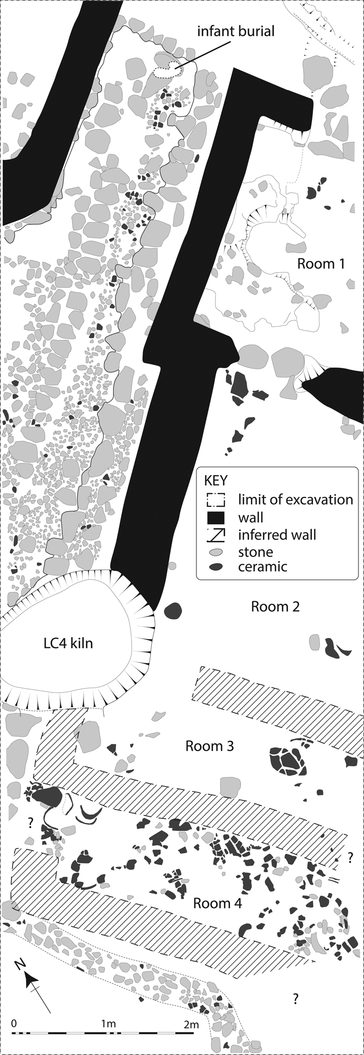
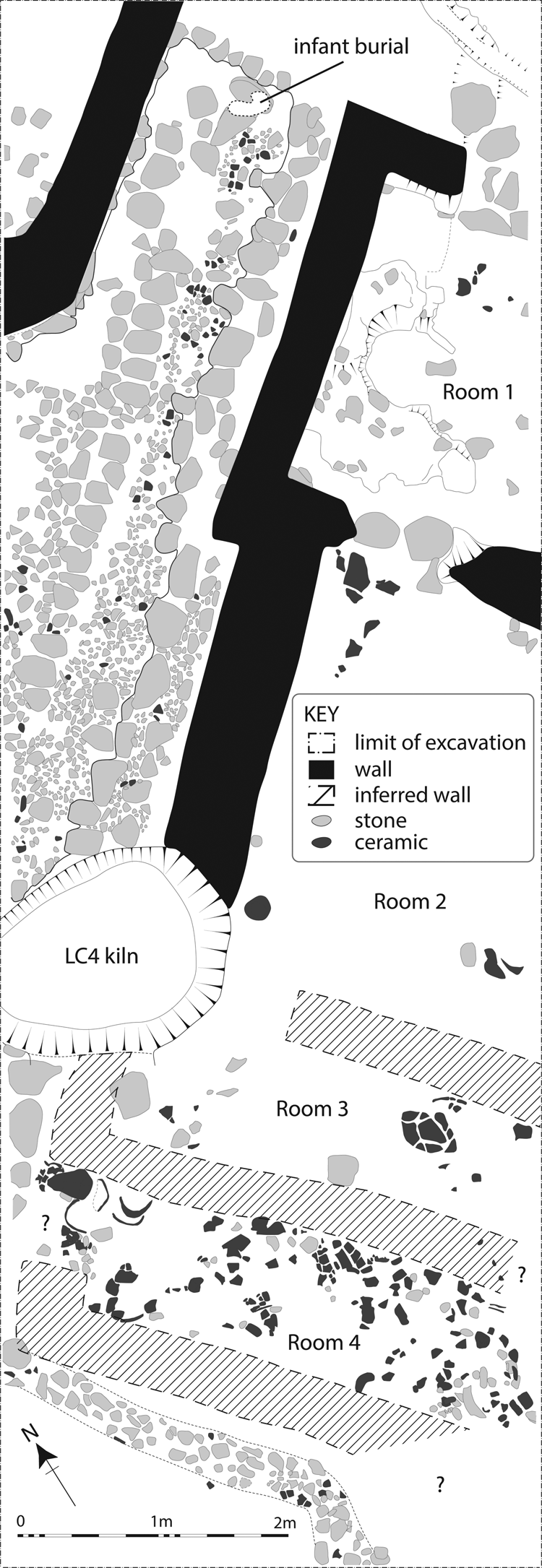
The preceding season's work at Gurga Chiya revealed remains of the Late Ubaid period in Trench E beneath an ephemeral deposit of LC4 material culture (Wengrow et al. Reference Wengrow, Carter, Brereton, Shepperson, Hamarashi, Saber, Bevan, Fuller, Himmelman and Sosnowska2016: 263–265, fig. 11). During 2014, after the trenches were linked, the Ubaid horizon was revealed throughout the combined area. It was particularly well preserved in the upper two-thirds of the trench, and combination with the plans of the lower third excavated in 2013 reveals the partial outline of a burnt building of the Late Ubaid period (Building 1). The building was flanked by a cobbled path, on the other side of which the corner of a further building was found (Fig. 7).
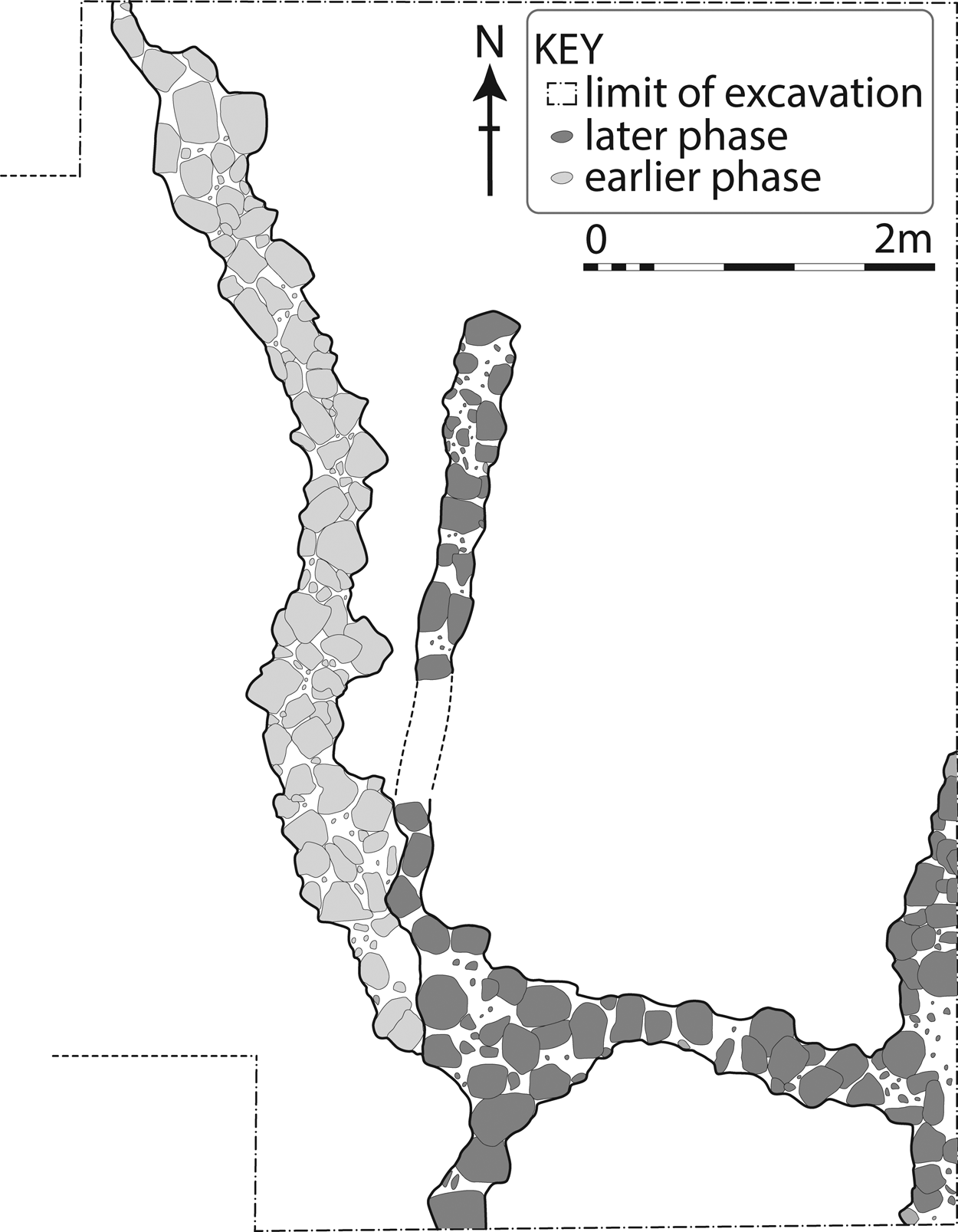
Late Ubaid building and pathway at Gurga Chiya, Level 2. Inferred walling is hatched.
Building 1
Building 1 is constructed of clay or rammed earth walls. Bricks were not detected. The walls were built at least partly on rough stone foundations and form a series of at least four rooms with connecting doorways, running in a linear arrangement alongside the pathway. The walls of the two rooms (3 and 4) to the southwest were not detected during the 2013 excavations of Trench E, but can be reconstructed according to linear distributions of finds. While we are confident of the location of the southwestern wall of Room 3, the position of the southwestern wall of Room 4 remains tentative, and likewise of its doorway facing the cobbled path to the northeast.
A later (post-Ubaid?) installation curved across the northeastern corner of the trench, partially obscuring an entrance passage and doorway into Room 1. A paved surface of large, rough stones stepped downwards into Room 1. The doorway leading into Room 1 was supported by a small rounded buttress, and the threshold between Rooms 1 and 2 was reinforced with stones, one of which was a broken door socket.
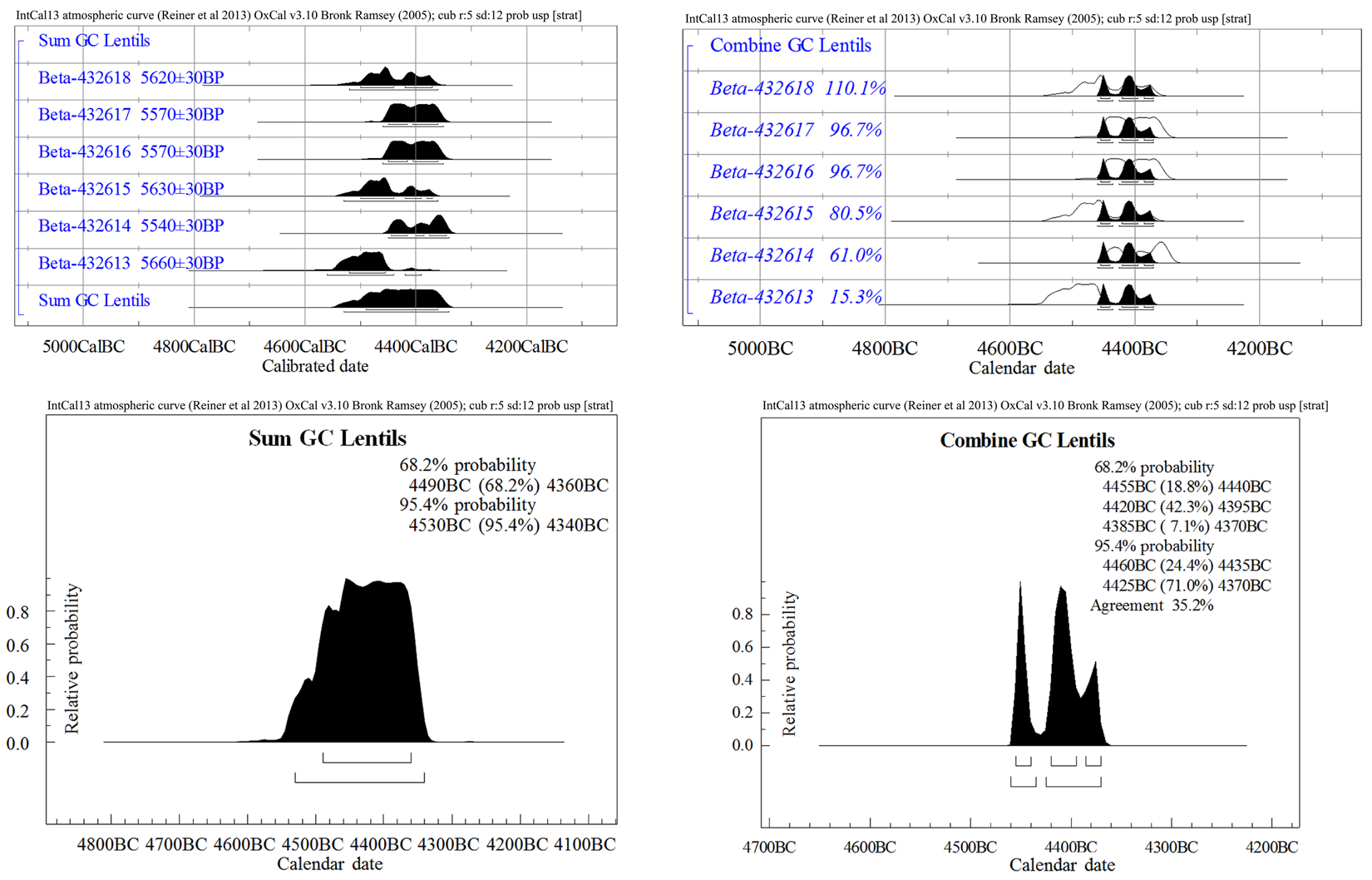
Much of Room 1 was occupied by a large poorly-preserved semi-circular feature, built of small mud-bricks and clay lumps and extensively burnt, most likely the damaged remains of a large storage bin. Its lower fill comprised an ashy deposit around 30cm deep, which was extremely rich in burnt lentils, which had been stored there at the time of destruction. Destruction of this part of the building by fire is further suggested by the presence of burned rubble and pottery fragments in the upper fill of Room 1. Radiocarbon dates from the lentil deposit indicate that the burning event occurred between 4460 and 4370 cal. B.C. (see below).
The northwestern walls of Rooms 1 and 2, although contiguous, are offset by around 20cm, and are of different widths. This is not unusual for domestic architecture of the Late Ubaid period, including houses of the so-called ‘tripartite’ or Mittelsaal type. Alternatively, it could indicate a phase of rebuilding or extension. Excavation of Room 2 halted just above a surface indicated by flat-lying pot sherds from discrete vessels.
The westerly (downslope) continuation of the building extends into the former Trench E and is close to the plough-zone and poorly preserved. Adjacent to Room 2 we reconstruct two further spaces, Rooms 3 and 4, demarcated by clear linear arrangements of artefacts, in particular the dense scatter of crushed Late Ubaid pottery vessels excavated in the 2013 season (Wengrow et al. Reference Wengrow, Carter, Brereton, Shepperson, Hamarashi, Saber, Bevan, Fuller, Himmelman and Sosnowska2016: 265, fig. 11). We consider the gaps where artefacts are absent to represent the position of degraded mud walls. Any entrance between Rooms 3 and 4 remains hypothetical and cannot be detected using artefact distributions; instead we speculate that Room 4 opened directly onto the cobbled pathway.
Cobbled pathway and infant burial
Running between Building 1 and a partly-exposed structure to the north was a pathway constructed in at least two phases (both shown on Fig. 7), the earlier formed of small and closely packed stones in a clay-rich matrix, with a ridge of larger stones running down the middle, perhaps to create drainage down the centre of the alley in wet conditions. This earlier phase slopes towards the walls of Building 1 and the entrance to Room 1, which would have created problems of water accumulation. This most likely prompted the second phase of construction, which involved correcting the slope and adding a raised curb of stones, roughly half a metre wide, which extends along the pathway's southeast side. Both phases of construction would have mitigated the high levels of rainfall encountered in the Shahrizor Plain, which was most likely higher still in the fifth millennium B.C. Cobbled paths are a feature of the region, noted at Qalinj Agha during the LC2 period (Peyronel and Vacca Reference Peyronel and Vacca2015: 97), while the Halaf levels at Arpachiyah displayed several wide “stone roads” (Mallowan and Cruickshank Rose Reference Mallowan and Rose1935: Pl. I: b), and the Late Halaf site adjacent to Gurga Chiya, Tepe Marani, had an area paved with large pot sherds.
The stone path running at a right angle to the cobbled road, along the southwest edge of Building 1, was also built in two phases. The later phase was shown in the previous report (Wengrow et al. Reference Wengrow, Carter, Brereton, Shepperson, Hamarashi, Saber, Bevan, Fuller, Himmelman and Sosnowska2016: fig. 11), and we show the earlier phase here; it appears to make a right angle towards the south. A third and still earlier phase of the pathway and adjacent structures can also be surmised, based on the section of the LC4/Middle Uruk kiln in Trench G, which penetrates below the excavated levels of the Ubaid period.
In the northeastern part of the paved path were found the partially articulated remains of a human infant, less than a year old, apparently laid between the stones of the earlier and later pathways.
Late Ubaid Ceramics from Gurga Chiya
Although a high quantity of residual Ubaid pottery is found in higher phasesFootnote 4, due to extensive disturbance through levelling and pit-digging activities during Level 1, here we will present pottery and statistics from undisturbed Ubaid strata only, Level 2. Statistics are based on a total of 351 Rim Sherds from this phase.
The ceramic assemblage can be characterised as “very Late Ubaid”, which is consistent with a radiocarbon date, calibrating to the third quarter of the 5th millennium B.C. (see below). We have chosen to retain the term “Ubaid” (as opposed to a term such as “pre-LC”) not only because of parallels with earlier Ubaid assemblages, but also because of close affinities with assemblages to the south which have already been designated as Late Ubaid (specifically Tell Madhhur).
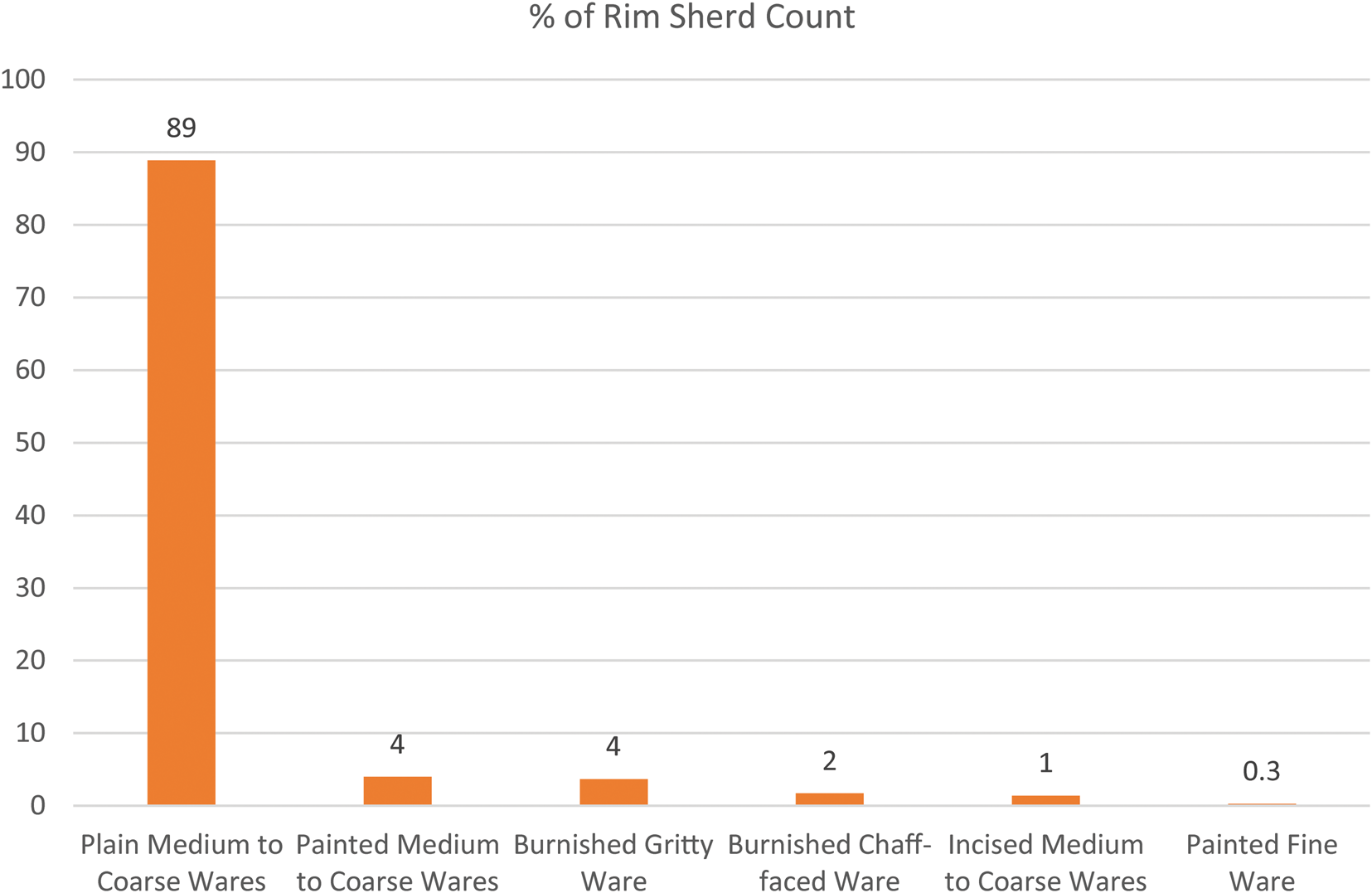
Seventeen Wares were originally defined for the Ubaid assemblage, based on inclusions, coarseness, colour and surface treatment, but their internal consistency and the boundaries between most of them are fuzzy, due to a high degree of variability in firing and quantity of temper; coarseness and colour do not appear to be related to size or surface treatment. The wares were therefore grouped into six classes according to surface treatment and decoration (Fig. 8). Macroscopic examination implies the same clay sources as the preceding Halaf and following LC4 periods, for which petrographic analysis has established a local origin (Himmelman Reference Himmelman2014; Lewis Reference Lewis2017). This may be supported by the presence of what appear to be pot wasters and highly fired clay chunks, possibly kiln lining, scattered throughout the collapsed Ubaid period building, although such material may have derived from house walls and roofing during the intense conflagration that destroyed the building.
Percentages of Late Ubaid ware groupings at Gurga Chiya, Level 2.
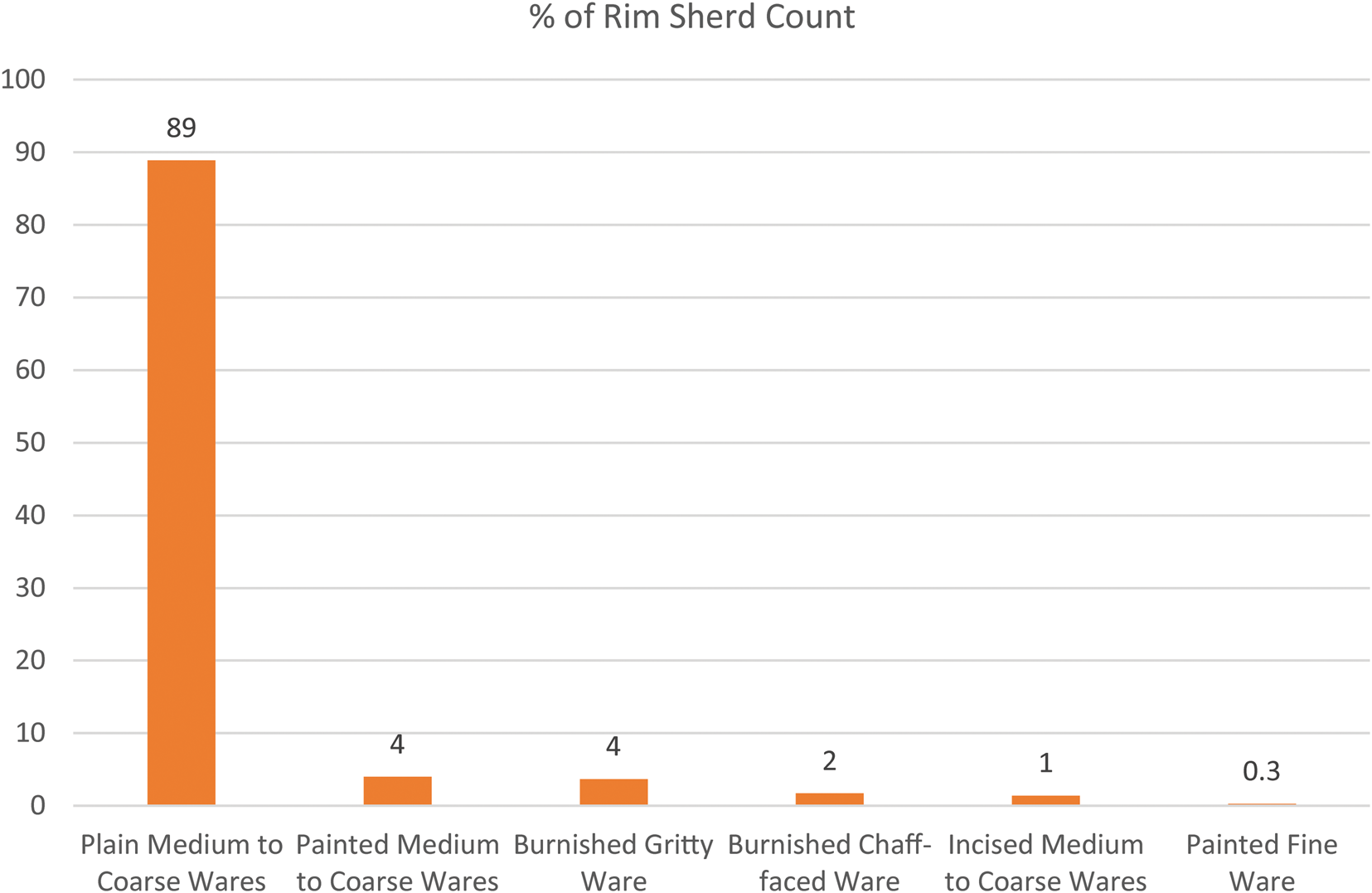
Fig. 8 shows that the vast majority of rim sherds do not bear paint, although the original quantity of painted vessels would have been higher, as the surfaces of the soft fabrics are often eroded. The total percentage of painted pottery (4.3% once Painted Medium-to-Coarse Ware and Painted Fine Ware are added together) is less than the figure given in the previous preliminary report (6.1% by rim sherd count), following additions to the Level 2 assemblage, and it is expected that the final total will differ again once excavation is complete.
Burnished ware includes a chaff-faced brown variety (2%), mainly comprising large trays (cf. Wengrow et al. Reference Wengrow, Carter, Brereton, Shepperson, Hamarashi, Saber, Bevan, Fuller, Himmelman and Sosnowska2016: fig. 12: 21–23) but also shallow bowls and beakers. A Burnished Gritty ware variety (4%), apparently tempered with crushed calcite, is overwhelmingly represented by angle-necked globular jars, interpreted as cooking pots (see e.g., Wengrow et al. Reference Wengrow, Carter, Brereton, Shepperson, Hamarashi, Saber, Bevan, Fuller, Himmelman and Sosnowska2016: fig. 12: 5).
Incised Ubaid pottery is present (e.g., Wengrow et al. Reference Wengrow, Carter, Brereton, Shepperson, Hamarashi, Saber, Bevan, Fuller, Himmelman and Sosnowska2016: fig. 12: 1–2) but statistically rare, and likewise Incised-and-Painted Ubaid Ware, which is not yet represented by any rims and so is absent from the statistics presented above. The same is true for rare examples of impressed Dalma Ware and residual Halaf pottery. Body sherds of Incised and Painted Ubaid Ware and Dalma ware are presented below. Incised Late Ubaid pottery is also found nearby at Tanjero (Saber et al. Reference Saber, Salman, Rasheed and Mühl2014: fig. 7: 1), as well as at Madhhur and other sites (see Wengrow et al. Reference Wengrow, Carter, Brereton, Shepperson, Hamarashi, Saber, Bevan, Fuller, Himmelman and Sosnowska2016 for references).
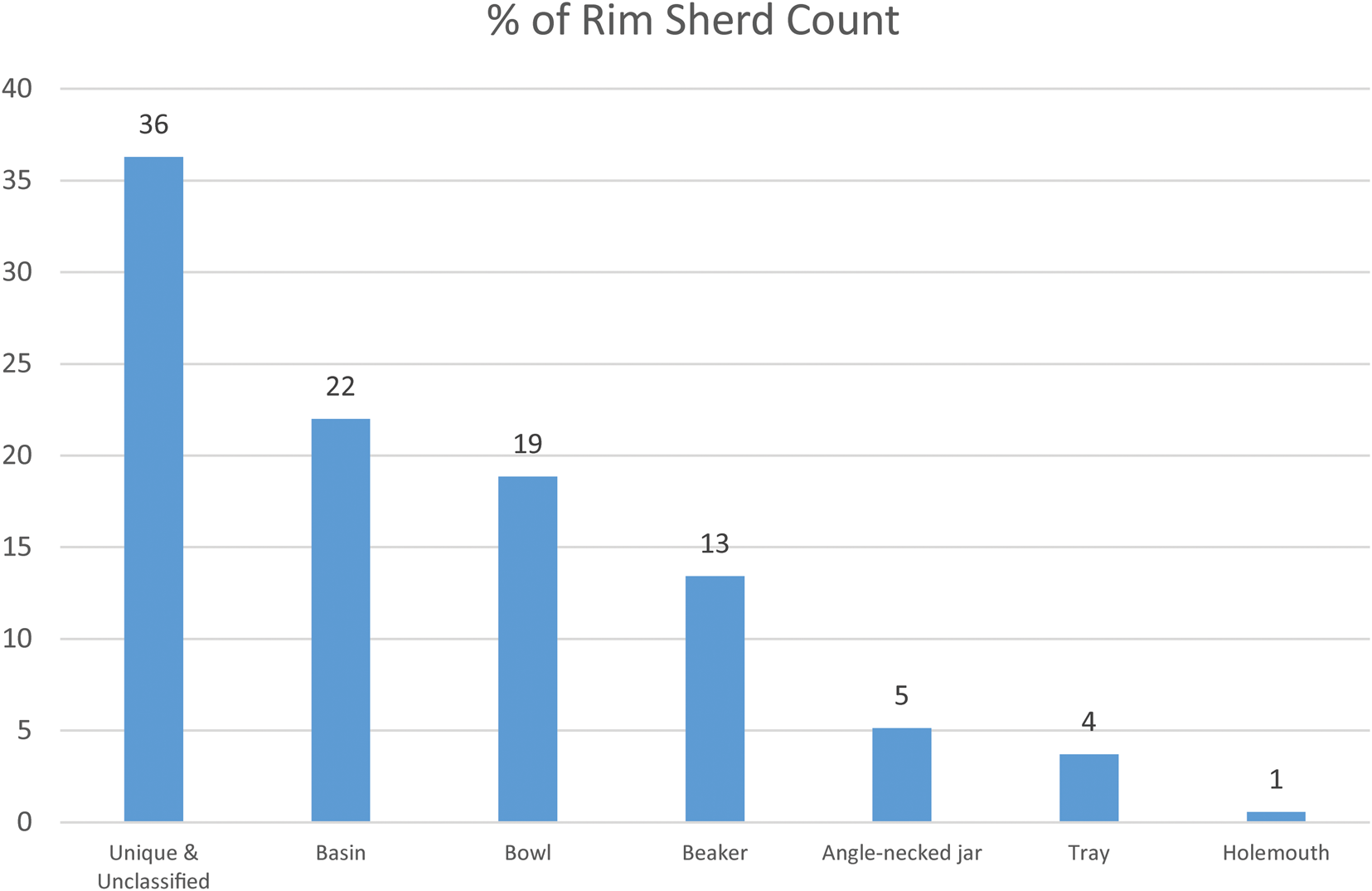
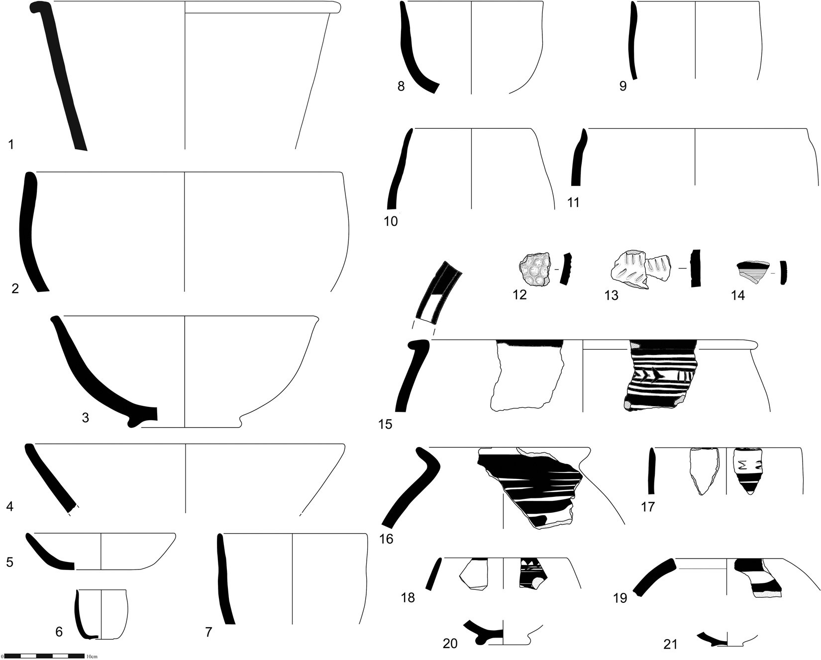
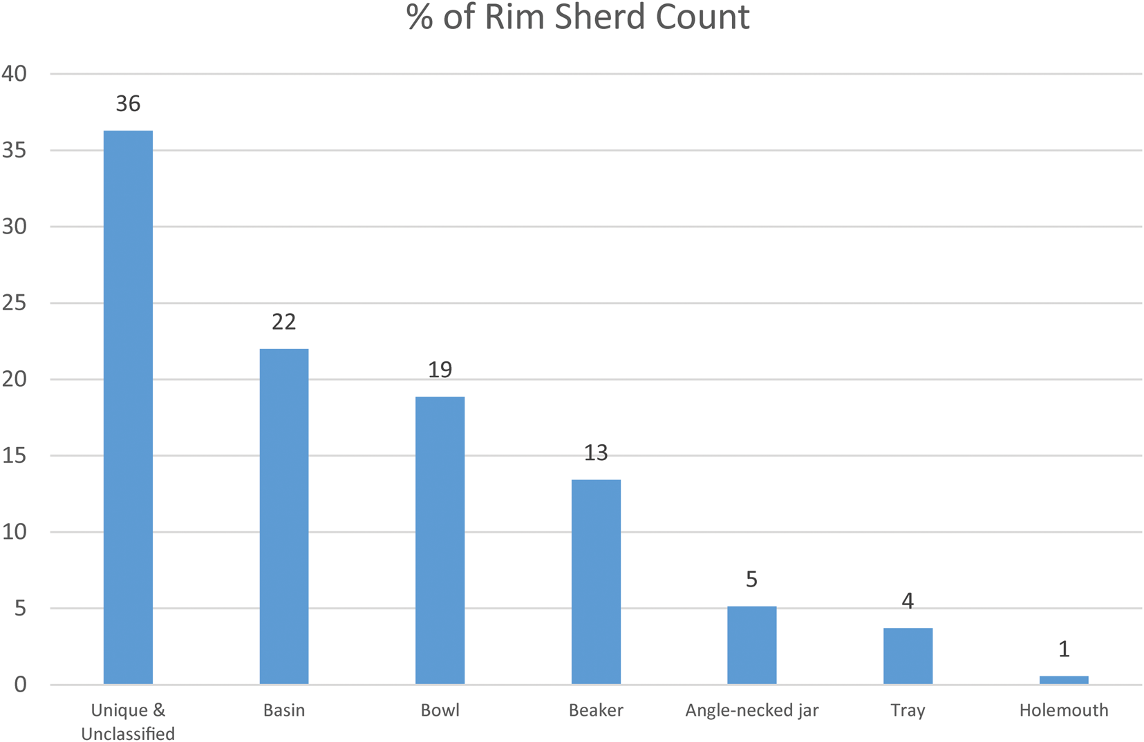
Regarding forms (Fig. 9), the commonest shape is a kind of deep basin with a horizontally extended rim (Fig. 10: 1) (22% of the current Level 2 assemblage). This mainly consists of straight-sided vessels but also includes a barrel shaped variety which is sometimes painted at and below the rim (Fig. 10: 15). Varieties of open bowls combine to contribute 19% (of which 13% are large, diameter 25cm or greater), some with simple rounded rims and curved bodies (Fig. 10: 2, 3), and some with flattened tops and straight sides (Fig. 10: 4). Deep bowls or beakers (Fig. 10: 6–11, 17, 18), mostly medium-sized but with a few smaller examples, make up 13%. Angle-necked globular jars, mainly cooking pots in Burnished Gritty Ware, but also plain and painted examples in chaff-tempered medium and fine wares, account for 5% of the current assemblage, while large trays provide % (Wengrow et al. Reference Wengrow, Carter, Brereton, Shepperson, Hamarashi, Saber, Bevan, Fuller, Himmelman and Sosnowska2016: fig. 12: 20–22). Wide shallow bowls and holemouth globular jars, some with painted decoration (Fig. 10: 19), make up small percentages, and the remainder consists of unclassified or unique types and small rim fragments that could not be reliably typologized. Note that all these figures are likely to change as excavation progresses in future seasons.
Percentages of Late Ubaid forms at Gurga Chiya, Level 2.
Late Ubaid pottery from Gurga Chiya, Level 2. All Medium to Coarse Wares (Plain, Painted and Incised) except no. 12 (Dalma Impressed ware) and no. 14 (Incised and Painted).
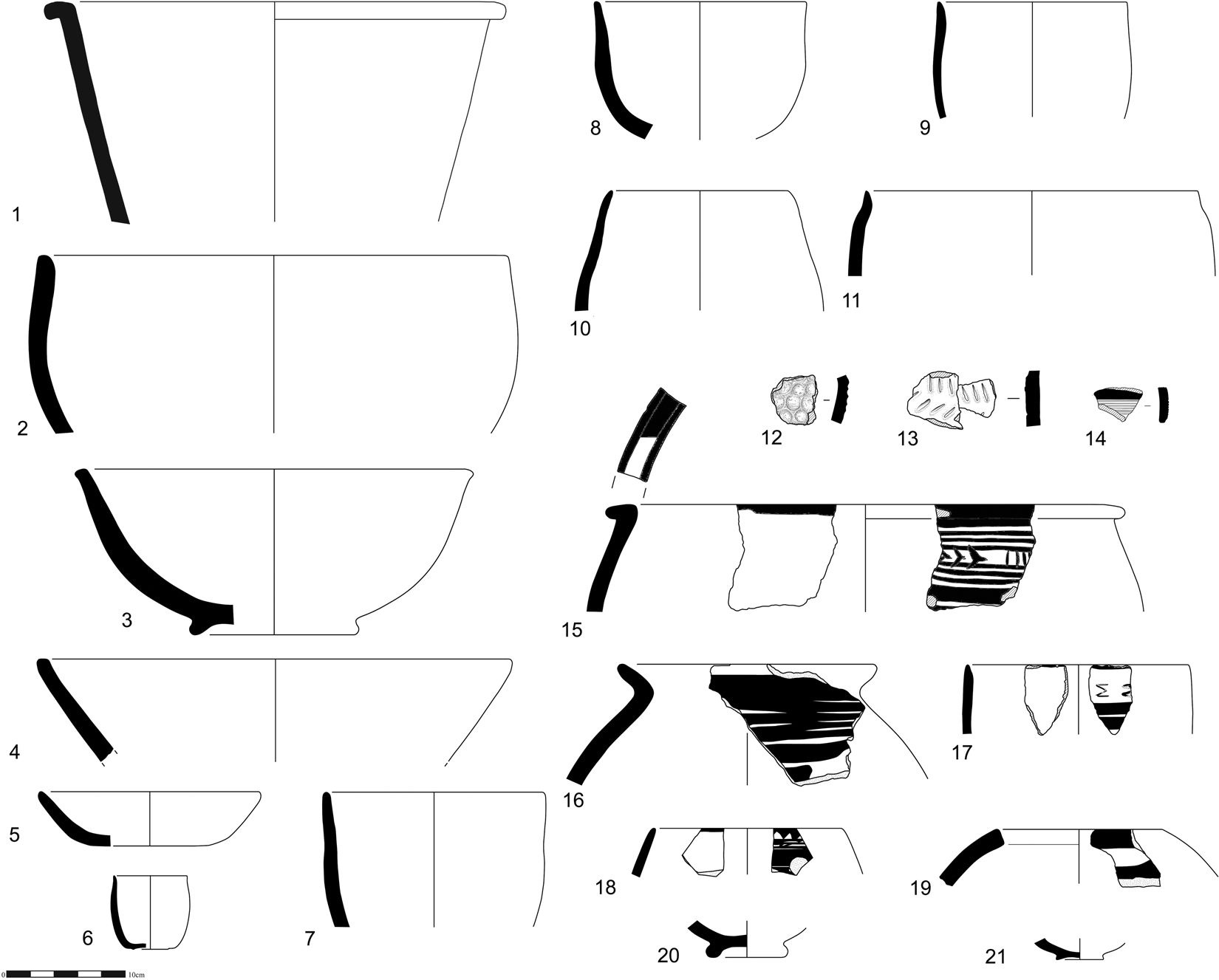
Formal and decorative parallels are best for the Late Ubaid assemblage at Tell Madhhur in the Hamrin, and comparatively poor elsewhere. Particular attention may be drawn at Madhhur to a painted barrel-shaped jar with line and chevron decoration and an extended rim, comparable to Fig. 10: 15 (Moon and Roaf Reference Moon and Roaf1984: fig. 21: 14). The deep basins (Fig. 10: 1) also have excellent matches (Moon and Roaf Reference Moon and Roaf1984: fig. 17). A large bowl with a ring base (Fig. 10: 3) compares to a near identical undecorated bowl from Madhhur (Moon and Roaf Reference Moon and Roaf1984: fig. 16: 5), and many other plain bowls and beakers from Gurga Chiya have matches at the same site, as well as the angle-necked jars (Moon and Roaf Reference Moon and Roaf1984: figs. 16 and 18 respectively). Likewise, the incised wares have good parallels at Madhhur (as noted in the previous report), as well as in the Late Ubaid graves at Tell Abu Husaini (Chiocchetti Reference Chiocchetti2007: fig. 2: d). Also in the Hamrin, the site of Kheit Qasim provides a parallel for the angle-necked jar with horizontal band decoration (Fig. 10: 16, cf. Jasim Reference Jasim1985: pt. ii fig. 264: 3). As reported previously, there is a notable absence of LC1–2 type fossils, such as double-rim jars, double mouthed jars and Sprig Ware (Wengrow et al. Reference Wengrow, Carter, Brereton, Shepperson, Hamarashi, Saber, Bevan, Fuller, Himmelman and Sosnowska2016: 268). Earlier Ubaid sites in the Hamrin, including Tell Abada and the Ubaid 3 site of Tell Hassan, do not provide such good parallels, though Abada is notable for the presence of Incised and Painted ware (Jasim Reference Jasim1985: fig. 215, cf. Fig. 10: 14). For example, Tell Hassan is particularly rich in open painted bowls with flaring rims, which are rare at Gurga Chiya (Chiocchetti Reference Chiocchetti2014: cat. 9–52).
Other sites located further north with Late Ubaid assemblages, including Tepe Gawra and Arpachiyah, provide broadly similar ceramic assemblages but without such close parallels. The same level of (dis)similarity is seen at Helawa, on the Erbil Plain just 9km west of Surezha (Peyronel and Vacca Reference Peyronel and Vacca2015). These Northern Ubaid sites have a significantly richer range of painted bowls and beakers with horizontal and wavy line decoration below the rim, wide bowls with broad line decoration, and painted globular and carinated jars, including those with a perforated internal horizontal ledge (or “channelled rim”, Peyronel and Vacca Reference Peyronel and Vacca2015: 107). Likewise, good parallels are absent from southern sites, including Tell Uqair, the nearest major Late Ubaid site south of Madhhur, although some of the beakers with vertical or inward sloping sides are similar in form to examples from Gurga Chiya (e.g., Lloyd and Safar Reference Lloyd and Safar1943: Pl. XIX: 3–22). These differences are probably partly chronological: the assemblage at Gurga Chiya is likely to be slightly later than the better known northern and southern Late Ubaid/Ubaid 4 assemblages, according to both the characteristics of the assemblage and the radiocarbon dates, which calibrate to 4530–4340 cal. B.C. at 95.4% probability (see below). We also consider that the close parallels with the Hamrin sites and absences elsewhere are due to strong regionalization at this very late stage of the Ubaid period (cf. Baldi Reference Baldi and Iamoni2016a).
Late Ubaid Lithics from Gurga Chiya
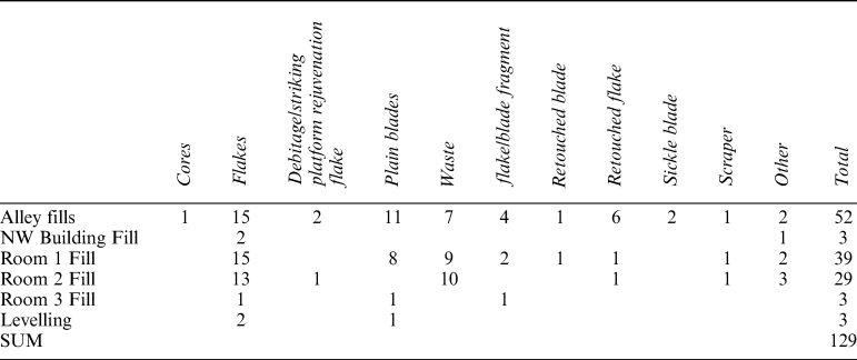
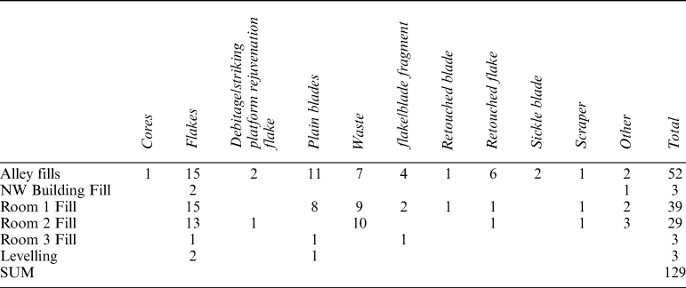
129 artefacts were found in Level 2 deposits (Table 2). The small number of artefacts is in line with other sides from the period, suggesting a significant change in stone tool use (e.g., Hole and Tonoike Reference Hole and Tonoike2016) compared to the Neolithic. In total seven pieces were made of obsidian (three blades, three flakes and one side-blow flake/blade core), all green but one piece which was made of an unusual grey piece with tissue-like pattern. They were found in Room 1, Room 2, the northwestern building and in the alley fills. Eight pieces (mostly flakes) were made on coarse cherty limestone. Like the LC4 assemblage, a wide variety of chert was used. The overall assemblage is slightly more dominated by flakes than blades. Most pieces did not have any cortex present (81% of all artefacts) and only nine had more than 50% cortex preserved, including one with more than 90%. 21 modified pieces were identified, such as sickle blades (n = 2), retouched blades (n = 2) and flakes (n = 8), retouched pebble (n = 1), scrapers (n = 3), straight (n = 1) and obliquely truncated blades (n = 1), blade (n = 1) and flake (n = 1) with a notch, flake with a burin scar (n = 1), side-blow flake/blade on chert (n = 1), and side-blow flake/blade core on obsidian (n = 1). Side-blow flake/blades generally appear to be chronologically restricted to the Neolithic, especially the sixth millennium B.C. (Nishiaki Reference Nishiaki1993), thus making its presence unusual. The only other occurrence of the side-blow flake/blade method in the Chalcolithic was reported from Kenan Tepe (Healey Reference Healey2006). One of the sickle blades (in two pieces) bears exceptionally heavy traces of bitumen. Only one core was found – a flake core on rounded cortical nodule, with flake removals on both sides of the nodule, struck from the same striking platform.
Distribution of lithics in Level 2.
Late Ubaid Botanical assemblage from Gurga Chiya
The Ubaid period archaeobotanical assemblage from Gurga Chiya revealed a high representation of staple crops, mainly pulses and cereals. The frequency and ubiquity of botanical remains decreases rapidly from the Ubaid to Uruk periods. From the 2014 season, 12 flotation samples from storage and fire installation contexts in trenches F and G were analysed, producing 26,528 seeds and seed fragments. Chaff is almost absent from the archaeobotanical record at Gurga Chiya. Only two emmer (Triticum cf. dicoccum) glume bases were recovered, for instance, as opposed to 2,459 cereal grains and grain fragments.
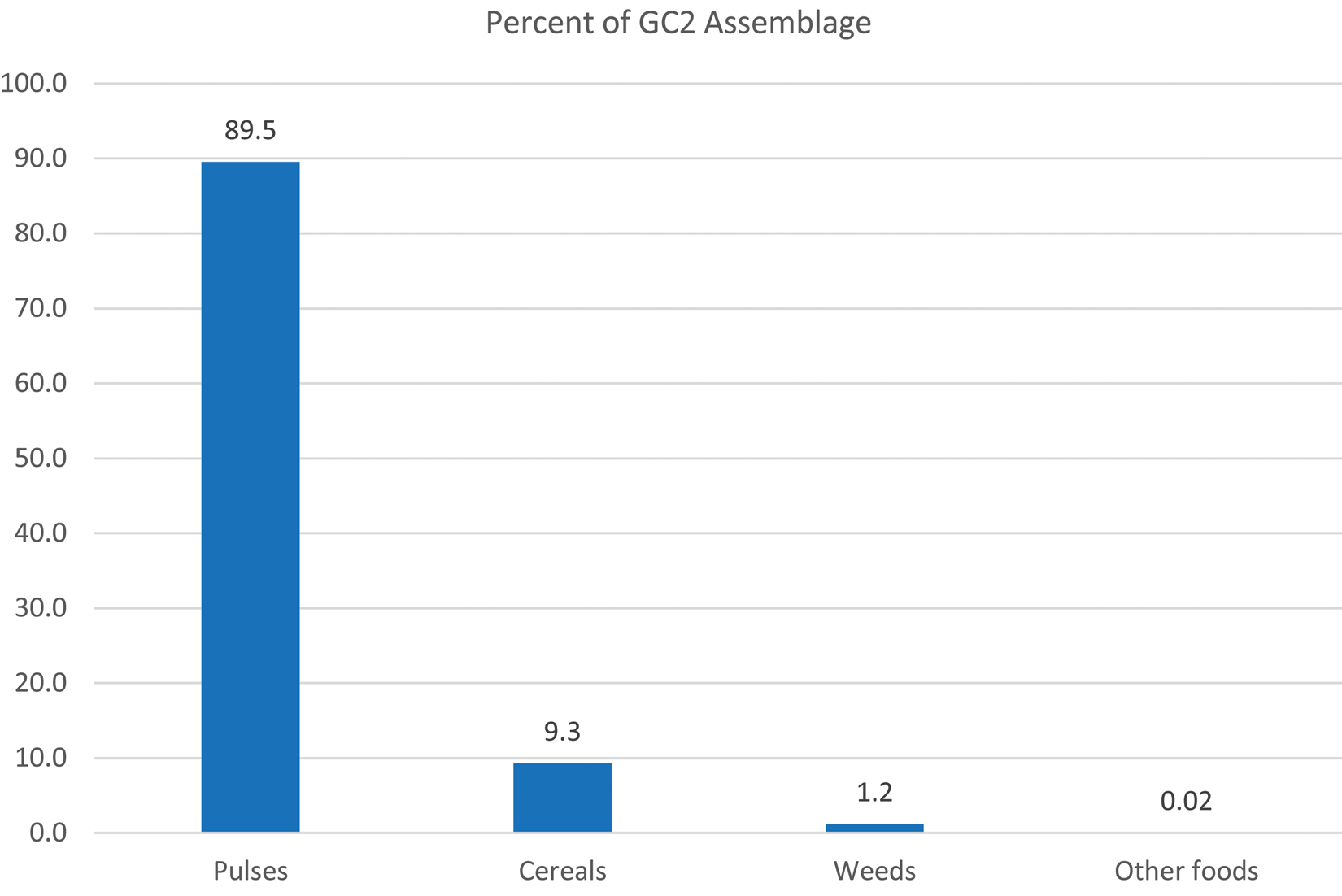
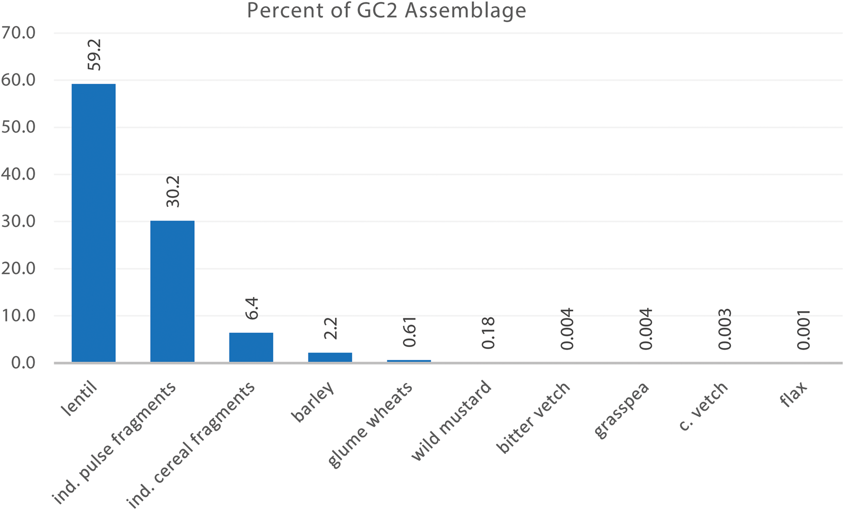
The five flotation samples studied from the Ubaid period yielded a rich botanical assemblage, derived mainly from the storage feature in side Room 2 (contexts 328 and 334). Of a total 26,424 seeds and seed fragments, pulses represent some 89.57%, cereals 9.27% and weeds 1.14% (Figs. 11, 12). Amongst the pulses there is a majority of remains of whole and fragmented lentils (Lens culinaris), making a total of 15,722 seeds and seed fragments. In addition to remains of lentils, there is also a minor presence of grass pea (Lathyrus sativus), pea (Pisum sativum) and two vetches (Vicia sativa and Vicia ervilia). Among the cereals, the highest frequency (69.4%) corresponds to indeterminate fragmented cereal grains (no visible embryo or recognisable shape); in addition, hulled barley is present in the assemblage in very high proportion (24%), while the presence of wheat is remarkably low (6.6%). Among the wild weeds recovered from Gurga Chiya, arable weeds such as Lolium sp. and Vaccaria Pyramidata dominate. In common with Tepe Marani's assemblage, discussed below, wild mustard (Descurania sophia) seeds were recovered from the earliest levels excavated at the site.
Macrobotanical assemblage from Gurga Chiya, Level 2.
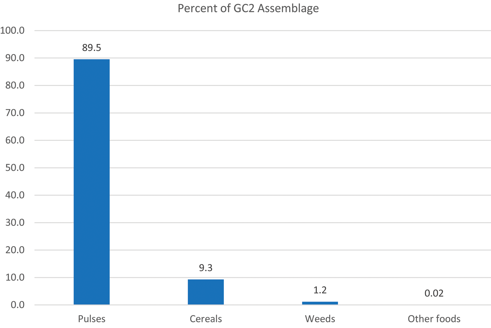
Breakdown of food crops from Gurga Chiya, Level 2.
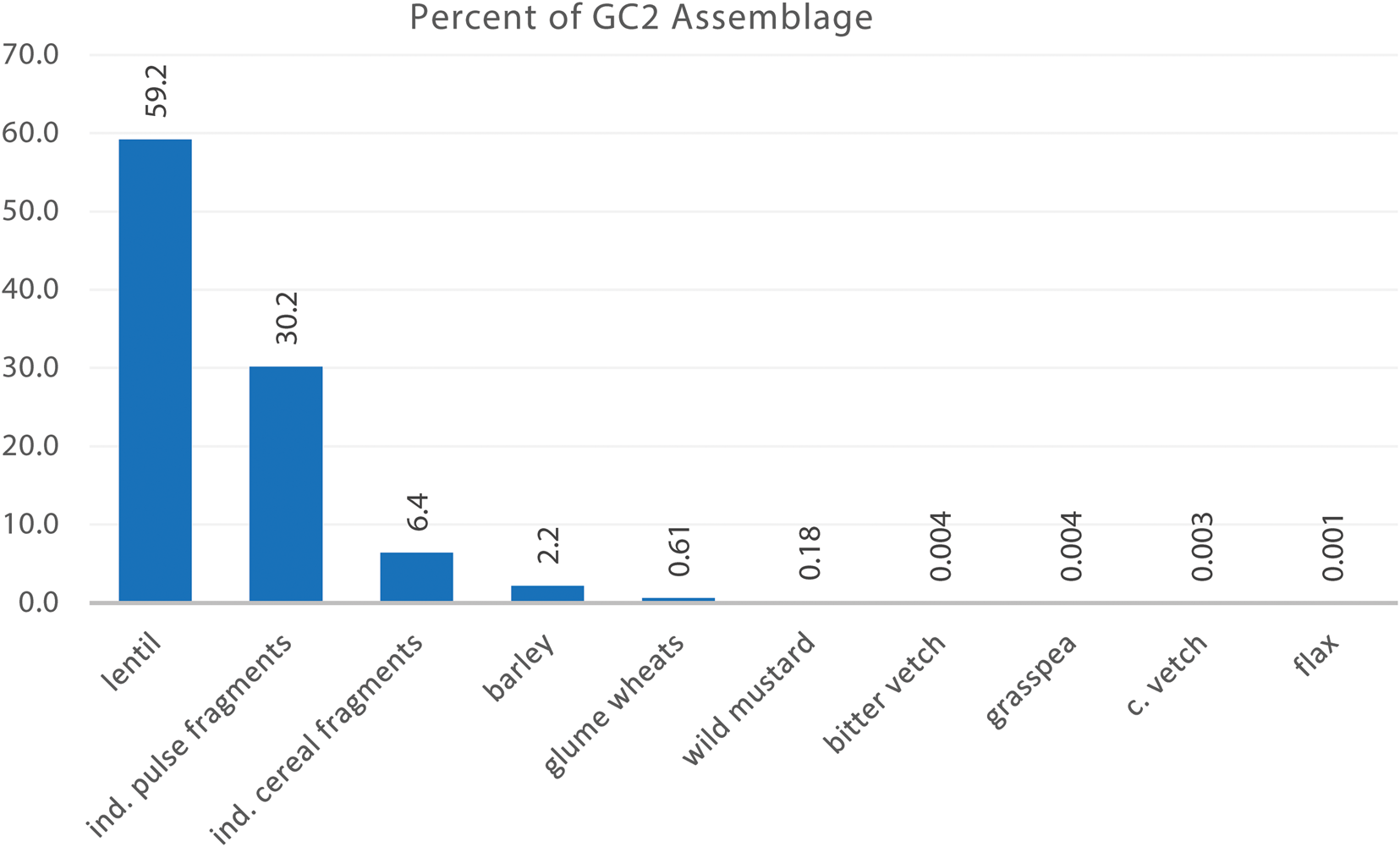
The reported quantities of archaeobotanical remains from Ubaid contexts at Gurga Chiya correspond to assemblages recovered from storage facilities at other Near Eastern sites. Of particular interest is the low presence of cereals in contrast with remains of pulses, which could be attributed to seasonal crop availability or differential culinary uses of plant resources, e.g., wheat used for bread/porridge making. This is largely due to the high absolute quantity of pulse remains resulting from the burning of a lentil storage facility, though we note that lentils were also prominent at Tepe Marani; further excavation of the building and settlement may completely alter the balance of the assemblage.
In addition, a low presence of cereal remains could be partly the result of low chaff in these contexts, which would imply that crop processing activities, such as dehusking, were carried out routinely elsewhere on site, as can be expected in more socially differentiated communities (Fuller and Stevens Reference Fuller, Stevens, Fairbairn and Weiss2009). The low presence of weeds at Gurga Chiya also implies that processing took place outside the building, with only processed grains and pulses stored inside the building. In contrast, at the slightly earlier Ubaid period site of Kenan Tepe in southeast Turkey, the data from roof collapse layers indicate that cereal processing took place on the roof (Graham Reference Graham2011: 190), providing evidence that processing took place within the household but outside and above the enclosed rooms. Future analysis of collapse layers at Gurga Chiya may provide complementary data.
The Ubaid period burnt building at Kenan Tepe (Level 3), located more than 500km away in the upper Tigris region, provides the nearest comparable assemblage in terms of both chronology and geographical proximity (Parker et al. Reference Parker, Foster, Henecke, Hopwood, Hopwood, Creekmore, Demirergi and Eppihimer2008: 104, 106), although we note that the “snapshots” provided by the burnt buildings at both sites (Gurga Chiya and Kenan Tepe) may only provide part of the picture, relating to the activities of single households at a particular time of year. At Kenan Tepe, lentils (at 4%) were less common than cereals, and also less common than flax (5%), although they had a high measure of ubiquity (found in 22.7% of samples) (Graham Reference Graham2011: 133–134). Other legumes, including peas, were also found, as at Gurga Chiya. Wheat comprised nearly two-thirds of the assemblage, mainly emmer (38% of the whole), but barley was also frequent (21%). The proportions of “economic taxa” for all four of Kenan Tepe's Ubaid phases combined are similar (Graham Reference Graham2011: 167, fig. 7.1). These data indicate that legumes were an important part of the Ubaid period diet, in contrast to previous indications (Graham Reference Graham2011: 173), an observation amply supported by the finds at Gurga Chiya. Ubaid period botanical remains from Tell Zeidan, some 600km away in the Balikh region of Syria, likewise show consistent use of lentils and other legumes, with 40% ubiquity in Ubaid period samples (Smith et al. Reference Smith, Graham and Stein2016: 60).
Radiocarbon Dates from Level 2 (Late Ubaid) at Gurga Chiya
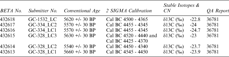
Radiocarbon evaluations were undertaken on five burnt lentils from two contexts in Level 2 (Context 334, the main mass of burnt lentils in Room 1, and Context 328, the context above it), as well as from a higher Level 1 (LC4) layer (Context 1532) (Table 3). The latter is considered likely to have originated from the Level 2 burnt lentil store, along with many other burnt lentils found scattered in the LC4 levels, presumably redistributed by later disturbances. The radiocarbon date confirmed that this was the case.
Radiocarbon dates from Gurga Chiya, Level 2. All samples are AMS-Standard delivery, charred material, pre-treated with Acid/Alkali/Acid.
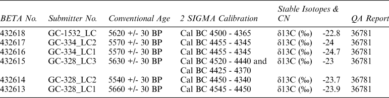
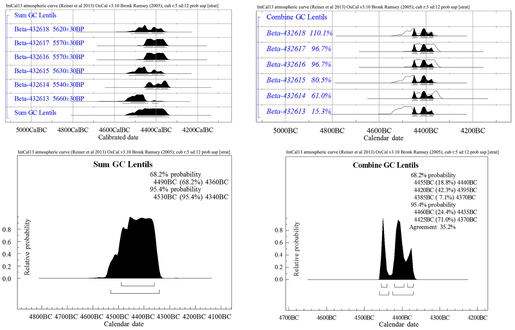
After calibration the Sum Probability offers a range of 4530–4340 B.C. at 95.4% probability (Fig. 13, left hand side). On the assumption that the lentils were of exactly the same age (part of the same crop), then OxCal's Combine function can be used to calculate a tighter range of 4460–4370 B.C. at 95.4% (Fig. 13, right hand side).
Calibration of Radiocarbon Dates from Gurga Chiya, Level 2. Left top and bottom: Individual and Sum Probabilities. Right top and bottom: Combined Probabilities.
The Late Neolithic settlement at Tepe Marani
Excavation and Ceramic Summary
In the previous season, Late Neolithic settlement remains were discovered in two parts of the shallow mound of Tepe Marani. A rough-stone wall footing, curvilinear in plan, had been uncovered in Trench A near the centre of the mound, and its associated fills were radiocarbon dated to the mid-late sixth millennium B.C. A second test trench (B) to the west revealed a dense sequence of midden deposits of similar date, capped by a layer of pottery sherds that had been horizontally laid to create a continuous surface. Both areas warranted further investigation and were expanded in the 2014 season.
The pottery of Tepe Marani can be broadly be characterised as Late Halaf (see Wengrow et al. Reference Wengrow, Carter, Brereton, Shepperson, Hamarashi, Saber, Bevan, Fuller, Himmelman and Sosnowska2016: 272–274, figs. 18–19), but the material from the 2014 season requires further study and will be presented in detail in a future report. Its forms and fine polychrome decoration compare well to recently published material from nearby Tell Begum, which is also assigned to the Late Halaf and perhaps Halaf-Ubaid Transition (Nieuwenhuyse et al. Reference Nieuwenhuyse, Odaka, Kaneda, Mühl, Rasheed and Altaweel2016: 126). Informal examination of the 2014 Tepe Marani material suggests there may be elements of the Halaf-Ubaid Transitional in the upper levels of Trench A, subject to confirmation through further study. In the previous season radiocarbon dates indicated calibrated ranges running from the mid sixth millennium B.C. through to the beginning of the last quarter of the millennium (Wengrow et al. Reference Wengrow, Carter, Brereton, Shepperson, Hamarashi, Saber, Bevan, Fuller, Himmelman and Sosnowska2016: 268).
Tepe Marani Trench A
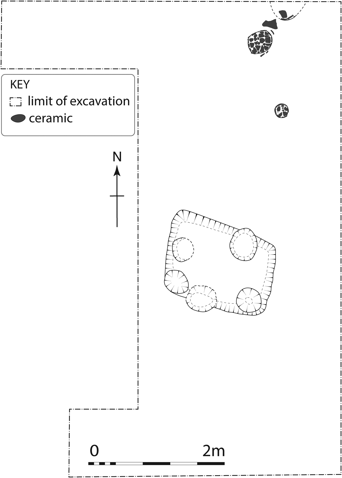
Trench A was extended to clarify the plan of the curvilinear building, initially thought to be a typical Halaf-style tholos structure. As expected, the overlying deposits were highly degraded, and mud-brick or pisé features were not preserved. Careful excavation nevertheless revealed a series of elements post-dating the abandonment of the curvilinear structure, including collapse, abandonment and reuse of the area. These included rubbish pits containing substantial quantities of broken pottery, animal bone, chipped and polished stone tools; remnants of a clay-lined tannur; and the possible remains of a burnt storage facility ringed by post-holes (Fig. 14).
Upper occupation at Tepe Marani, Trench A.
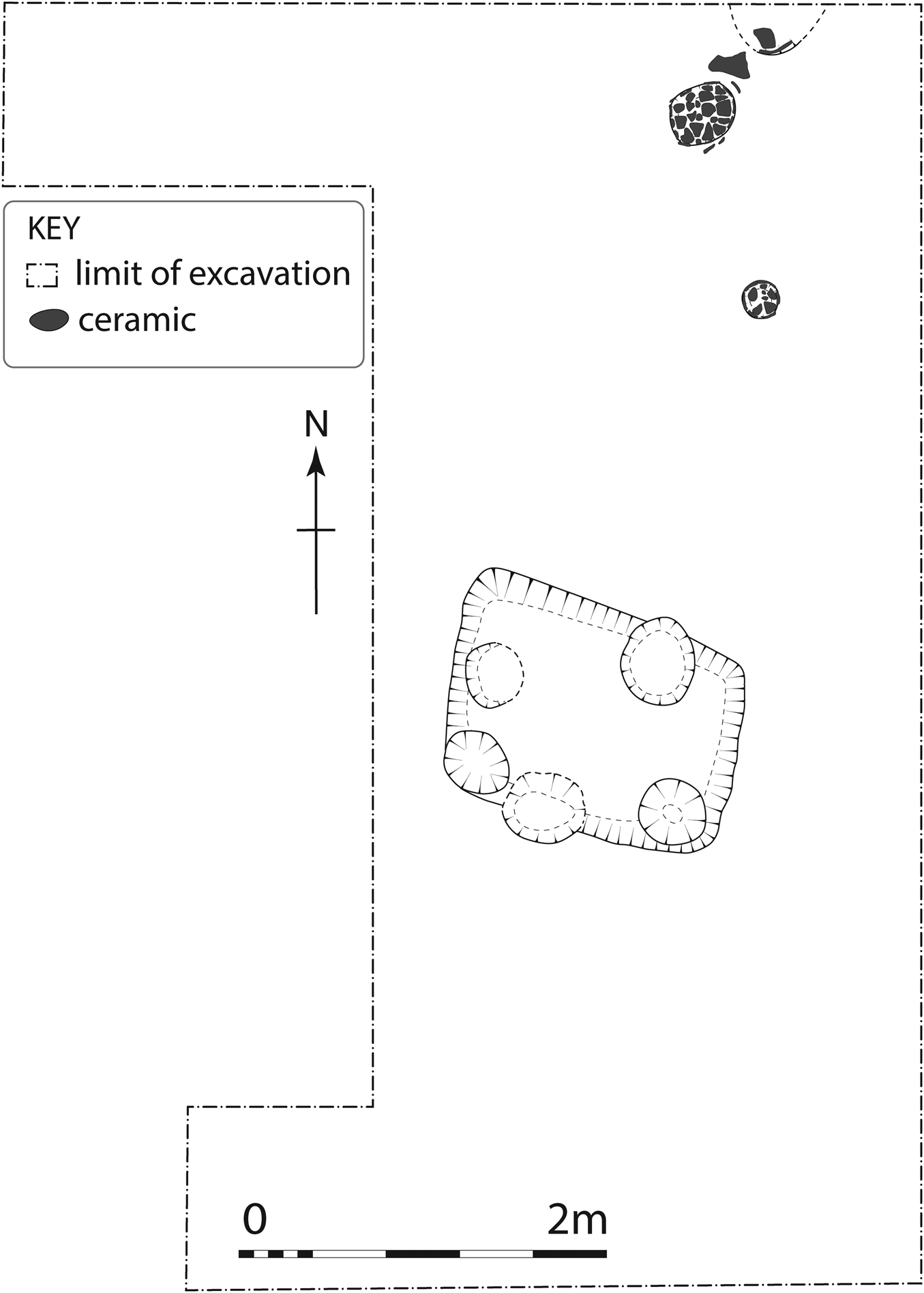
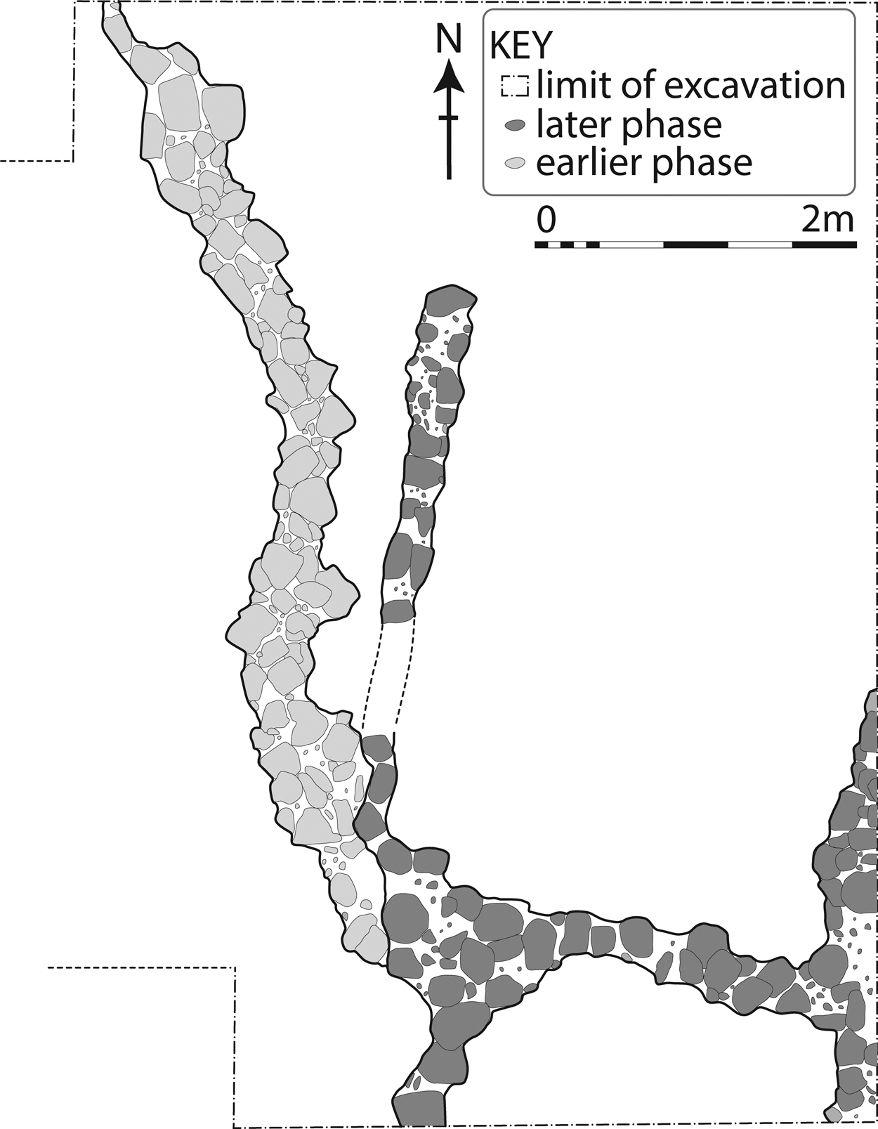
Beneath this phase was a level of collapse and abandonment. This included ashy debris and sealed a phase of roughly built stone rectilinear architecture, probably wall foundations (Fig. 15, later phase). These walls appeared to truncate the curvilinear structure detected in the previous season (Fig. 15, earlier phase), altering its original plan but likely re-using part of its southern wall. This earlier phase was also associated with an ashy destruction or occupation layer. The relationship between the two building phases was obscured by the collapse and tumble of loosely bonded cobble foundations, and an absence of preserved floors makes any further interpretation difficult, but it is no longer possible to posit the existence of a tholos structure.
Wall remains in lower phases of occupation at Tepe Marani, Trench A.
Tepe Marani Trench B
Trench B, on the western side of the mound, was extended to 4m x 4m, with the aim of investigating the midden deposits encountered in 2013. Beneath horizontal layers rich in cultural material, perhaps reworked midden deposits, there was a sequence of large cuts containing multiple dark fills that were rich in organic material and household debris. Evidence of in situ combustion was present in these fills in the form of layers of blackened fill resting above pale grey ashy layers, in turn resting above reddened burnt soil. This implies deliberate rubbish burning in the pits, but micromorphological study (by W. Sagan) also indicated the presence of burnt mudbrick or pisé in the fills. This implies that debris from burnt structures had also been dumped in the pits, potentially connected to the evidence of burning in several levels of Trench A. The micromorphological data will be presented in full in the final publication.
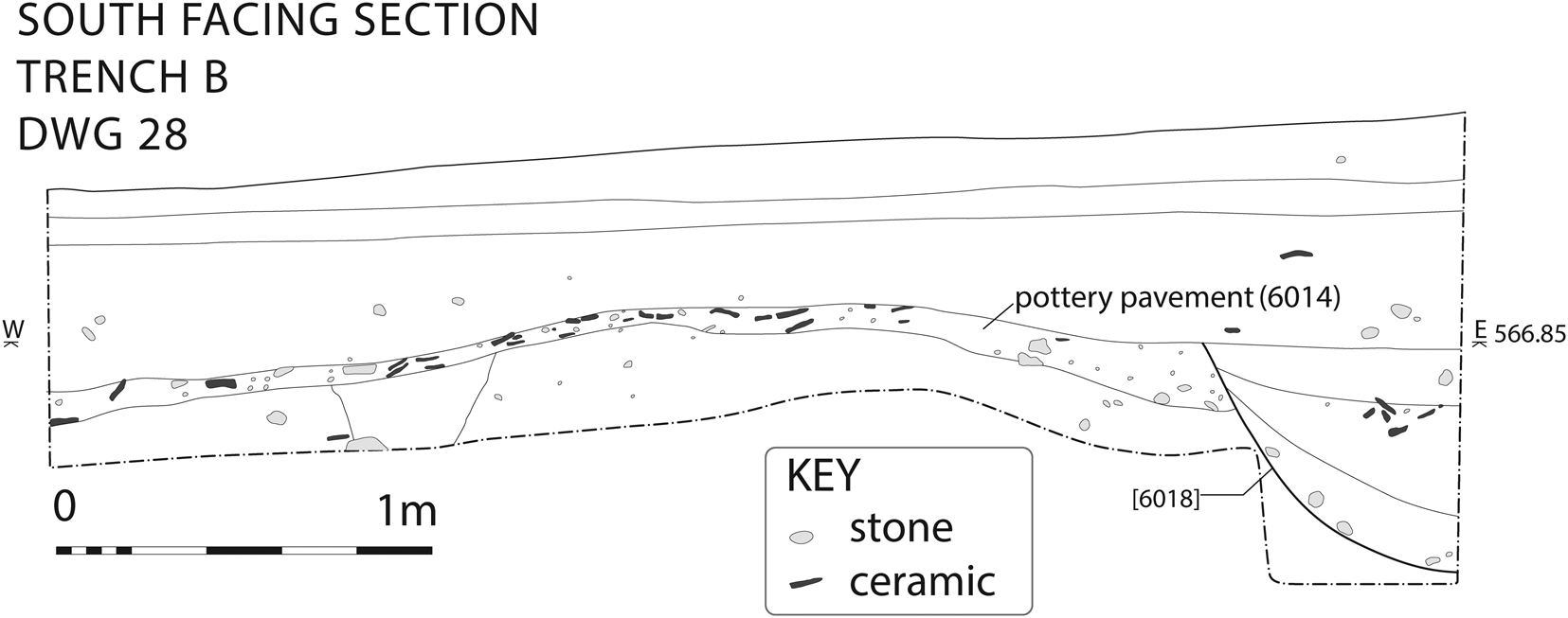
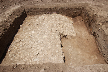
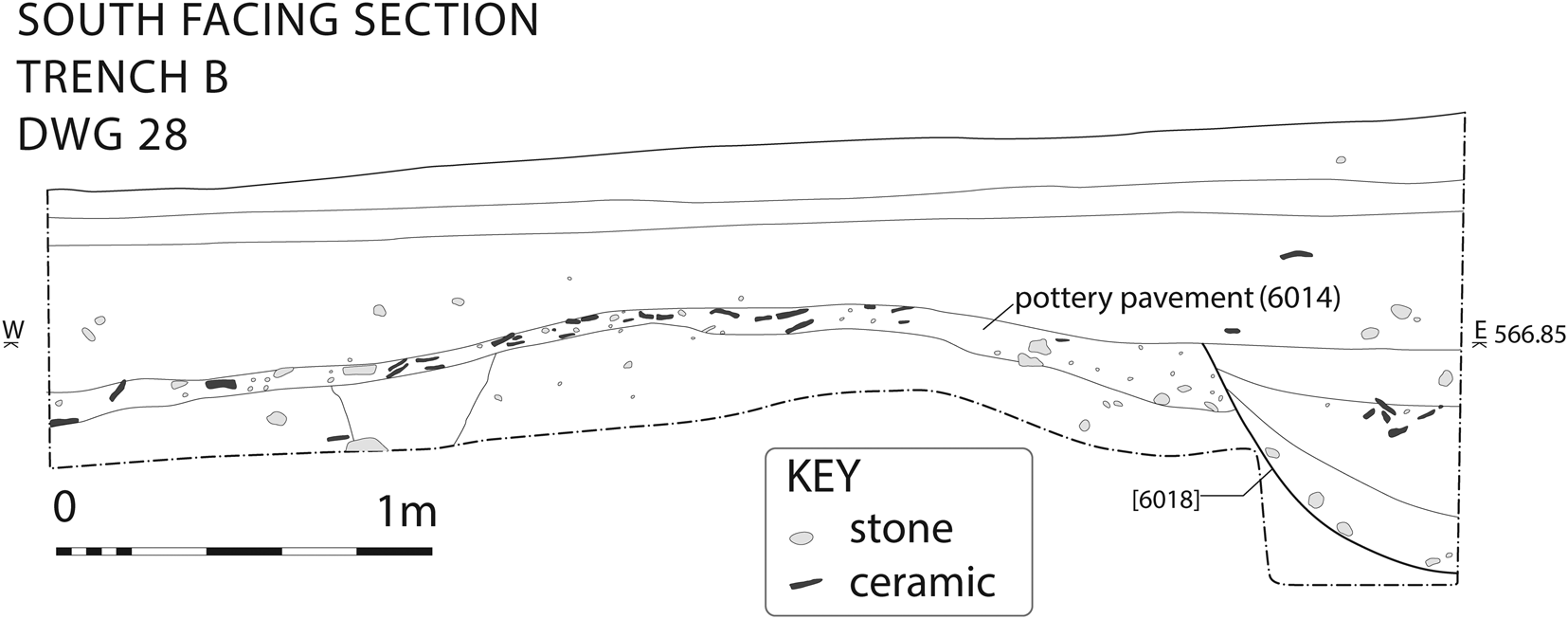
The cuts truncated a continuation of the pottery “pavement” (6014) detected in the previous season (Fig. 16, Fig. 17). The extraordinary density of pottery in this layer, and the horizontal bedding of sherds to a thickness of 10–20 cm, indicate the deliberate creation of a large surface, perhaps intended to facilitate crossing of a marshy area. The layers beneath the pottery pavement were not burnt but still rich in cultural material and may represent earlier midden levels. Within these layers was a narrow linear feature running north-south, most likely a mud wall.
South-facing section at Tepe Marani Trench B.
Pottery paving, Tepe Marani Trench B, looking north. Its truncation along the northeastern edge was caused by an ancient cut, while the square truncation in the southeast marks the test trench removed during the 2013 season.
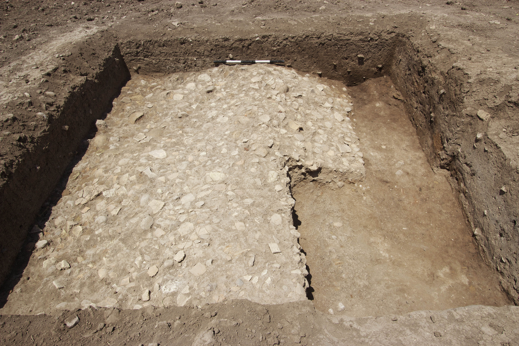
A pronounced break of slope runs from north to south along the pottery pavement, indicating a ditch, watercourse or other steeply dipping feature beneath it on the eastern side. The later cuts and midden tip lines followed the edge of this feature, perhaps indicating maintenance of a ditch or modification of a natural drainage feature.
Tepe Marani Geophysical Survey
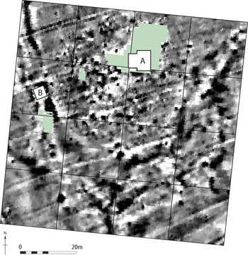
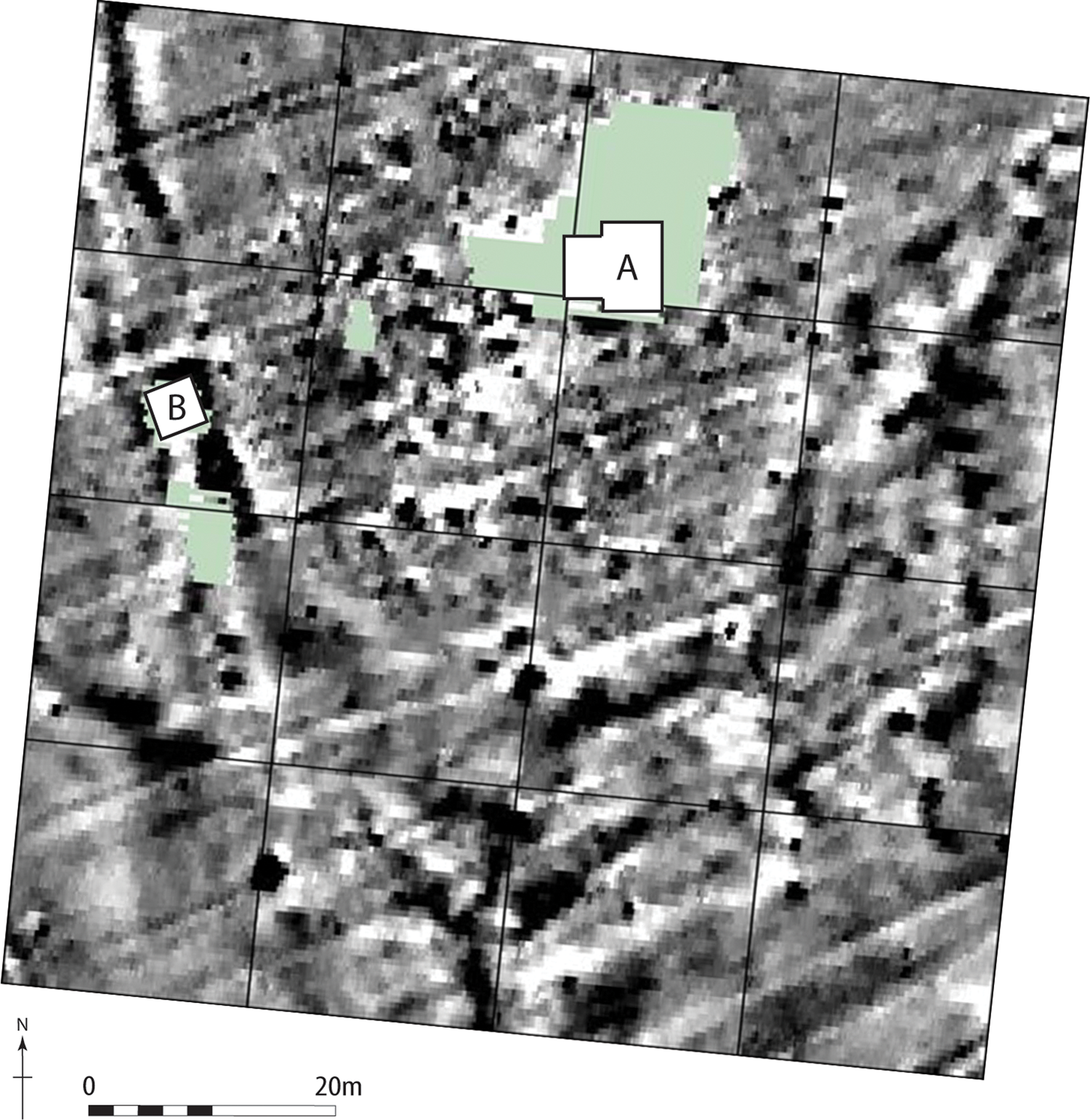
The extent of the ditch or watercourse was clarified through magnetometry survey conducted by Dr Kris Lockyear, using a Bartington Grad-01 Dual Magnetometer. This identified an extensive V-shaped linear feature, perhaps doubled (i.e. with parallel ditches), which ran either side of the main part of the site where Trench A was located and crossed the location of Trench B (Fig. 18). We identify it with the ditch on the eastern side of Trench B. We cannot tell if this feature was originally natural or judge the extent of its modification, but we consider that it would have been a watercourse or marshy ditch which surrounded the site on at least three sides. It may have had a protective function, but it would also have served to drain the central part of the site in wet conditions.
Plot of magnetometry results at Tepe Marani, with location of 2014 Trenches A and B.
Tepe Marani Phytolith Analysis
Phytolith samples from Trenches A and B were examined by Anke Marsh, sampled during the previous 2013 season. While one of the Trench A samples (5003, overlying the stone-built curvilinear feature) showed a prevalence of dicotyledons (trees and bushes), all the Trench B samples showed the presence of wetland plants, namely reeds and sedges. One of the midden fills within the cuts that truncated the pottery paving was sampled (6004), and this contained a more varied assemblage of wild grasses, cereal husks and wetland plants. Full details will be presented in the final report.
Tepe Marani Late Neolithic (Late Halaf) Botanical Assemblage
Nineteen flotation samples were analysed, yielding 549 seeds and seed fragments, the majority from Trench A. A generally low incidence of chaff was noted, in contrast to the high number of pulses and cereal grains and cereal/pulse fragments, which were interpreted as possible waste from food preparation and cooking activities.
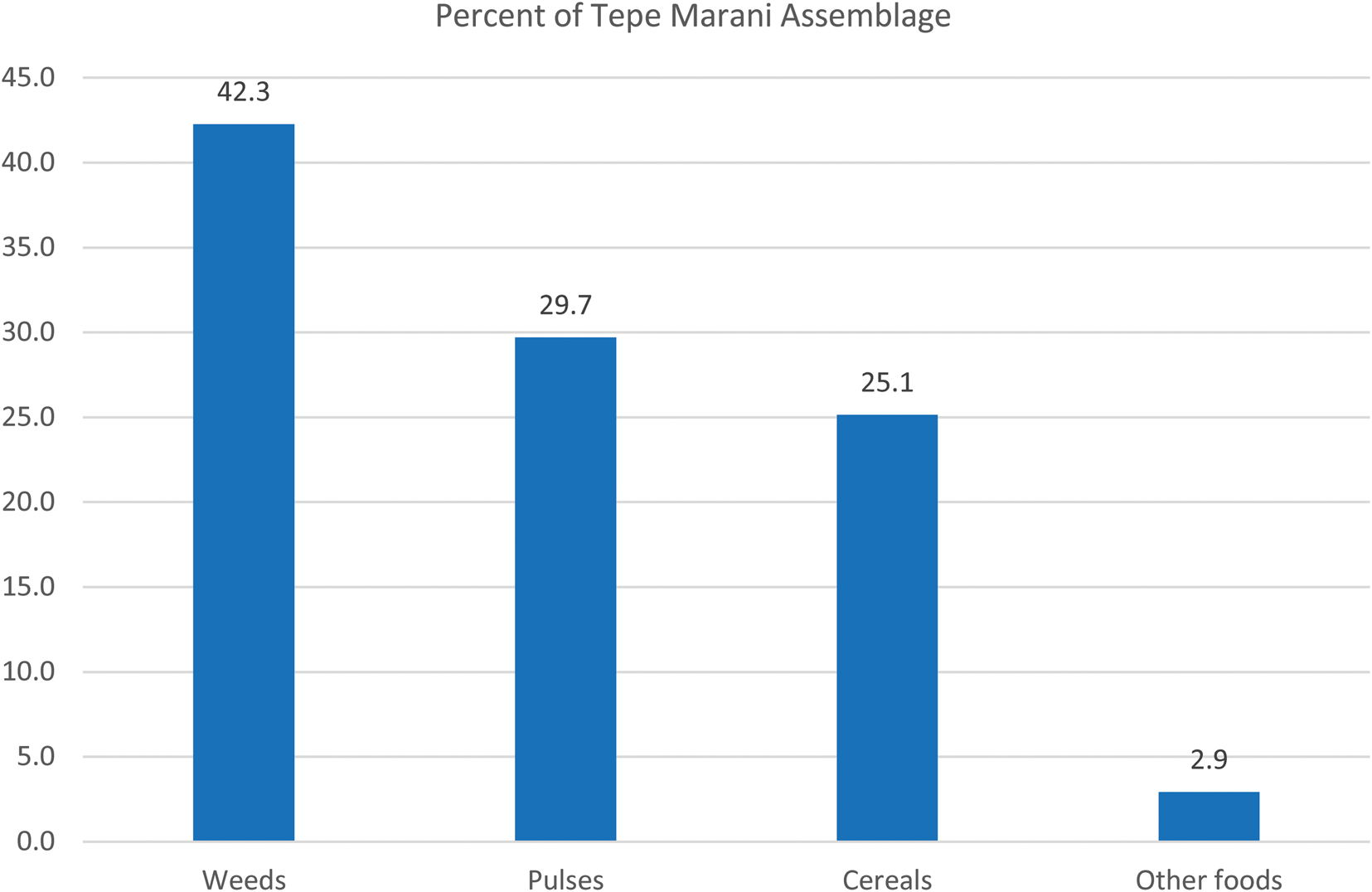
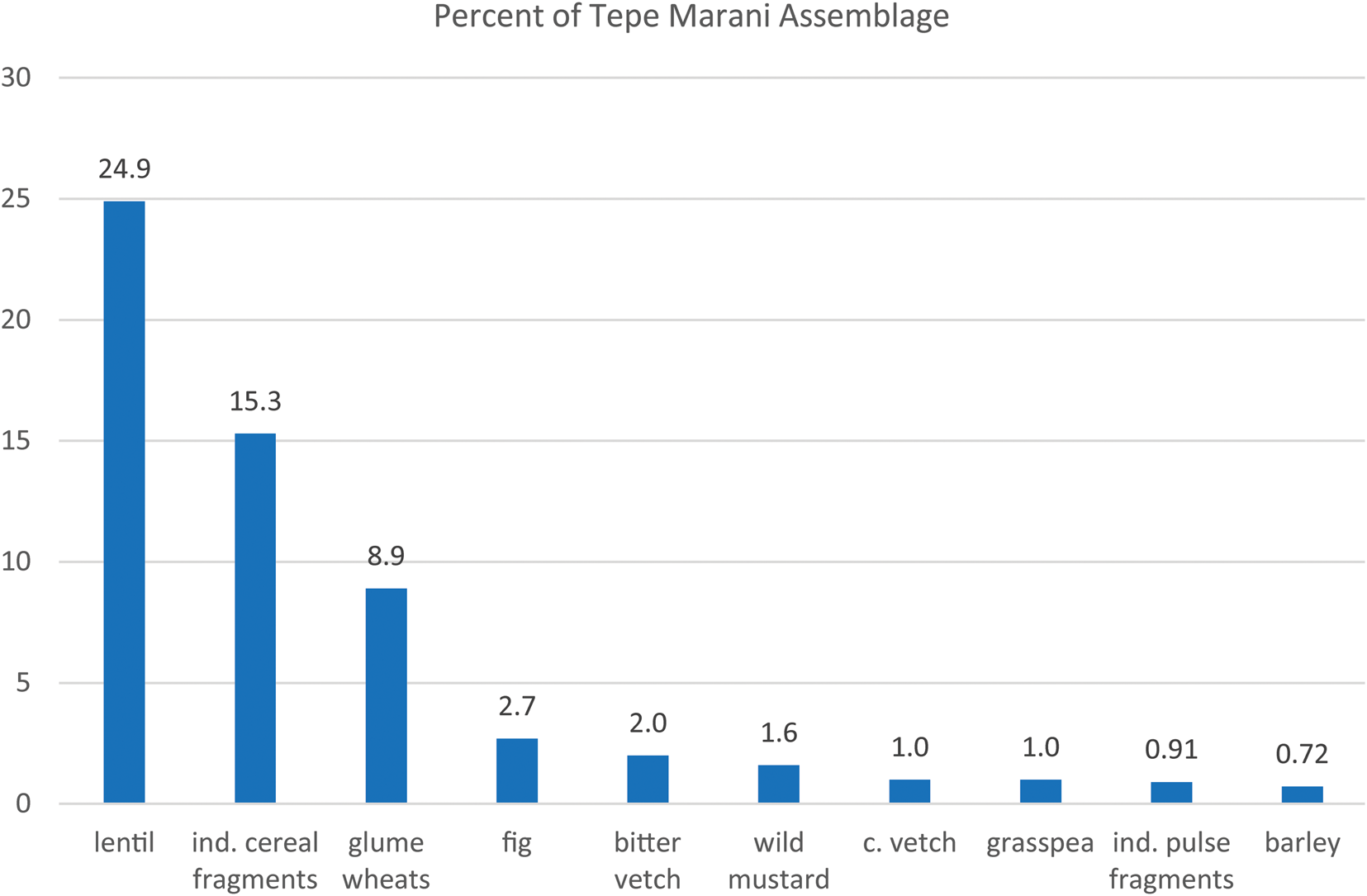
The plant food assemblage as a whole is dominated by pulses (nearly 30%), followed by fragments of cereals (25%), with c. 3% of other foods, in particular fig seeds (Ficus ficaria) (Fig. 19, Fig. 20). The 42% of various species of weed seeds probably derive mostly from arable weeds. Although pulses are most frequently recovered, cereals have the highest ubiquity, being present in 79% of the samples. They include a preponderance of fragments of emmer wheat grains (Triticum cf. dicoccum) and “new type” glume wheat grains (Triticum cf. timopheevi). Barley is present in very low proportion relative to wheat, with just two symmetrical grains of hulled barley (Hordeum vulgare L.) and two barley rachises recovered. Among the pulses, lentil (Lens culinaris) dominates the assemblage, being present in 47% of the samples with a total of 137 seeds and seed fragments.
Macrobotanical assemblage from Tepe Marani.
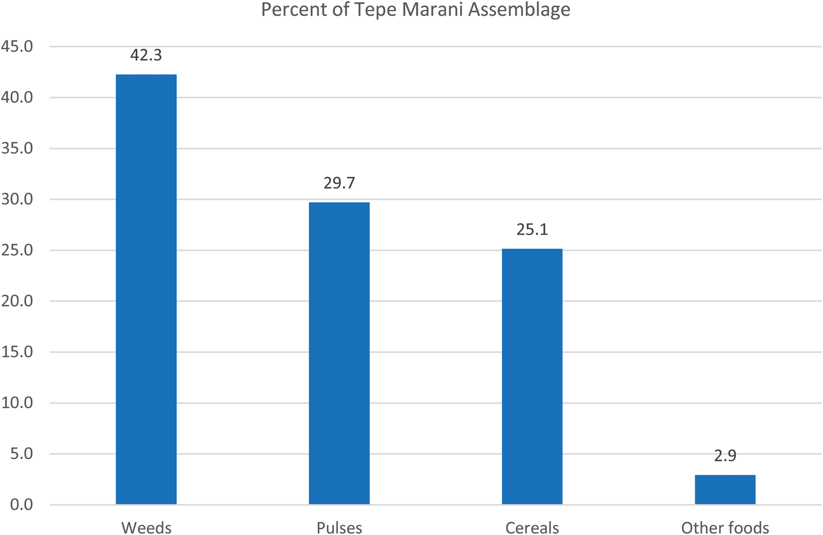
Breakdown of food crops from Tepe Marani.
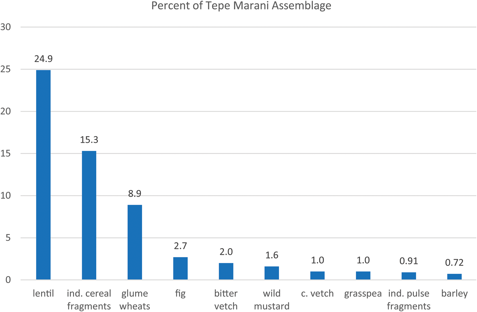
Of particular interest is the high proportion of two species of wild seeds: 110 seeds of wild oats (Avena sp.) in conjunction with remains of lentils and wheat grain fragments; and Brassicaceae seeds, preliminarily identified as a wild mustard (Descurainia sophia), commonly recovered from other Neolithic sites in the Near East. This wild mustard is well known for its oil content and has been frequently recovered in high quantities from storage facilities from the Neolithic site of Çatalhöyük (Bogaard et al. Reference Bogaard, Charles, Livarda, Ergun, Filipovic, Jones and Hodder2013).
The overall results of macro-botanical analysis are supported by phytolith analysis, conducted on samples collected from middens, surfaces, and pottery scatters at Tepe Marani and Gurga Chiya in 2013. These additionally reveal the presence of wetland plants, predominantly sedges, in the later prehistoric levels on both sites, where they are likely to have been used in the manufacture of mats and baskets. Analysis of offsite phytoliths and related sediments indicate a mid-Holocene environment characterised by interspersed river systems, riparian woodland, and patches of grassland associated with pasture and/or cereal cultivation.
Charred food remains from Gurga Chiya (Level 2, Late Ubaid) and Tepe Marani
As part of the archaeobotanical analysis, charred food remains were analysed from ten flotation samples from Tepe Marani and six from Late Ubaid levels at Gurga Chiya. The occurrence of this type of material is lower than from the previous season, despite the sampling of possible cooking features. These remains were initially examined under low-powered binocular microscope (0.8 to 4.0 magnification) in order to identify plant cell structures, which were then further studied using Scanning Electronic Microscopy.
For both sites, observation under SEM showed visible areas of cereal epidermis and endosperm cells embedded in a starchy matrix, which suggests the use of cereals processed into different types of flours, such as fine flour, bulgur or cracked grain.
Amongst the food samples, the majority of recognisable plant components are fragments of aleurone layer cells and bran cells at both sites. Bran fragments were found to be highly degraded and identification to cereal species was not possible. However, single celled aleurone layers, only found in wheat species, were identified at both sites. These particles were of small size (<600μm) which, according to a recently developed methodology for the study of amorphous charred remains of cereal foods (Gonzalez Carretero et al. Reference Gonzalez Carretero, Wollstonecroft and Fuller2017), could be linked to the use of finely ground cereal flour in their preparation. Additionally, different types of matrices or food microstructures have been identified among the analysed food fragments: a food matrix type 1, with few and small visible particles and large close voids (air bubbles) which cover a high percentage of the microstructure surface; and a food matrix type 2, with few small visible particles in which the air bubbles or voids are micropores (100–200 μm) and cover more than 30% of the surface. These two food matrices have been found to be similar to experimentally prepared “doughs” (matrix type 1) and “flat breads” (food matrix type 2). These were identified at both sites.
No evidence of rising agents such as yeast have been identified in the analysed food fragments from Tepe Marani and Late Ubaid Gurga Chiya, so on present evidence we can suggest that bread was prepared and eaten in unleavened forms throughout the Late Neolithic and Ubaid periods at these sites.
Preliminary raw material survey for lithics
At the end of May 2014, a small survey in the Shahrizor Plain was carried out, targeting the Western Zagros High Folded and Zagros Suture zones (roughly along the present Iraqi-Iranian border), which covers areas with packages of highly deformed bedded chert, shale and cherty limestone (Jassim & Goff Reference Jassim and Goff2006). Chert was found in locations near modern villages of Byara and Gulp. At Gulp, chert could be seen in road cuts and erosional surfaces, usually forming beds in the rock matrix or lose irregular blocks. So far white, greenish and translucent bluish cherts have been seen. Bluish chert is visibly cracked in the exposed section and its suitability for knapping will have to be further assessed. Chert of these colours is present on the sites from this study, and it is reasonable to assume it was procured directly from that area. It is equally likely that chert was collected from the local wadis. The rounded shape and smooth, very thin cortex of the preliminarily worked nodules found at Tepe Marani suggests a river environment origin. Larger wadis, such as the one visited during the survey near Gulp, and which are located in the Zagros Suture Zone, were likely to have been exploited, as blocks of chert 30–40 cm wide could be easily found there.
Conclusions
General Comments
Excavations at Gurga Chiya and Tepe Marani have provided baseline data for the environment and human occupation of the Shahrizor plain during the sixth and fifth millennia B.C. Our insights into the Late Halaf and Late Ubaid point, as expected, to two very different societies with widely divergent attitudes towards material culture, for example the differences in usage and production of both lithics and ceramics, while at the same time sharing the same basic elements of the subsistence economy, within similar or identical environments. Ongoing analysis of animal remains may change this picture. We currently lack data relating to the transition between these societies, i.e. the early Ubaid during the late sixth and first half of the fifth millennium B.C., which most probably lies buried at Gurga Chiya.
In the discussion below we focus on what we consider to be the major new insights and additions to the data relating to the Ubaid period, namely the close affinities between the cultural assemblages of the Shahrizor and the Hamrin during the Late Ubaid (as opposed to the Northern Ubaid); the possible absence of the LC1 horizon in the region, which is likely to be related to the first phenomenon; the implications this holds for the subsequent Uruk Expansion in the region; and the implications for household production of hardware and food, with reference to the autonomy of Ubaid-period domestic economy.
Affinities and chronological discrepancies with southern and northern assemblages during the Ubaid and early LC Periods
While ongoing excavations at nearby Tell Begum have begun to provide complementary data relating to Tepe Marani and the Late Halaf, the local and regional context of the Late Ubaid levels at Gurga Chiya remains poorly defined. Rescue excavations by the Sulaimaniyah Directorate of Antiquities took place at two Ubaid sites: Greza, 25 km to the northwest of Gurga Chiya, and Tanjero, 54 km to the northwest (Saber et al. Reference Saber, Salman, Rasheed and Mühl2014). These yielded painted Ubaid pottery classified as Late Ubaid, and both sites (Levels I-II at Tanjero in particular) produced pottery parallels with Gurga Chiya, although their other ceramics indicate an earlier date in the Ubaid. It is therefore possible that Levels I-II at Tanjero are close in date to the excavated Ubaid levels at Gurga Chiya. The finds assemblage at Tanjero has some elements in common with finds from Gurga Chiya (a polished stone axe, small animal figurines), but also produced elements which are rare or absent from the latter, including bent clay mullers and a comparatively high number of spindle whorls (Saber et al. Reference Saber, Salman, Rasheed and Mühl2014: fig. 13: 17, fig. 14).
At Begum Ubaid and LC pottery is reported, but in situ levels have not yet been identified (Nieuwenhuyse et al. Reference Nieuwenhuyse, Odaka, Kaneda, Mühl, Rasheed and Altaweel2016: 113, 120). Outside the Shahrizor Ubaid levels were identified at Girdi Qala and Logardan, 100 km to the west-northwest near Chamchamal (Vallet et al. Reference Vallet, Baldi, Naccaro, Rasheed, Saber and Hamarasheed2017: 65, 67; Vallet Reference Vallet and Vallet2016: 9, 13; Paladre et al. Reference Paladre, Al Debs, Amin and Vallet2016: 95), but so far they have not been investigated. Kani Shaie, c.100 km northwest in the Bazyan region, also has remains of the LC, including material contemporary with the LC4 levels at Gurga Chiya, i.e. forms characteristic of the southern Uruk such as string cut cups, nose-lugged jars and Bevel Rim Bowls (Tomé et al. Reference Tomé, Cabral, Renette, Kopanias and McGinnis2016: fig. 4).
Around 200 km to the northwest, Ubaid material is found in Operations 1, 2, 9 and 10 at Surezha (Stein and Alizadeh Reference Stein, Alizadeh and Stein2014, Reference Stein, Alizadeh and Stein2017; Stein Reference Stein and Stein2018). At Surezha, however, levels which would have been described as Ubaid at Gurga Chiya on the basis of their ceramics were described as LC1 (see below). Not far from Surezha, on the outskirts of Erbil, Tell Nader has yielded Ubaid period kilns, burials and painted pottery, as well as a possible Ubaid sherd with chevron-incised decoration and a fragment of Dalma impressed ware, albeit the latter both identified as Hassuna (Kopanias Reference Kopanias, Beuger, Carter, Fox, Hadjikoumis, Kourtessi-Philippakis, Livarda and Macginnis2013: 53, fig. 23: 1–3). Excavation has so far been limited at Nader, however, and the rest of the Ubaid pottery suggests an earlier Ubaid date than the Gurga Chiya building. Likewise, survey and excavations at nearby Helawa have produced a Northern Ubaid pottery assemblage of likely earlier date than Gurga Chiya, as indicated by the quantity of relatively fine open bowls with horizontal registers of decoration below the rim (Peyronel and Vacca Reference Peyronel and Vacca2015: 108).
The nearest comparable Ubaid assemblages of significant size are therefore found in the Hamrin, 130 km to the southwest, particularly Madhhur. The earlier Hamrin sites (Abada, Songor A-C, Tell Rashid, Kheit Qasim III, Abu Husaini and others) provide fewer parallels, as expected, though certain elements are held in common which indicate a suite of long-standing local characteristics shared with the Shahrizor (for example Painted-and-Incised ware and chevron-incised pottery). In contrast, comparisons with Northern Ubaid sites are generally poor (Tepe Gawra, Arpachiyah, Tulul eth-Thalathat, and sites in the Khabur, Balikh, Upper Euphrates and Upper Tigris). This agrees with Baldi's hypothesis of a “ceramic province” which covers the central Zagros (including Shahrizor), Hamrin and the Diyala, which persisted from the Samarra/Choga Mami Transitional phase through to the LC1 (Baldi Reference Baldi and Iamoni2016a: 118–9, 128). Baldi and Abu Jayyab (Reference Baldi, Abu Jayyab and Marro2012: 170) noted a breakdown of this province “between late Ubaid and LC 1”, with strong regionalisation tendencies setting in. However, we consider the close parallels shared between Gurga Chiya and Madhhur, coupled with the radiocarbon dates from Gurga Chiya, to indicate continuing close connections between the Shahrizor and Hamrin during and beyond the conventional date range of the Late Ubaid in the north. As noted below, this may help explain some of the chronological discrepancies when one tries to fit the Gurga Chiya sequence into the northern LC sequence.
Regarding chronology, a remarkable discrepancy arises with the radiocarbon dates from the 2013 season at Surezha, where a series of seven dates for the horizon defined as LC1 calibrates to between c. 4840 and 4620 B.C. (Stein and Alizadeh Reference Stein, Alizadeh and Stein2014: 149–150, Table 2). Even earlier dates were produced by the 2017 season, with the Surezha LC1 dates falling between c. 5200 and 4830 cal. B.C., with a likely range of 5100–4500 B.C. proposed for the LC1, and 5500–5100 B.C. proposed for the Ubaid (Stein Reference Stein and Stein2018: 31, 42). Thus the suggested range for the LC1 at Surezha is 100–600 years earlier than the Late Ubaid range of c. 4460–4370 B.C. that we propose for Gurga Chiya, which we would expect to precede the LC1. Stein and Alizadeh (Reference Stein, Alizadeh and Stein2014: 149) also note that the LC1 begins at c. 4500 B.C. in the Upper Khabur and Balikh regions of Syria, around one century earlier than the Late Ubaid horizon at Gurga Chiya.
On the one hand these discrepancies imply that the Erbil region, and perhaps the whole northern Tigris, Khabur and Balikh regions, saw the termination of the Ubaid ceramic assemblage several centuries earlier than the Shahrizor and Hamrin. On the other hand, we note that major elements of the painted ceramic assemblage designated as LC1 at Surezha would have been used to identify the assemblage as Ubaid at Gurga Chiya, including bowls with swag decoration (Stein Reference Stein and Stein2018: fig. 7: 2, 4; fig 8: 1), dishes or bowls with splaying rims and black-painted decoration below the rim (ibid.: fig. 7: 1, 3), and closed jar rims with interior ledges (ibid.: fig. 8: 5). Other elements which were considered part of the Ubaid assemblage at both Gurga Chiya and the Hamrin sites include vessels with incised chevron or herring-bone pattern (at Abada and Madhhur), and Dalma Impressed Ware (at Abada), both also found at Surezha in the assemblage and designated LC1 (ibid.: 34 and fig. 11).
A reconsideration of the cultural-chronological designations of the ceramics of Surezha and Gurga Chiya (and Madhhur) may therefore be merited. However, even if the LC1 at Surezha is re-designated as Late Ubaid, or the Late Ubaid at Gurga Chiya is re-labelled as LC1, the highly discrepant radiocarbon dates suggest that a pocket of stylistic conservatism lingered in the Shahrizor and Hamrin basins, with a belated transition from a prolonged Late Ubaid to something more like the later LC ceramic phases, bypassing the LC1 and perhaps moving more in step with southern developments. Indeed, the appearance of an LC2 phase with a dominant southern Early Uruk aspect at the relatively close Qara Dagh sites (see below) supports a strong southern connection, though LC1 is also reported there (Paladre et al. Reference Paladre, Al Debs, Amin and Vallet2016: 95; Baldi Reference Baldi and Vallet2016b: 113), indicating a further gradation between southern and northern Mesopotamian cultural provinces during the late fifth and early fourth millennia B.C.
In this regard we note ongoing work at Helawa on the Erbil Plain, just 9km from Surezha, which may confirm whether the area north of the Little Zab has a different Chalcolithic cultural trajectory to the Shahrizor and Qara Dagh. Although Peyronel and Vacca note that “clear LC1 markers of the Iraqi Jezira and Tigris piedmont ceramic horizon (such as Sprig Ware jars and bowls, U-shaped urns and footed bowls; Rothman 2001, fig. 10: 1) have not been found in any of the collection units of the Helawa survey” (Reference Peyronel and Vacca2015: 111), excavations at Helawa have revealed levels with discrete LC2 and LC1 assemblages, respectively Phases 3–4 and Phase 5 (Reference Peyronel and VaccaPeyronel and Vacca forthcoming). This implies that the LC1 was not “skipped” there as it appears to have been at Gurga Chiya, though Peyronel and Vacca (forthcoming) also note that the Phase 5 material includes painted motifs derived from the Ubaid. Radiocarbon dates from Helawa are anticipated, and a close comparison between the Phase 5 assemblage of Helawa and the Level 2 assemblage of Gurga Chiya must await future study. Such data will help resolve whether conservative southern, Hamrin-like assemblages endured longer in the Shahrizor area than in the north and northwest.
Role of Shahrizor and Qara Dagh in the Uruk Phenomenon
The new data from Gurga Chiya Level 1 confirm the appearance of an almost complete southern “Middle Uruk” ceramic inventory during the LC4, without any characteristic local LC ceramic forms such as Casseroles or Hammerhead bowls, though further work is required to confirm thisFootnote 5. Southern Uruk style material is becoming increasingly apparent in the region, with the most pertinent parallels in Uruk pottery and industrial installations found at Girdi Qala, c. 100km to the northwest in the Qara Dagh region, with related material nearby at Logardan, and other examples at Kani Shaie (Tomé et al. Reference Tomé, Cabral, Renette, Kopanias and McGinnis2016). The excavators assign Girdi Qala and Logardan to the Early Uruk, on the basis of the presence of local LC2–3 types accompanying the dominant element of southern style Uruk pottery (Vallet et al. Reference Vallet, Baldi, Naccaro, Rasheed, Saber and Hamarasheed2017: 76–80). They have not yet identified a clear LC1 horizon.
While the researchers in Qara Dagh envisage an Uruk intrusion along the Tigris, beginning earlier than expected during the LC2–3 (Vallet et al. Reference Vallet, Baldi, Naccaro, Rasheed, Saber and Hamarasheed2017: 75), we propose that the Shahrizor and Qara Dagh regions already shared substantial cultural affinities with regions to the south during the Ubaid period and saw continuing ties with the Hamrin and the southern alluvium, leading to a prolonged Ubaid followed by the development of an assemblage that combined Early Uruk ceramic styles with northern LC2–3 types.
This co-development with the Hamrin (and beyond that the southern alluvium), which includes the possibility of a local emergence of the Early Uruk aspect of the Qara Dagh assemblages, calls into question the whole basis of the Middle Uruk expansion into the Upper Tigris and northwestern Iran. Rather than regarding it as an outcome of initiatives that started in southern urban centres, it is feasible that the “Uruk Expansion” into the northeast of Iraq, eastern Anatolia and northwestern Iran was a largely independent extension of activities of the communities already located in this part of northeastern Iraq (i.e. the southern regions of Sulaimaniyah governate, and most likely Kirkuk governate), which occupied an ideal intermediary position in terms of both logistical communications and cultural interposition.
Production, Storage, Specialisation and Labour in the Late Ubaid
Significant changes can be seen in the decoration and meaning of ceramics during the centuries separating the Late Halaf and Late Ubaid at Tepe Marani and Gurga Chiya. The highly decorated and individualised ceramics of the Late Halaf stand in contrast to the plain, roughly finished pottery of the Late Ubaid. Within the latter assemblage, a limited range of broadly standardised types can be discerned (particularly basins with extended rims, angle-necked cooking pots, and simple bowls), but the level of standardisation within these types appears to be relatively low in terms of precise form, size and finishing. We note that although bowls are plentiful at Gurga Chiya, nothing yet clearly indicates the serial production of mass produced bowls (MPBs), comparable to the Coba tradition and other varieties of MPB (Baldi Reference Baldi and Marro2012). Some of Gurga Chiya's Late Ubaid bowls may be described as Wide Flower Pots (a variety of MPB), but they are not present in anything like the vast quantities noted at contemporary sites to the northwest.
The general approach to ceramic production in the Ubaid levels at Gurga Chiya privileges utility over aesthetic outcomes, and also over precise standardisation. It has been suggested that the overall simplification of domestic pottery assemblages across the broader region at this time points towards significant changes in the nature of hospitality and commensality, which may indicate a renegotiation of gendered roles within and between households (Wengrow Reference Wengrow2001). The assemblage from Gurga Chiya affirms this picture in its broad outlines, while also reflecting complexities at the local level. A switch to mass production has not yet taken place, though some ceramic wares and forms appear to be more standardized than others; multiple systems of production may have coexisted with the same community (cf. Arroyo Barrantes Reference Arroyo Barrantes and Iamoni2016: 140), and further study of this aspect of the assemblage is required.
With regard to food production and storage, the lentil storage facility in Room 1 also indicates significant changes since the Halaf period. The room is likely to have contained at least this particular household's requirements for lentils, and perhaps even an annual surplus, allowing the potential for exchange. This stands in contrast to earlier approaches to food storage where large communal facilities serving entire villages were used, most notably at Sabi Abyad but also at Umm Dabaghiyah and Yarim Tepe (Frangipane Reference Frangipane2007: 157; Akkermans and Verhoeven Reference Akkermans and Verhoeven1995). By contrast, at Gurga Chiya, as at the earlier Ubaid site of Abada, storage of at least some staple foods was undertaken on a household basis, implying that large households functioned increasingly as independent economic units. Moreover, at Ubaid period Kenan Tepe, it appears that cereals were processed on the roof, providing evidence that this particular household was responsible for the processing of its own crops. Since the building in question and its contents are otherwise quite typical of Late Ubaid assemblages elsewhere, there is every reason to think that it was also typical in this respect.
We are not the first to make the observation that Ubaid period households appear to have functioned as economically autonomous or semi-independent units (see especially Frangipane Reference Frangipane2007). There is no reason to interpret this as indicative or predictive of a general increase in social inequality, an approach derived from an assumption that this period should mark a step towards “state formation”. Bearing in mind that trajectories to state formation rarely have a simple or linear character (Yoffee Reference Yoffee2005), it is equally possible that household autonomy and specialisation in northern Mesopotamia set the stage for an extended network of mutual aid or seasonal resource buffering between Late Ubaid societies, distributed across contrasting ecological niches. The diversity of household assemblages both within and between sites suggests a corresponding diversity of responses, as certain families and communities became culturally invested in the acquisition of exotic prestige goods (e.g. imported stone and metals), while others show little or no such evidence (as in the excavated portion of the house at Gurga Chiya).
We conclude that the relative homogeneity of Late ‘Ubaid architecture, and to a certain extent the ceramic assemblages, may in fact mask a great deal of this diversity (Wengrow Reference Wengrow1998: 790–791), which can only be revealed through further detailed investigation of local sequences and material culture.