


I
The intertwined history of visual print culture and empire building in late seventeenth-century Venice is the subject of this article. Its main focus is the last phase of Venetian maritime expansion between 1684 and 1699 – a period marked by a spirit of aggressive military conquest which culminated in the acquisition of the peninsula of the Morea (Peloponnese) and the island of Santa Maura (Lefkada) in Greece and a series of gains in Dalmatia.Footnote 1 During these years, the Venetian expeditions overseas produced an overwhelming amount of printed images at home – far more than any other event in the city's history, to the best of my knowledge. Although a few studies have acknowledged the importance of this visual material to the history of political information in Venice,Footnote 2 neither the role of imagery in the production of imperial spectacle nor the ways in which military expansion shaped Venetian visuality have been properly examined. This article, therefore, seeks to address two key questions: first, how did visual representations of the empire generated in the institutional context of the Venetian army gain new meanings as they entered the realm of public life to grip the attention of a wide metropolitan audience? And, second, what can a historian discover about the production of Venetian geographical imagination through examining these prints and illustrated books?
The first part of this article explores the links between the military's knowledge production and the Venetian marketplace of print. Printed images were a meeting point between eyewitness army intelligence and commercial visual culture. In particular, military engineers, officers, and surgeons usually played a defining role in the production of visual knowledge about the empire through the design and use of maps as instruments of reconnaissance and territorial management. Many of these hand-drawn materials took on a second public life through print and thus reached a multitude of viewers beyond the military and political elites. As will be shown, reconstructing the process of conversion of manuscript maps into prints underscores the intricate relationship between Venetian politics and the publishing business, and illuminates the function of engravings as visual forms of a ‘banal militarism’Footnote 3 that infused everyday culture with martial themes and imperial fantasies.
The second part of the article takes this rich visual archive as a starting point for rethinking Venetian print culture through a close examination of the images produced by war and colonialism. For the most part, scholars have viewed Venetian visual media as another aspect of news discourse, assuming that they simply served to satisfy the curiosity of a public eager for information about the war against the Ottoman Empire.Footnote 4 However, this particular conflict was not simply yet another of the many wars which the Republic fought against the Turks; this was an expansionist campaign or, as one scholar put it, a quintessential ‘imperial venture’Footnote 5 aimed to revive the age-old dream of recovering dominion over the peninsula of the Morea. Being the first time the Republic declared war upon the sultan, followed up by a series of offensive campaigns to capture Ottoman-held territories, this chain of events challenges the myth of the Serenissima as a peaceful republic of merchants that engaged only in defensive wars to protect its threatened existence. By contrast, the expeditions of 1684–99 provide a powerful case-study of the impact of colonial warfare on Venetian culture and politics during a time that much of the historiography has associated with Venetian imperial decline. In this context, the article aims to show that image-making technologies, such as maps and prints, played a vital cultural role as a means of constructing domestic support for the Republic's late seventeenth-century project of imperial revival: they did so through a variety of strategies, including the projection of the justness of the war, the use of patriotic rhetoric, the deployment of the religious symbolism of St Mark, and the mobilization of hatred against the enemy. Focusing on the visual archive of this war enables us to ask broader questions about both the capacity of images to constitute and communicate facts about the Venetian empire, and the ways in which the optics of colonial power influenced popular visual imagination at home. Ultimately, an appreciation of the central role of visual experience in wartime Venice can deepen our understanding of the dialectical relationship between overseas expansion and image-making in the history of early modern empires: in much the same way as Venetian imperial rule in the Mediterranean and rivalry with the Ottomans affected metropolitan visual culture, the field of spectatorship also mediated colonial politics and shaped the experience of empire, particularly for those Venetians who never set foot on their city's colonies.
II
In 1705, the official cosmographer of the Republic Vincenzo Maria Coronelli proudly asserted that Francesco Morosini, commander of the invading Venetian forces in the Morea and Attica between 1684 and 1688, had told the Senate that ‘he had greatly benefited’ from his ‘geographies, which he had found exact’.Footnote 6 A few years earlier, Morosini's secretary, Alessandro Locatelli also noted in his Racconto historico – a book illustrated by Coronelli – that aboard the general's galley there were ‘two small tables, with various hydrographical charts for navigation, plans of fortresses and fortifications, and more books of similar content’.Footnote 7 This emphasis on the close connection between cartography and the military control of the seas was not an isolated occurrence, but a central aspect of Venice's long-standing tradition of using maps for nautical, military, administrative, environmental, and colonial purposes.Footnote 8 Indeed, as early as the fifteenth century, mapmaking had become inextricably linked to the development of Venetian state sovereignty, shaping the ideas and practices of political rule through its function as a tool of imperial governance and a symbol of territorial authority.
Venetian cartographic production intensified significantly in wartime periods to support military operations and enable visual control over newly acquired territories. The late seventeenth-century war with the Ottomans was no exception to this trend, as in this case, too, a new torrent of images surged from the battlefields of the Levant to show the new imperial acquisitions back in Venice. The flood of maps drawn up by army engineers and sent to the Senate through the dispatches of military and imperial governors confirms the central importance of cartographic visualization to Venetian expansionary operations. Yet, despite some contributions from sporadic studies, this extensive visual archive has not been systematically analysed.Footnote 9 This is somewhat surprising given the growing scholarly interest over the past few decades in the relationship between cartographic mapping, spatial thinking, and imperial geopolitics across different periods and academic fields.
This article relies on and aims to contribute to a recent scholarship that studies the visual regimes of colonialism and the constitutive role of image-making technologies in empire building. By examining the ways in which maps became implicated in Venetian expansion, constructed visions of colonial landscapes, and underwrote imperial governmentality, it places Venetian cartography at the intersection of visual culture and post-colonial studies to highlight what Sumathi Ramaswamy calls ‘the work of vision in the age of European empires’.Footnote 10 Furthermore, this article seeks to add to the growing scholarship on the history of archives and archival practices.Footnote 11 Although ‘archivality’ and ‘archival knowledge cultures’ have provided an exemplary arena for exploring the close connections among bureaucratic record keeping, political information, and the exercise of power, most of these studies have only focused on the written and textual records of early modern European states. Instead, the production of visual documents has been largely neglected in this particular context, while the nature of maps as a principal ‘recordkeeping technology’Footnote 12 has not been fully appreciated. As Venetian imperial cartography shows, the visual archive of colonialism expands the textual archives of early modern state formation and provides an important case-study of what new insights we can gain from this double epistemological and methodological shift – from the textual to the visual and from state to empire.
A detailed analysis of all the manuscript maps generated by Venice's last imperial expansion exceeds the purpose of this article, but they share an important characteristic that is central to my argument. All these maps constituted confidential material of high strategic value produced by the imperial military apparatus. Mapmaking is a core element of military intelligence, the building of a secure colonial state, and the army's function as an institutional machine of visual knowledge. Existing literature often takes this aspect for granted but, as will be shown below, this has far-reaching consequences on how we understand the role of the military in Venetian politics and culture and the ways in which the spectacle of empire in Venice evolved at the intersection between commercial printmaking and images created by the army, government agencies (e.g. provveditori alle fortezze), and state-supported institutions (e.g. the official cosmographer).
Given the centrality of visual information to Venetian colonialism, the process of topographical mapping involved the deployment of the most accomplished engineers/surveyors and cartographers. Cartography, technology, and the army went hand in hand, and engineers were often protagonists in the history of the material transformations of Venetian state and empire building. For example, Giust'Emilio Alberghetti, a leading army engineer and superintendent of the cadastral survey of the Peloponnese, was famous for his experimental uses of geometry in military architecture as well as his Compendio della fortificatione (1694), a book on fortification systems commissioned by the patrician Sebastiano Mocenigo when he was capitan delle galeazze. Giust'Emilio belonged to an old family of artillery founders in the service of the Republic, and together with his brothers Orazio and Sigismondo – the latter, a gun inventor, ballistics expert, and author of books on the technology of armaments – worked on fortress engineering projects that refigured the landscape of the Peloponnese.Footnote 13 Similarly, the engineer Giovanni Bassignani, a key member of Morosini's retinue, had received extensive visual training in Padua where, according to his biographer, he excelled in ‘designing plans of cities and fortresses’, ‘drawing topographical maps with the most exact measurements’, and ‘describing camps, sieges, trenches, and similar things’. His dexterity with the compass and finesse of manual skills were thought to be so exceptional that ‘his drawings looked like impressions of copper magisterially engraved’. Indeed, his inventive talent and mastery of design earned him the patronage of Morosini and a distinguished position in the Republic's army, while his long experience in Austria and other parts of the Stato da mar gave him a key role in the campaigns of the Peloponnese, where he made crucial contributions to the sieges of Coron, Modon, and Napoli di Romania (Nafplio).Footnote 14
Through the illustrations, models, and surveys of such on-site experts with a ‘talent for drawing’,Footnote 15 government officials in Venice came to know their new dominions and formulate their military policies. For instance, in November 1687, Morosini sent the Senate a plan of Athens carried out by the engineer Giacomo Milhau Verneda and promised to dispatch a plan of Nafplio that was under preparation by the engineer Bassignani. A month later, Morosini also informed the Senate that Verneda, ‘equipped with appropriate instruments’, was about to draw a topographical plan of the Isthmus of Corinth, while in March 1688 the Venetian commander sent a plan of Mistras by the engineer Mauro.Footnote 16 Similarly, in August 1701, Captain General Daniele Dolfin dispatched a plan of the fortress of Prevesa by the French engineer Le Vasseur and another of Santa Maura by Francesco Antonio Vecchioni.Footnote 17 All these designs were accompanied by reports and explanatory notes linking the visual and textual together in a single argument that made them worthy not only of being preserved in state archives, but also of being copied by patrician officeholders for their own personal use. For example, the state historiographer Pietro Garzoni kept in his private archive various letters and scritture of Sigismondo and Giust'Emilio Alberghetti as well as those of other artillery officers who served in the Peloponnese.Footnote 18
Although such documents contained vital data that influenced decision-making in the field of military affairs, the deployment of specialists with visual expertise was not simply a question of information gathering and of delineating legible colonial spaces. Cartographic literacy and visual reasoning were invaluable skills both for army engineers and their patrician supervisors who, in a shared consultation process, dealt with questions of military planning, land management, and infrastructural work with ‘the drawings [kept] under their eyes’,Footnote 19 that is with the help of working sketches used as problem-solving devices. Nearly two centuries earlier, Baldassare Castiglione had written that the courtier-warrior should possess the art of painting in order to use it for military purposes.Footnote 20 Francesco Grimani's request to his brother Giovanni in 1687 exemplifies a similar way of thinking about military leadership, technical proficiency, and cartographic skills:
I wish that you send me that black box which I had once on my table [and] had inside various mathematical instruments – and these are compass, rulers etc. and now they are at their place in the cupboard in our library, because I want to become skilled in the study of fortifications.Footnote 21
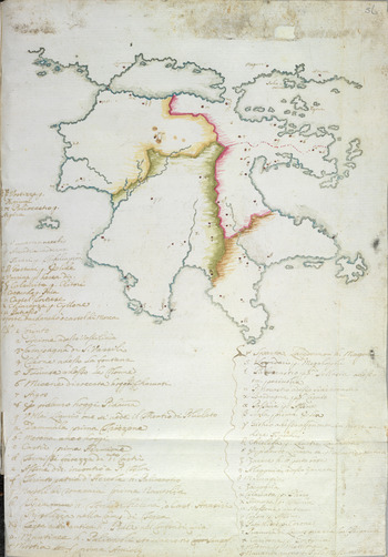
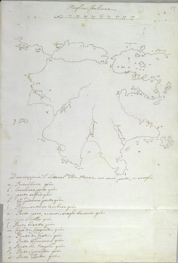
Alongside military commanders and engineers, surgeons also played a comparable role in the production of cartographic imagery. Given their specialized training in empirical observation and visual demonstration, early modern surgeons and physicians assigned particular importance to the visual presentation of knowledge. The learned physician of the Venetian fleet Alessandro Pini, for instance, compiled in 1703 a geographical and archaeological description of the Peloponnese which included two maps sketched by Sigismondo Alberghetti and Francesco Vandeyk, one of the principal engineers who conducted cadastral surveys of the peninsula.Footnote 22 These maps for long had been considered lost, but my research has found that they are kept today in the British Library in London, along with a copy of Pini's description of the Peloponnese.Footnote 23 The first map shows the sites visited by Pini himself and contains a comparative list of ancient and modern place-names, while the second marks the rivers, ports, and nearby islets of the peninsula (Figures 1 and 2). As a note on the last page of the copy held at the Venetian state archives implies, Pini intended to publish his work with the Venetian printer and bookseller Alvise Pavin. Although his wish does not appear to have been ultimately fulfilled, his publication plans highlight both the synergies between military men and commercial publishers and the manner in which visual materials arising from colonial exploration were often destined to reach the eyes of the Venetian reading public.
Manuscript map of the Peloponnese, in Alessandro Pini, IL PELOPONESSO, ò vero le sette Provincie di quel Regno descritte da Pausania, illustrate, e ridotte al moderno, 1703. © The British Library Board, Add. 41304, fo. 56r.

Manuscript map of the Peloponnese, in Alessandro Pini, IL PELOPONESSO, ò vero le sette Provincie di quel Regno descritte da Pausania, illustrate, e ridotte al moderno, 1703. © The British Library Board, Add. 41304, fo. 57r.

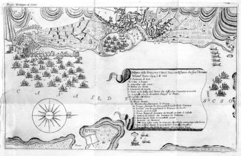
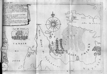
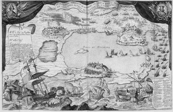
This alliance between military men and printers is equally evident in the anonymous book Dell'acquisto e del ritiro dei Veneti dall'isola di Scio nell'anno MDCXCIV, written by a navy officer who took part in the short-lived occupation of the island of Chios in 1694. The stated aim of the book was to challenge the official version of events given by the state historiographer Garzoni and, to this end, it presented a selection of documents from the private archives of certain officers who were present during the operations at Chios.Footnote 24 Interestingly, the author also added a set of nineteen prints showing the changing positions of the Venetian and Ottoman fleets from the capture of the island in September 1694 to the retreat of the Venetian fleet from the port of Chios after the Ottomans reconquered it in February 1695. Anticipating the style of present-day cartoon strips, these prints linked together the different temporal episodes of the event in a dynamic visual narrative (Figures 3 and 4). As the author observed, the production of these images required hard and time-consuming labour, but he deemed the task worthwhile in order to ‘represent under the eyes the most remarkable truths of that enterprise’ and thus strengthen the ‘veracity’ of his argument. Indeed, these pictures were presented as supplementary, visual evidence to verify the story told in the text of the book and make eyewitness knowledge claims. In other words, while they conveyed factual information, these images also served the rhetorical purpose of providing a new dimension to the intense political debates in Venice surrounding the loss of Chios.
Engraving depicting the landing of Venetian troops on the island of Chios in 1694, in Dell'acquisto e del ritiro dei Veneti dall'isola di Scio nell'anno MDCXCIV (Nuremberg, 1710). Biblioteca del Museo Correr, Venice.

Engraving depicting the position of the Venetian and Ottoman fleets in December 1694, in Dell'acquisto e del ritiro dei Veneti dall'isola di Scio nell'anno MDCXCIV (Nuremberg, 1710). Biblioteca del Museo Correr, Venice.

Both Pini's description of the Peloponnese and the anonymous book on Chios introduce us to the multitude of visual materials through which military knowledge reinvigorated the Venetian printing sector at the end of the seventeenth century. Indeed, the military infiltrated print culture not only through descriptions such as the one published by the cleric Antonio Pacifico in his Breve descrizzione corografica del Peloponneso, which included cadastral data gathered by Giust'Emilio Alberghetti.Footnote 25 Battle scenes, plans of fortresses, siege views, and maps of military provenance flooded the marketplace of print transforming the militarization of colonial space into a spectatorial experience. The army's image-releasing role did more than just influence publishers’ choices, however. Rather, the military was instrumental in giving new life to Venetian printmaking by providing artists and publishers with fresh visual material for the production of new pictures. Pacifico, for instance, printed in 1704 a coloured map of the Peloponnese which Alberghetti had drawn by order of the Senate.Footnote 26
Although Venice had been a major capital of map production and print geography during the Renaissance, its printmaking industry was facing a protracted decline during the seventeenth century. By that time, most engravers had concentrated in Rome, while the shortage of skilful professionals in Venice was so acute that in 1681 the French antiquarian and professor of medicine at the University of Padua Charles Patin protested that he could not find ‘good engravers’ to illustrate his numismatic books.Footnote 27 The outbreak of war in 1684, however, revitalized Venetian print production and generated new employment opportunities for foreign artists who migrated to Venice, thus giving a strong boost to the art of intaglio printmaking. Most of these engravers arrived mainly as a result of a systematic initiative by the official cosmographer, Coronelli.Footnote 28 Owing to his status, Coronelli enjoyed privileged access to up-to-date classified military drawings and other state documents. This enabled him, for example, to produce engravings of Modon, Malvasia, and Chios based on plans by the engineers Antonio Giancix and Orazio Alberghetti and Captain Agostino Cerruti.Footnote 29 Another print showing the new fortifications at Napoli di Romania was ‘delineated and engraved’ by the patrician Vincenzo da Canal for the Accademia degli Argonauti, which Coronelli himself had founded in 1684 and whose membership included the captain generals in Dalmatia Girolamo Corner and Pietro Valier, who gave the cosmographer original maps and commissioned prints depicting their military operations.Footnote 30
Working either for Coronelli or other print entrepreneurs, engravers produced numerous pictures that took military drawings outside the army and circulated them widely across the public domain. By spilling out into the world of print, military images did not just turn into commercial copies of manuscript drawings. In some cases, printmakers produced simplified versions of the original, while in others they added new text to clarify the meaning of the image or graphic elements to enhance its symbolic content and commercial appeal. Sometimes, independent prints reappeared in books, usually without commentary, as long as they were somehow loosely connected to the theme of the volume. More frequently, they were pasted directly onto a thin layer of paper inserted among the pages of the book. Thus, illustrated volumes about the war often included copies of single-leaf impressions that were sold independently.Footnote 31 Moreover, commercial competition forced different publishers to collaborate with the same engravers and even use the same metal plates to cut printing costs. In reality, this practice followed the long-standing commercial tradition of copying and reprinting older products, which was an effective way of disseminating pictures since the invention of the printing press.
Advertising was another means of introducing military representations into the world of the book trade. As Chandra Mukerji has argued, pictorial prints were the first mass-produced goods for popular consumption that contributed to the rise of consumerism in early modern Europe.Footnote 32 Advertising was an important aspect of the business of printmaking, yet its role in the emergence of a commercial visual culture often tends to be too easily overlooked. The advertisement of images in Venetian books shows how publishers used this communicative form to attract readers’ attention and stimulate sales. More importantly, the presence of such consumer-oriented messages illustrates how marketing techniques created commercial visions of empire and promoted Venice's new imperial geography. In a newsletter about the antiquities of Athens printed by Antonio Bosio, one advert said:
In Venice at S. Maria Formosa, with the license of the superiori for Antonio Bosio…at the Rialto bridge at the sign of the Fede are on sale. On sale is also the general geographical map of the Morea, with the plan of the cities around and a distinct notice of those places.Footnote 33
Such ads invited everyday Venetians to celebrate the spoils of the imperial adventure by involving them in the visual production of the army. For instance, the stampator ducale Antonio Pinelli used his newsletters to inform readers that ‘the design of the plan, attacks and expugnation of the fortress of Castel Novo drawn in the battlefield by Girolamo Zorzi Calergi…has arrived’ (Figure 5). Another advert said that ‘at the printing shop of Girolamo Albrizzi the book titled Description of the island of Scio will appear with the diario of the conquest of the island, and its plan, which came from the fleet, is on sale for 16 soldi’.Footnote 34 Albrizzi used a broad array of publications to advertise the release of new geographical and cartographic material. Thus, through his literary journal La Galleria di Minerva he promised a new game of cards titled Geografia in giuoco, a set of illustrated playing cards in which, ‘apart from the enjoyment of the game, one enjoys in summary the entire Geography’.Footnote 35 But it was mainly through his periodical military journals that he publicized commercial images of conquered cities and battle scenes. Here are two typical examples:
The plan of the city of Corinth, which came from the fleet and will be put on sale for 16 soldi, is sold by Girolamo Albrizzi in Campo della Guerra at St Giulian;
The print of the true plan of Negroponte which came from the battlefield is completed, with the siege and advances of our men, sold for 16 soldi.Footnote 36
The Venetian conquest of Castelnovo (1687), in Giacomo Franconio, Teatro delle più moderne imprese de guerra fatte si nell Ungheria come nella Dalmatia Morea et altri luoghi (Venice, [1689]). Biblioteca Estense Universitaria, Modena (su concessione del Ministero dei beni e delle attivitá culturali e del turismo).

Textual advertising shows how the commercial imperative to seize consumers’ attention led printers to promote their prints as trustworthy and unmanipulated documentary records. This marketing strategy appealed to the dominant perceptions of the period about the evidentiary value and usefulness of images as instruments of knowledge.Footnote 37 The ability of prints to offer what William Ivins has famously called ‘exactly repeatable pictorial statements’Footnote 38 increased their authority as channels of allegedly reliable visual communication. Words like true, distinct, and new were often deployed in the titles to certify the accuracy of images and guarantee their grounding in real events recorded in official drawings by eyewitness army engineers.Footnote 39 As historians of science have shown, the authority of early modern scientific works was largely grounded in the social status of the practitioner, whose credibility and professionalism were enhanced by the use of specialized instruments and visual tools as means of proof and persuasion.Footnote 40 In the Venetian case, emphasis on the provenance of images from the fleet or the battlefield suggests that among the criteria which influenced consumers’ purchasing behaviour was the perceived cognitive authority of prints as repositories of high-level information authenticated by patricians and military experts whose names were associated with the highest levels of expertise in engineering and mapmaking. Finally, the potential impact of these advertisements was reinforced by the emotional relationship they established with their readers. As Albrizzi's ad of the plan of Negroponte with the operations ‘of our men’ suggests, publishers sold ideas of belonging and community, equating the act of purchasing prints with citizenship and the patriotic support of the Republic's imperial army.
Besides single-sheet engravings, printers also advertised colonial-themed picture books, like Pacifico's L'esatta notitia del Peloponneso by Albrizzi which was ‘adorned with its cities in copper’ and sold at 3·5 lire.Footnote 41 Similarly, a new volume on Crete listed ‘modern new curious books about the current wars of both the Venetians and the imperialists and others, sold by Leonardo Pittoni bookseller at St Mark’:
Anyone who wishes to know plainly about the wars and the conquests of the most Serene Republic of Venice, starting from the siege of St Maura until today, a new book is printed titled Il regno della Morea sotto i Veneti, with the drawings of all the fortresses of the Morea; it costs 1·15 lire.Footnote 42
It is hard, of course, to tell how successful these advertisements were in boosting the sales of prints and illustrated books. Contemporary objections to the proliferation of war maps and prints are nicely captured in a well-known satirical engraving by Giuseppe Maria Mitelli showing the unenthusiastic reactions of passers-by to the wares of an itinerant printseller.Footnote 43 Such examples, however, are rare, thus making issues of reception extremely difficult to assess. In contrast to the abundance of evidence left by publishers (shop inventories, commercial correspondence, company records, etc.), consumers seldom left traces showing how they responded to new editions. Nevertheless, a similar lack of evidence on readers’ behaviour has not prevented historians of the book from drawing useful conclusions through the study of bibliographical and archival sources relating to the distribution of books. From this point of view, promotional announcements provide valuable insights into the wide variety and price ranges of visual material sold in the market during the war and the ways in which printers engaged with their customers’ expectations, wishes and concerns. We also know that since the Renaissance, Venice was the leading producer of military books in Europe – from treatises on the art of war to manuals on siegecraft, artillery and fortifications – and local printers were keenly aware of the marketability of and wide readership for this type of literature.Footnote 44 Mitelli's aforementioned print further confirms that the years of the war were a highly productive and image-saturated time. War and empire reached relatively large numbers of people not simply in the form of written news and verbal conversations, but also as a flurry of commercial pictures vying for the attention of spectators on the move.
The promotional techniques used by Venetian publishers suggest that they were addressing a fairly well-informed consumer public, already in the habit of acquiring knowledge about the Mediterranean through images. For example, Pittoni's Historia, o sia vero, e distinto ragguaglio dello stato presente della città di Costantinopoli, e suo serraglio, published in 1686 and ‘sold at the ponte de Baretteri under the portico, at the sign of Hope’, was advertised two years later as a book containing additional ‘engravings and other curious news, which did not appear in the first edition’.Footnote 45 This announcement suggests that at least some readers were assumed to be familiar with the visual material in the first edition. In fact, the aim of advertisements was not merely to inform about new books and images, but also to train readers into the habit of anticipating innovations, until they tuned themselves to the market cycle by which these products appeared.
On the other hand, Venetian publishers were trying to lure potential buyers who were personally involved in the imperial venture either through tax payments and the purchase of government bonds,Footnote 46 or through social connections to military leaders and the political elite. As M. E. Mallett and J. R. Hale have noted, ‘informal links’ between the military and civilian spheres as well as the ‘integration of the army into the economy and society of the Venetian state’ distinguished the Republic's approach to military affairs from other Italian states.Footnote 47 During the War of the Morea, the links between the armed forces and the rest of Venetian society were particularly strong, while relations between the military and the civilian population were further solidified by the mediating role of cultural institutions. For example, the Accademia degli Argonauti brought together in the same tightly connected group patrician military commanders, army engineers like Sigismondo Alberghetti, state bronze founders like Giovanni Mazzaroli, political leaders and high-ranking bureaucrats, as well as ecclesiastics, doctors, and lawyers who were among the buyers of maps showing Venice's new territorial conquests.Footnote 48
Many of these cartographic images contained dedications to influential aristocratic and ecclesiastical patrons and were often bought by wealthy individuals who added them to more conspicuous status symbols, like the world maps and globes which adorned their palaces.Footnote 49 For instance, a 1688 engraving of Negroponte was kept at the archive of the Correr family, while prints of Navarino, Modon, and Maina could be found in the Grimani dei Servi archive.Footnote 50 These examples indicate that the relatively low cost of visual ephemera, whose prices ranged from 4 to 30 soldi and were usually fixed at 16 soldi, did not necessarily define their buying public but appealed to a wide cross-section of Venetian consumers. Perhaps manual workers, who earned between 35 and 60 soldi per day, could not afford to buy the most expensive of them; but craftsmen, who earned between 66 and 85 soldi per day,Footnote 51 most probably could. In effect, printed images were an integral part of the wider market of cheap print, which consisted of ephemeral vernacular works aimed at socially mixed audiences, both literate and non-literate, who received and appropriated them in a variety of different ways.Footnote 52
Taken together, these observations suggest that the process of turning technical army drawings into a new technological format that made imperial cartography accessible to different users outside the military and political elites was of profound social and cultural importance. Prints helped to define an imperial audience whose political and geographical knowledge acquisition consisted to a large extent of looking at pictures and seeing them in specific ways. The army was instrumental in shaping the images of the Levant in popular culture, as many people came to imagine the empire through a military perspective. Prints that served as news pictures of current events were in effect based on visual knowledge used to survey and enforce state control over colonial people and frame imperial strategies towards new territories. Thus, the flow of images from the empire to the metropolis is central to how we understand Venetian print culture, as are the military/colonial aspects of image production.
III
The main function of maps, as Denis Wood remarks, is that they ‘give us reality, a reality that exceeds our vision…a reality we achieve no other way’.Footnote 53 In late seventeenth-century Venice, engraved maps, fortification plans, and siege views offered the viewing public unique access to the virtual reality of the war. By bringing the distant territories of the Levant to the immediate view of spectators, prints were greatly valued for their ability to make war visible. In composing a gallery of militarized and colonial landscapes alternating like a kaleidoscope, they fascinated their viewers as they exemplified the classical topos of the theatrum mundi, the idea of the world as a theatre.Footnote 54
Already since the sixteenth century, the term ‘theatre’ was widely used by illustrated works on geography, anatomy, natural history, and technology.Footnote 55 The publication of Giulio Camillo's seminal work L'idea del theatro (1550) in Venice was central in disseminating the notion of ‘theatre’ as a visual encyclopaedia of knowledge. Camillo had built a wooden ‘theatre of the world which represented a summa of acquired knowledge with images’, using ‘a mnemotechnic machine capable of reflecting the intimate and profound genealogical and logical connections between things’.Footnote 56 The revival of the theatre as an institution and the construction of theatre houses, like the Teatro Olimpico in Vicenza (1580), reflected the dominant perception of the theatre as a memory machine. Similarly, the wooden ‘world theatres’ which floated on the Venetian lagoon during the Carnival season portrayed the city as a microcosm of the whole universe.Footnote 57
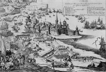
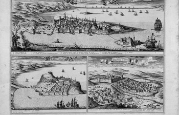
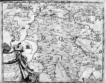
At the end of the seventeenth century, several illustrated volumes appropriated the notion of geography as a theatre of history, thus evoking the first printed atlas, Abraham Ortelius's Theatrum Orbis Terrarum (1570) – a work republished during the War of the Morea as a pocket book by the Venetian printers Giovanni Battista Brigna and Domenico Lovisa.Footnote 58 Through such picture books, the reading public could appreciate the range of images that were widely available in print format as the conflict with the Ottomans unfolded in the ‘theatre of time’.Footnote 59 In 1687, Giovanni Giacomo de Rossi produced in Rome his Teatro della guerra contro il Turco, an anthology of images which epitomized the wide range of iconographic material about the war. The volume included drawings of fortresses, siege views, satirical prints, battle schemes, the Ottoman advance to Vienna, and the march of the imperial army along the Danube (Figures 6 and 7). A year later, Albrizzi advertised Giacomo Franconio's Teatro delle più moderne imprese de guerra fatte si nell'Ungheria come nella Dalmatia Morea et altri luoghi, which was sold at the forbidding price of 16 lire. As the editor stressed, one could see in it ‘every detail of the sites, fortresses, places where remarkable military action took place in our times’(Figures 8 and 9).Footnote 60 The theatrical metaphor was also adopted by Coronelli in his celebratory volume Teatro della guerra: Morea, Negroponte et adiacenze (1708) and in his allegorical images of Venice framed by curtains that transformed prints into monumental war stages.Footnote 61 The presentation of print collections as mobile theatres of memory and history enhanced their perceived importance as rich sources of visual information about faraway places which also offered the pleasure of a theatrical performance. This link between geography and theatrical experience was further enhanced in the context of wartime pageantry, where the personified continents of Asia, Europe, Africa, and America were offered to Faith and the islands of Cyprus and Crete implored Morosini to free them from the Turks.Footnote 62
Arnold van Westerhout, Coron, in Gio’ Giacomo de Rossi, Teatro della guerra contro il Turco, dove sono le piante e le vedute delle principali città e fortezze dell'Ungaria, Morea, e d'altre provincie, con gl'assedii e conquiste fatte…sotto il felice pontificato di Innocenzo XI (Rome, 1687). Biblioteca del Museo Correr, Venice.

Engraving depicting Napoli di Romania, Malvasia, and Calamata, in Gio’ Giacomo de Rossi, Teatro della guerra contro il Turco, dove sono le piante e le vedute delle principali città e fortezze dell'Ungaria, Morea, e d'altre provincie, con gl'assedii e conquiste fatte…sotto il felice pontificato di Innocenzo XI (Rome, 1687). Biblioteca del Museo Correr, Venice.

La Morea, in Giacomo Franconio, Teatro delle più moderne imprese de guerra fatte si nell Ungheria come nella Dalmatia Morea et altri luoghi (Venice, [1689]). Biblioteca Estense Universitaria, Modena (su concessione del Ministero dei beni e delle attività culturali e del turismo).

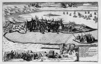
Engraved view of Napoli di Romania with an ‘arithmetic prognostication’ of its conquest by the Venetians, in Giacomo Franconio, Teatro delle più moderne imprese de guerra fatte si nell Ungheria come nella Dalmatia Morea et altri luoghi (Venice, [1689]). Biblioteca Estense Universitaria, Modena (su concessione del Ministero dei beni e delle attività culturali e del turismo).

Both illustrated volumes and single-sheet engravings presented the war and the new conquests through two popular visual typologies: urban iconography and fortress sieges. The rendition of the individual besieged fortresses and ports usually followed the high-prospect bird's-eye view which projected specific landmarks of the fortified area, like churches, mosques, administrative buildings, and major monuments in addition to the fortifications and harbours. By contrast, the extramural zone and the surrounding countryside, when not depicted as blank empty spaces, were presented in abbreviated form. These large-scale aerial city views and siege panoramas were typically promoted as topographical documents of undisputable cartographical accuracy, yet they did not serve simply as a form of military reportage. As the history of the bird's-eye perspective indicates, oblique maps were less a product of careful geometric measurement than an imaginative graphic celebration of cityscapes, military victories, and new conquests with the aim of instilling a sense of wonder among their viewers.Footnote 63 Like city maps, battle scenes were also drawn from an overhead viewpoint and shown in a highly dramatic manner, following the fashion of war paintings and historical accounts which aimed to achieve artistic and visual effects rather than a faithful description of the event. All these prints addressed an audience with basic reading skills and contained different kinds of text which aimed to tell viewers what to see by directing their eyes to specific points of the image.
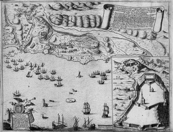
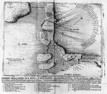
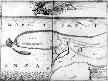
Since the early victories of the Venetian navy in 1684, printing shops in Venice churned out a large number of prints which promised accurate information based on authentic military designs. One of them, the Dissegno della piazza di S. Maura, e suoi borghi, showed a plan that had been drawn ‘alla sfugita’ by the engineer Sebastiano Alberti on the very day of the conquest of Lefkada (Figure 10). Through a strictly military perspective, emphasis was given on the pentagonal fortress shown in the middle and the movements of the Venetian fleet. The plan was complemented by a brief index naming military positions, the types of cannons used, and important landmarks of the battle intended to help the viewer capture the event in its entire complexity. Although the forty-three Venetian ships which took part in the battle are not drawn, their positions are clearly marked by their individual commanders’ names, most probably in an attempt to glorify the role of the patricians commanding the Venetian navy.
Dissegno della piazza di S. Maura, e suoi borghi (Venice, 1684). Biblioteca Nazionale Marciana, Venice.

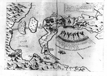
Another printed image of the same event, Antonio Bosio's Pianta della fortezza di S. Maura con l'isola di Lefcada (Figure 11),Footnote 64 shows how engravers went beyond the technicalities of military plans to transform prints into dynamic continuous narratives. The title box of this print announces the naval conquest of Lefkada under Morosini's command and refers to the island's long subjection to Ottoman rule. The main fortress is given added symbolic significance as it features a highly visible mosque with the inscription ‘Moschea adesso detta S. Salvatore’. The image of the bombarded mosque alludes to the importance of the battle as a religious and cultural conflict between Christendom and Islam, while the caption indicates the transfer of dominion from one religion and empire to the other. Interestingly, this caption fuses two separate moments into one, thus giving the impression that the Muslim mosque was turned into a Christian church during the very act of its bombardment. Similarly, the moment when the Venetian soldiers landed is an event that obviously occurred before the siege, while the conversion of the mosque into a church took place after the end of the battle. Furthermore, another episode in the print referring to a different time sequence is the capture of a group of Turks placed in front of Morosini's tent. In other words, four successive acts – the landing of the soldiers, the siege of the fortress, the surrender of the Turks, and the replacement of the mosque – are all depicted simultaneously so that narrative time and action do not get frozen in a static configuration. The informational content of the image is further enriched with details about the inhabited space outside the fortress: the houses of the Greeks, the aqueduct, a bridge with 360 arches, and the houses and minarets of the nearby towns of Arta and Prevesa are all presented in a comprehensive description which shows viewers the main landmarks of the new territory that Venice had just acquired.
Pianta della fortezza di S. Maura con l'isola di Lefcada (Venice, 1684). Biblioteca Nazionale Marciana, Venice.

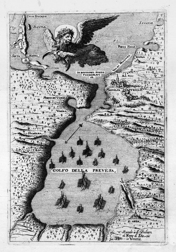
Images like those described above were produced in large quantity. This suggests that printers must have been keen on publishing battle scenes and siege views more often than maps. Much like religious narrative paintings, which brought together the most significant moments of a story in the same pictorial composition,Footnote 65 military action images also offered spectators the opportunity to scan multiple, temporally distinct episodes of a major event arranged on a single picture plane. Furthermore, prints of besieged cities and fortresses provided a vision of the empire as the sum of Venice's territorial conquests and seemed more effective in driving viewers’ engagement thanks to their dramatic news content and graphic effects. Although prints sometimes depicted basic fortification plans and geometrical designs, engravers generally sought to combine topographical information and figurative illustrations, some of which propagated anti-Ottoman sentiments based on a stereotypical crusade mentality. For instance, Franconio's print of the Gulf of Prevesa features the winged lion of St Mark breaking the Ottoman crescent, while his print of Corinth shows the enraged lion brandishing a sword above the bodies of dead Turks (Figure 12).
Gulf of Prevesa, in Giacomo Franconio, Teatro delle più moderne imprese de guerra fatte si nell Ungheria come nella Dalmatia Morea et altri luoghi (Venice, [1689]). Biblioteca Estense Universitaria, Modena (su concessione del Ministero dei beni e delle attività culturali e del turismo).

Although prints often combined abstract plans with decorative and iconographic elements, even simple, straightforward representations required certain visual skills on the part of the viewer in order to be fully understood. To make sense of the assumptions, ideas, and vocabularies built into an image, one had to be familiar with the key cultural codes and the established iconographical conventions of that time. In the case of engineering designs, fortification drawings conveyed different things to experts and laypeople as they presupposed different kinds of technological, mechanical, and geometrical knowledge not always visible on paper.Footnote 66 Certainly, schematic plans of fortresses were available for public view also through other forms of imperial display, such as monumental sculpture: for example, the façade of the Church of Santa Maria del Giglio (1679–81) included bas-relief maps of Zara, Spalato, Candia, and Corfu which commemorated Antonio Barbaro's service in the defence of the empire.Footnote 67 Quite often, however, even what looked like a self-evident depiction of an urban landscape could in fact be a layered set of allegories and symbols which performed other functions than the mere transmission of information. For instance, the communicative effectiveness of a geometrical representation such as Giovanni Palazzi's plan of the fortress of Modon, which Battista Brespi sold ‘in Ponta di Brogio in piazza di S. Marcho’ (Figure 13), would have been limited, if viewers did not know that the winged figure sitting on the cloud was Fame trumpeting the news of victory. Little could also be grasped if viewers were not provided with clues, such as inscriptions, numbered keys, captions, and labels which aimed to narrate the depicted event and guide its interpretation. Images were integrated with written words in describing places and events, but also functioned in relation to other modes of representation and experience, such as wartime celebrations. For instance, Palazzi's winged Fame would have been familiar to viewers as a symbol from civic festivities featuring an illuminated Fame with a trumpet singing praises to the glories of the Republic.Footnote 68 Moreover, theatrical machines carrying inscriptions were fairly common in city festivals and helped literate participants to understand allegorical figures and also convey their meaning to less-educated viewers.
Battista Brespi and Giovanni Palazzi, Pianta della fortezza di Modon (Venice, 1686). Biblioteca Nazionale Marciana, Venice.

Another graphic element that could facilitate visual comprehension were the portrait miniatures of victorious generals which sometimes appeared on printed maps (Figure 14). In helping viewers to associate events with their protagonists, engraved portraits reinforced a military celebrity culture which was bound up with a long tradition of commissioned painted portraits depicting patricians against the background of fortresses and naval battles. The print commercialization and repeatability of these portraits was a means of bolstering the authority of the portrayed person as a model warrior. As a contemporary Venetian observer noted, these images piqued audience interest and were highly popular among ordinary folk:
As the use of paintings is not very easy for vulgar people, there was seen an infinite number of images engraved in copper by excellent engravers…And it is incredible with how much impatience…they snatched them from the hands of the printers, still hot off the press.Footnote 69
Arnold van Westerhout, The Venetian conquest of Navarino, in Gio’ Giacomo de Rossi, Teatro della guerra contro il Turco, dove sono le piante e le vedute delle principali città e fortezze dell'Ungaria, Morea, e d'altre provincie, con gl'assedii e conquiste fatte…sotto il felice pontificato di Innocenzo XI (Rome, 1687). Gennadius Library, American School of Classical Studies at Athens.

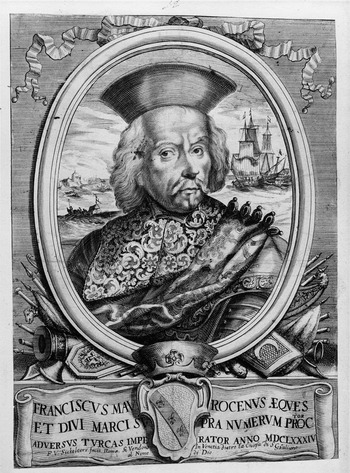
The capacity of inexpensive printed portraits to incarnate military leaders whose image would otherwise remain unavailable to commoners explains much of their significance. Deploying the rhetoric of exemplarity, engraved portraits not only visualized the myth of aristocratic heroic virtue and dedication to government service, but also fabricated new military celebrities (Figure 15). When added to maps, such portraits significantly enhanced the power of cartographic storytelling because they connected the empire builders with the spatial outcomes of their expansionist campaigns. In so doing, these portraits became yet another means of experiencing Venetian colonialism through the likenesses of glamorous patricians who fashioned themselves as great military commanders in the battlefields and seas of the Levant.
P. van Sickeleers, Engraved portrait of Francesco Morosini (Venice, seventeenth century). Biblioteca del Museo Correr, Venice.

IV
This article has shown that exploring the visual archive produced during the colonial expansion of Venice at the end of the seventeenth century provides unique insights into the imperial dimensions of Venetian print culture and book history. Although the sample of images examined here is far from exhaustive, it nevertheless allows us to consider the key role of the military in shaping the way in which the empire came to be known in Venice. It also helps us to realize the degree to which warfare and colonial imagery affected visual print culture at the time, and the ways in which print media and government policy came together to promote the visual consumption of empire in the cultural life of Venice.
Certainly, the War of the Morea was part of a longer history of imperial/military print production in early modern Venice. Earlier episodes in the history of Venetian–Ottoman warfare, such as the battle of Lepanto and the War of Crete, had also triggered the production of cheap printed pictures to feed the widespread public interest in these events.Footnote 70 Lepanto, however, was a one-day event, whereas the ill-fated defence of Crete from 1645 to 1669 was marked by occasional Venetian successes. At any rate, the visual repertoire of those two conflicts is by no means comparable to the wealth and breadth of images printed during the War of the Morea. From the outbreak of the war in 1684 until its conclusion with the treaty of Carlowitz in 1699, the circulation of graphic news rose at an unprecedented rate, marking a qualitatively new stage in the development of visual media and the dissemination of commercialized military print.
Perhaps nothing elucidates more forcefully the intersections between politics, imperial cartography, and the book trade – a point that is crucial for understanding the motivations and intentions behind printed images – than the state support of Coronelli's cartographic workshop at the Frari. Coronelli prided himself on bringing together skilful craftsmen from France, Holland, England, and Germany as well as the best engravers from Rome to train local artisans and produce a vast number of images which formed, as he put it, ‘a precious perpetual deposit to the decorum and service’ of Venice.Footnote 71 As he declared, his aim was to ‘awaken the spirits of [his] fellow citizens and subjects’ in the Republic so that they could offer her their ‘generous services’. Yet these engravers arrived in the lagoon city not as a result of the free operation of market forces, but in response to direct government intervention. The Republic provided an institutional framework and financial backing to Coronelli's projects by appointing him as its official cosmographer and by encouraging his recruitment efforts so that the hitherto ‘almost totally abandoned’ art of engraving would become again ‘very useful to public service’ and capable of promoting ‘public decorum’.Footnote 72 The government funding of Coronelli's image-making activities explicitly suggests that the state actively engaged in a process of sponsoring visual propaganda in support of the war both to enhance its reputation and to influence public opinion.
Making army drawings widely visible, however, ran parallel to hiding others from public view. Military visual documents were first and foremost treated as top state secrets and their publication was subject to a strict regime of controlled visibility. ‘As with all printed material’, David Woodward notes, ‘map and print trades were under tight control.’Footnote 73 Although there was little in Venetian legislation about the licensing of prints, permission was required especially for images accompanied by text, since written legends could influence the signification of the image. The need for official authorization underlines the fact that maps were perceived as powerful visual secrets capable of impressing dangerous ideas on the minds of indiscriminate viewers. Occasionally, censorship went hand in hand with the practice of confiscation in the quest to limit viewing audiences. In 1699, the Inquisitori di Stato, for example, confiscated the copperplate and printed copies of a map designed by Giust'Emilio Alberghetti showing Dalmatia with the post-Carlowitz borders.Footnote 74 Similarly, after Coronelli's death in 1718, the Inquisitori ordered the compilation of the inventory of his workshop materials because it contained strategically sensitive documents, such as ‘important maps relating to public affairs of great envy, as well as various manuscripts and relazioni of different ambassadors’. Most of these were taken and transferred to the state archives, while the copper plates of the Republic's fortresses were rendered unusable and handed to the guardian of the Frari to be sold later at the price of metal.Footnote 75
Visibility and invisibility, however, were also constitutive of published images and illustrated books. As the critical history of cartography has shown, maps are not neutral depositories of geographical information but politicized artefacts which are produced within a certain context of power and knowledge relations and offer highly selective visions of space through simplifications, contradictions, exclusions, and silences.Footnote 76 Pictures, more generally, are not transparent windows on the world; they are embedded in institutional practices and articulate particular configurations of hegemonic discourses, ways of seeing, and artistic choices. The cultural agency of Venetian printed images, therefore, should not be reduced to their instrumental role as carriers of information. Prints offered readers the empire on paper, but their documentary realism performed a creative rather than a merely descriptive function. They made war and empire visible, but at the same time they celebrated territorial authority and justified colonial expansion. In showing sanitized images of the war which projected visions of a powerful conquering empire with a religious mission, they brought martial values to the centre stage of Venetian cultural life and elicited a composite emotional response that combined civic pride, pleasure, and imperial patriotism. In this regard, more than an instrument of Levant-mirroring, prints acted as a means of Levant-making and played an important part in the socio-cultural production of space that defined Venice's imperial geography.