In the seventeenth and eighteenth centuries, Spanish writers used the term El Cuartelejo to describe portions of the Great Plains northeast of the Rio Grande pueblos, where some Pueblo residents moved to escape Spanish colonial control (Bolton and Marshall Reference Bolton and Marshall1921:291; Dunn Reference Dunn1915:350; Gunnerson Reference Gunnerson1974; Gunnerson and Gunnerson Reference Gunnerson, Gunnerson, Basso and Opler1971:11; Hodge Reference Hodge1900:778). In the late nineteenth century, University of Kansas (KU) paleontologists excavated a seven-room masonry pueblo at the western Kansas site of 14SC1, Scott County Pueblo (Figure 1), located in ancestral Apache territory more than 480 km away from the northern Rio Grande pueblos, and identified the locality as El Cuartelejo (Martin Reference Martin1909; Williston and Martin Reference Williston and Martin1900; cf. Williston Reference Williston1899).
Map of the Central and Southern Great Plains with locations of localities mentioned in the text.

Untangling the Scott County Pueblo from historic accounts has been challenging ever since. Scholars often assume that the site dates to a roughly 70-year interval: the period between AD 1639 and 1706, when residents from Taos and Picuris pueblos reportedly occupied El Cuartelejo (e.g., Martin Reference Martin1909; Wedel Reference Wedel, Reed and King1950; Williston Reference Williston1899; Williston and Martin Reference Williston and Martin1900; Witty Reference Witty1971, Reference Witty1983). Scholars also assume that at least some people at 14SC1 originally came from the northern Rio Grande region (e.g., Opler Reference Opler, Wyckoff and Hofman1982:143, Reference Opler and Ortiz1983; Wedel Reference Wedel, Reed and King1950:107, Reference Wedel1959:468; Witty Reference Witty1971, Reference Witty1983). Dissenters argue that interaction, rather than migration, between the Plains and northern Rio Grande better accounts for the Puebloan material culture at the site (Gunnerson Reference Gunnerson1960, Reference Gunnerson1987) or that the site represents a community of unidentified Great Plains people (Gulley Reference Gulley2000). Gunnerson (Reference Gunnerson2006:626) later took an unusual position by rejecting any association of the 14SC1 pueblo with Spanish accounts, instead suggesting that it was an illegal Spanish trading post active between 1706 and 1719.
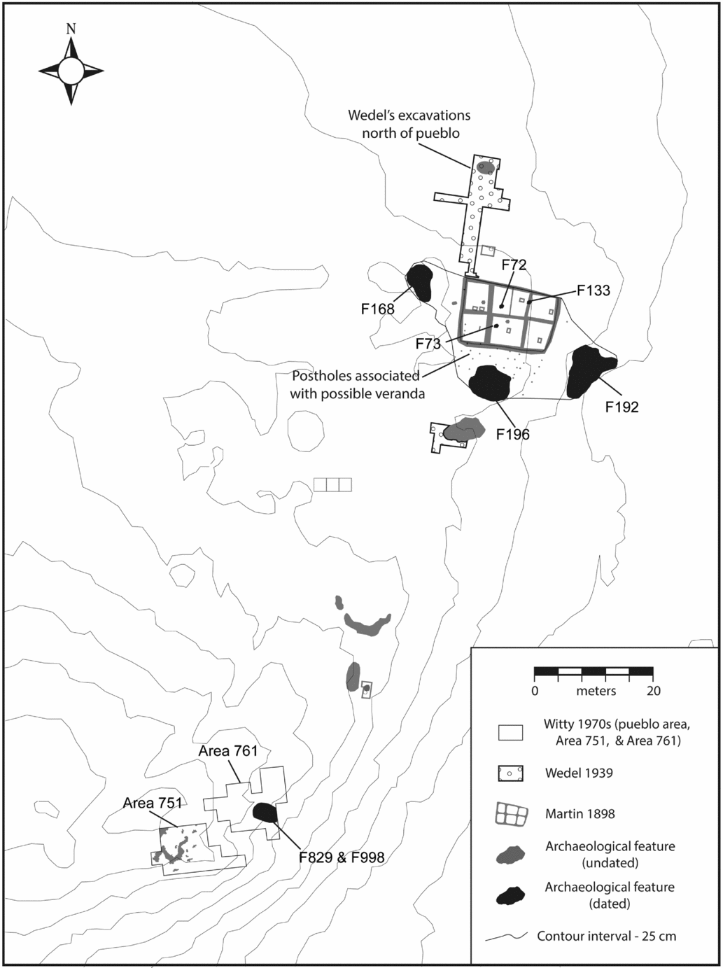
The interpretations of 14SC1 have evolved over time with new excavations and additional artifact data. The earliest excavations (Martin Reference Martin1909; Williston Reference Williston1899; Williston and Martin Reference Williston and Martin1900) uncovered little evidence for an ancestral Apache (Dismal River archaeological complex) presence and instead mostly identified Puebloan artifacts and features, including the masonry pueblo (Figure 2). Later excavators (e.g., Gunnerson Reference Gunnerson1987; Wedel Reference Wedel1959, Witty Reference Witty1971, Reference Witty1983) report minimal Puebloan artifacts and features compared with the abundance of Dismal River artifacts at the site (see Beck and Trabert Reference Beck and Trabert2014 for an overview of the site's excavation history). We have previously argued that Puebloan women, if not entire families, were incorporated into Dismal River communities at 14SC1 and nearby sites (Beck and Trabert Reference Beck and Trabert2014; Beck et al. Reference Beck, Trabert, Hill and Hill2016; McGrath, Beck, and Hill Reference McGrath, Beck and Hill2017; Trabert Reference Trabert2014, Reference Trabert2015, Reference Trabert, Hill and Cooley2017; Trabert, Hill, and Cooley Reference Trabert, Hill and Cooley2017).
Site map of 14SC1, Scott County Pueblo, with locations of prior excavations and all dated features used in this analysis identified. Undated features and prior excavations not considered in this analysis are presented in gray.

Our goal here is to describe the timing and nature of Puebloan occupation in western Kansas by analyzing the dates from the Puebloan and Dismal River components at 14SC1. In this article, we describe the association of Dismal River and northern Rio Grande material culture at 14SC1 and outline a chronology of occupation. We describe features created before the establishment of the pueblo, during the early construction and use of the pueblo, and during the period of abandonment, concluding that the occupation at 14SC1 is older than previously recognized. We use Bayesian analyses to test hypotheses that the site's dates are consistent with historic accounts of an early Taos migration (AD 1639–1662) or a later multipueblo migration (AD 1696–1706) to the Great Plains. We conclude that the pueblo was constructed between cal AD 1630 and 1660 and abandoned sometime between cal AD 1640 and 1690 and that ancestral Apache (Dismal River) people lived at the site just before and during the pueblo occupation. Given that the pueblo likely predates the Pueblo Revolt of AD 1680 and subsequent events (including an AD 1696 migration from the northern Rio Grande and Spanish trading in the early 1700s), it may represent the mid-seventeenth-century movement of people from Taos or a different, unrecorded movement of people from the northern Rio Grande region.
The Association of 14SC1 with “El Cuartelejo” (AD 1639–1706)
The earliest recorded movement of Rio Grande residents to “El Cuartelejo” involved people from Taos around AD 1639, according to the Spanish Franciscan missionary-explorer Escalante writing more than a hundred years later:
In the middle of the last century some families of Christian Indians of the nation and pueblo of Taos rebelled, withdrew to the buffalo plains and fortified themselves at a place which afterwards on this account was called El Cuartelejo [Silvestre Velez del Escalante, letter, April 2, 1778, in Twitchell Reference Twitchell1914:279–280; see Gunnerson Reference Gunnerson1987:106].
Shortly thereafter, probably in AD 1642 or 1643, Juan de Archuleta returned some of the Taos Pueblo migrants to New Mexico (Twitchell Reference Twitchell1914). Governor Peñalosa led another expedition to El Cuartelejo in AD 1662, bringing back the remaining Taos residents who had been living with Plains Apache groups for roughly 22 years (Forbes Reference Forbes1960).
El Cuartelejo was a recorded destination again in AD 1696, in the aftermath of the AD 1680 Pueblo Revolt, the temporary expulsion of the Spanish from northernmost New Spain, and the subsequent Spanish return through negotiation and force (Liebmann Reference Liebmann2012; Wilcox Reference Wilcox2009). According to Diego de Vargas, people from the Picuris, Taos, and Tewa pueblos (including Santa Clara) fled toward the Plains as the Spanish military advanced into the northern Rio Grande region in late October 1696 (Forbes Reference Forbes1960:271). This event nearly emptied Picuris Pueblo, leaving only a few residents to encounter Juan de Ulibarrí a decade later and report that “their kinsmen . . . were now in captivity and oppressed by the barbarous heathen Apache tribes of the plains and Cuartelejo” (Thomas Reference Thomas1935:61). Following an expedition to the Plains, Ulibarrí returned 62 men, women, and children to Picuris in AD 1706 (Thomas Reference Thomas1935:74). The Spanish recorded no further Puebloan occupants in El Cuartelejo after 1706, although they described their encounters with other native groups in the area (primarily various Apache groups but also occasionally Pawnee, Ute, and Comanche people; Thomas Reference Thomas1935).
The El Cuartelejo in these documents is interpreted by modern historians not as a specific place but as a larger region encompassing parts of Nebraska, Kansas, Colorado, and New Mexico (e.g., Gunnerson Reference Gunnerson1974). None of the Spanish accounts unquestionably refers to the archaeological site 14SC1 in Scott County, Kansas. In fact, the Ulibarrí expedition was probably in eastern Colorado (e.g., Espinosa Reference Espinosa1936:179; Thomas Reference Thomas1935:271) or eastern New Mexico (Gunnerson Reference Gunnerson1974:108; Montgomery Reference Montgomery2015:147). Nevertheless, the documentary record has been the primary lens through which the age and significance of 14SC1 are viewed. As 14SC1 contained the only known pueblo in this part of the Great Plains, sufficiently distant from Santa Fe as described in the documents, the original excavators felt “almost certain” that the site “corresponds to Cuartelejo” (Williston and Martin Reference Williston and Martin1900:127; see similar comments in Wedel Reference Wedel1959:468).
There is convincing archaeological evidence at 14SC1 for a northern Rio Grande Puebloan presence along with an ancestral Apache presence. The original KU excavations at 14SC1 (Martin Reference Martin1909; Williston Reference Williston1899; Williston and Martin Reference Williston and Martin1900) established the similarity of the seven-room masonry structure to pueblos in the northern US Southwest, including well-plastered walls and floors, ladders providing access to each room through the roof, the presence of square stone-lined hearths, and large trough manos and metates (Martin Reference Martin1909). These early excavations also recovered northern Rio Grande ceramics as well as Rio Grande–style decorated clay pipes (Beck and Trabert Reference Beck and Trabert2014; Johnson Reference Johnson1957).
Williston and Martin's selective collection and curation practices have undoubtedly skewed the proportion of different artifact types in the KU collection. Subsequent excavations revealed that, in total, Puebloan artifacts make up a minority of the objects recovered from the site. Less than 1% of the sherds recovered from the 1930s Smithsonian excavations (Wedel Reference Wedel1940, Reference Wedel1959) and the 1970s Kansas Historical Society excavations (Witty Reference Witty1971, Reference Witty1975, Reference Witty1983) represent vessels manufactured in the northern Rio Grande (Beck and Trabert Reference Beck and Trabert2014; Beck et al. Reference Beck, Trabert, Hill and Hill2016). Characteristic Dismal River ceramics and stone and bone tool forms dominate the archaeological collection from 14SC1 (Beck and Trabert Reference Beck and Trabert2014; Trabert Reference Trabert2014, Reference Trabert2015), suggesting that people who were probably ancestral Apache also occupied the site (Brunswig Reference Brunswig, Brunswig, Bradley and Chandler1995; Champe Reference Champe1949; Gunnerson Reference Gunnerson1987; Scheiber Reference Scheiber, Hoard and Banks2006; Wedel Reference Wedel1959).
Our own ceramic analyses suggest that “at least some Puebloan women occupied 14SC1, reproducing Puebloan vessel forms and attempting to prepare and serve food in culturally appropriate ways” (Beck and Trabert Reference Beck and Trabert2014:316). They made and used bowls in higher frequencies than usual for the region, and they made a local version of Tewa Red known as Ledbetter Red (Beck et al. Reference Beck, Trabert, Hill and Hill2016; McGrath, Beck, and Hill Reference McGrath, Beck and Hill2017). Puebloan women or families joined an established Dismal River community and were integrated into it, so that their female descendants at later nearby sites still produced some Ledbetter Red while otherwise using Dismal River material culture (Beck et al. Reference Beck, Trabert, Hill and Hill2016; Trabert Reference Trabert, Hill and Cooley2017; Trabert, Hill, and Cooley Reference Trabert, Hill and Cooley2017).
It is certainly possible that people from the northern Southwest arrived at Scott County Pueblo during one or both of the historically documented flights to the Great Plains in the AD 1639–1706 window. It is also possible that they arrived through similar but unrecorded movements of people from the northern Rio Grande region to the Great Plains, whether during this time or another. Residents of Rio Grande pueblos moved to neighboring regions throughout the colonial period to avoid Spanish control and violence, often joining native groups with different languages and settlement patterns (Dozier Reference Dozier1954; Forbes Reference Forbes1960; Kulisheck Reference Kulisheck2003, Reference Kulisheck, Scheiber and Mitchell2010; Preucel Reference Preucel2002; Spicer Reference Spicer1962; Spielmann et al. Reference Bronk Ramsey2009). Alternately, individual Puebloan women may have arrived on the Plains as wives or captives (Brooks Reference Brooks2011; Cameron Reference Cameron2013; Eiselt Reference Eiselt2012; Habicht-Mauche Reference Habicht-Mauche and Hegmon2000, Reference Habicht-Mauche and Cameron2008; Ortman and Cameron Reference Ortman, Cameron, Nelson and Strawhacker2011), in episodes that did not draw the attention of Spanish chroniclers.
Using chronometric data, we can at least evaluate how the construction, use, and abandonment of the Scott County Pueblo relate temporally to the historically documented El Cuartelejo migration windows. In the following analysis and discussion, we develop a Bayesian analytical framework for evaluating different models of the pueblo's use history by constraining the associated radiocarbon dates by their respective stratigraphic data, and we test a series of null hypotheses (based on the historic accounts) that the Puebloan occupation of 14SC1 occurred within the AD 1639–1706 window.
Assessing Occupation History: Sampling and Stratigraphy
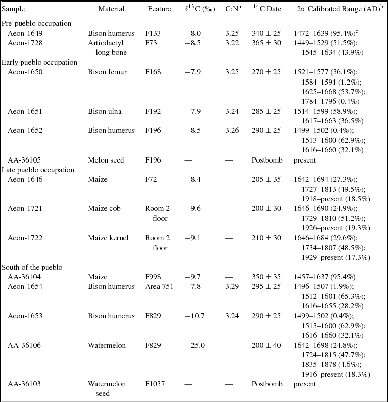
The 14SC1 chronology presented here is based on 14 accelerator mass spectrometry dates (Table 1) analyzed at the University of Arizona laboratory and Aeon Laboratory, LLC. Four of these dates were previously submitted and discussed by Adair (Reference Adair and Minnis2003; Beck and Trabert Reference Beck and Trabert2014:321; Hoard and Banks Reference Hoard and Banks2006:314; Scheiber Reference Scheiber, Hoard and Banks2006:146), although two (one on watermelon and one on melon) produced ages categorized as “postbomb” and are not used in this study. We used the OxCal 4.3 program (Bronk Ramsey Reference Bronk Ramsey2009) with the IntCal 13 calibration curve (Reimer et al. Reference Reimer, Bard, Bayliss, Warren Beck, Blackwell, Ramsey, Buck, Cheng, Lawrence Edwards, Friedrich, Grootes, Guilderson, Haflidason, Hajdas, Hatté, Heaton, Hoffmann, Hogg, Hughen, Felix Kaiser, Kromer, Manning, Niu, Reimer, Richards, Marian Scott, Southon, Staff, Turney and van der Plicht2013) to calibrate the 12 usable dates. Calibrated dates are reported as two-sigma ranges with end points rounded to the nearest decade. We also used OxCal's Bayesian analytical framework to evaluate different models of the pueblo's use history by constraining the associated radiocarbon dates by their respective stratigraphic data.
Accelerator Mass Spectrometry Radiocarbon Dates from Scott County Pueblo (14SC1).

a C:N = carbon-to-nitrogen ratio.
b Calibrated with the OxCal 4.3 program (Bronk Ramsey Reference Bronk Ramsey2009; Bronk Ramsey and Lee Reference Bronk Ramsey and Lee2013) using the IntCal 13 calibration dataset (Reimer et al. Reference Reimer, Bard, Bayliss, Warren Beck, Blackwell, Ramsey, Buck, Cheng, Lawrence Edwards, Friedrich, Grootes, Guilderson, Haflidason, Hajdas, Hatté, Heaton, Hoffmann, Hogg, Hughen, Felix Kaiser, Kromer, Manning, Niu, Reimer, Richards, Marian Scott, Southon, Staff, Turney and van der Plicht2013).
c The percentage value in parentheses = (relative area under the calibration curve)
Although we have a relatively small dataset of 12 radiocarbon dates, we take advantage of OxCal's ability to incorporate nonquantitative archaeological data into models of site chronology, thereby expanding the pool of available temporal information. We use explicit archaeological hypotheses about site chronology (priors) to order, group, and constrain the available chronometric data within a Bayesian statistical framework (Bayliss Reference Bayliss2009; Bronk Ramsey Reference Bronk Ramsey2009). An agreement index (A) is calculated for the model that indicates how well the results from the model, and the model itself, fit with the available data. Empirical comparisons with χ2 tests show that a threshold agreement index of A = 60 is roughly analogous to the 0.05 significance level of a χ2 test (Bronk Ramsey Reference Bronk Ramsey1995:428), and models that produce A < 60 are a poor fit with the available data. In these cases, the assumptions and interpretations used to structure the model need to be reevaluated to determine the problem. Models that produce an A ≥ 60 are not necessarily “true.” Instead, they simply reflect valid fits between archaeological assumptions and the available chronometric data. It is possible to generate multiple valid models for a single archaeological dataset using varying input parameters to structure the data.
An additional benefit of OxCal is its ability to estimate date ranges for events that are difficult to date directly, such as construction and abandonment events, which are behavioral events that may not have associated datable materials (Bayliss Reference Bayliss2009; Cullerton, Prufer, and Kennett Reference Cullerton, Prufer and Kennett2012). In this case, the software uses the spread of available chronometric data combined with the archaeological priors to calculate posterior density estimates for specific parameters of the model. Typically, start and end events are modeled as boundaries that bracket the directly dated events within the model.
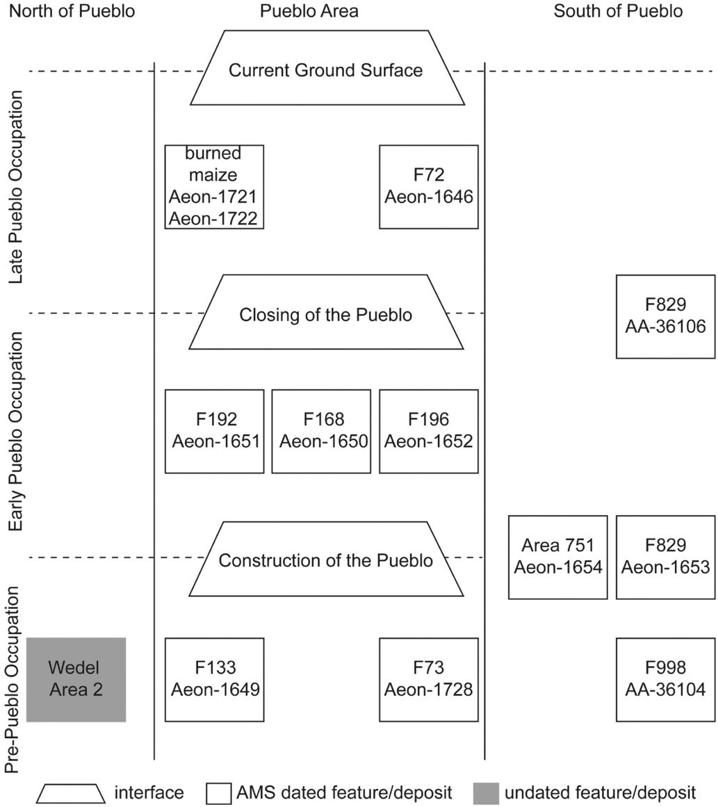
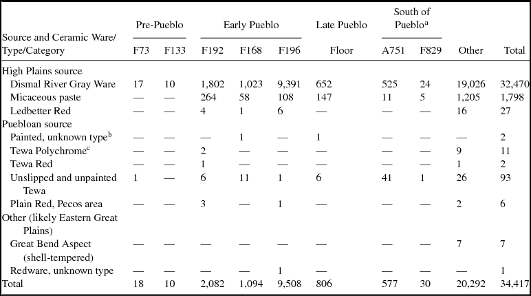
Of the 12 calibrated dates, eight are associated with pueblo features that fall into one of three time periods, based on stratigraphic evidence (Figure 3): (1) before the construction of the pueblo (F133 and F73), (2) pueblo construction or early use (F127/192, F168, and F196), or (3) abandonment of the pueblo (F72 and burned floor). The remaining four calibrated dates were obtained from materials recovered from extramural features (F998 and F829) located roughly 80 m south of the pueblo. Although the southern features are not directly associated with the pueblo, they are important for understanding the site's occupation history, particularly pertaining to the temporal relationship between different social groups at the site. Below we describe the dated features and our justifications for selecting them, and we summarize the ceramics recovered from these contexts in Tables 2 and 3.
Idealized stratigraphic relationship among features discussed in this analysis. The stratigraphic relationship between the features south of the pueblo and the episodes of pueblo construction and closing are estimated. AMS = accelerator mass spectrometry.

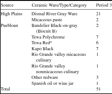
Count of Identified Ceramics from the University of Kansas Collection from the Pueblo Fill by Likely Source Area.

a Includes some sherds with incomplete slipping.
Count of Identified Ceramics from the Kansas State Historical Society Collection from the Pueblo Fill by Likely Source Area.

a None recovered from F998.
b Both rims with traces of black paint but no visible slip; see Beck et al. Reference Beck, Trabert, Hill and Hill2016:151.
c All body sherds consistent with Tewa Polychrome (seven polychrome; four similar but lacking red slip, white slip, or black paint).
Pre-Pueblo Occupation (F133 and F73)
Witty's (Reference Witty1983) excavations were the first to recognize an occupation at 14SC1 predating the pueblo, identifying a Dismal River roasting pit underneath one of the pueblo walls. Our reanalysis of Witty's excavations suggests that at least two Dismal River features predate the pueblo, appearing stratigraphically below it.
The Dismal River feature identified by Witty (Reference Witty1983) is F133, a circular, straight-sided roasting pit. The pit was approximately 67 cm in diameter and 24 cm deep and had oxidized edges. Feature fill was dark sediment mixed with burned earth and charcoal, along with faunal bones, chipped-stone debitage and tools, and 10 very small (<5 cm2) Dismal River Gray Ware body sherds. Witty considered the pit “similar to the roasting pits that are associated with [other] Dismal River sites” (Reference Witty1983:105). The top of this feature is located at or slightly below the level of the pueblo floor and directly beneath the stone wall separating rooms 6 and 7 of the pueblo (Witty Reference Witty1983:105).
At the time F133 was excavated, all rocks from the pueblo wall had been removed by earlier excavations, local scavenging of rock for building material, and erosion. Even so, we are confident that this feature was stratigraphically below the pueblo for several reasons. First, F133 appears below the wall, both in Witty's reconstruction of the pueblo and in our own georeferenced geographic information system maps (which overlay Williston and Martin's and Witty's excavations). Second, the sediments immediately surrounding the roasting pit were sterile and similar in appearance to unmodified soil throughout the site, while the sediments in adjacent pueblo rooms contained numerous artifacts and were visually and texturally distinct. We agree with Witty that “this pit predated the construction of the pueblo and would give indication that a Dismal River component was at this location prior to the construction of the pueblo” (Reference Witty1983:105). We selected an unburned bison humerus from the fill of this feature for radiocarbon dating.
Witty's excavations also identified a second roasting pit (F73) in the northwestern corner of Room 2. F73 is a circular bell-shaped pit, similar in size to F133. This pit had a clear oxidation ring along its northern and western edges and was 67 to 79 cm in diameter and ~40 cm deep. Its fill contained charcoal and burned earth, along with burned and unburned bones, various pieces of chipped-stone debitage, 17 Dismal River Gray Ware rim and body sherds, and an unslipped and unpainted Tewa Buff body sherd.
Although Witty did not identify F73 as predating the pueblo, our reanalysis indicates that this feature was located beneath a raised adobe bench along the walls of Room 2. Williston and Martin (Reference Williston and Martin1900:129) describe this bench as varying in width from 30 to 130 cm and elevated above the floor about 25 cm. The walls, bench, and floor of this room were well plastered. Floor artifacts in this room included a broken metal ax, a stone maul, 10 Dismal River Gray Ware sherds, arrow points, and scrapers; scattered across the floor were various burned bones and corn kernels. According to Witty's (Reference Witty1970) field notes, remnants of the Room 2 floor are immediately south of the F73 pit and may partially cut into it. An unburned artiodactyl long bone recovered from the pit fill was dated.
Both F73 and F133 are in a similar stratigraphic position to features excavated immediately north of the pueblo. In 1939, Wedel (Reference Wedel1940, Reference Wedel1959) encountered a series of hearths and burned areas buried approximately 45 to 50 cm below the ground surface north of the pueblo (Area 2). He recovered 2,300 artifacts, including Dismal River Gray Ware ceramics, chipped stone, bone, 26 pipe fragments, 8 obsidian artifacts, and 3 Olivella beads. Based on Wedel's profile diagrams, the majority of the archaeological deposits in Area 2 are located below the level of the pueblo floor.
Early Pueblo Occupation (F168, F192, and F196)
Only a few of the architectural components of the pueblo as originally excavated in the 1890s (six stone-lined hearths, seven short wall segments, and several fragments of plaster) survived to the present, complicating efforts to determine its precise age. Williston and Martin (Reference Williston and Martin1900; Martin Reference Martin1909) reported well-preserved and -plastered walls, a number of preserved posts used as supports for ladders, and preserved portions of the roof beams. Unfortunately, it appears that none of the post or beam material was collected, and none was therefore available for dating. However, three large trash-filled borrow pits immediately outside the pueblo represent construction and early use, and materials recovered from these pits were dated as part of this study.
The borrow pits were identified but not investigated during the first excavation of the site. Martin stated that “by the side of the building there are two large hollowed out places, which had probably been used for the puddling and mixing of the adobe employed in the construction of the building” (Reference Martin1909:13). In 1970, when Witty undertook detailed excavation of the area immediately outside the pueblo, he (Reference Witty1983) defined not two but three large borrow pits, located at the northwest corner (F168), southern edge (F196), and southeast corner (F192) of the pueblo and placed within 3–5 m of the walls.
F168, F192, and F196 were very large excavated pits (6.5 × 4.1 m, 8.7 × 8.5 m, and 7.2 × 5.7 m, respectively), irregular in outline with uneven floors and roughly 0.5–0.6 m deep. In form, they appear as large basins, with edges generally much higher than the center.
It is not clear how (or whether) the open basins were used while empty. We assume that given the potential hazards of these large depressions, residents were motivated to fill them relatively quickly. Portions of the base of F168 showed some oxidation, although the purpose or cause of fires here is unknown. Three postholes appeared at the immediate northern edge of F196, but they appear to be related to a larger group of 29 postholes (many of which are bone-wedged) rather than to use of the basin. The posthole group is interpreted as a remnant of a veranda, or a roofed-over, open-sided work area that ran across the southern wall of the pueblo and extended approximately 4.5 m to the south (Witty Reference Witty1975:2, Reference Witty1983:105).
After providing adobe and plastering materials for pueblo construction, these pits served as trash middens. Tens of thousands of artifacts were recovered from these three borrow pits. The fill consisted of soft soil with abundant ceramics, bone fragments, chipped-stone debitage and tools, charcoal, adobe pieces, mussel shell fragments, burned earth, and charred corncobs. The debris here includes some obsidian, Olivella shell, and decorated pipes. Although there is no obvious stratigraphy within the feature fill, some of the ash concentrations are thought to represent individual dumping episodes of debris from the pueblo room hearths because of the concentrated piling of the ash in F168 (Witty Reference Witty1970). Bison elements recovered from the fill of each of the three borrow pits were selected for radiocarbon dating and provide dates related to the pueblo occupation.
Late Pueblo Occupation (Burned Floor and F72)
The pueblo was catastrophically burned, ending its occupation. The initial excavators report ample evidence of the fire: “The adobe is burned, charcoal is thickly scattered everywhere; the stone and bone implements also all show evidence of fire” (Martin Reference Martin1909:15). The pueblo floor was “covered with a darker humus of decayed organic matter, and containing numerous fragments of charred corn and corncobs” (Williston Reference Williston1899:110). The amount of charred corn was substantial “in every room except VII, in some places four or five inches deep” (Williston and Martin Reference Williston and Martin1900:128). In one room alone (room 5), Williston and Martin (Reference Williston and Martin1900) estimated four or five bushels of maize in storage along just one wall.
We dated the abandonment of the pueblo using Martin's sample of charred and fused kernels and a cob fragment collected from the floor of Room 2. Both were drawn from the maize samples collected during the initial excavation, but unfortunately, we lack more precise provenience data than room designation.
An additional sample of corn was dated from F72, a small (67 × 54 cm) circular pit with straight sides in room 5. The pit contained dark soil, several pieces of burned earth, and some corn kernels. Unfortunately, the excavators identified rodent activity at the base of this feature, in the same area where the maize kernels were recovered. It is therefore possible that these kernels were among the burned corn kernels on the floor of the pueblo but were subsequently moved by rodent burrowing.
Extramural Features South of the Pueblo (F998, F829, and A751)
To round out our chronometric study, we included three radiocarbon dates obtained from two extramural features located in Witty's A761 excavation areas and a single date from Witty's A751, approximately 80 m south of the pueblo ruin. Two of these dates were previously reported (Adair Reference Adair and Minnis2003), and two were obtained through this study.
The earliest of the southern features (F998) is a straight-sided pit, 51 cm in diameter and 44 cm deep with a flat floor. It lies at the base of the cultural deposits in this portion of the site and was cut into the sterile light-colored silty soils that underlie the entire site. The top of the feature was located 60 cm below the ground surface and was immediately below deposits of a large trash midden (F829) covering this portion of the site. A previously reported date was obtained on a sample of maize recovered from the fill of this feature (Adair Reference Adair and Minnis2003).
We obtained additional dates from the overlying trash midden, F829. This feature is a large 1.1 m deep basin extending across portions of six excavation units and measuring approximately 4.2 × 2 m. The fill consists of dark organic-rich sediments mixed with a dense concentration of ceramics, chipped-stone tools, faunal remains (including articulated limb and spinal units), burned adobe, and charcoal. Toward the southwestern corner of the basin in Unit 919, excavators identified a series of ash and charcoal lenses that demarcated the initial filling of the basin. F829 cuts into a largely sterile silty clay stratum (Zone 5a) recognized across much of the 1976 excavation area. A previous date was obtained for this feature from watermelon seed recovered from the fill. We obtained a second date from a bison humerus recovered from the same feature fill. The final radiocarbon date came from an unburned bison humerus from the A751 excavation area, which consists of a relatively dispersed artifact concentration located adjacent to the A761 excavation area and positioned in a similar stratigraphic position as F829.
Hypothesis Testing
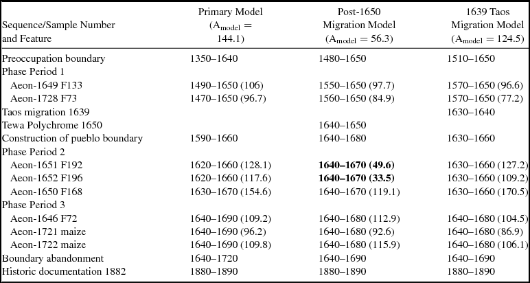
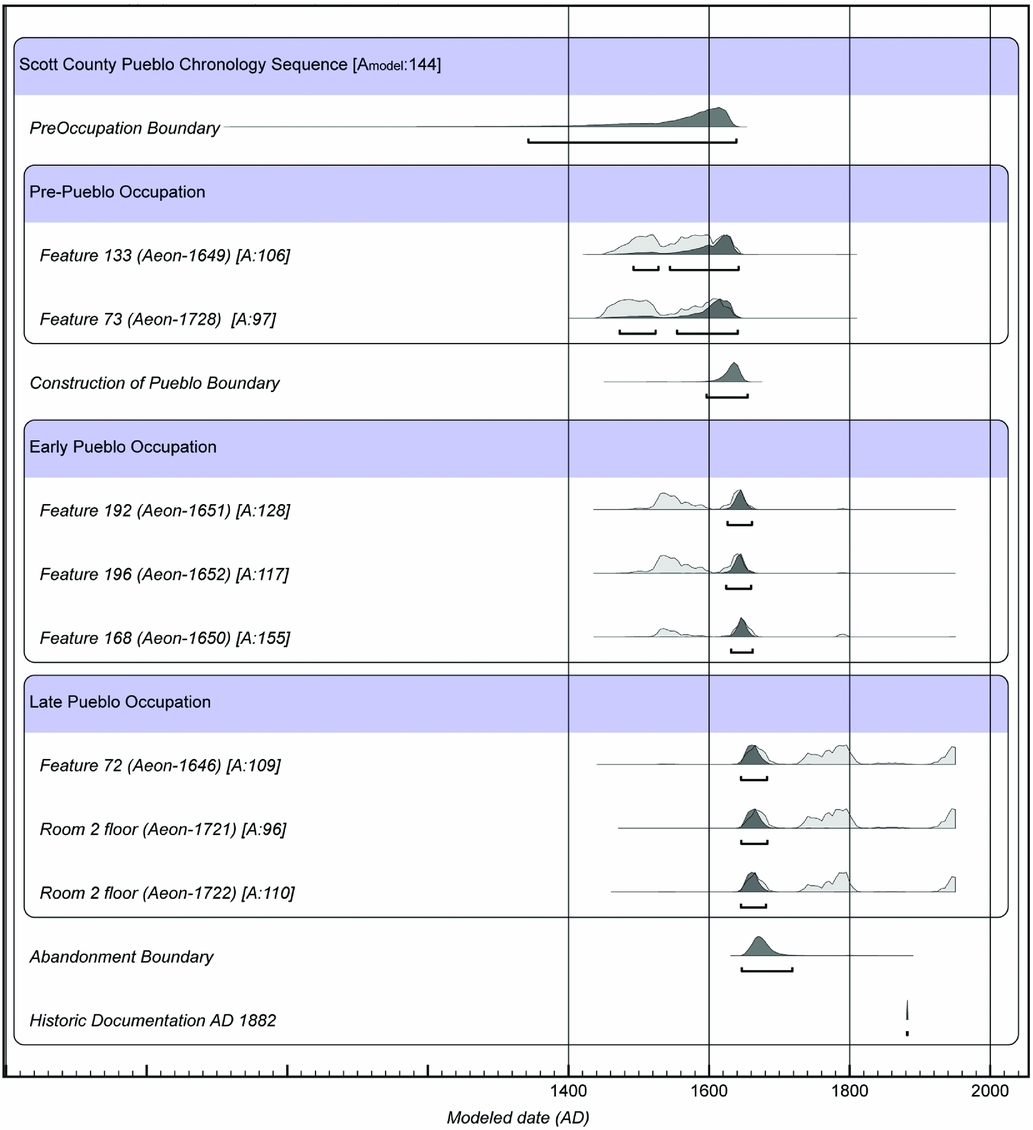
In this section, we evaluate three models of site chronology for the pueblo area: one primary model and two alternative models (Table 4). The primary model (Figure 4) is organized by the three periods of site use previously discussed: pre-pueblo activities, postconstruction pueblo use, and postabandonment. Boundaries were placed between these periods to reflect the actual construction and abandonment of the pueblo. The preconstruction dates were grouped together in a phase (treated as an unordered group of events in OxCal), rather than placed sequentially, because we had no a priori information about their relationship to each other. The dates relating to the occupation of the pueblo, however, were divided into two sequential phases based on our interpretation of activities at the pueblo. The dates recovered from the midden features, interpreted as relating to the general occupation of the pueblo, were grouped together in the “Early Pueblo Occupation” phase. The dates recovered from burned room contexts, however, were interpreted as reflecting activities associated with the abandonment of the pueblo; we grouped these dates together in the “Late Pueblo Occupation” phase, placed later in the model sequence. We had no radiocarbon dates that could be related to postabandonment activities at the site. We used the earliest documented visit to the abandoned pueblo in AD 1882 (Williston Reference Williston1899:113) to cap the end of the sequence, thereby mitigating the postbomb pull of the calibration curve on young radiocarbon samples.
Age Ranges for Three Bayesian Models for the Scott County Pueblo Sequence.

Note: Dates reported in cal AD format at 95.4% probability. Modeled ages rounded to the nearest decade. Agreement indexes (A) appear in parentheses. Date ranges with agreement indexes less than 60 appear in boldface.
Bayesian Model 1 for radiocarbon dates from 14SC1 organized by the three periods of site use: pre-pueblo activities, postconstruction pueblo use, and postabandonment. Bars below probability distributions indicate 95.4% (2σ) probability ranged after the application of the Bayesian statistical analysis. Agreement indexes for each radiocarbon date are indicated as [A:#]. OxCal v. 4.3.2 © Bronk Ramsey 2017; r:5 IntCal 13 atmospheric curve (Reimer et al. Reference Reimer, Bard, Bayliss, Warren Beck, Blackwell, Ramsey, Buck, Cheng, Lawrence Edwards, Friedrich, Grootes, Guilderson, Haflidason, Hajdas, Hatté, Heaton, Hoffmann, Hogg, Hughen, Felix Kaiser, Kromer, Manning, Niu, Reimer, Richards, Marian Scott, Southon, Staff, Turney and van der Plicht2013). (Color online)

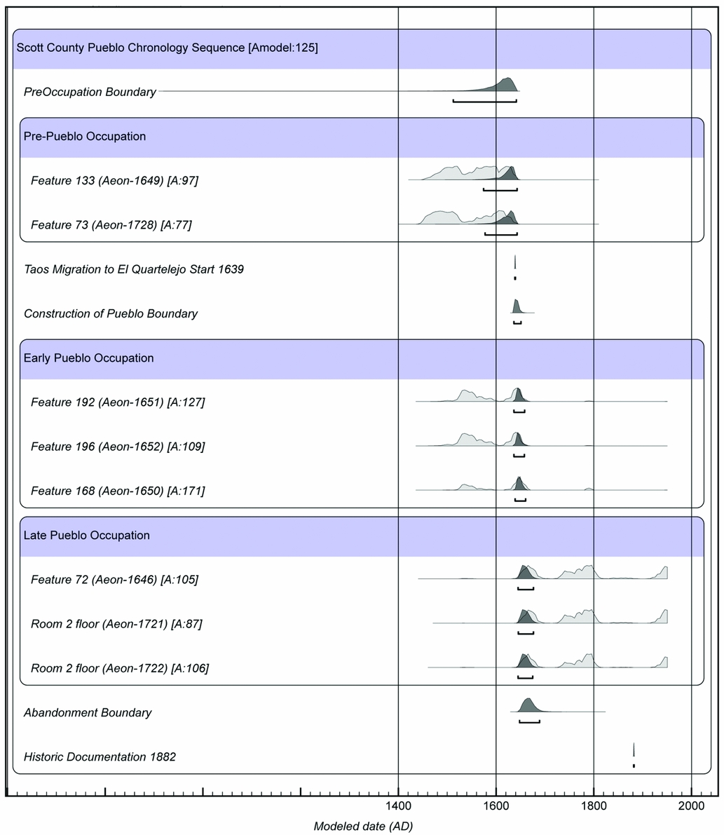
Overall, this model agreed very well with the available data from the site (Amodel = 144.1) and provides a good working interpretation of the pueblo's chronology. From this model, we estimated that the pueblo was constructed cal AD 1590–1660 and abandoned cal AD 1640–1720. While not particularly precise, given the likely brevity of the pueblo's use-life, this chronology serves as a good starting point in understanding the timing of events at the pueblo.
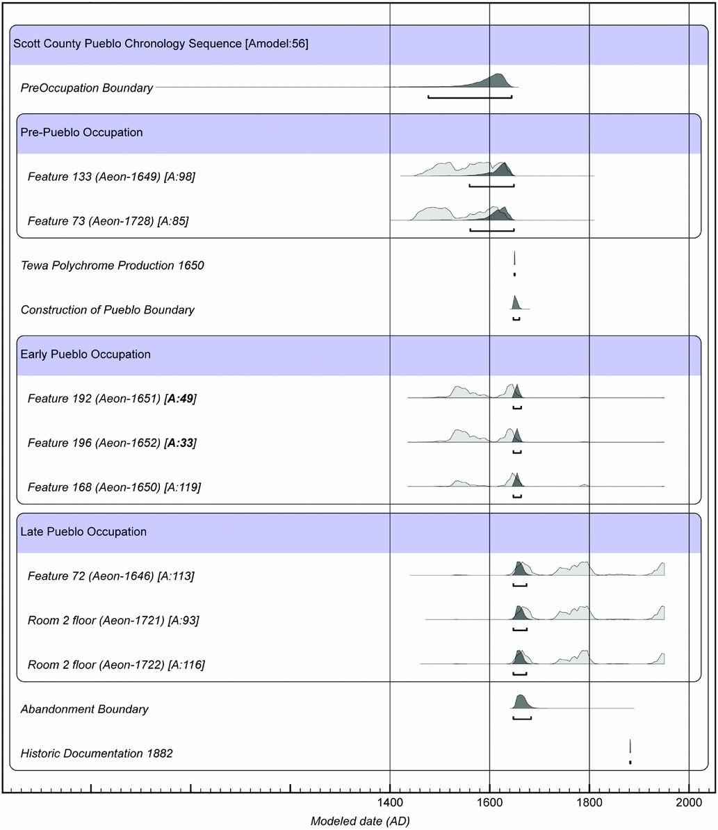
The initial model did not incorporate temporal information from dated ceramic types, given the very small number of dated ceramics with secure provenience information. Dated types, as discussed further below, include Bandelier Black-on-gray (AD 1400–1550) of unknown provenience, unpainted types (e.g., Tewa Red, Kapo Black, Ledbetter Red [Beck and Trabert Reference Beck and Trabert2014; Beck et al. Reference Beck, Trabert, Hill and Hill2016]) postdating AD 1600, and Tewa Polychrome (AD 1650–1750 [Bower and Snow Reference Bower, Snow, Scott Baldridge, Dickerson, Riecker and Zidek1984; Snow Reference Snow and Schroeder1982; Wilson Reference Wilson2011]). Tewa Polychrome, in particular, was recovered from known contexts within the pueblo, and we speculated that the people who built the pueblo might have brought Tewa Polychrome to the site. We therefore developed a second model of site chronology that forced the construction of the pueblo to postdate AD 1650, as an early date for the production of Tewa Polychrome (Figure 5). This model, however, was not a good fit to the available dataset (Amodel = 56.3).
Bayesian Model 2 for radiocarbon dates from 14SC1 that forces the construction of the pueblo to postdate the appearance of Tewa Polychrome ceramics (AD 1650). Bars below probability distributions indicate 95.4% (2σ) probability ranged after the application of the Bayesian statistical analysis. Agreement indexes for each radiocarbon date indicated as [A:#]. OxCal v. 4.3.2 © Bronk Ramsey 2017; r:5 IntCal 13 atmospheric curve (Reimer et al. 2013). (Color online)

We constructed a third model that forced the construction of the pueblo to postdate the AD 1639 start of the recorded Taos migration to El Cuartelejo (Figure 6). Surprisingly, this model was a good fit with the available dataset (Amodel = 124.5). The addition of the AD 1639 prior to the model forced the pueblo construction estimate to fall to cal AD 1630–1660 with decadal rounding. The abandonment estimate was calculated as cal AD 1640–1690. This model is by no means proof of a connection between the 14SC1 pueblo and the mid-seventeenth-century migration from Taos, but it leaves open the possibility of this connection.
Bayesian Model 3 for radiocarbon dates from 14SC1 that forces the construction of the pueblo to postdate the historic accounts of Taos migration to the Plains (AD 1639). Bars below probability distributions indicate 95.4% (2σ) probability ranged after the application of the Bayesian statistical analysis. Agreement indexes for each radiocarbon date indicated as [A:#]. OxCal v. 4.3.2 © Bronk Ramsey 2017; r:5 IntCal 13 atmospheric curve (Reimer et al. Reference Reimer, Bard, Bayliss, Warren Beck, Blackwell, Ramsey, Buck, Cheng, Lawrence Edwards, Friedrich, Grootes, Guilderson, Haflidason, Hajdas, Hatté, Heaton, Hoffmann, Hogg, Hughen, Felix Kaiser, Kromer, Manning, Niu, Reimer, Richards, Marian Scott, Southon, Staff, Turney and van der Plicht2013). (Color online)

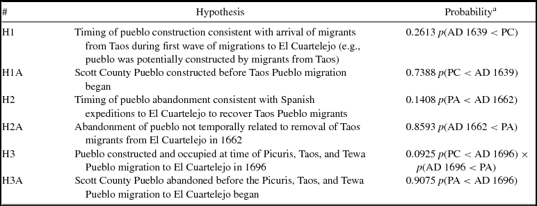
Finally, we used one more aspect of OxCal modeling—the ability to query the model and perform calculations on the model results. Specifically, we used the Order function, which allows the user to ascertain the probability that specific events occurred before or after each other in a series (Table 5). For this study, we used the Order function to test a series of hypotheses about the temporal relationship between the start and end dates of the Taos migration (AD 1639–1662) and the Picuris migration (AD 1696–1706) and the modeled construction and abandonment boundaries calculated from Model 1 of this study. The results from these tests strongly suggest that the Scott County Pueblo was occupied during the time of the recorded Taos migration (AD 1639–1662) but abandoned before AD 1696.
Chronological Hypotheses about the Temporal Relationship between the Construction and Abandonment of the Scott County Pueblo and Documented Periods of Migration.

Note: The posterior density estimates for pueblo construction and abandonment used in the hypothesis testing were calculated from Model 1 of this study.
a PC = pueblo construction; PA = pueblo abandonment.
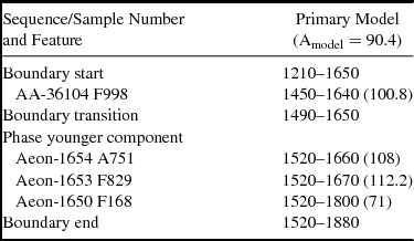
Because the feature south of the pueblo cannot be precisely associated with the pueblo deposits, we created a separate Bayesian model for these features, and we did not attempt to correlate this sequence with the pueblo deposit (Table 6). We organized our model so that the stratigraphically deeper F998 is separate from the other dates, which are grouped as a single phase. The resultant model is acceptable (Amodel = 90.4) but not very precise. F998 dates to cal AD 1450–1640, while the other three dates in this area range from cal AD 1520 to 1800. F998 predates F829. It probably predates the construction of the pueblo as well, although all the uncalibrated dates from the southern portion of the site (except for the later date from F829) are similar to the pre-pueblo dates from the northern part of the site. However, we cannot say for sure that these features reflect activities coeval with activities that underlie the pueblo or the earliest use of the pueblo.
Age Ranges for Three Bayesian Models for the Southern Features Sequence at Scott County Pueblo.

Note: Dates reported in cal AD format at 95.4% probability. Modeled ages rounded to the nearest decade. Agreement indexes (A) appear in parentheses.
Discussion
Initial occupation of 14SC1 by Dismal River people occurred sometime between cal AD 1470 and 1640, represented here by dated features F73, F133, and probably F998 south of the pueblo. The deposits from A751 and F829 may also reflect initial use of the site but could equally be associated with early use of the pueblo. The small ceramic sample from F73 and F133 (Table 3) is made up almost entirely of Dismal River Gray Ware and micaceous ceramics (at least some of which were produced on the High Plains near the Rocky Mountains [Trabert et al. Reference Trabert, Eiselt, Hill, Ferguson and Beck2016]). These early deposits contain neither painted northern Rio Grande types nor unpainted redware types postdating AD 1600 (see Beck et al. Reference Beck, Trabert, Hill and Hill2016). However, Tewa Buff sherds similar to ceramics recovered in larger numbers from contexts associated with the pueblo were recovered from F73, A751, and F829. Two sherds of Bandelier Black-on-gray, or Biscuit B (AD 1400–1550; Ellis Reference Ellis1964:34), were also recovered during the initial excavation of the pueblo (Johnson Reference Johnson1957). Although we lack precise provenience for these sherds, they may be associated with the pre-Puebloan occupation.
These dates indicate that the ancestral Apache occupation at 14SC1 predates the commonly accepted date range for Dismal River (AD 1675–1725) in the eastern portion of the Central Great Plains (Gunnerson Reference Gunnerson1960; Scheiber Reference Scheiber, Hoard and Banks2006:146; Schlesier Reference Schlesier1972). This is consistent with other work that dates the earliest presence of Apaches on the Central Plains to the cal AD 1400s or 1500s (Brunswig Reference Brunswig, Brunswig, Bradley and Chandler1995, Reference Brunswig and Seymour2012; Gilmore and Larmore Reference Gilmore, Larmore and Seymour2012; Kindig Reference Kindig and Cassells2000; O'Brien Reference O'Brien1984).
We suspect that features north of the pueblo excavated by Wedel (Reference Wedel1940, Reference Wedel1959), once suggested to be an outdoor cooking area associated with pueblo use (Wedel Reference Wedel1959:429–432), instead predate the pueblo and were created by Dismal River residents during the pre-pueblo occupation. Wedel was perplexed by the lack of Puebloan artifacts in this part of the site, and Beck and Trabert (Reference Beck and Trabert2014:329) observed a very low bowl-to-jar ratio (0.11:1.00) for ceramics here, similar to that in Dismal River sites. Items such as the eight obsidian artifacts and three Olivella beads from north of the pueblo, as well as the Bandelier Black-on-gray sherds noted above, suggest some exchange between Dismal River groups and Puebloan communities in this early period but are not sufficient evidence of Puebloan residents.
Our original OxCal model suggests that the pueblo was constructed between cal AD 1590 and 1660, although our third model forcing the construction of the pueblo to postdate AD 1639 suggests a shorter time interval: cal AD 1630–1660. The ceramics associated with the pueblo confirm its use after AD 1600 into the mid-seventeenth century, given the appearance of unpainted redware types postdating AD 1600 (Beck et al. Reference Beck, Trabert, Hill and Hill2016) and Tewa Polychrome (AD 1650–1750 [Bower and Snow Reference Bower, Snow, Scott Baldridge, Dickerson, Riecker and Zidek1984; Snow Reference Snow and Schroeder1982; Wilson Reference Wilson2011]). One sherd previously listed by Beck and Trabert (Reference Beck and Trabert2014:Table 4) as indeterminate Rio Grande Glaze Ware actually has no trace of glaze paint and is now thought to be Plain Red rather than Pecos Glaze Polychrome (Beck et al. Reference Beck, Trabert, Hill and Hill2016:155, Figure 2f). Unslipped and unpainted ceramics with ash- or tuff-tempered buff paste, similar to ceramics typed as Nambe Buff or Tewa Buff (Wilson Reference Wilson2011; see Beck et al. Reference Beck, Trabert, Hill and Hill2016), are also consistent with early or mid-seventeenth-century use. Ceramics recovered in the KU pueblo excavations with uncertain proveniences include northern Rio Grande ceramics such as Kapo Black and Rio Grande culinary ceramics as well as one Spanish colonial ceramic fragment from an oil or wine jar (Johnson Reference Johnson1957).
Surprisingly, our OxCal modeling suggests that the pueblo was built prior to cal AD 1650 and the advent of Tewa Polychrome, which “begins to occur in increasing frequencies along with glaze ware types just prior to [the] Pueblo revolt period [prior to 1680]” (Wilson Reference Wilson2012). It therefore seems that this ceramic type could not have been brought to 14SC1 by the earliest arrivals from the northern Rio Grande region but, rather, must have been acquired in the following decades. At some point, the Puebloan community at 14SC1 received these ceramics through ties to its region of origin, trade, or the arrival of more northern Rio Grande people. Our radiocarbon dates also contradict previous claims (Witty Reference Witty1983:104; see Beck and Trabert Reference Beck and Trabert2014:326) that Tewa Polychrome at 14SC1 probably dates to the AD 1700–1725 period.
Our dates for the burning of the pueblo range between cal AD 1640 and 1720, and OxCal Order analysis indicates a high probability of pueblo abandonment prior to AD 1696. This contradicts an earlier suggestion of occupation as late as the mid-1700s, based on a fragment from a flat-bottomed bowl believed to postdate AD 1760 (Beck and Trabert Reference Beck and Trabert2014:331). In truth, similar flat bottoms may predate AD 1700 (Beck et al. Reference Beck, Trabert, Hill and Hill2016:157–158).
The Puebloan occupation mostly, if not entirely, predates the Pueblo Revolt of 1680, contradicting the views of those (e.g., Beck and Trabert Reference Beck and Trabert2014; Wedel Reference Wedel1959; Witty Reference Witty1971, Reference Witty1983) who have associated the site with accounts of tumultuous postrevolt events. It is too old to be the locality described by Diego de Vargas and Ulibarrí. The pueblo was occupied during the general period of the Taos migration (AD 1639–1662), however, and it could well have been an unrecorded destination for multiple northern Rio Grande communities (including the Picuris, Taos, or Tewa pueblos) prior to AD 1696. In 2000, the governor of Picuris Pueblo publicly acknowledged the Scott County Pueblo as an ancestral site of the Picuris people (Scott County Record, 30 November 2000:1). Our results are consistent with the presence of northern Rio Grande people, including those from Picuris.
The closure of the 14SC1 pueblo does not mark the last physical evidence of northern Rio Grande people or ceramic technology in the region, as shown by Ledbetter Red production in later Dismal River sites near 14SC1 (Beck et al. Reference Beck, Trabert, Hill and Hill2016; Hoard Reference Hoard2009; Trabert Reference Trabert, Hill and Cooley2017; Trabert, Hill, and Cooley Reference Trabert, Hill and Cooley2017). Evidence from these surrounding sites indicates that Apache-Pueblo communities survived at least into the early AD 1700s.
Conclusion
This new chronology for 14SC1 contributes to the study of Plains-Pueblo interaction, indigenous community formation in the Spanish colonial period, and Puebloan residential mobility as a strategic response to colonial pressures. The pueblo at 14SC1 represents an extreme long-distance movement from the northernmost Rio Grande pueblos to the eastern High Plains. We know now that this was not a response to the 1680 revolt and associated events but, rather, to earlier Spanish disruptions in Puebloan communities and their external relationships.
The early and middle seventeenth century saw significant population movement and loss in pueblos along the Rio Grande, particularly the southern and middle Rio Grande, and increasing Spanish demands for tribute and labor from their Puebloan subjects (Barrett Reference Barrett2002). The Spanish disrupted Puebloan-Plains exchange not only by reducing Puebloan surpluses for trade but also by acquiring goods and food staples from Plains groups themselves and, in AD 1664, forbidding Plains groups from entering the pueblos (Barrett Reference Barrett2002:145). The results are visible archaeologically as the waning of the Southern Plains Macroeconomy, an exchange network involving the eastern Pueblos, groups in the Texas Panhandle and adjacent areas to the east in Oklahoma, and Caddoan groups farther east approximately AD 1450–1650 or 1700 (Baugh and Swenson Reference Baugh and Swenson1980; Leonard Reference Leonard, Habicht-Mauche, Eckert and Huntley2006; Lintz Reference Lintz and Spielmann1991; Spielmann Reference Spielmann1982, 1983; Vehik Reference Vehik2002).
Rio Grande Glaze Ware, an important exchange item moving through the Southern Plains Macroeconomy, is absent at 14SC1. This suggests that in spite of the limited evidence of exchange with the Southwest prior to pueblo construction (including obsidian, Olivella beads, and two sherds of Bandelier Black-on-gray dating to cal AD 1400–1550), the Dismal River occupants of 14SC1 were not active participants in this large exchange network to the south. Our results suggest a reshuffling of regional ties in the mid-AD 1600s, creating a greater connection between western Kansas and the northern Rio Grande pueblos than had existed previously.
To investigate the broader social landscape around 14SC1 in the mid-seventeenth century, we might study the movement of Tewa Polychrome throughout the Puebloan Southwest and the Plains. There are some reported finds of Tewa Polychrome in the Southern Plains (Boyd et al. Reference Boyd, Reese-Taylor, Neff, Glascock, Glowacki and Neff2002; Krieger Reference Krieger1947:145; Perttula et al. Reference Perttula, Miller, Ricklis, Prikryl and Lintz1995:Table 3), but there is still much to learn about the distribution of Tewa Polychrome outside the northern Rio Grande region. Focus on this ware would help separate evidence of the Southern Plains Macroeconomy from what followed in its wake and fit the unusual site of 14SC1 within a broader context of indigenous resistance, adaptation, and coalescence.
Acknowledgments
We gratefully acknowledge the Kansas Historical Society, the University of Kansas, the Smithsonian Institution, and Lake Scott State Park for supporting the 14SC1 fieldwork and reanalysis of archaeological collections and documents. We also owe many thanks to the numerous colleagues, students, and volunteers involved in the project over the years. Special thanks go to Bill Billeck, Anita Frank, Chris Garst, Bob Hoard, James Krakker, Greg Mills, Rick Stevens, and Jim Wilson. Financial support for this project was provided by the National Science Foundation (Doctoral Dissertation Improvement Grant #1316758 to Beck and Trabert), Smithsonian Institution (Graduate Student Fellowship to Trabert), University of Iowa Social Science Funding Program (to Hill), and University of Iowa College of Liberal Arts and Sciences (to Hill and Beck). Finally, we very much appreciate the efforts of American Antiquity editor Robert Kelly, Bob Hoard, and two anonymous reviewers, all of whom provided feedback that substantially improved this article.
Data Availability Statement
All artifacts used in this research are curated at the Kansas Historical Society (Topeka) and the Biodiversity Institute and Natural History Museum at the University of Kansas (Lawrence). Data can be obtained by contacting the corresponding author.