

Introduction
Worlebury hillfort in Weston-super-Mare, Somerset, is one of a multitude of sites in Britain, excavated by antiquarians or before the widespread adoption of modern standards of recording, that are in serious want of reanalysis. Excavated in 1851–2, and again in 1880–1 (Warre Reference Warre1851; Dymond Reference Dymond1902), the results were originally delivered in a narrative fashion, with little contextual detail. Eighteen skeletons, reportedly found in pits within the hillfort, were interpreted either as Iron Age victims of an attack by Vespasian’s legions in AD 47, dumped or left for dead in their ‘pit houses’ (Dymond Reference Dymond1902, 115), or as ‘Romanised Britons’ who were killed by Anglo-Saxons under king Ceawlin as part of the west Saxon expansion in AD 577 (Warre Reference Warre1853, 124). Since the original excavations at Worlebury, a much broader understanding of Iron Age funerary practices has developed; human remains in pits are now known to be common across southern Britain (eg, Whimster Reference Whimster1981; Harding Reference Harding2016), and complex post-mortem processes are evident in deposits of partial or disarticulated remains (eg, Hinman Reference Hinman2004; Madgwick 2008; Reference Madgwick, Morris and Maltby2010; McKinley et al. Reference McKinley, Leivers, Schuster, Marshall, Barclay and Stoodley2014; Booth & Madgwick Reference Booth and Madgwick2016; Legge Reference Legge2022). The original interpretation of the Worlebury individuals as victims of a single episode of violence is thus no longer self-evident, but should not be discounted without re-examination. Here we present the results of reanalysis of the human remains from Worlebury combining genetic, isotopic, histotaphonomic, funerary, and osteological analysis.
Worlebury
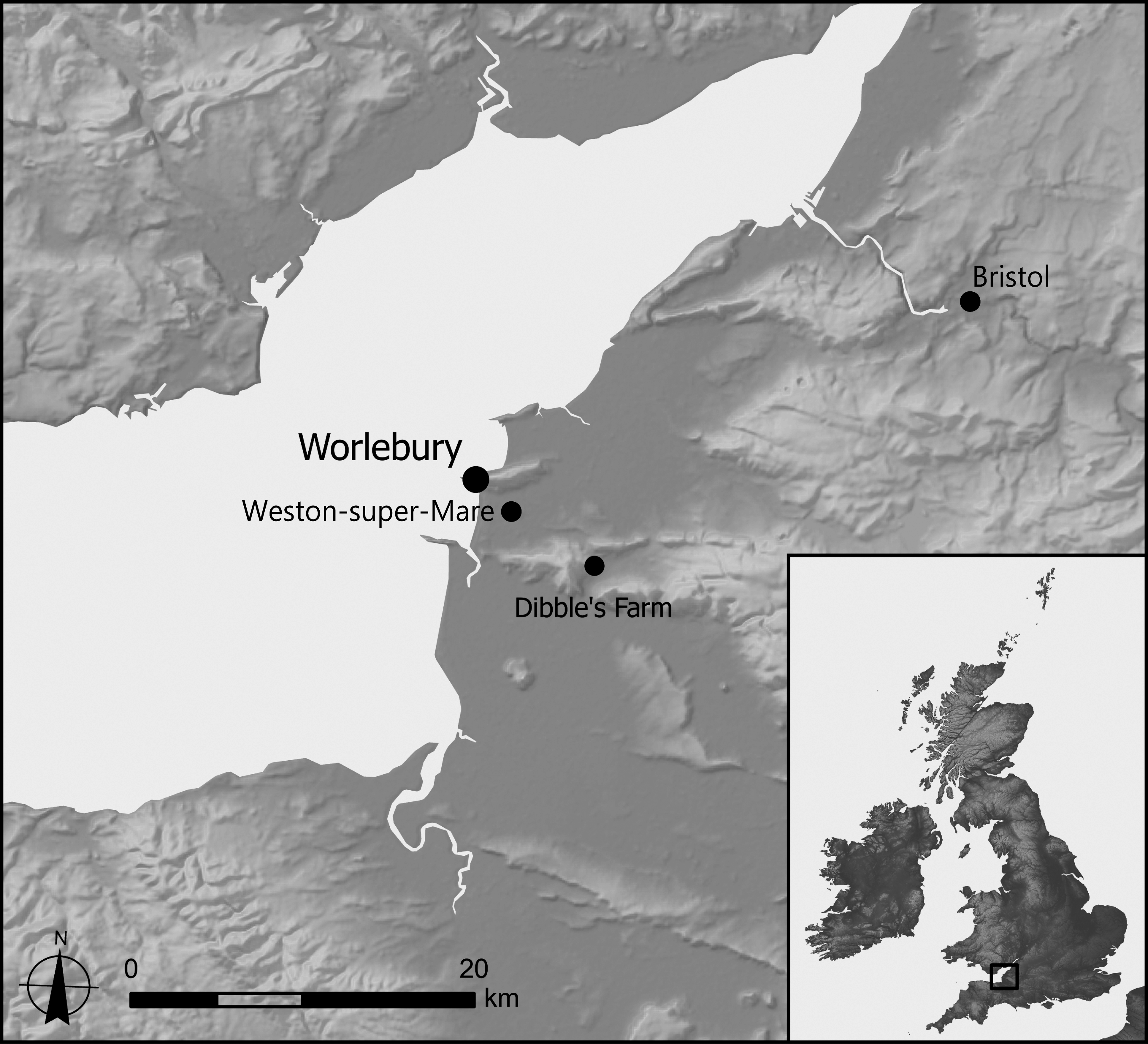
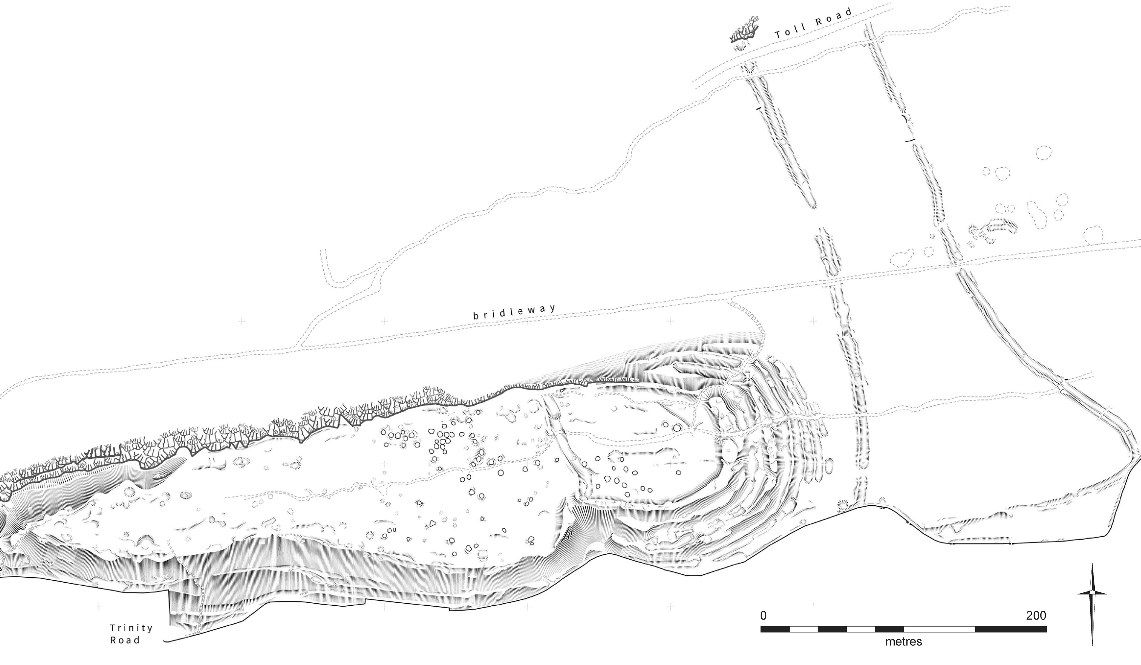
The hillfort of Worlebury (or Worlebury Camp) occupies the western end of a carboniferous limestone ridge known as Worle Hill (ST 312 625), immediately north of the modern town of Weston-super-Mare (Figure 1). The broadly sub-rectangular enclosed area measures c. 690 m E/W by 200 m N/S at its greatest extent, enclosing a total area of 14 ha, making it the largest hillfort in North Somerset (Lock & Ralston Reference Lock and Ralston2024). There are up to seven ramparts on its eastern side, ranging from 2–8 m wide and surviving to 0.5–1.5 m in height, with ditches ranging from 2–15 m wide and 0.5–1 m deep (Figure 2) (Robinson & Morton Reference Robinson and Morton2018, 21–2, fig. 9; Historic England 2022). No rampart is evident on the northern edge, where the steep cliffs of the promontory ridge likely served as a natural barrier. Similarly, the western side and much of the southern side of the hillfort have only one rampart, with banks up to 8 m wide. The ramparts themselves were built from rubble and faced with dressed stone quarried from the ditches (Bowden Reference Bowden2019, 6). Within the enclosure, running N–S and demarcating a smaller area to the east (known as the ‘keep’ or ‘annexe’), is a further ditch (Dymond Reference Dymond1902, 37). There is an entrance to the east, another to the south, just west of the interior dividing ditch, and a third on the western edge (Robinson & Morton Reference Robinson and Morton2018, 23–4). The southern entrance is thought to be the main entrance to the enclosure, and possibly the only one contemporary to the use of the hillfort, the others all being later (Dymond Reference Dymond1902, 33; Bowden Reference Bowden2019, 9).
Map by Helen Goodchild. Produced using Copernicus data and information funded by the European Union – EU-DEM layers; contains Ordnance Survey data © Crown copyright and database right 2025.

Survey plan of the hillfort and exterior linear ditches, reduced to 1:2000, showing the elaborate ditch system on the east side of the hillfort and the many pits in the interior. Source: adapted from Bowden Reference Bowden2019, fig. 2. © Historic England.

The site was first recorded by Rutter (Reference Rutter1829, 44–7), who noted the ramparts and ditches, and several ‘curious circles […] about 28 or 30 feet in diameter’ in the interior. Following this, the hilltop was planted with trees, which have caused substantial damage to the surviving features (Robinson & Morton Reference Robinson and Morton2018, 3; Brodie et al. Reference Brodie, Roethe and Hudson-McAulay2019, 10). The first survey and excavations began in 1851, when the Reverend Francis Warre and other local antiquaries excavated 93 pits in the interior (Warre 1851; Reference Warre1853). Finds included Iron Age and Romano-British artefacts and human remains representing at least 18 skeletons, although little contextual data was recorded.
In 1881–2, C.W. Dymond and Reverend H.G. Tomkins re-excavated some of the pits and dug the first sections through the ramparts and ditches (Dymond Reference Dymond1902, 38). Dymond’s 1902 publication discussed nine pits in more detail, using Warre’s earlier notes, and one, the ‘steened pit’ (Pit 9), was given a location within the hillfort and a section drawing (Dymond Reference Dymond1902, 77–9, pl. III & VII). This pit, which had been excavated in its entirety, contained three human skeletons, one with an apparent sharp-force wound to the skull (Dymond Reference Dymond1902, 77–9). Four more individuals, two with signs of trauma, were recorded within Pits 6, 7, and 8 (Dymond Reference Dymond1902, 77–8). According to Warre (Reference Warre1853, 124) and Dymond (Reference Dymond1902, 110–15), nine of the 18 total individuals from the early excavations showed signs of trauma, with both excavators interpreting the skeletal remains as having resulted from a single conflict event which had ended the use of the site. This ‘massacre hypothesis’ has remained the favoured interpretation of the site (eg, Evans Reference Evans1980).
More recent work on the site has been limited to two sections across the ditches excavated in the late 1980s (Fitzpatrick & Pirie Reference Fitzpatrick and Pirie1987; Pirie Reference Pirie1988), mapping of the hillfort by English Heritage, and surveys by both Cotswold Archaeology and Historic England (Carpenter Reference Carpenter2018; Robinson & Morton Reference Robinson and Morton2018; Bowden Reference Bowden2019). The most recent survey (Bowden Reference Bowden2019) is extremely thorough and well-researched, providing more detail than is possible here. Bowden was also the first to argue that the human remains from Worlebury may be part of the ‘normal’ spectrum of Iron Age practice, not a massacre (Bowden Reference Bowden2019, 22), albeit without conducting new analysis of the remains. No human remains have been recovered since the 19th century, and no internal features excavated. The chronology of the site has never been established.
The pits
The 93 pits excavated by Warre are largely confined to the eastern half of the hillfort and range from 1.8–2.4 m in diameter and 1–1.8 m deep (Evans Reference Evans1980, 5; Bowden Reference Bowden2019, 12). According to Warre (Reference Warre1851, 81), all contained a basal fill of stones, covered by black soil with surviving organic material including wood, followed by rubble and rock. Several locally-made pottery vessels, woven basketry, animal remains, spindle-whorls, bone awls, charcoal, pebbles, and fragments of burnt wood are also recorded, as well as preserved remains of six-row barley, spelt wheat, beans, and brome (Evans Reference Evans1980, 5). A blue glass bead, a decorated knife handle, a bronze ring, two iron rings, and other objects were also recovered (Evans Reference Evans1980, 7).
The human remains
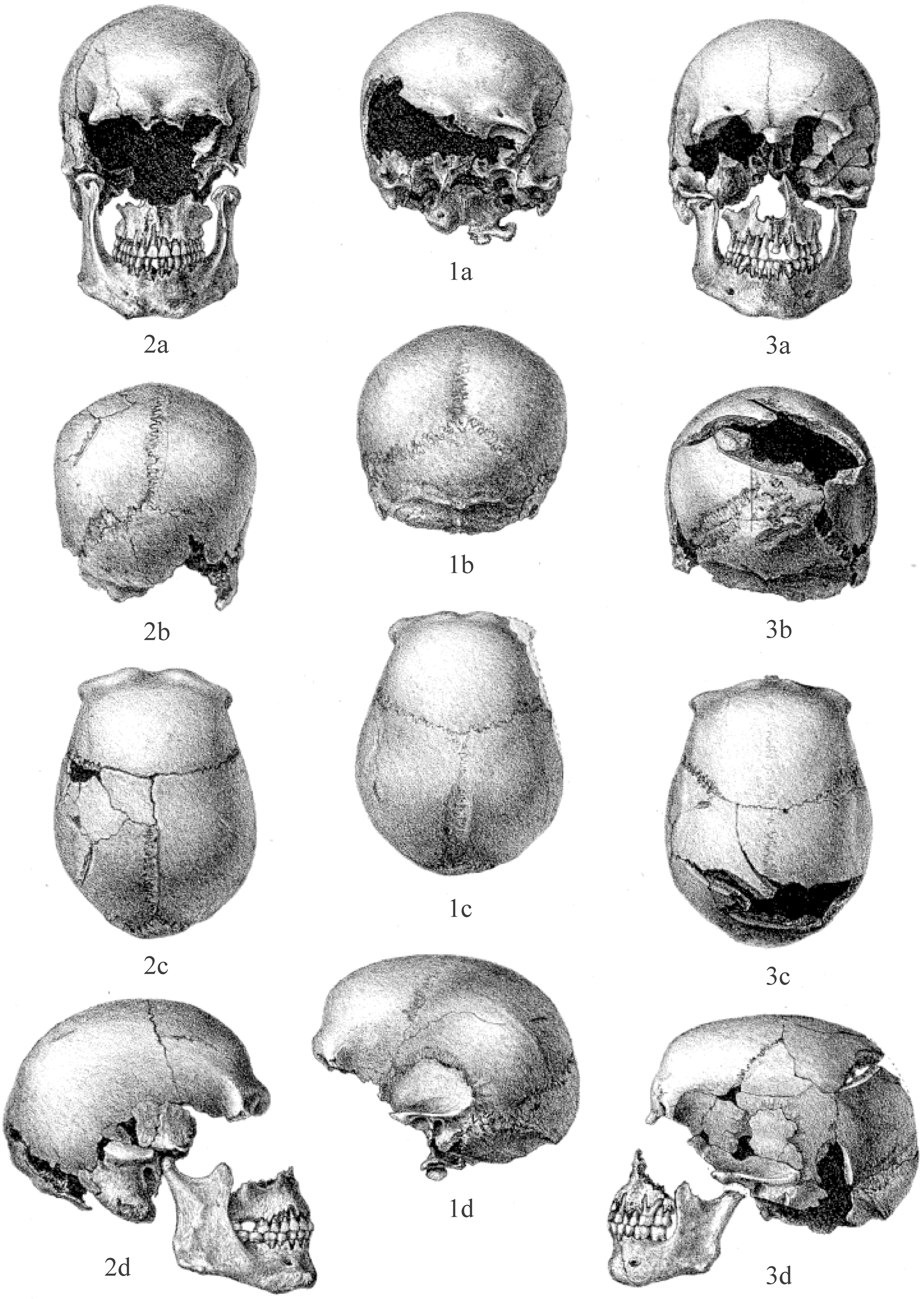
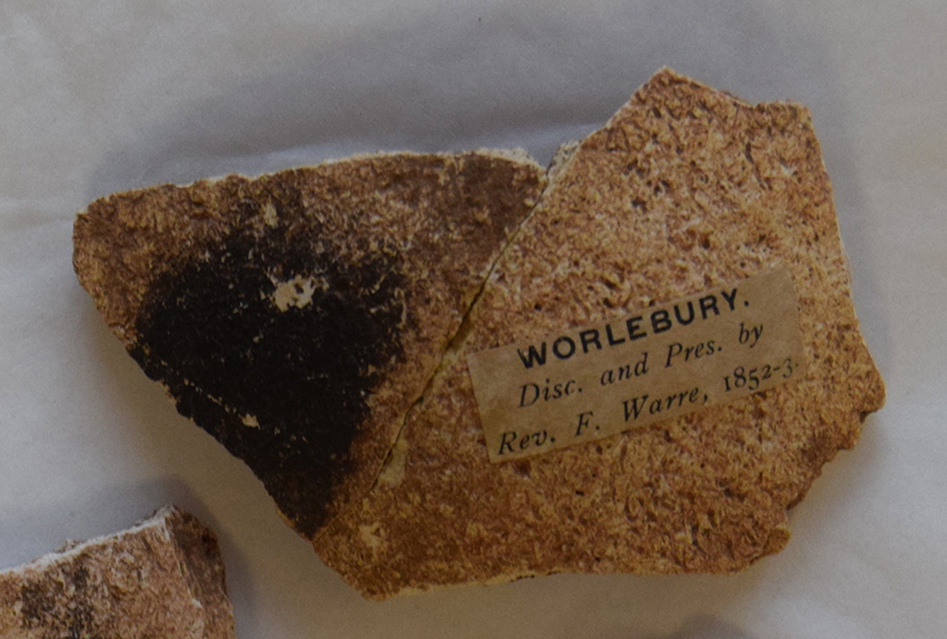
Although Warre believed that the human remains represented complete bodies, Dymond (Reference Dymond1902, 80) describes them as ‘portions of about 18 skeletons’. Some time between 1853 and 1886, the remains were divided between the then Albert Memorial Museum (Weston-super-Mare) and Taunton Castle Museum. Dymond and Tomkins (Reference Dymond and Tomkins1886, 102) were only able to access the former collection, which they sent to Professor MacAlister at Cambridge University, for osteological analysis. The remains in Taunton Castle Museum were not recorded explicitly, but Dymond and Tomkins (Reference Dymond and Tomkins1886, 102) mention that ‘the skull and other bones in the Museum’ could not be accessed, implying that only one skull, and perhaps bones from only one individual, were held in Taunton at this time. Several authors mention a skull with seven cut marks held in the Taunton Castle Museum (Dymond & Tomkins Reference Dymond and Tomkins1886, 77; Dymond Reference Dymond1902; St George Gray Reference St George Gray1905; Evans Reference Evans1980, 10). This was illustrated by Dymond (Reference Dymond1902, pl. XI) (Figure 3) and has been identified in the surviving collection, labelled Skull A.681. It is clear that MacAlister did not examine this cranium, or other bones also labelled A.681, including a cut-marked clavicle (below), as he makes no mention of them. It seems likely then, that these bones, nearly all of which also have a label glued to them that says ‘Worlebury. Disc. and Pres. by Rev. F. Warre, 1852–3’ (Figure 4), are (some of) the remains Warre deposited in Taunton Castle Museum. More than one individual is represented among these bones, but only one largely complete cranium is present.
Drawings of three skulls (1, 2, and 3), adapted from Dymond Reference Dymond1902, pl. XI. Cranium 1 (centre) has been re-identified as being from Pit 8, and has been located in the archive, the right parietal bone sampled for isotopes (WB08). Skull 2 (left) has been re-identified as being from Pit 9. Skull 3 (right) is the individual with ten perimortem SHA injuries, from an unknown pit, and now recorded as A.681. The mandible and maxilla that most likely belong to the second skull are labelled as Archtemp49 now, but were labelled as Archtemp51/Cranium III and A.681 in 2019, respectively. Isotope samples WB19, WB20, and WB21 were taken from parietal bones, occipital bones, and second molar teeth, but owing to mixing at the archive, it is unclear to which individuals these belong.

Cranial fragment a17 SID 6 with a label indicating it was donated by Rev. Francis Warre, 1852–3. Source: Laura Castells Navarro.

Dymond (Reference Dymond1902, 80) also mentions that one humeral head was cut from the rest of the bone, perforated, and burnt black. Although the object cannot now be located, there are parallels for similar objects made of human bone – amulets, loomweights, pendants, bowls – that have been found on Iron Age sites across Britain (eg, Cunliffe Reference Cunliffe1978, 36; Chowne et al. Reference Chowne, Cleal, Fitzpatrick and Andrews2001; Evans Reference Evans2013; Phillips & O’Brien Reference Phillips and O’Brien2016, 65).
At some point between 1902 and the present, the human remains were consolidated into a single archive at the Museum of Somerset (Taunton), with some bones on display in Weston Museum. These are the remains which have been re-examined osteologically in the present study and sampled for aDNA and AMS analysis. While successful attempts have been made to reconnect some specific bones with their contexts (below), the complex post-excavation history of the skeletal remains has left them commingled, with great uncertainty as to which individual, and which pit, they belong. As such, for the aDNA, AMS dating, and isotope analysis, each element is discussed as a standalone sample, rather than an ‘individual’. This approach allows us to discuss overall population patterns, without making potentially spurious assumptions about single individuals. Each accessioned element has an accession number, and some have additional identifying numbers and skeleton numbers. As well as this, each bone sampled for isotopes was given a sample number (WB01-29) and each aDNA sample was labelled (GENLAB 1-11). A full catalogue of the skeletal elements, with their accession and sample numbers, is contained in Supplementary S1.
Results
Recontextualizing the dead
The authors re-examined the paper archive at the South West Heritage Trust to determine whether more information could be extracted regarding the contexts in which the human remains had been found, thus enabling us to match the physical remains with the published records.
Pit 6
Pit 6 was 1.9 m ‘square’ and 1.8 m deep, and contained a single skeleton, crouched on their right side, with their head to the NW. They were largely complete except for the lower legs, though in a poor state of preservation. Three sharp-force trauma injuries were recorded on the cranium, penetrating entirely through the bone, with further cuts to the left humerus and one clavicle (Warre Reference Warre1851, 80). At least one cut was on the back of the cranium (WSM Gazette, Nov. 10th, 1851). Dymond (Reference Dymond1902, 77) describes one injury as ‘of a very peculiar form, as if inflicted by an instrument whose blade was terminated by a kind of pointed tooth’.
Pit 9
Pit 9 contained a wall or revetment of masonry at the base (the so-called Steened pit) and was 2 m deep, and 2.1 m in diameter at the surface. It contained three skeletons, one 0.2 m above the second, which was just slightly above the third. There is some confusion as to the identification of these skeletons; the WSM Gazette (Nov. 10th, 1851) records the upper skeleton (1) with their head N, the middle (2) with their head SW, and the lowest (3) with their head N, while Warre (Reference Warre1851) says that no. 1 had the head to the S, no. 2 WSW, and no. 3 N. Tomkins (Reference Tomkins1877) gives the same orientations as Warre but in no order. Dymond and Tomkins (Reference Dymond and Tomkins1886) elaborate, describing a large male, laid on their right side, with their head N, and facing E. This individual had signs of trauma (below). Number 2 was 0.2 m lower, on their left side, their spine against the E side of the pit (head S), and no. 3 had their head to the NW. In their 1902 publication, Dymond and Tomkins say the same, as does St George Gray (Reference St George Gray1905), though he orients no. 2 S-WSW and no. 3 NNW.
All three individuals were crouched or flexed, and all sources agree that no. 1 was a much larger skeleton than the others and its cranium was ‘cleft completely through’ or ‘cleft to the brain’ in more than one place, and the left femur was ‘severely wounded’. The Albert Memorial Museum Visitor’s Handbook for 1877 records the femur as being ‘gashed by a sword’, and Tomkins (Reference Tomkins1877) describes it as cut in an upward direction. Additionally, Warre (Reference Warre1851, 80) and Tomkins (Reference Tomkins1877, 387) state that part of the collarbone had been driven up into the arch of the lower jaw, as a result of rocks having been ‘violently thrown in on the bodies’ (Tomkins Reference Tomkins1877, 387). This could suggest that this individual had undergone a period of decay prior to the backfilling of the pit, or the remains were subsequently disturbed.
MacAlister’s notes record single bones in numerical order, rather than whole skeletons, so it seems that already by this time it was uncertain which bones belonged to which individuals. MacAlister (Reference MacAlister1886, 1) describes no. 1 as the skull of a muscular adult man (found in the masonry pit on October 21st, 1851), and that ‘on the left parietal bone is a sword cut, “a coward’s blow”’. This cranium is depicted by Dymond (Reference Dymond1902, pl. XI) (Figure 3) and recorded as being from Pit 9. MacAlister (Reference MacAlister1886, 1) also identified bone no. 9 as the femur of the same individual – ‘a strong, large bone […] the outer side of the thigh has a cut made probably by an axe stroke from behind’. MacAlister’s (Reference MacAlister1886, 1) bone no. 12, a right humerus, is similarly described as ‘an extraordinary bone of great length and strength’. While it cannot be proven that this bone belongs to the same individual, it is noticeably larger than the other surviving bones, fitting with the earlier descriptions of this skeleton.
At some point between MacAlister’s analysis and the present day, the mandibles, maxillae, and crania of several individuals have become mixed. During our analysis in 2023, cranium no. 1 was labelled as Archtemp51, alongside a mandible that did not fit the skull. In 2019, during isotope sampling, the same cranium and mandible were labelled as Archtemp49. Careful reanalysis (below) has confidently reunited the correct mandible and maxilla with this cranium, meaning that this individual is represented by a largely complete skull and dentition, femur, and possibly a humerus, and is contextually identifiable.
Pit 7
Pit 7 contained a single partial skeleton, lying prone, and consisting of the mandible, atlas vertebra, bones of one arm and hand, and the right foot. All were in a good state of preservation, the excavators believing that the moisture in this particular pit had caused the decay of the remaining bones (Warre Reference Warre1851; Dymond & Tomkins Reference Dymond and Tomkins1886).
Pit 8
Pit 8 contained two skeletons. The upper individual was nearly extended, the head and neck bent against the pit wall. The lower skeleton was described as ‘contorted to a remarkable degree’, the two together interpreted as having fallen into the pit in the middle of a conflict, with the lower skeleton having its ‘skull broken in against a sharp angle of rock at the bottom of the pit’ (Dymond Reference Dymond1902, 77). MacAlister’s (Reference MacAlister1886) notes record skull no. 2 as having been found on the same date that Pit 8 was excavated, and he identifies that the left half of the atlas is ossified to the occipital bone. The same skull is also illustrated by Dymond (Reference Dymond1902, pl. XI) (Figure 3), showing the fused atlas. The cranium has three blunt-force trauma injuries (below), which could suggest it belongs to the lower skeleton from this pit. This cranium (no maxilla or mandible) has been identified, analysed, and recontextualised.
The WSM Gazette (May 29th, 1852) mentions that ‘near the floor of the pit were some more human remains; amongst them was observable an arm bone, burnt to within an inch of the socket, though the latter fitted upon its ball, untouched by the fire’. This bone is not mentioned by any other source and does not survive in the museum collections. Dymond (Reference Dymond1902) does mention a hemisphere of humeral head – cut smooth, bored through for suspension, and blackened – found in 1852 but without mentioning a specific pit. St George Gray (Reference St George Gray1905, 24) identifies this latter bone as a femur head, and compares it to similar examples from Glastonbury Lake Village, Ham Hill, and other sites.
Summary
Counting the burnt humerus and femur, the above totals eight individuals, of which only six were largely complete. The only source that describes further discoveries of human remains with their contexts is the WSM Gazette (May 29th, 1852), which mentions three further pits, containing two fragments of human skulls, and a loose tooth, respectively. Even if these three are from separate individuals, the described total for the site is still only 11, not the 18 recorded by the excavators.
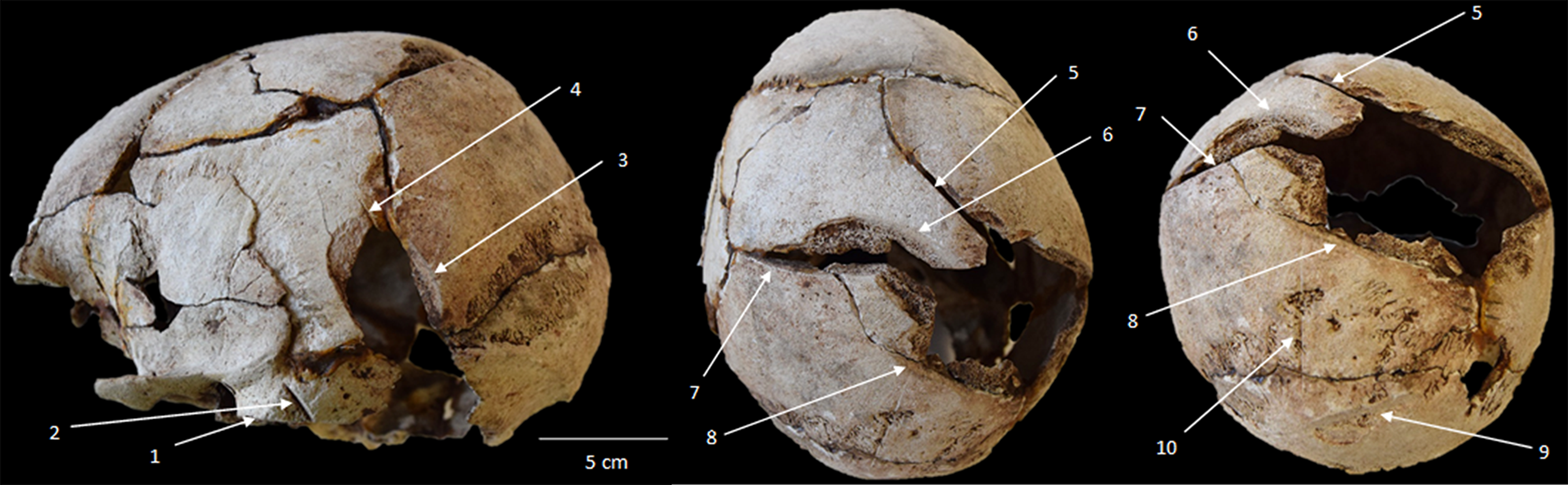
Other human remains were mentioned by multiple authors, but without recorded contextual information of any kind, so it is uncertain if these bones are from individuals already discussed above. Scarth (Reference Scarth1875) and Dymond (Reference Dymond1902, 79) record disarticulated lumbar vertebrae from one pit. The Albert Memorial Museum Visitors Handbook (Jackson Reference Jackson1877) and Dymond (Reference Dymond1902) both note that a child’s mandible was found. Evidence of trauma is recorded in all sources, often identically, and unfortunately, often without reference to the specific individuals concerned. Multiple authors claim that ‘half’ of the 18 skeletons had some form of perimortem trauma. Dymond & Tomkins (Reference Dymond and Tomkins1886), Dymond (Reference Dymond1902), and St George Gray (Reference St George Gray1905) all identify a skull in Taunton Museum with seven sword cuts (Figures 3 & 5), but do not connect it to the skeleton from Pit 9 with 3+ sharp-force trauma injuries. Dymond (Reference Dymond1902) also mentions one individual was decapitated by a sword cut through the atlas vertebra.
Cranium A.681, showing 10 perimortem sharp-force injuries (Left to right: left lateral, superior, and posterior views). Source: Laura Castells Navarro.

Osteological reanalysis
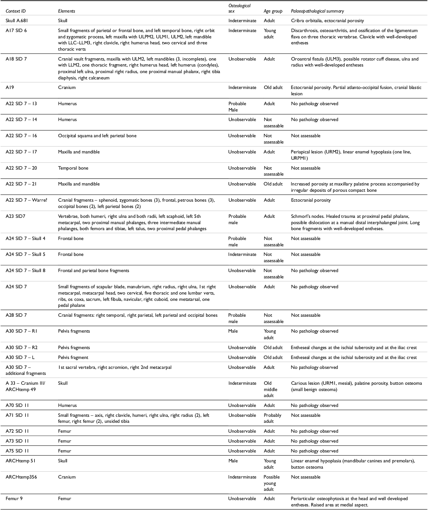
Osteological re-assessment of the remains suggests that they consist of a minimum of nine individuals as identified by the frontal bones (Table 1). Cranial bones account for 15.8% of the remains, the most numerous without considering single teeth (which account for 33.4% of the elements/fragments recovered). Following frontal bones, thoracic vertebrae, fragments of pelvis and ribs, mandibles, humeri, and femora were the most common (Supplementary S1). Despite varying degrees of representation, almost all parts of the body are present to an extent, including small bones of the hands and feet, though there are no sacra or patellae.
Demographic and palaeopathology data for Worlebury (ULPM2: Upper left second premolar; ULM1–3: Upper left first, second, and third molars; URPM1: Upper right first premolar; URM1–2: Upper right first and second molars; LLC–LLM3: Lower left canine to third molar; LLM2: Lower left second molar). In parentheses: indicates number of fragments. Context ID is a combination of the accession number and numbers given by MacAlister (see Supplementary S1)

Only five elements provided osteological sex data, of which all were estimated as male (Table 1), and all the remains were assessed as adult. Four elements were determined to have belonged to young adults and two to older adults; the rest could not be more precisely estimated.
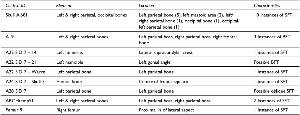
A summary of the pathological lesions observed in the remains can be found in Table 2. One of the most salient features is the high level of trauma, especially sharp-force. Five of the nine crania show instances of sharp-force trauma, and another shows multiple lesions consistent with blunt-force trauma. Additionally, one mandible shows potential blunt-force trauma and two elements of the postcranial skeleton (a humerus and a femur) show one instance of sharp-force trauma each (Table 2).
Perimortem trauma observed on the remains from Worlebury (SFT: sharp-force trauma; BFT: blunt-force trauma)

The most remarkable element is Skull A.681 with 10 instances of sharp-force trauma concentrated on the left parietal (and extending to the right) and occipital bones. Whilst post-mortem damage prevents an exhaustive analysis of the order in which these blows were struck, this cranium could be classified as an example of overkill comparable, for example, to the cranium and vertebrae from Stanwick (Wheeler Reference Wheeler1954, 53–4; Haselgrove Reference Haselgrove2016) and to the lesions observed in Individual 59 from Burnby Lane (Caffell & Holst Reference Caffell and Holst2022).
In general, the bones on the left side are more often affected than those on the right, suggesting – if the victim and assailant were face-to-face – that the assailant may have been right-handed (Manzon et al. Reference Manzon, Rinaldo and Gualdi-Russo2024). However, this arrangement is not exclusive, as exemplified by Skull A.681, A19, Skull 5, and ARCHtemp51, where the injuries are located on both parietal bones as well as the squama of the frontal bone.
Destructive analysis
The post-excavation treatment of the Worlebury human remains (decontextualization, commingling, glue) has severely limited their interpretative potential, and so destructive sampling (aDNA, isotopes, histology) was vital in gaining an understanding of the Worlebury population. Every effort was made to reduce the impact on the material, with minimum sample weights and sizes targeted (c. 200 mg of bone, c. 30 mg of enamel, c. 20 mm x 10 mm sections). Samples were stored in a dedicated human remains sample area leading up to analysis. Destructive sampling for isotope and histological analysis was subject to full approval from Cardiff University Research Ethics Committee. All sampling was undertaken in accordance with ethical considerations outlined by Squires and colleagues (Squires et al. Reference Squires, Booth, Roberts, Squires, Errickson and Márquez-Grant2019), and the BABAO codes of ethics and practice (BABAO 2019a & b), along with the support of the South West Heritage Trust. Sampling and analysis for ancient DNA was undertaken in accordance with the ethics and practice procedures described in Alpaslan-Roodenberg et al. (Reference Alpaslan-Roodenberg and Zahir2021). All extant sampled material used for DNA or isotope analysis has been returned to the curating institution (South West Heritage Trust) along with pre- and post-sampling photographs.
DNA analysis
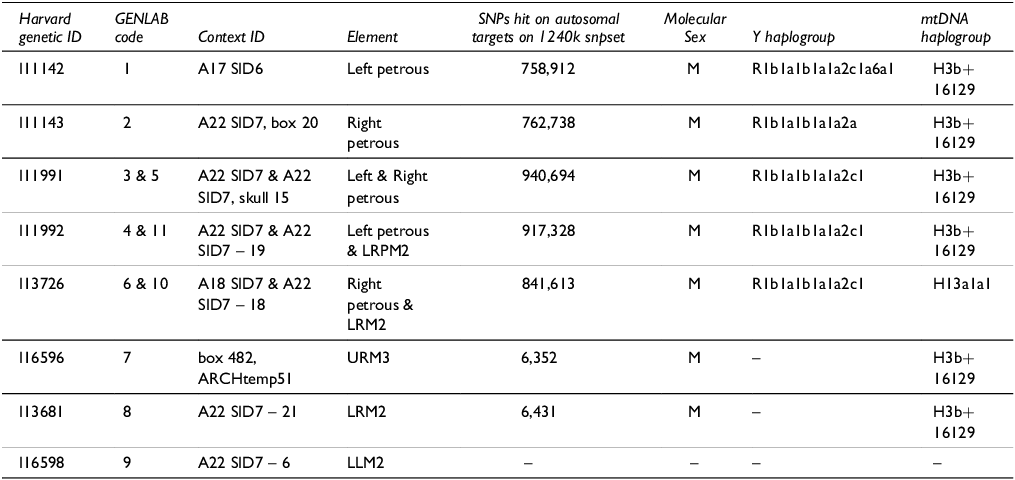
Eleven samples were initially selected for aDNA analysis, comprising six petrous bones and five teeth. Ten samples yielded usable genetic information, although it was found that several elements that had been separately coded and boxed in the site archive in fact belonged to the same individuals, resulting in three pairs of duplicates. In all, seven unique individuals were identified (Table 3). Data quality was excellent for the five samples where a petrous was available, but less good for two represented only by teeth. These bones are recorded as Skeletons 6 (a22 SID 7) and 21(A22 SID 7), the skeleton number likely originating from MacAlister’s original analysis (see above and Supplementary S1). A further tooth, extracted from Skeleton 6, failed to produce any results. The aDNA data from Worlebury were initially published (though without site-specific interpretation) as part of a wider study of inter-regional population movement in Bronze and Iron Age north-west Europe (Patterson et al. Reference Patterson and Reich2022), and the raw data are thus available through the European Nucleotide Archive under accession number PRJEB47891. A full statement of the analytical methods is in the original publication.
aDNA samples from Worlebury (M: Male; SNPs: Single Nucleotide Polymorphism; mtDNA: mitochondrial DNA; LRPM2: lower right second premolar; LLM2: lower left second molar; LRM2: lower right second molar; URM3: upper right third molar)

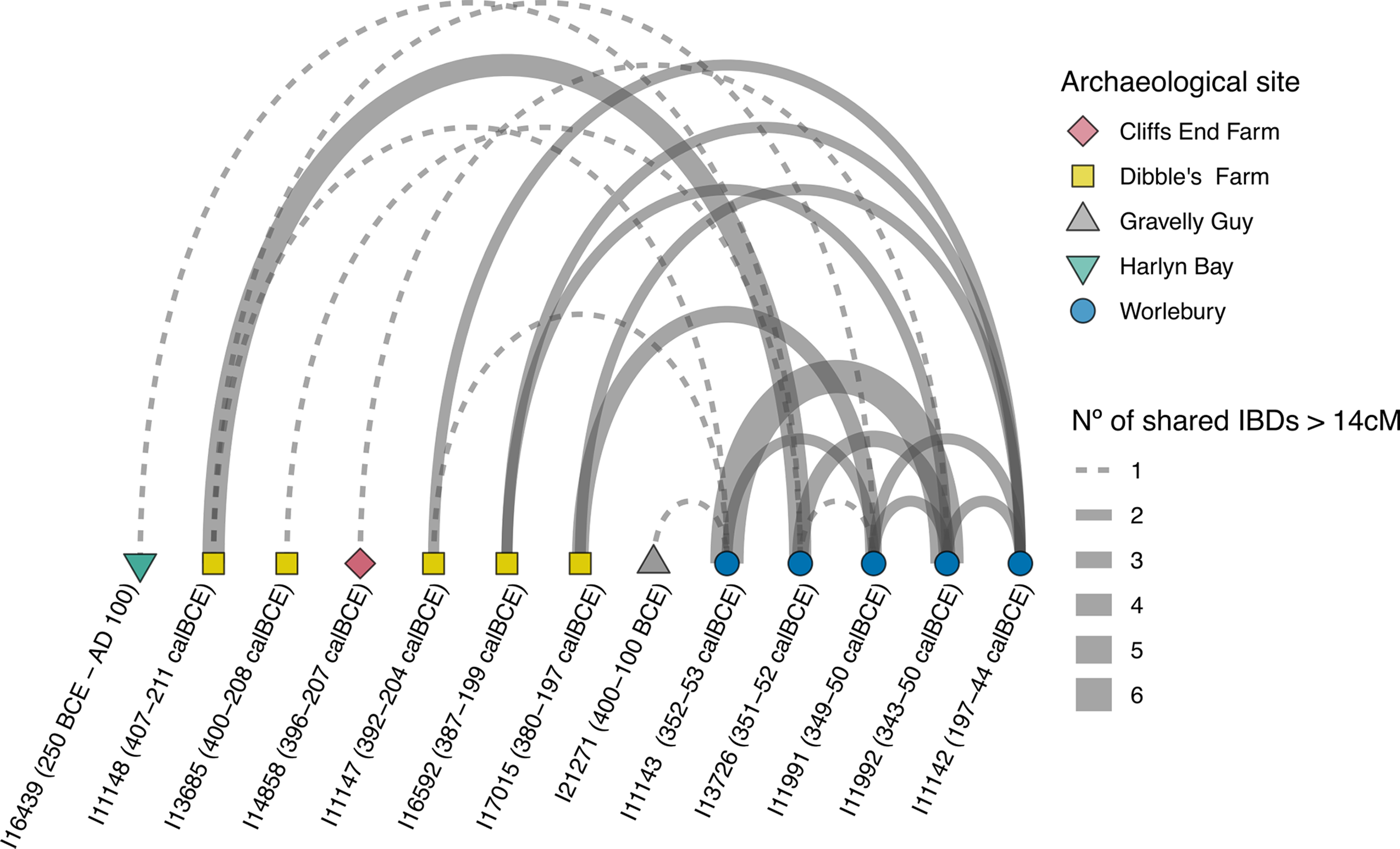
All seven unique individuals were found to be male and in the five cases where their Y chromosome (paternal) haplogroup could be determined, all belonged to the R1b haplogroup. This is the dominant Y-chromosome haplogroup found in British Iron Age populations, having been introduced through population movement into Britain from Continental Europe during the late 3rd millennium BC (Haak et al. Reference Haak and Reich2015; Patterson et al. Reference Patterson and Reich2022), and is thus uninformative regarding potential biological relatedness between these individuals. Importantly, however, six of the seven individuals carried the H3b+16129 mtDNA (maternal) haplogroup, the sole exception being Skeleton 18 (A18 SID 7, I13726) (Table 3). This is a striking result, given the generally wide diversity of mtDNA haplogroups in prehistoric populations (Patterson et al. Reference Patterson and Reich2022). Although kinship analysis using the software READ (Monroy Kuhn et al. Reference Monroy Kuhn, Jakobsson and Günther2018) identified no close biological relationships (i.e. to the 1st or 2nd degree), subsequent analysis using IBD (Identity-by-Descent) revealed a series of more distant biological relationships between all five high coverage individuals, suggesting that they were related at the 3rd degree or more (eg, as first or second cousins) (Figure 6; Supplementary S2).
Arch plot illustrating biological relationships between individuals based on Identity-by-Descent (IBD) analysis. Only IBD segments longer than 14 cM were considered. The width of each connection represents the number of shared IBD segments exceeding 14 cM between the linked individuals. Source: Sebastian Metz.

We also identified biological relationships between all five high coverage individuals from Worlebury and a group of earlier individuals at the Iron Age enclosure of Dibble’s Farm, around 8 km to the SE (Morris Reference Morris1988; some of these IBD relationships were previously observed by Cassidy et al. Reference Cassidy and Bradley2025). Notably, four of the Worlebury individuals had IBD links to an adult female, c. 35–45 years at death, buried with a perforated boar’s tusk in a deep pit (Pit XXXVII) at Dibble’s Farm. This woman appears to have died around a century prior to the Worlebury individuals (2297 ± 30 BP, SUERC-94981, 406–233 cal BC), suggesting that some members of the Dibble’s Farm population may have been direct biological ancestors of the Worlebury population (a full list of AMS dates from Dibble’s Farm is contained in Patterson et al. Reference Patterson and Reich2022).
Finally, our IBD analysis also revealed biological relationships between the Worlebury population and single individuals from Gravelly Guy, Oxfordshire (Lambrick & Allen Reference Lambrick and Allen2005), Cliffs End Farm, Kent (McKinley et al. Reference McKinley, Leivers, Schuster, Marshall, Barclay and Stoodley2014), and Harlyn Bay, Cornwall (Whimster Reference Whimster1977). These distant and disparate biological relationships hint at widespread social networks linking communities across substantial tracts of southern Britain in the last few centuries BC (Figure 6; Supplementary S2).
Radiocarbon dating and chronological modelling of human remains
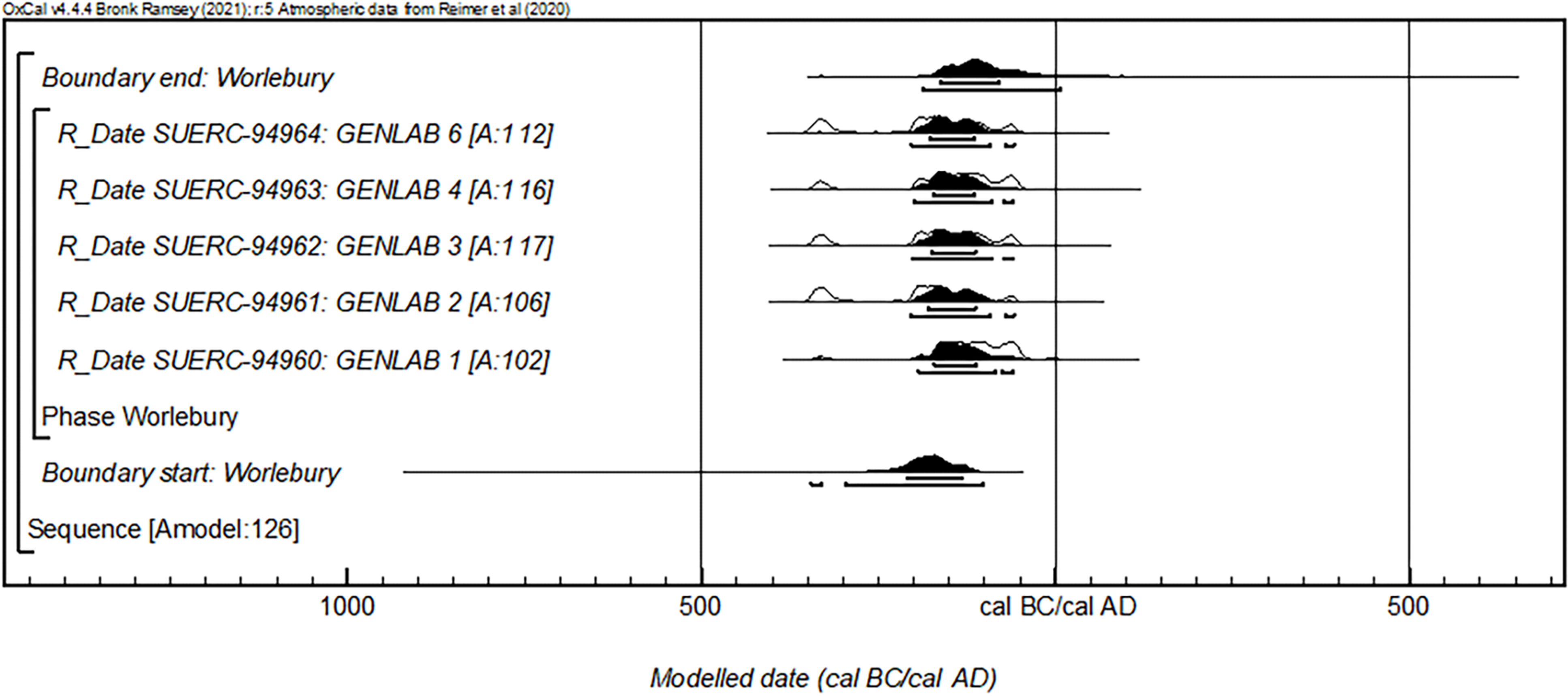
Five AMS dates were obtained on human remains from Worlebury using the same petrous bones sampled for aDNA analysis (Table 4). The dates form a consistent series focussed on the period between 300–50 cal BC.
AMS radiocarbon dates from the Worlebury individuals sampled for aDNA. The radiocarbon ages have been calibrated using the IntCal20 calibration curve (Reimer et al. Reference Reimer and Talamo2020) and OxCal v.4.4 (Bronk Ramsey Reference Bronk Ramsey2009; Reference Bronk Ramsey2021). They are presented as single probability ranges rounded outward to the nearest 10 years

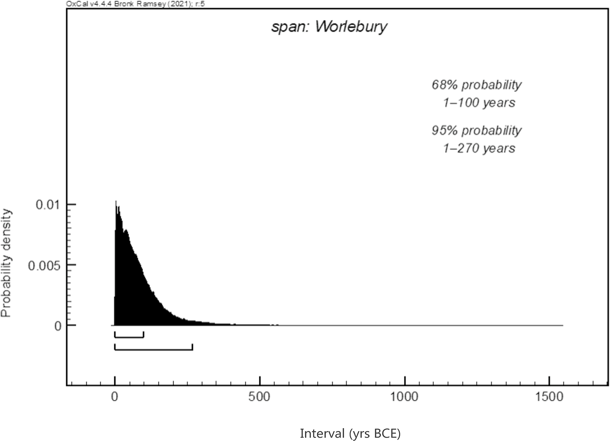
A Bayesian approach has been applied to provide a chronological framework within which the burial activity and the aDNA results can be considered. The model follows the simple bounded phase form described in Hamilton and Kenney (Reference Hamilton and Kenney2015). Modelling was undertaken using OxCal v.4.4 (Bronk Ramsey Reference Bronk Ramsey2021) and the endpoints are rounded outward to 5 years. The model has good agreement (Amodel=126) and estimates the dated burial activity began in 300–100 cal BC (95% probability; Figure 7; start: Worlebury) or 210–130 cal BC (68% probability). The activity ended in 190 cal BC–cal AD 10 (95% probability; Figure 7; end: Worlebury) or 165–80 cal BC (68% probability). The overall span of activity is estimated to have been 1–270 years (95% probability; Figure 8; span: Worlebury) or 1–100 years (68% probability).
Chronological model for burial activity at Worlebury. Each distribution represents the relative probability that an event occurred at some particular time. For each of the radiocarbon measurements, two distributions have been plotted, one in outline, which is the result of simple radiocarbon calibration, and a solid one, which is based on the chronological model used. The other distributions correspond to aspects of the model. For example, ‘start: Worlebury’ is the estimated date that the human pit burials began, based on the radiocarbon dating results. The large square ‘brackets’ along with the OxCal keywords define the overall model exactly. Source: Derek Hamilton.

Span of the burial activity modelled at Worlebury. The spans are derived from the modelling shown in Figure RC-1. Source: Derek Hamilton.

The low number of radiocarbon dates has resulted in a chronological model that likely overestimates the duration of activity (Steier & Rom Reference Steier and Rom2000). While a statistical comparison of the radiocarbon measurements demonstrates their consistency (T’=1.5; df=4; T’(5%)=9.5 (Ward & Wilson Reference Ward and Wilson1978)), it must be remembered that the measurements intersect with a portion of radiocarbon calibration curve that is characterised by a strong wiggle, which has an effect similar to that of a plateau, whereby similar radiocarbon ages span a large number of calendar years. Therefore, statistical consistency would be expected in this period even if the individuals all died over a period of around 200 years (but not as many as the full 300 years represented by the calibrated results). Overall, the model clearly allows for the possibility that all of the dated individuals died in the same event, although it cannot, by its nature, confirm this.
Isotope analysis
Isotope samples from 29 human bones were taken in 2018 as part of the Cardiff Undergraduate Research Opportunities Programme (CUROP). The bones were sampled for stable carbon (δ13Ccoll) and nitrogen (δ15N) isotope analysis, and strontium (87Sr/86Sr), oxygen (δ18O), and carbon (δ13Ccarb) isotope measurements were taken from the enamel of six teeth. A range of bones were sampled for δ13C and δ15N including long bones, skull fragments, and mandibles/maxillae. For the 87Sr/86Sr, δ18O, and δ13Ccarb isotope analysis, enamel was sampled from a first molar, second molars (n = 4), and a single premolar. Additionally, δ13C, δ15N, and δ34S values were generated for petrous samples AMS-dated at SUERC in 2020. This paper combines the results from the two institutions giving a combined total of 34 sampled bones. Multiple analyses were undertaken where possible, however, it is likely some repeat sampling of individuals has occurred due to the disarticulated state of the remains and lack of contextual information. Full methods, quality controls, and results are presented in Supplementary S5.
Results
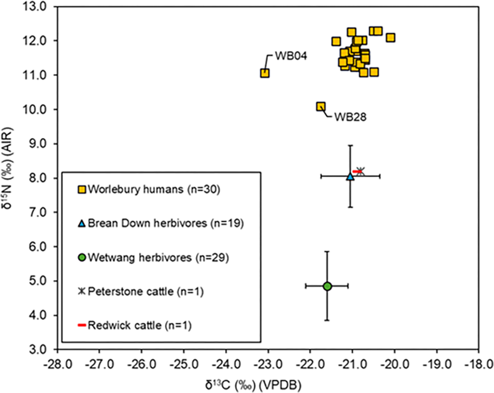
The δ13C and δ15N values range from -23.1‰ to -20.1‰ and 10.1‰ to 12.8‰ respectively. The majority of individuals have similar values across the two dietary isotope proxies (Figure 9) with the exception of two outliers (>1.5 x IQR). Sample WB04 (a17 SID 6) has the lowest δ13C value of the assemblage (-23.1‰) while sample WB28 (same accession number) is an outlier for both δ13C (-21.8) and δ15N (10.1‰). Interpreting the Worlebury human δ13C and δ15N results is limited by the absence of local fauna, and as such, isotope results for the cemetery of Wetwang Slack (East Yorkshire) have been used as a representation of a settled Iron Age community with a uniform diet, while mammalian values from Bronze Age sites of Brean Down, Peterstone, and Redwick have been added as proxy sites along the Severn Estuary. This represents a sub-optimal baseline and must be used with caution. The Worlebury mean δ13C value (-21.0‰) is similar to the Wetwang Slack human mean value of -20.5‰ (Wetwang Slack δ13C range: -21.2‰ to -19.9‰, n = 61). In contrast, the Worlebury δ15N mean value (11.6‰) is much higher than the Wetwang Slack mean δ15N value of 9.7‰ (δ15N range: 8.6‰ to 12.3‰, n = 61) (Jay & Richards Reference Jay and Richards2006). Since the elevated δ15N values are not accompanied by more positive δ13C values, this does not suggest marine consumption at Worlebury. A likely explanation for the high δ15N values at Worlebury is that the community consumed animals that had grazed in a salt-marsh environment, which is consistent with the site’s location. This is supported by the (c. 3‰) difference between the Brean Down herbivore δ15N mean (8.1‰) and the Worlebury human δ15N mean (11.6‰), which is consistent with the trophic spacing that would be anticipated if the humans were consuming animals from a similar environment. In contrast, the mean δ15N value for Wetwang Slack herbivores (cattle, sheep, and goats) (n = 29) is 4.9‰, consistent with fully terrestrially feeding animals. This suggests that the majority of Worlebury humans were local to Worlebury in the years before death, and that salt-marsh was an important resource for raising livestock.
Carbon (δ13C) and nitrogen (δ15N) values for Worlebury human bone collagen compared to published faunal results from Brean Down, Peterstone, and Redwick (Britton et al. Reference Britton, Müldner and Bell2008) and Wetwang Slack (Jay & Richards Reference Jay and Richards2006). Individuals WB04 and WB28 are outliers when compared to the rest of the Worlebury samples. Source: Madeleine Bleasdale.

δ34S measurements for the five petrous bones radiocarbon dated at SUERC range from 12.3‰ to 14.6‰, with a mean of 13.1‰ (SD = 0.9, n = 5). The results are relatively consistent with the geology surrounding the hillfort (range = 4.8–11.6‰ (Hamilton et al. Reference Hamilton, Fox, Adams, Alexander, Sayle, Steinke and Stephens2022)) when allowing a slight increase for a ‘sea-spray effect’ (Zazzo et al. Reference Zazzo, Monahan, Moloney, Green and Schmidt2011). This suggests the Worlebury individuals consumed local resources during early childhood.
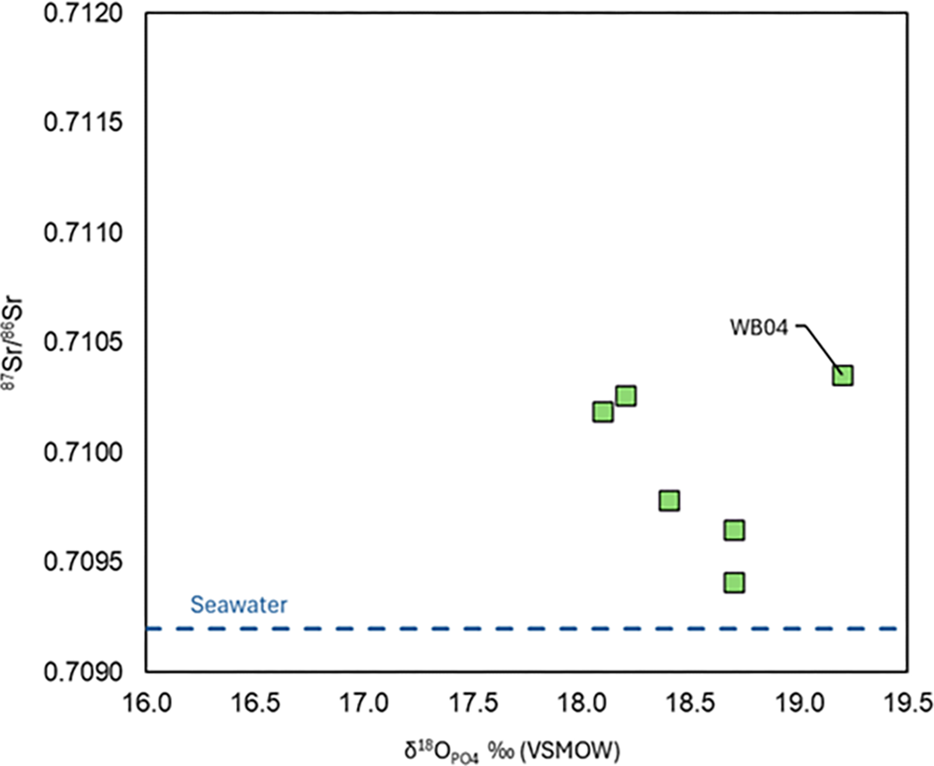
The Worlebury 87Sr/86Sr and δ18Ocarb enamel results are presented in Figure 10. The 87Sr/86Sr values range from 0.7094–0.7104 with a mean value of 0.7099 (SD: <0.01). All fall within the immediate predicted local 87Sr/86Sr range or slightly higher values seen in neighbouring areas, based on strontium basemap data produced by Evans and colleagues (Evans et al. Reference Evans, Mee, Chenery and Marchant2022), with a predicted 87Sr/86Sr biosphere range of 0.7095–0.7110 (central 50%).
Strontium (87Sr/86Sr) and oxygen ((δ18OPO4 ‰ [VSMOW]) results for Worlebury enamel samples. The 87Sr/86Sr value for seawater (0.7092) is shown by the dashed blue line. N.B. δ18O isotope analyses were undertaken on the carbonate fraction of enamel, but are expressed as phosphate values for ease of comparison with the majority of published data. Source: Madeleine Bleasdale.

The Worlebury human enamel δ18O values range from 18.1‰ to 19.2‰ with a mean of 18.6‰ (SD: 0.4). All but one fall within the predicted range for the local area; the only outlier being WB04, which is also an outlier for δ13C and δ15N. The enamel δ13C values range from -15.3‰ to -14.1‰ with a mean value of -14.7‰ (SD: 0.4). The Worlebury enamel results suggest a predominantly C3-based diet during childhood, assuming an approximate 10% offset between tooth enamel and diet (Schoeninger Reference Schoeninger2014).
Summary
The Worlebury δ13C and δ15N results suggest that these individuals likely consumed a predominantly C3-based diet with no substantial amounts of marine protein, which is typical for the period (Dobney & Ervynck Reference Dobney, Ervynck, Haselgrove and Moore2007; Rainsford & Roberts Reference Rainsford and Roberts2013). Their high δ15N values are most likely due to consuming local resources and animals that have grazed in the local salt-marsh environment. This pattern is also observed in Bronze Age faunal assemblages from around the Severn Estuary (Britton et al. Reference Britton, Müldner and Bell2008), though at Worlebury caution is needed due to the absence of a local faunal baseline.
Barring one sample, the Worlebury 87Sr/86Sr and δ18O results are consistent with these individuals living in a coastal location in southern Britain during childhood. The δ34S isotope results also support an early childhood in the local area though other areas cannot be excluded. The single outlying δ18O sample, WB04, has an δ18O value that is at the upper end of the range for the UK, suggesting a potential origin in a warmer climate (eg, the Mediterranean). However, this result may be affected by the breastfeeding signal as a first molar was analysed, making it challenging to confirm with certainty whether this individual is non-local. In addition, there is increasing evidence that values in this range can be obtained for humans in western Britain, though datasets remain small compared to other parts of the UK (Rainbird et al. Reference Rainbird, Coles and Payne2022; Faillace & Madgwick Reference Faillace, Madgwick, Gilbert, Morgan-James and Sinnott2024). The combined isotope results for the Worlebury humans are consistent with the majority living in a coastal location in southern Britain during childhood, and therefore they most likely represent a local group.
Taphonomic analysis
Histological analysis was undertaken on the same human bones that were subject to initial (CUROP) isotope analysis (19 from the cranium and nine from the postcranial skeleton). Thin section slides used for histological analysis are archived at Cardiff University BioArchaeology Laboratory. A full report is included in Supplementary S4. The subdiscipline remains at a developmental stage, and while it is evolving rapidly, at present there remains no consensus on the origins of bacteria and thus the interpretative potential of histotaphonomic data (see Jans et al. Reference Jans, Kars, Nielsen-Marsh, Smith, Nord, Arthur and Earl2002; Reference Jans, Nielsen-Marsh, Smith, Collins and Kars2004; Booth Reference Booth2016; Booth et al. Reference Booth, Bronnimann, Madgwick, Portmann, Knüsel and Schotsmans2022; Reference Booth, Bricking and Madgwick2024; Turner-Walker et al. Reference Turner-Walker, Galiacho, Armentano and Hsu2023; Mavroudas et al. Reference Mavroudas, Alfsdotter, Bricking and Madgwick2023; Schotsmans et al. Reference Schotsmans, Stuart, Stewart, Thomas and Miszkiewicz2024). These data are interpreted on the basis of an endogenous model of bioerosion, though further experimental research is required to clarify the drivers of variation and consequently findings may require future interpretative revision.
Of the 28 samples, 23 showed almost complete histological destruction through bioerosion, with Oxford Histological Index (OHI, Millard Reference Millard, Pollard and Brothwell2001) scores of 0 and budded microbial attack (Hackett Reference Hackett1981) overwhelmingly dominant. Poorly preserved histology is dominant across postcranial and cranial remains, fragmentary and complete elements, those with and without sharp-force trauma, and those with poorly and well-preserved cortical surfaces. Four samples produced OHI scores of 1. In all instances, areas of microstructural preservation were very limited, with occasional osteons retaining integrity or, in some instances, portions of the periosteal surface being well preserved. This is insufficient to be suggestive of a different mode of early post-mortem treatment and can be considered broadly representative of a mortuary practice in which soft tissue degraded slowly, allowing the transmigration of bacteria into the bones. Although in varying states of articulation, evidence indicates that these remains were all deposited fleshed and subject to burial shortly after death. Only one sample showed a different pattern of preservation. A mandible with associated maxilla, WB24, showed markedly better histological preservation (OHI 2), suggesting that the bone was subject to different treatment, possibly a form of sheltered exposure resulting in delayed, but nonetheless fairly rapid, soft tissue degradation prior to final deposition. The lack of contextual information means more detailed interpretation is not possible. Macroscopic taphonomic changes to the bones were limited; one mandible was possibly slightly weathered (Stage 1, Behrensmeyer Reference Behrensmeyer1978), and one femur had potential trampling marks, but confirmation was hampered by root etching, poor cortical preservation, post-excavation damage, and glue on the surface of many bones.
Discussion
Identifying a local population
Reanalysis of the human skeletal remains and the written archive has resulted in the most complete picture so far of the population of Worlebury. The isotope data reveal a group who were raised locally, and continued to live there in adulthood, consuming predominantly C3 plants (such as barley, cereals, oats, and wheat) and animals raised in a salt-marsh environment. Worlebury sits above the Severn Estuary, which is one of the few remaining salt-marsh landscapes in the UK. The genetic and osteological data highlight an unrepresentative population of adult males, at least five of whom were biologically related to the third degree or more (first or second cousins), six of them sharing a maternal lineage. Their genetic connection to the earlier site of Dibble’s Farm demonstrates a tangible link between the two sites, potentially indicating that the occupants of Worlebury were directly descended from those at the nearby settlement.
Depositing the dead
Warre (Reference Warre1851, 80–1) states that all the pits had broadly the same depositional sequence – stones at the base, then black earth and wood, then rubble and rock (1.5 m deep), and finally natural silting. The human remains are implied to have been found at the base of the rubble deposits, originally thought to be a destruction layer. However, of the nine pits described by Dymond, the rubble deposit is only explicitly mentioned for Pit 9 (Reference Dymond1902, 76–9). One of the three skeletons in this pit was separated from the others by 0.2 m, but since Warre (Reference Warre1851) and Dymond (Reference Dymond1902, 78; PSANHS 1885, 14–15) mention that the bodies were surrounded by rubble, this 0.2 m separation need not equate to a long period between the deposition of each individual. Dymond (Reference Dymond1902, 76–7) describes the skeleton from Pit 6 as having been deposited only 0.15 m from the base, while that from Pit 7 lay above multiple fills of grain, dark soil, and organics. Both are recorded as being at a depth of 1.5–1.7 m below the surface, but Pit 7 was much deeper than Pit 6 (Dymond Reference Dymond1902, 77), suggesting that the stratigraphic context of the human remains differed between these pits. Dymond also mentions that one of the two individuals in Pit 8 had their skull broken against a rock at the bottom of the pit, which would either suggest that this pit was newly opened when the skeletons were interred, and had not accumulated any other fills, or that these two skeletons were perhaps earlier than the others. Given that 93 pits were apparently excavated within the hillfort, it is likely that several were open at the same time, so the presence of human remains in more than one pit, or at different depths, neither precludes nor proves a single-event hypothesis. If the large rubble fill was present above the skeletons in each pit, it would echo destructive events noted at other hillforts (below), where the dead were covered by the rubble from levelled ramparts.
Almost all skeletal elements are represented at least once in the recovered assemblage, despite their relatively crude excavation, and their repeated movement and reorganisation within museum collections over almost two centuries. The presence of small bones suggests that the remains were substantially fleshed when deposited (Fernández-Jalvo & Andrews Reference Fernández-Jalvo and Andrews2016, 314). This is consistent with the interpretation of the histotaphonomic data. The current osteological MNI of nine individuals is well below the 18 estimated by Warre and Dymond, though it accords well with our review of the written records. From the descriptions of specific bones, it is clear that some have been lost since 1852, but this may be less than it first seems, for example if the skeletons were incomplete when deposited. Complete or partial skeletons, and disarticulated remains in pits are ubiquitous on Iron Age sites (Whimster Reference Whimster1981; Hill Reference Hill1995; Legge Reference Legge2022), so we cannot assume that the bodies were necessarily complete when deposited.
Violent deaths and performative violence
At least five of the estimated nine individuals have clear evidence of violent injuries incurred around the time of death. The prevalence of sharp-force trauma at Worlebury is high for the period (Legge Reference Legge2022, 169), though the sample size is small. It does however fit into a wider pattern identified among hillfort sites in Dorset and Somerset (Redfern Reference Redfern2005). Instances of sharp-force trauma at Worlebury are concentrated primarily at the head, with two postcranial bones also affected. Most dramatically, Skull A.681 exhibits 10 instances of sharp-force trauma with large areas of the cranial vault affected – far more injuries than would be needed to cause death. This concentration may represent a bias resulting from poor preservation and completeness of the postcranial elements, as although the cranium may have been specifically targeted for violence, as at Wetwang Slack (King Reference King2010), other Iron Age sites show a wider variety in affected elements (King Reference King2010, 164; Redfern Reference Redfern2011; Caffell & Holst Reference Caffell and Holst2022). Nonetheless, Skull A.681 may represent an example of sanctioned, performative violence, rather than the result of warfare. The importance of the head in Iron Age societies has been well established (Aldhouse-Green Reference Aldhouse-Green2004; Armit Reference Armit2012), and Giles (Reference Giles2015, 547) has argued that even decapitation ‘could be an acknowledgement of someone’s power, whether enemy, sacrificial victim or honoured emissary, and performances involving such remains may be a complex mix of triumph, fear, awe and continued respect for the powerful dead’. Based on their severity, it is likely that A.681 was already dead before at least some of the 10 wounds were inflicted; the violent performance of these injuries may therefore have been an attempt to exhibit control over the dead, or hold the focus of an audience, through the re-wounding of the corpse (Giles Reference Giles2015, 548). The facial bones of A.681 do not survive, but the visible wounds present are directed largely at the rear of the head, which again could reflect a performative element to the process – enacting dramatic violence while retaining the face, the personhood, of the victim to those who bore witness (Giles Reference Giles2015, 547–8). Such an action could form the climax of the ritualised killing of a community member aimed at puncturing the community structure, while providing an event through which it can be renegotiated (Giles Reference Giles2015, 548).
Parallels
Worlebury is located in a region with numerous other hillforts, several of which also contained large numbers of human remains, and evidence of violent events. Among the Late Iron Age burials at Maiden Castle (Dorset), traumatic injuries were identified in 74% of individuals, with multiple instances of cranial and postcranial antemortem and perimortem trauma, and examples of ‘overkill’ (Redfern Reference Redfern2011, 121–30). The relative absence of postcranial bones at Worlebury precludes detailed comparison, but the extensive cranial trauma does appear similar at both sites. However, while the identified individuals from Worlebury are exclusively male, those from Maiden Castle were representative of all demographic groups, with females and subadults, as well as male individuals showing evidence of interpersonal violence (Redfern Reference Redfern2011, 133). At Maiden Castle, the dead accumulated over a much longer period than at Worlebury (c. 300 BC to the mid-1st century AD), and though a large proportion of the dead were within an area coined the ‘War Cemetery’, and long seen as victims of a Roman siege, recent dating evidence has shown that this burial ground was used for an extended period, with most of the burials conforming to wider Durotrigian traditions (Russell Reference Russell2019, 328; Redfern & Hamlin Reference Redfern and Hamlin2022, 149). The evidence for violent trauma at Maiden Castle is thus seen as the result of discrete episodes of inter-personal or inter-tribal conflict, not a single event (Redfern & Hamlin Reference Redfern and Hamlin2022, 162; Smith et al. Reference Smith, Russell and Cheetham2025).
At South Cadbury (Somerset), a complex deposit of human bones was discovered in a large area around the gateway and was again originally seen as a massacre by Roman forces (Alcock Reference Alcock1972, 4; Barrett et al. Reference Barrett, Freeman and Woodward2000). Re-evaluation of the bones revealed 60 instances of sharp-force trauma among the estimated 31 individuals, including decapitation, along with further blunt-force injuries, and projectile trauma (Jones Reference Jones2008). Cut marks were recorded to arms, hands, and foot bones, in many cases suggestive of defensive wounds, plus several sharp-force injuries to crania, and a range of other elements (Jones Reference Jones2008, 43). However, while both Jones (Reference Jones2008) and Barrett, Freeman, and Woodward (Barrett et al. Reference Barrett, Freeman and Woodward2000) argue that many of the bodies were likely the victims of interpersonal violence, warfare, or sacrifice, they do not represent a single event, but a cumulative, managed series of depositions (Jones Reference Jones2008, 84; Barrett et al. Reference Barrett, Freeman and Woodward2000, 115). Recent AMS dating of human remains from the site, associated with aDNA analysis, has confirmed that the Iron Age examples range from 736–401 cal BC (2409 ± 30 BP, SUERC-94992, Deposit 2209) to 43 cal BC–cal AD 77 (1975 ± 29 BP, SUERC-94999, Deposit 4086) (Patterson et al. 2022), while unpublished aDNA samples from additional individuals date to cal AD 265–529 (1653 ± 27 BP, SUERC-94991, Deposit A45) and cal AD 643–764 (1345 ± 25 BP, SUERC-94993, Deposit 2209). The patterns of trauma represented may thus cover individuals from the Early Iron Age to Early Medieval Period.
Neither of these sites parallel Worlebury either in its depositional context or in the form of the deposits; the Maiden Castle individuals come primarily from dedicated burial grounds, while at South Cadbury the dead were apparently managed, curated, and deposited around the entrance to the site (Barrett et al. Reference Barrett, Freeman and Woodward2000). In this respect, the dead at Worlebury more closely mirror those from Danebury (Hampshire). Here, as with many EIA and MIA sites in southern Britain, human remains were recovered from re-used grain storage pits, ranging from single bones to complete bodies (Cunliffe et al. Reference Cunliffe, Farrell and Dee2015, 407). There was a preponderance of adult males among the pit deposits (Walker Reference Walker and Cunliffe1984; Redfern Reference Redfern2020, 540), and at least 10 individuals with weapon trauma, some with multiple injuries, as well as two decapitations (Craig et al. Reference Craig, Knüsel, Carr, Parker Pearson and Thorpe2005, 171). These are likely the result of complex practices over a long period of time, but after radiocarbon dating six individuals from the site, Cunliffe and colleagues (Cunliffe et al. Reference Cunliffe, Farrell and Dee2015, 413) argued for a ‘major killing event’ at one point in the site’s history, most likely in the early 2nd century BC. The radiocarbon dates from Worlebury also show a high degree of conformity, with a range of 1–100 years (68% probability) for the five individuals sampled, again most likely in the 2nd century.
Further afield, at both Fin Cop (Derbyshire), and War Ditches (Cambridgeshire), violent events appear to have taken place at unfinished hillforts. At both sites, large numbers of bodies were deposited in enclosing ditches and covered with rampart rubble (Pickstone & Mortimer Reference Pickstone and Mortimer2011; Waddington et al. Reference Waddington2012). Perimortem trauma was also recorded at both sites, but the evidence was limited and not definitively the result of interpersonal violence (Hughes Reference Hughes1902; Pickstone & Mortimer Reference Pickstone and Mortimer2011; Waddington et al. Reference Waddington2012, 215–17). At War Ditches the assemblage was demographically mixed, while only females and children were found at Fin Cop (Pickstone & Mortimer Reference Pickstone and Mortimer2011, tab. 1; Waddington et al. Reference Waddington2012, 159). At Sutton Walls (Herefordshire), at least 25 individuals were found in ‘haphazard’ positions within a LIA recut of the enclosing ditch (Kenyon Reference Kenyon1953, 9). Almost all were adult males, with one child recorded, and trauma was noted for at least 11, including six decapitations (Kenyon Reference Kenyon1953, 9, 67–77). Here, once again the interpretation was that of local defenders, killed by Roman forces, the site then abandoned (Kenyon Reference Kenyon1953, 4).
At Kemerton Camp, Bredon Hill (Worcestershire), deposits of disarticulated human remains around the gateway have been interpreted by Moore (Reference Moore2006, 119) as the result of structured depositional practices, with deliberately placed bones in specific areas. Reanalysis of the human remains by Western and Hurst (Reference Western, Hurst, Knüsel and Smith2014), however, led them to suggest another ‘last stand’, where, in the mid-2nd to mid-1st century BC a violent conflict took place in the entrance to the camp. They argue that the dead were found in situ, in and around the entrance, but largely disarticulated through post-mortem processes including scavenging by carnivores and rodents (Western & Hurst Reference Western, Hurst, Knüsel and Smith2014, 163, 166). There were sword wounds to 12 skeletal elements, and blunt- or heavy sharp-blunt-force injuries to a further 16 (Western & Hurst Reference Western, Hurst, Knüsel and Smith2014, 166–7). As at Worlebury, injuries were more common to the head, but the depositional context and demographic makeup differ at Kemerton Camp, with adult males, females, and older children recorded (Western & Hurst Reference Western, Hurst, Knüsel and Smith2014, 163–4). A narrow range of AMS dates, the treatment of the bodies, and the subsequent abandonment of the site are all strong evidence for violent conflict at Kemerton. Outside of Britain, the Iron Age ringfort of Sandby Borg, Sweden (late 5th century AD), provides perhaps the clearest evidence for what a massacre event might look like archaeologically. Here, 26 individuals were found, unburied, in the buildings and streets of the settlement, with perimortem trauma identified on eight skeletons (31%), and only males and children represented (Alfsdotter & Kjellström Reference Alfsdotter and Kjellström2019), presumably reflecting the taking of adult females as captives. There was evidence of burning at the site, and abandonment following the massacre (Alfsdotter & Kjellström Reference Alfsdotter and Kjellström2019).
Unequivocally identifying a massacre at Worlebury is hampered by a high degree of equifinality in the evidence for or against such events, and by the lack of contextual data. Extensive violent trauma is recorded at Maiden Castle, South Cadbury, and Danebury hillfort, but none result from single events. Conversely, Fin Cop and War Ditches seem to represent single events, but with relatively little surviving evidence for trauma. It should be noted that soft-tissue injuries may leave little or no trace on the skeleton; Giles (Reference Giles2020, 224–6), in analysing the Roman-period Worsley Man bog cranium, recorded a 28 mm long sword cut in preserved flesh anterior to the right ear, which left only a very fine 14 mm wound to the underlying bone. Similar wounds to parts of the body with more muscle coverage would understandably leave no trace at all, so it cannot be presumed that Fin Cop and War Ditches were not the scenes of single violent events, but the skeletal trauma at those sites is far more restricted than at Worlebury.
Sutton Walls and Kemerton both seem to evidence single violent events, and like the previous sites, the dead were within the boundary ditches, unlike at Worlebury. Sutton Walls and Worlebury do share demographic profiles, Kemerton and Worlebury both exhibit narrow AMS date ranges, and extensive perimortem cranial trauma was present at all three sites. The dead from Worlebury are almost certainly the result of demographic selection practices, as of the bones that survive, there are no definite children and no females (genetically or osteologically). Although the evidence from Maiden Castle cautions against the assumptions about sex-based roles in warfare and conflict, it is notable that of all the other sites mentioned, only Sandby Borg contained an entirely male adult population, as well as children.
Isotope analysis shows that those recovered from Worlebury were very likely to belong to the resident population from the local area, as opposed to an ‘out-group’ from another area. The AMS results are consistent with (though cannot by their very nature prove) a single episode of deposition in the Middle Iron Age, which is supported by the genetic connections between the individuals, highlighting a contemporary, communal group. Taken together then, we have a group of adult males who lived within or close to Worlebury, who were genetically related and very likely contemporaries. These individuals suffered extensive perimortem trauma, reflecting violent deaths, and were deposited in open pits. We cannot prove the subsequent abandonment of Worlebury, as at War Ditches, Fin Cop, Kemerton, and Sandby Borg, but the next datable activity at the site seems to have been in the Romano-British period, with the backfilling of the ditches, and the later deposition of a coin hoard (Dymond Reference Dymond1902, 81; Fitzpatrick & Pirie Reference Fitzpatrick and Pirie1987; Bowden Reference Bowden2019, 3–4).
Conclusion
Worlebury has received relatively little attention since its original excavation, and much of what could have been learnt about the site will unfortunately always be lost. However, by employing a multi-method approach, we have been able to deepen our understanding of the site, and its people. While massacre events have been proposed at multiple Iron Age hillforts, more nuanced interpretations have prevailed in almost all cases. For Worlebury, we have identified a local population, disproportionately of adult males, with genetic links to nearby Dibble’s Farm, to sites further afield, and to one another. These individuals all appear to have died in the Middle Iron Age, most likely in the 2nd century BC, and many of them exhibit perimortem injuries indicative of interpersonal conflict or ‘ritually sanctioned’ violence, prior to their deposition in open pits. Why these individuals were chosen for deposition is more complex, and dependent on the perpetrator(s) as much as the victims. The dead were part of an in-group by their upbringing, so their deaths and deposition were likely either due to transgressions against the local population, or evidence of inter-group conflict (Armit & Ginn Reference Armit and Ginn2007, 127). Sex was evidently an important factor, tentatively suggesting the latter. The dramatic nature of the injuries suffered by at least one of the individuals suggests a demonstrative ‘overkill’ practice, perhaps serving as a warning to others, or as group retribution and catharsis for the actions of the deceased. While not unequivocal, these new findings provide convincing support for Warre and Dymond’s longstanding interpretation that the site was the location of a single, violent event resulting in the death of multiple local individuals.
Acknowledgements
This research received funding from the European Research Council (ERC) under the European Union’s Horizon 2020 research and innovation programme under grant agreement No 834087 (COMMIOS). The authors would like to sincerely thank Amal Khreisheh and the South West Heritage Trust for allowing us access to the Worlebury assemblage, all their help in examining the archive, and approving the sampling that made this research possible. We also thank Harald Ringbauer and David Reich for sharing the IBD inferences from ancIBD in a homogeneous format. We are grateful to Kate Evetts, Jordan Oliver, and Faye Shearman for assisting with sample preparation and micrograph production, and Selina Trout for initial trauma imaging and microscopy. Thanks are also due to Laura Hogg for edits made to the figures.
Supplementary material
For supplementary material accompanying this paper visit https://doi.org/10.1017/ppr.2025.10073