


Non-technical Summary
An interdisciplinary study of the Upper Carboniferous vertebrate fossil locality known as the Danville Bonebed combines geological, paleontological, and historical research that clarifies the depositional setting, collecting history, and fate of a site first reported in 1875 by renowned paleontologist E.D. Cope. Located in Vermilion County, on the eastern edge of central Illinois, the deposit was discovered on Horseshoe Bend, a modern cutbank of the Salt Fork of the Wabash River and, after some 30 years of collecting, was obliterated by slumping and erosion. Yet, specimens from the locality are critical because they predate the discovery of comparable material from the Lower Permian of Texas. The Horseshoe Bend assemblage includes freshwater to amphibious forms and is dominated by the early synapsid Clepsydrops.
Introduction
One of the more significant yet infrequently mentioned continental vertebrate sites known from the Permo-Carboniferous of North America is that of Horseshoe Bend near Danville in east-central Illinois. Discovered in 1875, the geology of the deposit is poorly known because the fossiliferous exposure, once situated on a cutbank of the Salt Fork of the Vermilion River, was lost to slumping and erosion in the early 1900s. The paleontological notoriety of the site likewise was short-lived because within two years of its discovery, comparable but far more complete fossil vertebrates were reported from north-central Texas. Continued collecting during the late 1800s in Texas, as well as New Mexico and Oklahoma, established the classic Lower Permian redbed vertebrate assemblage by the time that the Horseshoe Bend deposit went missing. The current work is a summary of what is known about the Horseshoe Bend site based upon analysis of unpublished surface and subsurface records held by the Illinois State Geological Survey (ISGS, Champaign) and study of the collection at the Field Museum of Natural History (FMNH, Chicago). Our findings indicate that the Danville deposit occurs in the lower Kasimovian and that certain Danville specimens, although fragmentary, are among the oldest records of diadectid and limnoscelid stem amniotes, as well as captorhinid eureptiles.
We acknowledge that the name Danville for this locality is not accurate geographically because the collection site was ~13.5 km west-southwest of the city. But the name is entrenched in the paleontological literature because Danville, a coal-mining and manufacturing center, as well as the county seat, was the only population center in Vermilion County in the late 1800s. Moodie (Reference Moodie1916) and Olson (Reference Olson1946) used the name of a nearby village, Oakwood, for the fossil locality, but this is historically inaccurate. Although Oakwood was platted in 1870 and a post office established in the same year, the village was not incorporated until 1903 (https://www.oakwoodil.org/history; Callary, Reference Callary2009). Moodie (Reference Moodie1916) and Olson (Reference Olson1946) also referred to the site as Horseshoe Bend, an aptly named meander loop on the Salt Fork of the Vermilion River, which is labeled as such on the earliest topographic map (1931 Fithian 15’ sheet) and subsequent editions (Oakwood 7.5’) of the area (Fig. 1). The deposit was also called a bonebed by early workers. In light of period field sketches and correspondence, the deposit fits the criteria for a bonebed as set forth by Eberth et al. (Reference Eberth, Shannon, Noland, Rogers, Eberth and Fiorillo2007, p. 106): “Here, a bonebed is defined as consisting of the complete or partial remains of more than one vertebrate animal in notable concentration along a bedding plane or erosional surface, or throughout a single bed.”
Map of Horseshoe Bend area on the Salt Fork of the Vermilion River, Vermilion County, Illinois. Danville Coal Member top elevation (in feet above sea level; 1 foot = 0.305 m) mapped on the basis of coal exploration boreholes (dots) held by the ISGS. Inset shows location of Vermilion County (in red) and Oakwood within the state of Illinois.

Location, collection history, and previous work
Olson (Reference Olson1946) placed the deposit on the northern bank of Horseshoe Bend on the Salt Fork of the Vermilion River, SE ¼, SE ¼, section 23, T19N, R13W, Oakwood Township, Vermilion County, Illinois (~40°05′17″N, 87°47′21″W, WGS84) (Fig. 1). Moodie (Reference Moodie1916, fig. 2 caption) incorrectly identified the property as “Tate farm” when it actually was the Pate farm as shown on a period township map (Bowman, Reference Bowman1867). Several times, Cope (Reference Cope1877a, p. 185; Reference Cope1877b, p. 63; Reference Cope1878, p. 530; Reference Cope1882, p. 452) referred to the deposit as the “Clepsydrops shale,” which has been repeated by a few later paleontologists, but that name is anecdotal and without standing in stratigraphic nomenclature.
Dr. J.C. Winslow (1819–1866), a dentist, naturalist, and the first mayor of Danville (Jones, Reference Jones1911), discovered the locality in 1875 (Moodie, Reference Moodie1916). Approximately 93 specimens from Winslow's collection were sent to E.D. Cope (1840–1897) by John Collett (1828–1899) of the Indiana Geological Survey and were the basis for Cope's (Reference Cope1875) initial report in which he described Cricotus heteroclitus Cope, Reference Cope1875, Clepsydrops collettii Cope, Reference Cope1875, and Ceratodus vinslovii Cope, Reference Cope1875. Starting in July 1876, Winslow sent bonebed specimens to O.C. Marsh (1831–1899) at the Peabody Museum of Yale College (Othniel Charles Marsh Papers, MS 343, Box 36, Folder 1537, Manuscripts and Archives, Yale University Library). Marsh paid Winslow a total of $110 to lease and collect the deposit before their relationship ceased in early 1878 after Marsh apparently failed to acknowledge additional fossils and then chastised Winslow for sending specimens to Cope. In his last letter to Marsh dated 3 June 1878, Winslow wrote, “Mr Collett informed me you had tons of fossil matters that you had no time to work up and if I sent them to you they would be buried for years and I would hear nothing from them” [original underscore]. Indeed, Collett was prescient given that only one specimen from the Yale Danville collection has ever been published (Laurin and de Buffrénil, Reference Laurin and de Buffrénil2016). Other Winslow correspondence from this period recounts that he took along a man to remove trees and “do the digging” along the cutbank to expose 50 ft (15.2 m) of outcrop under 10 ft (3.1 m) of cover, sometimes working for over a week and collecting hundreds of specimens in the process.
Bruner (Reference Bruner1991, Reference Bruner1992) attributed incorrectly several type specimens from the initial Danville collection to another collector, William F.E. Gurley (1854–1943), a protégé of Winslow, who was 35 years his senior. Gurley collected the bonebed intermittently for over a decade and provided specimens to Cope through the same period (Chamberlin, Reference Chamberlin1944; Gurley, W.F.E. Papers, Box 1, Folder 8, Hanna Holborn Gray Special Collections Research Center, University of Chicago). Cope (Reference Cope1877a) also acknowledged a third collector, William Gibson, a Scottish-born naturalist and acquaintance of Winslow, Collett, and Gurley (Gurley Papers, Box 2, Folder 4). Cope did not keep any of the Danville material and returned everything to Gurley, whose collection eventually went to the Walker Museum in Chicago and later the Field Museum of Natural History.
After these early efforts, subsequent attempts to collect the locality were unsuccessful. When he visited the locality in the summer of 1907, Roy L. Moodie (1880–1934), then a graduate student of S.W. Williston at the University of Chicago, found the deposit nearly exhausted and obscured by modern slumps (Moodie, Reference Moodie1909, Reference Moodie1916; Kampmeier, Reference Kampmeier1934). Although Case (Reference Case1915, p.78) quoted an 18 April 1912 letter from Williston—“We found fossils on practically the same horizon, about 300 feet [91.4 m] distant, lying above a limestone …”—there is no Williston collection known from the locality. Also from this period is an observation by J.W. Beede, an invertebrate paleontologist who taught geology at the not-distant Indiana University in Bloomington from 1901 to 1917 and who had been a Williston student at the University of Kansas (Ferguson, Reference Ferguson1981). In a 1914 paper that included a brief review of Permo-Carboniferous correlations in the Midcontinent, Beede stated:
“The position of the bone beds of Illinois is, as yet, unknown … However, the section was not carefully described by Cope and as a result there is some doubt as to the accuracy of his observation. The worst feature of it all is that there has been so much slumping at the old locality that it is impossible to get any true idea of the real condition of things. A careful survey of the immediate region fails to throw much light on the question.” [italics added; Beede, Reference Beede1914, p. 35, 36].
These comments indicate clearly that Beede, an accomplished field geologist and tireless collector, had been to the area. He was incorrect, however, in asserting that Cope visited the site.
A.S. Romer, who was at the University of Chicago from 1923 to 1934, tried to collect the deposit and noted that ”recent search by parties from the University of Chicago and the University of Illinois has failed to relocate the deposit” (Romer, Reference Romer1928, p. 99). Field notes archived at the ISGS include those of J. Marvin Weller, who visited Horseshoe Bend, presumably to collect invertebrate fossils, in 1926 and 1927. Although he described the exposure and noted that much of it was slumped, he did not measure the section. E.C. Olson attempted unsuccessfully to find the site several times (Olson, Reference Olson1946), as did R.E. DeMar at a much later date (DeMar, Reference DeMar1980). In 1990, another party from Chicago, consisting of J.R. Bolt, R.E. Lombard, and S.S. Sumida, was also unsuccessful despite having primary data on the deposit's location (personal communication, S.S. Sumida, 2023). We conclude that a restricted fossiliferous deposit, confined to a small paleochannel and situated in the cutbank of a meandering stream, was highly vulnerable to erosion and landslide, processes that might have been accelerated by the excavations of Winslow, Gurley, and others that are recorded in period correspondence.
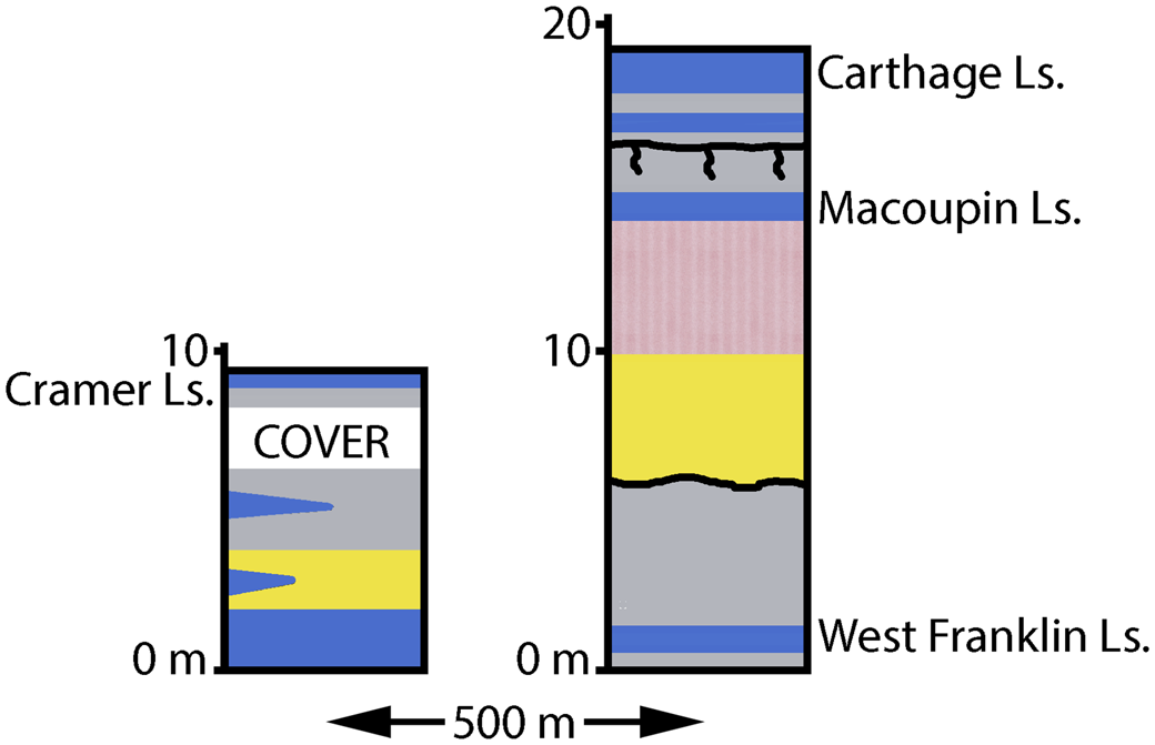
The lithostratigraphy and age of the deposit were unsettled for over half a century, with initial assignments to Permian and even Triassic (Collett, Reference Collett1876). It was not until the 1930s, when Romer referenced the unpublished fieldwork of J.M. Weller and H.R. Wanless, that the locality was authoritatively placed in the Pennsylvanian-aged McLeansboro Formation (Romer and Smith, Reference Romer and Smith1934). A few months later, Romer (Reference Romer1935, p. 1636) added that Wanless had presented a paper—“The age of the so-called Permian beds near Danville, Illinois”—at a 1934 meeting of the Illinois State Academy of Science. Although the paper was never published, the 1931 field notes of Wanless in Vermilion County (ISGS open files) are an integral part of the present report. The lithostratigraphy of the Horseshoe Bend area, based upon the findings reported below and current ISGS nomenclature, is shown in Figure 2.
Stratigraphic interval discussed in this paper based mainly upon a continuous core (Material Service F-72-B; see Fig. 5 for location). B = level of bonebed in paleochannel (Inglefield Sandstone) below Macoupin Limestone.

The Horseshoe Bend vertebrate assemblage itself also has a checkered history in the literature. After Cope's early papers, none of which included specimen numbers or adequate illustrations, Case (Reference Case1900) published a review of the assemblage, quoting Cope's original descriptions and adding his own comments on specimens that Cope had not seen. More importantly, Case (Reference Case1900) provided specimen numbers and five plates, 39% of which were based upon then-unpublished lithographs that had been prepared under Cope's direction. The original Cope lithographs were later published (Cope and Matthew, Reference Cope and Matthew1915) and are of much higher quality than the retouched copies of Case (Reference Case1900). When Case published monographs on ‘pelycosaurs’ and ‘cotylosaurs’ that included Danville material (Case, Reference Case1907, Reference Case1911b), some of the specimens were reillustrated and are also of better quality. The same applies to figures of fish specimens that appear in the work of Hussakof (Reference Hussakof1911).
By far, the most complete treatment of a Horseshoe Bend vertebrate taxon was provided by Romer and Price (Reference Romer and Price1940), who redescribed Clepsydrops Cope, Reference Cope1875, a primitive synapsid ‘pelycosaur’ that is the most common taxon in the collection (see below). Later studies based mainly upon Lower Permian specimens from North-Central Texas required the taxonomic adjudication of genera known from isolated elements from the bonebed (Holmes, Reference Holmes1989; Wellstead, Reference Wellstead1991). The only reports of the Danville assemblage in the past 40 years are literature-based surveys of Permo-Carboniferous vertebrate occurrences that focused mainly upon tetrapods (Carroll, Reference Carroll1984; Olson, Reference Olson1985; Kissel and Reisz, Reference Kissel, Reisz, Arratia, Wilson and Cloutier2004; Pardo et al., Reference Pardo, Small, Milner and Huttenlocker2019; Lucas, Reference Lucas2022).
Geology
Data and methods
In addition to measured sections from the Horseshoe Bend area held by the ISGS and field observations reported in the early literature, subsurface data were used to determine the stratigraphic position of the vertebrate deposit. The Danville Coal, which is 1.5–2.0 m thick in the area and once a prime target of exploration and mining, is the initial basis for correlations. Logs of coal-test boreholes near Horseshoe Bend were used to map the elevation of the top of the coal and determine its approximate position in the subsurface below one of Wanless’ 1931 sections (Stop 9 of Langenheim et al., Reference Langenheim, Mann and Beresky1980) (Figs. 1, 3). Whereas most of the boreholes on the structure map are generalized drillers’ logs, three higher resolution logs (Kerr-McGee #13-23-1, Gulf Oil #C-15-2C, Gulf Oil #C-27-2C; Fig. 1) occur within the map area and enable the identification of variegated claystone and limestone beds comparable to those of Horseshoe Bend. In addition, a geophysical log that includes gamma-ray, density, and resistivity tracks is available for Gulf Oil #C-15-2C (Fig. 4). This key log shows several thin zones of very high natural radioactivity on the upper part of the log. These represent organic- and phosphate-rich marine shales that are among the most reliable marker beds for lithostratigraphic correlations in the Illinois Basin. A larger area was studied to construct a roughly southwest-northeast cross section that includes the Stop 9 section as its northeastern terminus (Fig. 5). The southern endpoint of the section is another important record, a 94.6 m continuous core (Materials Service #F-72-8, drilled in Sec. 21, T18N, R13W, Vermilion County, ISGS county number 1837) that was logged by ISGS geologists and resides in the ISGS Samples Library collection under core storage number C-10248 (Fig. 2).
Stratigraphic sections measured by H.R. Wanless in 1931 southeast of the Horseshoe Bend bonebed (ISGS open-file records) and featured by Langenheim et al. (Reference Langenheim, Mann and Beresky1980): (left) Stop 8; (right) Stop 9. See Figure 1 for locations, Figure 2 for lithologic key.


Lithostratigraphic correlations of Danville Coal to Carthage Limestone interval from Materials Service F-72-8 core to Stop 9 outcrop. Position of Danville Coal below Stop 9 outcrop based upon structural mapping. Horizontal not to scale. Map inset shows locations. See Figure 2 for lithologic key. B = level of bonebed in paleochannel (Inglefield Sandstone) below Macoupin Limestone on Horseshoe Bend.

Outcrop data
Olson (Reference Olson1946) noted uncertainty over the fossiliferous rock type at Horseshoe Bend. Cope (Reference Cope1875, p. 404) stated that the initial Winslow specimens were preserved in a “blackish shale.” Later, however, Cope (Reference Cope1877b) reported that Winslow identified the deposit as No. 15 of F.H. Bradley's stratigraphic column for Vermilion County (Bradley, Reference Bradley1870, p. 245, 249). Bradley's No. 15 was described as 8–40 ft (2.4–12.2 m) of generally green and red shale with bands of concretionary argillaceous limestone that contained brackish to marine invertebrates. Bradley also noted that “the best locality is about eighty rods [402 m] below [downstream of] Major's mill, on the north bank of the Oxbow bend.” A period atlas of Vermilion County townships (Bowman, Reference Bowman1867) shows the mill, which confirms Bradley's location of the fossiliferous exposure along the northern side of the meander loop as reported above (Fig. 1).
The bonebed was described by Collett (Reference Collett1876, p. 256) in a note buried in his geological report on Vanderburg County, Indiana, an area > 200 km south of Vermilion County, Illinois: the fossils “occur in a bed of black, brown, gray, red and pink shales, backed with sandstone, filling a depression.” Although generalized, these observations agree with two unpublished sketches of the exposure. The first, from a 13 August 1875 letter from Winslow to Gurley (Gurley Papers, Box 5, Folder 1), depicts the bonebed as saucer-shaped in profile and below trees, brush, and the collectors’ camp at the top of the bluff (Fig. 6.1). In the accompanying letter, Winslow wrote: “The bone bed is about 75 feet [23 m] in length and crops along the bluff with the fragments scattered very unevenly through the bed.” The second sketch (Fig. 6.2), which is archived with Winslow's letters to Yale (Marsh Papers, MS 343), lacks scale but is more informative geologically. It unquestionably depicts a paleochannel that truncates underlying beds. The bonebed overlies sandstone, which is sketched with a series of subparallel wavy lines that suggest lateral accretion bedding within the U-shaped channel that is overlain by “Red clay & pink shales.” The latter sketch is attributed to Marsh, but it is not in his distinctive hand, and there is no record of him visiting the locality. Irrespective of its origin, the drawing complements Collett's Reference Collett1876 description, Winslow's 1875 sketch, and other data discussed below.
Field sketches of bonebed on Horseshoe Bend cutbank, Salt Fork of the Vermilion River. See Figure 1 for location: (1) by J.C. Winslow, in pen on lined, white paper, from letter to W.F.E. Gurley dated 13 August 1876 (W.F.E. Gurley Papers, Box 5, Folder 1, Hanna Holborn Gray Special Collections, University of Chicago Library); horizontal line at bottom labeled ‘salt fork level’; label above bold line reads, ‘Bonebed’; (2) undated pencil sketch on brown paper attributed to O.C. Marsh by unknown source; see text for discussion (Othniel Charles Marsh Paper, MS 343, Box 35, Folder 1537, Yale University Library Digital Collections).

The variability of lithologies (blackish to gray to greenish-red shale to soft clay), the presence of brackish to marine invertebrates, and the mixed nature of the vertebrate assemblage strongly suggest a commingling of samples acquired by Winslow, Collett, Gurley, Gibson, and perhaps others. Whereas the tetrapods might well have come from a variegated mudstone, it is possible that the brackish to marine sharks (known only from a small number of teeth and fragmentary spines) are from other beds in the same cutbank.
Of the two exposures near Horseshoe Bend measured by Wanless in 1931 and featured many years later by Langenheim et al. (Reference Langenheim, Mann and Beresky1980, Stop 9), on the southern bank of the Salt Fork, ~1.5 km southeast of the Horseshoe Bend locality (Figs. 1, 3), is the more complete. It includes 2.87 m of reddish to brownish-gray, slicken-sided claystone, of which Wanless remarked is “probably horizon of the so-called Permian reptiles from north side of Horseshoe Bend.” This section also includes the West Franklin Limestone near the base and two limestone beds overlying the variegated claystone. As detailed below, these units, combined with the underlying Danville Coal and other subsurface data, are the basis for local correlations and refined lithostratigraphic and age assignments for the Horseshoe Bend site.
Subsurface results and correlations
Structural contours on the top of the Danville Coal agree with similar mapping done on the county scale (Louchios et al., Reference Louchios, Elrick, Korose and Morse2009) and show that the coal dips westward and lies at an elevation of ~475 ft [145 m] below Stop 9 (Fig. 1). Correlations between the two high-quality subsurface records closest to Horseshoe Bend, Kerr-McGee #13-23-1 and Gulf Oil #C-15-2C, show that limestones overlie all three radioactive shales seen in the upper part of the geophysical log of the latter hole (Fig. 4), a stratigraphic relationship common in the Illinois Basin. Furthermore, some of the variegated claystone intervals also correlate between these two logs and others shown in Figure 5.
The stratigraphic interval of the cross section (Fig. 5) includes parts of the Shelburn, Patoka, and Bond formations and extends from the Danville Coal upward to the highest limestone bed exposed at Stop 9 (Figs. 2, 6). Overlying the Danville Coal is the Farmington Shale Member, a 17–20 m thick, medium to dark gray, partly silty to sandy shale that contains numerous bands and nodules of siderite. The lower part of the unit coarsens upward, and the base typically contains thin, dark gray to black, pyritic shale that contains marine invertebrates. An ~3 m thick, variegated claystone known informally as the Maria Creek mudstone overlies the Farmington Shale. Named for exposures in southwestern Indiana and traceable across large areas of the Illinois Basin, the Maria Creek represents one or more paleosols. The West Franklin Limestone overlies this claystone and is the lowest unit identified on outcrops in the Horseshoe Bend area. Although this limestone commonly exceeds 5 m in thickness in the southeastern part of the Illinois Basin, it is generally thin and discontinuous in the Danville area. Whereas the West Franklin can be recognized in the Materials Service core and on outcrops at Stops 8 and 9, it is absent in several other well logs used in this study (Fig. 5).
The upper part of the cross section shows a succession of three limestone beds separated by strata that include gray shale, variegated claystone, organic-rich radioactive shales, and local thin coal (Fig. 5). A comparison of this cross section to a larger network of subsurface cross sections in the Illinois Basin (unpublished data, W.J. Nelson, 2007–present) supports the following correlations, in descending order: (1) the upper limestone is the Carthage Limestone Member at the base of the Bond Formation, (2) the middle limestone is the Macoupin Limestone Member of the Patoka Formation, and (3) the lower limestone is the Cramer Limestone Member of the Patoka Formation. It follows that the terrestrial vertebrates found in variegated mudstone at Horseshoe Bend occurred below the Macoupin Limestone of the Patoka Formation.
In summary, the bonebed lies within a small paleochannel associated with the Inglefield Sandstone Member of the Patoka Formation (Fig. 2). First described near Evansville, Indiana (Fuller and Ashley, Reference Fuller and Ashley1902), the Inglefield Sandstone has been mapped widely in southern Illinois (Andresen, Reference Andresen1961) and occurs extensively in southwestern Indiana (Shaver et al., Reference Shaver, Ault, Burger, Carr and Droste1986). The sandstone ranges from 0–~25 m thick in the interval between the Cramer and Macoupin Limestones, locally truncating the former. Subsurface mapping and paleocurrent data suggest a dendritic, meandering fluvial system in which the trunk stream flowed south-southwest across southeastern Illinois (Andresen, Reference Andresen1961). At a locality in southern Illinois, a paleochannel correlated with the Inglefield contains low-sulfur coal and abundant plant fossils, dominantly pteridosperms (DiMichele et al., Reference DiMichele, Eble, Nelson, Pfefferkorn and Elrick2023).
Vertebrate paleontology
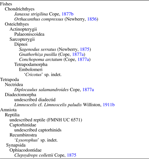
Table 1 lists the vertebrates currently recognized from the Horseshoe Bend deposit. The following provides updated taxonomic notes on the assemblage based upon the literature and study of the collection at the FMNH, which holds nearly all of the vertebrate material known from the site. Approximately 960 specimens have been determined and cataloged, and an additional sample of at least 500 fragments accompany the cataloged material. As noted below, study of these fragments will enrich our understanding of the assemblage.
Horseshoe Bend vertebrate taxa.

Fishes
At least one fish taxon described by Cope from Horseshoe Bend is unquestionably marine. The petalodont shark Janassa strigilina Cope, Reference Cope1877b, is known from only two teeth, but the genus is otherwise well known from more complete specimens from other localities (Hansen, Reference Hansen1985). Olson (Reference Olson1946) synonymized Cope's two species of Janassa Münster, Reference Münster1839, so that there is only one petalodont shark from Horseshoe Bend. Although the batoid-like Janassa has a long range and wide geographic distribution, it has always been regarded as a marine form with the exception of a misidentified fragment from a freshwater deposit in the Czech Republic (Zidek, Reference Zidek1967; Štamberg, Reference Štamberg2013). It is almost certain that these isolated Janassa teeth did not come from Cope's ‘Clepsydrops shale’ and occurred instead in the marine mudstones or limestones once exposed on the cutbank.
Xenacanth sharks are represented in the Horseshoe Bend collection by a few (< 10) incomplete teeth and occipital spine fragments. Teeth were mentioned first as Diplodus ?compressus (Cope, Reference Cope1877b) and best figured by Cope and Matthew (Reference Cope and Matthew1915, pl. 3, figs. 2–4), but the material has never been described. The correct binomen is Orthacanthus compressus (Newberry, Reference Newberry1856), one of the more common fossils at the slightly older deposit of Linton, Ohio. Cope reported two spine species but described only Orthacanthus quadriseriatus Cope, Reference Cope1877a; the undescribed species was referred to a Linton taxon, Orthacanthus gracilis Newberry, Reference Newberry1875, in lists of supposed Permian forms (Cope, Reference Cope1881, Reference Cope1883b). The figured spine fragments (FMNH UC 6502, 6503) from Horseshoe Bend (Hussakof, Reference Hussakof1911, pl. 26, figs. 3, 4; Cope and Matthew, Reference Cope and Matthew1915, pl. 3, fig. 1, 1a) differ but fall within the range of variation found in more complete single spines known from other Permo-Carboniferous localities (e.g., Soler-Gijón, Reference Soler-Gijón1995, Reference Soler-Gijón1999; Beck et al., Reference Beck, Soler-Gijón, Carlucci and Willis2016). If further study confirms this observation, the senior name is Orthacanthus gracilis for cephalic spine specimens in this collection. In addition to xenacanth teeth and spines, several small heteropolar spiral coprolites are in the Horseshoe Bend collection (FMNH UC 6574; Case, Reference Case1900; Cope and Matthew, Reference Cope and Matthew1915, pl. 3, fig. 50). These are similar to coprolites found in association with xenacanth remains elsewhere and, therefore, probably pertain to Orthacanthus Agassiz, Reference Agassiz1833.
Although palaeoniscoids have been included in summaries of the Horseshoe Bend assemblage (Olson, Reference Olson1946, Reference Olson1985; DeMar, Reference DeMar1980), these records appear to be based upon prior misinterpretations of lungfish material (see below) or possibly the inclusion of Platysomus Agassiz, Reference Agassiz1833, in a table that compared the supposedly Permian-aged fish genera known from Bohemia, Texas, and Illinois (Hussakof, Reference Hussakof1911, p. 175). In fact, neither Cope nor Case reported platysomids from Horseshoe Bend, and Hussakof (Reference Hussakof1911) provided no documentation. Study of the FMNH collections confirms a single palaeoniscoid fragment that has unornamented, rhombic scales (FMNH UF 571). Aside from this lone specimen, a few indeterminant scale fragments were found in the uncataloged material. Thus, palaeoniscoids are exceedingly rare in the collection.
Cope greatly inflated the taxonomic diversity of lungfish from Horseshoe Bend, all represented by fragmentary mandibular and palatal tooth plates. In a series of papers, he introduced seven species of Ceratodus Agassiz, Reference Agassiz1838, or Ctenodus (Ceratodus vinslovii; Ceratodus paucicristatus Cope, Reference Cope1877b, Ctenodus fossatus Cope, Reference Cope1877b, Ctenodus gurleyanus Cope, Reference Cope1877b; Ctenodus pusillus Cope, Reference Cope1877a; Ctenodus heterolophus Cope, Reference Cope1883a, Ctenodus vabasensis Cope, Reference Cope1883b). Most of Cope's types have been figured reasonably well (Hussakof, Reference Hussakof1911, pl. 26, fig. 11, pl. 27, figs. 4, 7, 10; Cope and Matthew, Reference Cope and Matthew1915, pl. 3, figs. 6–10). In the first specimen-based revision of this material, Hussakof (Reference Hussakof1911) assigned the type of Ctenodus pusillus, a palatal tooth fragment (FMNH UC 6508), to the distinctive lungfish genus Gnathorhiza Cope, Reference Cope1883a, as G. pusilla (Cope, Reference Cope1877a) and recognized the remaining six species as Sagenodus Owen, Reference Owen1867, following Woodward (Reference Woodward1891), who was the first to clarify the differences between Ctenodus and Sagenodus based mainly upon teeth in European collections. After noting that one of Cope's types was lost, Hussakof synonymized three of the original species, which reduced the Sagenodus species count to three. Romer and Smith (Reference Romer and Smith1934) placed two of these species into Sagenodus serratus (Newberry, Reference Newberry1875), which left the poorly preserved type of Sagenodus paucicristatus Cope, Reference Cope1877b, as a second species. In the most recent comprehensive study of North American Sagenodus material, Schultze and Chorn (Reference Schultze and Chorn1997) regarded the incomplete and poorly preserved type of Sagenodus paucicristatus as a nomen dubium and recognized only one species of Sagenodus in the Horseshoe Bend collections, namely Sagenodus serratus, the most common lungfish at Linton and Five Points, Ohio (Hook and Baird, Reference Hook and Baird1986, Reference Hook and Baird1993).
The third Horseshoe Bend dipnoan, Conchopoma arctatum (Cope, Reference Cope1877a), had a twisted history in the literature as a crossopterygian, a reptile, a cotylosaur, and an actinopterygian before it was correctly identified (Denison, Reference Denison1969, Reference Denison1974) and redescribed (Schultze, Reference Schultze1975) as a lungfish. Both the type (FMNH UC 6511) and a referred specimen (FMNH UC 6512) are small but distinctive basihyal tooth plates (Hussakof, Reference Hussakof1911, pl. 31, figs. 1, 2; Cope and Matthew, Reference Cope and Matthew1915, pl. 3, fig. 5). Hussakof (Reference Hussakof1911) erroneously referred these specimens to the palaeoniscoid Sphaerolepis Fritsch, Reference Fritsch1877, an interpretation followed by Olson (Reference Olson1946).
Tetrapods
Cope described three genera from Horseshoe Bend based upon isolated vertebrae of forms that were similar to specimens collected subsequently from the Lower Permian of North-Central Texas. Although the Texas discoveries were far more complete, the scant Illinois records have priority and necessitated critical assessment in the late 1980s as monographic works on various groups progressed. The first of these problematic taxa was the first vertebrate described from Horseshoe Bend, Cricotus heteroclitus. Cope later added Cricotus gibsonii Cope, Reference Cope1877a, and Cricotus discophorus Cope, Reference Cope1877a, likewise based upon isolated centra from Danville (Case, Reference Case1900, pl. 1, figs. 12–15). When comparable embolomerous vertebrae were found in the Lower Permian of North-Central Texas, Cope introduced additional Cricotus species, and for many years the genus was considered Permian and common to both Illinois and Texas. Although Case (Reference Case1915) described a new amphibian genus, Archeria Case, Reference Case1915, from Texas that would accommodate all of the Texan Cricotus species of Cope, many years would pass before this was accepted fully (see Romer, Reference Romer1945, p. 424 footnote). In the original description of Cricotus heteroclitus, Cope (Reference Cope1875) mentioned, but did not detail, an unspecified number of limb bones, an association that Case (Reference Case1911a) dismissed. Case (Reference Case1900, pl. 5, figs. 13–16) himself, however, described and figured several phalanges (FMNH UC 6523) that resemble those figured subsequently by Romer (Reference Romer1957, figs. 2, 15) for Archeria. As part of his comprehensive study of Archeria, Holmes (Reference Holmes1989, p. 165) reviewed the status of the Cricotus type material from Illinois and concluded: “There is now little doubt that none of the Danville specimens are diagnostic despite all attempts to validate the genus Cricotus.” Thus, the genus is a nomen dubium, but the material clearly represents an embolomerous amphibian.
Diplocaulus Cope, Reference Cope1877a, is the second genus based upon isolated vertebrae from Horseshoe Bend that was eclipsed by more complete remains from the Lower Permian of Texas (Diplocaulus magnicornis Cope, Reference Cope1882). Studies of the Texas species have allowed the Illinois species, Diplocaulus salamandroides Cope, Reference Cope1877a, to stand because of proportional size differences (Douthitt, Reference Douthitt1917) and stratigraphic criteria (Olson, Reference Olson1951; Milner, Reference Milner, Carroll, Bossy, Milner, Andrews and Wellstead1998). In addition to the Diplocaulus vertebrae illustrated from Horseshoe Bend (Case, Reference Case1900, pl. 1, figs. 16, 17, pl. 5, fig. 17; Cope and Matthew, Reference Cope and Matthew1915, pl. 3, figs. 21–23), Case (Reference Case1900) mentioned a collection of finely sculptured skull fragments that he regarded as probable Diplocaulus remains (see Cope and Matthew, Reference Cope and Matthew1915, pl. 3, fig. 18). Study of both cataloged and uncataloged material indicate ~70 diplocaulid fragments, mostly cranial, derived from several individuals. These specimens encourage a re-examination of Diplocaulus salamandroides based on cranial, not vertebral, characters.
The last of the uncertain names based upon isolated vertebrae from Horseshoe Bend is Lysorophus tricarinatus Cope, Reference Cope1877a. This material was redescribed and illustrated by Wellstead (Reference Wellstead1991, figs. 28, 29), who concluded that the genus is incertae sedis within the Lysorophia. More recently, ‘lysorophians’ or molgophids have been regarded as members of Recumbirostra, a clade of fossorially adapted early reptiles (Pardo et al., Reference Pardo, Szostakiwskyj, Ahlberg and Anderson2017; Mann et al., Reference Mann, Pardo and Maddin2019b, Reference Mann, Pardo and Sues2022).
Two diadectomorphs are present in the collection, but they have been omitted from most summaries of the assemblage and from nearly all diadectomorph studies. Cope (Reference Cope1883b) noted and Case (Reference Case1900, pl. 5, fig. 23a, b) figured an isolated diadectid incisor (FMNH UC 6569; Fig. 7.1). A second diadectomorph, Limnoscelis Williston, Reference Williston1911b, is represented by a partial right humerus that was figured by Case (Reference Case1900, pl. 3, fig 4; FMNH UC 6541; Fig. 8.1), as well as a partial right ulna that is likely from the same individual. Whereas Case (Reference Case1900) did not identify FMNH UC 6541, Williston (Reference Williston1910) referred it to Desmospondylus anomalus Williston, Reference Williston1910, the type of which is from the Lower Permian of Texas. Unfortunately, in his subsequent review of the Cotylosauria, Case (Reference Case1911b, pl. 11, figs. 4, 5) mistakenly cited the Illinois specimen as the type of Williston's Desmospondylus Williston, Reference Williston1910. At nearly the same time, however, Williston (Reference Williston1911a) correctly synonymized the actual type (Desmospondylus anomalus from Texas) with Seymouria baylorensis Broili, Reference Broili1904, but did not comment on the Horseshoe Bend material. After it languished for > 50 years, Vaughn (Reference Vaughn1969, p. 22) regarded the specimen as a ‘limnosceloid,’ and Carroll (Reference Carroll1984) found it indistinguishable from Limnoscelis paludis Williston, Reference Williston1911b, from the Permo-Carboniferous of El Cobre Canyon, Rio Arriba County, New Mexico. Preliminary observations of uncataloged Horseshoe Bend material at the FMNH suggest that there are more specimens attributable to diadectomorphs.
Horseshoe Bend vertebrates: (1) diadectid incisor, lateral (left) and lingual (right) views (FMNH UC 6569); (2) captorhinid right dentary fragment, occlusal (left) and lateral (right) views (FMNH UC 414); (3) captorhinid maxilla fragment, occlusal view (left) and lateral (right) views (FMNH UC 420); (4) Clepsydrops anterior dentary fragment, lateral (left) and medial (right) views (FMNH UC 6525); (5) Clepsydrops maxillary fragment, right caniniform region in lateral aspect (FMNH UC 6525); (6) Clepsydrops maxillary fragment, FMNH UC 6524, holotype of Archaeobelus vellicatus Cope, Reference Cope1877a; (7) Clepsydrops articulated premaxillae in anterior view (FMNH UC 6536); (8) Clepsydrops left stapes in anterior perspective (FMNH UR 329); (9) Clepsydrops left squamosal in lateral aspect (left) and medial aspect (right) (FMNH UR 2785). c = canine; dp = dorsal process; fp = footplate of stapes; eltf = emargination for lower temporal fenestra; etf = emargination for temporal fenestra; s = symphysis.

Horseshoe Bend vertebrates: (1) Limnoscelis cf. Limnoscelis paludis Williston, Reference Williston1911b, right humerus in distal ventral aspect (left; reconstructed parts in buff-colored plaster) and right ulna in dorsal aspect (right) (FMNH UC 6541), presumed to represent the same individual; (2) partial reptile mandibles in lateral (top) and medial (bottom) views (FMNH UC 6571). delt = deltopectoral crest; ent for = entepicondylar foramen; ole = olecranon process of the ulna.

Another overlooked aspect of the Danville tetrapod assemblage is the diversity of reptiles from the site. Of particular significance is a probable early reptile noted by Case (Reference Case1900, p. 721): “A lower jaw, nearly complete, resembles very closely that of Pariotichus from Texas … The outer side is marked by strong reticulate sculpture …” Case's concept of Pariotichus Cope, Reference Cope1878, was that of a captorhinid rather than what is known today as the gymnarthrid ‘microsaur’ Pariotichus brachyops Cope, Reference Cope1878 (for taxonomic details, see Carroll and Gaskill, Reference Carroll and Gaskill1978; Heaton, Reference Heaton1979). Case did not provide any illustrations or measurements, only a specimen number (FMNH UC 6571) which currently consists of five individual partial mandibles that likely represent the same taxon. The most complete of these is missing the anteriormost part of the jaw and no longer preserves exposed teeth (Fig. 8.2). Computed tomography (CT) scan data reveal a slightly dislodged, denticulated posterior coronoid. Whereas denticulated coronoids are unknown in any captorhinid or basal eureptile, they occur in the Lower Permian acleistorhinid parareptile Delorhynchus Fox, Reference Fox1962 (Haridy et al., Reference Haridy, MacDougall and Reisz2018). Therefore, it is possible that FMNH UC 6571 represents an early acleistorhinid. This occurrence predates the bolosaurid parareptile Erpetonyx arsenaultorum Modesto et al., Reference Modesto, Scott, MacDougall, Sues, Evans and Reisz2015, which was reported from the Gzhelian of Prince Edward Island, Canada, with only the most rudimentary provenance data. FMNH UC 6571 is still younger than the oldest known parareptile, the acleistorhinid Carbonodraco lundi Mann et al., Reference Mann, McDaniel, McColville and Maddin2019a, from the Moscovian of Linton, Ohio. Because further analysis of FMNH UC 6571 is required, it is presented in Table 1 as an indeterminate reptile.
In addition to FMNH UC 6571, study of the FMNH collection revealed two smaller jaw fragments—FMNH UC 414, a likely right dentary fragment (Fig. 7.2), and FMNH UC 420, a partial right maxillary fragment (Fig. 7.3)—which likely represent captorhinid reptiles. FMNH UC 414 is ~8 mm long, and its lateral and medial surfaces are either unprepared or not preserved; the well-preserved occlusal surface, however, bears marginal dentition and shows the characteristic laterally sweeping row of teeth associated with the anterior end of most captorhinid dentaries (e.g., Captorhinus aguti Cope, Reference Cope1882; Fox and Bowman, Reference Fox and Bowman1966). The teeth slightly increase in size posteriorly. The posteriormost preserved end of the jaw fragment shows the beginning of the multiple tooth row, with a larger worn tooth base visible medially, similar to that observed in the Lower Permian captorhinid Captorhinus aguti. FMNH UC 420, a right maxillary fragment (5 mm long), preserves the posterior end of a maxilla alongside three broken tooth bases. The lateral surface on this specimen is well preserved and shows fine ridges that resemble the ornamentation found on some specimens of the supposed captorhinid Opisthodontosaurus Reisz et al., Reference Reisz, LeBlanc, Sidor, Scott and May2015 (Carroll and Gaskill, Reference Carroll and Gaskill1978, fig. 40; Reisz et al., Reference Reisz, LeBlanc, Sidor, Scott and May2015); however, this light ornamentation might also reflect a juvenile condition. Approximately four tooth bases are preserved, with the anterior two located adjacent to each other indicating the presence of a multiple tooth row. It is possible both FMNH UC 420 and FMNH UC 414 represent the same multiple-tooth rowed captorhinid species or even belong to the same individual. Further processing of uncataloged materials at the FMNH could provide a more complete understanding of this taxon. The captorhinid material from Danville awaits detailed study because it predates Euconcordia cunninghami Müller and Reisz, Reference Müller and Reisz2005, from the Gzhelian of Kansas (Fig. 9), which is currently regarded as the oldest known captorhinid (Reisz et al., Reference Reisz, Haridy and Müller2016).
Major late Carboniferous terrestrial vertebrate localities of North America and associated records of higher taxa. Question mark [?] after Howard locality denotes lack of nonvertebrate criteria for age determination; see text for discussion. CO = Colorado; KS = Kansas; IL = Illinois; NM = New Mexico; NS = Nova Scotia, Canada; OK = Oklahoma; OH = Ohio; UT = Utah.

The second tetrapod described from Horseshoe Bend was Clepsydrops collettii. Because the genus Clepsydrops is being studied by the senior author and collaborators, and because the Danville material has been figured in the literature as noted below, our illustrations are limited to Figure 7. As in the case of other genera that Cope (Reference Cope1875) first reported from the locality (Cricotus Cope, Reference Cope1875, Lysorophus Cope, Reference Cope1877a, Diplocaulus), Cope (Reference Cope1877a) later used the name Clepsydrops for a number of somewhat similar ‘pelycosaurs’ from the Lower Permian of Texas. Romer and Price (Reference Romer and Price1940) corrected these assignments and gave considerable attention to the Illinois material because, at the time, it represented the oldest known synapsid material (Romer, Reference Romer1935, Reference Romer1936). In redescribing the genus, Romer and Price (Reference Romer and Price1940, p. 213) estimated that 75% of all of the fossils from the deposit was “definitely pelycosaurian.” They maintained two of Cope's species, Clepsydrops collettii and Clepsydrops vinslovii, for comparatively large and small forms, respectively. This was uncharacteristic of Romer, who, in the same monograph (Romer and Price, Reference Romer and Price1940, p. 10), quoted from an earlier paper (Romer and Smith, Reference Romer and Smith1934, p. 704) his approach to species identification: “… if, from a given horizon and region, one species of a genus has been described, no further species of that genus should be named unless the specimens found exhibit one or more characteristics which might reasonably be expected to distinguish them from the first; and that if in the absence of presumably valid differences, further species are named, they should be regarded as synonyms of that first described from the horizon and locality.” It is likely that ongoing study of the entire Clepsydrops sample will show that only one synapsid occurs at Danville, namely Clepsydrops collettii. Thus, Ceratodus vinslovii is not included in Table 1.
Based mainly upon postcranial material (some figured by Case, Reference Case1900, Reference Case1907; Cope and Matthew, Reference Cope and Matthew1915; Romer and Price, Reference Romer and Price1940), Romer and Price (Reference Romer and Price1940) regarded Clepsydrops as an ophiacodontid closer to Varanosaurus Broili, Reference Broili1904, than to Ophiacodon Marsh, Reference Marsh1878. Laurin and Buffrénil (Reference Laurin and de Buffrénil2016) concluded that this Clepsydrops was a fully terrestrial form after histological study of a single femur. Recent phylogenetic studies of early synapsids have not included Clepsydrops. Although cranial material of Clepsydrops is fragmentary and rare, incomplete maxillae described as Archaeobelus vellicatus Cope, Reference Cope1877a (FMNH UC 6524; Cope and Matthew, Reference Cope and Matthew1915, pl. 3, fig. 13–13c; Fig. 7.5, 7.6) were synonymized with Clepsydrops collettii by Romer and Price (Reference Romer and Price1940) because they were of the appropriate size and possessed an ascending medial buttress, as found in other ophiacodontids.
Other cranial material attributable to Clepsydrops includes an articulating pair of premaxillae (FMNH UC 6536; Fig. 7.7), the anterior end of a left dentary (FMNH UC 6525; Fig. 7.4), a robust right stapes (FMNH UC 329; Fig. 7.8), and 13 basioccipitals of varying sizes (FMNH UC 6537, FMNH UR 3025–3037). The last are of particular significance because they provide a minimum number of Clepsydrops individuals from the site and confirm a size continuum, rather than a large and a small species as maintained by Cope, within the Clepsydrops sample. Furthermore, formerly uncataloged remains at the FMNH include cranial material of Clepsydrops (e.g., Fig. 7.9) which will be detailed in a full redescription of the genus.
For the sake of completeness, we note that a well-preserved left femur from Horseshoe Bend was the basis for Captorhinus illinoisensis Williston, Reference Williston1911a. Romer and Price (Reference Romer and Price1940, pl. 43E–J) placed this in Clepsydrops. Although Bruner (Reference Bruner1991) reported the specimen (FMNH UC 6548) as missing, it is currently housed in the type collection of the FMNH.
Discussion
Taphonomy
Whereas the Horseshoe Bend deposit might be lost, some basic taphonomic conclusions can be made. At the time of initial collecting by Winslow and subsequent work by Gurley soon thereafter, the technique of extracting vertebrate fossils in an intact manner by applying plaster bandages was unknown (see Whybrow, Reference Whybrow1985). Because the majority of tetrapod bones are unabraded and with fresh breaks, it is likely that the deposit contained far more complete specimens than suggested by the existing collection of highly fragmentary remains. In particular, it appears that some of the Clepsydrops appendicular and axial material might come from articulated individuals. Only one short, articulated vertebral segment exists in the FMNH collection (five vertebrae, FMNH UR 2786).
Even though most specimens from Horseshoe Bend suggest a minimum of postmortem exposure or transport, a few tetrapod bones have modest pedogenic crusts, and others occur as densely packed fragments in a silt to very fine-grained sand matrix. These examples, which are too few to characterize taxonomically, support a bonebed interpretation for at least part of the fossiliferous cutbank.
In discussing Danville tetrapods, Case (Reference Case1900, p. 716, 717) emphasized “the absence of animals of any great size as compared with the Texas forms.” This is correct only in the context of the Permian Clear Fork and underlying upper Wichita vertebrate assemblages with which, at the time, he was most familiar. Subsequent work in the lower Wichita and underlying Bowie Groups (Permian) of Texas by Case and others did not yield the large diadectids, captorhinids, and synapsids typical of the younger rocks. In fact, the largest specimens from Horseshoe Bend are comparable in size to those from roughly coeval Permo-Carboniferous sites in Ohio, Texas, Oklahoma, and the Southwest.
Paleoenvironmental setting and age of the vertebrate assemblage
The depositional history of the fossiliferous cutbank on Horseshoe Bend can be reconstructed from period field sketches (Fig. 6) and nearby exposures measured by Wanless in 1931 (Fig. 3). The variegated slickensided mudstone below the Macoupin Limestone is in the upper part of an ~7.3 m thick, erosive-based, fining-upward channel deposit that appears to have cut out the Cramer Limestone Member (Figs. 3, 5). The occurrence of aquatic to terrestrial vertebrates in the mudstone interval suggests that it originated as a floodplain lake within an abandoned fluvial channel, one of the more common preservational modes for Permo-Carboniferous vertebrates (Hook and Ferm, Reference Hook and Ferm1988; Nelson et al., Reference Nelson, Hook and Chaney2013). As shown by the slickensided, multicolored nature of the claystone, the channel fill was subsequently overprinted by paleopedogenic processes as observed widely in coal-bearing rocks of the Illinois Basin (Rosenau et al., Reference Rosenau, Tabor, Elrick and Nelson2013).
The age of the Horseshoe Bend deposit is determinable even though there is no consensus on provincial Carboniferous time scales in the United States. In the Midcontinent, the boundary between the Desmoinesian (older) and Missourian (younger) provincial stages is currently defined as the top of the Exline Limestone Member on the basis of conodonts (Heckel et al., Reference Heckel, Boardman and Barrick2002). The Exline Limestone, also called Scottville Limestone Member, extends from the Midcontinent Basin into the western part of the Illinois Basin (Wanless, Reference Wanless1957; Willman et al., Reference Willman, Atherton, Buschbach, Collinson, Frye, Hopkins, Lineback and Simon1975). In turn, the Exline has been correlated to the upper of three benches of the West Franklin Limestone in the eastern part of the Illinois Basin (Manos, Reference Manos1963; King, Reference King1994; unpublished data [cross sections], W.J. Nelson, 2007–present). The top of the Missourian Stage is close to the Calhoun Coal Member in southeastern Illinois (Peppers, Reference Peppers1996), considerably above the youngest rocks of the Danville area. Accordingly, the age of the Danville vertebrate locality can be fixed as early Missourian, corresponding to early Kasimovian on the global Carboniferous time scale (Aretz et al., Reference Aretz, Herbig, Wang, Gradstein, Agterberg, Ogg, Gradstein, Ogg, Schmitz and Ogg2020).
The North American record of late Carboniferous tetrapods
Some of the findings of this paper and several other recent or ongoing studies of late Carboniferous tetrapod occurrences are summarized stratigraphically in Figure 9. This is not meant to be an exhaustive review of the record, rather a survey of the major localities, which are discussed below in ascending stratigraphic order.
The oldest locality shown is the Moscovian-aged cannel coal of Linton, Ohio, a benchmark deposit that has produced a diverse assemblage of fishes, amphibians, and amniotes, including the oldest known parareptile and edaphosaurid and ophiacodontid synapsids (Hook and Baird, Reference Hook and Baird1986; Mann et al., Reference Mann, McDaniel, McColville and Maddin2019a, Reference Mann, Hook and Pierce2023a, Reference Mann, Henrici, Sues and Pierceb). Although the tree-stump locality of Florence, Cape Breton Island, Nova Scotia, has been regarded traditionally as Westphalian (Moscovian) and possibly older than Linton, megafloral and palynologic data indicate a Stephanian or Cantabrian age (Zodrow, Reference Zodrow1986, Reference Zodrow1989, Reference Zodrow2006; Dimitrova et al., Reference Dimitrova, Zodrow, Cleal and Thomas2009, Reference Dimitrova, Cleal and Thomas2011; Dolby et al., Reference Dolby, Falcon-Lang and Gibling2011). The same applies to the varanopid synapsid from Point Aconi (Maddin et al., Reference Maddin, Mann and Herbert2020), which is ~6.5 km north-northwest of the Florence stump site and ~70 m higher in the section based upon published stratigraphic data (Bell, Reference Bell1938; Gibling et al., Reference Gibling, Saunders, Tibert and White2004). The recent dismissal of the Cantabrian Substage (Nelson et al., Reference Nelson, Lucas, Elrick, Lucas, DiMichele, Opluštil and Wang2023) does not change the fact that paleobotanical data from rocks associated with Cape Breton Island vertebrates are post-Moscovian.
Relative to Horseshoe Bend, which produced an unquestionable limnoscelid humerus (FMNH WM 6541, see above), Limnostygis relictus Carroll, Reference Carroll1967, from Florence was described as the oldest limnoscelid. Later study of the type and only specimen concluded that it is a mix of reptile vertebrae and an ophiacodontid maxilla and pectoral girdle (Wideman and Sumida, Reference Wideman and Sumida2004). Thus, Limnostygis relictus is a nomen dubium, and no limnoscelids occur at Florence (Wideman and Sumida, Reference Wideman and Sumida2004). The original descriptions of the two ophiacodontids known from Florence, Archaeothyris Reisz, Reference Reisz1972, and Echinerpeton Reisz, Reference Reisz1972, included almost no consideration of Clepsydrops from Horseshoe Bend and, particularly in the case of Archaeothyris, need revision (Mann and Paterson, Reference Mann and Paterson2019). In addition, the eureptile Paleothyris acadiana Carroll, Reference Carroll1969, known only from Florence, requires redescription because some of the paratypic specimens are not Paleothyris Carroll, Reference Carroll1969, and because this genus is critical to the standing of the protorothyridid reptiles, which Müller and Reisz (Reference Müller and Reisz2006) regarded as paraphyletic based upon their phylogenetic analysis. However, pending a redescription of Paleothyris and several other taxa, protorothyridids are not disqualified as paraphyletic or polyphyletic in this paper.
The Danville Coal is the basis for comparing the lithostratigraphic level of the Horseshoe Bend locality to that of the fossiliferous cannel below the Upper Freeport coal at Linton and younger vertebrate localities in the Ohio Valley. Paleobotanical and palynological data from both coals and their roof shales support an interbasinal correlation between the two seams (Peppers, Reference Peppers1996). As determined from subsurface mapping, the Horseshoe Bend deposit occurred ~38 m above the Danville Coal. When this estimate is applied to the Upper Freeport section at Linton, the result places the Vermilion County deposit in the Brush Creek interval of the Ohio Conemaugh Group. This part of the Ohio section is similar to the upper Patoka Formation of Illinois in that both contain well-developed multicolored paleosols, minor coal beds, and shallow marine carbonates.
Next in stratigraphic order is the Horseshoe Bend vertebrate assemblage itself, which as outlined above includes the oldest known diadectid and limnoscelid fossils, as well as a likely parareptile and captorhinid eureptile remains that are distinct from Permo-Carboniferous protorothyridids yet similar to those known from the Lower Permian. If further study confirms that the Horseshoe Bend specimens are captorhinid, they would be the oldest known, predating Euconcordia cunninghami from Hamilton, Kansas. Otherwise, the Horseshoe Bend tetrapod assemblage is broadly comparable to that of Linton in having a nectridean, a small embolomere (an unnamed archeriid from Linton and Five Points, Ohio; Holmes and Baird, Reference Holmes and Baird2011), a molgophid recumbirostran (Brachydectes Cope, Reference Cope1868, of Wellstead, Reference Wellstead1991), and the ophiacodontid Clepsydrops (Mann et al., Reference Mann, Hook and Pierce2023a).
At the remarkable locality of Garnett, Anderson County, Kansas, terrestrial plant remains, including palynomorphs, accompany the vertebrate assemblage. The collection was taken from the Rock Lake Shale Member of the Stanton Formation, which is latest Missourian (Winston, Reference Winston1983) or uppermost Kasimovian age and considerably younger than any rocks present in the Danville area. The deposit is regarded as a channel fill within a coastal plain setting and is renowned for the oldest known diapsid eureptile, Petrolacosaurus kansensis Lane, Reference Lane1945 (Reisz, Reference Reisz1981), and a number of synapsid ‘pelycosaurs,’ including an undescribed ophiacodontid that Peabody (Reference Peabody1957) regarded as Clepsydrops. Although no diadectid body fossils have been reported from Garnett, Ichniotherium Pohlig, Reference Pohlig1892 (= Megabaropus Baird, Reference Baird1952 of Reisz et al., Reference Reisz, Heaton and Pynn1982) trackways are present and almost certainly pertain to a large diadectid (Buckwitz and Voight, Reference Buckwitz and Voight2018). No unquestionable remains of embolomeres, nectrideans, molgophids, or limnoscelids have been reported from Garnett, which shares only an ophiacodontid and probable diadectid record with Horseshoe Bend.
The Howard locality of Fremont County, Colorado has also been called Badger Creek (Milner and Panchen, Reference Milner, Panchen, Tarling and Runcorn1973) and Salida (Olson, Reference Olson1985). By any name, it is the single most-diverse Kasimovian-Gzhelian tetrapod-bearing deposit in North America and was interpreted as a lake or part of an abandoned fluvial channel by Peter P. Vaughn, who excavated the site during seven field seasons between 1966 and 1973 (personal communication, A.C. Henrici, 2022; Vaughn, Reference Vaughn1969, Reference Vaughn1972). Because it is not associated with marine units or beds rich in megascopic plant fossils that might yield biostratigraphic data, we sent matrix samples from the Howard collection held by the Carnegie Museum of Natural History to C.F. Eble (Kentucky Geological Survey) for palynological analysis in 2022. This seemed promising because the matrix is a dark mudstone that appears to be organic rich, but the results were negative. Vitrinite reflectance measurements subsequently showed that the organics were at the rank of anthracite and beyond the thermal window of palynomorph recovery (calculated Ro max = 2.58%; personal communication, C.F. Eble, 6 April 2023). On the basis of its vertebrate assemblage, Howard has been regarded as Missourian and approximately the same age as Garnett because the two localities have a comparable synapsid record and because the diadectid Desmatodon Case, Reference Case1908, which could well have been the maker of Ichniotherium tracks at Garnett, occurs at Howard (Vaughn, Reference Vaughn1969, Reference Vaughn1972; Berman and Sumida, Reference Berman and Sumida1990, Reference Berman and Sumida1995; Sumida and Berman, Reference Sumida and Berman1993). However, given the presence of limnoscelid and diadectid material at both Howard and Horseshoe Bend, Howard could represent a Kasimovian record a few million years older than Garnett, closer to Horseshoe Bend.
From the 1970s to the early 1990s, a small area east of Hamilton, Greenwood County, Kansas received considerable attention because rare but well-preserved remains of terrestrial fossils (plant and animal), as well as aquatic vertebrates that ranged from freshwater to marine, were discovered in a series of small limestone quarries. Located ~82 km west-southwest of Garnett and ~200 m higher in the section, Hamilton, like Garnett, originated as a coastal-plain channel fill eroded into the Topeka Limestone (Cunningham et al., Reference Cunningham, Feldman, Franseen, Gastaldo, Mapes, Maples and Schultze1993; Salley et al., Reference Salley, Morales and Sleezer2005). The Hamilton interval is assigned to the middle Virgilian of the Midcontinent, equal to the middle Gzhelian, based upon conodonts from associated marine rocks (Barrick et al., Reference Barrick, Alekseev, Blanco-Ferrera, Goreva and Hu2021). The terrestrial part of the assemblage is similar to other intensively collected sites in that a very small number of specimens, sometimes only singletons, represents some eight taxa, including Eocasea martini Reisz and Fröbisch, Reference Reisz and Fröbisch2014, the oldest known caseid synapsid (Reisz and Fröbisch, Reference Reisz and Fröbisch2014). In comparison with Horseshoe Bend, Hamilton has produced ophiacodontid scraps and an outstanding skull of the captorhinid, Euconcordia cunninghami, which appears to be distinct from the captorhinid mandibles in the Danville collection.
Of the remaining localities shown on Figure 9, only Ada, Seminole County, Oklahoma is a single deposit, the others being collecting areas that encompass multiple vertebrate-bearing deposits. Usually identified by its Oklahoma Museum of Natural History locality number (OMNH V1005), the name Ada is used here because the exposure occurs in the Ada Formation (no group designation) ~16 km north of the town that is the formation's namesake. The age of the deposit is poorly constrained but appears to be middle to late Virgilian, equivalent to the upper Gzhelian, and it is interpreted as an overbank deposit within the floodplain of a meandering channel (Kissel and Lehman, Reference Kissel and Lehman2002; May et al., Reference May, Huttenlocker, Pardo, Benca and Small2011). Although the assemblage is of low diversity, it is similar to that of Horseshoe Bend in being heavily dominated by an ophiacodontid (Ophiacodon cf. Ophiacodon mirus Marsh, Reference Marsh1878) and including a diadectid (Diasparactus zenos Case, Reference Case1910).
The youngest Carboniferous tetrapod assemblages included on Figure 9 are from El Cobre Canyon, Rio Arriba County, New Mexico and from southeastern San Juan County, Utah. Both represent collecting areas that span a much greater stratigraphic interval and a broader range of depositional conditions than do the discrete localities or single deposits of Figure 9. For instance, the tetrapod-bearing Gzhelian section of El Cobre Canyon is > 200 m thick and includes over a dozen sites (Lucas et al., Reference Lucas, Harris, Spielmann, Rinehart, Berman, Henrici and Krainer2010). A Gzhelian age for the lower part of the El Cobre section is based upon paleobotanical data (Fracasso, Reference Fracasso1980; DiMichele et al., Reference DiMichele, Chaney, Kerp and Lucas2010; Utting and Lucas, Reference Utting and Lucas2010). The age of some San Juan County localities has been determined as Gzhelian based upon preliminary conodont data (Huttenlocker et al., Reference Huttenlocker, Henderson, Berman, Elrick, Henrici and Nelson2021). These Utah records have been summarized in several reports (Vaughn, Reference Vaughn1962; Sumida et al., Reference Sumida, Lombard, Berman and Henrici1999a, Reference Sumida, Walliser and Lombardb; Huttenlocker et al., Reference Huttenlocker, Henrici, Nelson, Elrick, Berman, Schlotterbeck and Sumida2018).
Conclusions
Previously unpublished surface and subsurface geological data indicate that freshwater fishes and amphibious to terrestrial vertebrate fossils collected in the 1870s from Horseshoe Bend on the Salt Fork of the Vermilion River in Vermilion County, Illinois occurred in a fluvial paleochannel fill attributed to the Inglefield Sandstone below the Macoupin Limestone of the Patoka Formation, early Missourian Series of the Midcontinent, early Kasimovian Stage of the global Carboniferous time scale. The deposit was lost to erosion by the early 1900s, and repeated efforts to collect the site have been unsuccessful. The Horseshoe Bend specimens are highly fragmentary, which might be partially attributed to primitive surface-collecting methods, and the assemblage is dominated heavily by the ophiacodontid synapsid Clepsydrops. Scant remains of limnoscelid and diadectid stem amniotes are present and could represent the oldest known diadectomorphs. In addition, fragments of a captorhinid eureptile and a probable parareptile are present. The Horseshoe Bend assemblage records the existence of terrestrial tetrapod taxa commonly regarded as Gzhelian or younger, along with amphibians, lungfishes, and sharks typical of Moscovian deposits.
Acknowledgments
We are indebted to C.F. Eble (Kentucky Geological Survey) for analyses of fossiliferous matrix from Howard, Colorado, and also to A.C. Henrici (Carnegie Museum of Natural History), who provided a sample from the Carnegie collection for testing and for information on P.P. Vaughn's work at Howard. S.S. Sumida shared his recollection of prospecting Horseshoe Bend. K.D. Angielczyk, W.F. Simpson, and A. Stroup provided access to the FMNH collections. Z.T. Kulik provided an inventory of the FMNH Clepsydrops specimens, and J.D. Pardo assisted our study of the collections and retrieval of archival records related to Horseshoe Bend. S. Hager (ISGS) helped in the preparation of graphics. A. Mann is grateful to the National Science Engineering Research Council (NSERC) of Canada, Postdoctoral Fellowships Program, for providing funding for this research. The reviews of S.S. Sumida and an anonymous reader were welcomed.
Declaration of competing interests
None.