Introduction
The Borana rangelands of southern Ethiopia were once among the most productive and culturally important in Africa (Hogg Reference Hogg and Hogg1997), but in recent decades they have become increasingly degraded due to the encroachment of woody vegetation onto grassland, a decline in grass quality through overgrazing, and the loss of grassland to arable agriculture (e.g. Abate and Angassa Reference Abate and Angassa2016, Tilahun et al. Reference Tilahun, Teklu and Hoag2017, Yassin Reference Yassin2019, Tolera and Senbeta Reference Tolera and Senbeta2020). These changes have been driven by a number of complex interacting processes, including the erosion of the gada system (a sophisticated traditional rangeland management regime based on indigenous ecological knowledge and strong social and cultural structures; Dalle et al. Reference Dalle, Isselstein and Maass2005), increasing frequency of drought, reduced food security, expanding human populations, land-grabbing, the prohibition of burning as a management tool, government policies aimed at settling nomadic pastoralists and the encroachment of neighbouring ethnic groups (Coppock Reference Coppock1994, Tache and Oba Reference Tache and Oba2010, Adugna Reference Adugna2011, Galaty Reference Galaty, Cately, Lind and Scoones2013, Reda Reference Reda2016, Gilo and Kelkay Reference Gilo and Kelkay2017, Liao et al. Reference Liao, Clark and DeGloria2018, Teka et al. Reference Teka, Madakadze, Botai, Hassen, Angassa and Mesfin2018).
Perhaps because of its cultural significance to the Borana people (Bassi Reference Bassi2005), the Liben Plain (5°15’N, 39°41’E; Figure 1) is one of the largest surviving remnants of open rangeland in southern Ethiopia. The plain was traditionally used by the Borana for grazing during the two annual wet seasons (e.g. Coppock Reference Coppock1994), but over the past 40 years there has been livestock grazing through the year due to the provision of permanent water sources, which remove the need to move cattle out to deep wells or rivers in the dry season, and increasing human settlement. Whistling Thorn Vachellia drepanolobium is encroaching the edges of the plain due to overgrazing and the cessation of burning, particularly along the eastern edge (Gemedo-Dalle et al. Reference Gemedo-Dalle and Isselstein2006, Tefera et al. Reference Tefera, Snyman and Smit2007), and some parts of the plain are now suffering severe soil erosion. In the 1970s, a shift in government policy encouraged permanent settlement in place of transhumance, thereby increasing grazing pressure and eventually triggering cereal cultivation (Tilahun et al. Reference Tilahun, Teklu and Hoag2017). Anecdotal evidence, particularly the testimony of elders we have interviewed, indicated that by 2010 the grassland on the plain was already much degraded in terms of structure and grass species diversity compared to a generation earlier (Donald et al. Reference Donald, Buchanan, Collar, Abebe, Gabremichael, Mwangi, Ndang’ang’a, Spottiswoode and Wondafrash2010).
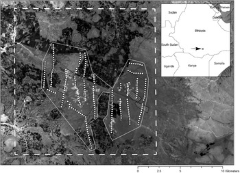
Satellite image of the Liben Plain, southern Ethiopia (January 2014, 30-m NDVI from Landsat). The large dashed rectangle indicates the 286-km2 area within which long-term crop expansion was measured from satellite imagery. White dots show the 252 transect waypoints. White asterisks indicate the locations of all Liben Larks recorded over the nine transect surveys. The white polygon indicates the 87.1-km2 area across which density estimates from distance sampling were extrapolated to generate population estimates (see text). The four smaller hatched polygons indicate the kalos mentioned in the text. In the satellite base map, cultivation appears darker than grassland.

The Liben Plain is one of only two known sites for Liben Lark Heteromirafra archeri, also known as Archer’s or Sidamo Lark (Collar Reference Collar2009, Spottiswoode et al. Reference Spottiswoode, Wondafrash, Gabremichael, Abebe, Mwangi, Collar and Dolman2009, Reference Spottiswoode, Olsson, Mills, Cohen, Francis, Toye, Hoddinott, Dagne, Wood, Donald, Collar and Alström2013, Donald et al. Reference Donald, Buchanan, Collar, Abebe, Gabremichael, Mwangi, Ndang’ang’a, Spottiswoode and Wondafrash2010). A limited survey in October 2019 of the second site, near Jijiga in north-eastern Ethiopia, suggested that very few birds remain there (Negussie Toye and Abiy Dagne pers. comm.), and the Liben Plain may therefore support the more viable of the two populations. The species formerly occurred in Somaliland, but is probably extinct there (Mills et al. Reference Mills, Cohen, Francis and Spottiswoode2015), and distribution models have failed to identify suitable areas elsewhere (Spottiswoode et al. Reference Spottiswoode, Olsson, Mills, Cohen, Francis, Toye, Hoddinott, Dagne, Wood, Donald, Collar and Alström2013). It is listed as ‘Critically Endangered’ on the IUCN Red List due to its small and declining population (BirdLife International 2020). A 40% decline in the number of Liben Larks recorded along the same transect routes between 2007 and 2009 coincided with changes in vegetation structure and loss of grassland to cereal crop production (Donald et al. Reference Donald, Buchanan, Collar, Abebe, Gabremichael, Mwangi, Ndang’ang’a, Spottiswoode and Wondafrash2010).
Between 2015 and 2018, a project funded by the UK government’s Darwin Initiative supported local people to establish four kalos (grassland reserves) covering 259 ha (Figure 1) and opened 950 ha of grassland by clearing encroaching scrubland (https://www.darwininitiative.org.uk/documents/22015/24529/22-015%20FR%20edited.pdf ). The purpose of kalos is to create fenced areas of tall, dense heterogeneous grass as both dry-season cattle forage and roofing materials for 1,300 households and to provide suitable breeding habitat for the Liben Lark. Although a series of censuses was undertaken between 2009 and 2019, these data have not hitherto been analysed to assess long-term changes in habitat area, habitat selection, grassland condition or population size. Furthermore, the effects on grassland structure of reducing or removing grazing pressure through the creation of fenced grassland reserves (kalos) have not yet been assessed.
We therefore (1) quantify long-term (1994–2019) changes in the area of grassland and crop farming using satellite imagery, (2) assess trends in a number of measures of grassland condition between 2007 and 2019, (3) estimate changes in the population size of Liben Lark between 2007 and 2019, (4) assess habitat selection by Liben Larks with respect to available habitats (recognising that none may now be optimal), and (5) compare measurements of grassland structure inside and outside four kalos created as part of an effort to seek conservation solutions for the Liben Lark that also benefit local people.
Methods
Study site
The Liben Plain is a relatively flat area of grassland at 1,500–1,550 m elevation, starting 10 km south-east of the town of Negele (Figure 1). It has a mean annual temperature of 20°C and a mean annual rainfall of 700 mm confined to two rainy seasons, a longer (main) one in March–June (traditionally known as ganna) and a shorter one in September–November (hagaya) (Ethiopian Wildlife and Natural History Society 1996). The main soil types comprise relatively infertile iron-rich red sandy loams (‘red soils’) and more fertile black clay and volcanic light-coloured silty clay, silt and vertisols (‘black soils’) (Coppock Reference Coppock1994).
Transect surveys
All field data were collected along 20 transects established during the first fieldwork on the Liben Plain in 2007 (Spottiswoode et al. Reference Spottiswoode, Wondafrash, Gabremichael, Abebe, Mwangi, Collar and Dolman2009); details of how count and habitat data were collected and analysed are given below. These transects were broken up into 250-m lengths by a series of 252 waypoints (Figure 1), at which vegetation data were collected. In 2007 all 252 waypoints were located in grassland, but over the years an increasing number were converted to agriculture (see Results), after which visits were not made to the lost waypoints and no measures of vegetation were taken to avoid damaging the crop. Despite this, we spent much time observing cereal crops as we walked around them to regain the transects, and were convinced that Liben Larks were not present in cropland. Several singing (therefore male) Liben Larks were seen over a newly sprouting patch of cereal near a grassland edge in 2011 (Collar and Donald Reference Collar and Donald2018), but this was the only time the species was observed using any habitat other than open grassland, and it may be the birds were singing over territories that had been established on grassland before it was ploughed and sown.
Field data were collected by the authors and others in various combinations in June 2007 (survey 1), May 2009 (survey 2), June 2010 (survey 3), May 2011 (survey 4), November 2012 (survey 5), May 2013 (survey 6), October–November 2013 (survey 7), June 2018 (survey 8) and May–June 2019 (survey 9). Surveys were timed to coincide with one of the two annual rainy seasons, as this was likely to coincide with peak Liben Lark breeding activity and song (Collar and Donald Reference Collar and Donald2018) and hence greatest detectability.
Measuring loss of grassland area
To assess long-term land use change on the Liben Plain and its environs using satellite imagery, we selected a rectangular area of 286 km2, centred on the remnant Liben Lark population but also extending out into areas where grassland was present in 2007 but larks were not recorded (Figure 1). Black soil within this area covers an area of 103 km2 (36.0%), estimated from Landsat imagery (from which the different soil types can readily be distinguished by eye; Figure S1 in the online supplementary material); the rest of the area is covered by red soil. We downloaded 43 freely available Landsat 1-8 satellite images of the study area from the Global Visualization Viewer (GLOVIS) website from the years 1972–1995 and 2000–2019 (obstruction-free images from 1996–1999 were unavailable) at 30-m resolution. The images were stacked and clipped to the area of interest in ArcGIS Desktop (version 10.2). No pre-processing of the images was required as the maps were used simply to guide manual digitisation. The arable lands on red and black soils were digitised separately for each year and the cultivated area each year was then calculated in ArcMap using a Mollweide equal area projection.
Vegetation surveys and vegetation change
During each field survey, grassland structure variables were recorded at each waypoint and at each location at which Liben Larks were first detected during transect surveys using the methods described in Spottiswoode et al. (Reference Spottiswoode, Wondafrash, Gabremichael, Abebe, Mwangi, Collar and Dolman2009) and Donald et al. (Reference Donald, Buchanan, Collar, Abebe, Gabremichael, Mwangi, Ndang’ang’a, Spottiswoode and Wondafrash2010). The methods were designed to be highly repeatable across observers and years. Within a 25-m radius of the waypoint or bird location we recorded the number of trees, Giant Fennel Ferula communis plants (the only common herbaceous plant that stood much taller than the grass), paths (as an index of human disturbance) and harvester ant Messor cephalotes nests (which are large, circular bare patches in the grassland and form the only naturally occurring areas of bare ground on the plain). Within two 5-m radius circles centred 10 m either side of the waypoint we counted the number of bushes and cowpats (as an index of grazing pressure), and estimated by eye the percentage of bare ground and the percentage cover of four grass height categories (<5 cm, 5–15 cm, 15–40 cm and >40 cm) (Spottiswoode et al. Reference Spottiswoode, Wondafrash, Gabremichael, Abebe, Mwangi, Collar and Dolman2009). The four estimates of grass cover by height class were combined into a single grass height index for analysis by multiplying the percentage cover of each height class by the mid-points 2.5, 10, 28 and 40, respectively, and summing them (range of possible values: 0–4,000). At the start of each survey, all observers undertook a number of habitat assessments together to ensure comparable recording.
For analysis of changes in grassland condition we only included data from the 168 (66.7%) transect waypoints which remained as grassland throughout the entire period of coverage and for which data were therefore available in each of the nine field seasons. The remaining 84 transect points were converted to cropland during the period of coverage and so lacked measurements of grass condition for some or most years (nine returned to grassland after the abandonment of cultivation). Owing to the uneven distribution and relatively small number of visits across the survey period, we did not attempt to fit time series models to examine temporal patterns of change, but instead treated visit as a fixed factor and assessed significant differences between visits. Counts of fennel plants, trees, bushes, ant nests and paths were heavily skewed by a large number of zeros and non-zero counts were generally low (typically 1 or 2 for most variables), so we analysed changes over time in the presence or absence of these variables using generalised linear mixed models in which the presence or absence of each variable was modelled as an effect of survey, with transect waypoint nested within transect fitted as a random effect to control non-independence of repeat measures from the same points (Bolker et al. Reference Bolker, Brooks, Clark, Geange, Poulsen, Stevens and White2009). The count of cowpats present was modelled using Poisson errors with a log link, whereas the percentage of bare ground and the log of grass height index were approximately normally distributed and modelled using general linear mixed models and an identity link; again, waypoint and transect were fitted as nested random effects. Pairwise differences between visits were assessed from the models with post hoc Tukey HSD tests using the glht function in the R package multcomp (Hothorn et al. Reference Hothorn, Bretz and Westfall2008). All models were checked for overdispersion using a function that compares residual degrees of freedom with residual variance. Analyses were undertaken using R v. 4.0.1 (R Core Team 2020).
Liben Lark population estimates
We surveyed Liben Larks using the transect methods described by Spottiswoode et al. (Reference Spottiswoode, Wondafrash, Gabremichael, Abebe, Mwangi, Collar and Dolman2009) and Donald et al. (Reference Donald, Buchanan, Collar, Abebe, Gabremichael, Mwangi, Ndang’ang’a, Spottiswoode and Wondafrash2010). Similar methods have subsequently been shown to be efficient for surveying other rare larks in large, open areas (Pérez-Granados and López-Iborra Reference Pérez-Granados and López-Iborra2016). Transect surveys were undertaken from 06h30 to 11h00 only in suitable weather conditions. Along each transect observers recorded the number and activity of all Liben Larks seen or heard, and GPS coordinates were taken where each individual was first sighted. Singing birds were assumed to be males, as singing in females is very rare in larks (Donald and Alström Reference Donald and Alström2021 in press). For each observation, the perpendicular distance to the bird from the transect line was estimated in GIS for distance sampling (Buckland et al. Reference Buckland, Anderson, Burnham, Laake, Borchers and Thomas2001). In June 2018 we had sufficient time and capacity to walk the transects twice, but on neither occasion did we record sufficient birds for distance sampling (see below).
Transect count data were analysed using the Conventional Distance Sampling (CDS) engine of Distance v. 6.2 software (Thomas et al. Reference Thomas, Buckland, Rexstad, Laake, Strindberg, Hedley, Bishop, Marques and Burnham2010). Density was expressed as number of individuals per km2. The shape criteria of distance histograms were examined for heaping or cluster bias and where necessary any outliers were right-hand truncated (Thomas et al. Reference Thomas, Buckland, Rexstad, Laake, Strindberg, Hedley, Bishop, Marques and Burnham2010). The actual values for truncation and subsequent grouping of records into distance bands were determined through visual inspection of histograms (Thomas et al. Reference Thomas, Buckland, Rexstad, Laake, Strindberg, Hedley, Bishop, Marques and Burnham2010). Data were truncated to 300 m to improve modelling of the detection function, thus minimising any bias caused by the few data points recorded beyond this distance. Three key functions (uniform, half-normal and hazard rate, all with cosine series adjustment) were considered for each analysis (Buckland et al. Reference Buckland, Anderson, Burnham, Laake, Borchers and Thomas2001). Key function selection was evaluated using Akaike’s Information Criterion (AIC), and a χ2 statistic was used to assess the goodness of fit of each function (Buckland et al. Reference Buckland, Anderson, Burnham, Laake, Borchers and Thomas2001). We estimated the population density of Liben Larks first by using a global detection function based on all data pooled from all surveys, and then estimated densities per survey year by post-stratifying the same global detection function by survey. This assumes—reasonably (but necessarily, due to small sample sizes)—that detectability did not differ significantly across years. The reliability of density estimates was provided using the percentage coefficient of variation (% CV) and 95% confidence intervals (95% CI).
Population estimates for each visit were derived by multiplying the estimated densities from distance sampling by the area of a minimum convex polygon encompassing all transect surveys points, from which two areas in the centre of the plain that were already under crops at the time of the first survey were excised, and which was then buffered by 300 m to account for the transect truncation distance (total area = 87.1 km2; Figure 1). This was then multiplied by the proportion of the 252 transect waypoints that had not been converted from grassland to cropland in the respective year, to account for changing grassland area. Extensive searches outside this polygon, particularly in apparently suitable grassland at the eastern end of the plain (Figure 1), failed to record any birds there and we are confident that the clipped minimum convex polygon contained most or all individuals in this population since 2007. In 2018 and 2019, too few birds were recorded during the transect counts to calculate density estimates effectively.
Habitat selection
We assessed habitat selection of Liben Larks by comparing field measurements taken at locations where birds were first encountered during transects with those taken at transect waypoints, which were assumed to constitute a representative random sample of conditions across the plain. The presence or absence of larks was fitted as a binary variable in a generalised linear mixed model with binomial errors and a logit link function. Transect nested within survey was fitted as random effects to control the non-independence of observations along transects and within years (lark locations were assigned to the transect from which they were observed). The presence/absence variable was modelled as a function of the log of the grass height index, the percentage of bare ground and the number of bushes, ant nests, paths and fennel plants. All explanatory variables were scaled to zero mean and unit variance. We used variance inflation factors to assess the degree of collinearity in the predictors and, as these were always less than 1.5, we then estimated the model-averaged coefficients for each predictor across all possible subsets of the full model, including the full model itself, to identify predictors with model-averaged coefficients whose upper and lower 95% CI did not span zero.
Results
Changes in grass and crop cover across the Liben Plain
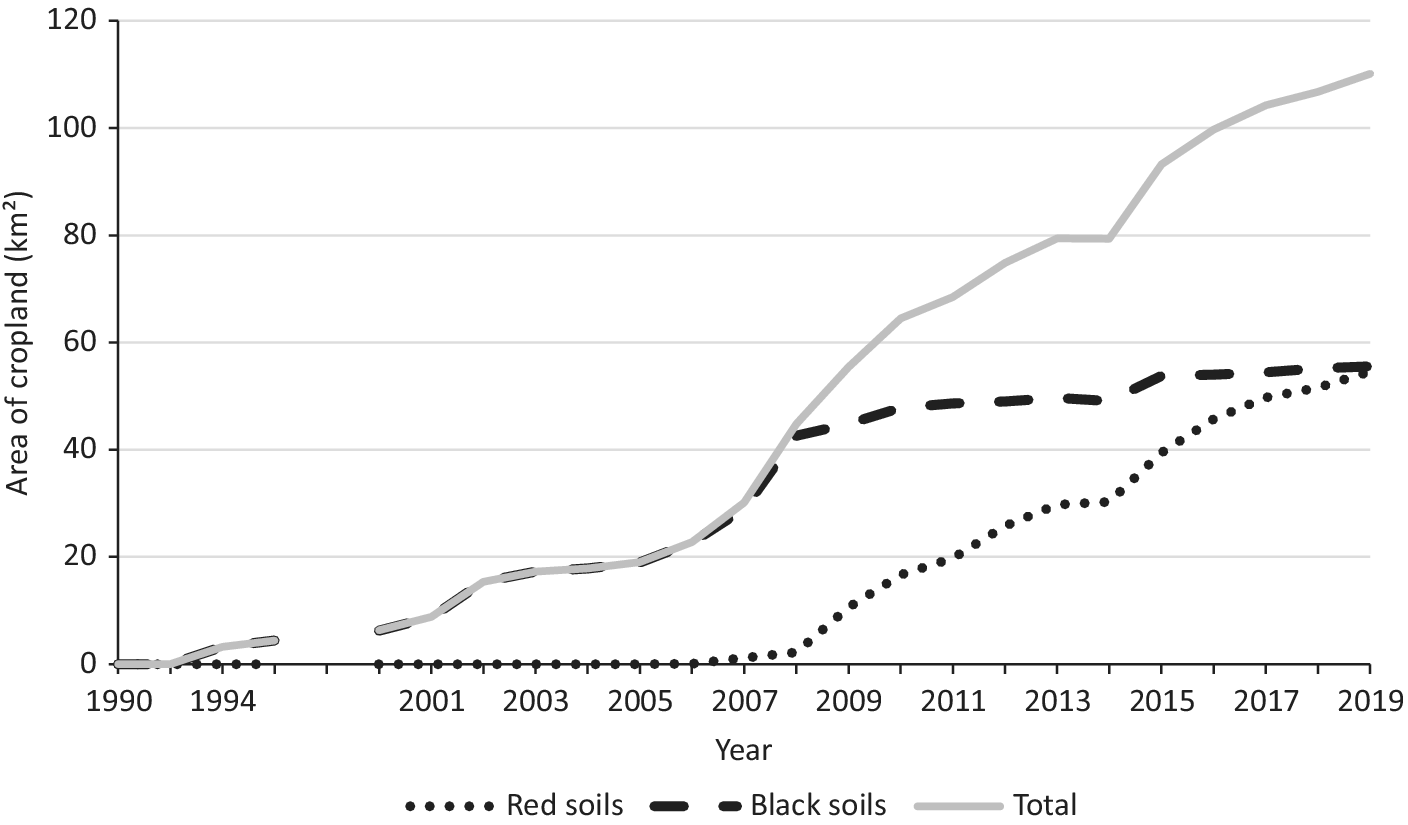
Within the 286-km2 rectangle containing the Liben Plain and its immediate environs (Figure 1) arable cropland first appeared in 1994, after which it expanded rapidly to cover a total area of 110.2 km2, or 38.5% of the area, by 2019 (Figure 2, Figure S2). By 2006 most of the more fertile black soils were under permanent cultivation, after which there was a sharp increase in cropland on the less fertile red soils, such that by 2019 the areas of red and black soils under cropland were almost equal. There was no evidence that the rate of conversion of grassland to crops has slowed over time, although field observations from 2019 indicated that some abandoned cropland was reverting to grassland. A similar rate of conversion of grassland was apparent along transects, where 75 (29.8%) of the 252 transect waypoints established in grassland in 2007 had been converted to cropland by 2019 (by which year nine transect points previously converted to crops had reverted to grassland).
Changes in the area of cropland within a 286-km2 rectangle (see Figure 1) enclosing the Liben Plain, 1990–2019, taken from visual digitisation in GIS of Landsat imagery. No obstruction-free images were available for 1996–1999. Analysis of images back to 1972 (data not shown here) confirmed that crops first appeared in the area in 1994. The areas of cropland on red and black soils are shown separately and summed.

Trends in grassland condition
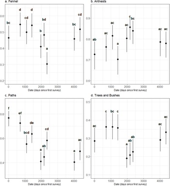
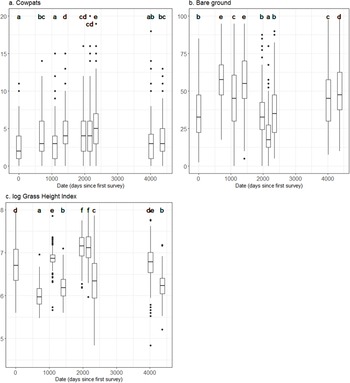
Field measurements of grassland structure and condition were uncorrelated except for a strong negative correlation between grass height index and percentage of bare ground. There were significant pairwise differences between surveys in the proportion of points at which ant nests, fennel, paths, trees, and bushes were recorded, but no clear trend over time in any of them (Figure 3). Similarly, there were significant pairwise differences between surveys in number of cowpats recorded per point, percentage of bare ground, and grass height index, but again with no clear trend over time in any of them (Figure 4).
Changes over time (nine surveys from the first in 2007 to the most recent in 2019) in the modelled probability of the presence or absence (±95% CL) at fixed transect waypoints across the Liben Plain of (a) fennel Ferula plants, (b) nests of harvester ants, (c) paths or tracks, (d) trees and bushes. Surveys sharing one or more letters did not differ from each other at P < 0.05 in the respective attribute.

Changes over time (nine surveys from the first in 2007 to the most recent in 2019) in (a) number of cowpats, (b) percentage of bare ground and (c) grass height index (logged) recorded at fixed transect waypoints. Data are shown as boxplots. The associated tests of significant pairwise differences are derived from generalised linear mixed models (see text). Surveys sharing one or more letters did not differ from each other at P < 0.05 in the respective attribute.

Habitat selection
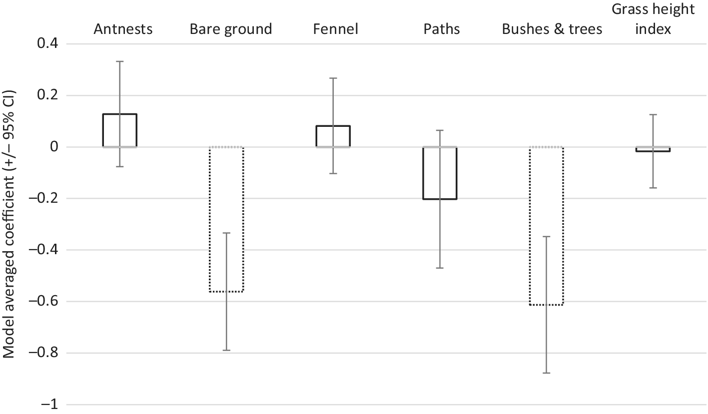
Model-averaged parameters from models of the presence or absence of larks indicated their strong avoidance of bushes and trees and of areas with high cover of bare ground (Figure 5). There was also some evidence for a selection for areas around ant nests and a weak avoidance of paths and tracks. Interpretation of these models is discussed further below.
Model-averaged parameters (±95% CI), estimated over all subsets of the full model, of the presence or absence of Liben Larks (see text for full details). Negative parameter estimates indicate negative association of the variable with the presence of Liben Larks. Model-averaged parameters shown with dotted lines differed significantly from zero at P < 0.0001; all others were not significantly different from zero (P >0.05).

Liben Lark population estimates
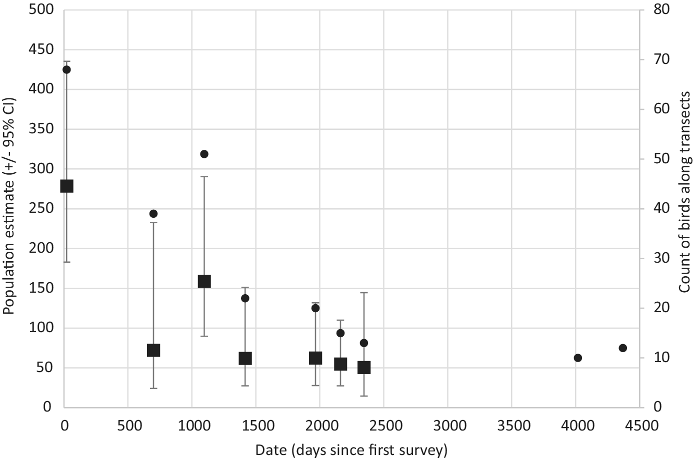
The overwhelming majority of birds recorded along transects were singing males, so population estimates are more reflective of the number of territorial males than the number of individuals overall. The number of birds counted along the fixed transect routes varied between 10 (in 2018) and 68 (2007) (Figure 6). Densities of Liben Larks within the buffered MCP described by the transect points, estimated from distance sampling, varied between 3.2 singing birds/km2 (95% CL: 2.1–5.0) in 2007 to 0.7 singing birds/km2 (95% CL: 0.2–2.0) in 2013. These translated into overall population estimates of 279 singing birds (95% CL: 182˗436) in 2007 to 51 (14˗144) in 2013, accounting for changes in both density and grassland area (Figure 6).
Population estimates (squares, ±95% CL, left axis) of territorial Liben Larks, 2007–2013, and counts of larks (dots, right axis) recorded along transects, 2007–2019.

Grassland structure in kalos
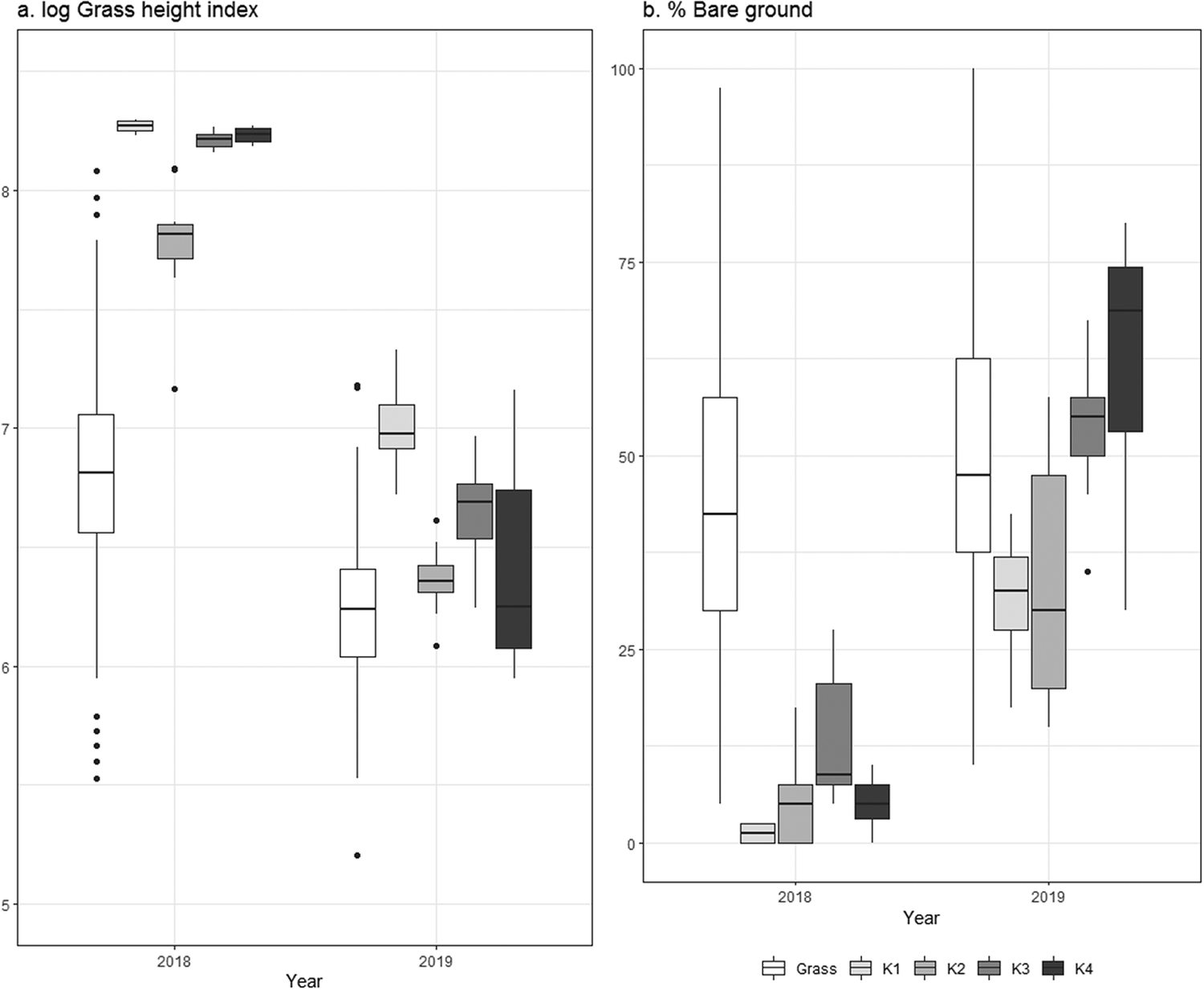
In 2018, the grassland height index was significantly higher in all four kalos and the percentage of bare ground significantly lower than in grassland outside the kalos (Figure 7). In 2019, however, long after the fences had been broken and cattle allowed entry to the kalos, the grassland structure in the kalos was much more similar to that of the grassland across the Liben Plain: the grass height index was still higher and the area of bare ground lower than grassland across the plain in two kalos, but not significantly different in the other two (Figure 7).
Boxplots of log-transformed grass height index (a) and percentage of bare ground (b) measured at grassland transects across the Liben Plain (open bars) and along transects within each of four kalos (K1–K4, shaded bars; Fig. 1) in 2018 and 2019.

Discussion
Our results suggest that the population of Liben Larks on the Liben Plain, as estimated from raw counts of birds along transects, declined by over 80% between 2007 and 2019 and may now comprise fewer than 50 territorial males, although the precision of our population estimates is very low. As there is evidence that the adult sex ratio is heavily skewed towards males (Collar and Donald Reference Collar and Donald2018), as is usually the case in declining and threatened bird populations (Donald Reference Donald2007), the effective population may be considerably lower than 50 pairs. A rapid survey in 2019 of the only other known population, near Jijiga in north-eastern Ethiopia, found only small numbers in remaining patches of grassland, suggesting it is similarly threatened there and indicating the urgent need for a comprehensive survey. On this evidence the Liben Lark is poised to become mainland Africa’s first recorded bird extinction. The only congeneric species, Rudd’s Lark H. ruddi of South Africa, is also highly threatened and declining (Gush et al. Reference Gush, Maphisa, Reynolds, Donald and Spottiswoode2019), so that the survival of an entire genus of birds is at risk.
Our results show that the Liben Plain has been affected by the same changes that have afflicted grasslands across Ethiopia in the past 50 years: despite frequent harvest failures (Tolera and Abebe Reference Tolera and Abebe2007), the impetus for arable cultivation is such that even infertile red soils are being converted to cereal production, with communal land often being appropriated illegally by agricultural investors from elsewhere (Boru et al. Reference Boru, Schwartz, Kam and Degen2015). The decline in the Liben Lark’s population on the Liben Plain since the first survey in 2007 is correlated with an increase in cereal coverage that satellite imagery shows started in 1994, around the time that Borana pastoralists and Arsi agropastoralists first became permanently settled on the plain.
However, the approximately 80% decline in the lark’s population between 2007 and 2019 greatly exceeds the less than 40% loss of grassland over the same period, suggesting that conversion to cropland is not the only (and perhaps not even the main) driver of the decline. We detected no long-term trends in a number of other metrics of grassland use or condition over the same period, including the prevalence of bushes or bare ground, which were negatively associated with the presence of Liben Larks. We consider that changes in grassland management and structure that occurred before our first survey in 2007, and have not subsequently been reversed, may have reduced the species’ productivity or survival such that the population has entered long-term decline. Examples from elsewhere in Africa have shown that poorly managed rangelands can transition from productive to less productive, yet nevertheless stable, states (e.g. Briske et al. Reference Briske, Fuhlendorf and Smeins2005) and our data suggest that this is what has happened on the Liben Plain. Although too few nests have been found to estimate breeding success, it appears to be very low, probably because the short swards of the heavily overgrazed grassland offer few safe nest sites (Collar and Donald Reference Collar and Donald2018). That Liben Lark is a species adapted to heavily grassed habitats is evidenced by its long hallux (hind-claw) (Green et al. Reference Green, Barnes and Brooke2009), and by its construction of a nest covered by a grass dome (Collar and Donald Reference Collar and Donald2018). In contrast, Somali Short-toed Lark Alaudala somalica, which is abundant on the Liben Plain, has (as its common name implies) the short hallux of a species adapted to bare ground, on which it builds an open nest.
If the extinction of the Liben Lark is to be averted, means must be sought to improve the condition and extent of grassland on the Liben Plain, to the mutual benefit of both birds and local people. Crop field abandonment following harvest failures could present an opportunity to restore smaller patches of the Liben Plain to suitable areas for dry-season grazing and, perhaps, suitable vegetation for the Liben Lark, but this alone is unlikely to be sufficient to avert the lark’s extinction.
The tall, dense grass cover that developed rapidly in the kalos certainly indicated that the Liben Plain retains the potential to recover quickly if grazing pressure can be controlled. However, it appeared to be too tall and dense to allow occupation and breeding by Liben Larks, which we never saw in fully tended kalos, although a kalo half-grazed by intruding cattle was found to host a breeding pair of Liben Larks (seen carrying food to hidden young). This suggested that a controlled grazing regime may be required within kalos to develop an optimal vegetation structure for the species, as might be expected to have existed when wild ungulates roamed the Liben Plain. Socioeconomic pressures led to the partial removal of kalo fencing early in 2019, and the entry of cattle caused the previously dense grassland within the kalos to revert to the heavily grazed structure of the rest of the plain. Nevertheless, a survey of 200 households found that 87% reported benefiting from the brief presence of the kalos (SRW and colleagues, unpubl. data). Thus, while initial results were discouraging, there is reason to think that more extensive kalos within which grazing pressure is managed at levels that promote a suitably heterogeneous sward for breeding and foraging Liben Larks, represent the best option for the conservation of the species in the short term. These are likely to be more effective if embedded within a participatory land-use plan for the plain that considers the views and needs of all relevant stakeholders. However, the long-term survival of the species, and of the traditional Borana way of life, is likely to depend on the restoration and expansion of rangeland across the entire plain through the reversion of cropland to grassland, a reduction in grazing pressure (including the reintroduction of lengthy resting periods), the clearance of encroaching scrub around the edges of the plain and a revival of the gada system. Examples of such restoration at large scales are unfortunately very rare, and the future of the Liben Lark remains very uncertain despite ongoing conservation efforts.
Supplementary Material
To view supplementary material for this article, please visit http://doi.org/10.1017/S0959270920000696.
Acknowledgements
Our work on the Liben Plain was funded over the years by various sources acknowledged in earlier papers, but notably by the UK Darwin Initiative, the A. G. Leventis Foundation and Julian Francis. Field data were collected by ourselves and the late M. Bekele, K. Blomerley, A. Dagne, M. Davies, L. D. C. Fishpool, M. N. Gabremichael, M. Kariuki, S. Jervis, D. Lindo, A. Morris, K. Mwangi, A. D. Ruffo, W. Sara, G. Sherkete, M. Smith, R. Spencer, C. N. Spottiswoode, and S. Zekele. We have been greatly assisted for years by Abiy Dagne, and we dedicate this paper to the late Negussie Toye, a great supporter of Liben Lark conservation. We thank the Associate Editor and two anonymous reviewers for helpful comments.