Introduction
In 2004, excavations conducted by the authors at site SbJk-1 located approximately 10 km east of Cape Southwest on southern Axel Heiberg Island, Nunavut, confirmed the site's association with the ill fated 1930 German Arctic expedition led by Hans K.E. Krüger (Barr Reference Barr1993, Reference Barr2004; Brooks and others Reference Brooks, England, Dyke and Savelle2004; Park and Stenton Reference Park and Stenton2007). Krüger and the two other members of his expedition team (a Dane, Åge Rose Bjare and the Inughuit hunter Akqioq) had set out in March 1930 to conduct geological research in the Axel Heiberg Island region and did not return. Extensive search efforts in 1932 by the Royal Canadian Mounted Police (RCMP) produced a single document left by Krüger at Cape Thomas Hubbard at the northern tip of Axel Heiberg Island. In the mid-1950s, two other Krüger messages were found in cairns on northwestern Ellesmere Island (Hattersley-Smith 1954) and on Meighen Island (Thorsteinsson Reference Thorsteinsson1961).
The last of the three cairn messages, discovered in 1957, was left at Andersen Point on the west coast of Meighen Island and it identified Krüger's next destination as Cape Sverre at the northern tip of Amund Ringnes Island (Thorsteinsson Reference Thorsteinsson1961: 9). Because no trace of the party was found at Cape Sverre or elsewhere on Axel Heiberg Island, researchers speculated that the three men had succumbed to carbon monoxide poisoning, or had possibly fallen through thin ice and drowned (Thorsteinsson Reference Thorsteinsson1961; Barr Reference Barr1993). However, the discovery in 1999 of the SbJk-1 site near Cape Southwest established that some or all of Krüger's team had in fact made their way from Meighen Island back to Axel Heiberg Island, although the question of a possible landfall at Amund Ringnes Island remained uncertain.
The artefact assemblage that was recovered from SbJk-1 contained a variety of materials including a compass, transit, fragments of canvas and rope, buttons, articles of clothing, and pieces of wooden boxes (Park and Stenton Reference Park and Stenton2007). The assemblage also included 83 geological samples, 57 of which were collected from the surface of the site. Undoubtedly, these had originally been placed in a wooden box or possibly in one or more canvas bags that had disintegrated when the cache was destroyed soon after it was constructed, perhaps by bears. Fragments of paper wrapping were found with several of these specimens. However, a large metal can containing 26 additional specimens was also recovered. The can had rusted through in places but its contents were much better preserved. Most of the specimens from the can were still completely wrapped in paper, although in several cases it was in poor condition or had not survived. Found within the outer paper wrapping of all but six of the geological samples was a separate small paper specimen label on which Krüger had written information about each sample. In this article we use the information from those labels to reconstruct the route and rate of travel of the German Arctic expedition in much greater detail than was previously known.
The specimen labels
The labels originally measured approximately 11 cm by 4.75 cm, and each was folded in half after the information had been recorded. The text is written in pencil and consists of three fields: (i) a catalogue or sample number in the upper left, (ii) the collection date in the lower left, and (iii) the collection location, usually written in the central part of the label, occasionally in two lines. The location information often includes a specific location plus the name of a region or island. The label text is mostly in German, with English occasionally used for pre-existing place names (for example ‘Cape Mokka’). The month is always written in Roman numerals and in a few cases ‘No.’ preceded the specimen's catalogue number.
In retrospect, it is remarkable that any of the specimen labels survived in readable condition. All but five of the labels were damaged, and when opened at the Canadian Conservation Institute, they were covered with sand, dirt, rust stains and concretions from the tin can and, in some cases, black mould. Areas of many of the labels had also been lost through abrasion against the irregular edges of the rock specimens.
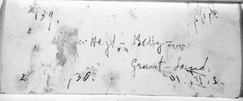
Several additional factors made opening and reading the labels difficult. Because the paper was degraded and compressed, in a dry state it was extremely brittle and easily damaged when handled. When wet, the paper had no strength and easily tore or stretched. Continuous wetting and drying of the paper over 74 years in the Arctic had also caused the paper fibres to act like papier mâché and reform into new layers. As a result, when opened the original writing surface was not always fully exposed and text was sometimes obscured by thin layers of paper that had detached from the opposite side of the label, or had transferred to the opposite side of the label as a mirror image. Fig. 1 is an infrared photograph of a specimen label from Ellesmere Island showing the reversing of text that occurred on many of the labels. In a number of cases, analysis of the reverse imaging played an important role in determining the content of one or more of the text fields.
Infrared image of specimen label 189 showing lifting and transferring of text.

Each label took between one and three days to open; those in good condition were opened dry, while those in poor condition proved easier to open while wet. To give added support during opening, labels in poor or fragmentary condition were backed with Japanese tissue using an acrylic adhesive (Lascaux 360 HV). The labels were wetted again and carefully opened under magnification using a scalpel, and then dried between Remay and felt blotters under weights. Labels heavily stained or held together by deposits of rust were cleaned in a reducing/chelating solution of 0.2M sodium dithionite/0.2M diethylene triamine pentaacetic acid buffered to a pH of 7.0 followed by rinsing. Detached fragments and tears were repaired with fine conservation-quality Japanese tissue and wheat starch paste. After opening, the labels were photographed using infrared light (IR), which enhanced the writing and reduced some of the staining.
23 specimen labels were recovered with the 26 rock samples. Because of the deterioration of some of the outer wrappings, the association of three labels with their specific geological specimens has been lost. However, this does not affect the utility of their date and location data. Based on our analysis, the specimen catalogue numbers range from approximately 150 to 228. The lowest number in the sequence is uncertain, but the first two digits are 15, making the catalogue number somewhere between 150 and 159. The label bearing the highest number in the sequence is damaged and difficult to read, but we interpret it to be number 228. Estimating the total number of specimens Krüger cached at SbJk-1 using the catalogue numbers is difficult, but we believe that a figure between 80 and 90 represents a reasonable approximation. Large gaps exist in parts of the sequence of the labels that survived (for example between numbers 150 and 180, only 20% of the possible maximum of 30 labels survived), but because Krüger collected multiple specimens from individual locations (in one case at least 10 specimens in one day) we believe the SbJk-1 catalogue label assemblage reflects the majority of the locations from which collections were made.
Expedition itinerary
Krüger arrived at the RCMP detachment at Bache Peninsula on 12 March 1930 and, accompanied by two support sledges, he departed westwards the following week through Bay Fiord en route to Depot Point on the east coast of Axel Heiberg Island (Barr Reference Barr1993). We estimate that the group reached Depot Point near the end of March, soon after which the support party commenced their return trip to Bache Peninsula, which they reached on 11 April, having completed the round trip in 24 days.
During the initial leg of his journey, Krüger was actively collecting geological samples, as the support party returned with five boxes of specimens collected between Bache Peninsula and Depot Point (Barr Reference Barr1993: 289). As noted, Krüger also sent equipment back to Bache Peninsula from Depot Point for reasons that, presumably, included lightening the load. Because the geological samples were unnecessary weight, it seems logical that he would have sent back the entire collection made up to that point. These samples were returned to Germany and included in the 1933 Nordlandschau Exhibition at the Treptow Observatory in Berlin. According to information obtained from the archivist at the Archenhold (formerly Treptow) Observatory, the Krüger collection was subsequently housed at the Technische Hochschule in Darmstadt, which was completely destroyed during World War II (R. Proschitzki, personal communication, July 2009).
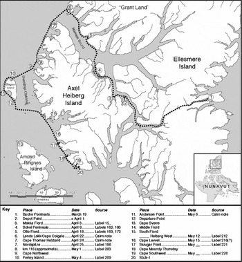
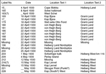
Krüger had plotted one version of his intended route on a map (Barr Reference Barr1993: Fig. 9), but he apparently conveyed somewhat different plans to different people (Barr Reference Barr1993: 287–288), and prior to the discovery of SbJk-1 few details were known about the actual course that he had followed. The information contained in the specimen labels allows reconstruction of much of the route taken by the German Arctic expedition over a period of approximately six weeks (43 days), from 3 April to 15 May 1930 (Fig. 2, Table 1). At the time of the search expeditions, based on information conveyed to authorities by the support party that accompanied him on the apparently difficult first leg of the journey from Bache Peninsula to Depot Point, Krüger's course was presumed to have differed from that shown on the map that he had sent back to Germany. The two Inughuit of the support party reported that Krüger's intentions were to travel around the northern tip and then down the west coast of Axel Heiberg Island (Thorsteinsson Reference Thorsteinsson1961: 9; Barr Reference Barr1993:288–289). They also brought back to Bache Peninsula some of Krüger's scientific equipment, including an echo sounder, confirming that Krüger recognised early in the expedition the need to reduce the amount of gear being transported, which in turn may have contributed to a decision to alter his original research agenda and, thus, his route. The change in course reported by the support party suggests that Krüger had cancelled the plan to conduct soundings of the continental shelf from the sea ice several hundred kilometres northwest of Axel Heiberg Island and, on the return route, also to stop at northwestern Ellef Ringnes Island.
Map of Axel Heiberg Island region showing route of 1930 German Arctic expedition as reconstructed from geological specimen labels and the three known cairn notes.

List of geological sample labels from SbJk-1, Axel Heiberg Island.

Depot Point to Cape Colgate
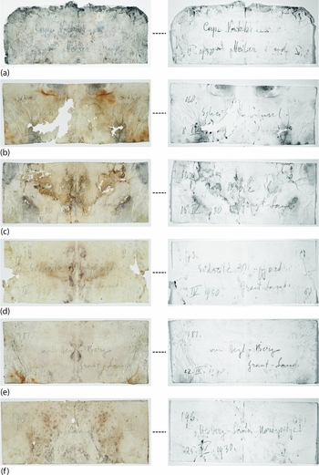
The first group of specimen labels consists of 12 that relate to the period following Krüger's departure from Depot Point to his depositing a message in a cairn near Cape Colgate on Ellesmere Island on 22 April. Assuming the group arrived at Depot Point sometime near the end of March, Krüger, Bjare and Akqioq appear to have spent little time there before continuing their journey. On 3 April, they collected a geological sample from ‘Cape Mokka’ (Fig. 3a), but no landform by that name exists and we infer that it is located somewhere on the headland forming the south side of the entrance to Mokka Fiord, approximately 20 km west of Depot Point. Five days later, on 8 April, they collected a sample from Schei Peninsula (Fig. 3b), the base of which is situated 65 km north of Mokka Fiord. A second sample, for which the date is missing, is labeled ‘West-Schei’, which we presume was collected soon afterwards somewhere along the west coast of Schei Peninsula.
Post-treatment natural light (l) and infrared images (r) of labels 15_, 160, 169, 173, 181 and 196. For the full text of each label see Table 1.

According to the course indicated on the map that Krüger sent to Germany, from Schei Peninsula he intended to travel north through Flat Sound into Nansen Sound and then northwest along the coast of Axel Heiberg Island to its northern tip. The catalogue labels, however, demonstrate that he crossed Nansen Sound to Ellesmere Island because the remaining nine labels in this series all identify the region as ‘Grant-Land’, which is the northern lobe of Ellesmere Island.
The labels from the Ellesmere Island part of this series cluster around two dates: 18 and 22 April. Although difficult to read due to their poor condition, of the three labels dated 18 April, two appear to be from ‘Kap Bjare’ (‘Cape Bjare’) (Fig. 3c). No landform of this name is recorded on current topographic maps or in the Government of Nunavut's toponymy database, and so it seems clear that Krüger named the (unknown) location in honour of his Danish assistant Åge Rose Bjare. As this sample was collected on the same day as the next label in the sequence, ‘Cape Bjare’ would presumably be located within a short distance of this location. Due to the transfer and overlapping of characters, the text of the third label dated 18 April (Fig. 3d) is also difficult to read, but we interpret it as ‘süd seite O__ -fiord’, almost certainly ‘south side of Otto Fiord’. If our interpretation of these labels be correct, Krüger may have altered his intended course and crossed over to the coast of Ellesmere Island due to poor ice conditions in Nansen Sound. Barr (Reference Barr1993: 294) noted that in 1932 H. Stallworthy RCMP encountered rough ice in Nansen Sound to the northwest of Schei Peninsula, forcing him to ‘swing almost right over to the mouth of Otto Fiord’. If Krüger encountered similar ice conditions in 1930, this could explain why he crossed over to Ellesmere Island where he traveled for several days.
No labels were recovered for the next six entries (numbers 174 – 179) in the catalogue series. The seven remaining labels in this group begin with 180 and are all dated 22 April 1930. In each case the collection location is ‘von Hegh-Berg’ the meaning of which is unclear (Fig. 3e). The German preposition ‘von’ means ‘from’ but none of the labels from other locations use that word, so the words ‘von Hegh’ seem to go together. Thus, a literal translation would be ‘von Hegh mountain.’ Accordingly, and as in the case of ‘Kap Bjare’, we believe that ‘von Hegh-Berg’ refers to a place named by Krüger, the precise location of which is unknown. However, we can approximate its general location based on Kruger's cairn message recovered 6 km west of Cape Colgate (Hattersley-Smith Reference Hattersley-Smith1955: 35), which is also dated 22 April. The fact that all of the samples were collected the same day as Krüger deposited the cairn record suggests that ‘von Hegh-Berg’ is located in the general vicinity of Cape Colgate. Moreover, the number of specimens that Krüger collected from this location (at least 10) indicates that the geology of the site was of special interest to him
Cape Colgate to Axel Heiberg Island
In his cairn message left at Cape Colgate, Krüger identified the northern tip (‘nordspitze’) of Axel Heiberg Island, roughly 75 km to the southwest, as his next destination. The cairn document recovered at Cape Thomas Hubbard by Stallworthy in 1932 confirmed Krüger's arrival there on 24 April 1930 and his plan to proceed next to Meighen Island. These cairn documents also provide a means of estimating the party's rate of travel over a short period of time. If Krüger departed from Cape Colgate on 22 April and arrived at Cape Thomas Hubbard on 24 April the party was averaging approximately 30 km per day. This supports Krüger's statement in his cairn message that his companions and the dogs were in good condition, and implies that weather and ice conditions were also favourable.
No labels were recovered for catalogue numbers 190 to 195. The collection includes three labels, including label 196, dated 25 April 1930, two of which are captioned ‘Heiberg Land Nordspitze’ (Fig. 3f). A third label, for which the number cannot be determined, is also dated 25 April and we believe it was also collected from northern Axel Heiberg Island.
Axel Heiberg Island to Perley Island and Meighen Island
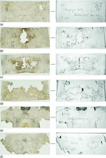
The text of both the Cape Thomas Hubbard and the Anderson Point cairn documents could leave the impression that the expedition members traveled directly from ‘nordspitze’ on Axel Heiberg Island to Meighen Island. However, consistent with the account of the support party, the catalogue labels establish that Krüger followed a course southward along the northwest coast of Axel Heiberg Island for more than 100 km before crossing the sea ice to Meighen Island. Label 203 (Fig. 4a) is dated 1 May and is noteworthy for several reasons. In addition to being one of the best preserved labels, unlike any of the others it identifies the general type of rock collected (‘schiefriger kalk’; slaty limestone). It records a general collection location, in this case ‘Heiberg West’, but is unique in that it is the only label in the assemblage that contains a reference to a distance: ‘km 116’. A point 116 km on a bearing southwest of Cape Thomas Hubbard along the west coast of Axel Heiberg Island terminates just north of Cape Northwest, suggesting that it may have been from this point, or possibly from Cape Northwest itself, that Krüger changed course for Meighen Island. Interestingly, Krüger collected very few geological specimens between 25 April and 1 May as there are only two missing catalogue numbers between the highest entry from the Cape Thomas Hubbard area (200) and label 203.
Post-treatment natural light (l) and infrared images (r) of labels 203, 209, 212, (Cape Levvel), 221 and 228. For the full text of each label see Table 1.

The 1 May date of label 203 also indicates a significant reduction in the expedition's rate of travel. That Krüger was not sustaining the rate of travel that he achieved between Cape Colgate and Cape Thomas Hubbard is demonstrated by the fact that it took seven days to cover the 116 km between Cape Thomas Hubbard and the vicinity of Cape Northwest (that is approximately 16.5 km per day) despite the fact that they clearly were not spending time collecting specimens.
Perley Island
By 4 May 1930, three days after collecting specimen 203, Krüger had reached Perley Island situated approximately 50 km west of Axel Heiberg Island and several kilometers north of Meighen Island. At least one sample (209) was collected (Fig. 4b). The label is not in good condition, but the word ‘Perl_y’ can be read, and the catalogue sequence number and the date leave no doubt about the location. Two days later, on 6 May, Krüger deposited a record in a cairn at Andersen Point, which states that they arrived at that location on 5 May. This implies that a very brief amount of time was spent at Perley Island given the distance from there to Anderson Point. If Krüger traveled on the sea ice around the west side of Meighen Island to reach Anderson Point the distance covered would be approximately 45 km. An alternative is that conditions were suitable for travelling overland to Anderson Point, which would have reduced the distance to be covered to about 35 km. In either case, the label data suggests a slight increase in the rate of travel.
Meighen Island to Axel Heiberg Island
The Andersen Point cairn record confirmed that as of 6 May 1930, all members of the German Arctic expedition team were still alive, presumably in reasonably good health, and that Krüger's intention was to proceed to Cape Sverre at the northern tip of Amund Ringnes Island, some 130 km to the south. To date, no evidence has been found of their having reached that destination and none of the specimen labels recovered from Cape Southwest contain references to Amund Ringnes Island. Although the discovery of SbJk-1 confirmed that some or all of Krüger's party returned to the west coast of Axel Heiberg Island, the labels reveal that Cape Southwest was not their return point of landfall and strongly suggest that Krüger did not, in fact, reach Amund Ringnes Island.
There are five catalogue labels in the SbJk-1 assemblage that post-date Krüger's 6 May cairn record from Meighen Island. Information is missing from each of the labels, but it is possible nevertheless to order them in sequence. The catalogue numbers fall between 212 and 228, with dates falling between 12 May and 15 May.
Label 212 (Fig. 4c) is dated 12 May but it is badly damaged, making it impossible to determine the geographical location at which the sample was collected. The partial words ‘Heiberg West’ remain however, confirming the location to be on Axel Heiberg Island. Thus, by 12 May, members of the expedition had returned to the west coast of Axel Heiberg Island. There is a gap of only two labels between the specimen collected at Perley Island (209) and the first in this sequence (212), indicating that Krüger collected no more than two specimens between Perley Island and his point of return on Axel Heiberg Island.
Of the remaining labels, the catalogue numbers on two are uncertain, but both are dated 15 May 1930 and indicate that their samples were collected from Cape Levvel (Fig. 4d). The date on the next label in the series, 221 (Fig. 4e) cannot be determined. However, the location was Skrugar Point, approximately 25 km southeast of Cape Levvel. Assuming that it would require between one and two days to travel from Cape Levvel to Skrugar Point, we speculate that sample 221 was collected sometime around 17 May 1930.
The last label in the group (Fig. 4f) is in poor condition and is missing parts of the date, the catalogue number, and the collection location. However, based on our analysis, it is believed to be catalogue number 228 and the location to be Cape Southwest. The words ‘Kap’ and ‘West’ appear on the label, which identifies the collection location as a cape and, barring the possibility that Krüger introduced a new name for an unknown location, the only named cape between Skrugar Point and SbJk-1 that includes the word ‘West’ is Cape Southwest.
We reconstruct Krüger's activities based on the last in the series of labels as follows. On or about 12 May, the expedition members returned to Axel Heiberg Island to an unidentified location but thought to be north of Cape Levvel, where they are known to have been three days later on 15 May. If the estimated rate of travel of approximately 16 km per day be correct, sample 212 would likely have been collected from a location between Middle Fiord and South Fiord. From Cape Levvel, the party continued south to Skrugar Point, probably to Cape Maunday Thursday, and then to Cape Southwest near which they cached equipment and the geological samples. The distance from Cape Levvel to Cape Southwest is approximately 75 km, and it is estimated that Cape Southwest was reached in late May 1930, possibly around 20 May.
Amund Ringnes Island
Because the Andersen Point cairn record identified Amund Ringnes Island as Krüger's next destination, it figured prominently in speculations concerning the disappearance of the expedition. The absence of any evidence of Krüger having reached Cape Sverre led to conjecture that the group died through accident or misfortune while en route to Amund Ringnes Island (for example Thorsteinsson Reference Thorsteinsson1961; Barr Reference Barr1993). The discovery of SbJk-1 confirmed that that did not happen. However, as observed by Thorsteinsson, in each of his cairn documents Krüger recorded both his previous location and his next destination; for example from Lands Lokk to Cape Thomas Hubbard, to Meighen Island, to Amund Ringnes Island (Thorsteinsson Reference Thorsteinsson1961: 9). Accordingly, there is every reason to believe that Krüger departed Meighen Island for Amund Ringnes Island on or after 6 May 1930. The specimen labels appear to confirm that he did not reach that point.
To have traveled from Anderson Point to Cape Sverre and then to Axel Heiberg Island somewhere north of Cape Levvel in only seven days (that is 6 to 12 May) would have required Krüger to have sustained a rate of travel much higher than he had been consistently making since leaving Cape Thomas Hubbard. Thorsteinsson's (Reference Thorsteinsson1961: 7) estimate of Krüger's rate of travel between Cape Thomas Hubbard and Andersen Point converts to approximately 22 km per day, which was slightly less than Thorsteinsson's own rate of 27 km per day between the same two points. We now know that this estimate is not accurate.
Comparisons with other expeditions that traveled through the same area at the same time of year as Krüger suggest that rates of between 25–30 kilometres per day were fairly typical. For example, in April 1901, Otto Sverdrup averaged about 29 km per day exploring by sledge east of Axel Heiberg Island and as much as 36 km per day while crossing from Amund Ringnes Island to the west coast of Axel Heiberg Island (Sverdrup Reference Sverdrup1904: 265, 298). In April 1916, Donald MacMillan achieved a pace similar to that of Thorsteinsson, of approximately 27 km per day along the west coast of Axel Heiberg Island (MacMillan Reference MacMillan1918: 239). Comparing the rate of travel of the German Arctic expedition with that of previous expeditions must be done cautiously because of the various factors affecting the progress of these expeditions (for example the number and condition of the dog teams, availability of food for the dogs, volume and weight of gear being hauled, changing weather and ice conditions). However, and notwithstanding the quick crossing from Cape Colgate to Cape Thomas Hubbard, the data from SbJk-1 indicate that Krüger was not sustaining a rate of travel comparable to that of other expeditions. The label data show, for example, that between Otto Fiord and Cape Colgate, Krüger was traveling at an estimated rate of between perhaps 20 and 25 km per day, but that after leaving Cape Thomas Hubbard, he was proceeding at a fairly consistent, but much slower, rate of only approximately 16 km per day. Using 1 April as the hypothetical departure date from Depot Point and 15 May as the date of arrival at Cape Levvel yields a distance of 800 km that Krüger completed in 45 days, for an overall average of about 18 km per day.
A straight-line (theoretically minimum) distance estimate from Andersen Point to Cape Sverre to Axel Heiberg Island is approximately 220 km. If Krüger were able to maintain an average of as much as 20–25 km per day, which he appears to have not previously done, it would have taken at least ten days to complete the route without factoring in any delays resulting from weather, hunting, detours due to snow or ice conditions, etc. The specimen label data confirms, however, that they had returned to the west coast of Axel Heiberg Island within seven days of leaving Anderson Point, a time frame that would have required that Krüger essentially double his previous rate of progress. We do not believe this occurred, and suggest that Krüger set out for Amund Ringnes Island as planned but that due to poor traveling conditions he changed course and headed east to Axel Heiberg Island. The experience of the RCMP search patrols lends support to this conclusion. Barr (Reference Barr1993: 295, Reference Barr2004: 151) noted, for example, that in 1932 Stallworthy reported encountering heavy pressure ice as he approached Cape Northwest and that rough ice extended across Sverdrup Channel to Meighen Island and as far south as Cape Levvel. The catalogue labels show that Krüger changed course for Meighen Island from a point near Cape Northwest, and that he probably returned to Axel Heiberg Island at a point north of Cape Levvel, a course that would have avoided the same extensive area of rough ice described two years later by Stallworthy.
A hypothetical route from Andersen Point to the southern tip of Meighen Island (Departure Point) and then on to Axel Heiberg Island following a course south of the Fay Islands would cover a distance of approximately 100 to 110 km. Taking ice conditions and other variables into account, we believe this distance could have been covered within the time frame in question, at a rate of about 16 km per day that Krüger appears to have been traveling, and is consistent with the evidence from the labels. Interestingly, the expedition route as depicted on Krüger's map (Barr Reference Barr1993: 288) shows that his intended landfall on his return to Axel Heiberg Island was near Cape Maunday Thursday, which is located 100 km south of his actual point of return.
Conclusion
The recovery and analysis of the geological specimen labels from SbJk-1 provides a much clearer picture of the movements of the 1930 German Arctic Expedition between Depot Point and Cape Southwest. They allow us to reconstruct the itinerary by placing them in known locations on specific dates between 3 April and 15 May, estimate their rate of travel, and approximate the date on which their last known location was reached. We now know, for example, that the group spent as much as a week on northwestern Ellesmere Island in mid-April, that they did not travel along the 130 km section of coast between Cape Northwest and Middle Fiord, and that it is highly unlikely that they reached Amund Ringnes Island.
The labels also isolate locations that could be searched for cairn records that might add potentially important information about the expedition. In the spring of 1932, Stallworthy conducted as thorough a search along the west coast of Axel Heiberg Island as time and conditions permitted, but we can now confirm that Krüger stopped at Schei Peninsula, at Otto Fiord, at Perley Island, at an unknown location between Middle Fiord and South Fiord, at Cape Levvel, at Skrugar Point, possibly at Cape Maunday Thursday, and at Cape Southwest. Although the text of the cairn message left at Cape Colgate (‘coming from Nerke in Northern Greenland via Bay Fiord’) suggests it may have been the first note left by Krüger, any of the later locations might contain a cairn that was previously overlooked.
Events surrounding the fate of the expedition after its departure from Cape Southwest remain a mystery, but the catalogue labels offer new insights concerning the condition of Krüger and his companions prior to their arrival at Cape Southwest. For example, our reconstruction of the rate of travel suggests that the general health of the men and the condition of the dogs cannot have been a major issue between Depot Point and Cape Southwest. Despite concerns expressed about the health of Krüger and Bjare, and the heavy load on their qamutiik [sledge] (Barr Reference Barr1993), during the period between 3 April and 15 May, the party was traveling at a fairly consistent and reasonable rate, especially considering changing ice conditions, and that frequent stops were being made to collect geological specimens. We interpret this as an indication that the expedition members were in reasonably good health, that they had lost few, if any, of their 17 dogs, and that they were able to provide an adequate supply of food. Although the labels also show that the group's rate of travel fluctuated significantly along some sections of the route, we conclude that this was primarily due to variable ice conditions rather than signifying illness or other dire circumstances.
We estimate that Krüger arrived at Cape Southwest in late May 1930 by which time something had occurred, the seriousness of which resulted in the caching of scientific equipment, supplies and all of the geological specimens that had been collected along a route of nearly 900 km. The recovery from SbJk-1 of items of clothing, a mug, and a bowl suggests that this might have been precipitated by the death of one of the men (Park and Stenton Reference Park and Stenton2007), and the resulting need to lighten the load as much as possible for the remainder of the long journey back to Bache Peninsula, a destination that would never be reached.
Acknowledgements
We wish to thank a number of individuals for their invaluable assistance with the preparation of this article. We thank the Canadian Conservation Institute for undertaking the conservation of the specimen labels, and extend special thanks to Mylene Choquette and Carl Bigras for photographing the collection. Thanks are also extended to Alan Morgan (University of Waterloo) for examining the rock specimens and to Steve Perry (Department of Culture, Language, Elders and Youth) for preparing the base map of the Axel Heiberg Island region.
For assistance with German translations we thank Marie Schega and James Skidmore (University of Waterloo) and Ute Werner (Canadian Conservation Institute). We also gratefully acknowledge the work of Regine Proschitzki of the Archenhold Observatory in Berlin who provided information concerning the fate of the Krüger collections that had been returned to Germany. The field research at SbJk-1 was funded by the Government of Nunavut Department of Culture, Language, Elders and Youth (Nunavut Archaeology Program). Logistical support was generously provided by the Polar Continental Shelf Project.