


Introduction
Studying old communication routes and identifying their related toponyms is a common interest among historians, archaeologists, and even linguists. Based on historical evidence, we know that the most important road in the region of Jibal (Zagros Mountains) was a major highway that connected Baghdad in Mesopotamia to Halwan (or Hulwan, present-day Sarpul-i Zahab) at the beginning of Jibal. This road then continued on to Kermanshah (Qarmisin), Hamadan, Ray, Kumis, and Khurasan, eventually reaching Central Asia and the borders of the Chinese desert.Footnote 1 In various sources, the terms ‘Silk Road’ and ‘Great Khurasan Road’ are used to refer to this road, which has had great strategic importance for a long time, from prehistory to the present day. The Bisotun–Sahneh plain, which is the subject of this study, is located along this road and has been considered an important communication route since ancient times. The Bisotun World Heritage Site, which includes several important monuments from various historical periods, such as the Median, Achaemenid, Seleucid, Parthian, Sassanid, and Islamic periods, exemplifies the strategic importance of the Bisotun–Sahneh route throughout history.
The investigation of historical texts, particularly Islamic sources, indicates two main communication routes on the Bisotun–Sahneh plain. The first route, passing through the northern part of the Gamasiab River (locally Gamasiaw or Gamasi), led from Bisotun to Sahneh, Sarab-i Bid-i Surkh, and subsequently, after passing through the Bid-i Surkh Pass, reached the city of Kangavar. Today, the international road from Kermanshah to Hamadan follows this route. The second route which is the subject of this research, passed through the southern part of the Gamasiab River. Therefore, we refer to it as ‘the southern route of the Bisotun–Sahneh plain’, or simply as ‘the southern route’. Based on historical texts and archaeological evidence, the southern route was as important as the northern route, if not more so, during the late Sassanid period and the early Islamic era. However, from the middle of the Islamic era onwards, the southern route gradually lost its importance and prosperity, so that in recent centuries, especially from the Safavid era, it became a local route and its name is rarely mentioned in the texts.Footnote 2
Despite the efforts of previous researchers such as Vladimir Minorsky and Wolfram Kleiss to reconstruct the southern route or localise ancient places along it, many specifications and details of the southern route, including the exact path of the road and the location of its related toponyms, are still unknown or ambiguous. The present research specifically examines and identifies the southern route and localisation of the toponyms along it based on historical texts. Unlike Islamic historians, whose information about the events of their time has been updated, this is not the case with the geographers of the Islamic era, who in many cases have only repeated the quotations of their predecessors. For example, in the case of roads and places in the Zagros region (Jibal in early Islamic sources), a significant portion of the geographical writings from the middle and even the late Islamic centuries are clearly repetitions of the older sources from the early Islamic geographers (ninth and tenth centuries), while centuries had passed and those routes and places were likely no longer in their previous state. The writings of Yaqut al-Ḥamawi (d. AD 1229) and al-Baghdadi (d. 1338) in the middle centuries of the Islamic era and, more interestingly, Etemad al-Saltaneh in the Qajar period (d. 1896) about the southern route of the Gamasiab River are suitable examples for this discussion. Therefore, in this research, more emphasis is placed on the geographical sources of the early Islamic period, especially those of the ninth and tenth centuries. Additionally, archaeological evidence such as old bridges and ancient sites have been considered, especially those historical sites and monuments along this route that have been registered in the National Heritage List of Iran. Furthermore, modern facilities such as maps and satellite images have been used to better understand the geographical features of the region.
The southern route in geographers’ descriptions of the Islamic era
The most accurate historical references to the southern route of the Bisotun–Sahneh plain are related to the geographical texts of the early Islamic era, especially those from the ninth and tenth centuries. From the middle centuries of the Islamic era onwards, the toponyms of this route gradually appeared less in geographical texts. For example, there is no mention of them in the book al-Buldan by Abu al-Fida (d. 1331).Footnote 3
According to late Islamic sources, especially those of the Safavid and Qajar travelogues, the southern route had lost almost all of its previous communication importance by that time. Almost all Iranian and foreign travellers who have described their journeys during the Safavid and Qajar periods passed through the northern route along the Bisotun–Sahneh–Kangavar road and did not mention the southern route.Footnote 4 Even the references made by historians such as Etemad al-Saltaneh to the old places along the southern route are repetitions of the old geographical texts, especially those from the ninth and tenth centuries.Footnote 5 In fact, the ancient sites along this route were isolated for centuries, and no one was aware of their location and fate.
Among the geographers of the first and middle centuries of the Islamic era, al-Istakhri (d. 951), Ibn-Hawqal (d. circa 978), and al-Idrisi (d. 1165) mention toponyms of the southern route and distances between them in a similar list. These toponyms are listed from west (Bisotun) to east (Madharan) in an orderly manner in Figure 1. The important feature of this list is that, apart from the toponyms’ order, their distances from each other are also mentioned. It should be noted that Ibn-Hawqal and al-Istakhri expressed the distances in farsakh, while al-Idrisi used miles. Additionally, some other geographers of this period, such as Ibn-Khurdhadbih (d. circa 912) and Qudama Ibn Jaʿfar (d. 932/948), have mentioned the distances between some places along this route, such as Madharan and Dukkan, and famous places surrounding them like Sahneh and Qasr al-Lusus (Kangavar).
The arrangement of the toponyms of the southern route in the lists of Ibn-Hawqal, al-Istakhri, and al-Idrisi, from west (Bisotun) to east (Madharan).

Undoubtedly, the most important and accurate description of the southern route and related places is provided by two famous geographers of the same era, Ibn Rustah Isfahani (tenth century) and Abu-Dulaf (tenth century). While neither geographer mentions the distances between the places, their descriptions are particularly important for two reasons: Firstly, it seems that both geographers personally travelled along the southern route and provided explanations based on their observations, albeit briefly, about each of the places. Secondly, both geographers, especially Abu-Dulaf, have mentioned some new places along this route that are not seen in the first group’s list. However, the descriptions by Ibn-Rustah and Abu-Dulaf of the southern route are not exactly the same, and they have enigmatic differences in the details. The descriptions of these two geographers for places along the southern route will be discussed in the relevant section.
As seen in Ibn-Rustah’s list (Figure 2), there is a new toponym, Dukkan, apparently after Abi-Ayyub, which is not seen in the first group’s list. Abu-Dulaf, who travelled along this route in the middle of the tenth century, presented a more detailed list by introducing two new toponyms, Dastjird-Kisrawiya and Valashjird, which are not seen in the descriptions of previous geographers (Figure 3).
The arrangement of the toponyms on the southern route in the Ibn-Rustah’s list, from west (Bisotun) to east (Madharan).

The arrangement of the toponyms along the southern route in Abu-Dulaf’s list, from west (Bisotun) to east (Madharan).

Here, we examine the southern route and localise its toponyms from west to east (i.e. from Bisotun to Madharan).
Bisotun Bridge
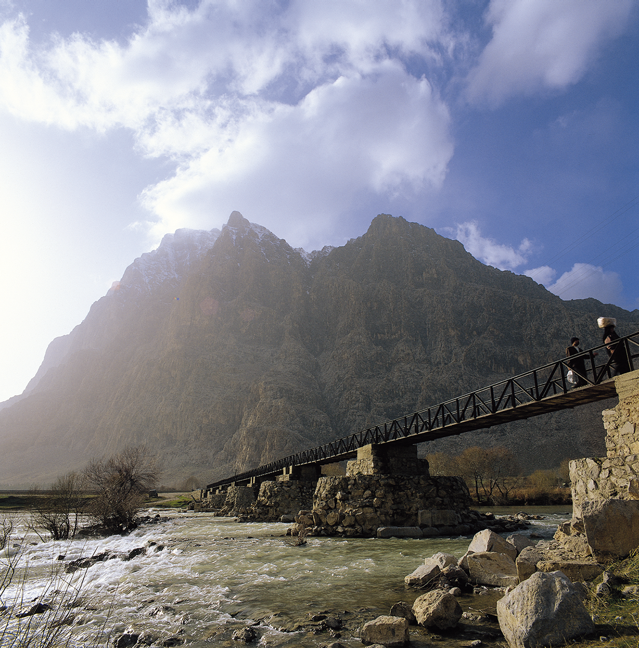
According to Abu-Dulaf’s description, this bridge was located between Bisotun and the village of Abi-Ayyub. Without mentioning its name, Abu-Dulaf writes about this bridge: ‘Below this place [Bisotun], there is a huge bridge of wonderful architecture spanning a deep river.’Footnote 6 According to Abu-Dulaf’s description, it seems that the connection between the historical settlement of Bisotun located on the northern bank of the Gamasiab River and the places located along the southern shore of the river was possible due to this bridge. Today, there are remains of nine stone foundations belonging to a Sassanid bridge in the Gamasiab River, less than 1 km south of the historical site of Bisotun. This monument, known as Pul-i Khosrow (Khosrow’s Bridge), is about 152 m long and 6 m wide (Figure 4).Footnote 7 These remains probably belong to the same bridge that Abu-Dulaf refers to as ‘a huge bridge with a strange structure’.Footnote 8 If this is true, then the hypothesis that this bridge, like many of the Sassanian structures in this area, is an unfinished building,Footnote 9 cannot be correct. Kleiss surmised that Pul-i Khosrow had been left unfinished, as no remains of arches could be found in the riverbed.Footnote 10 However, now other factors, such as human interference and natural erosion, can be considered potential reasons for the disappearance of the bridge arches. It seems that this was the same ruined bridge that Eugène Flandin pointed out in 1845 on his way to Takht-i Shirin when he had to cross the Gamasiab with a horse due to the destruction of the bridge. Here, Flandin mentions the remains of a road built with precision and strength that, according to him, looked very old.Footnote 11 In 1966, Kleiss identified a section of a road leading to Khosrow’s Bridge, which was 7 m wide and was made of rubble and mortar. He attributed the road to the Sassanid period.Footnote 12 In general, although Abu-Dulaf did not mention the bridge’s name, perhaps this is the same bridge that other geographers such as Ibn-Khordadbeh and Qudama refer to as ‘Qantara al-Maryam’.Footnote 13
The Bisotun Mount, the Gamasiab River, and the bridge known as Pul-i Khosrow, which includes remnants of the Sassanid piers with a metal deck from the contemporary era.

Abi-Ayyub
The name of this place is mentioned in Islamic geographical texts in various forms such as Abi-Ayyub, Abu-Ayyub, Aba-Ayyub, and Ba-Ayyub. Al-Idrisi referred to it as Qantara (bridge) Abi-Ayyub,Footnote 14 a title not mentioned in other sources. Since Abi-Ayyub was the first important place on the southern road after crossing the Bisotun Bridge, it is likely that Qantara Abi-Ayyub is the same bridge referred to by Abu-Dulaf, now called Khosrow’s Bridge. According to Abu-Dulaf, ‘from this bridge [Bisotun], one travels to a large village, rich and abounding in amenities, called Abu-Ayyub. It belonged to Jurhum whose patronymic was Abu-Ayyub, and he was its builder.’Footnote 15
Ibn-Rustah also writes: ‘There is a wide valley at the foot of Mount Behistun [Bisotun], with a spring next to it. Its water is able to turn five millstones and flows through a stone channel until it reaches Abi-Ayyub. The road here is positioned in a way that the shadow of Mount Behistun falls on it in the evening. Then the road continues until it reaches Dukkan.’Footnote 16 It seems that the spring being discussed is the same Sarab-i Bisotun, which is located downstream of the inscription of Darius I and the Parthian reliefs. The transfer of water from Sarab-i Bisotun on the northern bank of the Gamasiab to Abi-Ayyub on the southern bank through a stone channel is an interesting matter that has not been previously explored by researchers. This issue becomes more intriguing when we consider that in the famous love story of Khosrow and Shirin, expressed as a beautiful poem by Nizami Ganjavi (d. 1209), there is a clue about this stone channel. According to the story, Farhad, a stonemason who fell in love with Shirin, the wife of Khosrow Parviz, dug a stone channel to bring milk from the sheep herd at the foothills of Bisotun Mountain to Shirin’s palace, which was located at a distance of one to two farsakh away.Footnote 17 The author believes that this love story probably originates from folk imaginations inspired by the stone channel remnants that were previously described by Ibn-Rustah. It seems that the channel was actually designed to transport water from Sarab-i Bisotun to Abi-Ayyub, where the royal buildings were located on the southern bank of the Gamasiab. However, in later times, especially during the middle Islamic period, legends may have emerged around the remains of this channel due to its erosion and destruction over time.
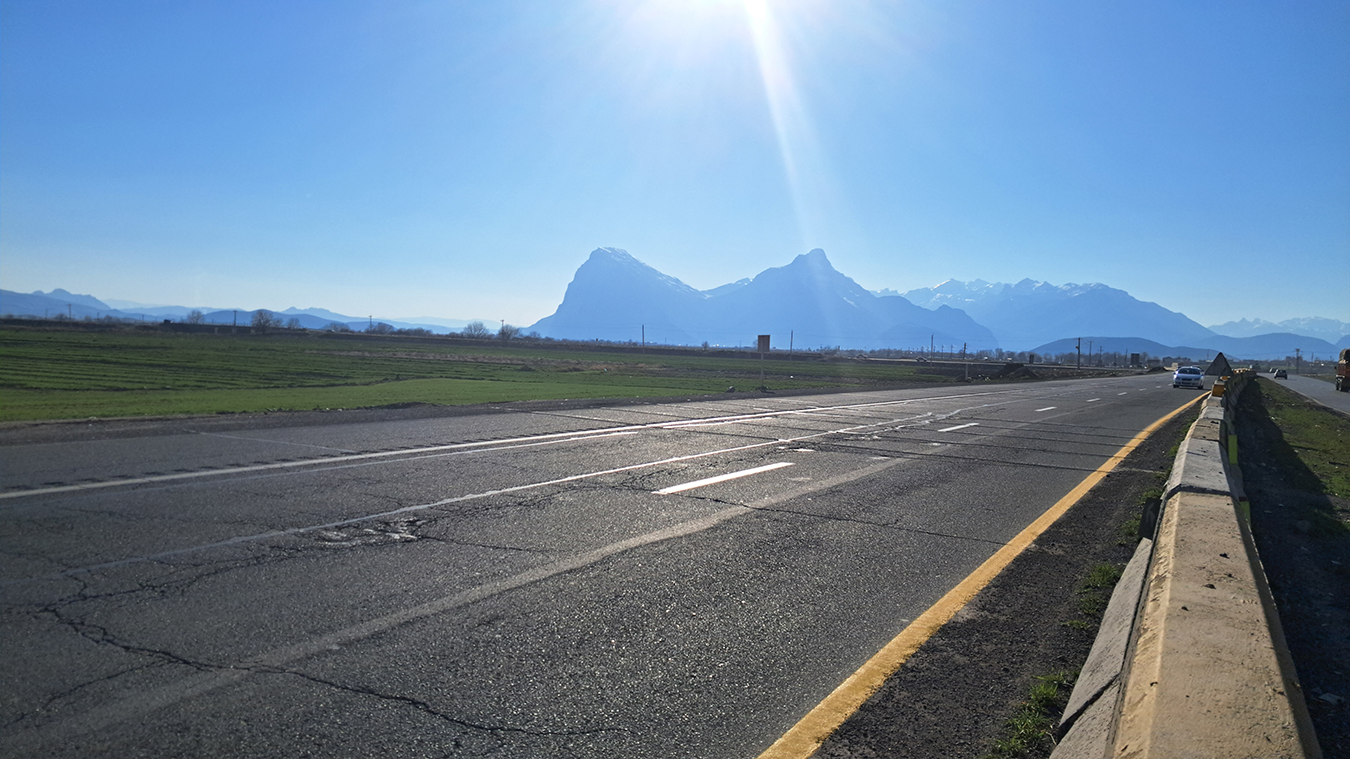
In general, in historical and mythical narratives of the Islamic and pre-Islamic periods, the significant presence of a woman is always seen around the name and circumstances of Mount Bisotun, which is remarkable and indicates that this issue has a historical root. In the Islamic era, the names ShirinFootnote 18 and Somayra,Footnote 19 and in the pre-Islamic era, the name SemiramisFootnote 20 are mentioned in relation to Bisotun. Additionally, Ernst Herzfeld believed that in the second millennium BC, the mount belonged to Šimalia, one of the goddesses worshipped by the Kassites.Footnote 21 Even today, Mount Bisotun and its adjacent peak can be seen from a distance to the east in the form of a sleeping woman, known by locals as ‘Shirin-i Khofteh’ (Sleeping Shirin). This view and its surrounding mentality could hold an important historical secret about the fundamental connection between Mount Bisotun and a woman/goddess (Figure 5).
The view of Mount Bisotun from the east, resembling a sleeping woman, is locally referred to as Shirin-i Khofteh.

It is inferred from the Nizami descriptionFootnote 22 that the channel was created by adjacent stone blocks with a channel in the middle. In the 1970s, Mehdi Rahbar, the Iranian archaeologist, identified the remains of a stone channel known as Jui i Khosrowi (Khosrow channel) in the same area, near the village of Bizinabad, and attributed it to the Safavid period.Footnote 23 Regarding this dating, we cannot attribute this channel to the intended channel of Ibn-Rustah. However, in the waqf-nameh-ye Bisotun (endowment inscription), attributed to Shaykh Alikhan Zanganeh (d. 1689), the ‘Qarawali channel’ is mentioned, and in its paper version, the phrase ‘old channel and new channel’ is used. It seems that the new channel, probably the same Qarawali channel, was built during the Safavid period in the Bisotun plain, while the old channel was built before that, perhaps during the Sassanid period. However, the localisation of Abi-Ayyub is closely linked to the identification and localisation of another building known as Dukkan, which will be discussed in the next section.
Dukkan
According to Islamic geographers, Dukkan was the most famous place or building situated along the southern route. Ibn-Rustah writes: ‘Dukkan is one of the Khosrowan [kings’] works, which is made of plaster and brick, on a stone platform. Its length and width are 400 cubits, carpeted with marble. There is a river flowing around it, used for fields and residents.’Footnote 24 From Ibn-Rustah’s description, it is inferred that the main part of Dukkan was built of bricks, while it was erected on a large platform of stone blocks. In addition, it is likely that the river used for field irrigation and residents’ consumption was the same Sassanian stone channel of Sarab-i Bisotun mentioned earlier. Another detailed description of Dukkan is provided by Ibn-Faqih Hamadani (tenth century), who writes: ‘In Qarmisin [Kermanshah], there is Dukkan, where the kings of the world, Faghfur, the king of China, Khaqan, the king of Turk, Dahir, the king of India, and Ghaisar (Caesar), the king of Rome, came to visit Khosrow Parviz. Dukkan is a square-shaped stone building that is 100 cubits long, constructed delicately and stably, strengthened with iron nails so that there are no gaps between the stones.’Footnote 25 Ibn-Faqih then narrates an interesting piece of poetry from Ahmad Ibn Muhammad, who describes Dukkan as follows:
Between Qanatir and Dukkan, there are buildings that are superior to all other structures. Dukkan is made of stone and sits on top of a hill. It is unclear whether it was built for fairies or humans. The stone used is smooth, of exceptional quality, and displays a variety of colours. The construction is so precise and seamless on the pillars that the secret of this craftsmanship is not only hidden from fairies. It is said that the kings of the world gathered at Dukkan to meet Parviz bin Sasan.Footnote 26
Regardless of the significant difference in the dimensions and size of the building in the two narrations, there is no mention of using bricks in the construction of Dukkan in Ibn-Faqih’s account. In fact, his description is such that the entire building appears to be made of carved stone blocks. In addition, the term ‘Qanatir’ (bridges) is used here in a plural form, which raises questions. It is possible that the phrase ‘buildings between Qanatir and Dukkan’ refers to structures located between two bridges, Pul-i Khosrow in the west and Qantara al-Nu’man in the east.
Overall, while most geographers of the ninth and tenth centuries have mentioned Dukkan and its distance from surrounding areas, none of their descriptions pinpoint the exact location of Dukkan along the southern route. One reason for this ambiguity is the varying distances mentioned between Dukkan and its neighbouring places by different geographers. For example, Ibn-Rustah reports the distance between Dukkan and Kermanshah as six farsakh, while Qudama cites it as seven farsakh. Similarly, Ibn-Rustah notes the distance between Dukkan and Qasr al-Lusus (Kangavar) as seven farsakh,Footnote 27 whereas Qudama mentioned it as nine farsakh.Footnote 28 Moreover, discrepancies and errors may be related to primary manuscripts. For example, in one version of Ibn-Khordadbeh’s al-Masalik wa al-Mamalik, the distance between Dukkan and Qasr al-Lusus is recorded as seven farsakh on one page and as nine farsakh on another page.Footnote 29
From Ibn-Rustah’s description, it is inferred that Dukkan was an independent place from Abi-Ayyub, though this conclusion is not certain due to his ambiguous statement. According to Abu-Dulaf, ‘Beyond the village of Abi-Ayyub, known as Dukkan, there lies at a farsakh’s distance, a village in which there is a lake that is insignificant to look at but is bottomless and they say that a Persian king was drowned in it.’Footnote 30 Abu-Dulaf then describes a story about the unsuccessful attempt of the king’s mother to find her son’s corpse. At the end of the story, she made a futile attempt to fill in the lake.Footnote 31 Minorsky locates the lake near the modern village of Mal-Amiri.Footnote 32 However, the significant point here is that, according to Abu-Dulaf, Abi-Ayyub and Dukkan were simply different names for one place.
Yaqut al-Hamawi and al-Baghdadi, who lived a few centuries after Abu-Dulaf, also consider these two places as the same and write: ‘Ba-Ayyub is an abbreviation of Abi-Ayyub and is a large village located between Qarmisin [Kermanshah] and Hamadan on the right side of the Baghdad road which is known as Dukkan.’Footnote 33 Therefore, we can assume that in the early Islamic period, the names Abi-Ayyub and Dukkan both referred to one place, or at least the royal building of Dukkan was located near Abi-Ayyub, a prosperous and famous village at that time (ninth and tenth centuries).
According to Abu-Dulaf, ‘Here [Abi-Ayyub] stands a huge platform built of unhewn stones. Some of the latter have been removed by a Kurd who has built with them a huge fortress called Sarmaj on the mountain overshadowing the village.’Footnote 34 If Minorsky’s identification of this huge platform as Dukkan is correct,Footnote 35 then it seems that Ibn-Faqih’s description of Dukkan likely predates its destruction,Footnote 36 while Abu-Dulaf’s description reflects the aftermath of its destruction when its stones were transferred to Sarmaj. If this assumption is correct, then regarding the time of Abu-Dulaf’s trip to Iran (943–952), it seems that this transfer didn’t take place during the reign of Badr Hasanoya (979–1014) as Minorsky has proposedFootnote 37 but during the reign of the first Hasnavian ruler, Amir Hossein Barzikani (942–959), or possibly even earlier, during the rule of the local dynasty of Ishaniyah (912–942).
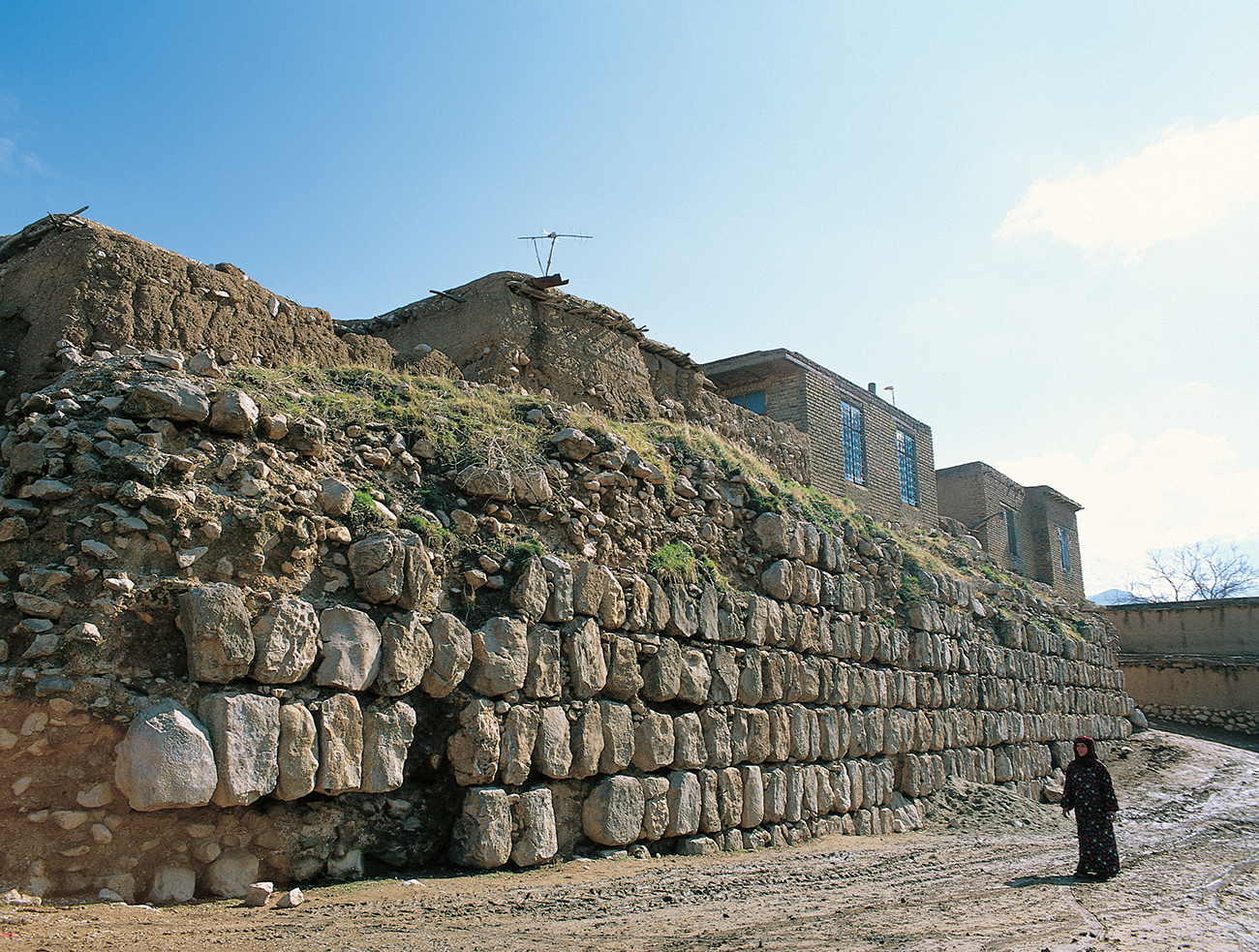
Sarmaj, whose name is mentioned by historians and geographers as the centre of the Hasanoya Dynasty in the tenth and eleventh centuries,Footnote 38 is located about 10 km south-east of Bisotun. In Sarmaj, there are the remains of a stone structure with dimensions of about 295 m by 288 m, situated on top of a natural hill, parts of which are hidden beneath the current village (Figure 6).Footnote 39 Heinz Luschey, followed by Leo Trümpelmann and Yousef Moradi believe that the Sarmaj building was built during the reign of Khosrow II (590–628) and is probably the remains of the same building that the Arab geographers mentioned as ‘Dukkan’.Footnote 40 Mohammad Eghbal Chehri and Ramin Chehri also believe that in Sarmaj there was a castle remnant from the Sassanid period. However, during the early Islamic period, a similar castle was built over it, where several Kufic inscriptions on hewn stones from this era have been found.Footnote 41
The remains of Sarmaj castle and the hewn stones used in its wall.

However, the author agrees with Minorsky that Dukkan should be sought somewhere in the north of Sarmaj, nearby on the highway, and closer to the southern bank of the Gamasiab.Footnote 42 In fact, the Sarmaj building cannot be the same as Dukkan in Islamic texts because, firstly, none of the geographers of the Islamic era imply that Dukkan and Sarmaj are the same, but they clearly specify that Abi-Ayyub and Dukkan were one place. Secondly, Abu-Dulaf’s writing clearly states that Sarmaj was another separate building that was built as a result of the transfer of stones from a building in Abi-Ayyub (probably Dukkan). The investigation by the German delegation in Sarmaj indicated that the carved stone blocks used here are superior in terms of elegance to all the Sassanid stone works such as the Bishapour fire temple, Firuzabad, Khosrow’s Bridge, and Taq-i Gara. This finding is reminiscent of Ibn-Faqih’s description of Dukkan and supports the Abu-Dulaf narration that the stone blocks of Sarmaj were originally part of the Sassanid building Dukkan before being moved to Sarmaj during the early Islamic period. Therefore, while on the one hand, Sarmaj and Dukkan were definitely two separate places, and on the other hand, Abi-Ayyub and Dukkan were probably two names for one place or at least two related nearby places, further research is needed to explore the potential connection between the current remains of the ancient site known as Takht-i Shirin and the historical place of Dukkan.
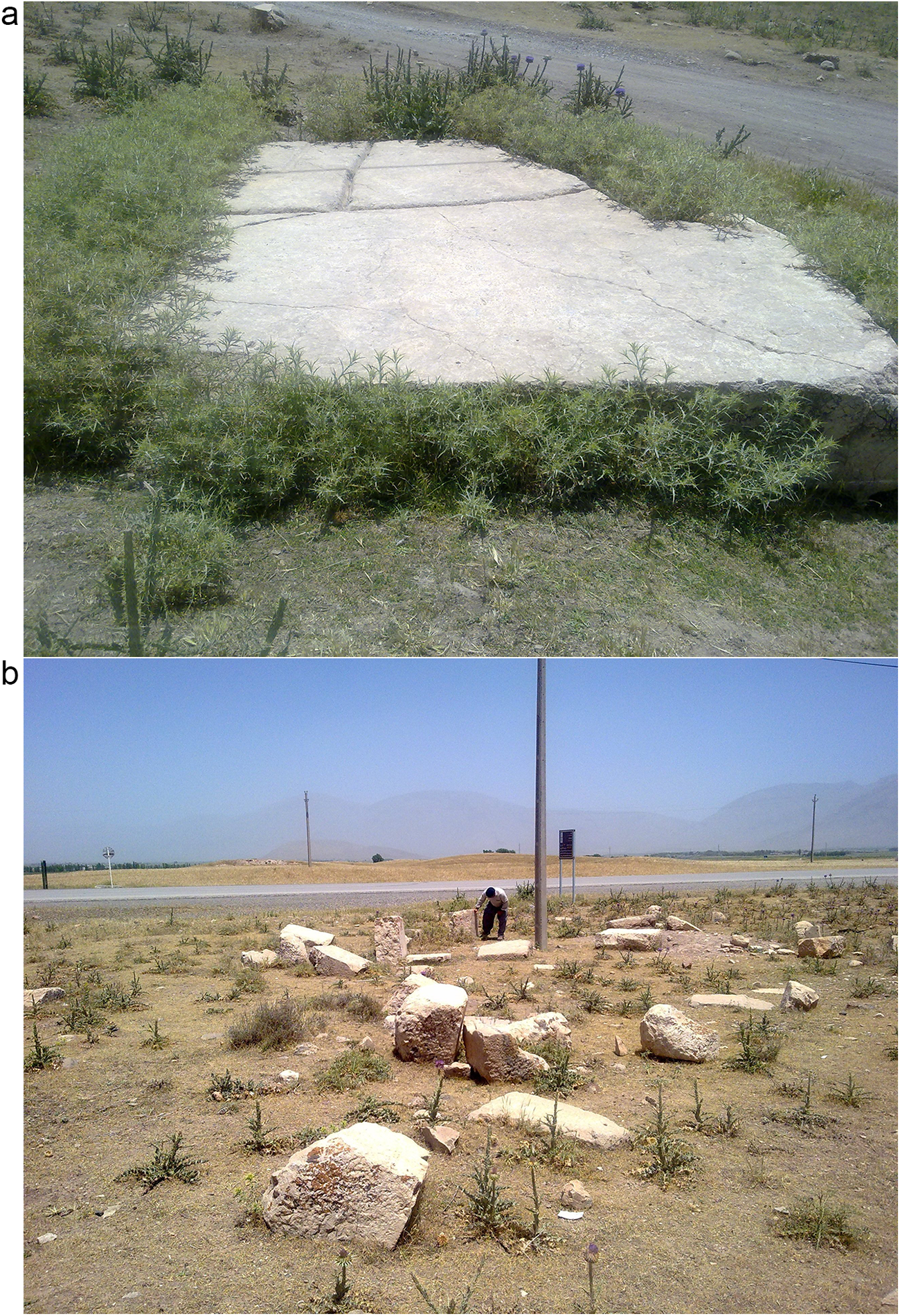
Flandin was one of the first researchers to visit Takht-i Shirin and described it as a platform made of large stones with scattered remains of columns similar to those at Bisotun (Figure 7).Footnote 43 Herzfeld and subsequently Minorsky identified Dukkan as present-day Takht-i Shirin.Footnote 44 Certainly, finding the definitive correspondence between Takht-i Shirin and Dukkan requires more evidence, which will be obtained through future archaeological excavations at this site. Currently, due to the existence of undeniable archaeological evidence, such as Takht-i Shirin, which is located along the proposed route, we assume that Dukkan corresponds to Takht-i Shirin. If this assumption is correct, then as al-Hamawi and al-Baghdadi have written, Dukkan was located on the right side of the Baghdad road.
The remains of Takht-i Shirin and its related hewn stones.

Nu’man Bridge (Qantara al-Nu’mana)
According to Islamic geographers, Nu’man Bridge (Qantara al-Nu’man) was located after Abi-Ayyub, on the way from Bisotun to Madharan and Qasr al-Lusus (Kangavar). According to Abu-Dulaf, the bridge was larger than all those already described and made of more solid workmanship.Footnote 45 If we assume that Abu-Dulaf compares this bridge with Pul-i Khosrow, which is about 150 m long, then the significant dimensions of Nu’man Bridge will appear. Abu-Dulaf attributes the construction of the bridge to Nu’man Ibn Mundhir, the famous Arab ruler who was contemporary with the late Sassanid period. He describes a detailed story in which Nu’man Ibn Mundhir was once a guest of Chosroes Abarviz [Khosrow Parviz], and there he encountered an incident that made him vow to build a bridge at that place.Footnote 46 However, as Minorsky also believes, the authenticity of this narration is doubtful.Footnote 47 Most likely, the more accurate narration is from al-Baladhuri (d. 892), who writes: ‘Nu’man Bridges are attributed to Nu’man bin ʿAmru bin Muqran Muzni because he had a military camp near these bridges which had been there for a long time.’Footnote 48 Although it is not clear why al-Baladhuri used the plural form of the word ‘Qanatir’ (bridges), it is inferred from his narration that the bridge belonged to the pre-Islamic period, probably the Sassanid era. It is inferred from his report that during the Muslims’ campaign to Iran, a group of them under the command of Nu’man bin ʿAmru camped around this bridge for a while before attacking Nahavand. On this occasion, it was called Nu’man Bridge. Yaqut al-Hamawi mentions both narrations about Nu’man Bridge.Footnote 49
According to al-Maqdisi (d. 991), ‘from Qasr al-Lusus to Qantara al-Nu’man is one stage, then to Mount Bisotun is one stage’.Footnote 50 Based on this, Minorsky believed that Nu’man Bridge stood halfway between Bisotun and Qasr al-Lusus (Kangavar);Footnote 51 it must be looked for immediately west of Sahneh (Ṣaḥna). The Minorsky localisation was based on the assumption that the old road referred to by Abu-Dulaf crossed the southern bank of the Gamasiab River via the current road from Chambatan to Takht-i Shirin and Mahmudabad, and then returned to the north bank before Sahneh.Footnote 52 Based on this assumption, he searched for other places such as Dastjird-Kisrawiya, Valashjird, or Madharan along the northern route, on the path from Sahneh to Bid-i Surkh Pass.
While most geographers only refer to the Qantara (bridge) al-Nu’man, Ibn-Rustah mentions the village of Nu’manyah that was located immediately after the bridge, logically, on the other side of the Gamasiab River. Al-Idrisi also referred to Qantara al-Nu’man as a small valley (wad),Footnote 53 indicating that this place was not located in the plain but along a mountain valley that served as the course of the river (Gamasiab). Based on this information and the four-farsakh distance between Qantara al-Nu’man and Abi-Ayyub, as well as the location of Nu’man Bridge over the Gamasiab River and the village of Nu’manyah on the north bank of the river, the author locates Nu’man Bridge in the continuation of the southern route, somewhere around the current village of Derekeh. Here, at a distance of 400 m south of Derekeh, there is a prehistoric and historic mound registered as site No. 12199 on the National Heritage List of Iran, which could be a potential location for the old village of Nu’manyah.
In addition, the author believes that Derekeh and its ancient mound most probably correspond to ‘Darathe’ on the ‘Tabula Peutingeriana’, an old map that depicts the global road network of the Roman empire period. On this map, Darathe is located just before ‘Concobas’ in the region known as ‘Madobalani’.Footnote 54 As researchers believe, Concobas is the same as Concobar in Isidore’s text (present-day Kangavar),Footnote 55 and Madobalani is the same Iranian term ‘Mad-i Bala’, which means Upper Media.Footnote 56
Regarding the topography of the region, from Nu’manyah (according to the author, ancient Darathe), travellers could move to the east (Kangavar or Nahavand) via two routes. The first route in a northern direction went to the current Sarab-i Bid-i Surkh, then after passing the Bid-i Surkh Pass, it reached Kangavar. It seems that Ibn-Rustah had passed through this branch of the route. The second route, in a south direction along the northern bank of the Gamasiab entered a mountain valley, which was consistent with al-Idrisi’s description. The two next places discussed in this research, Dastjird-Kisrawiya and Valashjird, mentioned by Abu-Dulaf, were located along the recent branch of the route. While Ibn-Rustah hasn’t mentioned it, it seems that at least Abu-Dulaf had passed through the recent road. Some evidence confirms the existence of this ancient route, including its west–east direction towards Nahavand, the presence of archaeological sites along the route, and the correspondence of the second old place, Valashjird, with a modern place of a similar name on the same route, which will be discussed in detail in its related section.
Dastjird-Kisrawiya
According to Abu-Dulaf, there was a place known as Dastjird-Kisrawiya situated somewhere after Nu’man Bridge. In the description of Abu-Dulaf, which is also recounted by Yaqut al-Hamawi, it is stated: ‘There are wonderful buildings consisting of lofty pavilions (jawasiq) and porticos, all made of blocks of squared stones, and the onlooker has no doubt that they have been hewn out of one piece.’Footnote 57 As can be seen, this description is somewhat reminiscent of Ibn-Faqih’s description of the building called Dukkan. The name Dastjird-Kisrawiya is the Arabic form of the Iranian name Dastgird-i Khosrawi. The title ‘Dastgerd’ is widely mentioned in Middle Iranian inscriptions.Footnote 58 In Islamic sources, several places are also mentioned with the name Dastgird or Dastjird.Footnote 59 Even today, more than 55 places in Iran have been identified with this name.Footnote 60
Wilhelm Tomaschek located Dastjird-Kisrawiya in Firozabad,Footnote 61 and Minorsky believed that this place is most likely Sahneh (Ṣaḥna), ‘a place of some importance, with Median rock-cut chambers in the adjoining gorge, and even the name Ṣaḥna points to some raised platform’.Footnote 62 However, these locations are unlikely, as Sahneh and its famous rock-cut tombs are located on the northern bank of the Gamasiab, far away from the southern route. In fact, for two simple reasons, Sahneh was never part of the route intended by geographers like Abu-Dulaf and Ibn-Rustah. Firstly, the name Sahneh is not mentioned in the aforementioned texts, even though Sahneh was a well-known place at that time (tenth century).Footnote 63 Secondly, if Sahneh had been included in the route, there would have been no requirement to cross the southern bank of the Gamasiab through places such as Pul-i Khosrow, Abi-Ayyub, and Dukkan because Sahneh could have been easily accessed via the road on the northern bank. As a result, Dastjird-Kisrawiya should be searched for along the southern route. Regarding our suggested route and the position of Dastjird-Kisrawiya, which was located after Nu’man Bridge and Nu’manyah, the author believes that this place was probably situated somewhere around the current village of Garus. Here, two historical hills, including Tape Garus-i Sufla as site No. 11830 and Tape Darband Garus-i Sofla as No. 12188, have been registered in the National Heritage List of Iran. While the remains of any stone structures have not been reported from the Garus village, we will have to wait for future excavations in this place for any definitive statement.
Valashjird
According to Abu-Dulaf, Valashjird was the following place on the southern route, situated after Dastjird-Kisrawiya. He writes: ‘It is said to have 1,000 springs, the waters of which form one single river.’Footnote 64 Tomaschek, probably based on the similarity of names, considered Valashjird to be the same as the current Valashgird in the east of Kangavar.Footnote 65 This localisation is not accurate because, firstly, Valashjird was a common name used for multiple places as noted by al-Hamawi and al-Baghdadi.Footnote 66 Secondly, Abu-Dulaf’s account places Valashjird before Qasr al-Lusus (Kangavar), somewhere in its western part.Footnote 67 Minorsky suggests that Valashjird could be the same as Sarab-i Bid-i Surkh.Footnote 68 Regarding the path of the southern route along the Gamasiab valley, the author believes that Valashjird was located somewhere around the current village of Duab, perhaps in the location of the village of Duab itself. Acceptable evidence strengthens the possibility of this localisation. At a distance of about 1 km south of Duab village, there is a mountain called Valazgird, which most likely has taken its name from the nearby ancient settlement of Valashjird. Minorsky considered Valashjird to probably be an Arsakid (Parthian) name.Footnote 69 Duab village has a historical mound with the Parthian layer known as Tepeh Duab 2 K-116, registered as No. 6637 in the National Heritage List of Iran. Furthermore, the abundance of water sources in the Duab area aligns with Abu-Dulaf’s description, who reports Valashjird as a water-rich location. As the name of this place (Duab = ‘two waters’) indicates, it is located at the confluence of the rivers Khurram-Rud and Sarab-i Maran, which also join the Gamasiab River about 400 m south of the village. In addition, there are numerous springs and mirages within a radius of 5 km around Duab village, some of which are Kiani Mau, Sarab Garmeh, Cheshmeh-Drazeh, Khalaj-Rud, Sarab-i Baba Ali, Kiani Aziz, Sarab-i Kangavar-i Kohneh, etc. All these flowing waters, after a short distance, join the Gamasiab River.
Madharan
Madharan is the last place on the southern route investigated in this research. According to Abu-Dulaf, Madharan was located after Valashjird.Footnote 70 Also, according to Yaqut al-Hamawi, Madharan is the abbreviation of KusMadharan, a term that is not found in older sources.Footnote 71 Perhaps ‘Kus’ is a shortened form of the old term ‘Kust’, meaning ‘region’. Abu-Dulaf writes: ‘Madharan is a lake with an abundant outflow which drives 100 mills, widely scattered and of various descriptions. Nearby stands a lofty castle of Chosroes [Khosrow], and in front of it, there is a sloping bank (zallaqa: glacis) and a large orchard.’Footnote 72 This description has also been repeated by Yaqut.Footnote 73 In addition, al-Baladhuri mentions a castle in this place and writes: ‘The castle known as Madharan is attributed to Siri Ibn Nasir Ibn Thaur Ajali. He fought there until he conquered the fortress.’Footnote 74 Yaqut and al-Baghdadi have also repeated the attribution to Siri.Footnote 75 Al-Idrisi also writes: ‘Madharan is a small town with mansions and industries.’Footnote 76
From the middle centuries of the Islamic era onwards, like the other places on this route, the name Madharan is no longer mentioned in the texts. For example, while al-Qazvini mentions a Madharan in Damghan, he does not make any reference to Madharan of Jibal.Footnote 77 However, when comparing Madharan’s location to other places on the southern route, earlier sources provide more information. Qudama considered Madharan as an area belonging to Dinawar.Footnote 78 According to Yaqut al-Hamawi, the distance from Valastjird to Madharan is one stage, and from there the road leads to Qasr al-Lusus (Kangavar).Footnote 79 Qudama and Ibn-Khordadbeh both state that the distance between Madharan and Nahavand is equivalent to three stages.Footnote 80 Ibn-Khordadbeh and al-Istakhri have mentioned the distance from Madharan to Sahneh as four farsakh.Footnote 81 However, the distance between Madharan and Qasr al-Lusus (Kangavar) has been reported differently by geographers, and sometimes even within different versions of a geographer’s book. For example, according to Ibn-Hawqal and a version of al-Istakhri’s book, the distance between Madharan and Qasr al-Lusus is seven farsakh,Footnote 82 while in another version by the same geographer, this distance is mentioned as four farsakh.Footnote 83 Al-Idrisi mentioned the same distance as 12 miles, which is approximately equivalent to four farsakh.
Ibn-Khordadbeh, Ibn-Rustah, and al-Idrisi write in a similar text: ‘Whoever is going to Nahavand and Isfahan moves to the right from Dukkan to reach Madharan and then to Nahavand, which is one of the Kureh (regions) of Jibal.’Footnote 84 Perhaps the most complete description of the route leading to Madharan belongs to Ibn-Rustah, who writes: ‘From Dukkan to Qasr al-Lusus is seven farsakh. It is an up-and-down road that goes through the mountains and reaches Nu’man Bridge and the village of Nu’manyah. Then it continues to Madharan’s Pass. On the left side of this road, there are irrigated fields, and from there, the road leads to the end of the valley. After crossing a bridge, it reaches Qasr al-Lusus.’Footnote 85
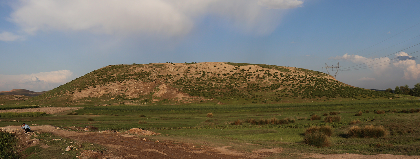
Tomaschek located Madharan in Minderabad (Vandarabad),Footnote 86 but Minorsky rejected this location and instead suggested Sarab-i Bid-i Surkh for Madharan.Footnote 87 Considering all the determining factors, including our suggested route, the author believes that the most suitable option for the location of ancient Madharan is one of the two adjacent sites of Tape Paqal’e Dehlur (Figure 8) and Tape Sarab-i Maran located in the west Khezel district, which are registered as No. 7002 and No. 8132, respectively, on the National Heritage List of Iran. According to al-Istakhri, the road from Hamadan to Dinawar passed through Madharan, then went to Sahneh and Dinawar.Footnote 88 This description matches our proposed location for Madharan in Sarab-i Maran, as it is located on the road between Hamadan, Sahneh and Dinawar. The distance between Sarab-i Maran (Madharan, according to the author) and Sahneh is about 23 km, which also corresponds to the four-farsakh distance reported by geographers for these two places.
Tape Paqal’e Dehlur.

In fact, it seems that Ibn-Rustah’s route, which didn’t include Dastjird-Kisrawiya and Valashjird, and went directly from the Nu’man Bridge to Madharan, coincides with the first branch of the author’s proposed route, where the route goes from the current village of Derekeh to Bid-i Surkh and then to Sarab-i Maran. In addition, the Arabic word Buhaira (lake, pond, wetland, marsh), used by Arab geographers to refer to Madharan,Footnote 89 most probably refers to Sarab-i Maran. As Minorsky mentions, sarab is ‘the source of a stream, usually a system of springs and pools’.Footnote 90 With this explanation, the author would like to suggest that the name ‘Maran’ is most likely rooted in the old name Madharan. Additionally, due to the location of Sarab-i Maran, which was situated right at the beginning of the ancient region known as Upper Media, on the eastern slope of the present-day Bid-i Surkh heights,Footnote 91 the author believes that the name Madharan is probably derived from the ancient name Media (OPers. Mada).Footnote 92
A very important point of this discussion is Ibn-Rustah’s reference to the pass (ʿaqaba) of Madharan, which, according to the author, was a title attributed to the current Bid-i Surkh Pass during the early Islamic period. The current name Bid-i Surkh Pass (Gardaneh-ye Bid-i Surkh) derives from the name of the village Bid-i Surkh, located on the western slope of these heights, and has become prevalent in recent centuries. However, it seems that in the early Islamic period, the name of this pass was taken from the name Madharan (now Sarab-i Maran), which was located on the eastern slope of the heights. A traveller who reached Madharan from the west went from there to Qasr al-Lusus (Kangavar) by entering the present-day Kangavar–Sahneh road. If they intended to travel to Nahavand as well, they turned south along the present-day Kangavar–Nahavand road.
Conclusion
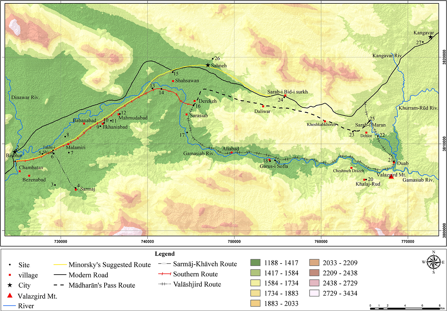
Based on historical and archaeological evidence, a branch of the old road that passed along the southern bank of the Gamasiab River in the Bisotun–Sahneh plain was very important during the Sassanid and early Islamic periods. This research is dedicated to reidentification of the route and localisation of the seven old toponyms along it, including Bisotun Bridge, Abi-Ayyub, Dukkan, Qantara al-Nu’man, Dastjird-Kisrawiya, Valashjird, and Madharan. The author believes that this road was divided into two branches in the area of Takht-i Shirin. One branch turned to the right and went to Sarmaj, then continued to the Khaveh plain in the northern part of Lorestan, and finally reached Nahavand. The other branch, which is the subject of this research, continued along the southern bank of the Gamasiab. This road again divided into two branches somewhere near the present-day village of Derekeh (according to the author, Darathe in the Sassanid period). One branch went to the left and passed through the current heights of Bid-i Surkh (according to the author, Madharan’s Pass in the early Islamic texts), then continued to Madharan (according to the author, now Sarab-i Maran) and Kangavar (Qasr al-Lusus). Based on the details of the ‘Tabula Peutingeriana’ map, it seems that the route that passed through Darathe (current Derekeh) was the main route between Bisotun and Kangavar during the Sassanid period. Based on Islamic geographical texts, it seems that this route maintained its importance during the early Islamic period as well. The other branch of this route, which turned to the right from Derekeh, continued along the Gamasiab valley until it reached Dastjird-Kisrawiya and Valashjird (present-day Duab). In Valashjird, travellers could continue their route on the east bank of the Gamasiab River via a bridge towards Nahavand. Additionally, a traveller could reach Madharan from Valashjird by going a short distance via a north-west route and then proceeding to Kangavar (Figure 9). The use of each of these roads and their branches depended on various factors, including the season and the safety of the route, which could vary enormously and can perhaps help us understand the practicalities of travel.
A map showing the old routes, ancient sites, and modern places on the southern bank of the Gamasiab River in the Bisotun–Sahneh plain. 1. Pul i Khosrow 2. Pul i Safavi 3. Tapeh Jahanshah 4. Sarmaj Castle 5. Tapeh Pager 6. Tappeh Mohamadkarim 7. Tapeh Chalchiman 8. Tapeh Bozorg 9. Kharmanja 10. Barqachal 11. Espandku 12. Tuzijar 13. Tapeh Kazhdom 14. Seh-Tappan 15. Tapeh Mian Sarawan 16. Tapeh Derekeh 17. Tapeh Aqajan 18. Tapeh Darband i Garus 19. Tappeh Garus i Sofla 20. Khalaj Rud 21. Doab 22. Paqhal’e Dehlor 23. Tape Gandab 24. Tappeh Sarab i Bidsurkh 25. Tapeh Sarab I Maran 26. Sahneh rock cut tombs 27. Anahita temple.

Figure 9 Long description
The map displays the Bisotun–Sahneh plain, highlighting various routes, sites and elevation levels. The legend identifies different routes: Minorsky′s Suggested Route, Sarmaj-Kisheh Route, Modern Road, Southern Route and Valashjird Route. Symbols indicate sites, villages, cities and Valasgard Mountain. Elevation is categorized into ranges: 1188 to 1417, 1417 to 1644, 1644 to 1872, 1872 to 2100, 2100 to 2328, 2328 to 2556 and 2556 to 2784. The map shows the distribution of these routes and elevation levels across the region, with specific sites and villages marked along the routes. The river is also depicted, running through the area, providing a geographical reference point.
After a flourishing period during the Sassanid era until the first centuries of the Islamic era, the southern route eventually lost its importance from the middle of the Islamic era and gradually disappeared from historical texts, becoming a local route. The reason for this decline is not clear, but according to the author, a strong possibility is the presence of a deep and watery stretch of the Gamasiab along this route, which required long and sturdy bridges to cross, the implications of which required investment in infrastructure, etc. Probably due to the annual floods of the Gamasiab, these bridges, at least two of which are mentioned in historical sources (Pul-i Khosrow and Nu’man Bridges), both likely from the Sassanid period, needed attention, repairs, and maintenance. However, it seems that these needs were neglected by the governments, especially during the middle centuries of the Islamic era. As a result, the southern route was gradually entirely replaced by the northern road, which was easier to travel. Therefore, only a memory of the southern route remains in historical texts.
Acknowledgements
The author thanks Dr Sajjad Alibaigi, Dr Mohammad Eghbal Chehri, and Abbas Bavarsaee for their assistance in completing the archive of photographs required for the article.
Conflicts of interest
None.