Introduction
Byers Peninsula (62°34′S, 61°13′W) is a protected area of 84.7 km2 in the west of Livingston Island, South Shetland Islands. Climate in the region is characterized by average summer temperatures slightly above freezing point. Precipitation is relatively high with 800 mm per year, mostly as rain in summer (Ellis-Evans Reference Ellis-Evans1996), and winds are moderate compared to other locations (Serrano Reference Serrano2003). As one of the largest areas of ice-free ground in the Antarctic Peninsula (Richard et al. Reference Richard, Convey and Block1994), it contains a remarkable variety of geological formations and ecosystems available for research.
The abundance of Antarctic fur seals (Arctocephalus gazella Peters) in this area attracted sealers in the early 19th century (Lewis Smith & Simpson Reference Lewis Smith and Simpson1987). However, the profitability of this activity was quickly reduced by systematic and uncontrolled hunting, and sealers soon left the area. In 1966, part of the Peninsula was designated as the Specially Protected Area (SPA) No. 10 by Recommendation IV-10 of the Antarctic Treaty Consultative Meeting (ATCM). The main aim was to conserve the biological values of the area, which included a high diversity of plant and animal life within a relatively small area. Designation as an SPA was changed in 1975 through Recommendation VIII-2, which redesignated the area as Site of Special Scientific Interest No. 6 (SSSI) (Recommendation VIII-4). The new designation protected three sites on the Peninsula where fossils provided evidence of the former link between other elements of Gondwana and Antarctica. The SSSI was subsequently extended through Recommendation XVI-5 (1991) to include boundaries similar to those of the original SPA, and protecting the scientific use of the biological and archaeological features of outstanding importance found in the Peninsula, in addition to the geological values previously cited. The protection status of the area changed again with its designation as an Antarctic Specially Protected Area (ASPA) No. 126 for the full site adopted in 2001 by Decision 1 (2002). The management plan was adopted by Measure 1 (2002) and recently revised by Measure 4 (2011). ASPA category may be applied both to terrestrial and marine areas to protect outstanding environmental, scientific, historic, aesthetic or wilderness values, any combination of those values, or ongoing or planned scientific research (Protocol on Environmental Protection to the Antarctic Treaty, Annex V, Article 3). As a result of this on-going protected status, human presence has been limited in the past 46 years to scientific activities which may have reduced direct human impact in the area and kept it free of human influence relative to other ice-free areas in the vicinity (e.g. Deception Island or Fildes Peninsula, King George Island). During the International Polar Year, Byers Peninsula was defined as an International Reference Site for research on terrestrial, limnetic and coastal ecosystems (Quesada et al. Reference Quesada, Camacho, Rochera and Velázquez2009).
The majority of ASPAs within the Antarctic Treaty area are small (with over 55% having an area of less than 5 km2) and many protect only a single or limited number of values (Hughes & Convey Reference Hughes and Convey2010). ASPA No. 126 Byers Peninsula does not fit this mould. Unusually for a predominantly ice-free terrestrial ASPA, it is of a much larger scale and contains one of the most diverse ranges of values considered to be worthy of protection within the ASPA network. A challenge to environmental managers is to ensure that Byers Peninsula is protected in a way that considers and facilitates conservation of all of the values within the area. Mainly, this is undertaken through the Byers Peninsula ASPA Management Plan, which has the United Kingdom, Chile and recently Spain as proponent Parties. The management plan describes the values to be protected as: i) the exceptional diversity of terrestrial flora and fauna, ii) the numerous lakes, freshwater pools and streams, iii) the invertebrate fauna, iv) the abundant cyanobacterial mats, v) the diverse breeding avifauna, vi) the lake sediments for use in palaeoenvironmental research, vii) the well preserved sub-fossil whale bones, and viii) the exposed Jurassic and Cretaceous sedimentary and fossiliferous strata.
The present study aims to i) serve as a compendium of Byers Peninsula science as a reference for future research, ii) analyse the diversity of investigations undertaken and the links between researchers, and iii) identify key aspects for practical conservation of the site. We reviewed all available scientific literature relating to this site, conducted a bibliometric study of the scientific output to identify international research cooperation between the Antarctic Treaty Parties then attempted to identify the emerging issues for practical environmental management and conservation at this site.
Material and methods
To fullfil these objectives an initial consultation was made of the bibliographic database Thomson's Scientific Citation Index (SCI). SCI is a widely accepted international citation system of more than 4000 peer-reviewed scientific and technical journals. Similar analyses to the present work have been made for Antartic science papers by Dastidar (Reference Dastidar2007). All published papers that included science on or about Byers Peninsula were included in this review. The list was filtered to determine which were directly related to active research in Byers Peninsula. From the original list we eliminated all those papers with no research directly conducted in Byers Peninsula, such as those that indirectly cited Byers Peninsula publications, for instance, by comparison of data from elsewhere with Byers Peninsula research findings. In addition, relevant documents from other sources were included in this review in order to summarize current knowledge of Byers Peninsula. We used different tools for their detection, such as the Cold Regions Bibliography Project (www.coldregions.org), and several databases included by Antarctic national programmes on their own websites. References in each selected work were reviewed to detect other studies developed on Byers Peninsula. Finally, some distinguished experts were asked to review and complete the list of identified publications.
Next, a bibliometric analysis was performed on those publications included in the indexed journals of SCI. It is important to recognize that several relevant works on Byers Peninsula may have published in journals not included in SCI. Eight thematic areas were defined based on the main research conducted by the scientific field expeditions. These were: i) Glaciology, Climate and Meteorology, ii) Geology and Stratigraphy, iii) Geomorphology and Soils, iv) Palaeontology, v) Terrestrial Biodiversity, vi) Limnology and Microbiology, and viii) the Human Dimension. Each article was allocated to one of the eight categories. Articles within this special issue have not been included in this analysis, although they may be considered a valuable reference for future research within Byers Peninsula. Changes in the level of scientific outputs were plotted by thematic area, and results were compared with article production across all of Antarctica over the same period. Techniques to determine the extent of collaboration between international researchers (Cross et al. Reference Cross, Borgatti and Parker2002) were used to analyse scientific articles with joint authorship within SCI. The collaboration networks between i) researchers, ii) institutions, and iii) nationalities were derived.
Science summaries from the published papers
Research on glaciology, climate and meteorology
Everett (Reference Everett1971) proposed at least three glacial events for Livingston Island, which had a decreasing intensity. The specific climate history and deglaciation chronology of Byers Peninsula have been described by several authors using lake sediments analysis. John & Sugden (Reference John and Sugden1971) proposed that Byers Peninsula was largely free of permanent ice by 9700 yr bp, whereas Björck et al. (Reference Björck, Sandgren and Zale1991a, Reference Björck, Håkansson, Olsson, Barnekow and Janssens1991c, 1993, Reference Björck, Hjort, Ingolfsson, Zale and Ising1996), Hjort et al. (Reference Hjort, Ingolfsson and Björck1992) and Björck & Zale (Reference Björck and Zale1996), suggested a more recent general deglaciation of central Byers Peninsula of around 4000–5000 yr bp. But Björck et al. (Reference Björck, Hjort, Ingolfsson and Skog1991b) pointed out the problems of 14C dating in Antarctica due to the reservoir effect and the need for a careful evaluation of the proposed radiocarbon dates. Other researchers have used ice rafted detritus from raised beach ridges on Byers Peninsula to analyse this issue (Hall & Perry Reference Hall and Perry2004). This material was used by Hall (Reference Hall2010) to determine the nature and timing of glacial and climate fluctuations in Antarctica relative to those in the rest of the Southern Hemisphere. Data showed a complex pattern characterized by ice transgressions over the area at ∼6000–7000 and ∼400 yr bp, which may have been linked to glacial advance. Other works have focused on earlier series of the Quaternary system. Hall (Reference Hall2003) reviewed ice fluctuations during the late Pleistocene glaciation in the South Shetland Islands, including data obtained on Byers Peninsula. Recent studies suggest the deglaciation of some capes and peninsulas at around 9500 yr bp, a regional advance between 6000 and 4500 yr bp (Hall Reference Hall2009, Michalchuck et al. Reference Michalchuck, Anderson, Wellner, Manley, Majewski and Bohaty2009) and a last small advance of ice domes and ice occupying the cirques during the Little Ice Age (López-Martínez et al. Reference López-Martínez, Serrano, Schmid, Mink and Linés2012). Growth rings in Cretaceous and Tertiary wood from different sampling sites, including Byers Peninsula, were also used by Francis (Reference Francis1986) to analyse the climate in those periods.
Current meteorology at this site was described by Bañón (Reference Bañón2004) and Bañón et al. (Reference Bañón, Justel and Quesada2006) highlighted a higher temperature on Byers Peninsula compared with other very close locations (e.g. Juan Carlos I Station) and proposed the existence of a warmer microclimate, with both average temperatures over 0°C and abundant precipitation as rain in summer. Before these publications, descriptions of Byers Peninsula climate were generally vague (i.e. Ellis-Evans 1996, Serrano Reference Serrano2003), or were very specific studies such as those conducted by Hall (Reference Hall1992a, Reference Hall1992b, Reference Hall1993a, Reference Hall1993b), who analysed the relationship of various rock surface temperatures to local climatic conditions and the annual number of air freeze-thaw cycles in summer. Rochera et al. (Reference Rochera, Justel, Fernández-Valiente, Bañón, Rico, Toro, Camacho and Quesada2010) pointed out that inter-annual variation in the meteorological conditions at this site could be significant, acting as a triggering factor for some limnological processes. The latest contribution by Bañón et al. (Reference Bañón, Justel, Velázquez and Quesada2013), proposed the use of regional weather data for landscape studies within Maritime Antarctica on the basis of their research on Byers Peninsula.
Geology and stratigraphy
To the best of our knowledge, the first reconnaissance geological survey of Byers Peninsula was carried out by Hobbs (Reference Hobbs1968), who described agglomerates near Start Point and andesite lavas with interbedded sediments on the northern shores of New Plymouth. Hobbs attributed the rocks of this location to the Oligocene, probably because these agglomeratic rocks were petrographically similar to some from Point Hennequin, King George Island (Thomson Reference Thomson1992). The discovery of ammonites (Spitceras) belonging to the upper Titonian to Neocomian by González-Ferrán et al. (Reference González-Ferrán, Katsui and Tavera1970) on the coast of President Beaches eventually proved that parts, at least, were Early Cretaceous in age. Dalziel et al. (Reference Dalziel, Price and Stirewalt1970) also demonstrated the presence of Mesozoic rocks through the analysis of the ammonite fauna in sediments. Valenzuela & Hervé (Reference Valenzuela and Hervé1972) divided the Byers Peninsula into two areas. A “younger unit”, composed mostly of agglomerates, overlies the “older unit” which is a fossiliferous sedimentary sequence, grading laterally from west to east, from marine to continental facies. These authors also produced the first 1:20 000 geological map of Byers Peninsula and described some patterned ground shapes. This proposal was extended by Pankhurst et al. (Reference Pankhurst, Weaver, Brook and Saunders1979), who suggest that the unfossiliferous “younger unit” described by Valenzuela & Hervé (Reference Valenzuela and Hervé1972) is in part a time correlative of the upper (non-marine) facies of the “older unit”. Lava flows and intrusions in the main non-marine outcrop are of Lower Cretaceous age, and igneous activity on Byers Peninsula concluded with dolerite plug and sill formation in Upper Cretaceous times. Pankhurst et al. (Reference Pankhurst, Weaver, Brook and Saunders1979) reported K–Ar ages within the range 126–75 Ma from igneous rocks sampled on Byers Peninsula and provided a second geological sketch map. This geochronology was supported by further discoveries of Berriasian and Valanginian ammonite faunas at many localities throughout western and north-east Byers Peninsula (e.g. Hernández & Azcárate Reference Hernández and Azcárate1971, Covacevich Reference Covacevich1976, Smellie et al. Reference Smellie, Davies and Thomson1980, Askin Reference Askin1983). Gracanin (Reference Gracanin1983) suggested that certain strata of Byers Peninsula were much older (Oxfordian) than previously reported (143±5 Ma). At that time, Hansom (Reference Hansom1979) obtained a radiocarbon age of between 2100 and 2400 yr bp for skeletal material from the 10 m high beach ridge at South Beaches, whereas the lowest beach deposits were dated at 300 yr bp (John & Sugden Reference John and Sugden1971, Sugden & John Reference Sugden and John1973).
Smellie et al. (Reference Smellie, Davies and Thomson1980) studied the geology of this site and assign the Byers Peninsula succession to a single major unit, the Byers Formation, which they divided into four members: Mudstone, Mixed Marine, Agglomerate, and Volcanic (Thomson Reference Thomson1992, Machado et al. Reference Machado, Lima, Chemale, Morata, Oteiza, Almeida, Figuereido, Alexandre and Urrutia2005a). Lower Cretaceous rocks at Byers Peninsula were examined by Watts et al. (Reference Watts, Watts and Bramall1984), Grunow (Reference Grunow1993), and Poblete et al. (Reference Poblete, Arriagada, Roperch, Astudillo, Hervé, Kraus and Le-Roux2011), showing uncertainties in the exact age of the main event of remagnetization, which could have been acquired during the Cretaceous Normal Chron. Crame et al. (Reference Crame, Pirrie, Crampton and Duane1993) reviewed the previous stratigraphical work on Byers Peninsula and elevated Byers Peninsula to group status, dividing the strata previously assigned to the Mudstone and Mixed Marine members into four formations: Anchorage, Devils Point, President Beaches, and Chester Cone (Machado et al. Reference Machado, Lima, Chemale, Morata, Oteiza, Almeida, Figuereido, Alexandre and Urrutia2005a). Arche et al. (Reference Arche, Martínez de Pisón and Serrano1994) analysed the internal deformation processes affecting the Mixed Marine member of the Byers Formation, whereas Calvet et al. (Reference Calvet, Pallàs, Sàbat and Vilaplana1994) dated ash layers in several glaciers on Livingston Island and used the studies of lacustrine sediments of Byers Peninsula to conclude that the lowest layers may correspond to eruptions which occurred at the beginning of the 19th century. Hodgson et al. (Reference Hodgson, Dyson, Jones and Smellie1998) analysed lake sediment cores from Midge Lake for volcanic tephra, identifying five horizons. Four of these consisted of sodic basaltic to basaltic-andesitic glasses, and the fifth was a single acidic tephra, located on the top surface, at 2–3 cm. These volcanic materials derived from the Quaternary Deception Island volcano. Hathway (Reference Hathway1997) proposed that the Upper Jurassic-Lower Cretaceous rocks of the Byers Group record the expansion of Gondwana-margin continental-arc facies into a marine intra-arc basin, and described in detail the Cerro Negro Formation, which appears to form part of an Early Cretaceous episode of arc-perpendicular extension. Arche et al. (Reference Arche, Martínez de Pisón and Serrano1997) completed the study on the continental platform sediments in the Anchorage Formation, describing a wave-dominated outer shelf evolving towards an inner shelf with shoreface bars. These deposits were previously interpreted by Pirrie & Crame (Reference Pirrie and Crame1995) as deep marine sediments deposited at 1000 or more metres below sea level. González-Casado et al. (Reference González-Casado, López-Martínez, Durán and Gergamín1997) established the main characteristics of fracturation in several outcrops around the central part of the Bransfield Basin, including most of the Byers Peninsula. Based on the facial study of a carbonate volcanic sequence, Cabaleri et al. (Reference Cabaleri, Parica, Remesal, Salani and Valencio1997) proposed a shallow lacustrine environment subjected to an arid climate with seasonal rainfall and the presence of considerable organic matter at Byers Peninsula. Zheng et al. (1995, Reference Zheng, Sàbat, Casas and Pallàs1998a, Reference Zheng, Sang, Qiu, Liu, Lee and Hwang1998b) published several papers in Chinese journals summarizing the geology, volcanology and petrology of Livingston Island, although these studies provided few new insights into the geology of the Byers Peninsula.
Hathway & Lomas (Reference Hathway and Lomas1998) revised and extended the proposed scheme by Smellie et al. (Reference Smellie, Davies and Thomson1980) and Crame et al. (Reference Crame, Pirrie, Crampton and Duane1993) completing the description that now is accepted for this area, which states that the bedrock of this location is composed of Upper Jurassic to Lower Cretaceous marine sedimentary, volcanic and volcaniclastic rocks, intruded by igneous bodies. Byers Peninsula forms part of a Mesozoic-Cenozoic magmatic arc complex which is exposed throughout the whole of the Antarctic Peninsula region. The idea of a lacustrine environment was reintroduced by Pimpirev & Vangelov (Reference Pimpirev and Vangelov1999), who studied eight types of lithofacies to propose a series of delta palaeoenvironments which could be interpreted as an example of ancient subaqueous segment of deep-water mouth bar type delta system. Kiessling et al. (Reference Kiessling, Scasso, Zeiss, Riccardi and Medina1999) revised the regional stratigraphy using data from co-occurring radiolarians and ammonites in Upper Jurassic sequences of the Antarctic Peninsula. Depositional processes on the President Beaches Formation and implications for slope apron depositional models were analysed by Lomas (Reference Lomas1999). Oteíza (Reference Oteíza1999) went into the analysis of the Cerro Negro Formation obtaining a K–Ar age of 78 ± 5 Ma on a basaltic plug, whereas Yoo & Choe (Reference Yoo and Choe2000) studied the sandstones of the Lower Cretaceous President Beaches Formation to infer the lithology and tectonic settings of this area. Demant et al. (Reference Demant, Touron, Lapierre and Bosch2004) and Machado et al. (Reference Machado, Lima, Chemale, Morata, Oteiza, Almeida, Figuereido, Alexandre and Urrutia2005a) summarized and extended previous studies about the geochronology of the igneous rocks of Byers Peninsula. Machado et al. (Reference Machado, Chemale, Conceição, Kawaskita, Morata, Oteiza and van Schmus2005b) analysed the isotope data and trace element concentrations for volcanic and plutonic rocks from the South Shetland Arc, including some samples from Byers Peninsula. Geochronology and palaeontological content of the Cerro Negro Formation were summarized by Parica et al. (Reference Parica, Salani, Vera, Remesal and Césari2007). The tectonic and morpho-structural evolution of this site was described in detail by Alfaro et al. (Reference Alfaro, López-Martínez, Maestro, Galindo-Zaldívar, Durán-Valsero and Cuchi2010). These authors analysed more than 1200 lineaments, and 359 fault planes from 16 sites, both in sedimentary and intrusive igneous rocks, with a length varying between 31 and 1555 m. Statistical analysis of lineaments and mesoscopic fractures showed a NW–SE maximum trend, with two NE–SW and ENE–WSW secondary maximums. Finally, Toro et al. (Reference Toro, Granados, Pla, Giralt, Antoniades, Galán, Martínez Cortizas, Lim and Appleby2013) reviewed the chronostratigraphy of the sedimentary record of Limnopolar Lake on Byers Peninsula, updating the available knowledge.
Geomorphology and soils
Thomson (Reference Thomson1992) pointed out that Byers Peninsula is one of the most important areas of the South Shetland Islands from a geomorphological point of view. John & Sugden (Reference John and Sugden1971) studied at length the Holocene beach succession and other geomorphic issues, describing a landscape dominated by a series of marine erosional platforms the highest of which, together with some upstanding volcanic residuals, forms the central part of the peninsula. Rock glaciers and patterned ground at around 10 m a.s.l. exists on Byers Peninsula (Araya & Hervé Reference Araya and Hervé1972a, Reference Araya and Hervé1972b). Fluvial and periglacial processes are dominant presently, and there are few glacial landforms (López-Martínez et al. Reference López-Martínez, Thomson and Thomson1996a). The presence of moraines, one of the most common glacial formations, has been suggested as scarce and only three residual glaciers remain on Ray Promontory, covering less than 0.5 km2 in total (Martínez de Pisón et al. Reference Martínez de Pisón, Serrano, Arche and López-Martínez1996a). A detailed description of periglacial processes and landforms in the South Shetland Islands, including Byers Peninsula area, was recently published by López-Martínez et al. (Reference López-Martínez, Serrano, Schmid, Mink and Linés2012).
Glaciology on Byers Peninsula has been studied by other authors, such as Orheim (Reference Orheim1971) and Curl (Reference Curl1980). The former developed a mass balance programme on the small ice cap terminating on Byers Peninsula, on the western side of the island, and the latter reviewed the glacial history for this location. Hall (Reference Hall1994) analysed the role of snow cover on the spatial distribution of sorted stripes. More recently, Cuchí et al. (Reference Cuchí, Durán, Alfaro, Serrano and López-Martínez2004) described the physicochemical properties of various waters in a permafrost area of Byers Peninsula, and Fassnacht et al. (Reference Fassnacht, Toro-Velasco, Meiman and Whitt2010) studied the effect of aeolian deposition on the surface roughness of melting snow. Byers Peninsula was recently included in the CALM (Circumpolar Active Layer Monitoring) programme, locating a new CALM-S site near the south-west shore of the Limnopolar Lake (De Pablo et al. Reference De Pablo, Ramos, Vieira and Quesada2010, Vieira et al. Reference Vieira, Bockheim, Guglielmin, Balks, Abramov, Boelhouwers, Cannone, Ganzert, Gilichinsky, Goryachkin, López-Martínez, Meiklejohn, Raffi, Ramos, Schaefer, Serrano, Simas, Sletten and Wagner2010). This research aims to study and monitor the temporal evolution of the maximum active layer depth in different places and climates where permafrost exists. A complete analysis of the interannual variability of the active layer of this site was recently presented by De Pablo et al. (Reference De Pablo, Blanco, Molina, Ramos, Vieira and Quesada2013). The knowledge about this area was extended by Fassnacht & Toro (Reference Fassnacht and Toro2013), who expanded their previous studies and produced a map of the snow cover and snow depth across the Limnopolar Lake watershed.
Different geodetic and topographic surveys have been carried out by several research groups (SGE et al. 1993, Hernández-Cifuentes Reference Hernández-Cifuentes1994), but the most detailed geomorphological map of Byers Peninsula was produced by López-Martínez et al. (Reference López-Martínez, Martínez de Pisón, Serrano and Arche1995, Reference López-Martínez, Thomson and Thomson1996a). These authors produced a map that included an explanatory text (Thomson & López-Martínez Reference Thomson and López-Martínez1996) with chapters on topography (Hernández-Cifuentes et al. Reference Hernández-Cifuentes, López-Martínez and Thomson1996), geomorphology (López-Martínez et al. Reference López-Martínez, Hathway, Lomas, Martínez de Pisón and Arche1996b), glacial features (Martínez de Pisón et al. Reference Martínez de Pisón, Serrano, Arche and López-Martínez1996a), periglacial and nival landforms and deposits (Serrano et al. Reference Serrano, Martínez de Pisón and López-Martínez1996), fluvial and lacustrine landforms and deposits (Ellis-Evans Reference Ellis-Evans1996, López-Martínez et al. Reference López-Martínez, Serrano and Martínez de Pisón1996c), emergent and submerged marine landforms and deposits (Arche et al. Reference Arche, López-Martínez, Serrano and Martínez de Pisón1996), upper Holocene tephrochronology (Björck & Zale Reference Björck and Zale1996), palaeoclimate (Björck et al. Reference Björck, Hjort, Ingolfsson, Zale and Ising1996) and geomorphological evolution (Martínez de Pisón et al. Reference Martínez de Pisón, López-Martínez, Serrano and Arche1996b). The humid maritime climate of the area, with snow and ice melting in summer, favours the development of an important drainage network (Birnie & Gordon Reference Birnie and Gordon1980, López-Martínez et al. Reference López-Martínez, Serrano and Martínez de Pisón1996c). Also the existence of 110 lakes and pools large enough to be mapped at 1:25 000 scale and occupying 1.5% of the area of the Peninsula is remarkable (López-Martínez et al. Reference López-Martínez, Serrano and Martínez de Pisón1996c).
Lithosols are dominant on Byers Peninsula, with permafrost widespread below an active layer of 30–70 cm depth (Thom Reference Thom1978, Ellis-Evans Reference Ellis-Evans1996, Serrano et al. Reference Serrano, Martínez de Pisón and López-Martínez1996), although Cryosols and Leptosols are also present (Navas et al. Reference Navas, Soto and López-Martínez2005). A 10–20 cm deep layer of organic matter is present beneath some of the moss and grass communities, without deep accumulations of peat (Bonner & Lewis Smith Reference Bonner and Lewis Smith1985). Cryogenic processes, including the mechanical disintegration of bedrock, play a key role in soil development, but lixiviation and other chemical weathering processes were also involved in soil evolution although limited in extent due to the restriction of water circulation in the summer months (Navas et al. Reference Navas, López-Martínez, Casas, Machín, Durán, Serrano and Cuchi2006, Reference Navas, López-Martínez, Casas, Machín, Durán, Serrano, Cuchi and Milk2008). An initial study on the soils of Byers Peninsula was presented by Henríquez (Reference Henríquez1994). Ellis-Evans (Reference Ellis-Evans1996) located some ornithogenic soils in the Devils Point vicinity and on a number of knolls along President Beaches. Navas et al. (Reference Navas, Soto and López-Martínez2005) carried out a preliminary survey on the content of radionuclides in soils of Byers Peninsula, detecting certain variability related to mineralogy derived from parent materials, as well as with cryogenic and soil processes affecting the depth distribution of the granulometric fractions and the organic matter. Navas et al. (Reference Navas, López-Martínez, Casas, Machín, Durán, Serrano, Cuchi and Milk2008) also analysed the soil characteristics in mudstones and volcanic rocks in Byers Peninsula, observing that the elemental composition was closely related to the mineralogy of parent materials. The spatial distribution of soils from the northern part of Byers Peninsula was recently described by Moura et al. (Reference Moura, Francelino, Schaefer, Simas and de Mendonça2012). Their work proposed twenty different soil units, including Fluvisols, Regosols, Leptosols and Cryosols (according to the World Reference Base for Soil Resources), which correspond mostly to Fluvents, Orthents/Psamments, Inceptsols and Gelisols, respectively, according to the Soil Taxonomy. However, more information about the depth and spatial distribution of permafrost is necessary for a more conclusive classification of Cryosols or Gelisols.
Palaeontology
In Byers Peninsula, outcrops of sedimentary rocks are small and widely scattered but have provided much palaeontological information. The high value of this area has been highlighted by many authors, e.g. Hernández & Azcárte (Reference Hernández and Azcárate1971), Smellie et al. (Reference Smellie, Davies and Thomson1980), Crame (Reference Crame1984, Reference Crame1995), Crame et al. (Reference Crame, Pirrie, Crampton and Duane1993), Crame & Kelly (Reference Crame and Kelly1995), Hathway & Lomas (Reference Hathway and Lomas1998). Following these studies, this area was found to have one of the most complete records of the Jurassic-Early Cretaceous period in the northern part of the Pacific flank of the magmatic arc complex, being a key succession for the study of marine molluscan faunas and non-marine floras. The exposed Jurassic and Cretaceous sedimentary and fossiliferous strata on Byers Peninsula also have an outstanding scientific value for study of the former link between Antarctica and other southern continents. Particularly fruitful has been the Cerro Negro Formation from where important plant megafossils, corresponding to the Lower Cretaceous age, have been found. Some general works initiated the palaeofloristic knowledge of this rich site (Hernández & Azcárate Reference Hernández and Azcárate1971, Torres et al. Reference Torres, Valenzuela and Gonzalez1982, Césari et al. Reference Césari, Parica, Remesal and Salani1999), while more recent ones have centred on single finds or on palaeoecological interpretations. Byers Peninsula has led to the description of diverse, previously unknown, gymnosperms (Césari et al. Reference Césari, Parica, Remesal and Salani1998, Falcon-Lang & Cantrill Reference Falcon-Lang and Cantrill2001), ferns (Césari Reference Césari2006, Vera Reference Vera2007, Reference Vera2009, Reference Vera2010, Reference Vera2012), and even bryophytes (Vera Reference Vera2011). Simultaneously, the data obtained have allowed reconstructions of the South Shetlands Early Cretaceous palaeovegetation (Falcon-Lang & Cantrill Reference Falcon-Lang and Cantrill2002a, Reference Falcon-Lang and Cantrill2002b), and are relevant for the knowledge of the Mesozoic changes of vegetation in Antarctica (Orlando Reference Orlando1968, Cantrill & Poole Reference Cantrill and Poole2005).
Complementary information has been obtained from palynological studies based on fossil palynomorphs, including spores, pollen, and fossil microplankton (dinoflagellate cysts). From these sources new data are available, and have allowed environmental reconstructions and established floristic links with other parts of Gondwana. Palaeopalynology studies from Byers Peninsula have not only generated data on the Cerro Negro Formation Aptian age (Hathway et al. Reference Hathway, Duane, Cantrill and Kelley1999), but also the larger and possibly more interesting Late Jurassic–Early Cretaceous interval (Askin Reference Askin1981, Reference Askin1983, Duane Reference Duane1994, Reference Duane1996, Reference Duane1997).
Limnology and microbiology
Byers Peninsula includes a high number of water bodies and can be considered one of the most useful sites for limnology in the Maritime Antarctic. However, these non-marine aquatic ecosystems were not investigated until the late 1980s. The importance of environmental variables for species composition and abundance of periphytic diatoms was assessed by Hansson & Håkansson (Reference Hansson and Håkansson1992) using data from 21 lakes, including some on Byers Peninsula. But the first local and purely limnological publications were contributed by Davey (Reference Davey1993a, Reference Davey1993b), describing the dynamics of some streams and ponds from Byers Peninsula for the first time, and by Jones et al. (Reference Jones, Juggins and Ellins-Evans1993) who correlated the water chemistry with diatom diversity in freshwaters ecosystems of Byers Peninsula. A multidisciplinary expedition in 1990–91 allowed the preparation of a general description of freshwater ecosystems by Ellis-Evans (Reference Ellis-Evans1996). In 2001 the Limnopolar Programme started with a multidisciplinary perspective, based on the ecology of freshwater ecosystems from Byers Peninsula. Over a ten year period, the different ecosystems were described in detail and numerous experimental methods provided new and interesting results, predominantly concerning limnology. Examples of these results can be found in Toro et al. (Reference Toro, Camacho, Rochera, Rico, Bañon, Fernandez-Valiente, Marco, Justel, Avendano, Ariosa, Vincent and Quesada2007), which includes the most detailed information on numerous water bodies in the peninsula, and Lyons et al. (Reference Lyons, Welch, Welch, Camacho, Rochera, Michaud, Dewit and Carey2013), who described the geochemistry of several streams from Byers Peninsula. During the development of the project different organizational levels were explored, from viral and bacterioplankton communities (López-Bueno et al. Reference López-Bueno, Tamames, Velázquez, Moya, Quesada and Alcami2009, Schiaffino et al. Reference Schiaffino, Unrein, Gasol, Massana, Balagué and Izaguirre2011, Villaescusa et al. Reference Villaescusa, Casamayor, Rochera, Quesada, Michaud and Camacho2013) to ecological dynamics (Camacho Reference Camacho2006, Villaescusa et al. Reference Villaescusa, Casamayor, Rochera, Velázquez, Chicote, Quesada and Camacho2010, Pla-Rabes et al. Reference Pla-Rabes, Toro, van de Vijver, Rochera, Villaescusa, Camacho and Quesada2013). A large variety of new aquatic species were found, as well as a huge viral and ciliate diversity (Petz et al. Reference Petz, Valbonesi, Schiftner, Quesada and Ellis-Evans2007, López-Bueno et al. Reference López-Bueno, Tamames, Velázquez, Moya, Quesada and Alcami2009), some new invertebrate species including oligochaetes (Rodriguez & Rico 2008), and an increased number of diatom species (Van de Vijver et al. Reference Van de Vijver, Agius, Gibson and Quesada2009, Reference Van de Vijver, Zidarova and De Haan2011, Zidarova et al. Reference Zidarova, van de Vijver, Quesada and De Haan2010, Reference Zidarova, Kopalová and van de Vijver2012, Kopalová & Van de Vijver Reference Kopalová and van de Vijver2013). Agius et al. (Reference Agius, Gibson, Rico and Quesada2009) also confirmed that the winged Antarctic midge Parochlus steinenii (Gerke) was not a recent introduction to the Antarctic Peninsula region, and new diagnostic DNA techniques were developed by Bissett et al. (Reference Bissett, Gibson, Jarman, Swadling and Cromer2005) with samples from Limnopolar Lake. These works culminated with the International Polar Year, with Byers Peninsula subject to an international and multidisciplinary research season in which more than 30 scientists participated with the aim of designating Byers Peninsula as an International Site of Reference for ecological studies. This successful project provided the tools and information for carrying out integration studies, such as the one from Velázquez et al. (Reference Velázquez, Frías, Lezcano and Quesada2013) in which vegetation, geochemistry and limnology in the watershed were considered together. In recent years, all the knowledge regarding the structure, functioning and biotic interactions in Byers Peninsula aquatic ecosystems have been widely described in several informative works and book chapters (Camacho & Fernández-Valiente Reference Camacho and Fernández-Valiente2005, Petz et al. Reference Petz, Valbonesi and Quesada2005, Quesada et al. Reference Quesada, Vincent, Kaup, Hobbie, Laurion, Pienitz, López-Martínez and Durán2006, Toro et al. Reference Toro, Camacho, Rico, Rochera, Velázquez, Dominguez and Quesada2008, Quesada et al. Reference Quesada, Fernández-Valiente, Hawes and Howard-Williams2008, Vincent et al. Reference Vincent, Hobbie and Laybourn-Parry2008, Rochera et al. Reference Rochera, Villaescusa, Díazmazip, Gil-Delgado, Toro, Rico, Velázquez, Quesada and Camacho2011, Pearce & Laybourn-Parry Reference Pearce and Laybourn-Parry2012, Vincent & Quesada Reference Vincent and Quesada2012, Camacho et al. Reference Camacho, Rochera, Villaescusa, Velázquez, Toro, Rico, Fernández-Valiente, Justel, Bañón and Quesada2012).
Several nematophagous fungi have been described through the analysis of soil samples from Byers Peninsula in areas occupied by Deschampsia antarctica Desv., Colobanthus quitensis (Kunth) Bartl. and the moss Sanionia uncinata (Hedw.) Loeske (Gray & Smith Reference Gray and Smith1984, Bonner & Lewis Smith Reference Bonner and Lewis Smith1985). Microbial biodiversity in water bodies was analysed by López-Bueno et al. (Reference López-Bueno, Tamames, Velázquez, Moya, Quesada and Alcami2009), describing the largest viral genetic diversity found in any Antarctic lakes. The association between the ericoid mycorrhizal fungus Rhizoscyphus ericae (Read) Zhuang & Korf. and the Antarctic leafy liverwort Cephaloziella varians (Gottsche) Steph. was studied by Upson et al. (Reference Upson, Read and Newsham2007) using material from Byers Peninsula, among other sites across a 1875 km transect through sub- and Maritime Antarctica. These authors also analysed root-fungal associations of Colobanthus quitensis and Deschampsia antarctica in another 1480 km latitudinal transect from South Georgia (54°S, 36°W) through to the Léonie Islands on the western Antarctic Peninsula (67°S, 68°W), again working with samples from Byers Peninsula. Rhizobia strains in cryospheric habitats were analysed by Nakai et al. (Reference Nakai, Shibuya, Justel, Rixo, Quesada, Elvevold, Holmén, Kobayashi, Iwasaka, Shi, Amano, Iwatsuki and Naganima2013). In recent years, microbial mats have received significant attention from the scientific community. They constitute the dominant biomass in ice-free surfaces on Byers Peninsula. Numerous projects have been initiated to investigate several issues related to these multi-layered sheets of micro-organisms, including their dynamics (Velázquez et al. Reference Velázquez, Rochera, Camacho and Quesada2011), physiology and composition (Fernández-Valiente et al. Reference Fernández-Valiente, Camacho, Rochera, Rico, Vincente and Quesada2007, Rochera et al. Reference Rochera, Toro, Camacho, Rico, Fernández-Valiente, Villaescusa, Picazo, Quesada and Camacho2013a, Reference Rochera, Villaescusa, Velázquez, Fernández-Valiente, Quesada and Camacho2013b) as well as their cold adaptation (Velázquez et al. Reference Velázquez, Rochera, Camacho and Quesada2011, Kleinteich et al. Reference Kleinteich, Wood, Küpper, Camacho, Quesada, Frickey and Dietrich2012).
Terrestrial biodiversity
As a major area within Maritime Antarctica that is ice-free in the summer and characterized by a relatively favourable climate, Byers Peninsula has both varied vegetation and a diverse flora. Nevertheless, the number of published studies based on the botany of this area is quite limited. The vegetation of Byers Peninsula is mainly known through the work of Lindsay (Reference Lindsay1971b), who used observations at this location to characterize typical vegetation types for the whole South Shetland Islands. Most of the 20 cryptogamic and three phanerogamic or bryo-phanerogamic assemblages described by Lindsay (Reference Lindsay1971b) occur on Byers Peninsula, although no detailed information about their distribution is available. Nevertheless, there is substantial floristic knowledge of different plant groups from the Peninsula. The two Antarctic native phanerogams are present there (Lindsay Reference Lindsay1971b) and their distribution and reproductive capacity have now been assessed (Vera Reference Vera2013). Particularly comprehensive data have been collected on the bryophytes of Byers Peninsula. The monumental work of Ochyra et al. (Reference Ochyra, Lewis Smith and Bednarek-Ochyra2008) includes references for 42 species of mosses, 17 of which are only known from Byers Peninsula within the relatively well-studied Livingston Island. Pertierra et al. (Reference Pertierra, Lara, Tejedo, Quesada and Benayas2013b) provided two additional records of mosses, one of them a novelty for the island, the other previously unknown in the South Shetlands. Moreover, Bednarek-Ochyra et al. (Reference Bednarek-Ochyra, Váňa, Ochyra and Smith2000) compiled the records of liverworts and reported six species from Byers Peninsula. Information on the lichen flora of Byers Peninsula is found in several publications (e.g. Lindsay Reference Lindsay1969a, Reference Lindsay1969b, Reference Lindsay1971a, Reference Lindsay1973, Lewis Smith & Øvstedal Reference Lewis Smith and Øvstedal1991, Sancho et al. Reference Sancho, Kappen and Schroeter1992, Matzer et al. Reference Matzer, Mayrhofer and Scheidegger1994, Wirtz et al. Reference Wirtz, Lumbsch, Green, Türk, Pintado, Sancho and Schroeter2003), but at least 56 lichen species are certainly known from Byers Peninsula (ATCM 2011). Casanovas et al. (Reference Casanovas, Lynch and Fagan2012) used data from a wide variety of Antarctic sites, including Byers Peninsula, to develop a multi-scale analysis of moss and lichen richness patterns on the Antarctic Peninsula. Finally, when considering the non-marine microalgae, the information on the terrestrial diatom flora of Byers Peninsula is particularly outstanding (Zidarova et al. 2010, Van de Vijver & Zidarova Reference Van de Vijver and Zidarova2011, Kopalová & Van de Vijver Reference Kopalová and van de Vijver2013). Lewis Smith (Reference Lewis Smith1985) also reported the occurrence of several driftwood specimens on Byers Peninsula, predominantly of southern South American provenance, which could be serving as possible agents of biological immigration and colonization.
Richard et al. (Reference Richard, Convey and Block1994) reported the first detailed study of the terrestrial invertebrate fauna of the Byers Peninsula using samples from a wide range of terrestrial and freshwater habitats, although earlier reports described the insects on Byers Peninsula (e.g. Greene et al. Reference Greene, Gressitt, Korb, Llano, Rudolph, Singer, Steere and Ugolini1967, Bonner & Lewis Smith Reference Bonner and Lewis Smith1985, Edwards & Usher Reference Edwards and Usher1985). Fourteen micro-arthropod taxa (ten Acari and four Collembola) and two chironomid midges (Diptera) were recorded by Richard et al. (Reference Richard, Convey and Block1994). Convey et al. (Reference Convey, Greenslade, Richard and Block1996) revised this, adding a new species of springtail. A molecular clock approach to dating the presence of the Antarctic chironomid midges was employed by Allegrucci et al. (Reference Allegrucci, Carchini, Tordisco, Convey and Sbordoni2006). This study included material from Byers Peninsula, and proposed the separation of those populations in the South Shetland Islands from others in Patagonia and sub-Antarctic South Georgia between 49 and 68.5 million years bp, depending on the species. Tardigrade eggs recovered from Limnopolar Lake were used by Gibson et al. (Reference Gibson, Cromer, Agius, McInnes and Marley2007) to assess post-glacial colonization and Holocene tardigrade dynamics on the Southern Continent. Results suggested a slow colonization from Antarctic sources rather than wind transport from extra-continental sites. Rodríguez & Rico (Reference Rodríguez and Rico2008) described the new enchytraeid species Lumbricillus healyae Rodriguez & Rico from freshwater streams situated in Byers Peninsula. Nielsen et al. (Reference Nielsen, Wall, Li, Toro, Adams and Virginia2011) recorded 37 nematode taxa in soil samples from this site, and proposed that the location be considered a nematode biodiversity hotspot. Their results indicated that abiotic factors influence nematode communities with little evidence of biotic interactions. Allegrucci et al. (Reference Allegrucci, Carchini, Convey and Sbodorni2012) used samples from Byers Peninsula to analyse the molecular relationships between three species of chironomid midges: Belgica antarctica Jacobs, Belgica albipes Séguy and Eretmoptera murphyi Schaeffer. More recently, Rico & Quesada (Reference Rico and Quesada2013) analysed natural drift patterns of Chironomidae populations in freshwater habitats of Maritime Antarctica, including data from within Byers Peninsula.
In the case of vertebrate fauna Byers Peninsula was extensively used for sealing in the first decades of 19th century. The sealing activity reduced the populations in the region enormously, to levels where seals were almost completely eradicated in some locations (Lewis Smith & Simpson Reference Lewis Smith and Simpson1987). Once the sealing activity declined marine mammals populations recovered to some degree. The breeding marine fauna in Byes Peninsula is dominated by elephant seals (Mirounga leonina L.) that had a population of over 5000 individuals in 2011 which is two-fold higher than that found during the previous count in the 1960s (see Gil-Delgado et al. 2013, and references therein). Other abundant mammals include leopard seals (Hydrurga leptonyx Blainville) and Antarctic fur seals (Arctocephalus gazella Peters). Cryptosporidium and Giardia, two ubiquitous protozoan parasites which infect a wide variety of hosts, were analysed in faecal samples from different species of Antarctic pinnipeds by Rengifo-Herrera et al. (Reference Rengifo-Herrera, Ortega-Mora, Gómez-Bautista, García-Moreno, García-Párraga, Castro-Urda and Pedraza-Díaz2011). These parasites were absent from Byers Peninsula samples.
The ornithofauna in Byers Peninsula is emblematic for this region and has been investigated by Gil-Delgado et al. (Reference Gil-Delgado, González-Solís and Barbosa2013) who provided a new census of the dominant species: Antarctic tern (Sterna vittata Gmelin) with a population of about 3700 individuals, kelp gull (Larus dominicanus Lichtenstein) with a population of about 1900 individuals, giant petrel (Macronectes giganteus Gmelin) with 2800 individuals, and the Antarctic skua (Catharacta antarctica lonnbergi Mathews) with less than 100 birds in the area. The largest penguin colony is of gentoos (Pygoscelis papua Forster) with about 2400 individuals. The chinstrap penguin (Pygoscelis antarcticus Forster) are also present but with only 50 pairs. Other studies were performed on penguins, investigating the effects of tourism on the animals and using the Byers Peninsula colony as the control which experienced almost no human impact (Barbosa et al. Reference Barbosa, de Mas, Benzal, Diaz, Motas, Jerez, Pertierra, Benayas, Justel, Lauzurica, Garciapeña and Serrano2013). Also, the presence of pathogenic bacteria has been investigated in the Byers Peninsula bird communities (Abad et al. Reference Abad, Busquets, Sánchez, Ryan, Majó and González-Solís2013). Emslie et al. (Reference Emslie, Baumann and van Tuinen2011) studied an abandoned penguin colony on Byers Peninsula and used radiocarbon dating to obtain an age of 285–480 yr bp for the last occupation of the site, although the authors estimated that penguin occupation lagged behind deglaciation by over 2000 years. Recently, Emslie et al. (Reference Emslie, Politto and Patteron2013) have applied a stable isotope analysis to ancient and modern gentoo penguin egg membranes to assess the krill surplus hypothesis in Antarctica, and obtained results that support this theory.
Human dimension
Byers Peninsula was one of the first sites in Antarctica to be occupied, and consequently has experienced almost two centuries of intermittent human presence. Thus, science is not the only discipline studied on Byers; sealers’ refuges and artefacts from the early 19th century have also been a source of extensive archaeological research (Lewis Smith & Simpson Reference Lewis Smith and Simpson1987, Zarankin & Senatore Reference Zarankin and Senatore2005, Pearson et al. Reference Pearson, Stehberg, Zarankin, Senatore and Gatica2008, Reference Pearson, Stehberg, Zarankin, Senatore and Gatica2010, Stehberg Reference Stehberg2008, Stehberg et al. Reference Stehberg, Pearson, Blanchette and Jurgens2009). More than twenty refuges are documented in the area; some of them remain relatively well preserved with visible stone walls and small quantities of waste, such as glass bottle fragments. Early inhabitants of the South Shetland Islands have also left marine debris. Wood from sunken sailing boats has been found on Byers Peninsula and large quantities of debris can be found in the President and Robbery beaches as well as in coastal lakes (Harris Reference Harris2001, Pertierra unpublished results). Also, pelagic plastics from different marine sources have been found on Byers Peninsula (Gregory & Ryan Reference Gregory and Ryan1997, ATCM 2011). The origins of this debris is not fully known; however, the type and quantity of waste recorded suggested that little can be linked with existing or abandoned field camps.
Recently, the research and logistic activities conducted in the former Spanish camp, now the Byers international camp, have been subject to retrospective impact assessments (Pertierra et al. Reference Pertierra, Hughes, Benayas, Justel and Quesada2013a). Byers international camp site has served as a case study for soil and vegetation trampling monitoring at remote scientific field camps in ASPAs. As a result a range of trampling strategies have been published (Tejedo et al. Reference Tejedo, Justel, Rico, Benayas and Quesada2005, Reference Tejedo, Justel, Benayas, Rico, Convey and Quesada2009, Reference Tejedo, Pertierra, Benayas, Convey, Justel and Quesadain press, Pertierra et al. Reference Pertierra, Lara, Tejedo, Quesada and Benayas2013b). Doran & Vincent (Reference Doran and Vincent2012) included Byers Peninsula in a list of protected subglacial aquatic environments, describing a Code of Conduct for the exploration of these environments formulated by a Scientific Committee on Antarctic Research Action Group. Finally the site has been used to assess the influence of field camps on the occurrence of organic pollutants in Antarctic soils and vegetation (Cabrerizo et al. Reference Cabrerizo, Dachs, Barceló and Jones2012).
Bibliometric analysis
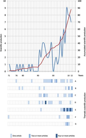
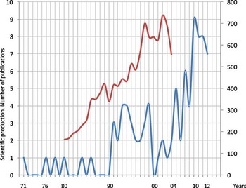
We analysed scientific outputs by SCI from 1971 to early 2012. Around 93% of the articles have been published in the last 22 years (1990–2012) (Fig. 1). The curve of scientific productivity showed a positive trend, similar to the trend for Antarctica publications as a whole for the period 1980–2004 (Dastidar Reference Dastidar2007) (Fig. 2).
Scientific paper publication over time resulting from research on Byers Peninsula (1971–2012). Blue line indicates the number of publications produced each year (left axis). Red line indicates the accumulated publications through time (right axis). A: Palaeontology, B: Geomorphology and Soils, C: Terrestrial Biodiversity, D: Geology and Stratigraphy, E: Limnology and Microbiology, F: Glaciology, Meteorology and Climate, and G: Human Dimension. Each bar represents a one year period. The number of publications per year is represented in three categories indicated by three colour intensities. This research incorporated only publications that appeared in Journal Citation Reports.

Comparison of the level of scientific paper publication over time resulting from research in Byers Peninsula and Antarctica as a whole. The red line shows the number of scientific paper produced each year concerning the whole of Antarctic science (Dastidar Reference Dastidar2007) (right axis). In comparison the blue line indicates the number of publications produced each year on science performed within Byers Peninsula (left axis).

The diversity of articles, classified by themes, was broad: Palaeontology (20%), Microbiology and Limnology (24%), Geology and Stratigraphy (19%), Terrestrial Biodiversity (15%), Geomorphology and Soil (10%), Human Dimension (5%) and Glaciology, Climate and Meteorology (7%).
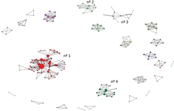
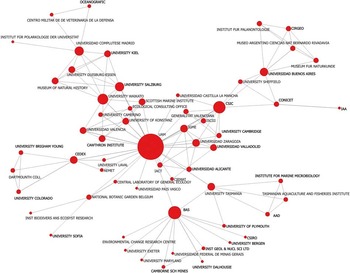
More than 200 authors have contributed to scientific research from Byers Peninsula (Fig. 3). In total 24 research groups were found with a minimum of two related authors and of these, 12 groups have five or more related authors. The rest are small independent research teams. In contrast, four aggregations contain nine or more related authors and three or more publications. These four clusters incorporate 44% of all authors and 54% of publications and are seen as big independent research consortia. In the main group, at the centre of Fig. 3, 58 authors are clustered. These authors belong to 110 institutions that have created a diffuse research network (Fig. 4). The node in the centre (Universidad Autónoma de Madrid, Spain) has the highest values for social connectivity (eigenvector) and has relationships with 45 of the 109 other institutions analysed (13 of which are Spanish).
Co-authorship social network. This figure attempts to show the level of interaction between researchers. Every node represents a single researcher, the size of the nodes indicates the number of publications by each author (degree). The lines show the relationships between the authors in the different publications (links).

Institutions participating in the publication of scientific research on Byers Peninsula. The eleven nations that engage in international collaborations are represented by researchers from 61 institutions. Each node represents the institutions participating in the publications. The size of the dots depends on the number of publications and the lines represent the co-authorship between different institutions.

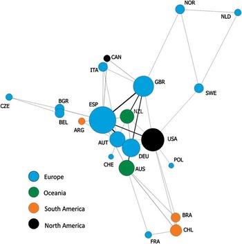
The 110 institutions belong to 22 nations, all of which are signatories to the Antarctic Treaty. Of these nations, 21 have joint publications with scientist from other nations (Fig. 5). The country with scientific publications but no international authorship is South Africa (Hall Reference Hall1994). More than half of the publications are from three countries: Spain (28%), United Kingdom (18%), and United States (9%). In this analysis, Spanish institutions have collaborated to the largest extent, with research links with institutes in eleven different countries (Argentina, Canada, Belgium, Bulgaria, Italy, Austria, New Zealand, Germany, United States, Australia and United Kingdom). A high level of international cooperation can be seen in Byers Peninsula research, with 66% of the articles co-authored by researchers from two or more institutions from two or more countries.
Nations producing scientific publications based on research within Byers Peninsula. Each node represents the nationality of the institutions producing the scientific papers. The size of the nodes indicates the number of articles per nationality and the lines, the nationalities of the institutions sharing authorship of the articles.

Discussion
Byers Peninsula research: a hotspot of scientific values
Research on Byers Peninsula is of great interest to scientist from a diverse range of scientific disciplines. Hathway & Lomas (Reference Hathway and Lomas1998) pointed out that the sedimentary and igneous outcrops constitute the best fossiliferous sequence for the Jurasic and Lower Cretaceous periods in the Pacific side of the Scotia Arc complex. These outcrops give highly valuable information for both geology and stratigraphy, and for the palaeontologic registry of marine molluscs and non-marine palaeobotany from these periods. Moreover, this area may have the most complete limnetic system in this region of the maritime Antarctic, with more than 60 lakes, freshwater pools and a dense network of temporary streams which are dependent upon seasonal snowmelt. The sediments within lake systems provide an essential archive for the study of the Holocene palaeoenvironment in the Antarctic Peninsula. From a biodiversity point of view, Byers Peninsula is considered a hotspot for Antarctica, with numerous species of different biological groups.
Research into all of these values has and will continue to require the presence within the ASPA of scientists from a wide range of scientific disciplines, including ornithology, entomology, botany, limnology, microbiology, geomorphology, geology and conservation biology. More recently, the development of increasingly sophisticated metagenomic techniques, which can now be incorporated readily into field research, has brought scientists from a new range of molecular biological disciplines into Byers Peninsula (e.g. López-Bueno et al. Reference López-Bueno, Tamames, Velázquez, Moya, Quesada and Alcami2009). Multi-disciplinary research often yields scientific insights of greater impact and value than science that focuses on only one discipline. Therefore, the presence of so many values of scientific interest within one area makes Byers Peninsula of immense value for research (Quesada et al. Reference Quesada, Camacho, Rochera and Velázquez2009), particularly as Antarctica continues to change. Furthermore, the long history of research in the area also makes it of potential value for the study of climate change impacts on terrestrial and lacustrine habitats and across a range of biological groups.
Nonetheless, the research lines conducted in Byers Peninsula have varied considerably since the original designation of the site as an SPA in 1966. Often the number of publications in certain disciplines are focussed around specific time periods (Fig. 1). This can be explained by the development of specific projects, for instance the production of publications concerning limnological studies has been mostly associated with the Limnopolar expeditions from 2001–10. On the other hand, periods of multidisciplinary scientific production in Byers Peninsula can be partially related to special events, such the International Expedition during the 1990–91 season. However, the rate of scientific production has been relatively consistent in the cases of palaeontology and, to a lesser degree, in geomorphology. It is also important to highlight the development of other areas such biological conservation in more recent years. Finally, when we compared levels of publication resulting from Byers Peninsula research with publications concerning Antarctica as a whole, we found a strong correlation (Fig. 2). The similar patterns may also reflect the participation in international events within Antarctica, such as the International Polar Year (IPY) during the 2008–09 season.
The social network analysis revealed the existence of different research groups in the scientific history of Byers Peninsula (Fig. 3). Up to 24 consortia were found to be present in the past or still active in research in the area with four dominant associations. When we examine the institutional network, we find a high level of relationship complexity (Fig. 4) involving institutes in 22 nations (Fig. 5). The proportion of Byers Peninsula publications co-written by contributors from different countries (66%) is much higher than that identified by Dastidar (Reference Dastidar2007) for all the scientific publications of Antarctica (34.42% in 2004). As shown by Bartneck & Hu (Reference Bartneck and Hu2010) higher levels of collaboration in multidisciplinary fields increased the scientific outputs associated with each investigation. This is especially relevant in Antarctica where every field activity, inevitably, has some environmental cost. Thus, it is crucial that all results obtained on Byers Peninsula be published to avoid repetition and reduce the possibility of unnecessary reiterative visits, since human presence will always represent an impact in this almost pristine region.
Environmental management of Byers Peninsula
The current Byers Peninsula ASPA management plan attempts to take into consideration the needs and interests of the numerous scientific disciplines working in the area, the overarching requirement to protect natural values of this site, and the requirements of each Party operating within the ASPA boundary. Specifically, the management plan aims to i) avoid degradation of, or substantial risk to, the values of the area by preventing unnecessary human disturbance, ii) allow scientific research on the terrestrial and lacustrine ecosystems, marine mammals, avifauna, coastal ecosystems and geology, iii) allow other scientific research within the area provided it is for compelling reasons which cannot be served elsewhere, iv) allow archaeological research and measures for artefact protection, while protecting historic artefacts present within this site from unnecessary destruction, disturbance, or removal, v) prevent or minimize the introduction to the area of alien plants, animals and microbes, vi) minimize the possibility of the introduction of pathogens which may cause disease in fauna within the ASPA, and vii) allow visits for management purposes in support of the aims of the management plan. A balance has been found that attempts to accommodate all of these aims, and the management plan details a range of conditions that must be met before permits should be granted for entry to the area. Many of the conditions (e.g. disposal of waste, sampling of materials, installation of equipment and structures) are common to other ASPA management plans. However, there have been some new initiatives that apply specifically to Byers Peninsula. In 2011, the management plan underwent a major revision and an international field camp was designated (62°34′35′′S, 61°13′07′′W), so that camping impacts are focused at one location, and two restricted zones were designated to protect the relatively pristine nature and scientific importance for microbiology of parts of the ASPA. In an attempt to preventing microbial or other contamination by human activity, those with permits to enter the restricted zones must wear sterile protective over-clothing, and to the maximum extent practicable, use only previously sterilized general field equipment and scientific equipment. In addition, camping and helicopter landings are not permitted.
ASPA No. 126 Byers Peninsula is unique within the Antarctic Protected Area System in being the only ASPA with three proponent Parties (out of the 71 ASPAs, 68 have a single proponent, and only two have two proponent Parties). To some degree, this may reflect international interest in the area and the willingness for Parties to engage in its protection. Nevertheless, better co-operation and communication between Parties and researchers is necessary for the continued protection of the values found within the area. Tourists are not permitted in the area, but inevitably long-term scientific research and environmental management activities have lead to some minor levels of impact, for example, by the creation of a path to an intensely studied lake, the presence of unmarked scientific apparatus of unknown origin and the presence of evidence of past field camps. Added to this, we still have no clear data on the level of introductions of non-native macro- and microbiota to the area, or information on the past use of stable or radioisotopes for scientific purposes. Both issues are generic across Antarctica.
Looking forward the overall protection of the area would be enhanced by: 1) more input into the environmental management of the ASPA by the various Parties who operate in the area, 2) better use of the existing Antarctic Treaty information exchange and reporting systems regarding the nature and location of activities undertaken in the area, 3) better on-going cooperation between Parties in the provision of logistical support for those working in the area, and 4) better interaction between scientists to prevent repetition of research that has already been undertaken. The high geodiversity and biodiversity and low levels of perturbation that characterize Byers Peninsula could in future lead to enhanced levels of research at this site. However, bearing in mind the need to protect and conserve the area, Antarctic Treaty Parties should only grant permits for scientific research within the Byers Peninsula ASPA ‘provided it is for compelling reasons which cannot be served elsewhere’, as specified in the area management plan. Furthermore, only studies whose impacts have been assessed as less than minor or transitory, should normally be permitted, as described in Annex I of the Protocol on Environmental Protection to the Antarctic Treaty.
Conclusions
The literature concerning Byers Peninsula, described in this paper, reflects the wide diversity of disciplines involved in research within this area over the past five decades. It is in the interests of all nations and scientists that Byers Peninsula is conserved to the maximum degree possible, in order that this research may continue. The Antarctic Treaty System specifically encourages international cooperation between nations. Collaborations promote both enhanced productivity and permit coordination of different scientific and logistical activities, thereby avoiding duplicating efforts and minimizing unintentional impacts resulting from the scientific research. This work aimed to integrate the interdisciplinary scientific knowledge about Byers Peninsula in order to facilitate both future international cooperation and enhance the cooperative conservation of Byers Peninsula.
Acknowledgements
This is a contribution of three projects: LIMNOPOLAR, EVA-ANTARCTICA and MIDAH. It was supported by the Spanish Government (REN2000-0435-ANT, REN2002-11617-E, CGL2004-20451-E, CGL2005/06549/02/01-ANT, POL2006-06635, CGL2007-28761-E/ANT, CTM2009-06604-E and CTM2010-11613-E). This article was published thanks to the financial support given by the Ministerio de Ciencia e Innovación (Spain) with the grant ref. CTM2011-12973-E. The paper also contributes to the British Antarctic Survey Polar Science for Planet Earth (PSPE) Environment Office Long Term Monitoring and Survey project. Finally, we thank two anonymous reviewers for their useful comments.
Supplemental material
A supplemental table will be found at http://dx.doi.org/10.1017/S0954102012001058