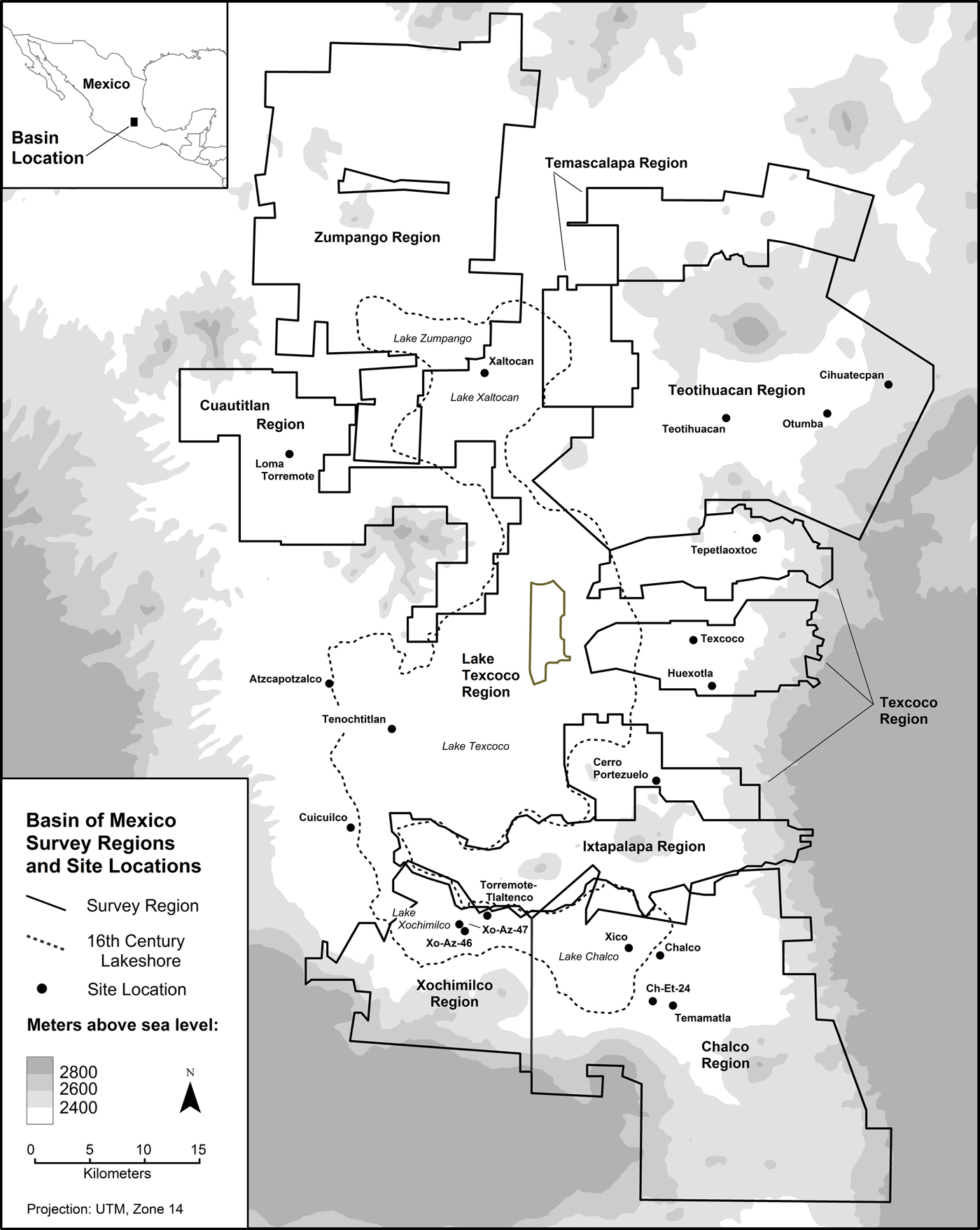
In this paper I examine the systematic regional surveys that were undertaken in the Basin of Mexico (BOM) between 1960 and 1975: how they were conceived, how they were carried out, what they accomplished, how they have served to guide subsequent research, and their implications for future archaeological investigation in this region. These surveys were conceived by William T. Sanders, and carried out over a dozen field seasons by Sanders, Richard Blanton, Mary Parsons, Thomas Charlton, myself, and our numerous field assistants (Figure 1). In part, this is an updating and extension of observations I made some 25 years ago that grew out of a summer seminar at the Instituto de Investigaciones Antropológicas at the Universidad Nacional Autónoma de México (UNAM) in 1987 (Parsons Reference Parsons1989).
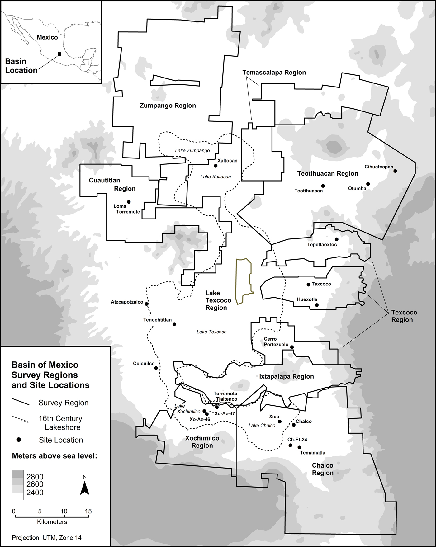
Basin of Mexico survey areas, and localities mentioned in text. Map by Larry J. Gorenflo.
BACKGROUND STUDIES—THE REGIONAL APPROACH, CHRONOLOGY, AND METHODOLOGY
Understanding the systematic surveys of the BOM in part requires knowing something about their conceptual and methodological foundations. Much of their conceptual underpinning lies in the pioneering Viru Valley, Peru, survey undertaken in 1946 (Willey Reference Willey1953). An earlier publication by Steward (Reference Steward1937) had stressed the importance of a regional approach in archaeology, and his ecologically oriented work in the United States Southwest inspired some of the Viru Valley research design at a time when most archaeologists were committed to site-specific investigations (Parsons Reference Parsons1972).
Although the Viru Valley survey was conceptually important for subsequent regional studies in the BOM, it did not provide a model for a methodology appropriate for systematic survey in non-desert environments where surficial archaeological remains are generally much more subtle than on the arid Peruvian coast, and where aerial photographs do not help much in site discovery. Such a methodology had to be worked out virtually from scratch.
By 1960, professional archaeologists had been working in the BOM for many decades. Their success in defining ceramic chronology helped make the systematic surveys realistic and effective right from the outset. Key studies (in roughly chronological order) include Gamio (Reference Gamio1920), Vaillant (Reference Vaillant1930, Reference Vaillant1931, Reference Vaillant1935, Reference Vaillant1938), Linné (Reference Linne1934, Reference Linne1942), Noguera (Reference Noguera1935, Reference Noguera1943), Armillas (Reference Armillas1944), Franco (Reference Franco1945), Griffin and Espejo (Reference Griffin and Espejo1947, Reference Griffin and Espejo1950), Tolstoy (Reference Tolstoy1958), Mayer-Oakes (Reference Mayer-Oakes1959), and Millon and Bennyhoff (Reference Millon and Bennyhoff1961). Although many chronological refinements still needed to be made, by 1960 there was an established and generally reliable ceramic chronology that could be used to date archaeological sites to major pre-Columbian periods on the basis of surface pottery. Another very important source of inspiration was Gamio's (Reference Gamio1922) study of regional and community organization in the Teotihuacan Valley. This innovative multidisciplinary work included contributions from archaeology, ethnohistory, history, ethnography, geography, and geology.
An additional, and perhaps more direct, influence on Sanders' thinking well before the outset of his investigations in the Teotihuacan Valley was Pedro Armillas' study of modern and prehistoric agricultural systems as components of an overall landscape (see, for example, Armillas Reference Armillas1949, Reference Armillas1971; West and Armillas Reference West and Armillas1950). Sanders had absorbed these ideas in the early 1950s while a student at the Escuela Nacional de Antropología e Historia (ENAH), where Armillas gave classes and accompanied students on fieldtrips. At about that same time, Eric Wolf and Angel Palerm applied some of Armillas' ideas to their pioneering regional study of pre-Columbian hydraulic works east of Texcoco (Wolf and Palerm Reference Wolf and Palerm1955). Armillas' emphasis on the archaeology of landscapes continued to guide our thinking throughout the regional surveys.
SCOPE AND METHODOLOGY
As the heartland of several successive major pre-Columbian urban civilizations, the Basin of Mexico has been an ideal natural laboratory for systematic regional archaeology directed at studying the development of preindustrial complex society. Survey archaeologists wanted to provide a regional perspective on major ancient urban centers in central Mexico, especially Teotihuacan, but also Tula, Tenochtitlan, Cuicuilco, and others. They wanted to be able to estimate population, to define administrative hierarchies, and to better understand land use, craft production, and exchange in their regional contexts, and they wanted to understand the ecological bases for cultural development (Palerm and Wolf Reference Palerm and Wolf1960; Sanders Reference Sanders and Willey1956, Reference Sanders1957, Reference Sanders1962, Reference Sanders and Meggers1968, Reference Sanders and Spooner1972).
In the 1960s and 1970s, surface conditions and the surficial archaeological record in the BOM were nearly ideal for effective regional surface survey—high visibility, with limited natural vegetation in a semi-arid and intensively cultivated landscape where frequent, but shallow plowing with animal-drawn implements annually produced a rich harvest of potsherds and other archaeological remains at the ground surface with minimal site destruction. Because many modern road building and construction projects were underway, new exposure of long buried archaeological artifacts and architecture were often available along ditches and road cuts.
A conference devoted to planning long-term archaeological research in the BOM (at the time, referred to as the Valley of Mexico) was held in 1960. The conference chairman, Eric R. Wolf, drew up a list of 13 specific research objectives to which interest should be directed (tabulated in Parsons Reference Parsons1971:1):
1. Changes in the natural and anthropogenic environments of the Valley of Mexico over time and the possible correlations of these changes with cultural factors,
2. The antiquity, development, and relative importance of major and minor patterns of land use over time,
3. The characteristics of settlement in the Valley of Mexico and changes in settlement patterns over time and related population problems,
4. The nature of relationships between hamlets, villages, towns, cities, and similar units at various periods including a discussion of relations between specific sites,
5. Problems of urbanization,
6. The characteristics of symbiotic regions in the Valley of Mexico in various periods of time and their social consequences,
7. The relevance of environment to agriculture and settlement patterns, and to the problems of social control at various levels,
8. Patterns of ceremonial control at various time levels,
9. Patterns of political control at various time levels,
10. Patterns of warfare in the pre-Columbian period,
11. Effects of the Spanish conquest and colonization on social and cultural groups in the Valley of Mexico,
12. Cultural persistence or change in major patterns throughout all known time periods within the Valley of Mexico,
13. Causal or functional relationships between various cultural patterns at different time periods.
It was with the above objectives in mind that Sanders and Millon initiated their complementary studies of the Teotihuacan Valley in 1960. Sanders (Reference Sanders1965) directed his attention toward the regional level, while Millon (Millon et al. Reference Millon, Drewett and Cowgill1973) focused on urban Teotihuacan.
Working out the Survey Methodology, 1960–1964
In the early 1960s, the systematic study of regional settlement patterns was still a radical new approach in archaeology. Sanders was one of the few doing it. He had the overall strategy clearly in mind, but the field tactics were still to be determined. I joined his project in 1961, precisely at the time when Sanders was developing these tactics, and I became involved in some of the early efforts to devise a survey methodology that would produce the data we sought.
As a newcomer to archaeology in 1961, I had no idea that I was intersecting with research that was radical and innovative. I had just graduated from Penn State with a Bachelor of Science degree in geology. In the summer of 1960, I had worked with one of my professors, Robert Scholten, on his geological mapping project in the Rocky Mountains of southwestern Montana and adjacent Idaho (Parsons Reference Parsons2002; Scholten and Ramspott Reference Scholten and Ramspott1968). Based on my experience in Montana and Idaho, regional mapping of surface features seemed natural and normal to me—walking systematically over the landscape, with aerial photos as guides and base maps, plotting out the distribution of surface features in order to develop ideas about long-term change. In 1960, it had been surficial geological features and ideas about geological dynamics in the northern Rockies; in 1961, and subsequently, it was surficial archaeological remains and long-term ancient cultural change in central Mexico. Once I had adjusted to looking for potsherds and mounds instead of rock formations and their weathered products, regional geological mapping and systematic regional archaeological survey seemed methodologically much the same to me.
By 1963 we had developed the essentials of an effective regional survey methodology. Much as a field geologist maps rock formations on the ground surface and infers the underlying structural forces that produced them on the basis of their spatial configuration, we archaeologists worked out procedures for walking systematically over the landscape, using aerial photos for guidance and for plotting the distributions of pre-Columbian surface pottery, the mounded remnants of architecture, canals, terraces, and other ancient features. We inferred relative chronology from the different pottery types we encountered where ancient houses and public buildings had once stood. Once the distributions of these material remains had been discerned and plotted on base maps, we could then proceed to develop hypotheses about long-term cultural change on the basis of changing regional settlement patterns.
Right from the start, we attempted to do what is now often called “full coverage” survey; it simply never even occurred to us to do anything else. This was, of course, some years before the concept of regional sampling began to be developed in archaeological research, and we were not part of that effort after it did begin to happen in the later 1960s (Parsons Reference Parsons1972, Reference Parsons, Fish and Kowalewski1990). I later consider some of the implications of how our notion of full coverage survey changed over time.
Extending the Surveys, 1967–1975
The Teotihuacan Valley regional surveys were completed in 1966. The highlights of this work appeared in preliminary form in Sanders (Reference Sanders1965), and the full details appeared in a series of monographs published intermittently over the following decades (Evans and Sanders Reference Evans and Sanders2000; Sanders Reference Sanders1987, Reference Sanders1996; Sanders et al. Reference Sanders, Kovar, Charlton and Diehl1970, Reference Sanders, West, Fletcher and Marino1975).
After 1966, the survey methodology developed in the Teotihaucan Valley was extended to other parts of the BOM—in 1967 to the Texcoco region (Parsons Reference Parsons1971), in 1969 to the Ixtapalapa Peninsula region (Blanton Reference Blanton1972), in 1969 and 1972 to the Chalco-Xochimilco region (Parsons et al. Reference Parsons, Brumfiel, Parsons and Wilson1982), in 1973 to the Zumpango region (Parsons Reference Parsons2008), and in 1974 and 1975 to the Cuauhtitlan and Temascalapa regions (Gorenflo and Sanders Reference Gorenflo and Sanders2007, Reference Gorenflo and Sanders2015; Sanders and Gorenflo Reference Sanders and Gorenflo2007) (Figure 1). During the later 1960s, Thomas Charlton (Reference Charlton1972) extended the original Teotihuacan Valley survey coverage farther to the northeast. In the early 1970s, Harold McBride (Reference McBride1974) completed a preliminary survey of the Cuauhtitlan region.
This sustained effort added many hundreds of square kilometers and several thousand archaeological sites to the regional settlement pattern database. I considered the significance of the University of Michigan surveys in a preliminary publication (Parsons Reference Parsons1974). Two more comprehensive general syntheses appeared a few years later (Sanders et al. Reference Sanders, Parsons and Santley1979; Wolf Reference Wolf1976). A compilation of the data generated by University of Michigan projects in the Texcoco, Ixtapalapa, Chalco-Xochimilco, and Zumpango regions was subsequently published in tabular format (Parsons et al. Reference Parsons, Kintigh and Gregg1983). A comparable compilation for the surveys carried out by Penn State University in the Teotihuacan, Cuauhtitlan, and Temascalapa regions has subsequently appeared (Gorenflo and Sanders Reference Gorenflo and Sanders2007).
A CRITIQUE
The surveys accomplished a great deal, but, at the same time, failed in some ways to realize their full potential. In this section I highlight my notion of these strengths and weaknesses.
Strengths
One of the main strengths of the surveys was in defining the “big picture.” Because the surveys were full coverage and systematic, they detected where sites were and where they were not over large, contiguous blocks of terrain. Because the remains of domestic architecture (house mounds) and surface pottery (and in many cases rock rubble) densities could be recorded with some accuracy over the ground surface, site areas could be defined and credible (albeit rough) population estimates could be made based on analogies with modern rural settlement densities. We could measure intersite distances and spatially relate specific sites to each other and to different kinds of environmental features. Because remnants of public architecture were usually detectable on the ground surface in the form of relatively high and large mounds, it was possible to make reasonable inferences about the relative sociopolitical importance of different sites based on the differential distribution of ceremonial-civic structures. Site hierarchies, using site area, artifact density, and volume of public architecture as proxies, could be generated and used to develop new hypotheses about sociopolitical organization.
Because the spatial relationships could be established between human occupation and different kinds of natural resources (agricultural, hydraulic, forest, lacustrine, and mineral), reasonable hypotheses could be developed about land and resource use. Because occupation gaps could be discerned, absences of settlement could be used to help develop ideas about natural and cultural factors that may have discouraged the establishment of permanent habitations in such areas. Because different periods of time could be compared on the basis of the same variables, it was possible to develop important new hypotheses about long-term changes in all of these parameters.
Another strength of the surveys was the generation of data useful to other scholars. Because the survey data were robust, they could provide the empirical foundation for subsequent studies by researchers who wanted to develop and evaluate hypotheses often completely unrelated to the objectives of the original surveyors. Examples of such studies include Alden (Reference Alden and Renfrew1979), Brumfiel (Reference Brumfiel and Flannery1976a), Earle (Reference Earle and Flannery1976), Gorenflo (Reference Gorenflo and Storey2006), Gorenflo and Gale (Reference Gorenflo and Gale1990), Parsons (Reference Parsons and Cleland1976), Smith (Reference Smith2002), and Steponaitis (Reference Steponaitis1981). Similarly, years later the original surveyors could reflect back on their old data in light of new ideas and information from the BOM and elsewhere (see, for example, Parsons Reference Parsons and Harvey1991, Reference Parsons2006; Parsons and Gorenflo Reference Parsons, Gorenflo and Cobean2016).
Yet another positive outcome of the surveys has been the use of curated collections in new research. These collections have provided the empirical bases for several important analytical studies over the past 40 years. Examples include studies by Mary Parsons (Reference Parsons, Spence, Parsons and Parsons1972a, Reference Parsons, Spence, Parsons and Parsons1972b, Reference Parsons1975, Reference Parsons and Williams2005), who examined the typological variability and spatial distributions of different kinds of figurines and spindle whorls; the typological, neutron activation, and spatial studies of Aztec ceramics undertaken by Mary Hodge and Leah Minc (Hodge and Minc Reference Hodge and Minc1991; Hodge et al. Reference Hodge, Neff, Blackman and Minc1993; Hodge and Neff Reference Hodge, Neff and Brumfiel2005; Minc Reference Minc1994, Reference Minc1999, Reference Minc2009; Minc et al. Reference Minc, Hodge, Blackman, Hodge and Smith1994); Christopher Garraty's (Reference Garraty2006) examination of the spatial variability of Aztec ceramics; Destiny Crider's (Reference Crider2011) study of the spatial variability of Epiclassic and Early Postclassic ceramics; and the efforts of Kenneth Hirth (Hirth et al. Reference Hirth, Luna and van Rossum2009) to compile large-scale geographic information databases of the original survey data that can eventually be widely shared and used by many scholars to develop and test new hypotheses in the future.
The survey data have also been important in the design and implementation of several subsequent field investigations in the BOM. These include Deborah Nichols’ (Reference Nichols1987) study of Formative agricultural intensification, and her subsequent investigations, in collaboration with Wesley Stoner and others, of the Formative-period Altica site in the eastern Teotihuacan Valley (Alex et al. Reference Alex, Nichols and Glascock2012; Stoner et al. Reference Stoner, Nichols, Alex and Crider2015); Paul Tolstoy's excavations and syntheses of Early and Middle Formative occupation in the southern BOM (Tolstoy and Fish Reference Tolstoy and Fish1975; Tolstoy et al. Reference Paul, Fish, Boksenbaum, Vaughn and Smith1977); Elizabeth Brumfiel's (Reference Brumfiel1976b, Reference Brumfiel and Issac1986) refined surficial study of the Aztec communities of Huexotla and Xico, and her subsequent investigations, as well as those of her students, at and around the Aztec center of Xaltocan in the northern BOM (Brumfiel Reference Brumfiel2005; Morehart Reference Morehart2012); Robert Santley's (Reference Santley1977) excavations at the Formative-period Loma Torremote site on the shore west of Lake Xaltocan; Parsons et al.'s (Reference Parsons, Parsons, Popper, Taft and Farrington1985) excavations of chinampa-related sites in Lake Chalco-Xochimilco; Susan Evans’ (Reference Evans1988) excavations of the Aztec community at Cihuatecpan; Mari Carmen Serra Puche's (Reference Puche and Carmen1988) excavations at the Formative-period Terremote-Tlaltenco site in Lake Xochimilco, and her subsequent excavations at the Formative-period Temamatla site on the southeastern shore of Lake Chalco (Serra Puche et al. Reference Puche, Carmen, Ramírez and González2000); María Castillo Mangas's (Reference Mangas and Teresa1994) and Carlos Lazcano Arce's (Reference Lazcano Arce1995) excavations (under the direction of Mari Carmen Serra Puche) of chinampa-related sites in western Lake Xochimilco; the Instituto Nacional de Antropología e História (INAH) excavations at the Xo-Az-46 and Xo-Az-47 chinampa sites in Lake Xochimilco (Ávila Lopez Reference Ávila Lopez1995, Reference Ávila Lopez2006; Corona Martínez Reference Corona Martínez1996; Javier Gonzalez Reference Javier González1996); Charles Frederick's geo-archaeological studies of landscape change and chinampa development in the southeastern BOM (Frederick Reference Frederick, Thurston and Fisher2007); studies at the Aztec center of Otumba carried out by Thomas Charlton, Deborah Nichols, and Cynthia Otis Charlton (Nichols and Charlton Reference Nichols and Charlton1996; Charlton et al. Reference Charlton, Nichols, Charlton, Sanders and Evans2000); Mary Hodge's studies of the Aztec center at Chalco (Hodge Reference Hodge2008); Greg Luna's (Reference Luna2014) study of ancient chinampa and settlement distribution in Lake Chalco-Xochimilco; Sarah Clayton's (Reference Clayton2013, Reference Clayton2014) on-going investigations at the Cerro Portezuelo site; and Nadia Vélez's (Reference Vélez2007) overview of rural Classic-period settlement. Ortman et al. (Reference Ortman, Cabaniss, Sturm and Bettencourt2014) have recently used the BOM survey data as a test case in their effort to characterize the urbanization process.
Another strength of the surveys has been the advancement of ethnographic analogy in BOM archaeological research. Until recently, the BOM was a region in which many kinds of traditional activities continued to be practiced. Many of the living people we saw every day in their homes, fields, workshops, and marketplaces were, of course, the biological and cultural descendants of the very prehistoric populations whose lifeways we sought to understand through archaeological research. Many of these activities have been historically documented since the sixteenth century (Gibson Reference Gibson1964), and twentieth century ethnographers have provided important insights, especially into agricultural production (Parsons and Parsons Reference Parsons and Parsons1990; Santamaria Reference Santamaria1912; Sanders Reference Sanders1957; Schilling Reference Schilling and Rabiela1983/Reference Vaillant1938; Rojas Rabiela Reference Rojas Rabiela1983; Rojas Rabiela and Sanders Reference Rojas Rabiela and Sanders1985; West and Armillas Reference West and Armillas1950), but also into other economic pursuits (Parsons Reference Parsons2001, Reference Parsons2006; Rojas Rabiela Reference Rojas Rabiela1985). The archival sources also included census data that made it possible to estimate population size at the time of initial European contact in the early sixteenth century, and thus to develop an independent check on archaeologically derived population estimates (Sanders et al. Reference Sanders, Parsons and Santley1979).
Although the full potential of ethnographic analogy has not yet been realized, ethnographic studies have assisted in the interpretation of archaeological survey data. A few examples include:
1. Modeling the productivity and energetics of different kinds of agriculture, including highly intensive (chinampas) and extensive (maguey) systems (Parsons Reference Parsons and Cleland1976, Reference Parsons, Staller and Carrasco2010; Parsons and Parsons Reference Parsons and Parsons1990; Sanders Reference Sanders and Spooner1972; Sheehy Reference Sheehy and Drooker2001).
2. Modeling the productivity and energetics of salt making and the harvesting of aquatic resources in and around the lakes and marshes of the central BOM (see, for example, DeLeon Reference DeLeón and Hirth2009; Parsons Reference Parsons2001, Reference Parsons2006).
3. Understanding the functions of smooth-edged trapezoidal scrapers, which we originally thought were hoes but which we subsequently learned were scrapers for extraction of ixtle fiber from maguey leaves (Parsons and Parsons Reference Parsons and Parsons1990).
4. Understanding the role of spindle whorl weights in the production of different qualities of cotton and maguey-fiber thread (Parsons and Parsons Reference Parsons and Parsons1990; Parsons Reference Parsons and Williams2005).
Weaknesses
Perhaps the greatest weakness of the regional surveys in the BOM was starting in the wrong place. The decision to begin systematic survey in the Teotihuacan Valley was made primarily because of Sanders' interest at that time in developing a regional context for urban Teotihuacan, and because of the obvious complementarity between Sanders' regional study and Millon's focus on urban Teotihuacan itself. In retrospect, however, we now realize that we should have initiated the basin-wide surveys in the opposite, southwestern corner of the BOM, in what we might then have called the Cuicuilco region. In 1960, this part of the BOM was still relatively uncovered by the urban sprawl that had overwhelmed it a few years later. By contrast, significant urban sprawl did not get underway in the Teotihuacan Valley, or in most other parts of the eastern BOM, until much later.
The Cuicuilco region definitely had survey potential in the early 1960s. In 1956, for example, Eric Wolf and Angel Palerm had located what appeared to be ancient canals that extended beneath the lava overlying the Cuicuilco archaeological site (Palerm et al. Reference Palerm, Palerm and Wolf1961; Wolf and Palerm Reference Wolf and Palerm1956). Inspired by Wolf and Palerm's study, in 1962 Charles Kolb and I attempted a weekend survey of the Cuicuilco site and its surroundings, working with aerial photos to locate areas that remained uncovered by the Xitle volcano lava flow (there were many such places, and some contained archaeological surface remains). We commuted laboriously back and forth from Teotihuacan on public transport for a few weekends until we gave it up because of the sheer logistical difficulties. A full-scale regional survey in the southwestern BOM in the early 1960s would certainly have produced a large amount of important regional information in an area that is now covered by dense modern settlement. Comparable efforts also could have been made at that time in the western BOM, beginning just north of what was then the northern edge of Mexico City in the vicinity of Tenayuca—another area that soon afterward disappeared under dense urban sprawl.
Another weakness was reliance on implicit bridging arguments. During the years when we were conducting the regional surveys, we assumed that if we simply surveyed a large enough area, a great deal of important new understanding would emerge. And so it did. We had definite expectations about what the survey data could tell us. These expectations, however, were largely implicit and often emerged inductively only after the survey data had accumulated. Even less explicit were the bridging concepts linking our data with the inferences we might draw from them. One example was our tendency to equate site with settlement and community mainly based on ethnographic analogies with early and mid-twentieth century settlement patterns in central Mexico (Parsons Reference Parsons1971; Sanders Reference Sanders, Eckholm and Bernal1971). This meshing of potentially non-equivalent analytical categories in certain kinds of spatial analysis—for example, rank-size or nearest-neighbor—might well produce misleading results. Greater familiarity with a wider range of historical and ethnographic literature might have enabled us to develop more sophisticated and more explicit models of expectations of what our data signify in sociocultural terms.
Another problem involved site definition. Because we were mainly interested in settlements, most of our concern was to define sites which we believed were the remains of ancient places of residence. This often seemed to be a fairly straightforward task, since many apparent settlement sites could be easily defined on the ground on the basis of well-bounded distributions of surface pottery, lithic remains, and remnants of domestic and/or public architecture. In many cases (especially for the Late Aztec occupation), we had to contend with highly diffuse distributions of low-density surface remains that often defied our attempts to classify them as settlements. We either tended to ignore such remains, or lumped them into sites of highly variable size whose borders were often wholly arbitrary. In later years, I came to realize that we had failed to make a proper distinction between site and off-site archaeology (as discussed below).
An important problem with the surveys was an overly narrow focus on chronology and ceramics. Early in the Teotihuacan Valley survey, we concluded (perhaps prematurely) that we could deal effectively with some issues (for example, population estimation, site size, occupational chronology, architectural complexity), but less well with others (for example, intrasite variability, site function, production, exchange, and cosmology). Consequently, we soon abandoned any systematic effort to collect surface data that might have provided an empirical basis for studying activity areas, social or economic variability, or ritual practices. Rather, we focused almost entirely on occupational chronology, and employed intuitive grab sampling of surface pottery as the best means to control this key variable. We also committed ourselves to defining the “big picture,” opting to maximize extensive areal coverage at the expense of more intensive surface collection and text excavations within sites.
Because we believed them to be chronologically undiagnostic, we paid little attention to lithic artifacts, thereby missing a great deal of potential insight into site function. It embarrasses me now, for example, to remember that I was once so dismissive of lithics that in 1964 I advised my keen-eyed field assistant, Warren Barbour, to forget about his prescient observation that there were two different kinds of obsidian artifacts—gray and green—at sites in the eastern Teotihuacan Valley, and to get on with the really important task at hand: looking for more diagnostic potsherds. Just a few years later, with the advent of instrumental neutron activation analysis in archaeology, this distinction between gray and green obsidian took on great significance. Warren was simply a little ahead of his time, while I remained a little behind mine.
We should probably have sacrificed some areal coverage in order to do a little more in-depth work at a few carefully selected sites, so as to refine chronology and illuminate site function and intrasite variability. Such a strategy could have provided a much better understanding of settlement systems, and perhaps with bases for devising new survey techniques in order to deal with emerging new questions. On the other hand, in retrospect our “big picture” focus was certainly appropriate in terms of the then unforeseen severe degradation of the regional archaeological record that lay only a few years ahead. Had we concentrated more fully on refining chronology and function, we might never have got very far out of the Teotihuacan Valley.
One of the best reasons for undertaking more in-depth work during the 1960s and 1970s is simply that so many of the sites which most warranted more intensive study were soon to disappear through intensification of modern land use in the form of mechanized agriculture, land leveling and deep plowing, reforestation and land reclamation (chisel plowing and massive terrace building), urban sprawl, trash dumping, etc. Due to our limited ability to specify function, our site typology, based as it is on only a few variables, remains imprecise and essentially untested. I suspect, for example, that many (most?) of the sites in our small hamlet category are not permanent settlements at all, but probably represent intermittently occupied localities where a much more narrow range of activities were carried out.
Obviously, beginning in the 1970s we should have initiated a series of follow-up archaeological and ethnographic field studies aimed at answering the kinds of questions I have just posed. This was a time, despite the beginnings of serious site and landscape degradation, when there were still a lot of intact sites and landscapes in the BOM. A few such studies were carried out at that time and later (for example, Ávila Lopez Reference Ávila Lopez1991, Reference Ávila Lopez1995, Reference Ávila Lopez2006; Brumfiel Reference Brumfiel1976b, Reference Brumfiel and Issac1986, Reference Brumfiel2005; Charlton et al. Reference Charlton, Nichols, Charlton, Sanders and Evans2000; García Chávez Reference García Chávez1991, Reference García Chávez2004; Hodge Reference Hodge2008; Nichols and Charlton Reference Nichols and Charlton1996; Will Reference Will1975), but why did we not do a lot more of this? A major factor was that the principal investigators in the BOM surveys (Sanders, Blanton, and Parsons) were attracted to other research areas at exactly this period: Sanders to the Maya region, Blanton to the Valley of Oaxaca, and Parsons to the Peruvian Andes.
Sanders returned to the BOM in the early 1980s for excavations at Tlajinga in the southern part of urban Teotihuacan (Storey Reference Storey1992). A decade later, he hoped to develop a new field project at Aztec Tepetlaoxtoc (Tx-Az-24) to complement the ethnohistorical research carried out there by Barbara Williams and Herbert Harvey (Reference Williams and Harvey1997). But, by that time the Tepetlaoxtoc archaeological site had been so degraded by chisel plowing and terracing for reforestation that it was no longer possible to undertake systematic research there (Sanders Reference Sanders1997).
I also returned to the BOM in the early 1980s for excavations in the chinampa area (Parsons et al. Reference Parsons, Parsons, Popper, Taft and Farrington1985), but soon thereafter was caught up for several years in administrative commitments at the University of Michigan, and found it impossible to direct any sustained archaeological field research during that period. I turned to ethnographic studies—less demanding in terms of time, scheduling, and funding—and got so interested in these investigations that I continued them into the early 1990s (Parsons Reference Parsons2001, Reference Parsons2006; Parsons and Parsons Reference Parsons and Parsons1990). By that time most of the archaeological sites that interested me had either been destroyed or radically altered by modern development.
A recurring difficulty with the BOM surveys involved ceramic chronology. Although the ceramic chronology available to us in the early 1960s has been considerably refined in subsequent decades, we were seldom able to refine our periods much below roughly 300 years—much too long to be able to detect key demographic and organizational changes that may have occurred over much shorter intervals. Thus, for example, our sites are palimpsests that might represent the cumulative occupation of up to 10 human generations, or more, with no way of determining the dynamics of settlement founding, expansion, or contraction within major periods. This chronological imprecision has almost certainly obscured some important intra-period changes.
A part of the chronological difficulty is because some of the existing refinements rely upon the presence of subtle variations in decoration and vessel form that are often obscured in the samples of fragmentary and badly weathered surface pottery present at most sites. Another problem is that some of the chronological refinements were made after we had evaluated the chronology of our surface collections. We could probably make significant improvements in our original chronological assessments by going back over the old collections—obviously a major task, but one that should eventually be undertaken.
Our surveys could have been considerably improved with greater geo-archaeological input. Our implicit assumption was that archaeological materials on the ground surface adequately reflected the extent and nature of the underlying subsurface remains. Although we occasionally questioned this assumption, it was never adequately tested, particularly within the area of deep soil at the juncture of the lower piedmont and the lakeshore plain where there is a major break-of-slope and where soil deposits are most likely to have covered archaeological remains. Our surveys have detected archaeological sites in such settings, some of them substantial, but without a fuller understanding of their geomorphological context, their significance sometimes remains unclear. Full-fledged geo-archaeological studies are the only way out of this conundrum. Although important beginnings have been made in studies by Frederick (Reference Frederick, Thurston and Fisher2007; Frederick et al. Reference Frederick, Winsborough, Popper and Brumfiel2005) and Córdova (Reference Cordova1997; Córdova and Parsons Reference Cordova and Parsons1997), these promising investigations represent only the first stage of what is needed.
Our survey methodology was incapable of dealing with aceramic remains in any meaningful way. Consequently, the regional surveys have made virtually no contribution to the definition of occupation during the millennia prior to about 1000 b.c., and we still have little idea of how or why preceramic hunter-gatherer populations became ceramic-using agriculturalists in the BOM. Despite some outstanding site-specific studies (see, for example, Niederberger Reference Niederberger1987), at the regional level we still understand very little about the nature of hunter-gatherer lifeways during any time period (both Archaic and post-Archaic). The Early and Middle Formative periods (1200–600 b.c.) in the BOM can never be fully understood until regionally oriented fieldwork can be directed at the underlying Archaic and Archaic-Formative transition (2000–1200 b.c.). Similarly, the economies of Formative and post-Formative periods will remain inadequately described until we are able to better discern (at the regional level) their non-agricultural components (hunters, fishers, collectors, salt makers, miners, foresters, etc.).
FUTURE NEEDS
Some needs in research on regional settlement in the BOM are so basic and obvious that they do not require much further elaboration beyond what I have already said: for example, chronological refinement, geo-archaeology, and the Archaic-Formative period transition. Other needs may be less obvious, and it is to these that I now turn.
The Potential of Off-Site Survey in the BOM
Even when we were concentrating on the notably high profile archaeological remains in our surveys, I was always conscious of the much more subtle material that we invariably encountered on the ground surface while walking between one site and another. Typically these diffuse remains were dispersed potsherds or isolated stone artifacts. We usually noted such finds when we saw them, but we made no special or systematic effort to discover or analyze them. Their presence was never included on any of our published maps, and we never incorporated them into our interpretations of regional settlement patterns.
Nevertheless, I have continued to wonder if these scattered artifacts could ever be useful for interpreting the regional settlement pattern data. In more recent years I have become aware that these remains are examples of what is often referred to as “off-site” material. In most cases, systematic regional study of such off-site remains (sometimes called “distributional archaeology”) had been most highly developed by archaeologists working in areas (such as parts of North America, Europe, southern Africa, Australia, or Inner Asia) where most archaeological remains are decidedly low profile relative to those in central Mexico (Ebert Reference Ebert1992; Foley Reference Foley1981; Honeychurch et al. Reference Honeychurch, Wright and Amartuvshin2007; Sampson Reference Sampson1988; Thomas Reference Thomas1983; Van Leusen and Attema Reference Van Leusen and Attema2002). The only archaeologist I am aware of who had systematically incorporated off-site remains into a regional study of state-level society in a region dominated by high profile archaeological remains is Henry Wright (Reference Wright1969), who recorded the distribution of scattered fired-clay sickles in order to infer the distribution of ancient cultivated fields dating to the Ubaid period (5500–4000 b.c.) in southern Mesopotamia. I was impressed by Wright's technique, but I never could figure out how I might do something similar in the BOM.
An important influence on my thinking about off-site archaeology has been recent research on preceramic settlement patterns in the Titicaca Basin, which straddles the border of Bolivia and Peru (Cipolla Reference Cipolla, Stanish, Cohen and Aldenderfer2005; Klink Reference Klink, Stanish, Cohen and Aldenderfer2005). This is the same general region where a number of full coverage regional surveys have been carried out (see, for example, Kolata Reference Kolata2003; Lemuz Aguirre Reference Lemuz Aguirre2001; Stanish et al. Reference Stanish, de la Vega, Steadman, Chávez, Frye, Onofre, Seddon and Chuquimia1997; Stanish et al. Reference Stanish, Cohen and Aldenderfer2005). All these latter surveys, however, were directed at the comparatively high profile post-Archaic remains that filled the landscape. As far as I knew, prior to Cipolla's and Klink's work in Titicaca, no one working in this same general area had ever paid much systematic attention, at the regional level, to the far more subtle remains of earlier hunter-gatherers. Years before, Lynch (Reference Lynch1970) had considered such an effort in the Peruvian north highlands, but had concluded that it would not be feasible.
I, too, had always assumed that it would be virtually impossible to do this kind of work in regions like the BOM where the archaeological traces of early hunter-gatherers had been so thoroughly overwhelmed by subsequent millennia of occupation by complex, agriculturally based societies. And yet, it is precisely this kind of information that is required in order to deal in new ways with the Archaic-to-Formative transition in the BOM and many other regions. Similarly, the work of Cipolla (Reference Cipolla, Stanish, Cohen and Aldenderfer2005) and Klink (Reference Klink, Stanish, Cohen and Aldenderfer2005) made me aware that much more might be learned about complex societies by applying the same discovery techniques to later periods that they pioneered for the more egalitarian societies who had occupied the same terrain at a much earlier time.
The 2003 Off-site Survey in Central Lake Texcoco
It was with these kinds of ideas in mind that I sought out new opportunities to see how other archaeologists were dealing with off-site remains. This search was what brought me to acquire new field experience in Australia (in 2000), Mongolia (in 2000), and Italy (in 2002). I learned a lot, some of which I adapted to my own new off-site survey in central ex-Lake Texcoco in 2003. We had simply ignored this latter area during our earlier surveys when we were interested in settlements—we defined ourselves as settlement-pattern archaeologists, and we ‘just knew’ there were no settlements out on the saline ponds and marshlands of Lake Texcoco.
Nevertheless, during the 1990s I began to change my mind about the survey potential of Lake Texcoco as I was conducting ethnographic studies of two rapidly vanishing traditional activities on and around the old lakebed: salt making and aquatic insect collecting (Parsons Reference Parsons2001, Reference Parsons2006). By chance, as I accompanied salt makers and insect collectors on their daily rounds over sections of the desiccated lakebed, I encountered many off-site remains: small concentrations of sherds and lithics, scatters of obsidian chips, and clusters of unworked rocks in an area many kilometers from any natural rock outcrops. I had seen a few such remains in earlier years, but I had then regarded them as peripheral and uninteresting. As I found out more about the central lakebed through my ethnographic and historical research, I also came to realize that it was a comparatively undisturbed landscape—no cultivation, little Holocene alluviation, and high surface visibility—an ideal field laboratory for systematic regional off-site survey (Cordova Reference Cordova1997).
In 2003, Luis Morett and I co-directed a systematic surface survey in central Lake Texcoco (designated as the Lake Texcoco region in Figure 1), using a much more intensive methodology than that of the earlier, and more extensive regional surveys. In two months our field team recorded more than 1,100 locations with archaeological materials in an area of approximately 20 km2. Some of these locations contained individual potsherds or stone artifacts, while others were diffuse concentrations of sherds and lithic debris measuring 5–50 m in diameter. Using our traditional survey methodology, we would have covered this same area in about two weeks, and we probably would have recorded no more than two or three small sites, that we would have classified as “camps”—an example of two radically different “full coverage” survey methods, with two radically different results. Preliminary analyses of the off-site data we recovered in 2003 have already revealed some distributional patterns suggestive of different kinds of specialized aquatic resource exploitation, formal territorial divisions within the aquatic landscape, and changing modes of occupation over time (Parsons and Morett Reference Parsons and Morett2004, Reference Parsons, Morett and Williams2005).
Our productive off-site survey on Lake Texcoco has made me think again about the meaning of the diffuse archaeological remains we dealt with so unsystematically in the course of our earlier surveys on higher ground in the BOM. It now seems to me that such remains, when located, recorded, and analyzed systematically, might provide useful new information about land use at the regional level—even where there has been overwhelming destruction and transformation of the archaeological record in recent decades. Sherds and lithics, after all, are virtually indestructible. If we look for them carefully and systematically enough, we may still find them not too far from where they were originally discarded (at least in areas not yet covered by modern constructions, deep alluvium, or bulldozed terraces prepared for reforestation projects). We might be especially successful in this effort if we could enlist the aid of geo-archaeologists to help us understand the geomorphological contexts of isolated artifacts and artifact scatters.
Such a systematic regional study of off-site remains might enable us to refine and elaborate older ideas about production. Sanders et al. (Reference Sanders, Parsons and Santley1979), for example, proposed that during the Classic period (a.d. 150–600) different elevation zones in the BOM were dedicated to the specialized production of specific agricultural, mineral, and forest products within a regional economy dominated by urban Teotihuacan. This important hypothesis remains untested. A well designed off-site survey aimed at detecting regional variability in the off-site distribution of tools and implements associated with specific tasks should help evaluate such ideas.
The Definition of High-Priority Sites for More Intensive Study in the BOM
The archaeological surveys of the BOM have identified hundreds of archaeological sites that warrant more intensive study. Ideally such study would include a lot of systematic surface collecting, numerous test excavations, and a smaller number of large-scale excavations. These sites would include a full range of types from large, nucleated settlements (our large villages and regional centers) to much more ephemeral occupations (our small hamlets). Because of wholesale site destruction, only a few of these sites are still sufficiently intact to make appropriate the traditional research strategies and tactics that we have practiced for decades.
There have been at least two earlier attempts to develop such a long-term research plan in the BOM:
1. In 1972, Pedro Armillas, William T. Sanders, and Kent Flannery collaborated in a seminar sponsored by INAH. One of the objectives was to develop a long-term archaeological research plan for the BOM (Manzanilla et al. Reference Manzanilla, Rabiela and Gussinger1973). I consulted on the compilation of sites that were considered to be deserving of special attention. Unfortunately, this research plan was never acted on.
2. In 1987 I conducted a field seminar at the Instituto de Investigaciones Antropológicas at UNAM. Like the 1972 effort, one of the objectives of this undertaking was to evaluate the condition of the BOM's archaeological resources and make recommendations for future research. The site evaluation was accomplished by a series of field trips to different parts of the surveyed region. On the basis of these fieldtrips I prepared a long-term regional research strategy that was published a few years later (Parsons Reference Parsons1989).
Neither of these two plans was ever implemented, and both are now obviously obsolete. A detailed new plan can only be developed on the basis of a new evaluation of archaeological resources within the BOM. With such an end in mind, in 2008 Larry Gorenflo initiated an on-going reexamination of archaeological sites throughout the entire basin. This effort will also seek to incorporate into a single database the aerial photo coverage of the entire BOM produced by the Companía Mexicana de Aerofoto for the 1930s through the 1980s.
Current Impressions about Site Survival and Future Research Potential
There are probably very few intact archaeological sites anywhere in the Ixtapalapa region, the Cuauhtitlan region, the Xochimilco region, the southwestern Texcoco region, most of Lake Chalco in the Chalco region, the southern Zumpango region, the western Teotihuacan Valley, and the western Temascalapa region. Urban sprawl has been a major destructive agent in these areas, but mechanized agriculture and land reclamation through the bulldozer-construction of huge terraces have also wrought havoc on archaeological sites and on the landscapes which contain them. Virtually all future field research in these regions will necessarily have to be based on salvage archaeology.
As previously noted, many surviving sites throughout the BOM have been seriously impacted by land leveling, terracing, and deep plowing. Although ceramic and lithic artifacts have probably survived in the same general vicinity as where they were originally deposited, the vertical and horizontal contexts of these materials have obviously been seriously disturbed. These remains might still be studied in the field, but they will demand some innovative new investigative and analytical techniques, including more thought about what kinds of questions such data might help answer.
A relatively higher proportion of known sites have survived more or less intact in the southeastern corner of the BOM. This area includes a large number of important Formative sites, plus significant numbers of post-Formative sites belonging to all major periods. The major Epiclassic site at Cerro Portezuelo, for example, is currently being studied by Clayton (Reference Clayton2013, Reference Clayton2014). Traditional research methods are likely to be most applicable in this part of the BOM.
Special attention should be given to non-protected sites, which, of course, means almost all sites other than parts of Teotihuacan, Huexotla, Cuicuilco, fragments of Aztec Tenochtitlan-Tlatelolco, and a very few others. I would even recommend a moratorium (voluntary or otherwise) on new field-based research at protected sites in order to concentrate scarce resources on vulnerable, unprotected sites that are not going to survive much longer on their own.
Because so many known surveyed sites have been destroyed, the surface collections taken from these sites during the 1960s and 1970s are necessarily going to become increasingly important, simply because nobody (except, perhaps, a few salvage archaeologists) will ever be able to carry out new field studies at these localities in the future. Most of these collections can never be replaced or replicated. The research potential of such collections has been convincingly demonstrated by their previously noted importance in compositional, stylistic, and distributional studies. Clearly, high priority must be given to curating these collections (including supporting field notes and photographs) in order to insure their continued survival and long-term integrity for future archaeological research (Parsons Reference Parsons1997).
Systematic Urban Surveys in Mexico City
Greater Mexico City is a vast urban sprawl that now covers much of the western half of the BOM, an area of perhaps 1,000 km2—the heartland of Aztec Tenochtitlan and other Late Postclassic (a.d. 1350–1520) centers, and of major earlier occupations extending all the way back to Early Formative (Tlatilco) and the antecedent Archaic period. Obviously, our regional surveys never dealt with the terrain covered by what was then already a burgeoning megapolis, and so our understanding of basin-wide settlement patterns remains incomplete. Is there any way to resolve this serious difficulty?
Despite the high density of modern urban occupation, I have personally seen many places throughout the city where surface archaeological remains are still visible and where subsurface artifacts have been exposed; for example, along ditches and road cuts, in vacant lots, and in several large cemeteries. These remains could be recorded on large-scale aerial photos, or other types of base maps, by groups of ENAH students working systematically under faculty supervision. Over time, such systematic recording could produce very useful information about pre-Columbian occupation within this huge area that now remains largely invisible archaeologically.
Such a project would be both effective and comparatively inexpensive, and would provide excellent training for students of archaeology. Some students might be intimately familiar with many local neighborhoods, thus facilitating the recording of archaeological remains in vacant lots, ditches, road cuts, construction sites, etc. If properly organized and managed over the long term, a systematic urban survey of this type could eventually help resolve such important problems as the extent of Classic and Epiclassic occupation in the Atzcapotzalco area, etc., for which only limited information is currently available (García Chávez Reference García Chávez1991, Reference García Chávez2004).
Archaeological Study of Pre-Columbian and Colonial Hydraulic Engineering
Armillas (Reference Armillas1971; West and Armillas Reference West and Armillas1950), and Wolf and Palerm (Reference Wolf and Palerm1955), long ago called attention to the capabilities of Aztec hydraulic engineers in regulating water levels within the chinampa district of the southern BOM. Archaeologists have addressed this topic in piecemeal fashion (see, for example, Ávila Lopez Reference Ávila Lopez1991, Reference Ávila Lopez1995, Reference Ávila Lopez2006; Blanton Reference Blanton1972; Parsons Reference Parsons1971; Parsons et al. Reference Parsons, Brumfiel, Parsons and Wilson1982, Reference Parsons, Parsons, Popper, Taft and Farrington1985). Most of our understanding of pre-Columbian hydraulic engineering, however, derives from studies of historical documents (Palerm Reference Palerm1973; Rojas Rabiela et al. Reference Rojas Rabiela, Strauss and Lameiras1974), and there is still little archaeological input into this important topic—one that must necessarily be addressed at the regional level. For example, how was large-scale drainage accomplished and how were water levels regulated over such a large area within an acceptably narrow range of variation over an annual cycle and from one year to the next; what is the time depth of such engineering capacity? Helen Pollard and colleagues have successfully addressed such problems through archaeological studies in the Lake Patzcuaro Basin (Fisher et al. Reference Fisher, Pollard and Frederick1999). Unfortunately, the primary study area for such archaeological research—the low-lying lakebed and lakeshore zones—is precisely that part of the BOM most impacted by modern development, and little remains that is sufficiently intact for new systematic surveys and excavations. There may still be enough left for useful study, however, obviously with a major geo-archaeological input. High priority should be given to such investigation.
Intensify the Archaeological Study of Lake Texcoco
The productivity of our off-site survey of central Lake Texcoco in 2003 indicates that the following regional studies should be carried out in the near future:
1. Extend the 2003 lakebed survey area eastward onto the still-unsurveyed terrain of the former lakebed and lakeshore. This should make it possible to determine whether the diffuse artifact scatters located in the 2003 survey extend shoreward, or whether there were larger, more enduring hamlets or villages closer to the former shoreline.
2. Undertake test excavations at several dozen key points identified in the 2003 survey as possible encampments on natural/artificial islands. These excavations should help clarify the nature of long-term alluvial or aeolian deposition (seasonal, inter-annual, and longer term), the impact of post-depositional flooding, and the possible existence of buried occupations of the Formative and Classic periods that may lie hidden below the modern ground surface of the former lakebed.
3. Undertake extensive excavations at six to eight representative sites identified as probable encampments in the 2003 survey, and at promising locations suggestive of more permanent occupation that might be discovered in new surveys farther east, in order to clarify occupational chronology, territoriality, the range of functions represented over time and space, and exchange relationships with agricultural settlements situated at higher elevations inland from the lakeshore.
4. Develop a detailed typology of lithic and ceramic artifacts in lakebed contexts. Subject these artifacts, especially the lithics, to detailed microscopic study in order to clarify use, function, and provenience. Such studies may help to define an aquatic toolkit.
5. Employ remote sensing technology to identify possible subsurface features in lakebed contexts. The absence of naturally derived stone in Lake Texcoco means that subsurface probes using magnetometer, resistivity, sonic, or ground-penetrating radar techniques should be particularly useful and productive, since virtually all stone will be cultural in origin. Such probes should be implemented widely over the former lakebed as a means of clarifying the subsurface nature of surface remains, and to discover buried occupation that may be invisible at the modern ground surface.
There is a distinct note of urgency for any future systematic archaeological study of Lake Texcoco. The only relatively undisturbed, non-urbanized area of the former lakebed/lakeshore lies in and immediately east of the 2003 survey area (Figure 1). Parts of this area lie within the federally protected region in which our 2003 survey was carried out. Most of this surviving zone of still-open terrain, however, is within the agricultural and grazing lands controlled by local communities and private owners, and all are subject to rapid and unpredictable development, either through urban sprawl or through the further mechanization of agriculture. Even the federally protected zone in central Lake Texcoco can easily be expropriated by higher-priority modern development, as the recent airport-expansion project that, until 2002, had been scheduled to be built atop that very zone aptly demonstrated. Although this airport project was abandoned amidst great controversy in 2002, an even more ambitious airport expansion project has recently been proposed anew in 2014 (see The Dirt 2014). There continues to be tremendous pressure to develop this landscape and its surroundings, and it probably will not endure for much longer in its present, and relatively pristine, condition.
SUMMARY
A new methodology for systematic regional survey emerged in the Teotihuacan Valley in the early 1960s, based in part on the author's previous exposure to systematic geological mapping in the Rocky Mountains. The archaeological surveys that followed in the Basin of Mexico used that method in each of the remaining survey regions, yielding information on the presence of thousands of pre-Columbian archaeological sites. The surveys were different in many ways from anything that preceded them in archaeology. Much of the information they generated became central to our understanding of long-term pre-Columbian cultural change in the BOM, but, like any new method, they also had certain shortcomings—weaknesses or problems that become clear in hindsight and after critical reflection.
The 1960–1975 regional surveys were highly effective in developing a general scenario for long-term cultural development in the BOM, and in providing the foundation for some important new field and laboratory research in subsequent decades. They were less successful in defining regional settlement systems where site functions, intrasite variability, intersite relationships, geomorphological contexts, and fine-grained chronology could be fully integrated to produce a more complete view of long-term cultural change.
The original surveys encountered the phenomenon of off-site archaeological remains, but were unable to deal with these diffuse artifact scatters in any meaningful way. A subsequent intensive “off-site” survey of central Lake Texcoco revealed how much “low profile” information exists, providing a glimpse of how useful such data can be in understanding prehistoric adaptation. Such data have potential promise for new research in the BOM, but developing new ways of dealing with these diffuse remains at the regional level will be challenging. New kinds of effective off-site research are likely to be the primary way that the long preceramic Archaic period can be dealt with at the regional level in areas where systematic survey is still possible.
Ethnographic studies of different forms of traditional agricultural and artisanal production have played an important role in interpreting the archaeological record in the BOM. It is important to undertake more such studies in central Mexico, and elsewhere in Mesoamerica and in other parts of the world, before the last traces of these deep-seated lifeways disappear in the face of world-wide modernization and globalization (Williams Reference Williams2003, Reference Williams2014).
Urban sprawl and the intensification of land use have seriously degraded the archaeological record throughout the BOM. The loss of numerous key sites has been devastating. Nevertheless, there are several important surviving sites, especially in those deep-soil zones, such as Ch-ET-24 at the southeast corner of Lake Chalco (Figure 1), where traditional field techniques can still be effectively applied. New research strategies and tactics will have to be developed to deal effectively with the degraded archaeological record. The Salvamento Division of INAH must play an increasingly central role in future archaeological research within the BOM, and especially high priority should be given to vulnerable, unprotected sites and localities. A long-term survey of open lots, ditch and road cuts, cemeteries, and construction exposures within the Mexico City megapolis should be made part of the ENAH curriculum in order to help gain more insight into the pre-Columbian occupation of the unsurveyed western BOM.
RESUMEN
A principios de los 1960 fue desarrollado el Valle de Teotihuacan una nueva metodología de sistemático reconocimiento arqueológico regional de la superficie, con influencia de la experiencia anterior del autor en el mapeo geológico. Esta misma metodología fue empleado hasta 1975 en los reconocimientos arqueológicos de la superficie en otras partes de la cuenca de México, produciendo nueva información sobre miles de sitios prehispánicos. Posteriormente mucha de esta información se volvió clave en comprender el desarrollo cultural prehispánico en la cuenca. Sin embargo, como cualquiera metodología nueva, la nuestra tuvo ciertas carencias que se aclararon retrospectivamente con reflexión crítica.
Los reconocimientos de 1960–1975 tenían éxito en crear un escenario general del desarrollo cultural de largo plazo, y en proveer una fundación para algunas importantes nuevas investigaciones en las décadas posteriores. Tenían menos éxito en definir sistemas de asentamiento en que podrían ser incorporados una cronología más fina, las funciones de sitios, las relaciones entre asentamientos y los contextos geomorfológicos para producir una visión más completa de los cambios culturales a través del tiempo.
Los reconocimientos originales de 1960–1975 no podrían tratar en una manera efectiva con los artefactos encontrados en concentraciones difusas sobre el superficie. En 2003 se llevó a cabo un reconocimiento muy intensivo de tipo “afuera de sitio” (off-site) en el lecho del antiguo Lago Texcoco. Esta investigación demonstró la gran cantidad disponible de esta tipo de información y su utilidad en la interpretación de la vida prehispánica. Ahora es óbvio que estos datos sutiles también tienen potencial para la investigación arqueológica en la cuenca, pero obviamente es desafiante saber como tratar con estos datos a nivel regional. Necesitamos nuevos metodos de investigación de tipo “afuera de sitios” para tratar a nivel regional con la larga época precerámica y la transición arcaico-formativo.
Estudios etnográficos de diferentes tipos de producción tradicional argrícola y artesanal han ayudado mucho en la interpretación arqueológica en la cuenca. Es muy importante llevar a cabo más estudios de este tipo en el México central y en otras partes del mundo antes de la desaparación completa de tradicionales modos de vida arraigadas frente a las fuerzas de la modernización y globalización.
Se han degrado mucho los recursos arqueológicos por todo la cuenca frente al crecimiento urbano descontrolado y la intensificación de utilización de tierra. La pérdida de muchos sitios arqueológicos ha sido triste y durísimo. Sin embargo, todavía existen sitios sobreviventes, especialmente en zonas de suelo profundo—como, por ejemplo, el sitio Ch-ET-24 en la esquina sureste del ex-Lago Chalco—donde todavía son aplicables las técnicas tradicionales de investigación arqueológica. Necesitan nuevas metodos y técnicas de investigación para tratar con los recursos arqueológicos cada vez más degrados. La división de Salvamento del INAH tendrá que desempeñar un papel muy importante en la arqueología del futuro en la cuenca, y deben tener una alta prioridad los sitios vulnerables y no-protegidos. Dentro de las zonas urbanas, reconocimientos sistemáticos en lugares expuestos por la construcción, en zanjas excavados, en cementerios grandes, etcétera, podrían producir valiosa información en los grandes zonas todavía no-reconocidos del oeste de la cuenca.