


INTRODUCTION
The production and exchange of commodities was a defining element of medieval small towns.Footnote 1 While technological processes and the typological development of the goods produced are well understood,Footnote 2 studies of the relationships between industry and urban landscapes remain sparse. Much historical enquiry has over-emphasised the role of craft guilds, framing perceptions of production as being formally organised and overstating specialisation, economic restriction and hierarchical organisation while overlooking the economic role of those beyond guild structures, particularly female artisans and wider family units.Footnote 3 Craft guilds are less of a feature of smaller towns than larger ones, although less specialised guilds and fraternities did form, in some cases having a role in urban governance.Footnote 4
Documentary sources such as Freemen’s rolls and tax lists illustrate the range of urban professions, facilitating comparative analysis. These typically state only the ‘profession’ of the household head, masking the diversity of household economies and overlooking the complexities of industrial production whereby it was essential for craftspeople to develop relationships with those undertaking complementary crafts.Footnote 5 Analysis of industrial clustering in London shows, for example, that iron smiths, the charcoal market and other metal trades such as armouring were co-located around Cheapside.Footnote 6 Other metalworkers located themselves close to markets; farriers worked near the gates, goldsmiths clustered where luxury goods were marketed. This co-location was one cause of the emergence of London’s guild structure. Complementarity was not the only reason that such clustering occurred. In London, industries such as fishmongering and butchery were clustered by virtue of regulation, while other industries, such as the victualling trades, benefitted from dispersal.Footnote 7
In Beverley (East Yorkshire), pottery and tile production took place at the periphery, close to the river along which these bulky products could be transported. Metalworking was centred on High Street, with ready access to markets, whereas fulling and tanning clustered around a watercourse.Footnote 8 Similar spatial clustering has been observed in fifteenth-century Antwerp (Belgium),Footnote 9 and after the Black Death greater socio-economic zoning is evident in Leicester and Coventry. Here, large-scale suburban industry developed, particularly tanning and cloth working (which require large working spaces), although metalworking continued to be located within the commercial core.Footnote 10
These analyses have focused on larger towns with plentiful archaeological and historical evidence both for the administration and the spatial organisation of production. Here, we present archaeological evidence from smaller towns, focusing on four areas: the undertaking of industry within the home, the specialisation of towns in particular industries, the relationship between institutions, urban development and industry, and the broader relationships between industry and urban landscapes.Footnote 11 Industry took place at scales ranging from small-scale domestic production undertaken alongside other activities to specialised concerns engaged in a single industry, potentially employing labourers or apprentices. Evidential challenges make assessing the scale of production difficult, but here we focus on activities plausibly undertaken to serve the market.
DEFINING THE DATASET AND METHODOLOGICAL ISSUES
We take a maximalist approach to defining small towns as places with a borough charter or recognised by Everitt as market towns in c 1600,Footnote 12 which are ranked outside of the top fifty towns based on population estimates derived from the fourteenth-century poll tax.Footnote 13 Although the relative position of towns in league tables of population changes across the period, as represented for example by Domesday records and those of the 1524–5 lay subsidies,Footnote 14 the later fourteenth-century rankings are most representative for our core period of interest.Footnote 15
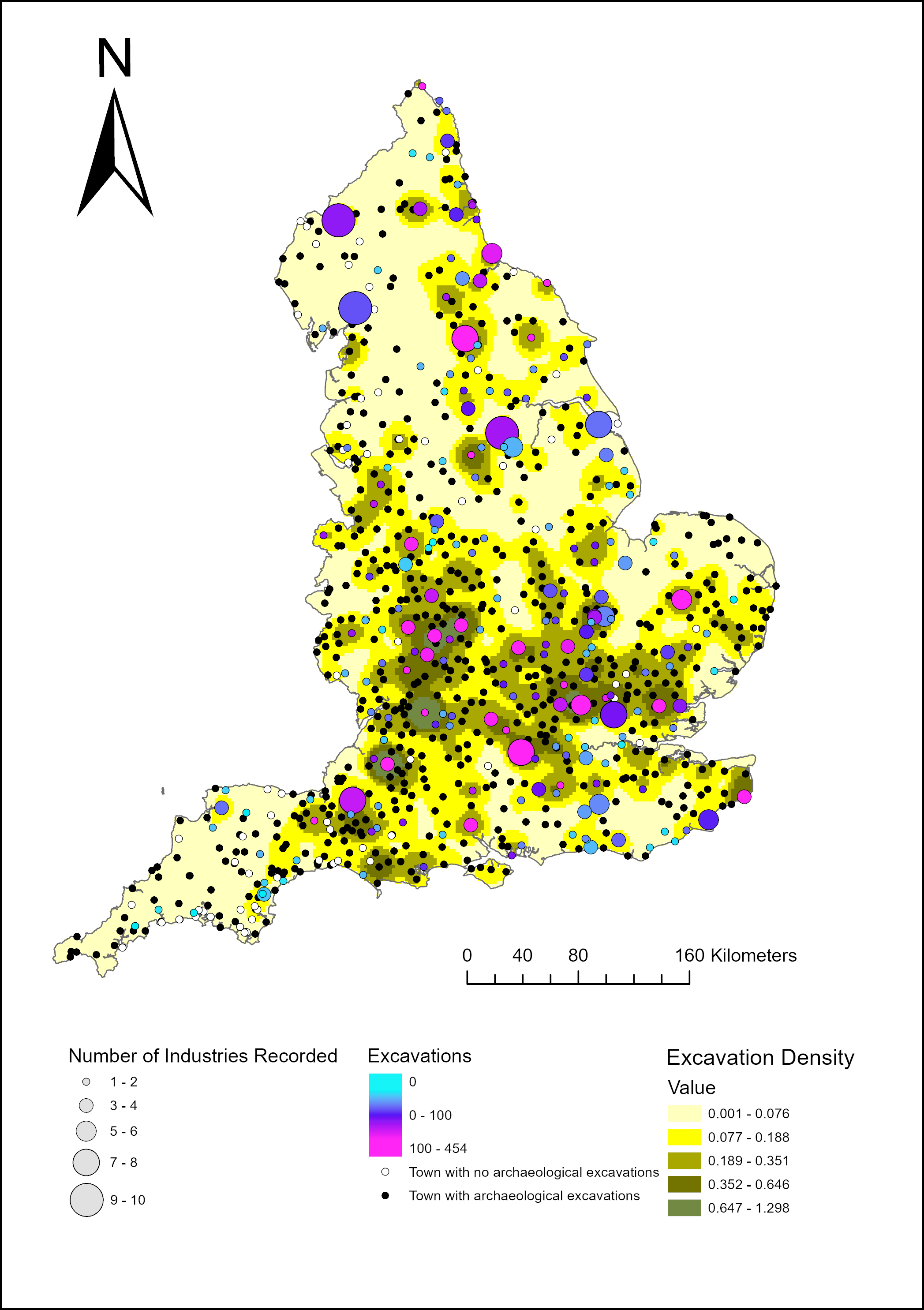
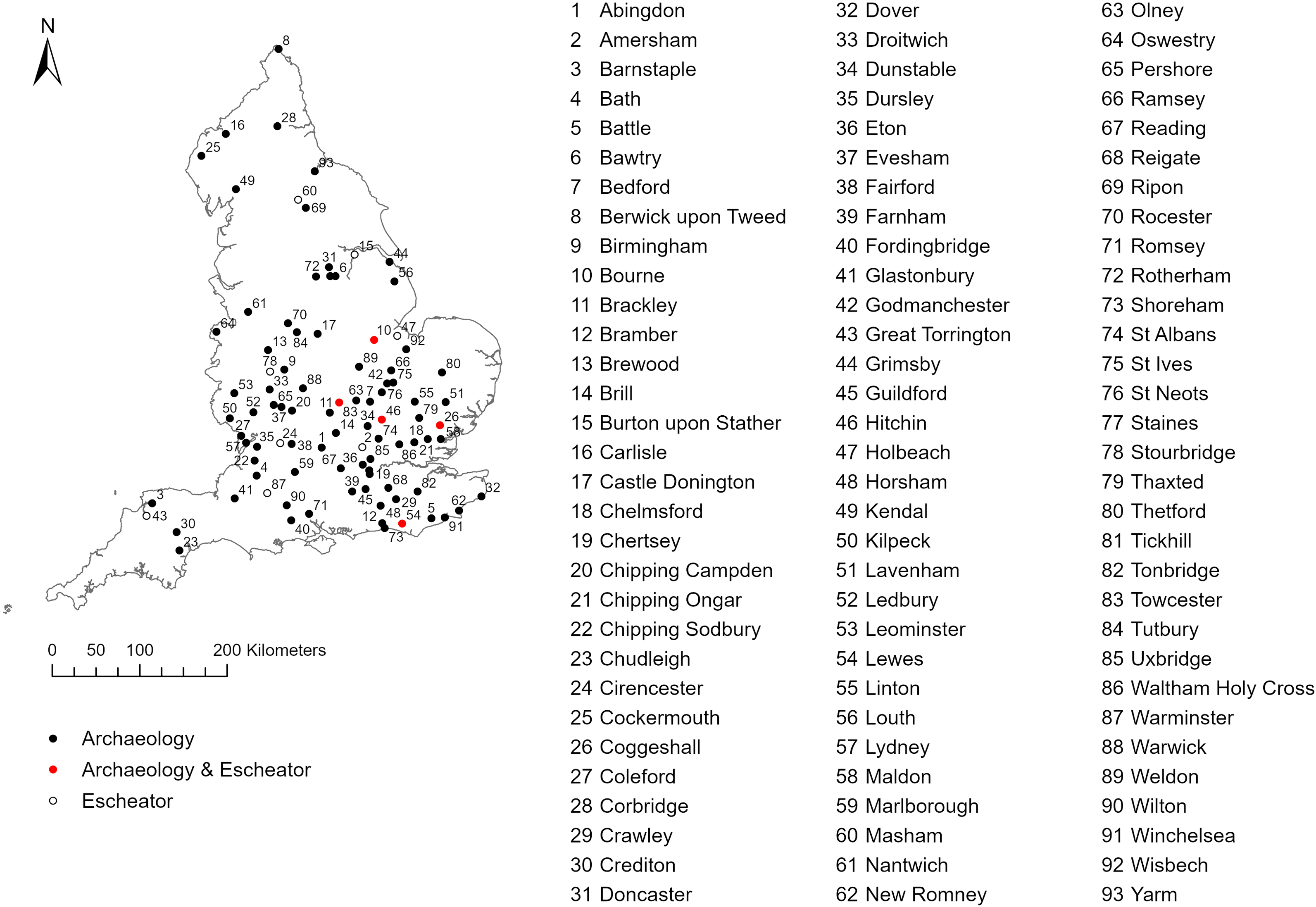
The volume of archaeological work undertaken in small towns, largely led by development, has increased substantially over the last thirty years.Footnote 16 Archaeological data are derived from a survey of published and unpublished excavation reports from 854 small towns in England, which identified 478 sites from 193 towns with evidence for production in the form of excavated features or material culture.Footnote 17 Even so, the dataset remains patchy. A lack of large-scale excavation limits understanding; for example, at Marlborough (Wiltshire) there were at least twenty-four individuals involved in the leather industry in 1377, including tanners, but archaeological investigations, limited to small-scale interventions, have not provided any evidence for this.Footnote 18 Fig 1 illustrates the distribution of evidence for craft activity relative to the intensity of archaeological excavation. This shows that generally the most diverse and abundant evidence for industry corresponds with areas of the most intensive excavation, with concentrations in Worcestershire, Somerset, southern-western Yorkshire and the London region. There are several regions with little or no evidence for industry. In the north-west and south-west, low quantities of work have limited the potential for evidence to be recovered, yet in the two most intensively excavated towns in the north-west, Kendal and Carlisle (both Cumbria), evidence for a diverse range of industries has been recovered. Evidence is also lacking in much of East Anglia and northern Essex, as well as in the Weald and areas of mid-Devon. In these areas, towns are, and remain today, generally very small. This has two implications: firstly, that it is probable that the economies of these places were less diverse than those of larger places and, secondly, that they are not subject to extensive development-led excavation. Additionally, cloth production, which leaves little archaeological trace, provided the economic basis of many of these regions. Furthermore, regional variation in practices of artefact reporting potentially affect our ability to infer industrial activities from archaeological reports.Footnote 19 For these evidential reasons it is not possible to present a regional analysis of archaeological evidence; instead, we focus on contextualising evidence within specific towns (see fig 3 for location of places referred to in the text).
Map showing the diversity of industrial evidence from towns relative to the quantity of excavation undertaken. The size of the points refers to the number of industries represented and the colour indicates the quantity of excavation (blues being low quantities and pinks being high quantities). The underlying heat map indicates the quantity of excavation at the regional scale. Image: authors.

Fig 1. Long description
The map displays the geographic region of England, highlighting the diversity of industrial evidence from towns relative to the quantity of excavation undertaken. The size of the points indicates the number of industries represented, with larger points signifying more industries. The color of the points ranges from blue to pink, where blue indicates low quantities of excavation and pink indicates high quantities. The underlying heat map shows the quantity of excavation at the regional scale, with darker yellow areas indicating higher excavation density. Key locations are marked with different sizes and colors of points, and the map includes a legend explaining the symbols and colors used.
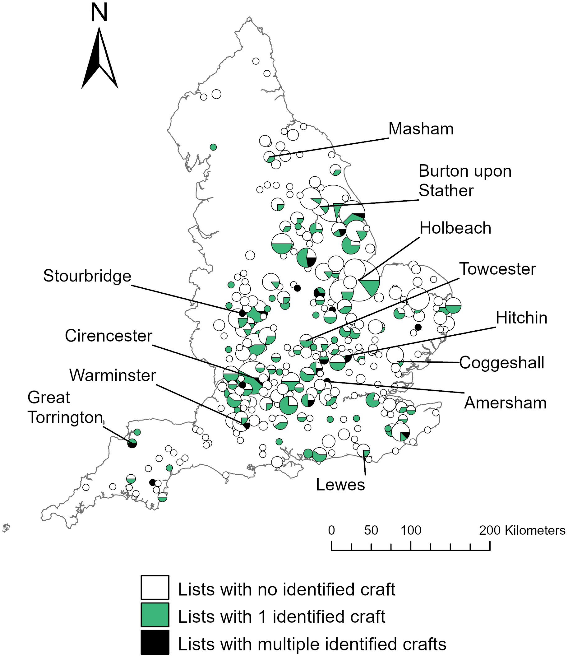
Map showing the distribution of Escheators’ lists. The size of the dot relates to the number of lists. The colouration relates to the number of lists from which no evidence of craft, one identified craft (green) and multiple identified crafts (black) were present. Places referred to in the text are labelled. Image: authors.

Map showing places referred to in the text. Image: authors.

Evidence for industry ranges from single finds of tools through to dumps of waste material and in situ structures. Here we primarily focus on those examples where evidence can be most confidently attributed to production on site or in the immediate vicinity. Materials such as kiln waste or slag could be re-purposed as hardcore, and single finds may be residual or intrusive within archaeological contexts. We primarily infer sites associated with industries such as ceramic production and iron working through the quantity of waste as well as the presence of kiln or furnace structures, and tanning through the presence of tanning pits, sometimes identified as such through their occurrence with faunal material characteristic of hide processing. Other activities, such as spinning, leave more ephemeral evidence in the form of single artefacts and, in discussing these, we place greatest weight on those recovered from primary contexts, such as floor surfaces, rather than secondary or tertiary deposits, such as pits or middens.
Even in well investigated towns, the character of excavation can limit the recovery of industrial evidence. At Guildford (Surrey), for example, no clear evidence of industrial production has been observed beyond the excavation of quarries, a deposit of horn cores and slag fragments. Two reasons can be proposed for this: firstly, that cloth production, likely Guildford’s dominant industry, leaves no clear archaeological trace and, secondly, that several excavations have focused on the street frontage, away from the areas that industrial structures might typically be located. A similar situation is evident at Maldon (Essex), where multiple excavations along High Street have provided excellent structural sequences but little evidence for industrial activity.Footnote 20
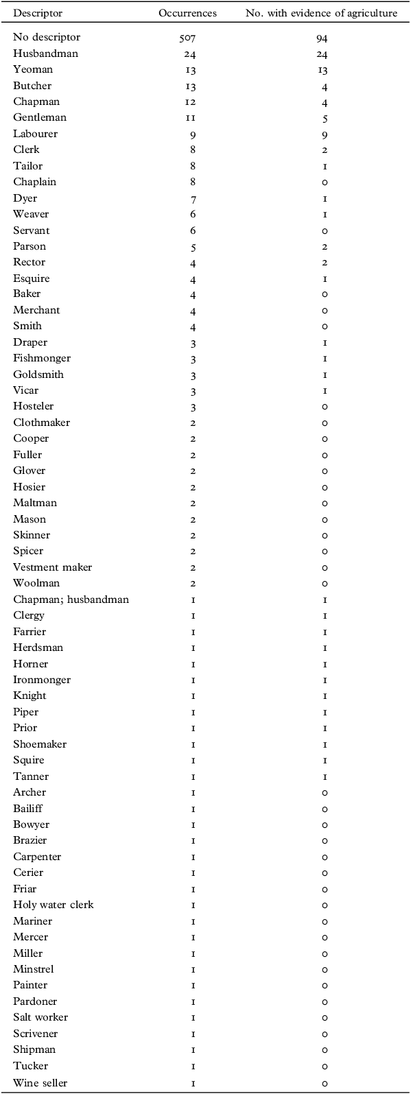
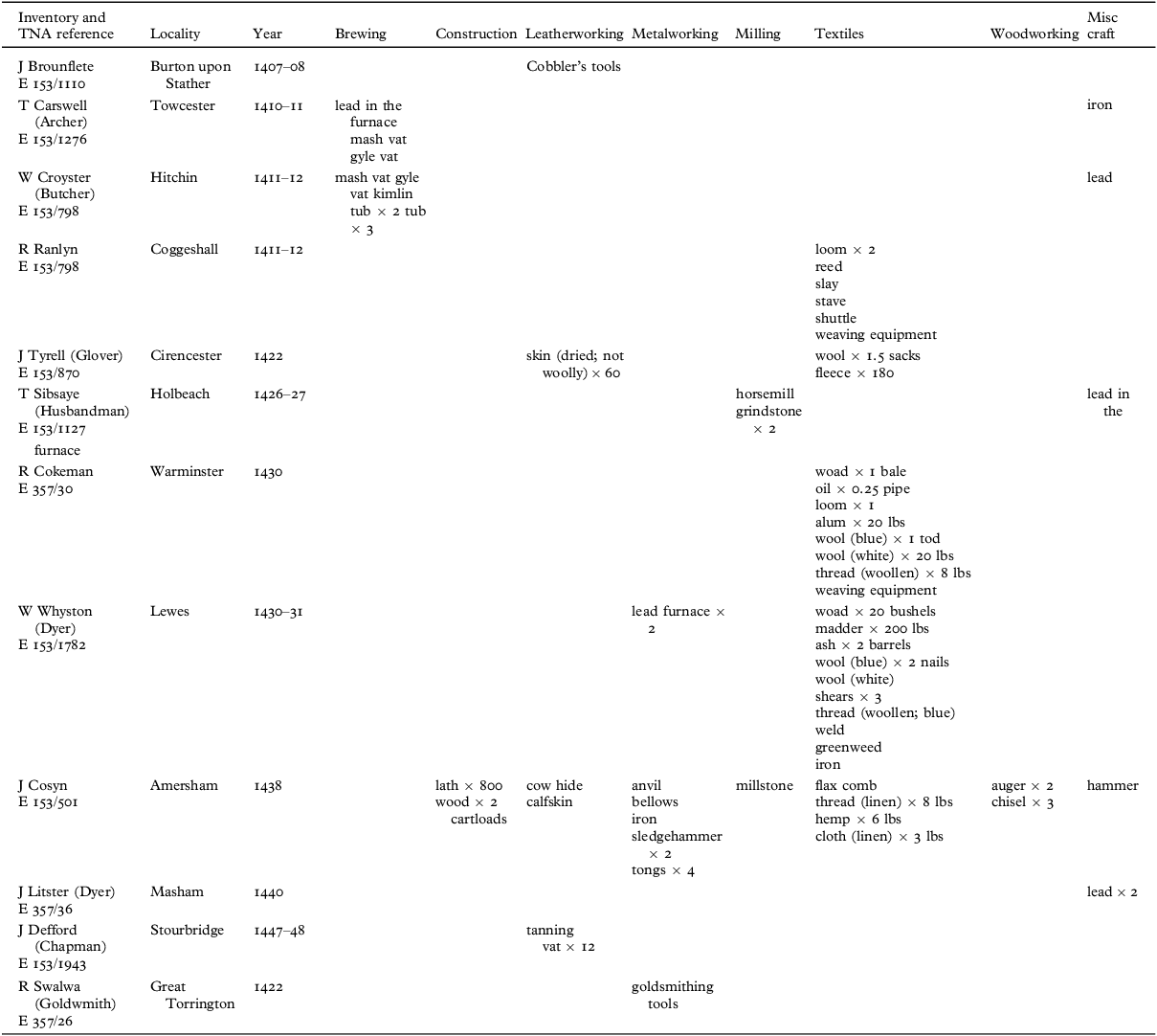
To further discussions of household-scale production, we introduce new historical evidence: later fourteenth–fifteenth-century lists of goods seized by the Crown from felons, which occur in the official records of the Escheator.Footnote 21 These documents are valuable because they pre-date the widespread production of wills and probate inventories, offering a unique insight into the possessions of lower status and middling households. The entirety of the Escheators’ files of inquests (E153) were examined for lists from small towns, yielding inventories for 725 different felons. Of these, 113 include items associated with a non-agricultural craft and 151 refer to an individual using a non-agricultural occupational descriptor. Overall, the non-agricultural occupation, or occupations, of a household could be deduced for 218 examples (tab 1), with sixteen having evidence for engagement in multiple occupations. Of these, seven illustrate the combination of a named craft and objects suggestive of engagement in multiple occupations, highlighting the issue of assessing occupational diversity purely based on singular occupational descriptors. Tab 2 summarises those referred to in the text. As with the archaeological evidence, regional comparison using these documents is challenging; the majority of lists are from the east midlands and the south, likely reflecting patterns in the right to cease the goods of felons that are not well understood (fig 2).Footnote 22 Furthermore, due to these lists omitting a range of low-value goods and the fact that some objects could be used for multiple processes, occupational diversity is understated.Footnote 23
List of occupations stated within the Escheators’ records and the number of individuals with evidence for involvement in agriculture (ie. ownership of animals, crops or agricultural equipment).

Table 1. Long description
A table summarizing occupations stated within the Escheators’ records and the number of individuals with evidence for involvement in agriculture. The table has 2 columns and 66 rows. Column headers are Descriptor and Occurrences. Row labels include No descriptor, Husbandman, Yeoman, Butcher, Chapman, Gentleman, Labourer, Clerk, Tailor, Chaplain, Dyer, Weaver, Servant, Parson, Rector, Esquire, Baker, Merchant, Smith, Draper, Fishmonger, Goldsmith, Vicar, Hosteler, Clothmaker, Cooper, Fuller, Glover, Hosier, Maltman, Mason, Skinner, Spicer, Vestment maker, Woolman, Chapman; husbandman, Clergy, Farrier, Herdsman, Horner, Ironmonger, Knight, Piper, Prior, Shoemaker, Squire, Tanner, Archer, Bailiff, Bowyer, Brazier, Carpenter, Cerier, Friar, Holy water clerk, Mariner, Mercer, Miller, Minstrel, Painter, Pardoner, Salt worker, Scrivener, Shipman, Tucker, Wine seller. Each row lists the descriptor, occurrences, and number with evidence of agriculture.
Summary of evidence for households engaged in occupations beyond their stated occupational identifier among the Escheators’ records.

Table 2. Long description
A table detailing households engaged in occupations beyond their stated occupational identifier among the Escheators’ records. The table has 13 rows and 11 columns. Column headers are Inventory and TNA reference, Locality, Year, Brewing, Construction, Leatherworking, Metalworking, Milling, Textiles, Woodworking, Misc craft. Row 1: J Brounflete, Burton upon Stather, 1407-08, Cobblers tools. Row 2: T Carswell (Archer), Towcester, 1410-11, lead in the furnace, mash vat, gyle vat, iron. Row 3: W Croyster (Butcher), Hitchin, 1411-12, mash vat gyle, vat kimlin, tub x 2, tub x 3, lead. Row 4: R Ranlyn, Coggeshall, 1411-12, loom x 2, reed, slay, stave, shuttle, weaving equipment. Row 5: J Tyrell (Glover), Cirencester, 1422, skin (dried; not woolly) x 60, wool x 1.5 sacks, fleece x 180. Row 6: T Sibsay (Husbandman), Holbeach, 1426-27, horsemill, grindstone x 2, lead in the furnace. Row 7: R Cokeman, Warminster, 1430, woad x 1 bale, oil x 0.25 pipe, loom x 1, alum x 20 lbs, wool (blue) x 1 tod, wool (white) x 20 lbs, thread (woollen) x 8 lbs, weaving equipment. Row 8: W Whyston (Dyer), Lewes, 1430-31, lead furnace x 2, woad x 20 bushels, madder x 200 lbs, ash x 2 barrels, wool (blue) x 2 nails, wool (white), shears x 3, thread (woollen; blue), weld, greenweed, iron. Row 9: J Cosyn, Amersham, 1438, lath x 800, wood x 2 cartloads, cow hide, calfskin, anvil, bellows, iron, sledgehammer x 2, tongs x 4, millstone, flax comb, thread (linen) x 8 lbs, hemp x 6 lbs, cloth (linen) x 3 lbs, auger x 2, chisel x 3, hammer. Row 10: J Listler (Dyer), Masham, 1440, lead x 2. Row 11: J Defford (Chapman), Stourbridge, 1447-48, tanning, vat x 12. Row 12: R Swalwa (Goldsmith), Great Torrington, 1422, goldsmithing tools.
WORKING AT HOME
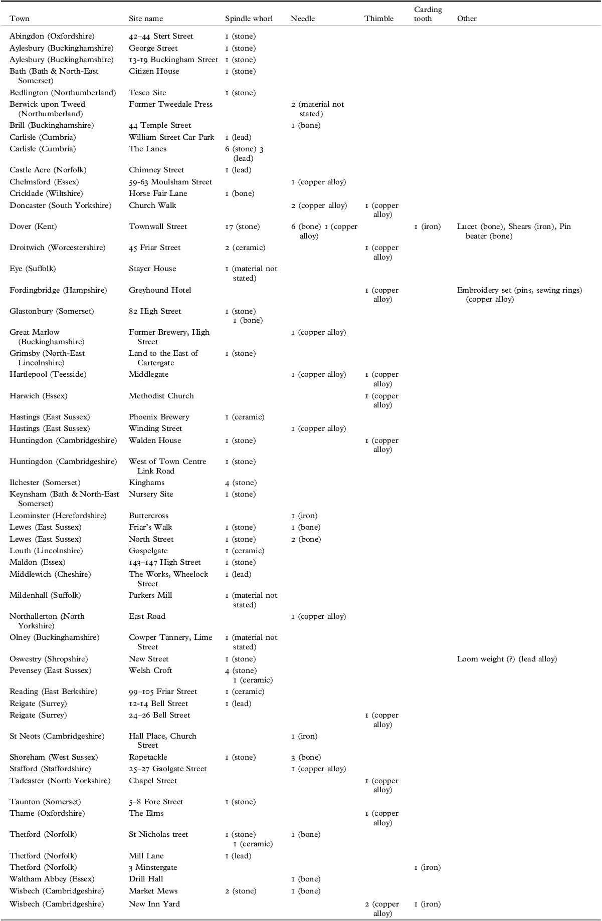
The interconnectedness of ‘domestic’ and ‘industrial’ spaces in towns is well attested. Discussing York, Goldberg considers spaces such as workshops and brewhouses as integral parts of the home.Footnote 24 However, not all townhouses had spaces for specialised artisanal activities and not everyone worked and lived in the same space.Footnote 25 Analyses of the economic role of women has particularly emphasised the home as a place of work.Footnote 26 Archaeological evidence such as spindle whorls and needles for textile production and working, the dominant industry in later medieval England, is extremely rare (tab 3); however, evidence is more abundant in the Escheators’ records. Spinning wheels are a relatively common occurrence, as are cards used for separating fibres (tab 2). While spinning could be undertaken to meet a domestic need, in many cases carding and spinning were likely undertaken to serve the cloth trade. By the sixteenth century, spinning was undertaken as waged work.Footnote 27 Textile working tools have been recovered from two possible inn sites: a spindle whorl from Swinegate, Louth (Lincolnshire),Footnote 28 and a needlework set from the Greyhound, Fordingbridge (Hampshire), a documented sixteenth-century inn.Footnote 29 There is a particular association between spindle whorls and coastal and riverine sites associated with fishing, suggesting that they were used to manufacture and repair nets.
Summary of textile working equipment from archaeological excavations in small towns (see supplementary materials for expanded version).

Table 3. Long description
The table lists textile working equipment found in various towns, detailing the types of equipment such as spindle whorls, needles, thimbles, carding teeth, and other items. It includes columns for town, site name, and the types of equipment found. The table has 48 rows and 6 columns. Each row provides specific details about the location and type of textile working equipment discovered. Notable towns include Abingdon, Aylesbury, Bath, Bedlington, and Bervick upon Tweed, among others. The equipment materials vary, including stone, bone, copper alloy, lead, ceramic, iron, and other unspecified materials.
Seventeen stone spindle whorls were excavated from a complex sequence of forty-one twelfth–fourteenth-century houses at Townwall Street, Dover (Kent), primarily from house floors.Footnote 30 Further evidence for fibre processing here includes two probable heckle comb teeth, a pair of shears, a ‘pin-beater’, perhaps for use in the manufacture of sacking, two bone ‘lucets’ (used for braiding) and a large copper alloy needle.Footnote 31 A large quantity of fishing equipment and fish processing waste show that fishing was the primary occupation here. Several other crafts are represented, including the small-scale working of antler, whale bone, iron and amber.Footnote 32 Grain processing is evidenced by quern fragments, mostly from a single building that also contained ovens likely used for baking and malting, suggestive of some household specialisation, the depositional context suggesting a clear link between these activities and domestic spaces.
Comparable evidence comes from two adjacent plots at Cartergate, Grimsby (Lincolnshire), where several industries are represented in twelfth–fourteenth-century deposits.Footnote 33 The northernmost plot yielded abundant evidence for fish processing, associated with a small structure containing two hearths. Environmental evidence indicates the stalling of animals and small-scale cultivation. A spindle whorl was recovered from a dump of domestic waste and several pits contained cobbling and leather working waste, implying a diverse household economy, perhaps due to the seasonality of the fishing industry, although it should be noted these activities may not be contemporary. The adjacent plot is characterised by a background spread of iron smithing waste, with a trough or tank perhaps used for quenching. A whetstone with heavy wear from sharpening blades was also recovered, a fragment of millstone grit perhaps functioned as a grinding stone and a deposit of fired clay may derive from an oven or furnace.
The Escheators’ records provide more conclusive evidence for diverse household economies, as they capture a single moment in time. Generally, lists suggest that those involved in specialised craft processes such as weaving or smithing did not possess large numbers of animals or engage in extensive arable husbandry (tab 1). In 1422, the goldsmith Richard Swalwa of Great Torrington (Devon) had a cow, calf and heifer as well as a ploughshare.Footnote 34 Most striking is John Cosyn of Amersham (Buckinghamshire) in 1438, who had an anvil and bellows for iron working, a cow hide, quantities of oats and barley, a flax comb and several woodworking tools (possibly products of his workshop) as well as eight piglets.Footnote 35 In 1447/8 John Defford, a chapman (trader) of Stourbridge (Worcestershire) had twelve tanning vats, suggesting he tanned hides alongside his commercial interests.Footnote 36
Despite the limited agricultural interests of specialist artisans, agriculture was an important part of small-town life. We analyse the evidence for agrarian activities elsewhere, concluding that, as a minimum, twenty-five per cent of households within the sample were involved in some form of agricultural production, with a further thirteen per cent owning small numbers of animals, numbers that undoubtedly understate the importance of agrarian production. This picture is corroborated by archaeological evidence such as cultivation soils and barn structures in towns such as Cockermouth (Cumbria) and Olney (Buckinghamshire) and remains of juvenile animals in towns such as Grimsby and Carlisle.Footnote 37
Agriculture’s importance is emphasised by the occurrence of ovens, used for crop drying, baking and malting, as the most common structural evidence for industry within plots.Footnote 38 At Chequer Street, St Albans (Hertfordshire), a series of fifteenth–sixteenth-century malting ovens were present.Footnote 39 Earlier evidence comes from Reigate (Surrey), where a twelfth-century kiln, dating to the earliest phase of the town, was present at 24–6 Bell Street within a three-sided structure, possibly a barn.Footnote 40 A similar, later thirteenth-century, structure was present at 16 Bell Street and a further possible kiln was identified at 43 High Street.Footnote 41 Brewing equipment occurs frequently in the Escheators’ lists, primarily in the form of ‘leads’ – large vessels used for boiling. Such equipment occurs in a range of households; for example, those of the dyer John Litster of Masham (Yorkshire),Footnote 42 the butcher William Croyster of Hitchin (Hertfordshire) and the archer Thomas Carswell of Towcester (Northamptonshire).Footnote 43 In some towns, such as Warwick (Warwickshire), drying ovens occur both within plots, as at Brook Street (possibly dating to the thirteenth–fourteenth centuries) and Swan Street,Footnote 44 as well as in more peripheral areas at the New Priory Medical Centre and Bread and Meat Close.Footnote 45 Evidence for drying and malting also occurs among archaeobotanical assemblages. For example, at Linton (Cambridgeshire) a chaff-rich assemblage of charred oat grains indicates that a thirteenth–fourteenth-century outbuilding was likely used for crop processing,Footnote 46 and a substantial assemblage of probable malting waste was recovered at the Castle Garage, Tutbury (Staffordshire).Footnote 47
Probable bread ovens have been identified at Park Lane, Towcester (fourteenth–fifteenth centuries),Footnote 48 25 High Street Pershore (Worcestershire; thirteenth–fourteenth centuries),Footnote 49 and Joy Street, Barnstaple (Devon; probably fourteenth–fifteenth century).Footnote 50 If such ovens functioned commercially, they reflect the ability of households to operate as small-scale commercial enterprises, with burgesses free from obligations to use manorial bakehouses.Footnote 51 These backplot ovens contrast the scant archaeological evidence for larger commercial or manorial bakehouses, such as that at Waltham Abbey (Essex), where a sequence of five bread ovens of thirteenth–sixteenth-century date have been excavated.Footnote 52 Escheators’ inventories commonly list grains, indicating these were stored within the home. Processing is indicated by examples such as William Ceris of Bourne (Lincolnshire), who had a bolting hutch (a barrel into which flour was sifted) in 1401/2.Footnote 53 Eleven lists include handmills or horsemills. Archaeologically recovered querns are difficult to interpret, particularly in eastern England where imported lava querns dominate, with similar materials being used from the Roman to medieval periods. Their occurrence in medieval deposits, along with these documented examples, suggest some freedom from, or circumvention of, an obligation to use the manorial mill.Footnote 54 That this convention, known as ‘suit of mill’, was a feature of some urban communities, particularly those under monastic lordship, is evident in disputes at St Albans and Cirencester.Footnote 55
Most ovens within plots are of fourteenth–fifteenth-century date, a period that sees them occasionally added to existing buildings. At The Elms, Brackley (Northamptonshire), a malting oven was inserted into a thirteenth-century kitchen or bakehouse prior to its demolition in the mid–late fourteenth century,Footnote 56 and at 20 High Street, Uxbridge (Middlesex), a fifteenth-century oven was rammed up against an existing structure.Footnote 57 Similarly, an oven was added to the front of a cottage fronting Salisbury Street, Fordingbridge (Hampshire), and an oven was inserted into a building at 18 High Street, Rotherham (South Yorkshire).Footnote 58 Perhaps this corresponds with communal ovens falling out of use as they ceased to be maintained through the crises of the fourteenth century, or perhaps it indicates households moving to control the means of production, demonstrating an increasingly capitalistic tendency or reflecting a growing concern with food security.Footnote 59
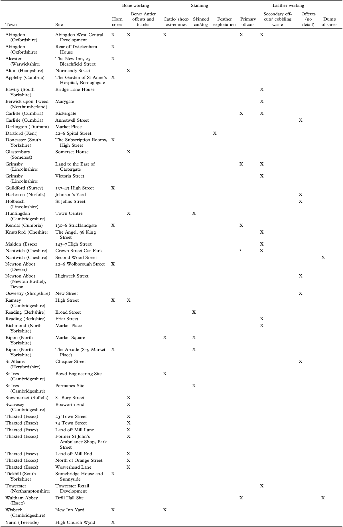
Leather and bone working commonly took place within domestic plots (tab 4). At 8–9 Market Place, Ripon (North Yorkshire), a later fourteenth-century pit contained horn cores, suggestive of horn working, and partial cat skeletons, implying pelt processing.Footnote 60 At New Street, Oswestry (Shropshire), the occurrence of leather, lace tags and an awl from a thirteenth–fourteenth-century well suggests domestic-scale leather working.Footnote 61 Leather working is also attested in the Escheators’ records. In 1407/8 John Brounflete of Burton upon Stather (Lincolnshire) had cobbler’s tools, and in 1423/4 the glover John Tyrell of Cirencester (Gloucestershire) had sixty dried skins, as well as 180 fleeces, suggesting relatively intense production.Footnote 62 At 45–52 High Street, Ramsey (Cambridgeshire), cattle, sheep and goat horn cores, all exhibiting evidence of sawing, were associated with two lined pits, possibly used for soaking horn.Footnote 63 These industries are likely under-represented archaeologically, due to the poor survival of leather and the dumping of waste elsewhere.
Examples of evidence for bone and leather working from archaeological excavations in small towns (see supplementary materials for expanded version).

Table 4. Long description
The table has 10 columns and 45 rows, including headers. The columns are Town, Site, Bone working (Horn cores, Bone/Anler offcuts and blanks, Cattle/sheep extremities), Skinning (Skinned cat/dog, Feather exploitation), Leather working (Primary offcuts, Secondary offcuts/ cobbling waste), and Offcuts (no detail), Dump of shoes. The table lists various towns and specific sites within those towns, indicating the types of activities related to bone working, skinning, and leather working that took place at each site. Each row provides details on the specific activities observed at the listed sites.
These evidential challenges are illustrated by the complex sequence of activity, comprising house structures and occupation layers interleaved with flood deposits, dating between c 1250–1600 at Market Mews, Wisbech (Cambridgeshire).Footnote 64 Despite excellent waterlogged preservation of successive occupation layers, including the deliberate build-up of floor surfaces, there is very little evidence for household activities, suggesting that remains were removed through routine domestic waste disposal. The earliest such evidence is a bone needle, recovered from a floor surface. Between c 1350 to 1450 the house was subject to repeated flooding episodes. From this period, two stone spindle whorls were recovered from floor surfaces. A substantial change occurs in the fifteenth century, when a second structure was erected. Its floor incorporated waste from the melting and reworking of copper alloy and iron, the distribution of which indicates a clear delineation between industrial and domestic space.
This association between domestic space and metalworking is replicated elsewhere. That slag could easily be moved around the townscape is well illustrated at Yarm (North Yorkshire). At 101 High Street, there is evidence for both iron smelting and smithing being undertaken in the fourteenth century, with slag being associated with an area of burning likely indicating the presence of a furnace, suggesting metal production or working on site. In contrast, smithing slag from thirteenth-century make-up layers at 11 High Street is more likely re-deposited.Footnote 65 Smithing slag is commonly recovered but can only be confidently associated with iron working sites where it occurs in high quantities or in association with hearths or workshop structures. For example, at Leominster (Herefordshire) a substantial dump of smithing waste at Buttercross suggests the presence of a smithy close to the marketplace.Footnote 66 In some cases, iron smithing was undertaken alongside non-ferrous metalworking. At The Angel of Corbridge, Corbridge (Northumberland), workshops that incorporated hearths or furnaces were erected adjacent to existing, presumably domestic, structures in the twelfth–thirteenth centuries, and at County Sports, Staines (Surrey), a fourteenth–fifteenth-century workshop is evidenced by furnace or hearth bases and metallurgical waste.Footnote 67 A similar mix of metallurgical processes occurred in the thirteenth–fourteenth centuries at Church Street, Bawtry (South Yorkshire).Footnote 68
Later evidence for bronze casting within a domestic plot comes from 35 West Street, Crediton (Devon), where a sixteenth-century forge producing bronze bells and vessels was excavated.Footnote 69 Contemporary and similar evidence comes from 2 Rose Street, Wokingham (Berkshire).Footnote 70 In Winchelsea (East Sussex) a hearth, associated with pewter drips, appears situated within an ancillary structure at 1 Stand Plat, and at Mill Road there was slight evidence of later medieval bronze working.Footnote 71 Metalworking also took place in peripheral locations, perhaps situated to capitalise on passing trade. At the Victoria Works, Dursley (Gloucestershire), several thirteenth-century smithing hearths were banked up against structural walls on Long Street.Footnote 72 At the similarly peripheral 35 West Street, Wilton (Wiltshire), there is evidence for thirteenth-century iron smithing and copper alloy working in the form of a smithing hearth base and crucible fragments. At Romeland Hill, St Albans, excavations identified a house with associated store building and smithy, with a bronze working crucible being recovered from nearby thirteenth–fourteenth-century make-up layers.Footnote 73
Some hearths may relate to the cloth industry, as at Church Street, Romsey (Hampshire), a town specialising in dyeing, where multiple tile hearths were excavated.Footnote 74 A furnace situated within an ancillary building at Chipping Sodbury (Gloucestershire), adjacent to the River Frome, may have had a similar function.Footnote 75 Postholes indicating drying racks have been identified at Winchester Street, Andover (Hampshire), Station Hill, Chudleigh (Devon), South Gate Street, Bath (Somerset), and Brandon Road, Thetford (Norfolk).Footnote 76 In the Escheators’ records, explicit evidence for cloth production can be seen in the occurrence of looms, including in the lists of weavers and of the dyer William Whyston of Lewes (East Sussex),Footnote 77 who also had various dyestuffs. At Coggeshall (Essex), Richard Ranlyn had a loom as well as a several tools used for separating threads.Footnote 78 Looms also occur in the homes of those not identified as textile workers, such as the husbandman Thomas Sibsaye of Holbeach (Lincolnshire), who had six worn (debil) looms, as well as baking and brewing equipment.Footnote 79 The best archaeological evidence comes from the Swan Hotel, Lavenham (Suffolk), where multiple furnaces associated with a later fifteenth-century dyehouse were excavated.Footnote 80 Lavenham’s economy was dominated by the cloth industry and it falls within a group of towns with highly specialised economies.
LANDSCAPES OF INDUSTRIAL SPECIALISATION
Some towns, by virtue of their proximity to raw materials or marketing networks, specialised in specific, or associated, industries.Footnote 81 These offer a means to explore how industry works across scales from the household to the townscape. We focus on three groups of towns: those specialising in iron production, those with extensive salt production and specialising in the production of ceramics, as well as the town of Thaxted (Essex), which specialised in cutlery manufacture.
Much of England’s iron was imported and domestic iron smelting is typically associated with isolated rural areas,Footnote 82 represented archaeologically by smelting waste such as tap slag and fired clay furnace bases. Although iron occurs across England, the best and most extensively exploited deposits are those in the Weald of Kent and Sussex, the Forest of Dean and along the Jurassic Ridge.Footnote 83 It is from these areas that urban evidence for smelting is concentrated. In the Weald, evidence comes from Crawley (West Sussex) and Horsham (West Sussex).Footnote 84 Smelting occurred at Weldon to the east of Rockingham Forest (Northamptonshire), an area of intensive iron and charcoal production.Footnote 85 In the Forest of Dean, smelting is evident at Coleford (Gloucestershire) and Lydney (Gloucestershire), where sixteenth-century remains are associated with a blast furnace.Footnote 86
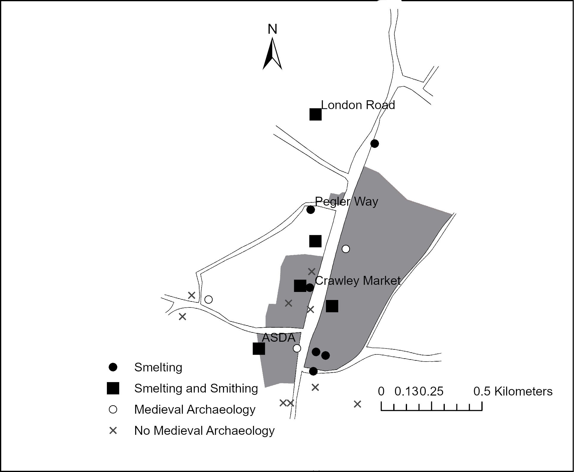
Crawley and Weldon provide extensive but contrasting evidence for the organisation of iron production. The urban status of both is contested; Crawley acquired a market in 1202 but was not a borough and declined considerably following the introduction of the blast furnace in the sixteenth century. Weldon does not have a chartered medieval market, but is recognised as a market town around 1600.Footnote 87 At London Road, Crawley, situated at the northern end of the town, a large fourteenth–fifteenth-century keyhole-shaped bloomery furnace operated alongside a smithy, represented by multiple floor surfaces incorporating hearths and large quantities of hammerscale, with limited evidence for ore roasting (fig 4).Footnote 88 The undertaking of smelting and smithing in close proximity mirrors the arrangement at other sites such as High Street, Yarm, and Godmanchester (Cambridgeshire).Footnote 89 At the southern end of Crawley there is similar, but less compelling, evidence for both processes taking place at the ASDA site, with smelting evidence also occurring to the rear of plots along High Street.Footnote 90 Slag is abundant as hardcore, used in the filling of cut features and the making up of ground levels. Other industries took place within the town, occurring on sites with clear evidence for iron production. These include tanning (on the basis of zooarchaeological remains) at Crawley Market and flax processing at Pegler Way (in the form of a wooden scutching knife recovered from a waterlogged pit) and the ASDA site (in the form of archaeobotanical evidence from dump deposits within a well).Footnote 91
Map showing distribution of iron production and working evidence in Crawley. Image: authors.

Direct evidence for smelting is scarcer at Weldon, but there are two striking contrasts with Crawley. The first is the general absence of smithing waste and the second is the apparent association between furnaces and domestic structures. At Deene End, excavated slag runs are associated with the latest phase of activity around a stone-built tenement complex that includes a kitchen or bakehouse.Footnote 92 A fourteenth-century pit behind a building at Hardwick’s Field contained abundant slag, while slag and associated environmental evidence for fuel at Dash Farm Close support smelting on site.Footnote 93 Further evidence for smelting is provided by two stone furnace bases from Church Walk.Footnote 94
The association between intensive and specialised industrial production is evident in the organisation of Thaxted’s cutlery industry. At Weaverhead Lane, intensive bone handle manufacture, represented by 320 offcuts, may be associated with a slight structure that was out of use by the sixteenth century.Footnote 95 At Town Street, faunal assemblages comprise a mix of domestic and industrial waste, implying production took place in or around ‘domestic’ space.Footnote 96 At 34 Town Street, excavated materials include iron slag, probably from smithing, an iron punch and copper alloy fragments, suggesting rivet production. The close link between bone and metalworking is suggested by a smith being resident on Weaverhead Lane in 1393.Footnote 97 The presence of eleven smiths and seventy-nine cutlers in the 1381 poll tax returns speaks to the specialist nature of Thaxted’s economy and the scale of its cutlery industry.Footnote 98 Thaxted therefore demonstrates the inter-relations between industries necessary for specialised commodity production.
Other industries, such as salt production, were undertaken in specialist areas, as is the case at Droitwich (Worcestershire) and Nantwich (Cheshire), where it took place away from the settlement core. At Droitwich, it is focused on Upwich, north of the River Salwarpe, an area exploited since the Iron Age. The location of salt wells is determined by (known) brine springs, with the town developing on higher, dryer, land to the south. Excavations at Upwich identified the thirteenth–fourteenth-century brine well and associated buildings. From 1215 the brine well was held by Droitwich’s burgesses for an annual fee of £100 and production was heavily supervised by borough officials to maintain prices.Footnote 99 At Nantwich, evidence for salt production comes from the west of the River Weaver, where salt houses were in operation from the twelfth century, with there being around 400 in operation in 1530. Those excavated at Second Wood Street were established in the thirteenth century, following a period of dumping, perhaps to consolidate damp ground, and were periodically rebuilt through to the sixteenth century.Footnote 100 As at Droitwich, the industrial area is distinct from the urban core, which is primarily situated to the east of the river, although there may have been suburban growth to the west of the industrial area.Footnote 101
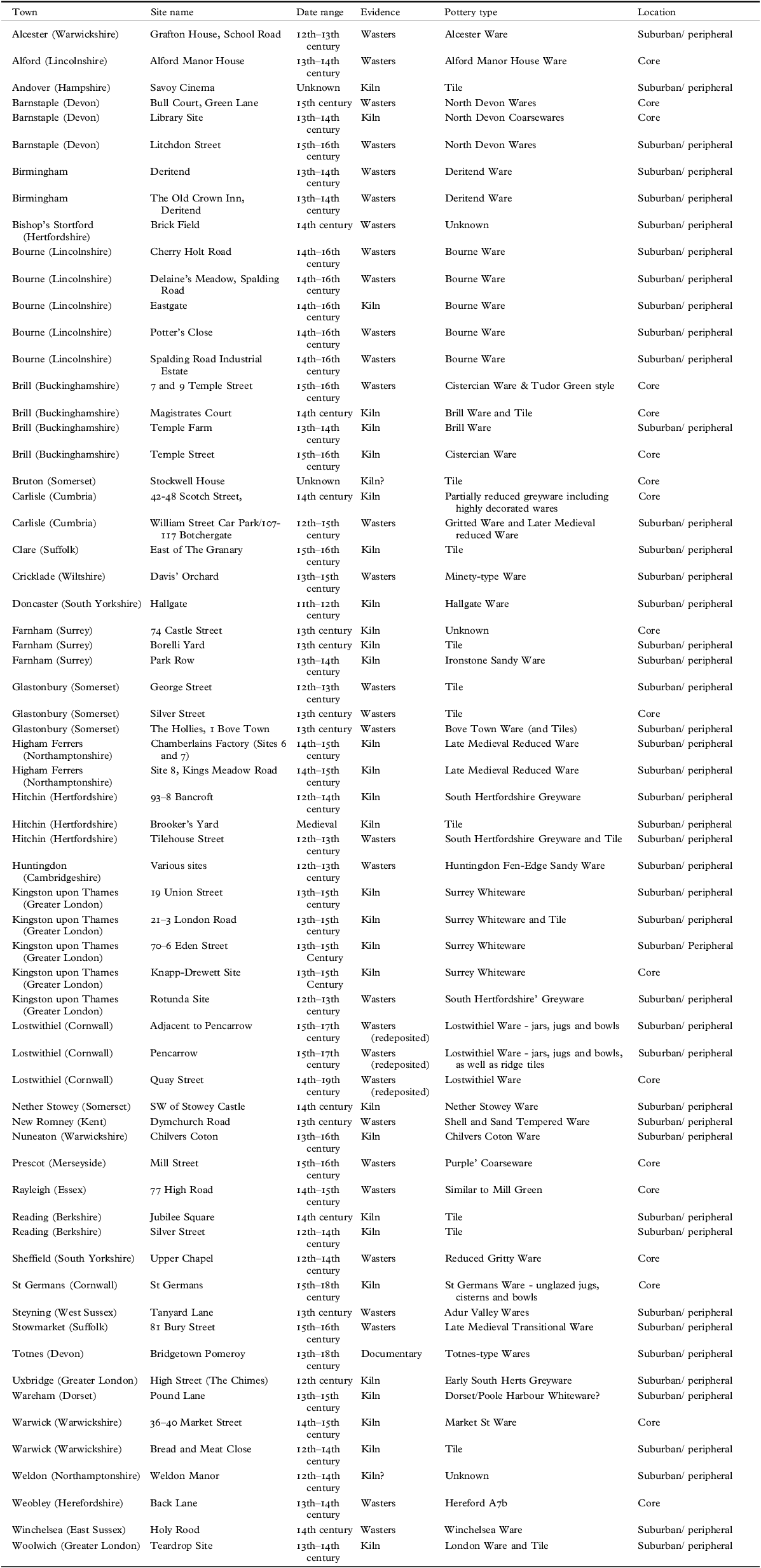
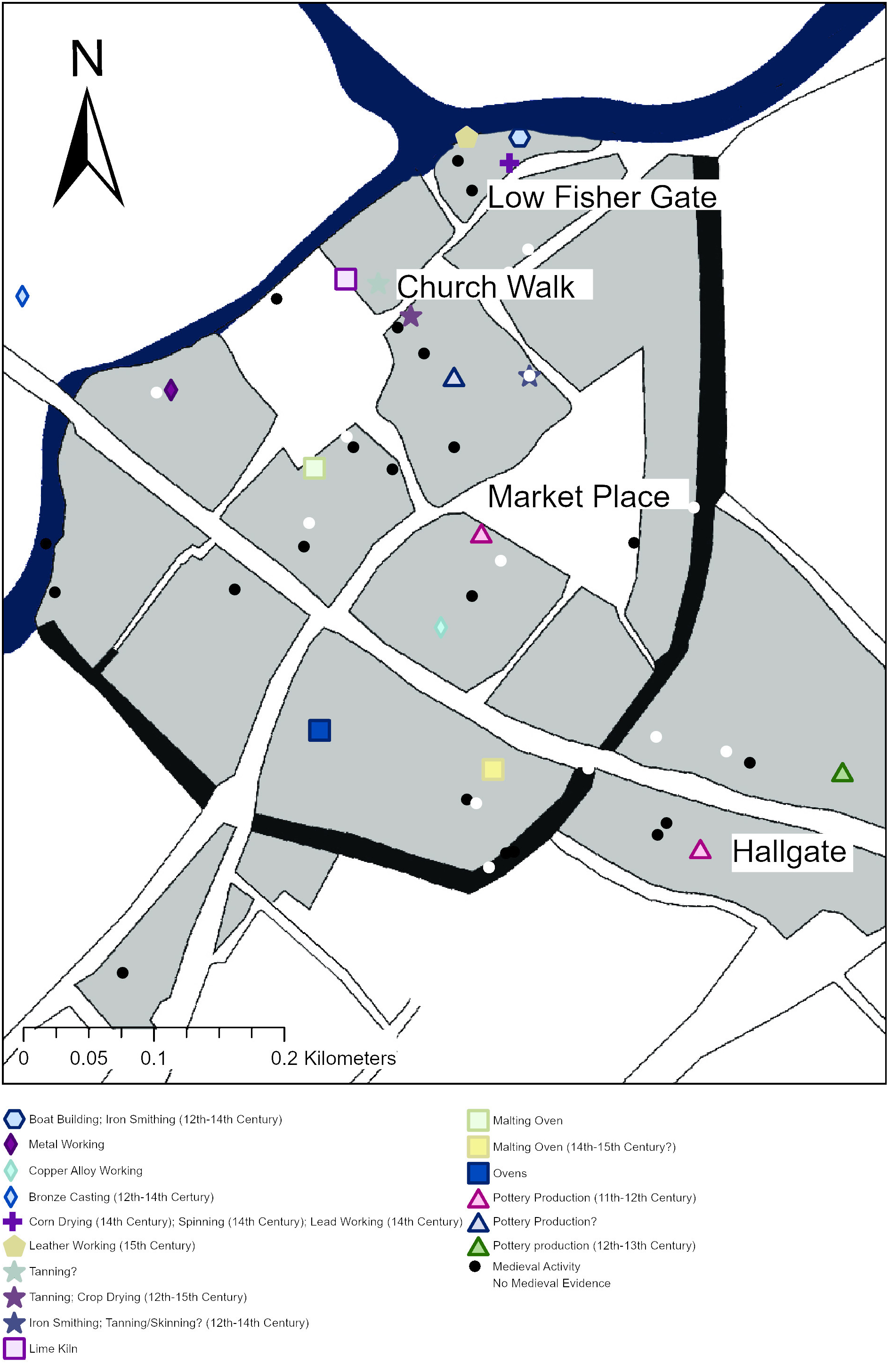
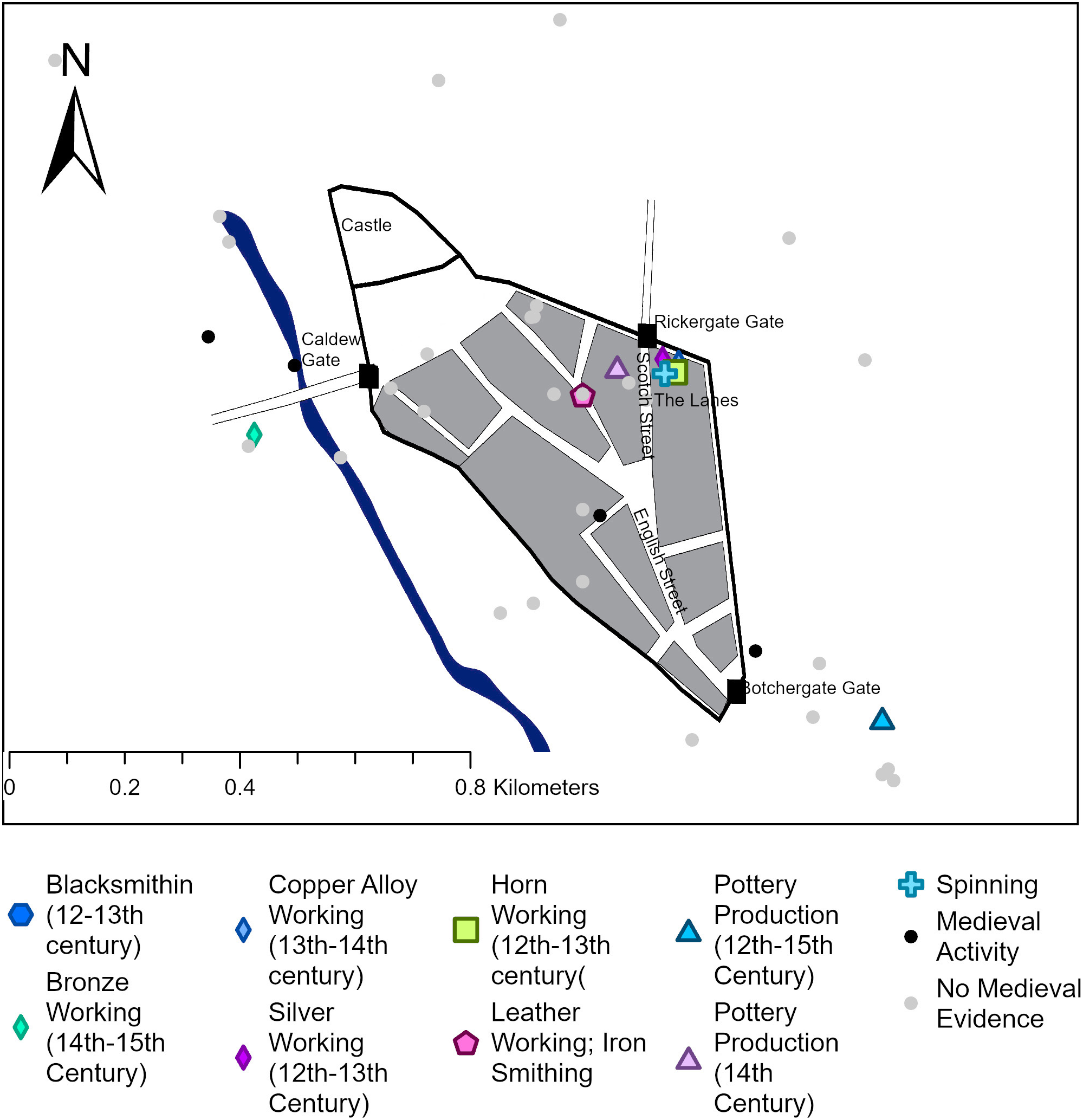
Industries interface with domestic space and the wider landscape in specific ways; salt production was organised around the needs of extraction, iron and cutlery production were activities which could be undertaken in and around domestic space. The ceramic industry offers a further perspective, with most small-town evidence coming from suburban or peripheral areas (tab 5). At Hitchin, tile production was focused at the southern end of the town, around Tilehouse Lane, close to the priory (likely the industry’s main customer), with pottery production occurring here and at the northern end of the town at Bancroft, where an excavated pottery kiln does not appear associated with domestic activity.Footnote 102 There is some evidence for pottery production within towns. At Doncaster (South Yorkshire), an eleventh–twelfth-century kiln was excavated at Market Place, with production shifting to the more peripheral Hallgate in the twelfth–thirteenth centuries.Footnote 103 Fourteenth-century intermural production is evident at Scotch Street, Carlisle,Footnote 104 and at Farnham (Surrey) thirteenth–fourteenth-century pottery kilns occupied some plot tails.Footnote 105 At Barnstaple, a thirteenth-century kiln was identified in the north-west of the town, close to the castle ditch, with suburban production established at Litchden Street in the sixteenth century.Footnote 106
Archaeological evidence for pottery and tile production in small towns (see supplementary materials for expanded version).

Table 5. Long description
Panel A: Table with columns for Town, Site name, Date range, Evidence, Pottery type, and Location. Each row lists specific details for various towns and sites. Panel B: Detailed descriptions of archaeological evidence for pottery and tile production in small towns, including specific locations and historical contexts.
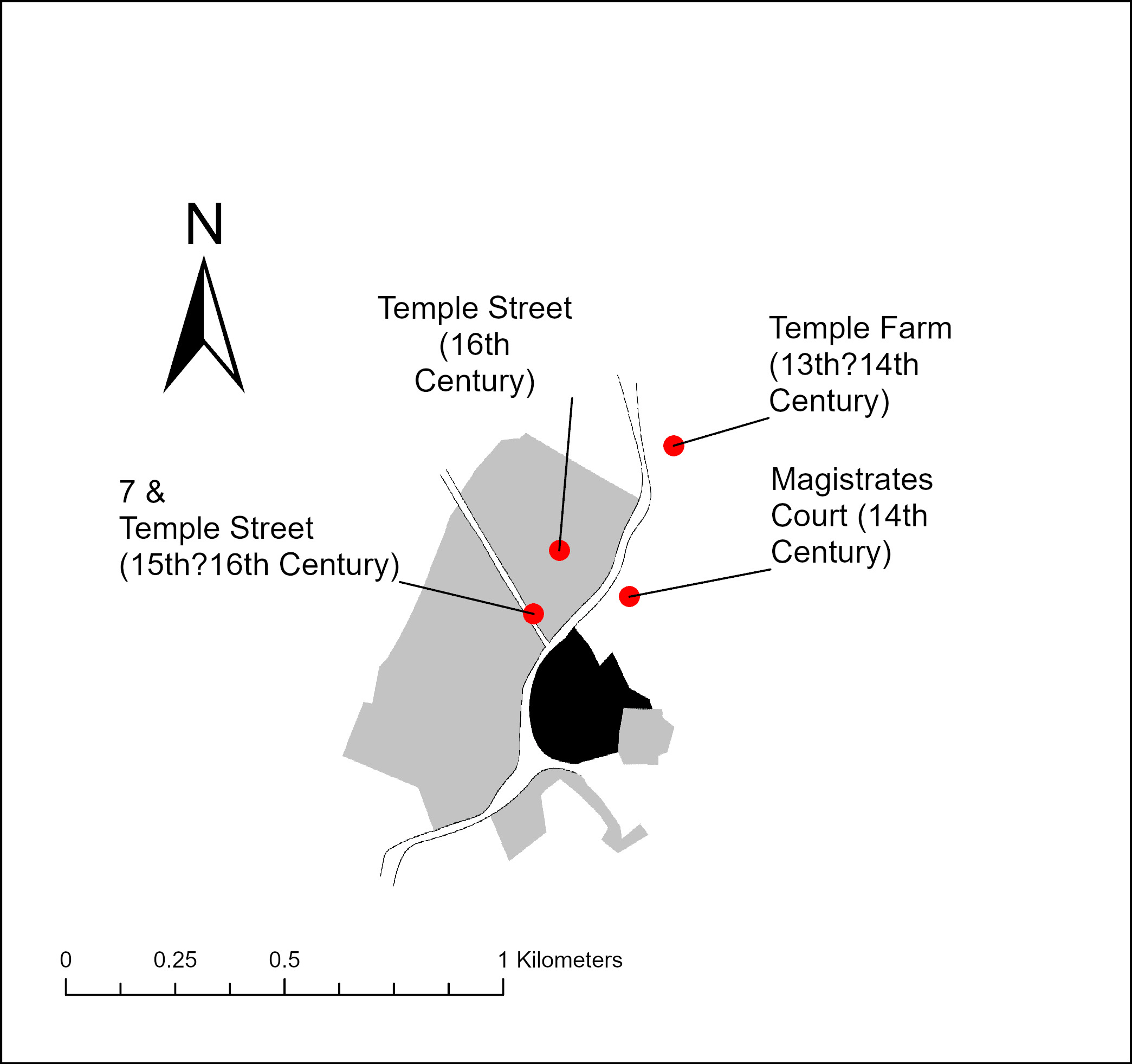
There is not a straightforward relationship between pottery production and suburban or peripheral areas, with the location of production sometimes changing over time. At Brill (Buckinghamshire), a major pottery production centre between the thirteenth–sixteenth centuries, the opposite pattern – of production moving into the town – is evident (fig 5). The earliest kilns, at Temple Farm, are within open ground north of the town.Footnote 107 Fourteenth-century pottery and tile kilns were excavated adjacent to the former magistrate’s court on Temple Street, opposite postulated building plots and adjacent to a site that appears vacant at this time.Footnote 108 In the fifteenth–sixteenth centuries, production occurs within plots fronting the western side of Temple Street, indicating a movement of production closer to the settlement core.Footnote 109 An absence of contemporary domestic evidence suggests abandoned plots were re-purposed for industrial use. The movement of the industry relates to Brill’s economic and demographic development. Brill’s growth was stimulated by the presence of a royal hunting lodge, but was stunted by the passing of the manor out of the Crown’s hands in 1324. This perhaps accounts for the first movement, evident at on the eastern side of Temple Street, with a falling population from the fourteenth century creating vacant plots on the western side that could be taken over by potters’ workshops.
Map showing the locations of pottery production in Brill. Image: authors.

In contrast, pottery production at Bourne was situated in the suburban Eastgate, with an apparently close relationship between production and domestic space. Multiple excavations have identified fourteenth–sixteenth-century kilns, waste, quarry pits and working surfaces. This area was vulnerable to flooding, evidenced in several archaeological sequences. Clear evidence of an association between domestic and production activity comprises a stone house excavated adjacent to clay pits and a possible pot drying area, and the two medieval kilns identified along with early post-medieval domestic and workshop structures at Cherry Holt Lane.Footnote 110
There is no single topography of urban industrial specialisation. Thaxted shows how specialisation could emerge within domestic space. The spatial relationships between domestic and industrial activities vary according both to the needs of the industry, as seen with salt production, but also in relation to specific local patterns of urban growth and development, as seen in relation to pottery and iron production.
INDUSTRIES, INSTITUTIONS AND URBAN DEVELOPMENT
Industries such as quarrying and metal production played an important role in urban development and expansion. Quarry pits occur both within plots, probably representing occasional need for sand or gravel, and in apparently undeveloped areas. At Cider Mill Lane, situated at the northern periphery of Chipping Campden (Gloucestershire), several quarry pits followed the veins of bedrock and were filled with material including twelfth–thirteenth-century pottery, likely relating to the growth of the town around 1180. An associated hearth, which had at least two episodes of use, and postholes suggest the presence of a shelter used by quarry workers.Footnote 111 At Brick Kiln Street, Evesham (Worcestershire), and Moulsham Street, Chelmsford (Essex), quarry pits appear related to sixteenth-century suburban development.Footnote 112
Features relating to specific building projects may include lime kilns at Olive Street, Hartlepool (Teeside),Footnote 113 probably associated with works to the town wall, and at Chesterfield (Derbyshire) where they relate to church works.Footnote 114 At Fairford (Gloucestershire), a building adjacent to the church functioned as a glaziers workshop, with evidence of lead and glass working being found.Footnote 115 Similar evidence came from 56 The Spittal, Castle Donington (Leicestershire), associated with the construction of the hospital of St John.Footnote 116
Evidence for metal production and working can also be associated with specific demand. At Tonbridge (Kent), excavations at the cattle market recovered substantial quantities of smelting and smithing waste.Footnote 117 While falling within the pattern of Wealden iron production, the site’s location adjacent to the marketplace and just beyond the extent of the castle, may relate to a forge documented in an inventory of Tonbridge Castle in 1325. A similar association can be proposed at Battle (East Sussex), where a smelting furnace base was identified at 85–6 High Street, opposite the gates of the abbey, and at Friars Walk, Lewes, situated close to Lewes Friary.Footnote 118 Although detailed analysis of evidence from urban religious houses falls outside the scope of this paper, it is worth noting that industry, most commonly tile production, did occur within their precincts. The high-quality tiles produced at Chertsey (Surrey) and Coggleshall are the work of skilled artisans.Footnote 119 More functional products were produced at Dunstable (Bedfordshire), where a kiln producing roof tiles was excavated at the edge of the Friary precinct.Footnote 120 Whereas kilns were probably associated with works to the institutions themselves, Ramsey Abbey, where multiple tile kilns have been excavated, sold tiles from the fourteenth century and bricks from the mid-fifteenth century. Here there is also evidence for ferrous and non-ferrous metal working, primarily dating to the twelfth century.Footnote 121 Larger scale metalworking is evident at Waltham Abbey, where excavations identified the monastic forge.Footnote 122
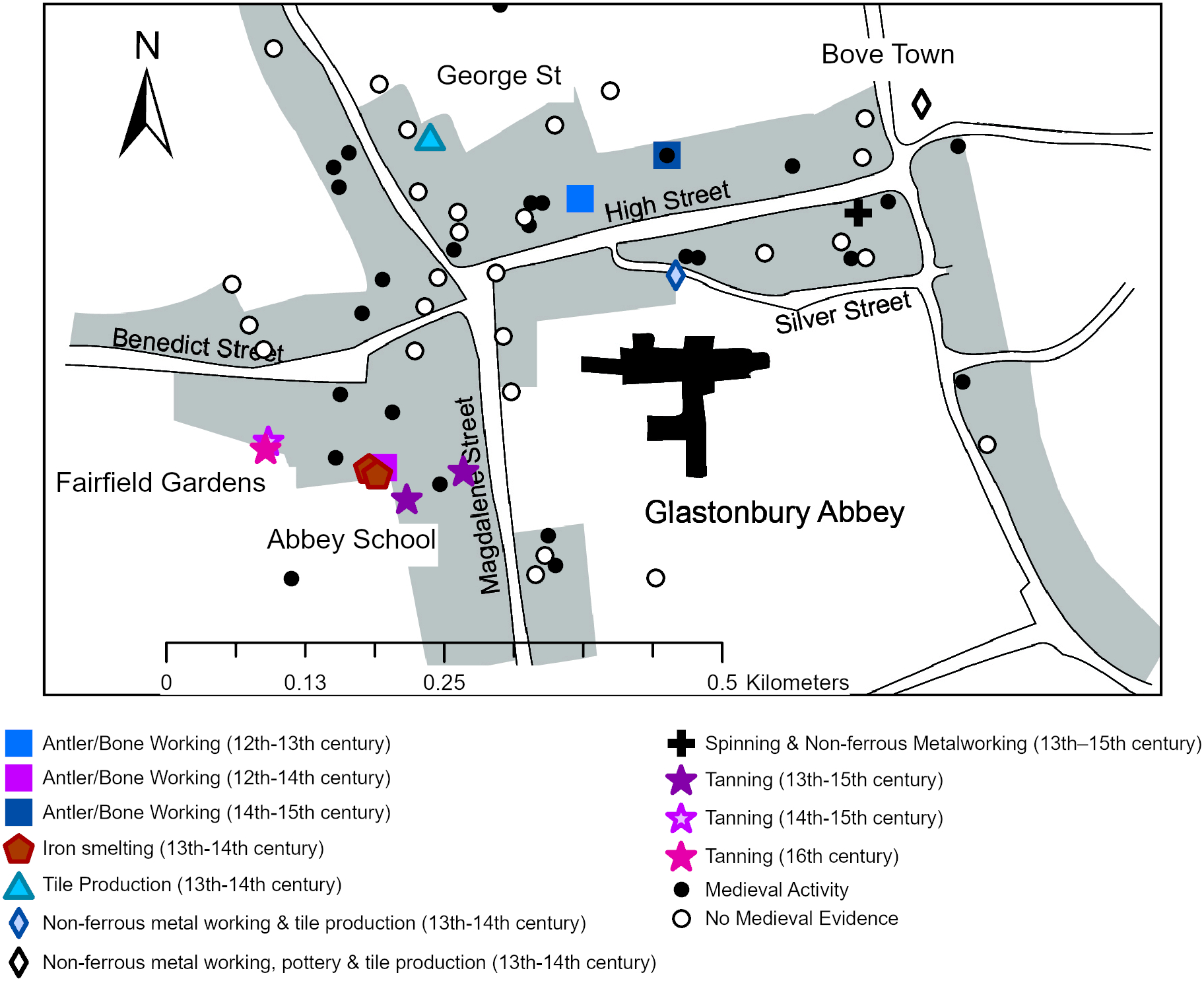
The relationship between institutional demand and urban production can be further investigated through the case of Glastonbury (Somerset) (fig 6). Tile and iron production were directly associated with Glastonbury Abbey. At the suburban 1 Bove Town, tiles that chemically match examples from the abbey were produced in the thirteenth–fourteenth centuries.Footnote 123 No kiln was excavated, but the concentration of waste material suggests that it lay to the north of the excavated area. Additional evidence of tile production comes from waste material at George Street,Footnote 124 another peripheral site, and at Silver Street, where a dump of floor tiles were found adjacent to the abbey precinct.Footnote 125 At Bove Town there is also evidence for a later thirteenth- or early fourteenth-century pottery industry producing highly decorated jugs that, in contrast to the tiles, were not abundant at the abbey, implying an attempt to develop a market-facing industry. At Heritage Court, opposite the abbey’s west gate, considerable quantities of slag, dated by associated pottery to the twelfth–fourteenth centuries, likely indicate the location of the documented abbey forge.Footnote 126 From the fourteenth century, this area, located south of High Street, developed an industrial character. At Abbey School, tanning pits were situated behind plots fronting Magdalene Street, within an area that appears to have become increasingly damp.Footnote 127 Further evidence of, primarily fifteenth-century, tawing was found further west at Fairfield Gardens.Footnote 128
The distribution of industries in Glastonbury. Image: authors.

The tanning industry met the needs of both the abbey and the market. At 1 Bove Town there is also evidence of non-ferrous metal working, an industry that also took place at Silver Street, where hearths of a possible foundry were recorded, and is suggested by crucible fragments recovered from a late thirteenth–fifteenth-century ditch on High Street.Footnote 129 Other evidence of craft production includes two spindle whorl fragments from the same ditch at 82 High Street and three find spots of worked antler, including a knife handle rough out.Footnote 130 At Glastonbury we can therefore perceive of the presence of the abbey as well as the physical topography influencing the range and scale of production and the location of industries within the townscape.
INDUSTRIES AND URBAN LANDSCAPES
Glastonbury reflects a general picture whereby industries such as leather and horn working and, to some extent, metal smithing have a close relationship with domestic space, while others, such as tanning and tile production, often took place away from urban plots. This patterning can be further explored with reference to other towns with particularly good evidence.
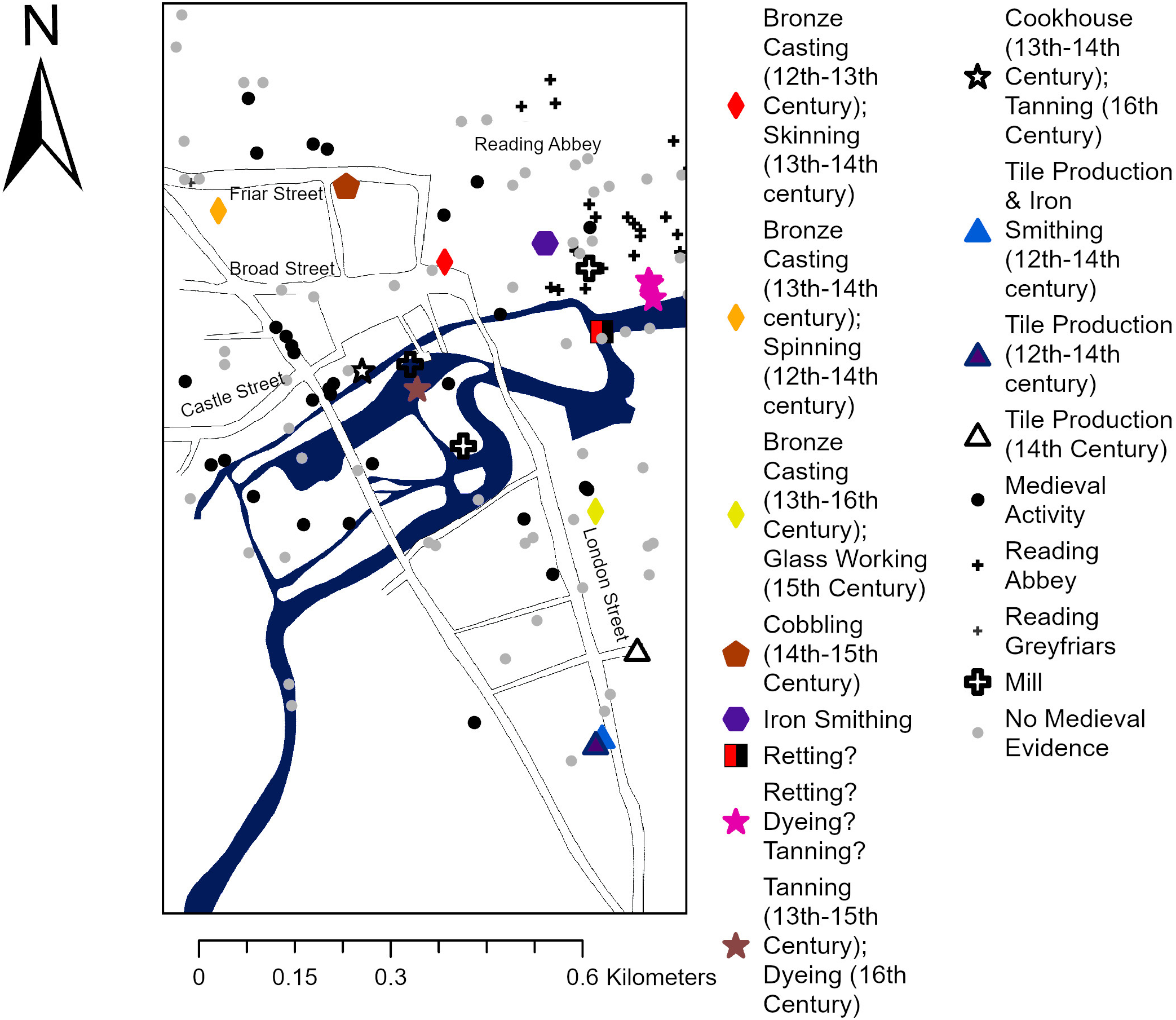
Glastonbury is paralleled at Reading (Berkshire), another monastic town, and at Doncaster (figs 7 and 8). At Reading, kilns producing tiles used at Reading Abbey operated between the twelfth and fourteenth centuries along Silver Street at the southern periphery of the town.Footnote 131 Along London Street, a main route into Reading, there are dumps of mid–late thirteenth–fourteenth-century bronze casting waste (amounting to more than 3kg of slag recovered from a pit that also included hearth debris and mould fragments) and fifteenth-century glass working waste, implying these industries took place within an area of later medieval expansion.Footnote 132 Bronze casting evidence, in the form of mould fragments, also comes from a deposit of mid-thirteenth–fourteenth century date within a domestic plot on Friar Street. A bell-founding pit pre-dates the main phase of domestic occupation at Broad Street.Footnote 133 At both sites, domestic-scale production is evident: skinning, broadly dating from c 1250–1500, at Broad Street and spinning at Friar Street (see tab 3). A fourteenth–fifteenth-century dump of cobbling waste also comes from Friar Street.Footnote 134 At Doncaster, the pottery kiln at Hallgate mirrors the peripheral location of tile and pottery production at Reading and Glastonbury.Footnote 135 There is also evidence for a range of activities within plots, including crop drying and malting. The best evidence comes from Low Fisher Gate, where crop drying, spinning, lead working, iron smithing and boat building or breaking all took place during the thirteenth and fourteenth centuries.Footnote 136
The distribution of industries in Reading. Image: authors.

Fig 7. Long description
A map of Reading, Berkshire, illustrating the distribution of different industries during the medieval period. The map includes labels for specific streets such as Friar Street, Broad Street, Castle Street, and London Street. Key locations include Reading Abbey and Reading Greyfriars. Various symbols represent different industries: Bronze Casting, Skinning, Spinning, Glass Working, Cobbling, Iron Smithing, Retting, Dyeing, Tanning, Cookhouse, Tanning, Tile Production & Iron Smithing, Tile Production, and Medieval Activity. Symbols include diamonds, hexagons, stars, triangles, and circles, each with specific colors and shapes indicating different industries and time periods. The map also shows areas with no medieval evidence.
The distribution of industries in Doncaster. Image: authors.

In both towns, as at Glastonbury, there is substantial evidence for tanning. In Doncaster, this is focused adjacent to the River Don, occurring alongside crop drying (represented by a drying oven) between the twelfth and fifteenth centuries at Church Walk.Footnote 137 At Reading, tanning took place on the Kennet floodplain, away from areas of domestic occupation. At the Oracle, a tannery and later dyehouse, represented by a group of lined pits, in operation from the fourteenth century, were excavated.Footnote 138 Further evidence for tanning, in the form of dumps of horn cores, as well as archaeobotanical evidence suggesting dyeing and retting (the soaking of flax), has been identified at other sites along the Kennet waterfront.Footnote 139
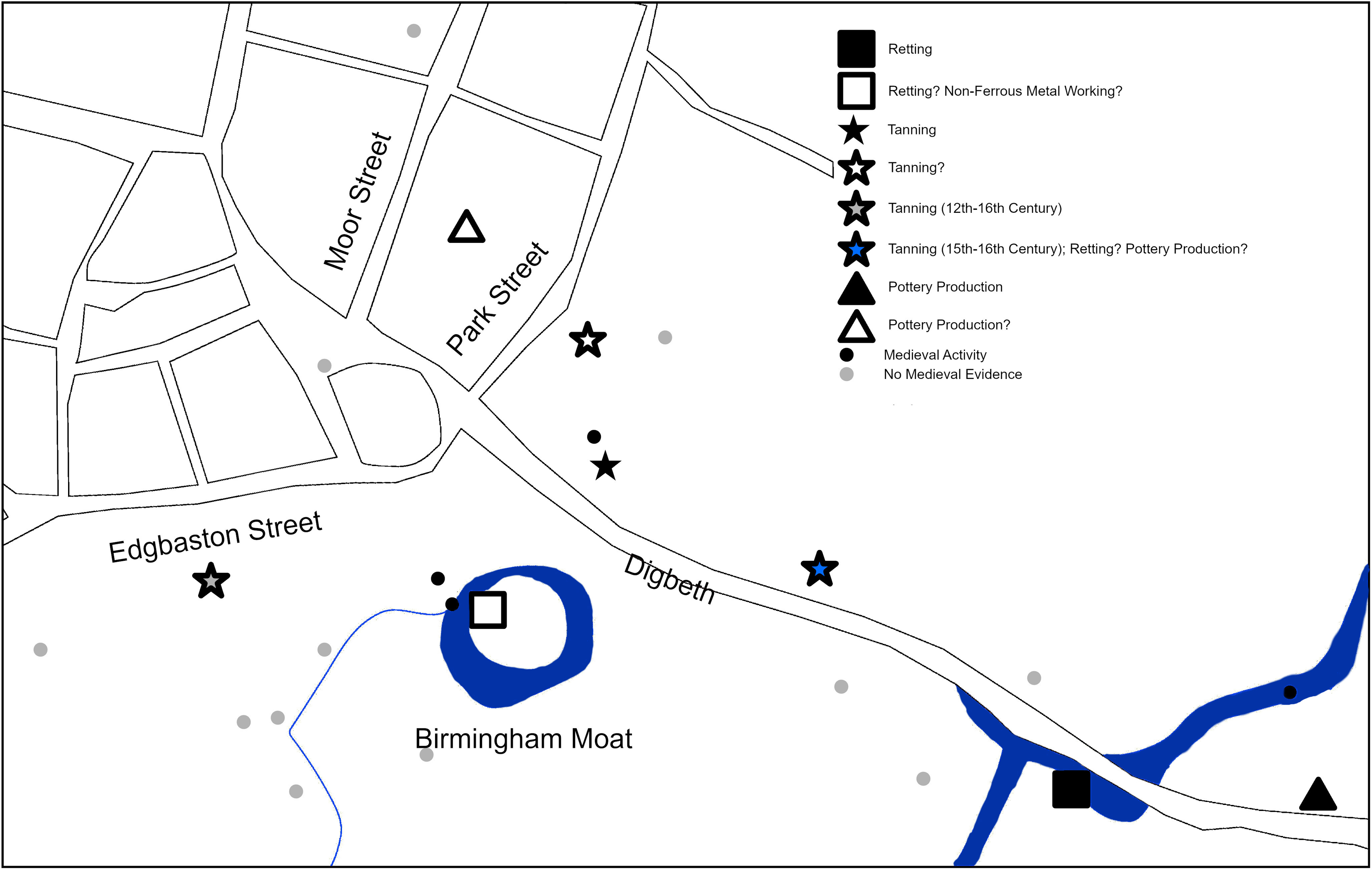
Tanning, retting and dyeing are all industries requiring supplies of water, which undoubtedly accounts for their situation in peripheral, often damp, areas of townscapes. At Birmingham, both natural and manmade water courses were utilised (fig 9). At 170 High Street, Deritend, alluvial deposits related to a former river channel yielded flax seeds, suggestive of retting. Archaeobotanical evidence from Moor Street and Park Street suggests that drainage ditches and the manor moat were used for this industry.Footnote 140 Bundles of waterlogged fibres, a by-product of textile production, were recovered at the Hartwell Smithfield Garage site.Footnote 141 Palynological evidence further supports this industrial focus at Birmingham’s periphery, with evidence for the processing or growing of hemp and flax in the vicinity of The Row and Beorma Quarter sites respectively.Footnote 142
The distribution of industries in Birmingham. Image: authors.

In Birmingham, tanning is evidenced to the rear of the Digbeth frontage and south of Edgbaston Street. Both are relatively peripheral areas situated to the south of the market place.Footnote 143 A close association between tanning and retting can also be seen at Brewood (Staffordshire), where excavations revealed wooden platforms associated with these industries, in a damp area adjacent to a stream (into which there is documentary evidence for the dumping of industrial waste) at the town’s periphery.Footnote 144 Similar evidence for riverside tanning and associated wooden platforms comes from the Drill Hall, Waltham Abbey, at the western periphery of Tickhill (South Yorkshire) and on the waterfront at Eton (Berkshire).Footnote 145 Tidal salt production also took place adjacent to rivers, best evidenced at Millfields Caravan Park, Bramber (West Sussex).Footnote 146
These damp areas, unsuitable for domestic habitation, also attracted industries that were not reliant on a water supply. At Badow Road, Chelmsford, a possible bakehouse was erected on reclaimed land in the later thirteenth–fourteenth centuries.Footnote 147 Similarly, at St Mary’s Street, St Neots (Cambridgeshire), there was a malting or drying kiln and at Rocester (Staffordshire) several thirteenth–fourteenth-century malting kilns, as well as iron smithing debris and deposits of horn cores, perhaps suggesting tanning or hide processing, were excavated adjacent to the River Dove at Church Lane and Dove Lane.Footnote 148 Within ports, damp areas close to waterfronts are a further distinctive zone, often characterised by a mix of maritime industries such as boat repair and fish processing, as well as evidence for pottery production at New Romney (Kent) and grain processing at Ropetackle, Shoreham (West Sussex).Footnote 149 The presence of ovens and kilns supports the interpretation of these peripheral areas as sites of industry rather than waste dumps.
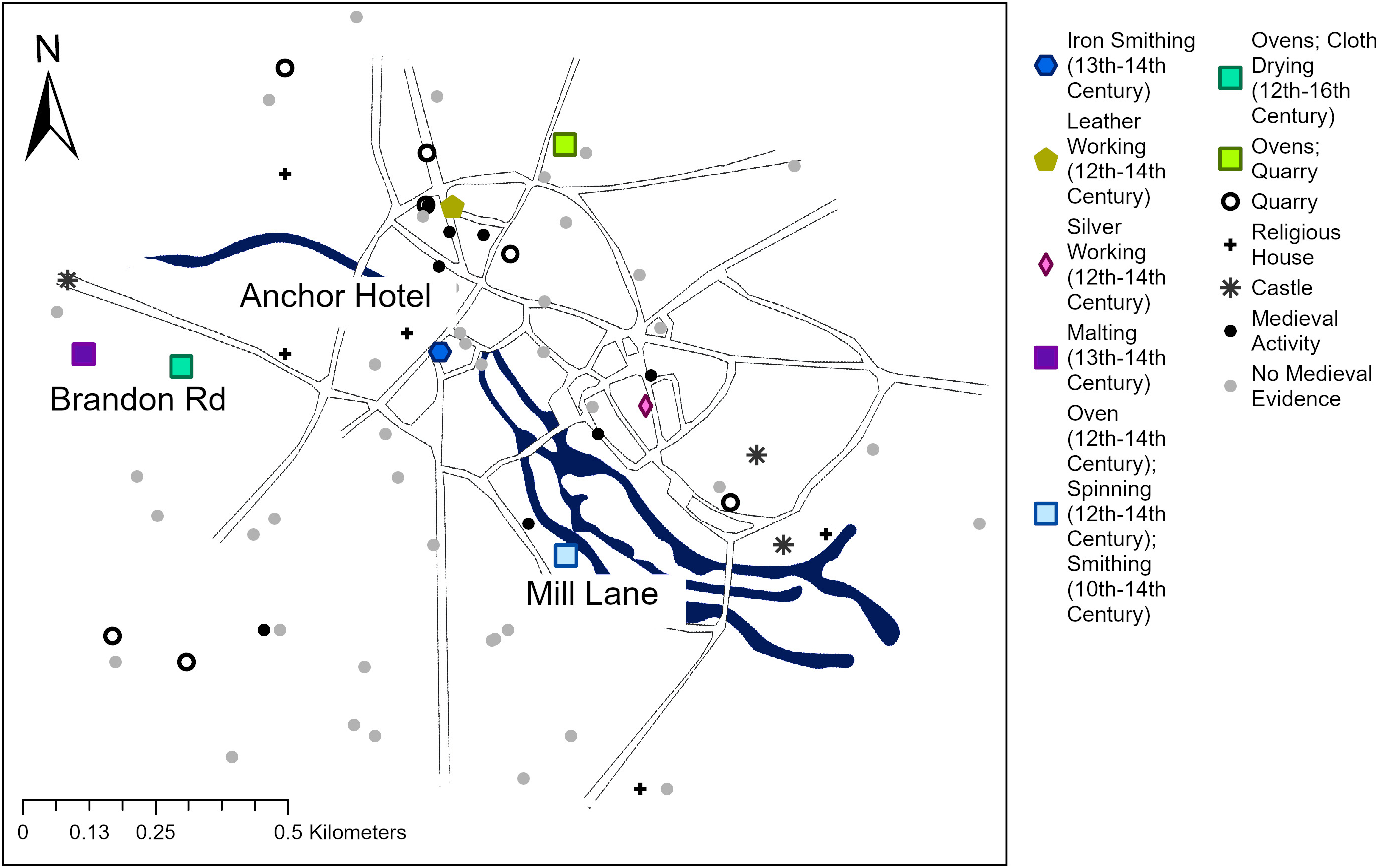
Whilst following these general trends, the location of industries was shaped by the specific circumstances of urbanisation. Thetford had its heyday in the early medieval period. Here, there is considerable evidence for chalk quarrying, both within the urban core and in outlying areas south of the river, and there is also substantial evidence for crop drying and malting (fig 10). At Croxton Road, at Thetford’s northern periphery, an oven was associated with quarry pits, and at Mill Lane, situated south of the river, an oven forms part of a domestic site from which spindle whorls and (possibly residual) iron smithing slag have been recovered from twelfth–fourteenth-century deposits.Footnote 150 This area was intensively occupied in the pre-conquest period but was marginalised as the medieval town developed around the castle. At Brandon Road, another area of intensive pre-conquest activity at Thetford’s western edge, there are multiple phases of crop-drying ovens and posthole settings interpreted as tentering racks.Footnote 151 Also relatively peripheral is the Anchor Hotel site, where a workshop, probably a smithy, was in use in the thirteenth–fourteenth centuries at a site vulnerable to flooding.Footnote 152 Evidence of domestic production within the town is limited. At St Nicholas Street the presence of several awls, as well as possible punches, implies leather working, and at Guildhall Street there is evidence of silver working.Footnote 153
The distribution of industries in Thetford. Image: authors.

At Thetford, contraction resulted in previously intensively occupied areas becoming open ground, creating spaces that could be given over to industrial use but with some industries, such as silver working, retaining their situation within the commercial core. This is a reversal of the trend seen in many towns, where open ground was used for industry prior to development. At Manor Street, Berkhamsted (Hertfordshire), industrial activities including crop processing (evidenced by two ovens), iron smithing and smelting (possibly associated with the castle) and fibre processing (represented by hemp and flax remains in environmental samples) took place before the development of plots around 1350.Footnote 154 Similar evidence comes from Chipping Ongar (Essex), where a series of late twelfth–thirteenth-century ovens occupied an area beyond the town ditch prior to plot development, Kilpeck (Herefordshire), where smithing and smelting debris pre-dates thirteenth–fourteenth-century development, and Marygate, Berwick-upon-Tweed (Northumberland), where large quantities of fish processing waste were recovered from pits pre-dating the fourteenth-century build-up of the street frontage.Footnote 155
At Carlisle, suburban industry developed as occupation within the walled town increased (fig 11). In the early stages of urban development there is good evidence for intermural metal working. At Rickergate, smithing slag and a rare pair of bellows were dumped into a ditchFootnote 156 and, at the Lanes, silver and copper alloy working, as well as blacksmithing, took place in the twelfth–thirteenth centuries. This declined as the area became more intensively built up.Footnote 157 Intermural pottery production took place around Scotch Street in the fourteenth century, and tanning may also have taken place within the walls.Footnote 158 At Caldewgate, a later fourteenth–fifteenth-century suburban bronze foundry was excavated at 17 John Street.Footnote 159
The distribution of industries in Carlisle. Image: authors.

Fig 11. Long description
The map depicts the distribution of industries in Carlisle, highlighting various medieval activities and landmarks. Key locations include the Anchor Hotel, Brandon Rd, and Mill Lane. The map uses different symbols to indicate specific activities such as iron smithing, leather working, silver working, malting, oven use, spinning, and smithing. Religious houses, quarries, castles, and areas with no medieval evidence are also marked. The map shows rivers and roads, with directions indicated by arrows. The legend explains the symbols used for different activities and their respective centuries.
In the South Gate suburb of Bath, historical and archaeological evidence attest to diverse industry. The 1377 poll tax lists dyers, spinners and weavers, as well as a tanner, resident here. An artificial watercourse, likely associated with a mill, was probably used for flax retting during the twelfth–thirteenth centuries. The processing of dyestuffs is suggested by madder stained pottery, cloth finishing by teasel seeds and cloth drying by the postholes of a possible tentering rack.Footnote 160 Several smithing hearth bases were recovered from make-up deposits and road surfaces, from which there was also evidence for leather and hide processing, making it unclear where these processes took place. Similar evidence comes from Leominster, where tanning evidence was identified at the Hop Pole, and industrial furnaces pre-dating the building up of the street frontage were identified at the Meatpackers site, both at the northern edge of the town.Footnote 161 A similar relationship between industry and suburbanisation can be seen in the sixteenth century at Moulsham Street, Chelmsford, where copper alloy working, including casting and the working of sheet metal, took place.Footnote 162
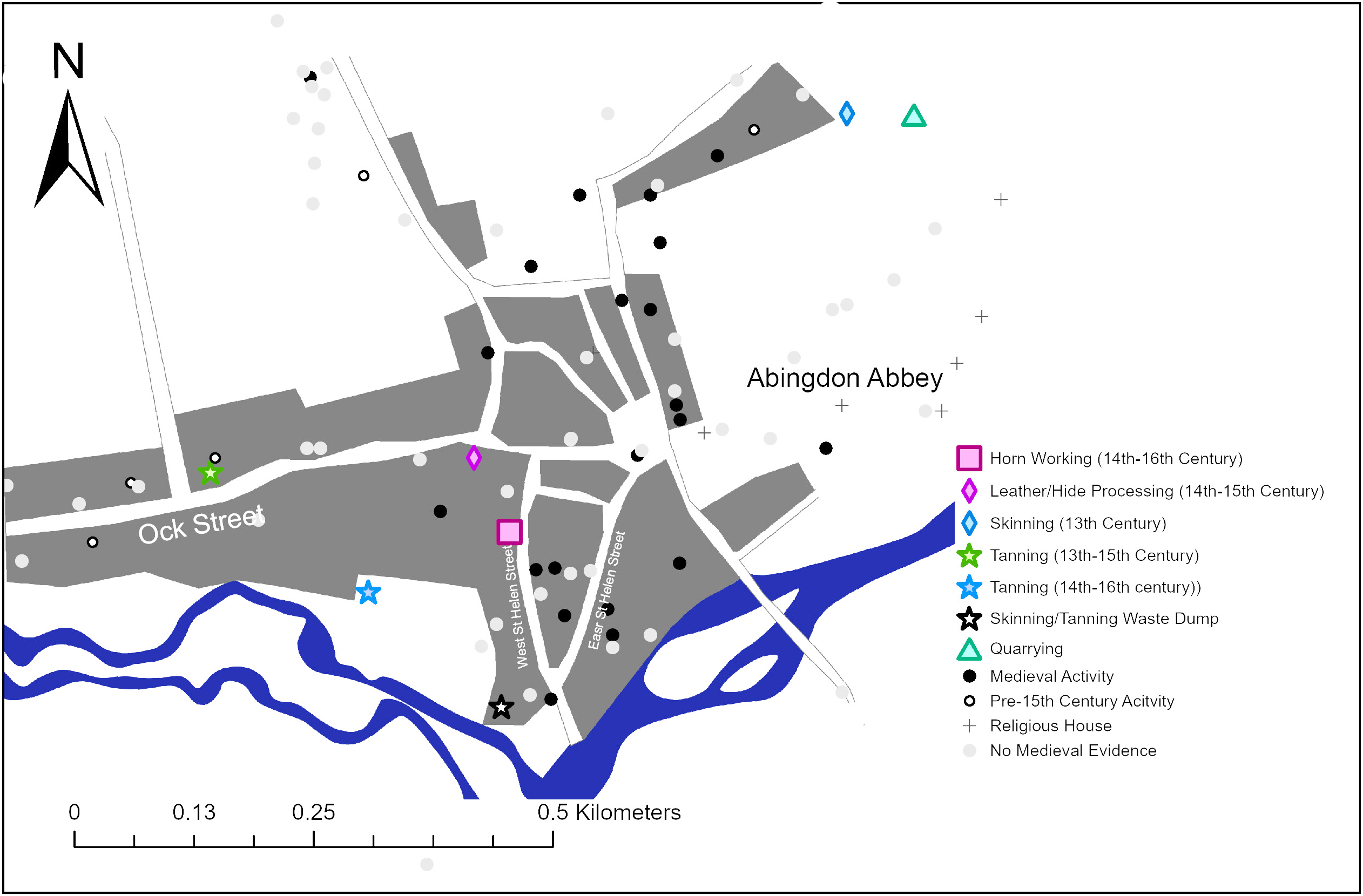
Towns contracted as well as expanded, with industries re-locating into previously occupied areas. At the Seven Stars, Ledbury (Herefordshire), three sixteenth-century tanning pits mark the re-use of a vacant site in the town centre.Footnote 163 Similarly, at St Ives (Cambridgeshire) several inter-cutting ovens were constructed in the fifteenth century, following a period of hiatus.Footnote 164 At Abingdon (Oxfordshire) a tannery at the peripheral 75 Ock Street was in operation between the thirteenth and fifteenth centuries (fig 12).Footnote 165 Corresponding with the end of the industry here, tanning from the later fourteenth century, intensifying through the sixteenth century, is evident to the east at Morlands Brewery, closer to the urban core.Footnote 166 Also on Ock Street, hide processing and leather working took place at the cinema site in the fourteenth–fifteenth centuries based on dumps of faunal material from a yard area that was extended when an earlier house fell out of use.Footnote 167 On East St Helen Street, faunal evidence suggests a shift from domestic to industrial waste, with butchery, horn working and glue making all being suggested.Footnote 168 Together this suggests a general movement of noxious industries towards the core of the town, corresponding with a period of contraction whereby sites in the western and northern periphery appear to have been abandoned.
The distribution of industries in Abingdon. Image: authors.

Evidence from Bedford (Bedfordshire) demonstrates that this was not a simple process of contraction, however. In the fourteenth–sixteenth centuries land at 29–39 St John’s Street, situated at the southern periphery, appears to have fallen out of use. During the twelfth–thirteenth centuries there was a bread oven in operation here, and a kiln may have produced lime for the tanning industry.Footnote 169 Further north, at 5–11 St Mary’s Street, a sequence of fourteenth–fifteenth-century hearths and ovens suggests substantial baking or brewing, implying a movement of this activity from the periphery towards the core; however, evidence from further south along St Mary’s Street and in the wider vicinity is suggestive of continued activity, including some high-status housing.Footnote 170
DISCUSSION
Despite evidential challenges, the archaeological and historical evidence presented here demonstrates a diversity of ways in which industry was organised within small towns. Three key themes emerge: the factors influencing the distribution of industries; the character of small-town industry relative to that in larger towns and the countryside; and the role of institutions in stimulating industrial specialisation.
There is no singular model of industrial zoning within small towns. Multiple industries could take place within single plots, perhaps accounting for seasonal variations in the availability of materials or to complement a main occupation, as suggested for the occurrence of spindle whorls at sites with strong evidence for fishing. Although noxious industries such as tanning and those carrying substantial fire risk, such as pottery production, were often situated in suburban areas, this was not always the case, as seen, for example, at Brill and Ledbury. A re-occurring feature is the exploitation of locations that were damp or flood-prone. In some cases, as with tanning on the Kennet floodplain at Reading and retting in Birmingham, this may have been due to the needs of the processes themselves, while in others this land offered space into which industry could expand without creating pressure on habitable space, as with the pottery industry at Bourne. From the evidence presented, we can propose that three key variables determine the location of industry: the needs of the processes, urban developmental trajectories and the natural environment. The balance between these variables varies contextually; in some cases, as at Thetford, urban contraction created spaces where industry could take place, in others, such as at Carlisle, growth pushed industry outwards. Thinking in terms of these variables offers a flexible model to assess industrial organisation within townscapes contextually and to understand variability.
A key difference between small and larger towns is the diversity of industries undertaken. Here, the Escheators’ records prove instructive. Although individuals are listed by their occupational descriptor, there are few occupations that are strongly specialised. Among the metalworkers, the majority are smiths who worked iron. The importance of textile and leather production is indicated by the diversity of roles associated with these industries (tab 1). The tools listed include specialist items associated with the smithy, looms for weaving and a range of vessels for brewing. A striking contrast is drawn by the occupations referred to in the limited number of analysed Escheators’ records from larger towns: a jeweller among five published from Canterbury, a possible wire drawer and armourer among thirty lists from Winchester and two mercers and a draper among fourteen from Salisbury.Footnote 171 From Fisherton Anger, a suburb of Salisbury, Simon Clokmaker had a clock among his possessions in 1427.Footnote 172 This evidence accords with a general understanding that larger towns have a higher degree of occupational diversity than their smaller counterparts,Footnote 173 with what might be termed ‘niche’ industries, which may be highly skilled, capital intensive or dependent on a small consumer base.
The occupational diversity of larger towns is less evident from archaeology. For example, among the abundant evidence from Norwich and York, most relates to those activities represented in smaller towns: metal, leather, bone and textile working as well as building, carpentry and horticulture. The key difference is not in the range of industries represented, but in the quantity of evidence. This relates, in part, to the scale of excavation but also to a higher intensity of industrial activity.Footnote 174
In summary, historical evidence suggests a greater level of occupational diversity and topographic zoning of industries in larger towns than is evident in small towns, whereas archaeological evidence suggests a similar range of core industries being undertaken at a greater magnitude. The intermediary position of small towns between these larger centres and the countryside is illustrated by the emphasis of small-town economies on the processing of agricultural produce, be that wool, skins or crops, and the production of objects in high demand such as ironwork and pottery. These same industries occur in the countryside; villages such as Lyveden (Northamptonshire) had a large and productive pottery industry,Footnote 175 whilst analysis of rural Escheators’ inventories and archaeological evidence has provided strong evidence for activities such as the extraction, smelting and smithing of metals, tanning and textile production, particularly the early stages of carding and spinning.Footnote 176 A key difference emphasised by rural Escheators’ lists is the balance between industry and agriculture, with rural artisans typically undertaking industry alongside sometimes quite extensive agricultural production.Footnote 177 Rather than marking a clear divide between town and country, it is more useful to think about the balance between agricultural and industrial activities as varying contextually. A key direction for future research is examining this balance regionally and over time.
A final theme is the role of institutions in stimulating industrial production. Casson and Casson demonstrate statistically that religious institutions were a key stimulant of urbanisation.Footnote 178 As shown at Glastonbury and Reading, religious institutions stimulated an industrial and service economy, but, as at Ramsey and Waltham Abbey, institutions could operate as industrial concerns in their own right. Seeing these institutions as causing industrial development risks a circular argument; of many of the most successful towns that have the best evidence for industry, places such as Abingdon, Reading and Doncaster had castles and religious houses, but have also been subject to the most extensive excavation. What can be said is that the presence of these institutions was clearly one of several factors that stimulated specific developmental trajectories. Environmental and topographic factors also played a role, most evident in the way that activities such as spinning and boat repair are evident in settlements where fishing was important, the growth of specialised iron industries in Wealden towns or the development of cloth production in the south-west in places such as Dunster (Somerset), where fast-flowing streams powered fulling mills and the surrounding countryside offered prime sheep grazing.Footnote 179 It is this mix of factors that, as with the situation of industries within towns, means we cannot present a singular narrative of industrial development but must instead firmly situate it within the specific geographical and institutional context of individual towns.
CONCLUSION
Although not providing a comprehensive overview, our analysis illustrates broad trends between small towns and some relationships between industrial processes and urban development. We have highlighted how many industries took place within domestic space, that households could adopt mixed economic strategies and the importance of marginal areas such as damp or flood-prone ground, which was particularly well suited to industries.
We have also argued for the importance of contextualising the limited evidence for industrial production, with both its spatial organisation and the economic basis of individual towns not following a singular model but emerging in relation to the developmental history of urban landscapes, environmental and institutional factors. The need for interdisciplinary analysis is evident; while historical sources illustrate contrasts in occupational diversity between larger and smaller towns, this is less evident archaeologically.
Finally, we have demonstrated the importance of considering the intersections between different industries as key elements of specialisation; knife production at Thaxted required collaboration between smiths and bone workers, fishing at Dover necessitated the production and maintenance of nets. We hope that this paper has demonstrated the potential and richness of the archaeological and historical material for medieval small towns and can provide a future basis for understanding their role in processes of economic and urban development.
SUPPLEMENTARY MATERIAL
The supplementary material to accompany this article can be found online at https://doi.org/10.1017/S0003581526100675.
Underpinning archaeological and historical data are available in the ENDURE project archive hosted by the Archaeology Data Service https://doi.org/10.5284/1142929.
ACKNOWLEDGEMENTS
Analysis was undertaken as a part of the project ‘Urban Life in a Time of Crisis: Enduring Urbanism in Later Medieval England’, selected by the European Research Council and funded by UKRI under grant agreement (EP/X0233850/2 [PI: Ben Jervis]). We are grateful to staff at Historic Environment Records across England for the provision of archaeological data, and for staff at The National Archives for facilitating access to the Escheators’ inventories.
ABBREVIATIONS AND BIBLIOGRAPHY
Abbreviations
- MOLA
-
Museum of London Archaeology
- TNA
-
The National Archives, Kew


 Open access

