

Introduction
The surviving documentary and cartographic evidence for Strathbogie from the very end of the sixteenth century to the third quarter of the eighteenth century permits us a glimpse of some of the dynamics affecting agrarian change and settlement patterns during this period. The early seventeenth-century rentals supply a detailed view of a wide range of agrarian strategies practised within the area. This evidence can be augmented by examining the changing fortunes of the individual fermtouns throughout the seventeenth and the first half of the eighteenth centuries as demonstrated by the variations in the rents payable. This data is accessible by converting the wide variety of rents paid in kind into a monetary equivalent.
The estate plans from the beginning of the second half of the eighteenth century portray those individual fermtouns at the culmination of the changes depicted by the rentals throughout that period. What is revealed is a picture of almost perpetual, and often dynamic, change at odds with a view of rural stagnation or even decline. Whyte suggests that this erroneous view emanated from the writings of the ‘Improvers’ as a consequence of viewing the past from a period of rapid change (Reference Whyte, Parry and Slater1980: 118). Such an apocalyptic view is still found in references to ‘the backwardness of the Scots economy at this time’ and soils ‘having suffered environmental degradation over the course of millenia’ (Young, Reference Young2007: 51–2). Such a view of pre-‘Improvement’ farming as unchanging and inflexible is at odds with the following evidence, which paints a picture of astute and flexible management of resources. ‘Managers’ were given to responding differentially to the variable potentials of a range of ecological determinants within a single estate. ‘Backwardness’ and ‘environmental degradation’ are not words which can realistically be employed to characterise farming in the north east from the late sixteenth to the mid eighteenth centuries.
It might also be noted that the rentals and plans indicate that little extra ground was permanently brought under the plough after the mid eighteenth century. The area depicted as agriculturally utilised on the estate plans, drawn in the 1760s and 1770s, covers a slightly larger area than that farmed today. Those areas brought under the plough after the later eighteenth century did not survive the test of time. In other words, as Whyte notes (Reference Whyte, Parry and Slater1980: 133), the changes which occurred in the seventeenth and earlier eighteenth centuries formed the basis for subsequent agricultural developments and even commentators at the end of the seventeenth century were stating that modifications to cropping patterns, ‘would produce a substantial improvement in crop yields from the traditional Scottish infield system’ (Whyte, Reference Whyte1979: 216). The data from Strathbogie demonstrates that the rate of development varied between individual fermtouns and that this was, in turn, partly related to an earlier period of ‘ecological targetting’ organised to maximise productivity for the requirements of the age. This suggests that close attention to the detail of the agricultural potential of the wider lordship was a feature of a period prior to the seventeenth century. The lack of increase in the rents of certain fermtouns suggests that, where rents did increase, this was a result of intakes of land. The fermtouns demonstrating the smallest increase were those which had previously achieved maximum growth and had little potential to expand further. Only in the second half of the eighteenth century, after a period of immense social change, can overt exploitation of tenants be seen to lead to high rental increases.
Young (Reference Young2007) and the Royal Commission on the Ancient and Historical Monuments of Scotland (2007) still seek to perpetuate the eighteenth-century notion that enlightened landlords led their backward tenants into a new dawn of improved husbandry. Young (Reference Young2007: 74) refers to Patrick, Earl of Strathmore, who, ‘like many of the Scottish landowning nobility at this time, . . . . . . was able to make considerable investment in improvements and institute fundamental change to the way in which his land was farmed' going on to describe ‘the context and nature of the improved agrarian practices that he pursued’. The Royal Commission on the Ancient and Historical Monuments of Scotland, whilst partly sitting on the fence, leaves no doubt about where its sympathies lie. After outlining the accounts of how the ‘counterry people are very busiey spoiling their land’, the passage concludes that ‘later accounts give more considered views of the state of pre-improvement agriculture, though in every case the sympathies of the authors unquestionably lay with the improvers’ (2007: 215). This is not qualified by any reference to authors, such as Whyte, who stress the ‘need to assess the agrarian economy of pre-eighteenth century Scotland in terms of contemporary, not retrospective, sources’ (Reference Whyte, Parry and Slater1980: 118). Many contemporary voices remain silent on the issue, owing to the social inequalities of the time. This does not mean, however, that we need not seek the evidence which they were in no position to bequeath to us.
Young tries to demonstrate how grain yields improved during the period when Patrick, Earl of Strathmore, took control of the estate and ushered in various changes. I do not dispute that grain production increased but I take issue with the reasons given for why the yield/sowing ratio appears to have increased. The conversion of the traditional infields of the estate into a pleasure park and the bringing of outfield land in to replace it (Young, Reference Young2007: 59), whilst perhaps not a singular occurrence in the Carse of Gowrie, seems a questionable way of increasing performance. The assertion that the weakness of the infield/outfield regime became apparent when the area of arable was extended (Young, Reference Young2007: 60) is relevant to some areas but is not universally applicable. It is unlikely that a lordship including large tracts of upland grazing would be threatened in this way. Furthermore, the ‘improvement’ of land by simply spreading muck and enclosing areas (ibid.: 61) does not sound like any form of improvement at all, but rather an extension of a practice which even the Royal Commission on the Ancient and Historical Monuments of Scotland notes as occurring at Garbet in Strathbogie in the seventeenth century. This they agree to have been deserted before 1776 and to have been in existence by 1686 (2007: 190, 195). I have argued elsewhere that these enclosed fields are likely to predate 1600 (Shepherd, Reference Shepherd2007: 72) and Garbet is first referenced in a charter of 1508 (Paul, Reference Paul1984: 3276) as well as being assessed for rent along with Bogincloch in the 1654 rental (GD 44/51/747/4). So, enclosed fields spread with muck cannot be termed an innovation.
In true ‘improvers’ fashion, Patrick describes the tenants when he takes over as ‘a race of evill doers desolate fellows and mislabourers of the ground’ (Young, Reference Young2007: 59), presaging Grant's later vitriolic outbursts in Aberdeenshire. I can see no evidence to suggest that Patrick, Earl of Strathmore did anything other than bring his estate back into some sort of order using well tried and tested methods. Indeed, he would probably have made a better job had he forgotten about the social one-upmanship of building a pleasure park and used the land for more practical purposes. Such priorities do not, however, appear uncommon for the time. Gregory notes the situation on the Merton estate in Norfolk where new enclosures were used to form part of a new scenic park rather than to increase the farmland, and former dwellings near to Merton Hall were cleared (Reference Gregory2005: 67). Similarly, in the 1760s, the Duke of Gordon had the town of Fochabers moved further away from Gordon Castle onto former infield land (Slater, Reference Slater, Parry and Slater1980: 241). Enlightenment values encouraged the ‘improvement’ of the great unwashed but, preferably, whilst out of sight (cf. Gregory, Reference Gregory2005).
The trend in increased grain production noted by Young (Reference Young2007: 63–70) at Castle Lyon would not be out of place in Strathbogie, as suggested by increased rental values (see below). Both could be taken to be indicative of an increase in land being brought under cultivation, as noted for the Castle Lyon estate. The average yield ratio is more problematic. This is calculated to be approximately twenty per cent for the period 1673 to 1695 and Young notes that if the bad harvests of 1694 and 1695 were ignored, the rate would be in the region of forty-five per cent. It could similarly be argued that if the following harvests, up to the worst in 1698 (Tyson, Reference Tyson and Stevenson1986: 33), were to be brought into the equation, there is unlikely to have been any increase, and perhaps even a fall, in production. The fiars prices indicate the dramatic fluctuations which could occur from year to year, even during periods of comparatively stable climatic conditions. These price fluctuations would have been largely governed by equally dramatic fluctuations in yield, which Young herself admits to (Young, Reference Young2007: 63). Working from Young's evidence (ibid.: Figure 8, 68), where there appears to have been a rise in total corn and peas sown of approximately 140%, there is ample evidence to suggest a substantial area of new arable intake. There would be no surprise in seeing a rise in yield in these areas, owing to the abundant reserves of nitrogen stored therein. In other words, the evidence suggests an increase in arable area sown and no more than a readily anticipated rise in yield owing to the surplus nitrogen from those new areas. Whether this was ‘Improvement’ so far as the Carse of Gowrie was concerned is another question. It is unlikely to have been considered as such further north in Strathbogie even earlier in the seventeenth century, as will be discussed below. The limited time span of the Castle Lyon figures, from 1673 to 1695, may perhaps be producing a result which is less significant than first appears to be the case.
The Royal Commission (2007) similarly and unashamedly continue to adopt the stance dictated by the apologists for the ‘Improvers’ at the turn of the eighteenth century. The purpose seems to be to create a simple evolutionary trajectory to explain agricultural development across the north east. The evidence suggests a more complicated interpretation. This is not a problem. It simply means that we need to distinguish between changing patterns through time and between competing and/or interlocking contemporary systems. It is not right to ignore awkward evidence in order to reduce everything to a simple narrative. Crofts outside an Aberdonian context are considered not to ‘appear in documentary sources until the 16th century’ (ibid.: 191). A cursory glance through the Registrum Episcopatus Aberdonensis reveals examples from the eleventh to the later fifteenth centuries: the Murcroft placename occurs in 1163 (Spalding Club, 1845: I, 7); there is a toft and croft in the Garioch in 1338 (Spalding Club, 1845: I, 66); toft and croft in Rane, 1427 (Spalding Club, 1845: I, 226); croft in Dumeath in 1446 (Spalding Club, 1845: I, 250); a ‘dairy croft’ in 1491 (Spalding Club, 1845: I, 328); and finally the probable early thirteenth-century charter respecting a toft and croft and a carucate of land at Dumbernyn, presumably Dunbennan in Strathbogie, as no other better alternative has so far been suggested (National Archives of Scotland RH1/2/32) (Young, Reference Young, Grant and Stringer1993: 193). It is hard to accept that all of these relate to Aberdeen's developing hinterland, as suggested. It must be remembered that most of these charters preceding the sixteenth century are concerned with larger portions of land than individual crofts and inclusion of a croft name amongst them is likely to have been a rare occurrence.
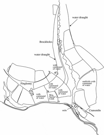
The definition of a croft appears to have undergone a transformation in the north east between its conventional medieval use and its eventual nineteenth-century definition. One aspect of the term which has remained virtually unaltered is the concept of it partially referring to an enclosed portion of land, separate from a share in an open field system. This feature underpinned its use as simply one part of the ‘toft and croft’ formula in the medieval period, through its subsequent use as the name for an enclosure as well as buildings, and, eventually, to its final usage referring to an enclosed area of land, dwelling and outbuildings and a share in communal grazing rights. At some time, it appears, the rights to a share in the open fields gave way to rights to a share in grazing. This development is important because, as the Royal Commission on the Ancient and Historical Monuments of Scotland point out (2007: 191), crofts do seem to have been a dynamic feature in the landscape and to have played a part in the intake of new land. This continued through to the nineteenth and even twentieth centuries. But to characterise crofts as a sixteenth-century invention for that purpose is to go against the evidence. William Taylor's croft at Finglennie (Figure 1) is clearly not associated with the intake of new land. The rentals of the Lordship of Huntly relate most of the service obligations to a formula which retains the holder of the croft at its heart: ‘half service as the fermorer pays, full service as the crofter pays’. This formula is unlikely to have been introduced in the early sixteenth century, when service dues were being widely commuted (Spalding Club, 1845), and is more likely to predate that time. The continued reference to crofts, with the attendant defining feature, the enclosed portion of land, which seems to have persisted from the twelfth century, suggests that the Earl of Strathmore's enclosures along with those of the other ‘improvers’ of a later period, were not necessarily innovative.
Estate plan of Finglennie (c.1776) showing ‘water draughts’ and irrigated fields (RHP2267).

Work undertaken on behalf of Forestry Commission Scotland in Aberdeenshire over the last five years has revealed an extensive array of pre-‘Improvement’ boundaries and buildings (Archaeology Scotland, 2007–2009: Volumes 8–10). They clearly predate the eighteenth century as they are not depicted on the estate plans from that time. Others which are depicted are defined as ‘old stances’ or ‘old dykes’. Relict field systems within the National Forest Estate have similarly shown that many of the fields depicted on the eighteenth-century estate plans were enclosed by substantial stone or feal dykes. Areas of meadow were grouped along with the cultivated rigs and all were enclosed. To see the enclosed fields of the Garbet as simply a late seventeenth-century expansion into former waste is to misread the evidence.
Another feature which has received little mention is the evidence for the use of water as a means of agricultural improvement. Estate plans containing the fermtouns of Craigwater, Glennieston and Finglennie (RHP 2266; 2248; 2267) in the Clashindarroch Forest area depict ‘water draughts’. A further probable example survives at Drumferg. Those at Finglennie are lades (or leats) running along the contour above an area of enclosed fields (see Figure 1). They were clearly designed to irrigate and possibly fertilise fields, much after the fashion of the catchworks of south-west England and Wales (Williamson, Reference Williamson, Cook and Williamson2007: 43; Cook and Williamson, Reference Cook, Williamson, Cook and Williamson2007: 56–60). Figure 1 shows fields notated as being in ‘command of water’. Their dating is unknown. Brockholes is listed along with Finglennie in the 1600 rental and a notation next to the name Brockholes on the plan runs: ‘improved much within 20 years’. Had the other fields been so recently improved, the one at Brockholes is unlikely to have been singled out. Presumably, therefore, the other enclosures and irrigation works date from before the 1740s. One of the surviving lades at Finglennie has been cut by an ‘Improvement’-period drystane dyke indicating that the lades were no longer being used at the time the dyke was constructed. As will be outlined below, such dramatic improvements to a local and traditional management regime seem to have been occurring in what is now the Clashindarroch Forest during the 1600s. On the other hand, it should be noted that the recently recognised mill and possible fish ponds at Corrylair, for which there is ambiguous evidence in a charter of 1511 (Paul, Reference Paul1984: 3599), also indicate that ‘water features’ applicable to an earlier period were falling out of use in the sixteenth century. No other reference to any of these features occurs, either in documents or on maps, and the present mill pond by the modern farm of Corrylair is more recent. In other words the ‘draughts’ may have been relict landscape features of an earlier time and not associated with an increased exploitation of land in the seventeenth century.
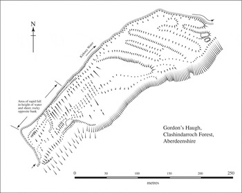
Figure 2 depicts an area of haugh-land (low-lying land in a river's floodplain) which appears to suggest use as a water-meadow of some kind. It does not seem to be a fully-fledged ‘bedwork’ system and, if its absence from the estate plans is taken into account, was completely abandoned by the first half of the eighteenth century. Much of the area has been damaged by heavy forestry machinery operating since the 1950s, but its position in an awkward corner has permitted better survival than might otherwise have been the case. Other related earthworks upon haughland are also now being recognised in other forests in the north east. Whether they reflect ‘upward-floating’ techniques, ‘flushing’ techniques or a combination of both requires further thought (Taylor, Reference Taylor, Cook and Williamson2007). Also to be noted is the ‘sump’ and apparently related platform next to it at the eastern end. This suggests some other purpose beyond simple irrigation. Similarly, the west end also appears to contain structural features which may or may not be associated with the use of the earthworks. However, the general layout suggests an area that was periodically flooded and drained. The appropriation of fertile silts from the river in spate might well have formed at least one reason for its manufacture with the added possibility of irrigation during the drier periods of the year in order to help fodder production. As will be seen below, this part of Strathbogie appears to have been one more commonly utilised for animal husbandry.
Haughland with earthworks resembling water-management features.

Discoveries such as these help to underline the point that the landscape components of the north east were more diverse than hitherto accepted and the means of exploitation more complicated. In a similar vein, conventional ‘head dykes’, as commonly found in more Highland regions, are only one of many forms of field system employed in Strathbogie (Shepherd, Reference Shepherd2007). To try to enforce a management regime applicable to the use of one field type across other types of field system without good evidence should not be countenanced. What I hope to show below is that many ecological sub-zones existed throughout Strathbogie, each with its own set of dynamics. They were, however, all interconnected through the wider structure of the estate. I am aware that this is introducing the spectre of a form of ‘multiple estate’ into a post-medieval environment. However, considering the persistence of a feudal hierarchy into this period, I see no social ambiguity within that notion. To present a picture of post-medieval agriculture in eastern Scotland as monocultural and never changing is to ignore a vast array of evidence to the contrary.
The evidence presented below is largely derived from rentals, although supported by field evidence. This demonstrates wide variations in fermtoun productivity, both in terms of rental value and the kinds of produce and can be shown to correlate with a variety of ecological zones. These correlated zones appear, in turn, to be related to recurring themes of settlement dispersal and nucleation. If this is, indeed, the case, cartographic and documentary evidence can be seen as a valid means of recognising typologically distinct sites which would benefit from further paleoecological sampling and targetted excavation. The study of the ecological development of the landscape can be enhanced by such an approach.
Background
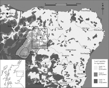
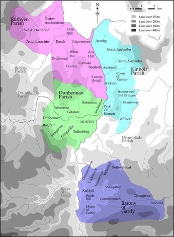
Strathbogie crosses the topographical divide between the arable lowlands of the north east and the rough grazing of the Grampian uplands (see Figure 3). At its north-eastern end, the landscape is characterised by gently undulating hills. This landscape gives way to steeper-sided valleys cutting into the north-east projections of the Grampian uplands. These valleys contain rich haughlands and some quite extensive areas of gently sloping and well-drained valley sides. The south-west corner of the Lordship is rough upland grazing, the Blackwater having been shieling grounds. The soils are predominantly of the Foudland drift series deriving from ‘slates, phylites and other weakly metamorphosed argillaceous rocks’. Those particularly prevalent in the area under discussion are characterised as ‘humus-iron podzols with some brown forest soils, gleys and peaty podzols’. Vegetation is characterised as ‘arable and permanent pastures; dry boreal heather moor and acid-bent fescue grassland’, dependent upon the varying altitudes and local terrain (Macaulay Institute, 1982). Figure 4 also shows the internal divisions of Strathbogie into its sixteenth-century parishes and regions. The map showing the land capability for agriculture is also a fairly representative view of the topography of the area, with the arable lands giving way to pasture and then rough pasture with increased altitude. The Buck, overlooking the Cabrach in the south west of the area, attains over 700 metres above Ordnance Datum with the river basin of the Cabrach being around 350 metres above Ordnance Datum. The river valleys in the north east of the area are around 100 metres above Ordnance Datum.
Map showing simplified land capability for agriculture gradings across the north east of Scotland. The main area detailed by the rentals is boxed.

Map showing topography, parish areas and fermtoun boundaries as depicted on various estate plans of the later 18th century.

Dodgshon notes how the character of many highland pre-clearance tounships might be likened to ‘lowland economies squeezed into upland ecologies’ (Reference Dodgshon, Whyte and Winchester2004: 68). He also notes that a set of circumstances will have arisen which required tounships to increase their reliance upon arable crops at the expense of livestock production in order to arrive at this point. This could have been either a community-based or a lordly decision (or a mixture of both), but the result would have been the same. In other words, change can be surmised from the records but any attendant physical impact is not always easy to demonstrate. However Chrystall and McCullagh (Reference Chrystall and McCullagh2000) have shown the multi-period nature of a relict landscape at Boyken Burn, Eskdalemuir. Banks and Atkinson (Reference Banks and Atkinson2000), in the same volume, have noted probable settlement ‘drift’, demonstrating that upstanding remains do not necessarily reflect earlier patterning. Therefore, much evidence exists to suggest that changes in agrarian strategies were not unusual in the centuries before the ‘Improvements’ and that such change might well have been related to physical changes in the landscape.
Pollock's work in the Lunan Valley (Reference Pollock1985) exemplifies many of the difficulties encountered in attempting to understand an extensive landscape with only very fragmentary field remains and a lack of useful early records. The Ben Lawers Project (Atkinson et al, Reference Atkinson, Syme Duncan, Lelong and MacGregor2003, Reference Atkinson2005) exemplifies what can be gained from a detailed study of an entire landscape rich in field remains and extensive documentary records, even though final results are still pending. Whilst its scope and approach should be applauded, it must be remembered that this landscape is only one of very many varieties present through time and across regions. The very obvious differences in topography, ecology and land-use typified by these two projects highlight just some of the distinctions that should be anticipated. Dodgshon notes the quite subtle variations which might occur between a stock-based, ‘bowhouse’ holding (the rent deriving from which was specifically related to dairy products) and contemporary arable holdings in the same district. These distinctions might only be apparent with recourse to documentary evidence (Dodgshon in Atkinson, Reference Atkinson2005: 7). Ross is correct to stress the increasing recognition of the benefits of targetted paleoecological sampling for understanding the ecological development of landscapes (Reference Ross2006: 213) and also notes, in the same paper, how a ‘one size fits all’ approach fails to satisfy. He uses the evidence supplied by the great variety of souming rates to exemplify this. Young's position (Reference Young2007) of seeing the Scottish landscape of the mid seventeenth century as a place made desolate by constant warfare and over-exploitation, whilst perhaps true for some locations, appears increasingly isolated and reactionary in the face of the emerging evidence.
The Murrays’ excavations at the deserted burgh site of Rattray (Reference Murray and Murray1993) exemplify another settlement type, this time fully placed in the medieval period, which is unlikely to be unique. Similarly, Carter's study of the development of Inverurie (Reference Carter1999) shows how one single, important magnate, in this case, David, Earl of Huntingdon, could have a lasting effect upon a substantial area of landscape. This effect is likely to have influenced subsequent developments. Further afield, but very apposite to the present study in its attempt to span the medieval to early modern period, is the paleobotanical research into ecosystems and land-use changes through time by Lagerås in Sweden (Reference Lagerås2007). That work demonstrates many of the dynamics involved in landscape development within an area of twentieth-century forestation superficially, at least, similar to many topographical situations in the north east and serves to underline Ross's call for increasing the use of paleoecological approaches (Reference Ross2006).
Other projects have collided with the problem of pre-modern agrarian practices through the study of discrete archaeological sites. Examples include Yeoman's work at Wardhouse (Reference Yeoman1998) and the excavations of early corn-drying kilns at Chapelton in the Lunan Valley (Pollock, Reference Pollock1985), Capo and Abercairny (Gibson, Reference Gibson1988), and Lhanbryde, Moray (Alexander, Reference Alexander1997). Such work demonstrates that early settlements were not always simply in situ forerunners of later sites and that, in order to understand early settlement patterns and ecosystems, it is important to be aware of the wide variety of possible forms and varying degrees of dispersal. Whilst many such sites are very interesting architecturally, their frequent isolation leaves in question the wider agrarian and settlement landscape of which they formed a part. By utilising the documentary and cartographic evidence alongside topographical and archaeological details, it is argued that subtle nuances pertaining to pre-modern settlements and their related ecosystems can be accessed. More intrusive research, including excavation and paleoecological sampling, would, however, be required to characterise more fully these changes through time which have resulted in the wide range of observed post-medieval strategies.
To understand the development of the Scottish rural landscape, therefore, study must be directed at the full range of settlement types and their related eco-systems, not just a select few. This study will add a further example of landscape utilisation to set against those from other areas and, in so doing, will help towards revealing a more complete picture of the undoubtedly vast range of agrarian practices and types of settlement distributions that have existed across Scotland.
The 1600 and 1610 rentals and differential agrarian strategies
Figure 4 shows the four areas forming the basis for this study: the parishes of Ruthven, Dunbennan, Kinnoir and the Barony of Gartly. Dunbennan and Kinnoir possess complete rentals from 1600, 1610, 1675 and 1760 and detailed estate plans from the 1760s and 1770s. They also possess shorter rentals from 1654. Ruthven has rentals from 1600, 1610 and 1675 and estate plans but lacks the rental from 1762. The Barony of Gartly possesses rentals from 1600, 1610 and 1760, along with estate plans, but is lacking the rental of 1675. The rental for 1723 supplies parish totals for money and grain rents. Even in the absence of one type of record each for Ruthven and the Barony of Gartly, it is considered that enough survives to piece together the land-use and settlement strategies of the area as a whole. Two other areas will also be drawn upon for evidence: the Braes of Gartly and the Parish of Drumdelgie. The Braes of Gartly, unfortunately, do not possess a complete set of good quality estate plans of the area, although the rental record is very good. Drumdelgie possesses some good plans but lacks the final rental. Both can, however, be called upon for corroborative evidence.
A limited section of the 1600 rental was partly transcribed by the Spalding Club and published in 1849. The first two rentals, from 1600 and 1610, cover the lands held by George Marquis of Huntly in Strathbogie and the Cabrach and are bound with others covering Mar, Enzie, Lochaber, Badenoch and Inverness as well as other smaller parcels in the north of Scotland. In all, the rentals run to some 204 extant pages, although some pages have been lost and others are badly damaged. The rents were paid in diverse ways, from money to a wide range of arable and animal produce. The scribal alterations in the text make it clear that these were not fossilised and customised forms but were being updated and renegotiated on a regular basis. This can also be seen from the substantial differences between these first two rentals which were separated by only ten years.
On the other hand, the rents, at times, possess a more formulaic and unchanging appearance, especially with respect to the payments in animals and, as noted above, with respect to service dues. Whereas the cash and grain payments seem to have been individually negotiated for each fermtoun, the animal payments appear consistent across a number of fermtouns in the same vicinity. This might suggest that these reflect a more customary payment which might relate to an earlier period. However, it should also be borne in mind that animals are less easily subdivided than are quantities of grain or cash! Although some peculiar portions of cattle, such as three-eighths and five-eighths at Bucharne, exist, they usually add up to a complete animal between the properties involved and can, because of this, give a clue to the nature of the subdivision of farming units. This example suggests that the original rent may have preceded the splitting of the unit.
One major problem arising from a rental which prescribes payment in a range of currencies is to develop some uniformity in order to be able to compare and contrast individual farming units. A rich source of comparanda is fortunately supplied by the Aberdeen fiars (Gibson and Smout) which cover the entire period of this study. These fiars give average wholesale (Young, Reference Young2007: 66) market prices for consumables from grain, meats, butter and cheese to a diverse range of other items which do not concern us here. Quite significant fluctuations in yield occurred from year to year, as would be expected in a pre-chemical fertiliser economy far more responsive to the vagaries of climate. By using these fiars, a calculation was made to convert the various animals and grain to a monetary value. The same process was also carried out for 1760 and an inflation figure of approximately 200%-300% was arrived at for the whole period. Inflation, as adduced from the fiars and the rentals, appears to have been fairly negligible from 1600 to 1675. After conversion of the various rents, the fermtouns could then be compared one to another with respect to the quantities of their individual production capacities as revealed by the rents. It has already been remarked how the rents appear to have been renegotiated very regularly and are, therefore, likely to reflect the contemporary productivity of the farm. That these were often issues of only minor negotiation is suggested by the amounts involved: for example, Affleck saw a reduction from eight to four bolls in part of its ferme whilst Mortlach's measure of oats went from one to two bolls. These were the only alterations in the rents for these fermtouns and accounted for very minor portions of the total rents.
A further, potentially complicating, matter is the issue of grassums, an amount additional to the rent, payable once in advance, and which covered the entire period of the lease. However, when broken down over the period of the lease and compared to the total rental value, the amounts are generally so small as to be quite negligible in terms of affecting total rental values. Exceptions include the case of the ‘marcatt of Rhynie’, where its grassum was rated the same as its rent; or cases when the value of a fermtoun was very low. For example, Cormalet paid a grassum equivalent to seventeen Scots pounds per plough per year and an annual rent of thirty Scots pounds. Although these occasional cases do not affect the larger picture discussed below, they provide useful additional evidence for how the landscape was ordered.
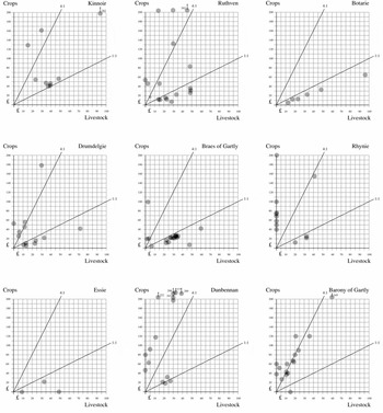
By converting the rental products to monetary equivalents, it is possible to view the relative proportions of arable and livestock produce for each fermtoun. This assumes that the rentals are based upon a fairly accurate reflection of the productive capacities of the various fermtouns. Were this not the case, such minor alterations to the rentals, as noted above, would probably not have occurred. The results can then be plotted graphically as demonstrated by Figure 5. All of the figures are available for the whole of Strathbogie and so have been included to underline the validity of the pattern. Unfortunately, even by the time of the 1675 rental, the habit of paying rents in kind was diminishing, especially as regards the livestock constituent, although the payment of rents in arable produce continued to the nineteenth century. In this respect, therefore, we have a better chance of understanding the agriculture of the late sixteenth and early seventeenth century in the area than we do that of the early eighteenth century.
Graphs depicting the values of rents paid in either arable or livestock products by fermtouns within different parishes in Strathbogie. Circles relate to individual fermtouns. Data derived from the rental of 1600.

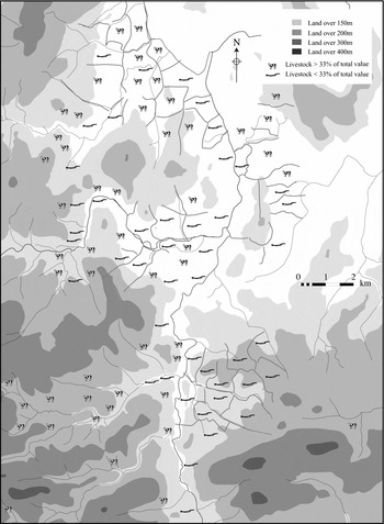
Figure 5 also suggests that two very distinct types of agrarian practice were coexisting. Firstly, there were those fermtouns specialising in arable production that were paying at least four times more in arable produce than they were in livestock produce. The second group were paying their rents in equal quantities of arable and livestock products, or livestock products were more prevalent than arable products. The large statistical void between these two groups is only breached by the livestock-producing contingent from Kinnoir, which seems to have produced rather more grain than other ‘livestock-based’ fermtouns in Strathbogie. What this appears to demonstrate is that the early seventeenth-century rentals suggest that two distinctive and mutually exclusive sets of fermtouns existed side-by-side in the parishes of Strathbogie. If these are plotted on a topographical map of the area (Figure 6), a possible cause for at least a part of this distinction becomes clear. The fermtouns producing mainly arable products are found predominantly on the lower-lying and flatter lands with better-drained soils. The livestock-producing fermtouns are predominantly found on the higher lands. That this is occurring is not in the least surprising. What is useful, however, is the demonstration that these results support the argument that the rentals do, indeed, contain significant information concerning land-use and agrarian practice. If the variations in kinds of rent were merely to be seen as arbitrary results pertaining to varying manners of extracting a surplus rather than being reflective of a genuinely different product-base, such topographical correlation is unlikely to be as significant as the evidence suggests. However, aberrations from the expected pattern do become more interesting and might signal a less ecologically-determined cause. In this respect, there is one interesting group of arable fermtouns lying on higher lands. This is the Barony of Gartly which will be discussed at greater length below.
Map showing differential land-use within fermtouns. A cow indicates those areas paying rent by means of livestock, a plough by payments of grain. Data derived from the rental of 1600.

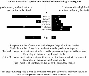
Another aspect of farming which might be discernible in the rentals is related to the different species of animal and relates to whether any connection might be seen between cattle, sheep and pigs and different agrarian practice. Figure 7 shows graphically different animal types compared with the dichotomy of ‘arable’ and ‘livestock’ fermtouns. On fermtouns producing a large part of the rent in livestock, sheep and cattle are almost equally likely to be the main constituent of the animal product in the rent. On ‘arable’ farms cattle are never the major constituent. On ‘livestock’ fermtouns pigs are rarely even the second most prominent animal, while on ‘arable’ fermtouns they are very common as the secondary animal.
Representation of differential land-use between various fermtouns. Data derived from the rental of 1600.

It is now possible to say not only that is there a pronounced dichotomy in agrarian production between fermtouns producing mainly arable products and those producing a mixed set of produce, but also that some of those ‘livestock’ fermtouns appear to have been specialising in cattle or cattle products whilst others appear to have been more focussed upon sheep and/or sheep products. Arable fermtouns appear to have had sheep as their livestock mainstay but, interestingly, to have had pigs as a secondary livestock attribute. Pigs, on the other hand, were of less importance on the livestock fermtouns. As many of the arable fermtouns were positioned along the riversides, it might be that pigs were kept to forage amongst the alder copses which were still evident in these locations on eighteenth-century estate plans, although the importance of pigs as a rich source of manure might well have been of at least equal significance. It is now time to turn to what can be observed of the changing fortunes of these fermtouns through the course of the following two centuries.
Agrarian dynamics through the seventeenth and eighteenth centuries
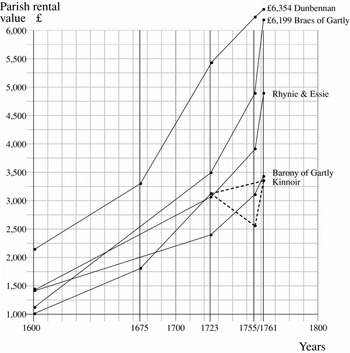
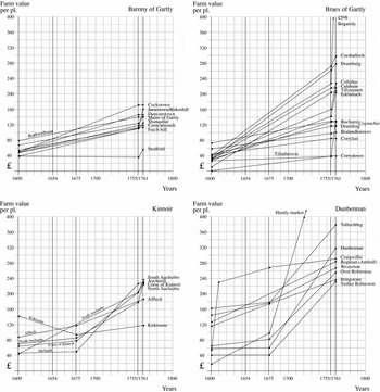
The rentals of 1600, 1610, 1675 and 1760 give us snapshots of the profitability of the Strathbogie fermtouns through this period. The 1723 rental, whilst lacking detail, at least gives an overall view of the individual parishes. Unfortunately, by this time, some parishes had been reorganised, making comparisons with some earlier sets of figures meaningless. Those reorganised parishes have been omitted from Figure 8. Some individual fermtouns (see Figure 9) demonstrate very little change in rents and seem to support the suggested inflation rate of around two hundred per cent proposed earlier, as derived from the Aberdeen fiars. Some show marked increases in rent and some distinct decreases. Both cases require explanation. Figure 8 depicts the rental rises per parish and Figure 9 shows the value of rents of the individual fermtouns expressed as an annual rent per plough. Different fermtouns were of different sizes and in order to compare them it is necessary to use a common denominator, in this case the ‘plough’. This was an inexact size system, theoretically approximating to about 104 acres or eight oxgates (Pirie, Reference Pirie1906: 16), but one that was seemingly acceptable to those involved in negotiating the rents of the individual fermtouns in the early seventeenth century. By the time of the 1760 rental, its shortcomings appear to have been becoming less sustainable and the smaller but still imprecise measure of the ‘oxgate’ (approximately thirteen acres in the north east) was used. Irrespective of ‘ploughs’ and ‘oxgates’, the fermtouns composed of a ‘plough’ in 1600 were still recognisably the same units 200 years later on the eve of the ‘Improvements’, although internal subdivisions and unions may have occurred. The assessment carried out in 1760 on the death of Henrietta Duchess of Gordon appears to have been used as a means of reassessing some lands which seem to have lagged behind the rent increases affecting most farms. This might explain the sudden jumps in the graphs between 1755 and 1761, when the new rents were to come into effect, although the possibility of exploitative rental rises is explored below. The dotted line for Kinnoir on Figure 8 suggests that some tenants were not being entirely honest and were claiming that what they had been paying in the past was rather lower than had in fact been the case! By ignoring the 1755 fall, the gradual rise from 1723 is more in keeping with the results from the surrounding parishes.
Graph demonstrating changing rental values of parishes within the study area. Data derived from the rentals of 1600, 1675, 1723 and 1760.

Graphs demonstrating changing rental values of fermtouns within the study area. Data derived from the rentals of 1600, 1675 and 1760.

The graph that seems easiest to understand is that relating to the Barony of Gartly. Most of the rises are between 200% and 300%. The Barony of Gartly, therefore, exhibits little evidence for dramatic change between the late 1590s and 1760. The same cannot be said about the Braes of Gartly, across the River Bogie from the Barony and, unfortunately, lacking a full range of high quality plans for the area. Rent rises here varied from around 200% to in excess of 1500% for Edendiack and Bogairdy! The Braes of Gartly seem to have been a livestock-dominated area in the seventeenth century but had become rich arable lands by the mid eighteenth century. It is possible that these rent rises were occasioned by this change in land use. It is unfortunate that there is no rental for 1675 for this area which might have permitted a clearer view of the period of this development. There is, however, also a lower-rented band of properties which did not see these huge rises and which are comparable to what was occurring in the Barony of Gartly. At Ruthven (not illustrated), we have the opposite problem in that the rental for 1675 exists but not one for 1760. Most fermtouns appear to demonstrate the same type of slight inflation observable for fermtouns in the poorer Gartly areas.
Dunbennan and Kinnoir give us the best insight into the dynamics of landscape changes in Strathbogie during this period. Out of the two, Kinnoir is probably the simpler picture. South Auchinbo appears to show a distinct increase from the first half of the seventeenth century. However, we lack a record for it in 1675 when it was ‘wodset’ (‘mortgaged’) and it is more likely that any change in landscape and rent occurred after this period; in which case it would have been similar to Auchmill in performance. Kirktoune shows a lessening in value whilst Auchmill shows the greatest increase. The two are probably related as it would appear that a number of arable fields which had been assessed under Kirktoune began to be assessed under Auchmill and stayed with that unit until the estate plan in the later eighteenth century. North Auchinbo saw a final increase of 318% and Corse of Kinnoir (Mekle Kinnoir) of 346%. Neither of these figures is excessive and both areas are unlikely to have seen much landscape development during the period.
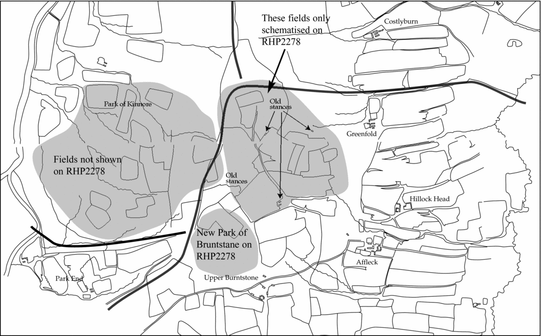
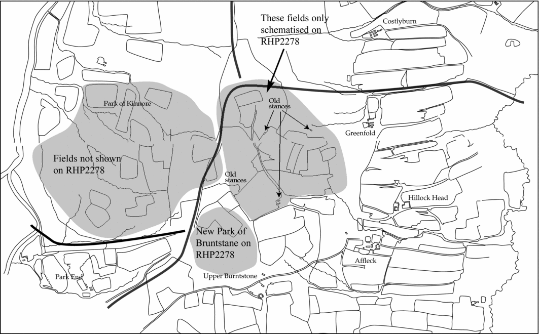
South Auchinbo and Auchmill saw greater rises of 515% and 487% respectively. The increase at Auchmill can be accounted for by its incorporation of some of Kirktoune's fields. That at South Auchinbo might be the result of taking in new fields, one located on the Muir of Auchinbo to the west and the other on its eastern boundary. Kirktoune's decline has been noted and the poor showing of Affleck might be as a result of an area reverting to ‘waste’. A set of fields and dwellings on the north-west part of that fermtoun, whilst depicted on the first draft of an estate plan (RHP2279), appear to have already gone out of use. The redraft (RHP2278) shows a schematised selection of these enclosures with no buildings and only one reference to ‘old stances’. The area of the ‘Park’ is devoid of fields with the exception of one small enclosure on this later draft. Figure 10 shows a combination of both plans, including the fields of the ‘Park’, along with the old stances, all of which had disappeared by the time of the later draft. The ‘Park’ is noted as forming part of the Mains and town of Huntly in the 1600 rental, presumably recalling its earlier affiliation with the Castle. The new, smaller park of Burntstone is shown overlying two of the fields on the later draft. The Affleck fields are now back under intense cultivation, but the fields of the park are now beneath Forestry Commission plantations.
Combination of 2 plans, RHP2278 and 2279, showing the areas of Affleck and the Park which had fallen into disuse by the time of the final draft (RHP2278).
Dunbennan parish exhibits the greatest changes in fortune. This is hardly surprising since it contains the developing market centre of Huntly. Huntly Market, the Marcatt of Rawes, saw an increase in value during this period of 3955%! Dunbennan also had the greatest spread of rental values at the beginning of the seventeenth century and, whilst this range persisted, there were changes in the relative values of the fermtouns. The Market had gone from the lowest valued item to the highest. Craigwillie saw a massive increase in rent of 482% between 1600 and 1675, but little thereafter. This might have been due to the intaking of low-lying land between its original crofts and the river Deveron and the development of its arable potential in place of, or to complement, its former livestock practices. Six new crofts appeared in the 1610 rental which were not noted in the rental of 1600 and the rent jumped from fifty-six pounds to £224 at that time. Similarly, the livestock fermtoun of Dunbennan increased massively in value after 1675. Presumably, this was as a result of utilising its rich riverside haugh lands for cereal production. However, most of the rental increases occurred after 1675. Interestingly, most stagnation took place in three of the previously dominant arable farms: Bogtoun, Westerton and Ittingstone. These three might also be characterised as having little land over which to expand and, consequently, their values barely kept up with inflation at 222%, 164% and 202% respectively.
The study of rental dynamics over the period, therefore, demonstrates a mixture of successes and failings. There were many areas of new intakes, both infield and outfield, whilst, at the same time, some fields were apparently going out of cultivation, presumably owing to over-exploitation. Some fermtouns, such as those in the Barony of Gartly, appear to show a controlled maintenance of value. However, further questions are raised by the foregoing appraisal: why were the haugh lands of settlements such as Dunbennan under-utilised at the beginning of the seventeenth century? The answer is beyond the parameters of this paper and probably pertains to earlier variations in land-use. These areas represent lands formerly utilised but neglected by that time. This might explain why Dunbennan and Bogtoun had the same theoretical assessment of one ploughgate apiece, despite having actual rental values of vastly disproportionate amounts.
Whyte has drawn attention to a similar distinction between the lower rental increases of low-lying lands and the higher rates of neighbouring farms in central Scotland (Whyte, Reference Whyte1979: 207). This seems to be a result of liming within an area that was moving into a more capitalist approach to farming. It is uncertain how far the use of lime encouraged the rental rises in the Braes of Gartly. Lime formed part of the rent in Botary parish from at least as far back as 1600 and a disused limestone quarry was noted at the north end of the Braes on an estate plan of the 1760s. But, the farming pattern remained fundamentally traditional in terms of leases, rents, field layout and settlement form. There was nothing to define this area as being ‘Improved’ in terms of moving towards agricultural production based upon capitalist principles.
It is probably pertinent to consider the local political and religious history of the area in order to attempt to contextualise these rental dynamics and to determine whether they can be seen as simply a product of increased lordly exploitation. The seventeenth and eighteenth centuries saw four important organisational changes that could have affected the area. The period from 1600 to 1653 was simply a continuation of the Gordon lordship that had persisted since the fourteenth century. The rents, when compared with others from the area contained within the diocesan records for the earlier sixteenth century (Spalding Club, 1845), show a general similarity in content and value. The monetary payments (maill) and the livestock rents show little sign of increase. The customary grain payments are noticeably higher in the Huntly rental of 1600, but the additional monetary payments in place of service on the diocesan lands are missing from the Huntly rental. A comparison of these sets of rentals would, therefore, suggest an increase in grain rentals but nothing else. Increased exploitation is likely to be reflected across the range of rents, especially the monetary portions. The evidence would, therefore, fit with an increase in available arable land leading to an increase in grain payments.
From 1653, the Lordship of Huntly was granted by ‘the Keepers’ during the interregnum to Alexander Ferquhar and John Lyon (Paul, Reference Paul1984: 101; 216). This change of hands seems to have led to the somewhat scruffily-compiled rental assessment of 1654. This might have seemed an opportune moment for a bit of ‘asset-stripping’, but this does not appear to have materialised and the rents reflect those of the 1600 and 1610 rentals. This interlude was reasonably brief and the Fourth Marquis of Gordon received his lands back upon the Restoration. The 1675 rental is, therefore, well-placed to illustrate this new period of lordship, but unfortunately not all fermtouns are included in this document. The ones that are show a general and gradual inflation across most units, with a couple of dramatic increases and a couple of noticeable decreases. This is not the picture which would be produced by a regime of ‘rack-renting’ and attempts to over-exploit, which would generate a more universal rise in rents. The next period to 1723 also sees similar rises in rents across the parishes as a whole although, unfortunately, this rental gives no breakdown of individual fermtouns (Figure 8). As the rises seem to maintain gradients not unlike those which preceded them, it is unlikely that such a change reflects over-exploitation, although this cannot be said with absolute confidence.
Thereafter, the world changed for the Gordons and the north east as a whole. Up until 1745 and Culloden, the north east had not fully embraced the Reformation world. The ‘National’ Covenant was hardly that. Aberdeen had refused to sign in 1638, for which act its period of commercial expansion was cut short (MacNiven, Reference MacNiven and Stevenson1986: 63). The Presbytery Book of Strathbogie is full of refusals of parishioners, both lordly and poor, to sign. James Gordon read the Covenant at Dunbennan in 1643 and ‘all in one voice refused’. Alexander Fraser ‘had gotten no subscriptions’; Robert Watson ‘had gotten some hands’; William Reid ‘had gotten no subscriptions save his own’; and the list continues (Presbytery Book of Strathbogie, 29th November 1632). Even in the 1650s ‘mopping-up’ operations were still concerned with forcing signatures from people such as James Gordon of Daach (ibid., 25th September 1650). And as late as 1713 the inhabitants of Turriff barricaded the church against the imposition of an incoming presbyterian minister, resulting in a riot and shots being fired. Illegal Catholic meeting houses persisted throughout the area until the Catholic faith was once again restored to delicate society in the nineteenth century.
Society was essentially feudal during much of the seventeenth century, with bonds of ‘manrent’ subinfeudating lesser to greater lairds. As an example, one drawn up between the Laird of Balquhine and George Marquis of Huntly in 1603 runs: ‘I bynd and obleiss me to be leill, trew, efauld, and faithfull man and servant to my said lord marques . . . . . contrair and aganis all leiff and, the Kings grace and authoritie only except.’ (Spalding Club, 1849: 255). In reality, such ‘manrent’ was a simple oath of fealty to a feudal lord, excepting only the King's superior authority. Such duty related to the requirement to turn out for military service (Whyte, Reference Whyte, Whittington and Whyte1983: 121). However, post-Culloden, the feudal world of the north east was forced to change and embrace a new real politik. Power had less to do with putting retainers into the field of battle and more to do with wealth and political manipulation. Gordon Castle in Fochabers was built in the 1660s as a replacement for the old Huntly Castle, which was slighted by war in the 1590s. It was built close to the small town of Fochabers. When Alexander the Fourth Duke of Gordon inherited the estate in 1752, a new broom decided ‘to sweep clean’. The town was moved on account of its ‘inconvenient nearness to Gordon Castle’, and, whilst removal expenses were paid, these seldom covered the costs of another dwelling (Slater, Reference Slater, Parry and Slater1980: 241). Similarly, Huntly Lodge was built in the 1750s as a country house on the site of a commercially-profitable fermtoun that was cleared for the purpose. And here we see the link with Young's Earl of Strathmore (Reference Young2007). Although much might be spoken of ‘Improvement’ by the landholders, their deeds frequently tell another story (Gregory, Reference Gregory2005). It is probably to this post-Culloden, ‘enlightenment’ period that the exploitation of the people and the land became more apparent in Strathbogie.
It may be no coincidence that the Gordons chose this period to make a pragmatic break with Catholicism. A son of the Duke, George Gordon, went on to foment the violent anti-Catholic ‘Gordon riots’ in London in the early nineteenth century (Scott, Reference Scott1997: 69). Figures 8 and 9 show that it was the rent review on the death of the Dowager Duchess in the 1760s that saw the most consistent and sweeping increases in rent throughout the Lordship. The earlier rentals depict a far less uniform pattern, and one more likely to reflect actual variations on the ground. The gradual increases between 1600 and 1750 for many fermtouns sit uncomfortably beside some which show very dramatic increases. Such a pattern is unlikely to reflect the exploitation more apparent in the more widespread rental increases visible in the reassessment of 1760. It might also be no coincidence that the exploitation increased on the death of a member of an earlier generation who might, arguably, have held more paternalistic views. It is obvious that the Fourth Duke had no such qualms. When he died, his legacy included an array of stately mansions, at least nine illegitimate children and vast debts which had to be paid for by the selling of huge tracts of land (Scott, Reference Scott1997: 106).
Settlement characterisation in the seventeenth and eighteenth centuries
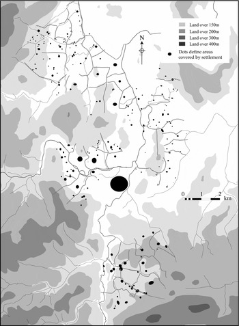
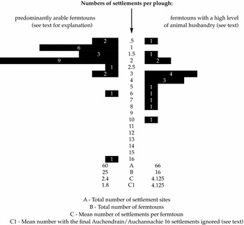
Figure 11 records all the settlements shown on the eighteenth-century estate plans of the primary areas under discussion. It is immediately obvious that some fermtouns contained a limited number of settlement foci, with each ‘focal point’ consisting of one or more farmstead units, whilst others possessed a greater number. If this map is combined with the map of differential land use (Figure 6) and plotted graphically, Figure 12 is the result. This seems to demonstrate that fermtouns involved predominantly with livestock ventures possessed a far larger number of dispersed settlement focii compared with the more nucleated picture seen in the case of fermtouns apparently specialising in crop production. The ratio is more than double if the ambiguous case of Over Auchendrain, with sixteen settlement focii, is withdrawn. This large fermtoun seemed to possess the two distinct régimes within the same agrarian unit. The lower lying land to the east of the fermtoun was nucleated amongst a suggested ‘planned’ axial arable field system of probable twelfth- to thirteenth-century date (see Shepherd, Reference Shepherd2007), whilst a more dispersed series of settlements were attached to the lower slopes of the Balloch where, arguably, a more livestock-oriented agrarian system was being practised. On the other hand, those dispersed settlement focii amongst the lower slopes of the Balloch, in the north-west corner of Figure 11, might have formed a part of the holdings of Auchanachie. This was a noted ‘livestock’ toun in the 1600s and was recorded as having ten ‘grassmens’ holdings in the 1696 Poll Tax returns. A ‘grassman’ usually received grazing rights rather than rights to a share of arable and so, by definition, was more closely associated with areas of livestock management. This situation would further skew Figure 11 towards emphasising a correlation between dispersed settlement and animal husbandry.
Map showing settlements within fermtoun groupings. Data derived from various 18th century estate plans.

Graph showing differential settlement patterning with respect to varying fermtoun land use. Data derived from various 18th century estate plans and rental of 1600.

It should be noted, however, that the recorded settlement pattern is derived from the eighteenth century whilst the conclusions relating to agrarian practice are based largely upon the rental of 1600, at least 150 years earlier, although supported by the evidence of the 1675 rental. This is an inevitable consequence of the limitations inherent in the evidence. However, the documentary rental evidence, especially from the Barony of Gartly, suggests that we should not presuppose change without accompanying evidence. Bogtoun, for example, was held by five tenants in 1610 with specified but unequal holdings. The estate plan of the 1760s depicts the toun as still held by five ‘crofters’ with similarly unequal holdings. Most of the settlements which demonstrate exceptional rental increases, such as Dunbennan, seem to do so as a result of more recent development of their lands for arable production, the settlement pattern apparently remaining unaltered from its livestock-producing, dispersed form. The settlement pattern may therefore be seen as a function of its accompanying field system pattern. Beyond the immediate study area, Tillyminate records a large rental increase and its field patterns suggest a large-scale replanning. It also displays a nucleated pattern of settlement which is, arguably, a consequence of those changes. Certainly, arable specialisation was more labour-intensive and might be expected to contribute towards a tendency to nucleation, but only excavation of such settlements could determine this unequivocally. Dodgshon has persuasively argued (Reference Dodgshon1993) that settlement nucleation might be related to a restructuring of field systems and agrarian practice and that earlier settlement forms might have been based upon a dispersed pattern. The findings of this study appear to lend weight to these suggestions.
Conclusion
This study appears to demonstrate three important features of landscape development in north-east Scotland during the seventeenth and eighteenth centuries. These occurred as a result of developing traditional strategies rather than employing the ‘capitalistic’ approach favoured by the ‘Improvers’. Firstly, three distinct agrarian strategies were being employed, at least at the beginning of the seventeenth century: (i) predominantly arable production; (ii) livestock farming with an emphasis on cattle; (iii) livestock farming with an emphasis on sheep. Secondly, that individual fermtouns were frequently undergoing dramatic changes in their fortunes, often positively, sometimes negatively. However, some fermtouns, such as in the Barony of Gartly, demonstrate little fundamental variation in production capacity through the period. Thirdly, these distinctive agrarian strategies appear to be correlated with differential patterns of settlement. Those involved in predominantly arable strategies exhibit a greater tendency towards nucleation, whilst those involved in livestock production, show a greater propensity to dispersal. What is also clear is that, throughout this period, the trend appears to have been away from the traditional reliance upon mixed farming strategies, as noted in the early sixteenth-century records, towards an apparent obsession with grain production.
This can only have compromised sustainability. Even the introduction of a degree of ‘ley’ farming was merely a short-term fix for the nitrogen losses incurred by the ploughing of permanent pasture and the resultant few years of bumper crops. Such results enabled the ‘Improvers’ theoretically to support suspect practices. Furthermore, it must not be forgotten that the ‘Improvers’ of the later eighteenth century were enjoying a period of improving climate and were comparing their results with predecessors who were forced to contend with the disastrous temperatures of the ‘little ice age’ (Tyson, Reference Tyson and Stevenson1986: 34). Even so, the long-term extent of agricultural land was altered little by the ‘Improvers’ of the later eighteenth and nineteenth centuries in the north east. Most intakes have long since reverted to ‘waste’. Allen has demonstrated that, in England, the ‘Improvers’ ultimately engineered profits by reorganising the land along lines suitable for a forced reduction in labour (Allen, Reference Allen, Campbell and Overton1991: 249). It is hard to view the Strathbogie evidence any differently.
The notion of an homogenised post-medieval/pre-‘Improvement’ settlement type, with its ubiquitous ‘infield/outfield’ agricultural pattern, must contend with a revised image of different agrarian regimes and resultant land use patterns, each with its own set of distinctive settlement and habitation characteristics. We must, once and for all, dispense with the notion of a ‘backward’ pre-‘Improvement’ agricultural regime in Scotland. Different it might have been and less appropriate to a new social milieu in which wealth was founded upon capital rather than numbers of fighting retainers. But, as Allen has shown in comparisons of pre- and post-‘Improvement’ field systems in the English Midlands, the notion that enclosure and larger farming units automatically led to greater yields is erroneous (ibid.: 242–50). Agriculture before ‘Improvement’ did not necessarily perform worse than that after, and, in the context of its different social system, might be considered to have been ‘better’. It probably supported a larger rural population within a number of more flexible systems appropriate to topographically diverse pre-fertiliser agronomies. Agricultural expansion on the Marquis of Huntly/Duke of Gordon's lands in the north east during the seventeenth and early eighteenth century occurred as a result of the expansion and development of a native agricultural system which does not appear to have ever been internally perceived as ‘Improving’. This expansion occurred to fulfil the requirements of a different social order, which had retainers rather than capital at its core. The ‘wilderness’ garden of Gordon Castle, recently discovered in Forestry Commission plantations, apparently similar to and contemporary with that depicted at Somerleyton Hall, Suffolk (Williamson, Reference Williamson2000: 17), attests an outward-looking landowner aware of, and articulating with, broader European culture. The perpetuation of a local system of agriculture will not have been as a result of ignorance or an unwillingness to change. Traditional Scottish agriculture was developing. However, this development was overtaken by a social reorganisation which saw many of those developments utilised and adapted to suit a new economic ideology based upon rationalisation and capital and underpinned by Enlightenment values of ‘Improvements’.
Documentary study of rental dynamics and variations in production strategies through time can help to pin-point different types of ecological sub-zones and the associated settlements of a multi-facetted pre-‘Improvement’ society. Survivals of some of these settlement types are still extant on the ground and more are still coming to light. It is to be hoped that targeted research, and, more particularly, excavation and a greater emphasis on paleoecological sampling as at Ben Lawers (Atkinson et al, Reference Atkinson, Syme Duncan, Lelong and MacGregor2003, Reference Atkinson2005), will fill out this sketchy picture before too many of these remaining traces are permitted to lose their present integrity.
Sources
Records held in the National Archives of Scotland, Edinburgh:

Estate Plans held in the National Archives of Scotland, Edinburgh:

Acknowledgements
I would like to express extreme gratitude to Ian Whyte for taking the time and trouble to comment upon this paper. He made many incisive and important comments which have been incorporated. Any errors and lapses of judgement are mine alone, for which I am content to take full credit! I would also like to thank Tom Williamson whose constructive comments forced me to focus more appropriately on what I was trying to say. Thanks must also go to the Moray and Aberdeenshire Conservancy of Forestry Commission Scotland for supporting much important field survey. This has resulted in the recording and protection of hundreds of sites which would otherwise have disappeared without a trace. Particular thanks to Ewan Reid for initiating the project and to Philippa Murphy and Jackie Cumberbirch in the conservation department for help and support beyond the call of duty.