Introduction
More than half of the world's population today relies on rice as its main staple food, and the expansion of rice farming has had a major impact on Asian environments. The trajectories from wild to cultivated to domesticated rice, and the development of more intensive arable systems, provided a basis for the development of social complexity in China, mainland Southeast Asia and parts of India (Glover & Higham Reference Glover, Higham and Harris1996; Fuller & Qin Reference Fuller and Qin2009, Reference Fuller and Qin2010). The spread of wet rice agriculture has also been linked to methane expansion and global warming (Ruddiman et al. Reference Ruddiman, Guo, Zhou, Wu and Yu2008; Fuller et al. Reference Fuller, van Etten, Manning, Castillo, Kingwell Banham, Weisskopf, Qin, Sato and Hijmans2011; Ruddiman Reference Ruddiman2013). Distinguishing between wet- and dry-farmed rice in archaeological contexts is key to understanding developing rice systems and their role in both socioeconomic change and environmental impacts. One method of determining changes in arable systems is to analyse ecological community groupings in the weed assemblages, an approach that has long been applied in Europe (e.g. Jones Reference Jones1992; Charles et al. Reference Charles, Hoppé, Jones, Bogaard and Hodgson2003). More recently, it has been extended to rice cultivation (Fuller & Qin Reference Fuller and Qin2009; Weisskopf et al. Reference Weisskopf, Harvey, Kingwell-Banham, Kajale, Mohanty and Fuller2014). In this paper, we present a new analytical method and illustrate its application to a chronological series of three sites from the Lower Yangtze region of China.
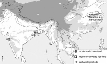
Our analysis uses differing ratios of phytolith morphotypes that are divided into those that are genetically predisposed to produce silica bodies in grasses (fixed) and those morphotypes that are formed only when there is sufficient uptake of water (sensitive). Madella et al. Reference Madella, Jones, Echlin, Powers-Jones and Moore(2009) developed this approach, using ratios of short to long cell phytoliths from the leaves of grasses of the Triticaceae family, to understand winter cereal irrigation (of wheat or barley) in arid zones in the Near East. Jenkins et al. Reference Jenkins, Jamjoum, Al Nuimat, Black and Mithen(2010) expanded the approach, also using Triticaceae, with experimental work in Jordan to interpret Near Eastern water management. Here, this model is taken a step further. Using ratios of fixed and sensitive cells from all available Poaceae in the phytolith assemblages, it is applied to ethnographic rice-field samples from India, and to three Chinese archaeological sites that document a sequence of change from c. 5000 BC to 2300 BC (Figure 1).
Map of archaeological sites in China sampled for this study and modern analogue sites in India.

Methodology
The phytoliths were extracted from sediment samples collected from early rice-cultivating sites (Table S1). The samples include both typical settlement waste and some palaeosols from areas of rice cultivation. First it was determined that the phytolith samples contained substantial proportions of rice (between 6900 rice phytoliths per gram and 6000000 rice phytoliths per gram). It was assumed that a substantial contribution of the phytoliths come from rice fields, including waste from processing the rice crop and weeds co-harvested with the rice. The use of phytolith assemblages to identify rice crop-processing has been demonstrated elsewhere (Harvey & Fuller Reference Harvey and Fuller2005; Zheng et al. Reference Zheng, Sun, Qin, Li, Wu and Chen2009; Weisskopf Reference Weisskopf2014; Weisskopf et al. Reference Weisskopf, Harvey, Kingwell-Banham, Kajale, Mohanty and Fuller2014). Each of the three sites considered here has also had macro-botanical analyses of archaeological flotation samples that indicate the prominence or dominance of rice in subsistence (Fuller & Qin Reference Fuller and Qin2010; Fuller & Weisskopf Reference Fuller and Weisskopf2012; Gao Reference Gao2012). Thus, the presence of rice cultivation was taken as a certainty and the focus was instead on assessing the wetter or drier ecology of rice and associated grasses.
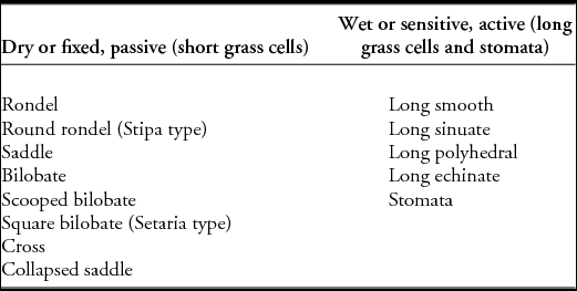
Samples were processed and counted following standard procedures for phytolith analysis. For this study, phytoliths were extracted from 800mg of sediment per sample following the protocol of Rosen (Reference Rosen, Pike and Gitin1999). Between 300 and 400 single cells were counted at 400× magnification for each slide. Counts were then grouped for morphotypes based on whether these were defined as sensitive or fixed cell types following the definitions of Madella et al. (Reference Madella, Jones, Echlin, Powers-Jones and Moore2009) (Table 1).
Phytolith morphotypes from grasses classified into fixed and sensitive morphotypes.

Phytolith production and the sensitive-vs-fixed model
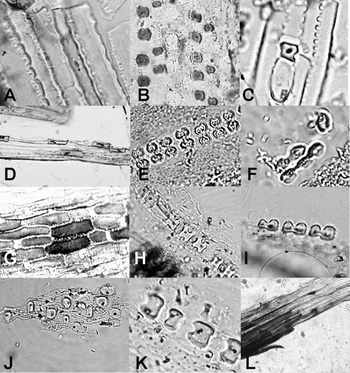
Phytoliths are bio-mineralised particles formed within the intra and extra-cellular space of living cells in the culms, leaves, roots and inflorescences of higher plants (Figure 2). Silica is an abundant element and a constituent of many mineral soils (Hodson & Evans Reference Hodson and Evans1995; Prychid et al. Reference Prychid, Rudall and Gregory2004). Soluble silica is released into sediments and soils by the weathering of silicate minerals (Piperno Reference Piperno1988; Prychid et al. Reference Prychid, Rudall and Gregory2004). Monosilicic acid (H4SiO4) is soluble in water and is absorbed into the plant with other minerals in the groundwater through the roots and carried in the xylem sap (Hodson & Evans Reference Hodson and Evans1995; Prychid et al. Reference Prychid, Rudall and Gregory2004; Piperno Reference Piperno2006). As the monosilicic acid is transported in the transpiration stream it moves through the permeable plant membranes, becoming polymerised as solid amorphous silicon dioxide (SiO2) in the plant tissues where it is deposited within the cell lumen and intercellular spaces, often taking on their form, as well as forming external layers on the cell walls (Piperno Reference Piperno2006). Silica may be found in all plant parts, including the roots, but most of it is laid down in the aerial structures, both vegetative and reproductive (Prychid et al. Reference Prychid, Rudall and Gregory2004; Piperno Reference Piperno2006). In grasses most phytoliths are commonly found in the epidermis. Among these many mechanisms affecting phytolith formation are two principal factors: genetically and environmentally controlled silicification. The first originates in the plant's own genetic and physiological mechanisms and relates to phytolith production in designated cells and tissues. Some cells actively accumulate silica and will produce phytoliths under any hydrological conditions (Hodson et al. Reference Hodson, White, Mead and Broadley2005; Madella et al. Reference Madella, Jones, Echlin, Powers-Jones and Moore2009). The second is associated with external factors of the local environment, including climate, soil type, soil hydration, age and type of plant (Piperno Reference Piperno2006; Madella et al. Reference Madella, Jones, Echlin, Powers-Jones and Moore2009.
Example of phytolith morphotypes included in this study, from modern reference material: A) Avena leaf long sinuate; B) Chloris virgata leaf saddles; C) Setaria faberii leaf square bilobate; D) Bromus catharticus leaves long smooth and rondels; E) Oryza rufipogon leaf scooped bilobes; F) wild Setaria sp. leaf bilobate; G) Panicum miliceum leaf long cells and bilobes; H) Coix lachrymajobi leaf crosses; I) Ischaemum rugosum leaf bilobes; J) Stipa tirsa leaf round rondels; K) Bambusa sp. leaf collapsed saddles; L) Dactylis glomerata leaf long smooth.

Grasses have high rates of production of silica bodies (phytoliths) both in and between the cell walls (Metcalfe Reference Metcalfe1960; Piperno Reference Piperno2006; Madella et al. Reference Madella, Jones, Echlin, Powers-Jones and Moore2009). There is variation between silicification in specific cells in different parts of the plant (Perry et al. Reference Perry, Mann and Williams1984; Webb & Longstaffe Reference Webb and Longstaffe2002). More importantly for the purposes of this study, there is variation according to the environment where the plant is grown (Epstein Reference Epstein1999; Tsartsidou et al. Reference Tsartsidou, Lev-Yadun, Albert, Miller-Rosen, Efstratiou and Weiner2007). Blackman and Parry (Reference Blackman and Parry1968) suggest short cells have genetic control over silica deposition in their lumen and so produce silica bodies regardless of water availability. Other cells, such as epidermal long cells, have no genetic control so silica deposition is influenced by external factors such as local environment and water availability (Blackman & Parry Reference Blackman and Parry1968; Piperno Reference Piperno1988). Greater transpiration through the plant can mean more silica deposited in cells that are not designed for this purpose. Looking at these cells is particularly appropriate for understanding rice agriculture. As wild rice is a wetland plant growing in warm marshy areas, high transpiration should be expected. When people started cultivating rice it is likely that they husbanded wild rice stands at lake and river edges, as reconstructed at Tianluoshan (Fuller & Qin Reference Fuller and Qin2010; Fuller et al. Reference Fuller, van Etten, Manning, Castillo, Kingwell Banham, Weisskopf, Qin, Sato and Hijmans2011). Once rice farming in small fields developed, however, as at Caoxieshan (4000–3800 BC), the fields may have been drier than the wild and early cultivated rice stands, as early fields were spread across the plains rather than just immediately along rivers. After the development of paddy fields with irrigation systems, we would expect to see a return to higher ratios of phytoliths from environmentally controlled silicification. There are several potential issues however; one is that rice generally grows in much more humid conditions than the south-west Asian winter cereals previously considered (Madella et al. Reference Madella, Jones, Echlin, Powers-Jones and Moore2009; Jenkins et al. Reference Jenkins, Jamjoum, Al Nuimat, Black and Mithen2010). More water and greater evapotranspiration are likely to cause higher phytolith production overall. This means that the grasses in the rice fields may produce too many environmentally sensitive morphotypes to make definable changes in arable systems (Table 1). We demonstrate that this is not the case and our results show the applicability of this method outside arid and semi-arid regions. Another potential problem is that while the model may be applicable to phytolith assemblages collected from sediments from specific fields, the phytoliths from the archaeological samples analysed here derive from a variety of contexts and have been deposited mostly as part of crop-processing activities. This may skew the results somewhat. The crop-processing residues should, however, reflect the plants in the field system from which they were harvested, and this is suggested by patterns in previous analyses (Weisskopf Reference Weisskopf2014; Weisskopf et al. Reference Weisskopf, Harvey, Kingwell-Banham, Kajale, Mohanty and Fuller2014). It should also be noted that the modern fields are in India while the archaeological samples come from the Lower Yangtze Valley in China, so biogeographic factors may affect the comparison of modern and ancient samples. Nonetheless, the responses of plant physiology to local environmental conditions, such as silica deposition in relation to water availability, are expected to outweigh biogeography. The modern fields we sampled in China were not useful for analysis because they produced few weeds or phytoliths, which we attribute to their treatment with herbicides. Nevertheless, we find interpretable contrasts in both ancient and modern samples that reflect the relative wetness of fields.
The modern rice fields
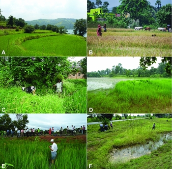
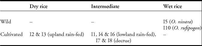
Sediment samples for phytoliths were collected from traditionally farmed modern rice fields in the Western Ghats and Orissa, India, in order to create modern analogues to test the archaeological samples (Fuller & Weisskopf Reference Fuller and Weisskopf2012; Weisskopf et al. Reference Weisskopf, Harvey, Kingwell-Banham, Kajale, Mohanty and Fuller2014). The fields represented a range of arable types: lowland rain-fed, upland rain-fed and decrue, as well as wild rice (Figure 3). Wild rice was further divided into perennial (O.rufipogon) and annual (O.nivara). Soil samples were processed for phytoliths as a representation of the diversity of weed flora. For the purposes of the present study, these analogue fields were grouped, based on the broad variation of soil moisture level inferred throughout the growing season, as: a) dry (rain-fed and margin of wetlands); b) very wet (in standing water throughout most of the growing season, as typical of either deep water rices, irrigated paddies or wild rices); or c) intermediate (Table 2).
Examples of modern rice stands in India sampled for phytoliths in this study: A) upland rain-fed rice, Penchant Ghat, Maharashtra (I2); B) lowland rain-fed rice, central Odisha (I4); C) lowland rain-fed rice, Maharashtra (I1); D) decrue field in Munda zone of northern Odisha, ranging from dry to deep water (I7); E) Oryza rufipogon, perennial wild rice, north-east Odisha (I10); F) Oryza nivara, annual wild rice, north-east Odisha (I5).

Modern rice stands in India sampled for phytoliths and grouped via relative degrees of wetness (further details of sites in Weisskopf et al. Reference Weisskopf, Harvey, Kingwell-Banham, Kajale, Mohanty and Fuller2014).

The archaeological rice and weeds
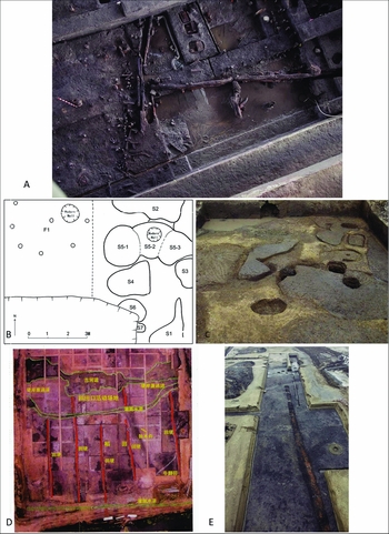
The archaeological samples come from three Neolithic sites in the Lower Yangtze: Tianluoshan (4800–4300 BC), Caoxieshan (3950–3700 BC) and Maoshan (3000–2300 BC) (Figure 4). Tianluoshan (Figure 4a), in Zhejiang province, is a Neolithic Hemudu culture site with evidence for pre-domestication rice cultivation; the site shows an increasing proportion of morphologically domesticated rice over time, as well as an increase in rice as a proportion of all foods (Fuller et al. Reference Fuller, Qin, Zheng, Zhao, Chen, Hosoya and Sun2009). Excavations between 2004 and 2007 by the Zhejiang Province Institute of Archaeology have produced important archaeobotanical and dating evidence on the Hemudu culture (Sun Reference Sun and Underhill2013). Direct AMS radiocarbon dates on nuts and grains show a sequence between 6900 and 6300 years BP covering four distinct phases: K3 midden; layers 8 and 7; layers 6 and 5; and layers 4 and 3 (Fuller et al. Reference Fuller, Qin, Zheng, Zhao, Chen, Hosoya and Sun2009). The 14 phytolith samples analysed here are from the second (layers 8–7) and third (layers 6–5) phase as well as a later fourth phase (layers 4–3). All samples are from cultural contexts within the settlement area, although in layer 8 these are at the edge of a stream that the settlement abuts, while the others are from within and around areas of buildings (houses), indicated by preserved wooden posts. The data from the macro-remains suggest a growing dependence on rice over time (Fuller et al. Reference Fuller, Qin, Zheng, Zhao, Chen, Hosoya and Sun2009; Fuller & Qin Reference Fuller and Qin2010). The phytolith samples from the ancient river's edge, and those from the cultural contexts, yielded rice remains suggesting an important input into the phytolith assemblage from rice cultivation and rice processing.
The archaeological sites sampled for this study: A) Tianluoshan Site, main part of ancient river (centre) and western river bank, with posts aligned along the bank (left); B) Caoxieshan site, plan of trench T0422 plan (F1: house platform with postholes; S: paddy fields); C) Caoxieshan site trench during excavations showing paddyfield units (trench is 5m wide); D) Maoshan site, overview of whole paddy area (orange lines drawn over paths/embankments between paddy fields; archaeological trenches are 15m2; E) part of Maoshan excavations showing a view of pathway L2, the eastern-most field boundary uncovered, running north–south.

Caoxieshan, in Jiangsu province (4000–3800 BC), is a later Lower Yangtze site. Excavations in the 1990s revealed small shallow fields often 0.2–0.5m deep, all less than 10m2 in extent (Zou et al. Reference Zou, Gu, Li, Tang, Ding, Yao, Yan and Yasuda2000). More recently in 2008, these fields together with associated cultural layers and a house-related midden were sampled for flotation and phytoliths (Figures 4b & c). Our working hypothesis is that these fields functioned to allow tight control of water and especially the draining of water to drought-stress the rice plants (Fuller & Qin Reference Fuller and Qin2009). These small fields would have also allowed fertilisation of the soil, probably through the addition of settlement midden material, judging by the presence of ceramics and charred plant remains. Although the rice here is domesticated in terms of predominantly non-shattering spikelet bases (Fuller et al. Reference Fuller, Denham, Arroyo-Kalin, Lucas, Stevens, Qin, Allaby and Purugganan2014), it is likely to have still possessed some wild-type traits, including perenniality, which means that under consistent water conditions vegetative growth would have been emphasised, thus reducing grain yield. These small fields would have allowed easy drainage to induce water stress and produce more flowers and grains (Fuller & Qin Reference Fuller and Qin2009; Fuller Reference Fuller2011). In any case, these fields imply small scale and intensive cultivation rather than complex and extensive systems. Sixteen samples were analysed from a range of contexts at Caoxieshan.
Maoshan is located on an alluvial plain, dissected by streams, and spans 3000–2300 BC, including three sub phases of the Liangzhu culture. There is evidence here for large, intensively irrigated farming in the Late Liangzhu period (2600–2300 BC) (Figures 4d & e), with irrigation streams running through fields of c. 0.2ha (Zhuang et al. Reference Zhuang, Ding and French2014). Early Liangzhu levels by contrast include small ovoid field units similar to those from Caoxieshan. The intensification of rice farming over the course of the Liangzhu period supported major specialised craft production and social differentiation at the level of early urban societies (Qin Reference Qin and Underhill2013). Eighteen samples were analysed from Maoshan including cultural midden deposits as well as rice field palaeosols.
The evidence for rice cultivation at these sites thus suggests a range of practices: early cultivation through wetland margin management (Tianluoshan); small, highly controlled and regularly flooded and drained fields (Caoxieshan and early Maoshan); and large intensive and irrigated paddies (later Maoshan). As rice was being farmed very differently at these sites it should be possible to see changing agricultural practices over time, thus providing an ideal test case for the utility of our proposed phytolith index for rice field wetness. All three sites have samples from the river's edge or fields, and also from cultural contexts; so it is possible to test whether the arable system can be reflected in the phytolith assemblages from the typical midden material on habitation sites as well as from the fields themselves.
Results
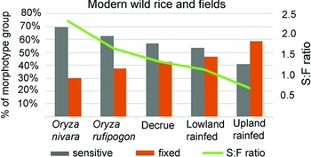
The percentages of fixed morphotypes vs the percentages of sensitive forms demonstrate distinctive patterns in modern analogue rice fields, and the wild rice stands (Figure 5). The wild rice stands are wetter than the cultivated rice fields, and annual wild rice stands are wetter than those growing perennial wild rice (O. rufipogon). At first it might seem counterintuitive that annual wild rice has a wetter signature than perennial rice, as annual wild rice grows in climatically drier conditions. These regions are only seasonally dry however, and during the months when wild O. nivara is growing, it grows under very wet conditions brought on by the rainy season. The rice from the temporarily inundated decrue fields has higher levels of sensitive forms and lower levels of fixed forms than the lowland rain-fed rice, again reflecting the environments in the sampled fields, while in contrast the upland rain-fed rice has higher percentages of fixed and the lowest level of sensitive forms. Overall ratios decrease according to the decrease in water abundance in each arable system and they are wettest in conjunction with wild rice stands.For the three sites in the Lower Yangtze, Tianluoshan, Caoxieshan and Maoshan, there are two questions to address. The first is whether the samples from the fields can be related to specific agricultural systems. The second is whether the remains from the cultural contexts (more typical settlement waste including midden and crop-processing waste) reflect the patterns in the fields.
Percentage of fixed vs sensitive phytolith morphotypes in wild rice stands and modern Indian rice fields; percentages exclude all phytolith types not within the sensitive/fixed classification.

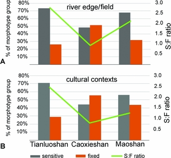
First, we can compare all three sites on the basis of phytoliths from river-edge and paddy field contexts (Figure 6a). The riverside samples from Tianluoshan show high proportions of sensitive morphotypes, consistent with a wetland setting, similar to those settings where wild rice occurs. This is not to say that the rice of the Hemudu period was wild—it was clearly undergoing domestication and in the pre-domestication cultivation stage (Fuller et al. Reference Fuller, Harvey and Qin2007, Reference Fuller and Qin2009)—but that the ecology under which early cultivated rice was managed here is close to the habitat of wild rices. The comparatively high ratio should be expected, as early cultivated rice was managed in habitats akin to those of wild populations, but probably closer to the annual end of that spectrum (Fuller & Qin Reference Fuller and Qin2010; Fuller Reference Fuller2011). In contrast, the phytoliths from small fields at Caoxieshan have many more fixed morphotypes that are consistent with the drier signatures found in cultivated rain-fed or decrue fields among the analogues. This also supports the notion that these fields were kept drier than wild rice stands in order to force the rice to produce seed. Early water control was about drainage rather than irrigation. In the later phase at Maoshan there was a return to domination by sensitive forms but to a slightly lesser extent than in the earlier phase at Tianluoshan. This suggests much wetter conditions, wetter than our Indian-cultivated analogues, which may be expected in highly irrigated paddy systems.
Comparison of the proportion of sensitive vs fixed phytolith morphotypes across three archaeological sites of different phases in the Lower Yangtze: A) comparison of river edge or field palaeosol assemblages; B) comparison of cultural layer/midden context assemblages.

Archaeological samples from typical cultural contexts, associated with occupation debris or middens, show a similar picture in terms of contrasts between sites (Figure 6b). The Tianluoshan samples are dominated by high percentages of sensitive forms. Caoxieshan presents a contrast with more than 50% fixed forms. Maoshan shows a return to higher levels of sensitive morphotypes but not as high as the samples from the drained fields, which have a much lower sensitive-to-fixed ratio than the paddy field samples. This may be because a greater proportion of the grass leaves from Maoshan are not from crop processing like those at the other sites, and harvesting methods may have targeted a higher portion of plants (mainly panicles). This could be linked to the widespread occurrence of hand-harvest knives (sickles) in the Liangzhu period. It is also possible that other non-crop weed grasses entered assemblages regularly, such as those grasses used in roofing or matting. Nevertheless, the contrasts with earlier Caoxieshan samples indicate wetter conditions, suggesting that a signal from the arable rice environment is present. Thus, phytolith assemblages from both kinds of contexts appear to reflect the same underlying patterns of phytolith input from rice habitats.
The general trend is the same from both field and cultural deposit samples, and these agree on the chronological changes, but there are still some contrasts between sample types from Maoshan. At Maoshan the field samples have higher percentages of sensitive forms and the sensitive-to-fixed ratio is lower in the assemblages from the cultural contexts. This indicates that some wet indicators or plant parts from these well-watered grasses remained in the field rather than being harvested. This is expected as these morphotypes occur in grass leaves, only a fraction of which enter the harvest. When both sets of results are shown together (Figure 6), it is clear that the wet field samples from Maoshan and the pre-domestication cultivation samples from Tianluoshan have high sensitive-to-fixed ratios like our modern wild rice stands (Figure 5).
Conclusions
The phytolith samples from the cultural contexts at these three sites show similar patterns to those from the archaeological field systems, although the contrasts are not as marked. We suggest that this relates to harvesting practices whereby the harvested material included a smaller proportion of the grass leaves overall (from the crop or weeds) that were present in the field. At Tianluoshan the percentage of sensitive to fixed is almost the same in samples from cultural contexts as it is in those from the fields, suggesting the grass leaves from the site are predominantly crop-processing waste. At Caoxieshan, as at Tianluoshan, there were more fixed forms in the cultural contexts than in the samples from the fields but the difference is slight. The phytolith assemblage from the Maoshan site has a lower sensitive-to-fixed ratio than the paddy field samples. This may be because a greater proportion of the grass leaves from Maoshan came from sources other than crop processing. Non-crop weed grasses may have been used in roofing, matting or basketry and so on. Despite differences between field and domestic context samples within each site, the time series between sites, either in field samples or in domestic refuse samples, reflects the same chronological patterns of change to arable ecology over time between wetter and drier conditions. This means that this method is applicable to archaeological samples from cultural contexts as well as those from ancient field systems.
The results of applying this model to the phytoliths from Tianluoshan, Caoxieshan and Maoshan demonstrate that it is a good method for differentiating between arable field systems. It is possible to envisage early rice cultivation along the river at Tianluoshan. A comparable phytolith signature was provided by the stands of wild rice growing in India, making it easy to picture the development of rice husbandry at Tianluoshan by the seeding and management of a wetland margin. At Caoxieshan the fields were drier, and it seems likely that the small fields at Caoxieshan were rain-fed, and that water control efforts were directed at drying out the fields strategically. The development of large paddy fields at Maoshan can be traced in the increase in sensitive forms in the phytolith assemblage. This method has hence proved to be a useful tool for exploring and understanding developments in early rice farming.
Acknowledgements
Excavations were supported by the Suzhou Museum at Caoxieshan and Zhejiang Province Institute of Archaeology and Cultural Relics at Tianluoshan and Maoshan. The fieldwork and initial analyses were carried out with a grant from the UK Natural Environment Research Council (NERC) entitled ‘The identification of arable rice systems in prehistory’ (NE/G005540/1). Our continuing analyses, reported here, are supported by a NERC grant on ‘The impact of evolving rice systems from China to Southeast Asia’ (NE/K003402/1).
Supplementary material
To view supplementary material for this article, please visit http://dx.doi.org/10.15184/aqy.2015.94