Introduction
Antarctica has long been a prime location for scientific research. Increasing scientific interest in Antarctica has amplified the demand for new research stations. Due to the climatic extremes and geographical isolation of Antarctica, research stations using modern technology are essential to protect personnel from the environment and to provide an adequate level of comfort that enables researchers to live and work safely. To guarantee the quality of station construction and the range of scientific activities intended to be based there, the accurate identification and characterization of site suitability are crucial. Furthermore, accurate identification of site suitability narrows the investigative scope and reduces expense.
The nature of the Antarctic environment requires consideration of multiple evaluation criteria to determine suitable locations for research stations. In previous studies, a variety of influential factors were utilized in the selection process by different countries. These studies are documented in various formats: comprehensive environmental evaluation (CEE) reports, papers, unpublished reports, websites, etc. The majority of the factors can be found in the CEE reports published for the Norwegian summer station Troll (NPI 2004), the German Neumayer III Station (AWI 2005), the Belgian research station (Belspo 2007), the British Halley VI Station (BAS 2007), the Indian research station (NCAOR 2010) and the Korean Jang Bogo Station (KOPRI 2012). However, none of these studies have published a comprehensive criteria system which would have made it possible for such a system to be analysed quantitatively. In this study, we propose to conceptualize a criteria system based on field experience and literature.
Using traditional methods the site selection process is a time-consuming, qualitative analytical procedure, which involves qualitative considerations and subjective judgements. For example, site candidates are initially allocated by experts, then field investigations are carried out to examine the potential sites (KOPRI 2012). Only a small number of decision-makers are involved in the site selection process, and the uncertainty in their knowledge and bias in their judgements have seldom been reported or analysed in a quantitative way. Additionally, the allocation model results can be influenced by the uncertainty inherent in describing and ranking available criteria and spatial variables (Vahidnia et al. Reference Vahidnia, Alesheikh and Alimohammadi2009). Therefore, our primary goal was to determine a robust allocation method, one that combines both qualitative and quantitative analyses. To minimize the adverse impact of uncertainties, we chose the fuzzy analytical hierarchy process (FAHP) to organize multiple criteria and to address the uncertainty inherent in prescribing weight to each criterion.
This study proposes to use geographical information systems (GIS) based on the FAHP to select the optimum sites for Antarctic research stations. This selection process combines quantitative analysis with traditional qualitative considerations, enabling site selection to be more scientific and systematic. The sub-criteria were analysed according to their relative importance and suitability scores using GIS in a hierarchical manner, based on the FAHP, to produce an overall suitability map. Subsequently, we used the proposed new Chinese Antarctic research station as an example to illustrate how to take advantage of the model results to determine the most suitable sites for a new station and to reduce the extent of field investigations.
Study area
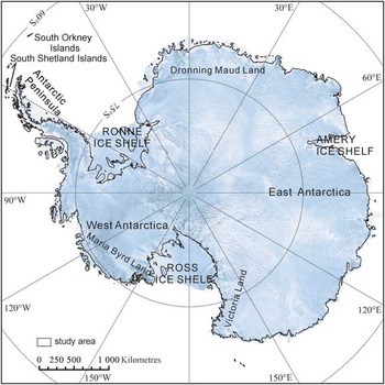
The study area covers a major portion of Antarctica (Fig. 1), occupying approximately 12 086 200 km2.
The extent of the study area.

Due to the movement of ice shelves and the significant snow accumulation in these areas, most stations built on the ice shelves have been abandoned, including Halley I to IV stations (BAS 2007). Modern building technology may have eliminated the adverse effects of snow accumulation. However, considerable time and expense are required to design and test the construction of stations on an ice shelf. Therefore, ice shelves, covering approximately 10% of Antarctica, were excluded from this study. Additionally, the South Orkney Islands were not included both on scientific grounds and because of the distance between the islands and the Antarctic continent.
The inland regions of Antarctica are much drier and colder than the coastal regions, and are generally situated at a higher elevation. The total annual precipitation in Antarctica, averaged over the entire continent, is approximately 151 mm, with approximately 200 mm of precipitation along the coast and far less inland (Cullather et al. Reference Cullather, Bromwich and van Woert1998). The lowest recorded Antarctic temperature, -93.2°C (-135.8°F), was measured on the highest section of the East Antarctic ice divide in August 2010 (Campbell et al. unpublished). Therefore, the construction of inland research stations requires a higher level of technical support and more detailed investigation.
To develop Antarctic scientific research in a sustainable way, the protection and management of Antarctic biota must be taken into consideration when choosing research sites.
Methodology
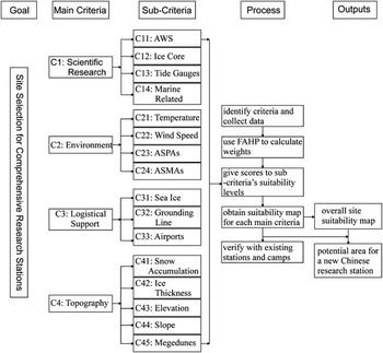
The FAHP and GIS were used to build a hierarchical criteria structure and to integrate all of the spatial data, thereby generating a suitability map. Five main steps were included in this process: i) build the criteria system (identify the main criteria and the related sub-criteria, and collect corresponding or alternative data showing the spatial distribution of criteria), ii) use the FAHP to calculate the suitability index (the weight of each of the main criteria and sub-criteria), iii) give suitability scores to each sub-criterion on the map, iv) employ GIS to aggregate the weights and scores into different levels and to obtain an overall suitability map, and v) verify the accuracy of the model result with existing stations and camps using GIS capability. To select a site for a new Chinese Antarctic research station, we analysed the current network of Chinese research stations to identify problem areas, and further reduced the candidate sites based on the locations of all existing stations and scientific interests of Chinese researchers. This process is illustrated in Fig. 2.
Schematic diagram of the modelling procedure for site selection for a major Antarctic research station.

Criteria system identification and data collection
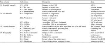
This site selection process is designed for major research stations. The system for selecting the optimum sites for station building in Antarctica is developed under a hierarchical structure, which breaks down all criteria into small groups in different levels. Criteria, identified as influential factors (Hossain et al. Reference Hossain, Chowdhury, Das, Sharifuzzaman and Sultana2009), are grouped according to the similarity of the elements with respect to the function they perform or properties that they share (Saaty Reference Saaty1980). The chosen identification criteria are based on an extensive literature review. This criteria system is derived from the CEEs for the German Neumayer III Station (AWI 2005), the Norwegian summer station Troll (NPI 2004), the Belgian research station (Belspo 2007), the British Halley VI Station (BAS 2007), the Indian research station (NCAOR 2010) and the Korean Jang Bogo Station (KOPRI 2012). To maintain a comprehensive, operational, non-redundant and minimal criteria system, four main criteria were chosen: scientific research, environment, logistical support and topography. Fifteen sub-criteria were organized under these main criteria providing more detailed information. Brief descriptions of the main criteria and related sub-criteria are listed in Table I.
Main criteria, sub-criteria and related data.

ASMA = Antarctic Specially Managed Area, ASPA = Antarctic Specially Protected Area, AWS = automatic weather station, DEM = digital elevation model.
The primary purpose of the proposed station is scientific research. The scientific research criteria identify locations where crucial surveys have been carried out. The majority of Antarctic studies are conducted near the ocean. Therefore, we use marine-related criteria to cover the scope of these studies. Furthermore, as global climate change receives worldwide attention, a major research station should be able to provide a significant contribution to international efforts to investigate global environmental change. Data from automatic weather stations (AWSs), tide gauges and ice cores all provide data on climate change. Scientific equipment requires regular maintenance; therefore, the stations that house this equipment need to be accessible.
The impact of the construction and operational activities of research stations on the Antarctic terrestrial ecosystem needs to be minimized. Therefore, the sub-criteria focussing on the environment include physical (temperature and wind speed) and ecosystem factors. It should be noted that prevailing wind is stressed in almost all of the CEEs. Prevailing winds, specifically katabatic winds, could result in significant snow accumulation that could disrupt construction. Antarctic Specially Protected Areas (ASPAs) and Antarctic Specially Managed Areas (ASMAs) are listed as alternatives to ecological criteria because they are designated to preserve unique natural ecological systems, such as bird or seal colonies, or biologically-rich terrestrial communities and to protect them from human disturbances (Annex V: Protected Area System, Protocol on Environmental Protection to the Antarctic Treaty 1991; SCAR 1993).
To maintain an operational station, logistics cannot be ignored. Logistical support for Antarctic expeditions is dependent upon marine and air travel. The candidate site must be accessible by ship for as long as possible in the summer, and therefore must be a relatively short distance from the ice edge (anchorage ground). The station should be reachable by ship not only for economic reasons but also for safety reasons. As ice shelves were excluded from the study area, the grounding line, i.e. the boundary between the floating ice shelf and the grounded (resting on bedrock) ice, is also taken into account. Furthermore, air transportation networks, such as Dronning Maud Land Air Network Project (DROMLAN), are available to facilitate travel to/from and within Antarctica for members of the Council of Managers of National Antarctic Programmes (COMNAP) and the Scientific Committee for Antarctic Research (SCAR) for science-related activities. Fixed-wing aircraft fly from the two main airfields, located at the Troll Station and the Novolazarevskaya Station, to other Antarctic destinations. Therefore, an airport sub-criterion is included in the logistical support criteria.
Topographical conditions are fundamental to the construction of a station. According to the CEE of the Belgian research station (Belspo 2007), high snow accumulation rates and strong winds are the principal causes of the abandonment of Antarctic research stations. Therefore, the snow accumulation rate should be considered as one sub-criterion under this group. To extend the service life of stations for sustainable development, the ice thickness sub-criterion should limit selection to areas with exposed bedrock in summer, which allows for stability in construction. In addition, the open ground surrounding the station should be flat enough to allow for the preparation and maintenance of an airstrip in summer, and for easy access to the hinterland by vehicles. Antarctic megadunes are long, undulating waves on the surface of the ice sheet. Megadunes are not a safe location for station construction and are inconvenient for Antarctic field investigations. Similar limitations concerning safety and convenience apply to locations at high elevations.
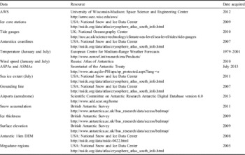
To facilitate the site selection process, GIS is used as a tool for the management, manipulation, representation and analysis of spatial data. Spatial data were collected from various resources (Table II). The resolution was integrated at the lowest value of 1000 m, using a digital elevation model (DEM), to make comparisons. All maps and thematic data were transformed into Stereographic South Pole projections. Spatial data were prepared and implemented in the GIS software ArcGIS as separate spatial layers during the entire modelling process. Some topographical data, such as elevation, slope and grounding lines, were acquired several years ago, but we have assumed that little change has occurred since these measurements were taken. Furthermore, between 1957 and 2006, the continent-wide warming trend was approximately 0.12 ± 0.07°C per decade (Steig et al. Reference Steig, Schneider, Rutherford, Mann, Comiso and Shindell2009). Compared with the isotherms (in degrees), the error in this temperature trend is negligible.
Resources for spatial data and date acquired.

ASMA = Antarctic Specially Managed Area, ASPA = Antarctic Specially Protected Area, AWS = automatic weather station, DEM = digital elevation model.
Fuzzy analytical hierarchy process
The analytical hierarchy process (AHP), initiated by Saaty (Reference Saaty1980), is a flexible, multi-criteria, decision-making methodology that transforms a complex problem into a hierarchy with respect to one or more criteria (Mohajeri & Amin Reference Mohajeri and Amin2010), each of which can be analysed independently. In this study, the hierarchy was constructed to involve the four main criteria and their sub-criteria (Fig. 2 & Table I). The FAHP is an extension of the AHP that takes into account the inherent uncertainty and imprecision of human thinking in the decision-making process. The use of the FAHP allows decision-makers to express approximate preferences using fuzzy memberships to add fuzziness into their judgement (Mikhailov & Tsvetinov Reference Mikhailov and Tsvetinov2004, Erensal et al. Reference Erensal, Öncan and Demircan2006, Lee et al. Reference Lee, Chen and Chang2008, Wang et al. Reference Wang, Luo and Hua2008). Specifically, the single-valued element in the AHP is replaced by a triangular fuzzy number ãij, denoted as ãij = (lij , mij , uij ). After determining the hierarchy, a pairwise comparison matrix à is set up to estimate the weight of each criterion according to Equation 1.
 $$\mathop{A}\limits^{\sim } \, = \,\left[ {\matrix{ {\mathop{{a11}}\limits^{\sim } } & {\mathop{{a12}}\limits^{\sim } } & \cdots & {\mathop{{a1n}}\limits^{\sim } } \cr {\mathop{{a21}}\limits^{\sim } } & {\mathop{{a22}}\limits^{\sim } } & \cdots & {\mathop{{a2n}}\limits^{\sim } } \cr \vdots & \vdots & \vdots & \vdots \cr {\mathop{{an1}}\limits^{\sim } } & {\mathop{{an2}}\limits^{\sim } } & \cdots & {\mathop{{ann}}\limits^{\sim } } \cr } } \right],\eqno\rm$$
where lij , mij , and uij are the x-coordinates of the three endpoints of the triangular number. The triangular number ãij (1 ≤i, j ≤n) is the relative importance value of criterion Ci to criterion Cj , and all of the elements in the comparison matrix are positive, ãij = (1/uij , 1/mij , 1/lij ).
The consistency ratio (CR) of à should be examined. If à is a completely consistent pairwise comparison matrix, numerous constraints should be satisfied in the construction of Ã. Instead, we allow à to have some degree of inconsistency and adopt a consistency index (CI), to measure consistency as follows:
 $$CI\, = \,{{\lambda _{{\max }} \,{\rm - }\,n} \over {n\,{\rm - }\,1}},\eqno\rm$$
where λmax is the maximum eigenvalue of Ã. Usually, a CI is used along with a random consistency index (RI) to derive the CR (Saaty Reference Saaty1980). RI is a randomly generated reciprocal matrix. We adopted the values of RI from a previous study by Brent et al. (Reference Brent, Rogers, Ramabitsa-Siimane and Rohwer2007), in which average values for matrices of orders 1–15 have been generated from a sample size of 100:
 $$CR\, = \,{{CI} \over {RI}}.\eqno\rm$$
If the value of CR is no greater than 10%, the inconsistency of à is considered acceptable. Otherwise, ãij should be reconsidered and modified.
There are various FAHP methods in the literature (such as Van Laarhoven & Pedrycz Reference van Laarhoven and Pedrycz1983, Buckley Reference Buckley1985, Chang Reference Chang1996, Leung & Cao Reference Leung and Cao2000). In this study, we adopted the extent analysis method by Chang (Reference Chang1996) to calculate the suitability index because this approach is more easily achieved relative to other FAHP approaches. Following the selection of criteria, linguistic scales representing relative importance were defined for levels of preference according to Kahraman et al. (Reference Kahraman, Ertay and Büyüközkan2006), shown in Table III.
Triangular fuzzy numbers corresponding to linguistic scales that represent levels of preference.


Weight of criteria and sub-criteria
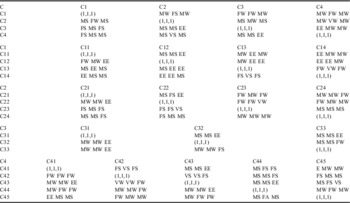
After determining the criteria system and the triangular fuzzy numbers for the weights, the fuzzy extent analysis algorithm of the FAHP was executed. The weights were determined by expert surveys. Due to limitations on time and resources, three experts in geodetic surveys, remote sensing and ecosystems were invited to assign the weights. Table IV gives the pairwise comparison matrixes of the main criteria and sub-criteria that were scored. To obtain a matrix such as Ã, Equations 2 & 3 are used to calculate the arithmetic means of the fuzzy scores in Table IV to obtain the CRs.
Pairwise comparisons of the main criteria and sub-criteria.

EE = equal, ES = extremely strong importance, EW = extremely weak importance, FS = fairly strong importance, FW = fairly weak importance, MS = moderately strong importance, MW = moderately weak importance, VS = very strong importance, VW = very weak importance.
To verify the CR of the evaluation matrixes, the graded mean integration approach is then utilized to transform the fuzzy number ã = (l, m, u) into a crisp number by employing the equation below (Yong, Reference Yong2006):
 $$$P(\mathop{a}\limits^{\sim } )\, = \,a\, = \,\displaystyle{{{l\, + \,4m\, + \,u} \over 6}.$\eqno\rm$$
Finally, normalized weight vectors of the main criteria and sub-criteria are obtained.
Suitability scores
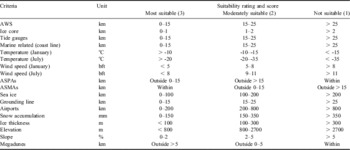
Each sub-criterion was given scores at different locations on the map based on levels of suitability, i.e. the most suitable was scored at 3, moderately suitable scored 2 and not suitable scored 1. For each map of a sub-criterion, the suitability ratings and the ranges of buffers for the three classes of suitability scores are defined according to survey results, the professional judgement of Chinese experts and the published CEEs (Table V).
Suitability scores of sub-criteria for station building in Antarctica.

ASMA = Antarctic Specially Managed Area, ASPA = Antarctic Specially Protected Area, AWS = automatic weather station.
According to the feedback of a Chinese Antarctic expedition team, helicopters are the most commonly used aircraft in Antarctica and can provide aviation support within 200 km of an airfield, whereas fixed-wing aircrafts can expand the extent of aviation support to within 800 km of an airfield. Therefore, the most suitable area for logistic support is within 200 km of an airport and moderately suitable areas are within 200–800 km of an airport.
Location within 15 km of observation stations (e.g. AWSs, tide gauges and ice cores) is considered to be most suitable to facilitate efficient servicing and research. Furthermore, the sites for observation stations are considered carefully prior to construction to ensure collection of data relevant to the scientific interests, such as global climate change, thus the position may indicate a good research environment. Although many AWSs can be operated remotely from research stations, location within 15 km of observation stations is preferable.
Wind speeds over 8 on the Beaufort scale (bft) during summer indicate that a location may not suitable for long-term field operations due to the risks to personnel and buildings. It should be noted that as there are few buildings in Antarctica the destructive power of wind on buildings is reduced. Moreover, wind power can serve as an energy supply.
Areas within ASPAs are not available for station construction while those within ASMAs are suitable in some cases. Antarctic terrestrial ecosystems are widely acknowledged as being vulnerable to human disturbance, and this fragility has been recognized within the Antarctic Treaty by the designation of protected areas (Tejedo et al. Reference Tejedo, Justel, Benayas, Rico, Convey and Quesada2009). Activities in ASPAs and ASMAs are prohibited, restricted or managed in accordance with management plans. ASPAs are designated to protect environmental, scientific or wilderness value associated with ongoing or planned scientific research. Without a permit, entry into an ASPA is prohibited. ASMAs, in contrast, are areas where activities are being conducted or may in the future be conducted. They are designated to ‘assist in the planning and coordination of activities, avoid possible conflicts, improve co-operation between parties or minimize environmental impacts’ (SCAR 1993). A permit is not needed to enter into an ASMA. Therefore, ASMAs are suitable for station construction and may have positive benefits for the environment by building stations in facility zones, where stations already exist, and sharing infrastructure which may reduce the area of mutual interference.
Suitability maps and model verification
Once the suitability scores had been determined, the corresponding data were buffered to produce suitable zones (Table V). Considering the variety of data types, resolutions of different layers were transformed into comparable size. Thus, the analysed data were converted into a grid with a 1000 × 1000 m cell size, which was the lowest resolution from the DEM data to be identified within the study area. According to their suitability scores, the buffered zones with different ranges were assigned with ‘3’ for most suitable, ‘2’ for moderately suitable and ‘1’ for not suitable. Scores on reclassified buffer maps of each sub-criterion (e.g. GridAWS) were multiplied by their respective weights (e.g. WC11) and summed in GIS software to produce a suitability map for each main criterion.
 $${ {\rm Grid}_{{{\rm scientific}\;{\rm research}}} \,{\rm = }\,&{\rm Grid}_{{{\rm AWS}}} \,{\rm \times }\,{\rm W}_{{{\rm C11}}} \,{\rm + }\,{\rm Grid}_{{{\rm ice}\;{\rm core}}} \,{\rm \times }\,{\rm W}_{{{\rm C12}}} \cr &\,{\rm + }\,{\rm Grid}_{{{\rm tide}}} \,{\rm \times }\,{\rm W}_{{{\rm C13}}} \,{\rm + }\,{\rm Grid}_{{{\rm marine}}} \,{\rm \times }\,{\rm W}_{{{\rm C14}}} \cr} \eqno\rm$$
 $$ { {\rm Grid}_{{{\rm environment}}} \,{\rm = }\,&{\rm [(Grid}_{{{\rm temp1}}} \,{\rm + }\,{\rm Grid}_{{{\rm temp7}}} {\rm )}\,{\rm \times }\,{\rm W}_{{{\rm C21}}} {\rm ]/2}\,\cr &{\rm + }\,{\rm [(Grid}_{{{\rm wind1}}} \,{\rm + }\,{\rm Grid}_{{{\rm wind7}}} {\rm )} \,{\rm \times }\,{\rm W}_{{{\rm C22}}} {\rm ]/2}\,\cr &{\rm + }\,{\rm Grid}_{{{\rm ASPAs}}} \,{\rm \times }\,{\rm W}_{{{\rm C23}}} \,{\rm + }\,{\rm Grid}_{{{\rm ASMAs}}} \,{\rm \times }\,{\rm W}_{{{\rm C24}}} \cr} \eqno\rm$$
 $${{\rm Grid}_{{{\rm logistical}\;{\rm support}}} \,{\rm = }\,&{\rm Grid}_{{{\rm sea}\,{\rm ice}}} \,{\rm \times }\,{\rm W}_{{{\rm C31}}} \,{\rm + }\,{\rm Grid}_{{{\rm grounding}}} \,\cr &{\rm \times }\,{\rm W}_{{{\rm C32}}} \,{\rm + }\,{\rm Grid}_{{{\rm airports}}} \,{\rm \times }\,{\rm W}_{{{\rm C33}}} \eqno\rm$$
 $${ {\rm Grid}_{{{\rm topography}}} \,{\rm = }\,&{\rm Grid}_{{{\rm snow}}} \,{\rm \times }\,{\rm W}_{{{\rm C41}}} \,{\rm + }\,{\rm Grid}_{{{\rm ice}}} \,{\rm \times }\,{\rm W}_{{{\rm C42}}} \,\cr &{\rm + }\,{\rm Grid}_{{{\rm elevation}}} \,{\rm \times }\,{\rm W}_{{{\rm C43}}} \,{\rm + }\,{\rm Grid}_{{{\rm slope}}} \,{\rm \times }\,{\rm W}_{{{\rm C44}}} \,\cr &{\rm + }\,{\rm Grid}_{{{\rm megadunes}}} \,{\rm \times }\,{\rm W}_{{{\rm C45}}} \cr} \eqno\rm$$
Finally, the suitability maps of the main criteria were aggregated to produce the overall suitability model:
 $$ { {\rm Overall}\,\,{\rm suitability}\,\,{\rm map}\,{\rm = }\,&{\rm Grid}_{{{\rm scientific}\,\,{\rm research}}} \,{\rm \times }\,{\rm W}_{{{\rm C1}}} \,\cr & {\rm + }\,{\rm Grid}_{{{\rm environment}}} \,{\rm \times }\,{\rm W}_{{{\rm C2}}} \,\cr & {\rm + }\,{\rm Grid}_{{{\rm logistical}\,\,{\rm support}}} \,{\rm \times }\,{\rm W}_{{{\rm C3}}} \,\cr & {\rm + }\,{\rm Grid}_{{{\rm topography}}} \,{\rm \times }\,{\rm W}_{{{\rm C4}}} \cr} \eqno\rm$$
Model verification was carried out, using GIS capabilities, by comparing the locations of existing stations and camps with the suitability zones on the overall suitability map. Since this model was designed for allocating a site for a new research station, all of the existing stations and camps in Antarctica were included in the verification assessment.
Results
Weights of main criteria and sub-criteria
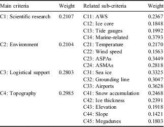
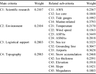
The weights of the main criteria and sub-criteria were derived (Table VI), and all of the CRs were found to be in a satisfactory range (0.0357–0.0837). Topography (WC4 = 0.2985) was the most important parameter for site selection, followed by logistical support (WC3 = 0.2803), scientific research (WC1 = 0.2107) and environment (WC2 = 0.2104).
Normalized weight vectors of main criteria and related sub-criteria.
ASMA = Antarctic Specially Managed Area, ASPA = Antarctic Specially Protected Area, AWS = automatic weather station.
Among sub-criteria under scientific research, marine-related research (WC14 = 0.3793) proved to be the most important because much scientific research in Antarctica is related to the ocean, and the location of bird colonies, many AWSs, tide gauges, GPS observation stations and permanent geomagnetic observatory sites are also located near the coast. The second highest weight among the scientific research sub-criteria was that of AWSs (WC11 = 0.2367) ensuring that the locations of AWSs had a significant impact on site selection.
ASPAs account for the most important element of the environment criteria (WC23 = 0.3449). The weight of this sub-criterion indicates its importance as designated both by experts and by our decision model. ASMAs (WC24 = 0.2818) taking the second place in the environment group. Since stations may already exist in the ASMAs, localizing human activities and sharing infrastructure in facility zones may help to protect the local ecosystem. Temperature and wind speed are also significant environmental sub-criteria (WC21 = 0.2170 and WC22 = 0.1563, respectively). They affect the cost of a station's construction and the capacity of a site to support scientific study.
The three sub-criteria in the logistical support group are of relatively the same importance, and all of the weights of these sub-criteria are above 0.3. Sea ice and grounding line sub-criteria are closely related to marine traffic, therefore, sea transportation receives more weight (WC31 + WC32 = 0.6372) than air transportation (WC33 = 0.3628), which is in accordance with the reality that travel to and within Antarctica has traditionally been by sea.
To extend the service life of a station, areas with high snow accumulation rates should be avoided. Furthermore, construction on bedrock rather than a snow surface increases a station's lifespan. Consequently, among the topographic conditions, snow accumulation and ice thickness have obvious impacts on a research station's construction and thus obtained high weights of approximately 0.24. However, the other three sub-criteria (elevation, slope and megadunes) are less important and were weighted between 0.1412 and 0.1918.
Suitability maps
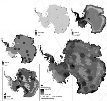
The suitability map for scientific research is shown in Fig. 3a. The suitable area can be divided into two parts, points in inland Antarctica and the area near the grounding line. The points inland are all close to routine observation stations, such as AWSs, tide gauges and ice cores. The areas near the grounding line are suitable for marine-related studies. This map illustrates appropriate working environments for topical research interests. However, the specific research programmes initiated in future stations will be determined by prospective scientific interests and research plans.
Suitability maps. a. Scientific research. b. Environment. c. Logistical support. d. Topography. e. Overall suitability map.

The suitability map for environment is shown in Fig. 3b. Whilst technology is used to overcome the extreme weather of Antarctica, areas affected by strong prevailing winds should be avoided to ease station maintenance.
The suitability map for logistical support is shown in Fig. 3c. This map is similar to Fig. 3a in that it focusses on the edge of the study area and on specific points inland. However, the buffer zones around points in Fig. 3c are greater than those in Fig. 3a because the coverage of air transport is wider than the scope of field investigations.
The topographical map (Fig. 3d) is different from the other three maps because inland Antarctica, with the exception of the megadune regions, is flat with low levels of snow accumulation, thus satisfying construction conditions, whereas the area near the coast has exposed bedrock with undulating terrain and high snow accumulation rates.
The most suitable sites for Antarctic research stations (Fig. 3e) are identified as those having acceptable topographical conditions with good logistical support, favourable temperatures and wind speeds, and those that are an acceptable base for scientific research. The most suitable sites are centred on the South Shetland Islands, the Antarctic Peninsula and areas around the grounding line. Constrained by environmental and topographical conditions, the majority of the Antarctic hinterland is less suitable for station building.
Verification of the suitability model
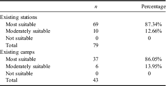
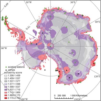
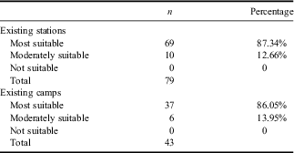
The locations of 79 existing stations and 43 camps (Antarctic Digital Database 6.0) were compared with suitability zones on the overall suitability map. Geometric interval classification was applied to separate the continuous suitability scores on the overall suitability map into nine clusters by minimizing the square sum within the clusters and maximizing the difference between clusters. The nine clusters were then grouped into three general categories: the top three clusters with higher suitability values were designated as ‘most suitable’, the middle three as ‘moderately suitable’ and the remaining three clusters as ‘not suitable’. The results are shown in Table VII and Fig. 4. All existing stations and camps are in the most suitable and moderately suitable zones. The most suitable zone on the overall suitability map includes 87.34% of the existing stations and 86.05% of the camps. The modelled output, therefore, agrees with site selection performed thus far.
Comparison of the locations of existing stations and camps with the overall suitability map.
Location of the existing stations and camps on the overall suitability map.

Optimal site for the new Chinese Antarctic research station
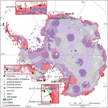
We used this model to select a site for a new Chinese research station. China already has three Antarctic research stations: Changcheng Station on the South Shetland Islands, Zhongshan Station in East Antarctica near the Amery Ice Shelf and Kunlun Station in inland Antarctica next to Dome A (Fig. 5). Changcheng and Zhongshan are year-round stations, and Kunlun Station is a seasonal station focussed on the study of the inland topography and ice cores. To form a research network and strengthen the scientific research platform, we gave priority to the areas in Dronning Maud Land (Area D), Victoria Land (Area V) or Marie Byrd Land (Area M), shown in Fig. 5. Any of these areas, if chosen, would greatly enhance the coverage of the Chinese research network.
Potential areas and optimal sites for a new Chinese Antarctic research station.

Taking the most suitable areas and locations of other countries’ existing stations into consideration, the suggested final sites are shown in Fig. 5. Suitable environmental conditions are conducive to field research, and the adjacency to the coast facilitates water supply and logistical support. In Area D, the optimal site could be at approximately 0.4°E/71.4°S, 5.9°W/71.4°S or 6.4°E/70.4°S. Air transportation makes this area easy to access. In Area V, 166.7°E/77.3°S, 162.5°E/76.4°S and 163.9°E/74.9°S appeared to be the best site locations based on field investigations. There are numerous AWSs and tide gauges already established on the ice shelf, providing a good foundation for scientific study. In Area M, 136.7°W/74.8°S (near the Russkaya Station) and 157.8°W/77.2°S could be appropriate locations. There are no stations at these locations yet, and placing a new station in a new area would encourage scientists to explore a new part of the continent and may yield greater scientific insights. Further fieldwork is necessary to gather detailed information for the ideal station location. The areas chosen to conduct further fieldwork will depend on the scientific interests of the Chinese Antarctic expedition.
Discussion
The results of this study indicate that GIS, combined with the FAHP, can be a valuable tool to identify and verify potential sites for Antarctic research stations. The application of GIS as an analytical tool allowed for the quantitative study of correlations between thematic data, and a FAHP procedure was applied to overcome the uncertainty inherent in decision-making processes. These applications made the site selection process efficient and effective. This model took scientific research, environmental, logistical and topographical criteria into account, based on the sustainable development of Antarctic academic research. The selection of sub-criteria and the identification of the relative importance of these sub-criteria are flexible and can be adjusted to offer solutions for other stations aimed at a specific expedition or emphasizing specific strategic significance. We consider that this process of analysis is suitable not only for China but for other countries with similar requirements.
We proposed a fuzzy hierarchy model to incorporate information from various resources. The expert system has been used previously to determine pairwise comparisons but this is usually biased and subjective. In this study, which was limited by time and other factors, we invited only three experts to give evaluations. However, the model has enough flexibility to allow the involvement of as many scientists from different research fields in the evaluation as necessary, potentially minimizing any one subjective influence on decisions. When compared with the AHP, the FAHP is superior because the fuzzy method incorporates uncertainty into comprehensive information and linguistic variables. Therefore, the results are more reasonable and reliable.
It is essential to consider weaknesses of the fuzzy extent analysis. According to Wang et al. (Reference Wang, Luo and Hua2008), this method has two main problems: i) zero weight may be assigned to a decision criterion, leading to it not being considered in the analysis and ii) the weights determined may not represent, or may mislead, the relative importance of decision criteria; thus weights cannot be used as priorities. However, in the site selection process, these two potential drawbacks are actually important features. During site selection, the areas deemed not suitable should be excluded from the study (Vahidnia et al. Reference Vahidnia, Alesheikh and Alimohammadi2009). Furthermore, there is no need to judge the priorities because the goal is to detect the site of prime importance to the decision-maker, and the relative importance of various criteria is provided by the decision-makers, and differences are evaluated by the CRs.
Applying fuzziness to judgement cannot compensate for a lack of relevant data. Due to the paucity of fine-scale quantitative data, the resolution was integrated at the lowest value of 1000 m, which is the value used for the DEM. The low resolution resulted in the loss of a considerable amount of information in the integration process. Therefore, a straightforward improvement of the current work would be to improve the resolution of the data to give detailed geo-references for engineering and construction.
To minimize the disturbance of the Antarctic environment by human activities, particularly during construction and transport related to a research station, fieldwork is essential to supplement the site selection decision. There is considerable spatial overlap between humans and wildlife in terrestrial Antarctica, particularly on the small areas of ice-free ground in coastal regions where marine mammals and seabirds come to breed and where terrestrial vegetation is found (Convey et al. Reference Convey, Hughes and Tin2012). The adverse impacts of human activities, such as chemical and sewage contamination, and the disturbance of flora and fauna at many different levels of biological organization, are considered in this study, which potentially leads to much higher cumulative impacts on the environment and intensifies the pressure on individual sites at a local scale (Tin et al. Reference Tin, Fleming, Hughes, Ainley, Convey, Moreno, Pfeiffer, Scott and Snape2009). ASPAs and ASMAs were developed to minimize the environmental disturbance in specific areas. However, detailed data concerning areas that need to be protected are insufficient because of imperfect knowledge and a lack of appropriate surveys (Chown et al. Reference Chown, Lee and Hughes2012, Convey et al. Reference Convey, Hughes and Tin2012). Thus, even though the GIS model performs a quantitative analysis for decision-making and produces suggestions for optimal research station sites, fieldwork is still indispensable to ensure that the locations for potential stations do not conflict with wildlife.
Conclusions
With increasing demand for Antarctic scientific research, the site selection process for Antarctic research stations is one of great importance. In this study, we systematically constructed a criteria system for site selection for a major Antarctic research station. A GIS model integrated with a multi-criteria evaluation technique, the FAHP, was developed for optimal site selection. From the perspective of facilitating scientific investigation and improving station maintenance, an overall suitability map was determined based on four main criteria (scientific research, environment, logistical support and topography) and fifteen sub-criteria. This suitability map is consistent with the locations of current research stations. Based on the resulting model output, the most suitable sites for a new Chinese Antarctic research station, and potential alternatives, are in Dronning Maud Land (0.4°E/71.4°S, 5.9°W/71.4°S or 6.4°E/70.4°S), Victoria Land (166.7°E/77.3°S, 162.5°E/76.4°S or 163.9°E/74.9°S) and Marie Byrd Land (136.7°W/74.8°S or 157.8°W/77.2°S).
We conclude that the proposed criteria, organized as a hierarchical multi-criteria system based on the FAHP as a robust allocation method and on GIS as an efficient spatial data management tool, form a good combination for a complex, objective and scientific method to select a site for a research station in Antarctica. This process of analysis is suitable not only for China but for other countries with similar requirements.
Acknowledgements
This research was funded by the Project of Chinese National Bureau of Oceanography (grant no. 20120202) and the National Natural Science Foundation of China (grant no. 41301463). The authors would like to express their many thanks to the scientists and experts from the Chinese Antarctic Center of Surveying and Mapping, Wuhan University, for providing the expert-defined scores of the FAHP, and to two anonymous reviewers for their valuable and constructive comments.