
The Mesopotamian historian's myopia is, of course, matched by the prehistorian's tendency to fold his or her tent and steal away at the dawn of history.
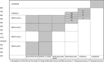
Norman YoffeeFootnote 1This article seeks to identify and understand the structural changes in late prehistoric societies that generated rapid state formation. It is geographically restricted to the Mun Valley of northeastern Thailand and the adjacent lowlands of northern Cambodia. This entails dovetailing two sources of information. There is a growing corpus of archaeological data with which to review the prehistoric Iron Age. However, with the early historic period, defined as that commencing with the earliest texts, epigraphic, architectural and art historical approaches combine with the archaeological evidence. As in all such reviews, it is essential to establish the chronological framework. A new set of 51 radiocarbon determinations from the site of Non Ban Jak (23 in fig. 2) now divides the final period of the Iron Age occupation into four phases between c.300–750 CE. Since the earliest inscriptions date to the second half of the fifth century CE, there was a significant overlap in the region under review between late prehistoric occupation and the establishment of the first small states (fig. 1).
Chronological chart showing the duration of the four phases of the Iron Age, and the overlap between Iron Age 4 and the early historic period

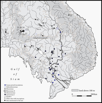
Map showing the location of early historic inscriptions citing where possible the ruler in question, and sites mentioned in the text. 1. Oc Eo, 2. Angkor Borei, 3. Wat Luang Kao, 4. Isanapura (Sambor Prei Kuk), 5. Thala Borivat, 6. Banteay Prei Nokor, 7. Prasat Phumpon, 8. Phum Snay, 9. Prei Khmeng, 10. Lovea, 11. Phimai, Ban Suai, 12. Wat Sa Kaeo, 13. Wat Ban Song Puay, 14. Phanom Wan, 15. Non Dua, 16. Ban Chiang Hian, 17. Muang Sema, 18. Don Khum Ngoen, 19. Ban Kaeng Toi, 20. Non Pa Wai, 21. Nil Kham Haeng, 22. Sepon, 23. Non Ban Jak, 24. Noen U-Loke 25. Non Muang Kao, 26. Ban Non Wat, 27. Ban Prasat

Appreciating the profound social changes that occurred is encapsulated in a comparison between the early Iron Age cemetery at Ban Non Wat (26 in fig. 2) in the Upper Mun Valley of northeast Thailand and the establishment of a state centre at Sresthapura near the confluence of the Mun and Mekong rivers. Excavations at the former, which dates from about 420 BCE, revealed 143 early Iron Age burials with no unusual mortuary wealth nor evidence for a relatively differentiated social order.Footnote 2 Less than a millennium later a magnate with the resounding Sanskrit name of Devanika, a great king of kings, established a city at Sresthapura. I will first summarise what is known of this and other early states of the southern part of the Khorat Plateau and adjacent regions of Laos and Cambodia, before turning to the prehistoric record to propose an explanatory model for the rapid social changes that took place.
The early historic period
The earliest state-like polities in Southeast Asia concentrate in coastal regions that had early access to the seaborne trade routes that linked them with India and China. That which occupied the Mekong Delta is known from Chinese records as Funan, and it was already flourishing when visited by a Chinese delegation in the third century CE.Footnote 3 The archaeological record for Funan incorporates large cities, such as Oc Eo and Angkor Borei (1 and 2 in fig. 2), linking canals, and a handful of inscriptions that mention kings and queens with Sanskrit names (fig. 2). Situated athwart the lower reaches of the Mekong River, it commanded ready access to the interior of Southeast Asia. This article is restricted to the interior region, for the importance of this route is evidenced in the establishment of a second early state where the Mekong has its confluence with the Mun River system to the west, and a series of other rivers that flow westward from the Truong Son Cordillera. It was here that inscription K.365 discovered at Wat Luang Kao (3 in fig. 2) records the presence of the exalted king Sri Devanika at Lingapura.Footnote 4 The style of the script places this text in the sixth century CE. Michel Lorrillard, noting the architectural evidence that survives at this site, has described it as an ancient city comparable to Sambor Prei Kuk, the pre-eminent urban complex of Pre-Angkorian Cambodia that dates to the late sixth and early seventh centuries CE.Footnote 5
Archaeological research in this inland region centred on Wat Luang Kao is reporting an increasing number of sites, mostly on the basis of the bricks and lintels of severely disturbed sacred structures and associated reservoirs. Lorrillard has described, for example, 24 Pre-Angkorian sites on the Champassak Plain, while the Se Kong Valley also contained a series of sites dated, on the basis of the style and content of the lintels, to at least the seventh century.Footnote 6 Clearly, there had been an early adoption of Hindu deities expressed through sacred temple structures.
This nodal confluence between the Mekong and the Mun rivers seems to have attracted the attention of a member of an elite, royal lineage with the Sanskrit name Mahendravarman. He was the younger brother of Bhavavarman, who was active in 598 CE, when he was named in inscription K.151. The brothers were the sons of Viravarman and grandsons of Sarvabhauma, so their ancestry must go back well into the sixth century. Mahendravarman recorded on a series of inscriptions, a military foray up the course of the Mun River Valley. Territorial gain is a widespread hallmark of early states, and what he encountered there is still, to a certain extent, open to speculation. We do, however, know of impressive brick shrines dedicated to indigenous and Indian gods. This is seen for example at Prasat Phumpon (7 in fig. 2), north of the Dang Raek escarpment in the Mun catchment by the second half of the seventh century.Footnote 7 Excavations beside the central Angkorian temple at Phimai (11 in fig. 2) encountered an earlier, brick structure.Footnote 8 Brick structures and sandstone lintels are known from Wat Sa Kaeo in Amphoe Phibun, Ubon Ratchathani province (12 in fig. 2), where inscription K.1096 mentions a King Nrpendradhitpativarman. Further evidence for Pre-Angkorian settlement is seen at Ban Kaeng Toi (19 in fig. 2) in Ubon Ratchathani, and Don Khum Ngoen (18 in fig. 2) in Roi Et province.
The thread of archaeological evidence for early states in the Mun Valley is supported by the surviving texts.Footnote 9 Inscription K.388 mentions Nrpendradhitpativarman ruling a city called Sro Vraah, as well as other kings named Sauryavarman and Indravarman, and a capital named Tamran. K.404 mentions King Jayasinhavarman, while K.1082 from Wat Ban Song Puay (13 in fig. 2) mentions a King Paravarasena and a capital named Sankhapura. An eighth-century text from Phimai, K.1000, mentions King Sauryavarman, a person who may have been connected to a state of the Upper Mun Valley known as Sri Canasapura. The Bo Ika inscription (K.400) from Muang Sema (17 in fig. 2), a large urban centre near Nakhon Ratchasima, also mentions this polity.
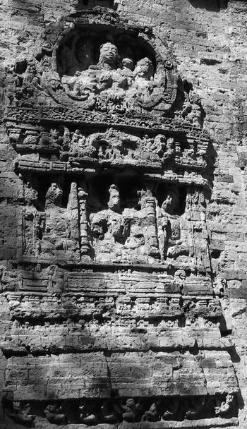
This epigraphic record is threadbare when compared with that south of the Dang Raek range, where in northern Cambodia, early state sites known collectively as Zhenla (Chenla) after Chinese accounts, dating between at least 550 CE until the foundation of Angkor in about 800 CE, are more plentiful. Archaeologically, the best known is Sambor Prei Kuk, ancient Isanapura (4 in fig. 2). Here, three walled sacred precincts contain one-chambered brick shrines dedicated to Siva, and dating to the early seventh century. Exterior walls were decorated with scenes that included palace buildings with rulers and their entourages (fig. 3).
The depiction of a palace scene from Sambor Prei Kuk, ancient Isanapura, of the early seventh century CE

Viewed from the air, it can be seen that this central cluster of buildings lay within a walled city 2 by 2 km square that commanded an external reservoir. Ichita Shimoda has identified rice field boundaries next to the city, while Scott Hawken has mapped rice fields around temples of the Zhenla period north of the Tonle Sap.Footnote 10 Some insight into the court centres of Zhenla in the early seventh century is provided by an account attributed to the thirteenth-century chronicler Ma Duanlin, which described a king giving audiences in a great hall, wearing a crown of gold and precious stones and seated on a wooden throne. He was accompanied by five officials of state and protected by armed guards.Footnote 11
Rather than a unified Zhenla kingdom, there appears to have been a constellation of small states, each with an elite centre that waxed and waned, due no doubt to multiple causes. These might have included the charisma and political aptitude of their leader, natural catastrophes such as failure of the monsoon rains, or conquest by more powerful polities. There is thus a concentration of sites in the vicinity of the future Angkor, and another at Banteay Prei Nokor east of the Mekong River (6 in fig. 2). Further north, there is a further politically active centre in the region of Thala Borivat (5 in fig. 2). Michael Vickery has provided the seminal analysis of the corpus of Zhenla inscriptions, which provides a social overlay to the archaeological remains so comprehensively catalogued by Henri Parmentier and his successors.Footnote 12
These inscriptions describe at the social apex, generations of hereditary kings with Sanskrit names. Over time, the titles became increasingly grandiose such that by the reign of Jayavarman 1 of Isanapura (c.635–80 CE), we encounter for the first time a living king accorded a divine title. Lesser members of the elite in the century until about 720 CE were often given the title pon. These are usually cast in the role of vassal aristocrats who administered their own region that was centred on a temple. They are recorded arranging the construction and maintenance of reservoirs, and fulfilling the temple's economic function through the storage and deployment of surplus production of rice, cloth, domestic stock and other desirable commodities. The majority of the population retained Khmer names, and served the pon through work in the rice fields, as well as working as leaf stitchers, ironsmiths, cooks, weavers, spinners, herdsmen, perfume grinders and temple dancers. Land could be purchased and privately owned, and the social elite tightly controlled labour. We read of the need to fix land boundaries, a means of ensuring that landholdings could be identified and if possible through purchase, lead to increased private wealth.
It is suggested therefore, that northern Cambodia, southern Laos and the Mun Valley in Thailand shared a common transition into early states that began no later than the fifth century CE and continued through increasing complexity until the foundation of the Kingdom of Angkor.Footnote 13 This expression is more muted in the Mun Valley than the other two regions, but it is still evidenced through inscriptions and surviving temples. Identifying the origins of these states turns on the evidence drawn from the preceding prehistoric Iron Age.
The prehistoric period
There is an imbalance between the concentration of historic sites south of the Dang Raek escarpment, and the density of and investigations into Iron Age settlements to the north, in the Mun River Valley. However, as research into the later prehistoric period in northern Cambodia gathers pace, it is increasingly evident that the Iron Age occupants north and south of the Dang Raek Range shared a common cultural tradition. There are large moated settlements in each region, within which the dead were interred with similar mortuary rituals. There are marked parallels in the bronze and iron artefacts, and exotic hard stone and glass ornaments. Even the forms and finish of ceramic vessels at Phum Snay and Prei Khmeng (8, 9 in fig. 2) in the Phimai Black tradition of the Mun Valley are matched in northwestern Cambodia. The Dang Raek range then and now is porous, with many well-worn exchange routes. On both sides, the land has little elevation, is crossed by many tributary streams, and they share a similar monsoonal climate with a long dry season, and heavy rains between April and October. Currently available evidence suggests that cultural changes detected north and south of the Dang Raek range occurred in tandem.
The Mun Valley was densely occupied during the Iron Age. The archaeological record is dominated by mounded settlements surrounded by multiple moats demarcated by banks. Glen Scott has listed 297 such sites, ranging in size from 0.5 to 171 ha. Half the sites vary in area between 6.2 and 19.7 ha with an average of 15.9 ha.Footnote 14 They are most densely concentrated in the drier western part of the Mun Valley, and were located in the vicinity of the streams that fed water into the moats. Some are located so close to each other as to be intervisible; 1.8 km separate Noen U-Loke from Ban Non Wat (26 in fig. 2). John Parry has suggested on the basis of remote sensing, that they were linked with extramural dams and canals to control the distribution of water.Footnote 15 This is seen at Ban Chiang Hian (16 in fig. 2) in the Chi catchment, as well as Non Dua (15 in fig. 2), Non Muang Kao (25 in fig. 2) and Noen U-Loke (fig. 4). The small and steeply-sided mounds that cluster round many moated settlements accumulated through the production of salt. To this day, salt production is a major dry season activity, the villages accumulating the salty topsoil before processing it as in prehistory, by filtering water through the soil to produce brine, which is then boiled to leave the salt.Footnote 16 The vital importance of salt lies in preserving wet season surpluses of fish for dry season consumption. There are also unmoated Iron Age settlements, some of which are recognised by the large accumulation of iron slag, and clear evidence for iron smithing in the moated sites. Although Oliver Pryce and Surapol Natapintu have pointed out that some of the local laterite ore is not suited for iron smelting, the presence of so many prehistoric sites now named Ban Khi Lek (iron slag village) suggests that some local iron ores were exploited in prehistory.Footnote 17
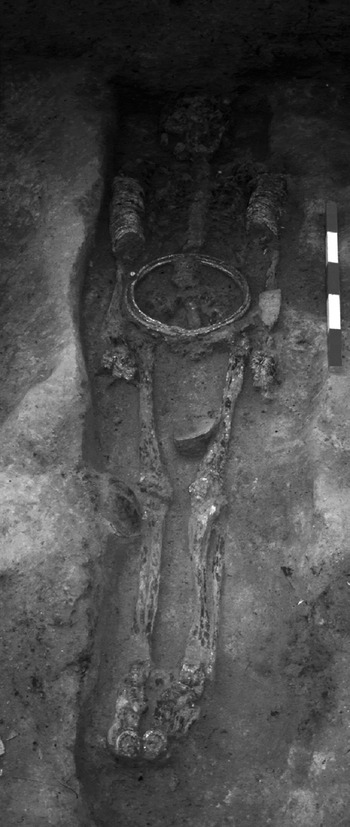
Burial 14 from Noen U-Loke, the richest Iron Age male identified in the Upper Mun Valley

The Mun Valley thus incorporates two important resources, iron and salt, and the Iron Age settlements were located in relatively flat terrain suited to the cultivation of rice. But it is also a natural trade conduit. To the west, a pass over the Petchabun Range leads to central Thailand, with its sources of copper and tin, and early access to the later first millennium BCE seaborne exchange with India and beyond. In the east, it joins the Mekong River routes to the south. Although less favourably placed than coastal communities, there was still the potential to participate in the new opportunities for exchange and enrichment as the maritime trade grew.
Very few of the 297 sites listed by Scott have been opened by excavation, and in the majority of cases, the area opened was too small to provide meaningful social information. The largest area revealed, at the site of Ban Non Wat, represents about 5 per cent of the site's area, and involved ten seasons of excavations totalling over two years in the field. We are therefore in the early stage of illuminating the cultural sequence and its integration with the early historic period.
In the Upper Mun Valley, Ban Prasat (27 in fig. 2) is better known for the rich early Bronze Age burials than the few Iron Age graves above them.Footnote 18 The latter include one individual interred with an unusual bronze head ornament. Phimai (11 in fig. 2) was the major centre of the Angkorian period in this region, and its local dynasty of Mahidharapura engineered under Jayavarman VI, a coup that gave Angkor its two greatest rulers, Suryavarman II and Jayavarman VII. A mound partly within the enclosure of the Angkorian city has been excavated on two occasions, most recently by the Fine Arts Department. It was built up during the later Iron Age, when the distinctive Phimai Black ceramic ware was in vogue. Modern housing rules out an areal excavation of what has the potential to be a key site in the transition under review, and the 2001 excavation covered 8 by 8 m.Footnote 19 However, prehistoric occupation over at least five centuries preceded the construction of the brick temple that underlies the central Angkorian sanctuary. All the characteristics of the later Iron Age seen from more extensive excavations are present. There are inhumation burials of adults and infants, with bronze ornaments and ceramic grave goods. Spinning and weaving is seen in the many spindle whorls and fabric impressions, and iron smithing took place. There are also clay floors and pits containing complete pottery vessels of the Phimai Black tradition. A link between the late prehistory and the early historic period in the Upper Mun Valley is also seen at the Angkorian site of Phanom Wan (14 in fig. 2), where Iron Age burials were laid out on the same orientation as the main temple.
Identifying and tracing the cultural changes during the phases of the Iron Age is currently best done from excavations at four other sites in close proximity to each other. Noen U-Loke has the longest sequence, divided into four phases described below as IA 1–4. Three of these are represented at Ban Non Wat, IA1 having the largest sample of burials, while IA3 and 4 are not well documented at this site. A small excavation at Non Muang Kao revealed occupation during IA4, while at Non Ban Jak, occupation began in IA 4, the sequence of burials being divisible into four sub-phases, IA 4a–d.
The chronology and cultural sequence at Noen U-Loke has been described in detail and will only be summarised.Footnote 20 The four mortuary phases cover a millennium. Just six burials represent IA1 dated between 400–100 BCE, but they already reveal how iron was deployed. One man was interred with a large socketed iron spear and a hoe, while a woman wore iron bangles and a torc. Bronzes were impressive, the richest male wore four bronze torcs or neck rings, as well as a bangle, together with two bronze spears. Four pierced tiger's canine teeth had been worn as a necklace. The man in the adjacent grave wore two pierced boar's tusks.
The ceramic vessels from these IA1 graves are virtual carbon copies of those found in the corresponding period at Ban Non Wat, just 1.8 km to the east. However, at the latter site, the large sample comprises men, women, children and infants, disposed in two groups with one having the head oriented to the north, the other to the south. This cemetery was contiguous with that of the Late Bronze Age, making it possible to pinpoint the changes that occurred with the adoption of iron technology. Dating from the late fifth century BCE, the first use of iron, as at Noen U-Loke, involved the forging of heavy socketed spears and hoes, as well as bangles.Footnote 21 The large sample size expanded the list of iron to include kits of knives and awls, as well as bimetallic spears, where a bronze haft was welded onto an iron blade. A significant finding from this cemetery, again probably reflecting the large number of burials uncovered, is the rare inclusion of glass ear ornaments, and carnelian and agate beads. All three beyond reasonable doubt point to the impact of Indian trade, and it is reasonable to suppose that knowledge of iron, being contemporary with this exotic jewellery, reached the Mun Valley in a similar manner either from central Thailand or possibly by the Mekong route.
There are similarities and other innovations when comparing these burials with those of the immediately preceding Bronze Age. The form of the ceramic vessels was virtually unchanged. Some individuals continued to be interred with spindle whorls and grey clay indicating a weaving industry. However, the bronze casting technology now included lost wax castings, and bronzes were more abundant. Articulated water buffalo bones were placed with the dead, along with pig and cattle bones and many complete fish. Mortuary feasting is a known means to advertise social status, but a statistical analysis of the IA1 burials from Ban Non Wat has not identified unusually wealthy individuals or groups. The IA1 burials at Ban Non Wat are densely grouped. The disposition of broken ceramic vessels suggests interment in wooden tree trunk coffins cheek by jowl with the neighbours, converting in an easterly direction into deeply excavated individual graves. There is no evidence for residential structures, although in the eastern part of the excavated area, very disturbed floors were identified. It is suggested that this was a dedicated cemetery, rather than a residential quarter where the dead were interred within houses.
IA2 (c.100 BCE–200 CE) is represented at Noen U-Loke by two clusters of burials. The earlier comprised six graves, in which mortuary offerings included the first recorded glass and agate ornaments at this site. The later cluster displayed several innovations. The dead were now interred in graves filled with rice. There was an impressive collection of carnelian as well as agate and glass jewellery, but no iron, and hardly any ceramic vessels. Bronzes included finger and toe rings, and one man had a large spiral bronze ornament on the side of his cranium. It is also noted that one grave had been cut through a burnt clay floor, the latter also sealing the cluster of burials below it. The cluster thus seems to have been associated with a structure of some sort, though its function has not been ascertained due to its generally disturbed environs.
With IA3 (200–400 CE), we come close chronologically to the period of state formation seen downstream at the early urban centre of Lingapura (sometimes also known as Sresthapura). Significantly perhaps, there was a further sharp change in the mortuary rituals, seen particularly in a marked increase in the energy expended. Again at Noen U-Loke, there was tight clustering of interments, four being identified in the area excavated. These contained the graves of men, women, infants and children. The dead continued to be buried in rice-filled graves. This even applied to some infants, whose remains were found in ceramic vessels filled with rice grains. One of the key points of this phase, is the presence of some outstandingly wealthy individuals, in terms of mortuary offerings as well as an overall increase in the quantity of grave goods. The richest of all was a man, interred wearing multiple bronzes: three belts, a hundred and fifty bangles, sixty-one finger rings, six finger spirals and two toe rings (fig. 4). Apart from the eight ceramic vessels, he was also accompanied by an iron knife, gold and silver discs that had been inserted into each ear lobe, two agate pendants, two bimetallic bronze and iron rings and multiple glass beads. An adjacent infant was also well endowed with offerings that included the customary rice, two agate pendants, bronze bangles and glass beads.
Two clusters of IA3 graves retained clay capping to the coffin. One woman wore a necklace of sixty-eight gold and thirty agate beads, and multiple bronzes including thirty-eight bangles, sixty-four finger rings, nine toe rings, and two ear spiral inserts. The cranium was found hard up against the edge of the excavated area, and there may well be more than the four recovered black ceramic vessels. This woman also wore two silver rings, one on the hand and the other on the foot. Seven pots and forty bronze bangles accompanied an infant in this group.
IA3 Cluster C contained a man with four bronze belts as well as a hundred and twenty-four finger rings, thirty-three toe rings, twenty bangles, four bimetallic rings and two bronze ear discs. A woman in the same group was also rich in terms of bronzes, but arguably the most significant offering found in this group was a socketed iron implement formerly identified as a spade, but now reinterpreted as a ploughshare. The fourth cluster was dominated by the central grave of a woman who had died after receiving several savage cutting blows to the head. This group was not as wealthy as the others, the murdered woman having eleven bronze bangles, two finger rings, sixteen earrings, and four spindle whorls.
The layout of this IA3 cemetery attracts attention by the sharp clustering of grave groups. In the absence of any hint of associated structures, other than the clay coffins, each cluster is seen as representing groups of related individuals in essentially family plots. The sharp rise in the wealth of at least three of the four groups strongly suggests that at this period, aggrandisers in the Noen U-Loke community were employing mortuary rites to express their high social standing.
Three sites in the Upper Mun Valley have provided information on IA4, the final phase of the Iron Age, which is dated from about 400–600 CE. Non Muang Kao is a large double-mounded site which has so far only been examined through a small exposure of 5 by 5 m.Footnote 22 This site was the first in the region to reveal clear evidence for structural remains in association with human burials. Superimposed floors were uncovered, through which graves had been cut on a north to south orientation. These floors also were severed when lidded ceramic vessels were placed, presumably for ritual purposes. The excavated area was too small to configure the plans of rooms, or residences, but the very conjunction of graves with structural remains suggested the possibility of residential burial.
The IA4 cemetery at Noen U-Loke, approximately contemporary with the exposure at Non Muang Kao, saw an end to the tight clustering of burials in favour of what look like two rows of dispersed graves. No floors or walls seen at Non Muang Kao were identified during the excavation. Rice no longer filled the graves, and the quantity and range of mortuary offerings differed. There were far fewer bronzes, but iron sickles were regularly encountered. The richest grave was that of a man who wore fifty-nine bronze rings, twenty-two bangles and four bimetallic rings. Another man in a disturbed burial was buried with fifty-three gold beads. A third man, interred prone, died when an iron arrowhead severed his spinal column. Conflict was clearly in evidence, also seen at this juncture in the rise in iron points from occupation contexts, and the interment of an iron spear with one male in the IA4 cemetery.
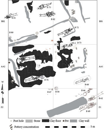
The double-peaked moated site of Non Ban Jak lies 8 km to the west.Footnote 23 In both parts of the site so far excavated, initial settlement took place during IA4. Radiocarbon determinations on rice grains recovered from an early kitchen on the eastern mound fall in the fifth century CE. The IA4 cemetery in the western mound has been divided on the basis of the stratigraphic sequence into four sub-phases that cover the fourth to the eighth centuries CE. In the earliest, the burials were relatively poor, with no associated structural remains. During IA4b–c, there was a marked change. Individuals were relatively wealthier, but never reaching the heights seen during IA3 at Noen U-Loke. But there is no doubt that the dead were now being interred in residential contexts.Footnote 24 One room in a building on the eastern mound contained the graves of an adult, child and an infant. Lidded ceramic vessels had been placed in three of the four corners of this room, exactly 3.8 m apart. The fourth corner had been disturbed in antiquity. Superimposing the walls and floors of IA4c graves in the western quarter shows the graves cut through clay floors, always on the same orientation as the buildings in which they lay. Floors also cover IA4b burials below (fig. 5). Interment in houses during this late Iron Age phase contrasts markedly with the clusters of burials seen at Noen U-Loke during the preceding phases.
The plan of the Iron Age 4c burials at Non Ban Jak, showing their relationships with residential floors and walls

On the eastern mound, the earliest house, which had an infant interred in a central location in one of the rooms, overlay a ceramic kiln still retaining six pottery vessels. It has been enclosed with a clay dome to fire the pots under reducing conditions. A second socketed iron ploughshare, with a wing fractured in antiquity, lay among the pots. It might have been placed there to heat it prior to re-forging. Such weighty objects are not likely to survive, since the iron could have been recycled. The implications of ploughing and residential burial are two new factors emerging from the excavations at Non Ban Jak that will be considered in more detail below.
The rich mortuary record furnished from excavations in the Upper Mun sites assumes greater relevance and clarity when it is considered in conjunction with related information. Foremost is the date and the purpose of the moats that encircle so many of the Iron Age mounded settlements. In their investigations into these moats, William Boyd and William McGrath first reconstructed the former drainage pattern in this relatively flat terrain, and found that the settlement locations were closely related to the courses of former streams most of which have since moved their courses or dried up.Footnote 25 The moats themselves are impressive structures in their own right. The five at Noen U-Loke extend up to 200 m from the margins of the mound. Excavation of trenches across these moats and banks at five sites, including those discussed above, has shown that they were constructed by piling soil into the banks, rather than deep excavation into the substrate. They were thus flat bottomed rather than have a V-shaped profile through deep digging. The radiocarbon determinations taken from charcoal and rice within the banks and channels reveal that the moats at Ban Non Wat place the construction period in IA3, that is the very period of the richest burials at Noen U-Loke. Two AMS dates on charcoal from buried channels at the edge of the mound at Noen U-Loke itself places their use within the periods 87 BCE–114 CE and 81–339 CE while rice grains from the sediment in the first visible moat suggest that the site was occupied and the moats were functioning within the spans 405–600 CE and 453–798 CE respectively. The range of 14C determinations for Non Ban Jak fall between 263–559 CE, again corresponding to occupation during IA4.
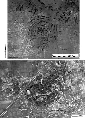
The moats and banks are not the only extramural earthworks associated with these Iron Age settlements. At Noen U-Loke a linear feature emanates from the eastern outer moat and links the site with a stream to the south. Linear embankments are visible on aerial photos of Non Muang Kao, again aligned with and linked to the moats (fig. 6). John Parry has suggested that a reservoir, dam and distribution canals combined with the moats at Ban Chiang Hian in the Chi River catchment were components of a water capture and distribution system.Footnote 26 The large moated site of Non Dua in Roi Et province lies adjacent to a salt resource. A canal links the moats with the river to the south of the site. Perhaps the most significant recent advance in understanding the archaeology of water distribution during the Iron Age, however, comes from the area northwest of Angkor. Lovea has long been known as a moated site in this region, and recent excavations by Dougald O'Reilly have uncovered an Iron Age cemetery (see O'Reilly and Shewan, this vol.). On the basis of remote sensing, Hawken has identified banks radiating out from this site, which he has interpreted as prehistoric bunded rice fields.Footnote 27 There are several other, similar configurations of radial banks in the same area, which may also have been associated with Iron Age sites.
Aerial views of Noen U-Loke (top) and Non Muang Kao, two of the excavated sites in the Upper Mun Valley (© Government of Thailand). Note in particular, the earthworks beyond the encircling moats, which might have been constructed to distribute water from the moats

The earliest structure on the eastern mound at Non Ban Jak suffered a conflagration which baked hard the clay floor and preserved pottery vessels over a hearth, together with large concentrations of carbonised rice. In her analysis of this rice, Cristina Castillo has identified wetland weed seeds in some contexts.Footnote 28 Turning to the shellfish identified from the Iron Age occupation contexts at Noen U-Loke, Morag McCaw noted a sharp change in the relative frequencies of two freshwater gastropods in the later Iron Age, when Pila ampullacea grew in frequency at the expense of Filopaludina.Footnote 29 The former is particularly adapted to rice fields, and harmonises in terms of the site's sequence, with the presence of rice in burials, the presence of a ploughshare, and rich individuals in the IA3 cemetery. At Ban Non Wat, Nigel Chang has reported an area at the western edge of the site bearing a palimpsest of the imprints of cattle and water buffalo hoof impressions.Footnote 30 It is considered highly likely that these represent a pound for protecting domestic stock against theft or predators. It hardly needs emphasis that both cattle and water buffalo could have been valued for their tractive power in pulling a plough.
Taken singly, these innovations might not be seen as symptomatic of any significant behavioural changes, but when considered in conjunction, each contributes to a model for an economic revolution with powerful social implications. In his treatise on social inequality, Jean-Jacques Rousseau famously concluded that ‘The true founder of civil society was the first man who, having enclosed a piece of land, thought of saying “this is mine”, and came across people simple enough to believe him.’Footnote 31 This prescient sentence resonates with the new evidence for Iron Age rice cultivation, for the very essence of bunded and probably irrigated land is that it is parcelled, defined, and improved. Ownership is the key to social advancement. The revolution in the Late Iron Age thus involved first, the building of infrastructure — the multiple banks round the sites to control water, the canals and, if the Lovea rice bunds are indeed of Iron Age date, the parcelling of land. Bunded fields retain rainwater, which can then be allowed to percolate through adjacent plots. Rice, being an aquatic grass, flourishes when there is a ready supply of blue-green algae. One of the constraints to rice cultivation, particularly during a period of increasing aridity that is documented for the Iron Age, is an unpredictable monsoon. If rainfall faltered, then water stored in the moats could have been reticulated into the rice fields.
As Jack Goody has stressed in considering agricultural practices in Africa and the Near East, ploughing when compared with hoe cultivation can increase the area a single man can bring into production tenfold.Footnote 32 The Iron Age sequence in the Upper Mun Valley began with the forging of iron hoes, and ended with ploughshares and sickles. The weight of iron in a ploughshare makes it a prime target for recycling when broken or worn out. The two that have survived came fortuitously, one with a burial and the other from within a ceramic kiln. They are a critical key to the model for an agricultural revolution in the later Iron Age, a period when rice is abundantly represented. A kitchen floor at Non Ban Jak was covered in carbonised grains. At Noen U-Loke, the dead were interred in graves filled with it. Rice grains adhere to the iron sickles and knives in graves at Non Ban Jak. Rice is a source of wealth. It can be stored, and traded, and used in rites of passage, such as mortuary feasts to project and augment status. Ownership of the tractive power of the water buffalo would also have given leverage to social standing.
The later Iron Age was a period when increasing quantities of exotic valuables were moving along exchange routes. The bronzes, for example, worn by just one Iron Age man at Noen U-Loke rival the weight of the entire known corpus of ornaments recovered from the Bronze Age dead in Southeast Asia. Moreover, the evidence for copper production at the Khao Wong Prachan Valley sites of Nil Kham Haeng and Non Pa Wai (20, 21 in fig. 2) surged at this period.Footnote 33 To the east, the copper deposits at Sepon in Laos were also being exploited (22 in fig. 2). The quantities of glass greatly increased as the Iron Age progressed, as did agate and carnelian jewellery. With IA3, we also encounter the first use of gold and silver. Preferential and restricted access to these traded materials is symptomatic of the rise of aggrandising social elites. And this introduces the recent identification of residential burial practices during IA4 at Non Muang Kao and Non Ban Jak.
As Ron Adams and Stacie King have emphasised, residential burial links the living with the ancestors, and provides the social context for group identity.Footnote 34 It reinforces inherited rights to property, wealth and status by the members of the kin group in question. The transition from interment in a dedicated cemetery to burial within the house might seem subtle, but as Nicola Laneri has shown for Mesopotamia during the late third and early second millennia BCE, the establishment of house burial took place at a time of marked economic change.Footnote 35 Thus, the rise of merchant and entrepreneurial lineages at that juncture involved the formation of powerful households that disposed of increased wealth and social standing. At Titriş Höyük, the development of residential tombs took place as wine production and exchange for exotic valuables enabled competing merchant households to gain in social prestige and wealth. It is argued that as in Mesopotamia, so in northeast Thailand, a change in mortuary practice occurred in tandem with fundamental economic changes involving kin ownership of improved land, the organisation of labour, and preferred access to exotic valuables.
It must be asked in this context, what was being produced locally to feed into the exchange networks that formed the social sinews of the later Iron Age? The Upper Mun town sites coincide with small, steeply-sided mounds covered today in coarse ceramics. Those excavated provide evidence for the production of salt.Footnote 36 This continues to this day to be a major industry in the region, and is an essential ingredient of the fermented fish that is processed from wet season surpluses to sustain communities during the long dry months. It is widely traded. The Iron Age settlements were also hives of industry. There is recurrent evidence for iron smithing, bronze casting, pottery making, and the production of yarn for weaving. Doubtless other productive activities took place without leaving an archaeological signature.
Given the evidence for the establishment of new settlements in the later Iron Age at sites like Non Ban Jak and Non Muang Kao, and the sheer number of moated sites, it is not surprising to encounter evidence for conflict. The moats and banks could have fulfilled a defensive as well as an economic function, and the interment of iron weaponry, proliferation of iron points, not to mention the arrowhead embedded in a young man's spine, suggest that the Upper Mun Valley was not peaceful. The human remains at Phum Snay in Cambodia, as well as the iron weaponry at that and related sites, suggest that conflict there was if anything more marked than in the Mun region.Footnote 37 Military expeditions, as described in the inscriptions of Mahendravarman in the late sixth century, certainly exacerbated aggressive relationships in the Mun Valley.
Conclusions
Despite the disjunction between the sources for the Late Iron Age and the early historic period, it is argued that the two dovetail neatly into a pattern of cultural continuity and rapid social change. This argument begins with two assumptions that are progressively being confirmed. The first is that the Iron Age communities north and south of the Dang Raek Range comprise a cultural continuity. These were closely related communities, with a similar trajectory of economic and social changes during the vital first five centuries CE. The second is that, although the early historic states of Zhenla had their epicentres in strategic locations in northern Cambodia and southern Laos, there were probably similar rulers in the Mun Valley. These linked regions are thus the component parts of a broad expanse of territory within which agrarian early states rapidly crystallised by the fifth and sixth centuries CE.
Kent Flannery and Joyce Marcus have employed ethnographic instances of early state formation to stress the role of agents, people of charismatic influence and ambition.Footnote 38 A checklist of instructions to the would-be aggrandiser includes the organisation of labour, attraction of followers, territorial expansion over rivals, an increase in production to provide surpluses, extravagant rituals involving feasting and gifting, changes in ideology to identify with ancestors and innovations in warfare. For Norman Yoffee, seeking evidence for power is seminal, reflected archaeologically in the presence of differentially large residences, specialised activity areas, elite burials and community temples.Footnote 39
Identifying aggrandising agents on the basis of prehistoric evidence is not foolproof, but the presence of immensely wealthy men and women at Noen U-Loke is a pointer to their presence. Other items on the checklist can be ticked off: surplus production of rice, potential of private ownership of land and warfare. Morphing into the early historic period of Zhenla, we find an expansion of water control measures, endemic expansionary warfare, charismatic leaders with Sanskrit names, the placing of kinsmen over conquered territory, a change in ideology to embrace Hindu gods and the construction of community temples. We encounter a social organisation with a vrah kamraten an at its apex. This Khmer title may be translated as ruler, or king, but it was also applied to gods, suggesting that by the time of Jayavarman I, the king was at least semi-divine. The walls of Isanapura (4 in fig. 2) temples may depict such exalted rulers (fig. 6).
The Zhenla inscriptions record community leaders entitled pon, who oversaw the redistribution of surpluses through the temple, and organised water control and distribution measures. Judith Jacob has described how rice fields were often demarcated by reference to reservoirs.Footnote 40 Land was privately owned, and often donated to the temple by the owner. Cloth, rice and silver were used in payment for land. Separate rice fields are sometimes described as part of the same transaction, suggesting that they were clearly separate and demarcated. Land was also of variable quality, for K.79 describes two parcels of land of the same capacity but priced in different quantities of cloth. Expressions describing agricultural activities include low ground, pasture, and an enclosure for animals. The inscriptions leave no doubt as to the class divide that now characterised Zhenla society, with words ranging from the palace to quarters for the lower classes. Names of the exalted were in Sanskrit, the ordinary workers had a wide range of often disrespectful Khmer names. The texts describe lower-class field workers, spinners, iron smiths, herdsmen, dancers and musicians.
It is suggested that many of these activities illuminated by the inscriptions are mirrored in the Iron Age archaeological record. An enclosure for domestic cattle and water buffaloes has been found at Ban Non Wat. The wealthy individuals buried contemporaneously with the construction of reservoirs suggest that water reticulation was directed by an emerging elite. Land demarcated into rice fields has been identified at Lovea (10 in fig. 2) and other Iron Age sites near Angkor. Cloth was woven, rice surpluses deployed ritually, and iron smiths were active. Given this integration between the two periods based on tangible evidence, is it not perhaps also possible to retrodict aspects of Iron Age beliefs and inheritance rules from the early historic texts? This has previously been noted by Michael Vickery when he suggested that ‘the concept of local protective gods of the earth, existed, probably from prehistoric times as part of native Khmer or Mon-Khmer religion’.Footnote 41 He has drawn attention to the popularity of representations of Durga slaying the demon buffalo in the seventh century, and pointed to buffalo sacrifice as a possible reason for this. Prehistoric butchering floors, possibly associated with provisioning mortuary feasts, contain the remains of water buffaloes. Other indigenous deities mentioned in inscriptions also, surely, had prehistoric roots, although much caution must be exercised in the interpretation of the relevant inscriptions.Footnote 42 There is a god of the road, a god of the clouds, and a god of the west. Vickery suggests that these were protective spirits, possibly also lineage-related deities. Clearly the prehistoric mortuary rites were laced with reference to the spirit world and the ancestors. Vickery has also described the importance of kinship links through females, a fact that should not surprise, given the wealth of some women at Noen U-Loke, and their interment at Non Ban Jak in the same residential precincts as men.Footnote 43 The transition from late prehistory into the early Zhenla states north and south of the Dang Raek Range can thus not only illuminate the roots of the latter, but also intangible characteristics of the former.