The horse's introduction into the Northwestern Plains of North America during the early eighteenth century dramatically affected the lives of the Blackfoot people. While others have studied the socioeconomic consequences of the horse, the objective of this work is to understand how this equestrian shift altered the relationship between the Blackfoot and their landscape, particularly the criteria used in the selection of habitation sites. The character of Blackfoot seasonal and territorial movements changed in two ways following the adoption of horse husbandry. First, the horse introduced speed, traction, and transport, which in turn disrupted not only mobility patterns but also traditional hunting methods, as people could now move about their landscape in ways they had never before experienced. Second, as the horse became an indispensable component of the bison hunt, it quickly developed into a source of wealth accumulation and prestige as well as a valuable item in ritual, social reciprocity, and long-distance trade. The accumulation of horses thus gained primacy in Blackfoot life as the animals took on an intrinsic value beyond their instrumental worth in hunting, traction, and transportation. The new demands of horse husbandry in turn required a reconceptualization of traditional land use as attention shifted from a focus on large-scale communal hunting efforts to a system devoted to the maintenance and growth of horse herds (Ewers Reference Ewers1955; Landals Reference Landals, Kelley and Kooyman2004). This work argues that these two realities combined to transform the Blackfoot worldview from a “hunter-gatherer landscape,” where mobility and settlement patterns were determined by the needs of hunters, to a “pastoralist landscape,” in which the needs of horses dictated how, when, and where the Blackfoot interacted with and moved across their homeland.
While there are numerous ethnohistoric accounts of Blackfoot life, early reports of Blackfoot settlement patterns, primarily coming from Euroamerican travelers, trappers, and traders, afford only a peripheral view, since outsiders did not significantly penetrate the core of Blackfoot territory until after the 1830s, over one hundred years after the initial introduction of the horse (Tovias Reference Tovias2011). Whereas history sees traditional Blackfoot lives from the margins of their former territory, archaeology can provide a picture of Blackfoot landscape use within their own homeland. This project presents a new dimension to the dynamics of the equestrian transition by incorporating material culture with traditional knowledge, ethnohistory, and geospatial data into a multiscalar, transnational interpretation of the horse's impact on the way Blackfoot peoples used and understood their landscape.
Traditionally, archaeological investigation of the Contact period in this region has been limited almost exclusively to Euroamerican settlements or the analysis of trade materials from Native American sites. As a result, few archaeological studies have examined the indigenous experience of this time period. Admittedly, the study of the horse on Plains cultures is difficult because archaeologists have recovered almost no horse remains from sites in this region. This absence is likely due to several factors, including the traditional ways in which horses were treated postmortem by mobile Plains groups, which exposed the carcass to the elements and predators (Ewers Reference Ewers1955:285; Grinnell Reference Grinnell1962:97), nomadic encampments that leave a superficial archaeological record, and the destruction of many large, aggregated sites as a result of bone- and artifact-collecting activities that took place in the late nineteenth and early twentieth centuries. Due to this lack of material evidence, the Blackfoot–horse relationship has been largely understood from the ethnohistoric record. The key question, therefore, is, how can we understand the introduction of the horse if horses are essentially absent from the archaeological record? This work argues that we can answer this question at the landscape scale.
Blackfoot Land Use Systems from the Precontact to the Contact Period
Nomadic pastoralism is primarily a mobility strategy used in response to the environmental conditions needed to grow herds (Dyson-Hudson and Dyson-Hudson Reference Dyson-Hudson and Dyson-Hudson1980; Khazanov Reference Khazanov1994). Therefore, any discussions of this transition are integrally tied to conceptions of “landscape,” which, in its most general sense, entails a holistic framework for looking at the relationships between people, environments, land, and resources, both natural and cultural (Anschuetz et al. Reference Anschuetz, Wilshusen and Scheick2001; Bowser and Zedeño Reference Bowser and Zedeño2009; Scheiber and Clark Reference Scheiber and Clark2008). Change in land-use systems may result from both internal and external factors because, as systems respond to external change, so do a society's internal perceptions of landscape. Within mobile societies, these changes may subsequently place different values on variables required for habitation, as well as the timing and frequency of movements (Binford Reference Binford1982). Because the principles organizing a group's relationship to the landscape may differ significantly cross-culturally, we can address models of settlement and mobility from a perspective that is “uniquely tailored to their land use patterns, social networks, and political agencies” (Zedeño and Anderson Reference Zedeño and Anderson2010:10).
The Precontact Blackfoot were a seasonally mobile people organized in suprafamily bands that traveled on foot using dogs to transport their possessions. They focused their annual cycle of economic activities on hunting bison and processing storable and transportable by-products, such as pemmican and hides (Zedeño et al. Reference Zedeño, Ballenger and Murray2014). Ample evidence also shows that bison were at the core of belief systems, serving as an organizing principle of social, economic, and religious life (Ewers Reference Ewers1958; Grinnell Reference Grinnell1962; Schaeffer Reference Schaeffer1934; Schultz Reference Schultz1962).
The Blackfoot followed a seasonal round and, while its precise features are debated, most archaeologists agree that the movements of bison influenced the movements of human groups living in the Northwestern Plains, and, consequently, the location of all types of archaeological sites (Fisher and Roll Reference Fisher, Roll, Irby and Knight1998; Frison Reference Frison2004; Peck Reference Peck2004; Peck and Hudecek-Cuffe Reference Peck, Hudecek-Cuffe, Brink and Dormaar2003; Vickers Reference Vickers1991). Blackfoot residential groups probably did not directly follow bison herds, but instead developed knowledge of bison behavior to predict where bison would be and to manipulate herd movement through the judicious use of fire (Oetelaar Reference Oetelaar2014; Peck Reference Peck2004:112). Because bison movements predictably occur at the same season in the same place, human groups could reliably find bison in certain areas at specific times of the year, and thus would set up their hunting complexes and adjacent camps near these “intercept sites” (Bamforth Reference Bamforth1988; Barsh and Marlor Reference Barsh and Marlor2003; Brink Reference Brink2008; Hamilton et al. Reference Hamilton, Lobo, Rupley, Youn and West2014; Peck Reference Peck2004). The Blackfoot would have passed this knowledge down through the generations through rituals, such as bison-calling ceremonies and society bundles, and through communication with spirits associated with sacred places (Oetelaar and Oetelaar Reference Oetelaar and Oetelaar2006). Archaeological evidence suggests that the Blackfoot devoted a significant amount of time to the preparation and maintenance of communal hunting practices that involved the creation of systematic, landscape-scale hunting complexes consisting of drivelines, corrals, and other infrastructure (Zedeño et al. Reference Zedeño, Ballenger and Murray2014). These essential elements of bison hunting complexes linked the people, land, and resources in a built environment that imprinted practice and agency on the land, producing a habitual geography that sustained activities and shaped people's actions and decisions, ultimately creating a cumulatively engineered landscape (Zedeño et al. Reference Zedeño, Ballenger and Murray2014).
Major changes to this system occurred with the introduction of the horse and the development of mounted hunting techniques. The ability to harness the traction and transport power of horses to find, hunt, and haul bison significantly altered the relationship between the Blackfoot people, the bison, and their landscape. While pedestrian hunting methods relied on specific topographic conditions and heavily engineered landscapes designed to keep bison in one place, mounted hunting methods increased freedom of movement, since horses could now bring hunting parties to bison instead of bison to the people. Once incorporated into Blackfoot hunting systems, horses could ensure access to a plentiful supply of bison through extensive logistical mobility. In this way, the Blackfoot could accumulate great quantities of storable bison products even if the bison ranged a considerable distance from a campsite, thus increasing a region's “effective density” of bison (Bamforth Reference Bamforth1988:126). As a result, bison became a less crucial determinate of camp placement, since horses allowed groups of Blackfoot hunters to venture away from foothill camps on hunting expeditions onto the prairies even in the cold months (Bamforth Reference Bamforth1988; Osborn Reference Osborn1983; Uhlenbeck Reference Uhlenbeck1912:1–38).
At the same time, the demands of horse management created new requirements and considerations. While nomadic hunter-gatherers organize their settlement patterns, mobility, and sacred spaces around the pursuit of their prey, the lives of nomadic pastoralists are predominantly based on the management of domesticated animals. Therefore, their strategies and practices develop in conjunction with the needs of their herds (Aldenderfer Reference Aldenderfer, Fitzhugh and Habu2002; Frachetti Reference Frachetti2008a, Reference Frachetti, Barnard and Wendrich2008b; Khazanov Reference Khazanov1994). The adoption of animal husbandry had numerous effects on Blackfoot lifeways, including a change in how the Blackfoot interacted with their environment. As horses became integral to Blackfoot socioeconomic systems and individual herds grew, the Blackfoot would have raised the importance of those environmental variables associated with horse management. Landals's (Reference Landals, Kelley and Kooyman2004) research in southern Alberta suggests it may be possible to model this transition by tracing changes in the location of archaeological sites. The following analysis builds off Landals's work to identify changing patterns in Precontact and Postcontact archaeological site distributions across traditional Blackfoot territory. In conjunction with ethnohistorical data, these models reveal changes in site distribution as well as in Blackfoot perceptions of the landscape.
Archaeological Data
The project boundary for this study is the greatest known extent of historic Blackfoot territory derived from oral traditions, historical evidence, and archaeological data (Figure 1). This area corresponds roughly with the geographic distribution of the Old Women's phase (ca. AD 800–1700), which has been directly linked to the Blackfoot (Peck and Hudecek-Cuffe Reference Peck, Hudecek-Cuffe, Brink and Dormaar2003; Peck Reference Peck2011; Vickers and Peck Reference Vickers, Peck, Keenlyside and Pilon2009). I obtained archaeological site data from database inventories maintained by the Archaeological Survey of Alberta, the Montana State Historic Preservation Office, and the Heritage Conservation Branch of Saskatchewan Parks, Culture, and Sports. These site inventories include all known sites of Alberta, Montana, and Saskatchewan. I requested that each repository conduct search and recalls for sites that fit the period and/or affiliation criteria for the present study, resulting in a sample of over 6,000 Late Precontact- or Contact-period sites. These datasets were then refined and combined using all the information available about each site, including site database attribute information, site cards, reports, historic records, publications, and personal communication with experts in the field. While this method may introduce an additional sampling bias favoring those records that contain more complete information, it allows for standardization between records in each provincial/state database.
Project boundary and archaeological sites displayed by time period (adapted from Oetelaar and Oetelaar Reference Oetelaar and Oetelaar2006, Raczka Reference Raczka, Martin, Cowdrey and Martin2011, and Vickers and Peck Reference Vickers, Peck, Keenlyside and Pilon2009).

Site Type
Because the goal of this study is to understand choices made in determining camp location, the sample includes only those sites classified as “habitation” sites, including campsites, tipi rings/stone circles, fire hearths, significant lithic scatters or artifact collections, and bison kill and processing sites. Hearths and artifact scatters were included only if the supporting documentation suggests that these features are indicative of a campsite and produced diagnostically significant materials for dating. While each of these types are treated as habitation sites, the original site type designations were maintained in the database for future analysis. I included bison kill and processing sites since these features typically include habitation areas. Several sites exhibit more than one of these site types (e.g., a number have a kill site, processing site, and campsite component). As a result, multiple types may be recorded for a single site within this field.
Excluded from this study are isolated finds or small artifact scatters that do not produce enough information to determine site function and/or time period. Other sites, such as culturally significant landforms and places, trails, burials, rock art sites, vision quest sites, and effigies, such as medicine wheels, were also excluded from this database. Although these features affected the placement of camps (particularly within the viewshed of significant places), the majority of these features probably existed in the Late Precontact period (and in many cases much earlier) and, as such, would have been a constant variable that would not have changed significantly during the Contact period as a result of horse husbandry (Amundsen-Meyer Reference Amundsen-Meyer2014; Lobb Reference Lobb2009; Oetelaar Reference Oetelaar, Lovis and Whallon2016; Oetelaar and Oetelaar Reference Oetelaar and Oetelaar2006, Reference Oetelaar, Oetelaar and Cannon2011; Zedeño and Bowser Reference Zedeño, Bowser, Bowser and Nieves Zedeño2009). Therefore, while major, well-known landforms or significant areas on the landscape are included in this discussion, such features are not included within the statistical analysis.
Time Period
Using available information on chronology or cultural affiliation, I assigned sites to one of three time periods: (1) Precontact-period sites, (2) Contact-period sites, and (3) Multicomponent sites. Precontact sites are either those identified with the Old Women's Phase (through diagnostic artifacts or radiocarbon dating) or those that are given a “Late Prehistoric/Late Precontact” designation within the original repository site databases, fall within the project boundary, and are not affiliated with any other specific Late Precontact cultural phase, for example, One Gun (Hidatsa or Crow), Mortlach (Assiniboine), Selkirk (Cree), or Tobacco Plains (Kootenai).Footnote 1 Contact-period sites are those identified specifically with a Blackfoot cultural affiliation within the original repository site databases or those sites that have been given a “Protohistoric” or “Historic” designation (based on diagnostic artifacts such as metal projectile points, glass beads, or horse bone), are located within the project boundary, and are not associated with any other group (i.e., Cree, Kootenai, Assiniboine, Euroamerican, etc.). Finally, Multicomponent sites are those that have evidence of use during both the Late Precontact and Contact periods.
Final Sample
Included in the database are 1,413 sites (Table 1). The majority are located in Alberta (841), while Saskatchewan (278) and Montana (294) have relatively equal distributions. The site data were georeferenced and analyzed using ArcGIS 10.2.2. For sites recorded in Alberta and Saskatchewan since the 1990s, geographical coordinate data was collected using a handheld GPS to an accuracy of 3–10 m. Sites recorded earlier than the 1990s in Alberta and Saskatchewan were not originally recorded using GPS, but repositories digitized their location to a similar accuracy. Site locational data from Alberta and Saskatchewan was provided in NAD 83 UTM zones 11, 12, or 13. For Montana, the archaeological site database is not linked to precise latitude/longitude or UTM coordinates, but reported only to Township-Range-Section using the Public Land Survey System (PLSS). Therefore, I converted the Montana site location data from PLSS to NAD 83 UTM zones 12 or 13 using the TRS-Data Graphical Locator. For those sites whose site cards or reports included topographic maps or detailed descriptions of site location, I repositioned points by hand in ArcGIS to improve their accuracy. Sites using this method have a horizontal accuracy of approximately 100–1,000 m. Sites were then plotted by time period and displayed visually in a map of the project area (Figure 1).
Archaeological Site Count in the Project Sample by Location and Time Period.

In addition to accuracy issues arising from the various ways locational data are recorded and stored, a number of other factors affect the discovery of archaeological sites and consequently how representative those sites are. The nature of archaeological survey, particularly that undertaken as part of private consulting projects, results in sampling biases favoring certain regions (such as those closer to modern development) or terrain (river valleys vs. open prairie) that will artificially inflate the number of sites located in proximity to these regions (Amundsen-Meyer Reference Amundsen-Meyer2014:221). Furthermore, while site type is relatively easy to assign, period or cultural affiliation is often more difficult to assess. Many recorded sites within the project area are unexcavated and identified through pedestrian survey only. For those sites that have been tested, the transient nature of nomadic peoples often leaves an archaeological record containing few if any diagnostic artifacts, making it difficult to identify cultural affiliation or period. Additionally, inconsistencies in site recordation and identification of site type, affiliation, and description also arise due to the many different researchers who have compiled the data as well as changing standards. Due to these concerns, I tried to sample the data in such a way as to provide both consistency and analytical strength. Therefore, the sample, while comprehensive, is still a conservative estimate of actual human habituation.
Ecological Variables
Although a number of interrelated natural and cultural factors affected camp placement, this study assumes that not all of these factors changed significantly between the Precontact and Contact periods. Therefore, this study uses methods developed by Jochim (Reference Jochim1998) that favor multiple, simple models that may be evaluated together as opposed to one multivariable, complex one. The current work presents several such simple models that target variables impacted by the introduction of the horse: (1) distance to water, (2) distance to wooded areas, and (3) landscape complexity.
Water
Arguably, the most crucial variable for horse husbandry is water. Using data from a small sample of sites in southern Alberta, Landals (Reference Landals, Kelley and Kooyman2004) found that, although Plains groups had most likely inhabited river bottoms in all seasons during all periods due to their environmental richness and diversity, the use of river valleys intensified during the Contact period. She suggested that this shift may have been to accommodate horse husbandry (Landals Reference Landals, Kelley and Kooyman2004:255). The water requirement of horses, especially large herds, is much greater than that of humans and dogs. Therefore, the Blackfoot had to bring horses to water rather than water to horses (Ewers Reference Ewers1955:146, 307). Accordingly, the equestrian Blackfoot had to be constantly aware of water sources, most likely making proximity to rivers, springs, lakes, and seasonal water sources a crucial factor in their site selection (Ewers Reference Ewers1955:307; Landals Reference Landals, Kelley and Kooyman2004:250). I used hydrology data from GeoGratis, in the form of a “waterbodies” polygon shapefile and a “water course” line shapefile, both at a resolution of 1:50,000/30m to test this hypothesis. I converted the waterbodies dataset to line data, which I then merged with the water course dataset to create a new data layer. I clipped this new layer to the project study area and removed all man-made water bodies to create the final line feature class.
Wooded Areas
Access to wooded areas, often located along riparian zones, was another important criterion in choosing a camp's location in both the Precontact and Contact periods, since such areas provided shade, shelter, fuel, and construction materials. In addition, cottonwood and aspen bark provided supplemental foods for horses in the winter (Ewers Reference Ewers1955:43, 307; Osborn Reference Osborn1983:566). Some argue that access to these resources intensified following the introduction of the horse (Landals Reference Landals, Kelley and Kooyman2004:250–253; Zedeño et al. Reference Zedeño, Jelinek and Toupal2006). I obtained a “wooded area” polygon shapefile from GeoGratis at a resolution of 1:50,000/30m and clipped that layer to the project study area.
Landscape Complexity
“Landscape complexity” reflects variability in terrain, what Landals (Reference Landals, Kelley and Kooyman2004:253) terms “topographic setting,” and may have been an important component of Blackfoot horse management. While the adoption of mounted hunting methods, such as the surround on horseback, freed the Blackfoot from establishing camps at locales where topography favored pedestrian communal hunting techniques, the way in which the Blackfoot managed horse herds created new topographic concerns for campsite selection. The ideal topographic setting for Blackfoot horse management was one that provided enough complexity to allow for the containment of herds (rolling hills, dips, coulees), but was not so complex as to make travel difficult (such as in mountainous zones; Ewers Reference Ewers1955, Reference Ewers1958; Landals Reference Landals, Kelley and Kooyman2004). This type of landscape deterred straying, offered shelter for horse herds (both from the elements and from theft), and helped keep each family's horse herds separated.
To calculate the complexity of terrain, I downloaded Digital Elevation Model (DEM) raster layers from GeoGratis. Since DEMs are available only as individual files for small regions of the landscape, I first had to combine the files into a single raster layer using the Mosaic to New Raster Tool in ArcGIS and then clip the resulting raster layer to the project study area. I then used the Focal Statistic tool to calculate the standard deviation of elevations within a 1 km diameter area to create a new raster dataset representing terrain texture. I used the instances of standard deviations or “analysis neighborhoods” to reclassify the resulting raster dataset into five categories using natural breaks (jenks). I then identified those areas with moderate gradients—not too smooth (such as flat plains), but not too rough (such as in the mountainous zones)—as most ideal for horse management. Once reclassified, the Raster to Polygon tool converted the raster data to a new vector data layer representing landscape complexity (Figure 2).
Landscape complexity map.

Considering Forage
While adequate grazing land had been an important concern during the Precontact period because bison also need ample supplies of forage, the advent of horse husbandry created a direct concern with pasturage that had not existed before (Ewers Reference Ewers1955:301; Landals Reference Landals, Kelley and Kooyman2004:255). However, vegetation zones and/or groundcover were not variables included in this study. Previous studies addressing historic vegetation coverage for the region suggest that prairie grasslands as well as parkland regions contained an abundance of forage suitable for maintaining large horse herds (Bamforth Reference Bamforth1988:58–65; Binnema Reference Binnema2001:25–29; Landals Reference Landals, Kelley and Kooyman2004:255). Given these relatively homogeneous conditions, “forage” as it relates to camp choice would have had a greater effect on the frequency of camp movements, as herds exhausted an area's grazing land, than would proximity to the actual locations of consumable plant species (Osborn Reference Osborn1983:570). Since the frequency of camp movements is not measurable with the available archaeological and ecological data, this important variable cannot be tested in the following analysis.
Spatial Analysis: Analytical Methods Results
With these archaeological and ecological databases, I examined site distributions using both spatial statistical methods and exploratory spatial data analysis techniques to identify and quantify the configuration of sites in relation to landscape variables across the study area. GIS has become an increasingly invaluable tool for mapping and visualization, database management, spatial analysis, and quantitative modeling. With the advent of “big data” in archaeological research of settlement and landscape use, there is renewed interest in using GIS and spatial statistics to better understand the proximity of data points to various criteria in meaningful and measurable ways (Chapman Reference Chapman2006; Clark Reference Clark, Bevan and Lake2013; Scheiber and Clark Reference Scheiber and Clark2008). While most work in archaeological spatial analysis concerns predictive models, similar methods are also useful for understanding site choice patterns (Kvamme Reference Kvamme1992, Reference Kvamme, Lock and Stancic1995). In this way, big data provides a new way of seeing the landscape by emphasizing multiscalar patterns that here frame the impact of the horse on settlement strategies. However, this analysis by necessity must compress time and only superficially accounts for fluctuations in tribal boundaries. Therefore, the following model only estimates patterns of change in site distributions between Precontact- and Contact-period site location.
Cluster Analysis
Performing a cluster analysis determines whether the sites included in this study are randomly distributed, clustered, or dispersed. I used the Average Nearest Neighbor Distance tool in ArcGIS to test the null hypothesis that sites are distributed with Complete Spatial Randomness (CSR). If the tool's index (“R”) is less than 1, the pattern exhibits clustering. If the index is greater than 1, the trend is toward dispersion. I used the project area boundary as the input area in order to be consistent between the different time periods. The results from the Average Nearest Neighbor test reveal that, for all categories (Precontact, Contact, and Multicomponent), sites exhibit statistically significant clustering (p < 0.01).
Site Density Analysis
To visualize broad trends in site clustering by time period, I created density maps using the Kernel Density tool (Figure 3). The results show that, while variations exist between each of these maps, several areas of overlap also persist throughout time. For each of the time periods, sites are most heavily clustered along the Rocky Mountain foothills.
Site density maps for (a) the Precontact period, (b) the Contact period, and (c) Multicomponent Sites.

Descriptive Spatial Analysis
Based on the results of the cluster and density analysis, I used a combination of descriptive spatial analytical methods to relate the observed distribution of archaeological sites to the landscape variables (water, wooded areas, and landscape complexity) by quantifying their proximity. While the cluster and site density analysis included all sites in the project sample, the following proximity analysis restricts the project region to the 1,036 Precontact and Contact-period Canadian sites (885 Precontact, 151 Contact). Three issues with the Montana data rendered them unusable for this analysis. First, the number of sites included in the Montana sample as well as overall site density is significantly smaller/lower than in the Canadian sample. This is due primarily to the fact that less information, particularly concerning cultural affiliation and time period, exists in the Montana database and associated records for sites in Montana and thus fewer sites met the criteria for inclusion. Second, locational data for Montana sites are not at an accurate enough scale and may skew any results from an analysis of variability in distances. Third, while hydrologic data that includes major streams, rivers, and lakes exists for Montana, it is not at the same level of detail as that available for Canada and would thus further skew the results since smaller streams and seasonal water sources are not included in these available datasets. Therefore, the following analysis is limited to those sites that provide the strongest analytical case for this study.
Water
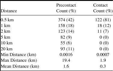
After creating the water variable layers, I used the “Select by Location” command to determine the number of sites within specified distances from hydrologic features by time period. I used distances of 0.5, 1, 2, 5, 10, and 20 km to denote the distance of sites from water features. I chose these distances based on ethnographic and historic accounts for average daily travel distances (Ewers Reference Ewers1958; Landals Reference Landals, Kelley and Kooyman2004; Wilson Reference Wilson1924). The results (Table 2) include counts and percentages to account for differences in accumulation time (approximately 1,000 years vs. 200 years) and to biases in archaeological survey and excavation that favor the discovery of Precontact site types (Landals Reference Landals, Kelley and Kooyman2004). The results show that, while there are more Precontact sites located within 0.5 km of a water source, the percentages of Precontact sites are more evenly distributed over a range of distances from 0.5 km (42%) to up to 20 km (11%). This is in stark contrast to the Contact-period sites, which are predominantly located within 0.5 km (81%) and 1 km away (12%), with no sites located over 2 km away.
Proximity to Water by Time Period.

Proximity to water was also assessed using the Generate Near Table tool, which provides an output table of the closest distances to a given feature for each point within a given data layer. From these tables, I calculated minimum, maximum, and mean distances of sites from a water source by time period (Table 2). While the minimum distance to water is not significantly different between the Precontact and Contact periods (0.0016 km vs. 0.0007 km), analysis shows that sites, on average, are located closer to water sources during the Contact period (0.3 km vs. 1.6 km), and Contact-period sites are never located as far away from water as Precontact-period sites (1.9 km vs. 19.4 km).
Wooded Areas
Analysis of distance from wooded areas used the same methods as the water variable (Table 3). While a greater percentage of Contact- as opposed to Precontact-period sites lie within 0.5 km of wooded area (44% vs. 17%), the correlation is not as strong as with water. Indeed, the second highest percentage of sites found in both the Precontact and Contact periods lie at distances ≥ 10 km (41% and 28%).
Proximity to Wooded Areas by Time Period.

The Near Table analysis for wooded areas shows that sites from both the Precontact and Contact periods are located within wooded areas (0 km) and at relatively far distances from wooded areas (89.9 km and 61.8 km). While the average proximity of Precontact sites to wooded areas is greater than that of Contact sites (14.34 km vs. 8.96 km), neither are on average clustered in particularly close proximity to wooded areas (Table 3).
Landscape Complexity
Finally, I assessed the relationship of sites to the complexity of the landscape by dividing the landscape complexity polygon layer into individual polygons by each of their complexity designations (1–3). The Spatial Join Tool then selected and counted the number of sites that fell into each polygon by time period. The results of this analysis appear in Table 4 and reveal that, while almost all the sites for both time periods lie within landscape complexity zones 1 (Best) and 2 (Good), most Precontact-period sites are found within zone 2 (79%), and a majority of Contact period sites are located within zone 1 (54%).
Count of Sites by Landscape Complexity Designation by Time Period.

Discussion
Water
Of the three landscape variables tested, proximity to water shows the most significant difference between the Precontact and Contact periods. The data show a clear preference for choosing camp locations near water sources during the Contact period. In fact, the maximum distance that any Contact-period site is located from a water source is less than 2 km, while Precontact-period sites were located at distances of up to nearly 20 km away from sources of water. These results confirm Landals's (Reference Landals, Kelley and Kooyman2004) hypothesis that Contact-period sites tend to be located closer to water than Precontact-period sites.
These patterns may also reflect changes in the seasonal round between the two periods. Unfortunately, not enough sites produced seasonality information to make the season of occupation a viable category within this analysis. However, based on those sites where the season of occupation is known coupled with ethnohistoric accounts, it is likely that the seasonal use of riparian areas may have experienced change between the two periods (Cooper Reference Cooper2008; Peck Reference Peck2004). Access to water and coulee systems was an important component of Late Precontact bison hunting (Brink Reference Brink2008; Kornfeld et al. Reference Kornfeld, Frison and Lou Larson2010). Winter camps, especially those associated with the jumping and processing of communal kills would favor riparian zones that provided not only the requisite topography for the hunt, but also the large amounts of water and wood necessary to process large kills (Vickers and Peck Reference Peck2004). Additionally, these areas provided shelter from harsh weather. In the summer, however, river valleys and foothills would be less intensively occupied in favor of open plains, since low-lying river valleys would be hot, infested with insects, and foul with the smell of decomposing kills (Schultz Reference Schultz1962). Because pedestrian hunters, dogs, and bison could all depend on surface water bodies such as kettle lakes and small seasonal springs, the pedestrian Blackfoot could afford to camp on the open plains and hunt using pounds or traps that required less topographic relief. With the advent of the horse, however, rivers and other permanent water sources became essential criteria of camp location at all times of the year.
Wooded Areas
The results of this analysis show that Contact-period sites are, on average, located closer to wooded areas, although this correlation is not as strong as proximity to water. Both the Contact and Precontact period exhibit similar distributions, with sites located very near to and far from wood resources. The clustering of sites within either close or far distances from wooded areas may be the result of the seasonal use of these areas and the resources they provide. Wooded areas were important for the pedestrian Blackfoot, especially during the cold months when they provided shelter, fuel, and raw materials for the construction of bison pounds (Vickers and Peck Reference Peck2004). During the Contact period, wood continued to be an important resource for these reasons as well as those directly related to horse management, such as bark being used as supplemental feed for horses. Furthermore, with the horse the Blackfoot could live further from wooded areas since a horse could carry fuelwood back to camp. Therefore, this pattern fits expectations for both periods.
Landscape Complexity
Almost all the sites included in this study fall within landscape complexity zones 1 or 2, an expectable result since most of the project area consists of these two zones. However, Precontact sites are more often located within those zones that are only considered good for horses while Contact-period sites exhibit a slight preference for those areas determined the best for horses. These results suggest that, while topographic complexity was most likely an important characteristic of Blackfoot horse husbandry, as Landals (Reference Landals, Kelley and Kooyman2004) and Ewers (Reference Ewers1955) suggest, finding the very best topographical conditions did not influence site selection as strongly as water since, in general, much of the landscape (particularly areas near river bottoms and coulees) provided adequate topographical relief for securing and separating individual horse herds. These results also suggest that those areas identified as good topographically for pasturing horses are also those that are good for driving or pounding bison.
Broad Territorial Movements
The level of clustering, as determined by the Average Nearest Neighbor and site density analysis, suggests that settlement choice focused on a set of environmental and cultural criteria found in specific locations across the landscape. The cluster analysis revealed several changes to territorial occupations between the Precontact and Contact periods, the most prominent pattern being a shift in occupation away from the northeasternmost corner of the project area (western Saskatchewan) into the northeastern portion of Montana (Figure 3a–b). This broad pattern of change may have occurred for several reasons. Because horses have specific care requirements that differ from those of humans, dogs, and even bison, regions that during the Precontact period were suitable for pedestrian hunters were less well-suited for keeping large horse herds, and therefore were abandoned. This appears most clearly in the Great Sand Hills region of Saskatchewan, which had a high density of Precontact sites, but was virtually abandoned during the Contact period (Figure 3). Even though large populations of bison inhabited this area up until the second half of the nineteenth century, this region lacks the water sources necessary to maintain large horse herds (Hanna Reference Hanna2007). As a result, in the Blackfoot worldview, the Great Sand Hills became “a lonely landscape in the eastern part of traditional Blackfoot country, where living people seldom ventured” (Hungry-Wolf Reference Hungry2006:62). The fact that this region was transformed from frequently utilized area to a place only the dead could inhabit further highlights the great importance that the Blackfoot people placed on their herds (Dempsey Reference Dempsey2003:84).
Other factors not related to horse husbandry may have also influenced broad territorial movements. First, in the mid-nineteenth century, Euroamerican encroachment and over-hunting caused large-scale bison migrations that could account for the shift in occupation toward the northeastern portion of Montana during the Contact period as groups followed dwindling bison herds (Roll and Fisher Reference Roll and Fisher2010; Schultz Reference Schultz1907:390). Second, site distributions were probably affected by fluctuating territorial, trade, and warfare relations with neighboring tribes, particularly the encroachment of the Gros Ventres, Assiniboine, and Cree into western Saskatchewan (Binnema Reference Binnema2001:13). Third, it is also possible that the location of trading posts, particularly those installed by the American Fur Company in Montana along the Missouri River in the nineteenth century, altered settlement patterns by attracting Blackfoot to them. However, these posts were not located arbitrarily across the landscape, but positioned to maximize trade with tribes (Moore Reference Moore2012). Therefore, Blackfoot settlement may have influenced the location of trading posts rather than the opposite. Finally, some patterns may result from sampling bias created by incomplete data or differential archaeological attention to particular regions. For example, historic accounts show that the Blackfoot would often camp in areas south of the North Saskatchewan River in Alberta; however, Contact-period archaeological sites are relatively absent from this region (Figure 3b).
Persistent Places
These data also highlight two major regions within the project area that exhibit evidence of persistent use through time, the foothills of Alberta and the area extending from roughly the present-day Blackfeet Indian Reservation to the Sweet Grass Hills in Montana and north into Alberta's Cypress Hills (Figure 3c). This is no surprise, as these areas provide ideal natural resource patches, climatic conditions, and proximity to ancient sacred sites and named places located along the Rocky Mountain foothills. Although a nomadic people, the Blackfoot still constructed permanent places on the landscape that were habitually revisited. These persistent places are often associated with specific points on the landscape linked by a network of paths and trails and encompass both natural resource patches (e.g., places to gather lodge poles, berry patches, paint, and stone sources) as well as areas of cultural significance, including prominent topography (e.g., Chief Mountain), natural features or anomalies on the landscape (e.g., the Sweet Grass Hills and Cypress Hills, or glacial erratics), hydrology (e.g., named lakes, rivers, and streams), monuments (e.g., medicine wheels, Napi effigies, and cairns), sacred sites that are perceived as focal points of spiritual energy (e.g., Writing-On-Stone), and the locations of both mythical and historical events. The Blackfoot visit these areas not only to obtain key resources, but also to fulfill ritual obligations, renew ties with ancestors, keep history and songs alive, and negotiate with spirits for the welfare of the group (Oetelaar Reference Oetelaar2014, Reference Oetelaar, Lovis and Whallon2016; Oetelaar and Oetelaar Reference Oetelaar and Oetelaar2006, Reference Oetelaar, Oetelaar and Cannon2011).
Horse husbandry may not have significantly altered established named or sacred places, but it did foster new ones. Several new sacred places associated with horses were revealed to the Blackfoot. These places are most often associated with water and are imbued with powerful horse medicine. Two examples found in Montana are Horse Lake, a site found east of St. Mary (John R. Murray, personal communication 2014), and Mitten Lake at the base of Mitten Mountain just northeast of Little Plume Mountain (Zedeño et al. Reference Zedeño, Jelinek and Toupal2006). Rock effigies in the name of famous horses were also constructed in the same fashion as other landscape-scale markers such as medicine wheels (Dempsey Reference Dempsey1994:65), as were new forms of biographic rock art (Laycette and Keyser Reference Lycett and Keyser2017; Peck and Hudecek-Cuffe Reference Peck, Hudecek-Cuffe, Brink and Dormaar2003:24). Finally, several places also gained cultural significance as areas where horses were known to flourish or take on special properties. For example, Kobell Coulee on the modern-day Blackfeet Indian Reservation is said to be an area that contains a special mineral or root that makes horses stronger, faster, and better looking. Today, horses flock there in the winter and come out in spring looking more vibrant. Knowledge of this place has been passed down from generation to generation, and it is likely that it was also used during the Historic period as an important wintering ground for horses (Tyson T. Runningwold, personal communication 2014).
In addition to producing new places associated directly with horses, the advent of the horse also brought new attachments to the land that evolved as established landscape features were given new meaning. For example, as the locations of jumps and pounds were increasingly abandoned, they started to take on a new role as persistent places imbued with power. Well-known bison kill sites such as Head-Smashed-In Buffalo Jump (Estipah-skikikini-kots) and Old Women's Jump were visited repeatedly by the equestrian Blackfoot despite discontinuation of their use for procuring bison (Brink Reference Brink2008; Duke Reference Duke1991; Paul Raczka, personal communication 2014; Truman Hall, personal communication 2014). The same may have been true for smaller winter hunting locales, particularly along the Two Medicine River in Montana and other places along the Rocky Mountain foothills.
Conclusion
This research provides an opportunity to revisit the history of the horse and its incorporation into the lives of nomadic hunters on the Northwestern Plains. In doing so, this work unites a set of GIS methodologies and data into a study of cultural change that both expands on previous work and adds a new, material dimension for understanding the dynamics of this equestrian transition. More broadly, this research contributes new methods and data for better understanding the relationship between hunting and pastoralism in ancient societies.
Some scholars describe the introduction of the horse into the Plains as the catalyst for a true “pastoral shift,” suggesting that the equestrian Blackfoot may be better understood as nomadic pastoralists who moved about the Plains based on their horses’ needs rather than the needs of pedestrian bison hunters (Ewers Reference Ewers1955; Hämäläinen Reference Hämäläinen2003, Reference Hämäläinen2008). This study supports this claim. Blackfoot horse culture represents a unique system that differs from classic pastoralist models in that while actual “diet” did not experience any change, hunting without horses came to represent a significant loss in power and subsequently the ability to obtain bison. As a result, all efforts were made to avoid the loss of horses. These husbandry concerns had numerous effects on Blackfoot lifeways, including not only their social, political, economic, and religious institutions, but also their understanding and use of the landscape.
Although equestrian bison hunters maintained elements from their former pedestrian lifeway, such as the continued use of significant resources and persistent places, the way in which they interacted with their landscape differed in several key ways as the result of horse husbandry. While the horse enabled a new independence from many of the large-scale landscape engineering efforts that tied the Blackfoot to specific places, at the same time it bound them even more directly to the land and its resources. Variables in settlement choice, therefore, shifted from a focus on attracting bison through the construction of complex, landscape-scale features, to those landscape variables crucial to maintaining large horse herds. This caused the abandonment of some areas in favor of those more suitable for horses (e.g., locations with ample water, forage, shelter, topographic containment to minimize straying and theft, and cottonwood and aspen bark for supplemental feeding; Figure 4). Movements between these places would have also been altered, as mounted Blackfoot bands would have had to move more frequently to avoid overgrazing. As a result, locales such as water bodies, seasonal pasture zones, settlements, and culturally significant places, all combined to shape a broad geography of interactions that frame and materialize the landscape of the equestrian Blackfoot people.
Example of an ideal location for an equestrian camp near the Two Medicine River, Montana.

Acknowledgments
I thank the Blackfeet Nation and Blackfoot consultants who participated in this project, in particular John and Carol Murray, Allan Pard, Paul Raczka, Tyson Runningwolf, and Mouse Hall. Their guidance and input was instrumental to this research. This work also benefited from comments and discussion from Marìa Nieves Zedeño, TJ Ferguson, Mary Stiner, Barney Pavao-Zuckerman, Allison Landals, Trevor Peck, Jack Brink, Cannon Daughtrey, and Joey Williams. Marìa Nieves Zedeño graciously translated the abstract into Spanish. I would also like to thank the Montana State Historic Preservation Office, the Archaeological Survey of Alberta, and the Heritage Conservation Branch of Saskatchewan for providing me with data for this project. This work was funded by a National Science Foundation Doctoral Dissertation Improvement Grant (#1521950).
Data Availability Statement
All spatial data used in this work were acquired from existing state and provincial repositories or are categorized as open source data. The final geospatial database produced as part of this research was sent to the appropriate officials at each state and provincial repository. This dataset may be made accessible to others at the discretion of these offices. All original recordings, field notes, and transcripts from ethnographic interviews conducted by the author as part of this research are stored at the University of Arizona. The author and relevant Blackfeet tribal officials are the only ones with access to this information.