1. Introduction
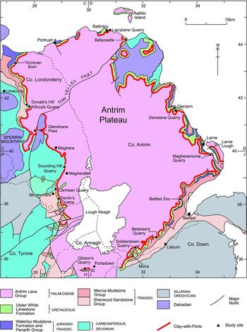
The Clay-with-Flints deposit (Mitchell et al. Reference Mitchell, Cooper, Hards and Meighan1999; Simms, Reference Simms2000; Mitchell, Reference Mitchell and Mitchell2004a, Reference Mitchell2010) is exposed in escarpments surrounding the Antrim Plateau in Northern Ireland (Fig. 1). It occurs mainly in counties Antrim and Londonderry and is sandwiched between chalk of the Upper Cretaceous Ulster White Limestone Formation (Fletcher, Reference Fletcher1977; Mitchell, Reference Mitchell and Mitchell2004b) and basalts of the Palaeogene Antrim Lava Group (Cooper, Reference Cooper and Mitchell2004). Despite bearing identical names, the Clay-with-Flints of Northern Ireland is quite dissimilar to the Clay-with-Flints Formation of southern England. The latter has demonstrably developed through cryogenic reworking of remnant Palaeogene clastics on the chalk plateaus during Pleistocene time (Hodgson, Catt & Weir, Reference Hodgson, Catt and Weir1967). In contrast, the Clay-with-Flints in Northern Ireland contains a significant volcanic component and its discontinuous distribution is a primary feature rather than a consequence of later dissection. The stratigraphic position of the Northern Ireland Clay-with-Flints across the Cretaceous–Palaeogene (or K–T) boundary, and the most recent explanation of its origin as a primarily volcanic deposit (Mitchell et al. Reference Mitchell, Cooper, Hards and Meighan1999; Simms Reference Simms2000; Mitchell, Reference Mitchell and Mitchell2004a, Reference Mitchell2010), imply a critical stratigraphic subdivision for the sequence of events regarding the onset and duration of volcanism in this part of the North Atlantic Igneous Province (see Ganerød et al. Reference Ganerød, Smethurst, Torsvik, Prestvik, Rousse, McKenna, Van Hinsbergen and Hendriks2010).
Simplified geological map of the Antrim Plateau showing stratigraphic position and key localities of Clay-with-Flints at base of Antrim Lava Group (modified from Mitchell Reference Mitchell and Mitchell2004a).

The predominantly volcanogenic nature of the clay component of the Clay-with-Flints was established through petrography and geochemistry (Mitchell et al. Reference Mitchell, Cooper, Hards and Meighan1999; Simms, Reference Simms2000), while the origin of the flints is uncontentious in that they have been derived from the underlying Cretaceous limestone via dissolution (McGugan, Reference McGugan1957; Simms, Reference Simms2000). However, Mitchell et al. (Reference Mitchell, Cooper, Hards and Meighan1999) assigned part of the Clay-with-Flints deposit to a distinct stratigraphic unit that they termed the ‘Donald's Hill Ignimbrite Formation’, exposed in quarries and natural outcrops along c. 30 km of the western side of the Antrim Plateau. Their model invoked a pyroclastic flow of ‘voluminous silicic volcanism in the Northern Ireland sector of the British Paleogene Igneous Province’. Because of its position directly on top of the Cretaceous chalk, it was argued that this pyroclastic flow took place before the outpouring of the Antrim Lava Group (Mitchell et al. Reference Mitchell, Cooper, Hards and Meighan1999).
This paper reassesses the field and petrographical relationships of the Clay-with-Flints deposit at key sites around the Antrim Plateau (Fig. 1), including those that were assigned to the Donald's Hill Ignimbrite Formation by Mitchell et al. (Reference Mitchell, Cooper, Hards and Meighan1999). Our findings do not support previous claims for a regionally extensive pyroclastic flow that preceded emplacement of the Antrim Lava Group, and accordingly the Donald's Hill Ignimbrite Formation is abandoned as a formal stratigraphic term.
2. Geological context
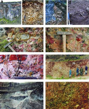
Exposures of Clay-with-Flints are found around the entire escarpment of the Antrim Plateau (Fig. 1) and, because of this, it can reasonably be assumed that the deposit extends beneath the basalt cover. The deposit is, on average, ≤ 1 m thick but is locally discontinuous. The Clay-with-Flints occurs between the eroded top of the Upper Cretaceous chalk of the Ulster White Limestone Formation, ranging in age from Santonian to Maastrichtian (Mitchell, Reference Mitchell and Mitchell2004b), and below the succeeding Paleocene basalts of the Antrim Lava Group (Cooper, Reference Cooper and Mitchell2004; GSNI, 1997). The regional dip of the Antrim Lava Group is shallow and reflects the generally flat attitude of the underlying chalk, upon which it rests unconformably. On a regional scale the upper surface of the chalk is flat to gently undulating, but at a local scale the surface can be deeply incised by karstic sinkholes and dolines up to 15 m deep with pinnacles between (Simms, Reference Simms2000) (Fig. 2a). In addition to hosting thicker Clay-with-Flints deposits (Fig. 2a, b), dolines often contain angular blocks of basalt (Fig. 2a) that commonly show evidence of autogenic brecciation and formation of palagonite (Simms, Reference Simms2000). Dolines can also accommodate the thickened bases of lava flows (Fig. 2c). Cave passages, often aligned along fractures, occur within the chalk and are usually choked with Clay-with-Flints deposits (Fig. 2D). The style of karstification of the chalk demonstrates that cementation and jointing pre-dated the deposition of the Antrim Lava Group (Simms, Reference Simms2000).
Field relationships and facies of the Clay-with-Flints. (a) Clay-with-Flints (CwF) overlain by blocky basalt (Bb) that fills dolines between karst pinnacles, Magheramorne Quarry (quarry face c. 20 m in height). (b) Facies 1 (F1) of the Clay-with-Flints showing the touching framework of largely complete flint nodules with grey to light-brown clay matrix containing pisoliths, overlain by Facies 2 (F2) composed of chocolate-brown to brick-red clay with reverse grading of fragmented and whole iron-stained flint nodules; Gibson's Quarry (hammer for scale). (c) Doline within chalk at Magheramorne Quarry containing whole and fragmented flints (CwF), blocky basalt (Bb) and the base of overriding lava flow (hammer for scale). (d) Close-up of laminated clay with occasional angular flints (arrowed) in cave within chalk at Magheramorne Quarry (hammer for scale). (e) Unsilicified base layer of Donald's Hill deposit showing fractures in flint at point-to-point contacts (arrowed) (hammer head 12 cm). (f) Silicified Facies 2 of the Donald's Hill deposit, apparent eutaxitic texture truncates against reddened angular and rounded flints (arrowed) (hammer head 12 cm). (g) Donald's Hill silicified Facies 2 composed of mostly broken, angular flints that show reddening by iron (arrowed) and post-silicification fractures that cut across the layer (hammer head 12 cm). (h) Irregular contact between Facies 1 and 2 (F1, F2), Demesne Quarry. (i) Clay-with-Flints (CwF) fill channel between lava flows, Soldierstown Quarry (quarry face c. 10 m). (j) Facies 2, pisolith (arrowed) rich clay, Gibson's Quarry (field of view 25 cm).

3. Field relationships and facies
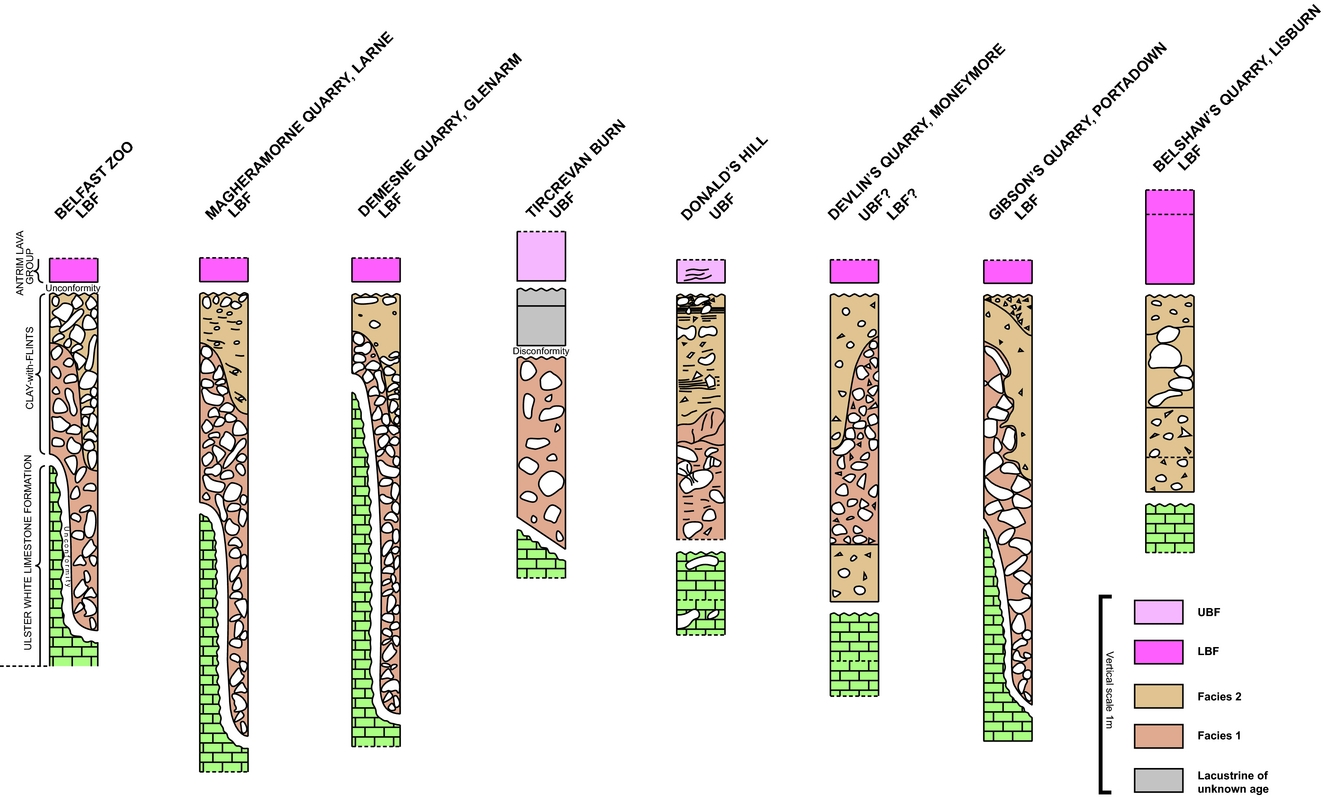
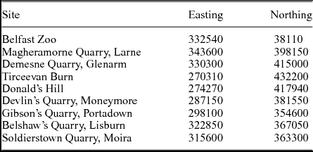
Facies analysis of eight sedimentary logs through Clay-with-Flints deposits (Fig. 3) show that at many of the key localities (Table 1) two main facies can be recognized. Facies 1 is a lower, flint-rich, clast-supported deposit with mainly whole flints and less-abundant fragmented clasts (Fig. 2b, lower part of image). The matrix is a soft to very firm clay, ranging in colour from grey to chocolate brown, and containing irregular ferruginous concretions. Flints range from grey to brown to reddish-purple in colour, but frequently display white weathered crusts. Many flints show extensive internal shattering, with fractures radiating from clast-to-clast contacts (Fig. 2e). Facies 2 is an upper, flint-poor to flint-rich, matrix to clast-supported deposit with both whole flints and fragments (Fig. 2b, upper part of image). Angular shards of flint are particularly abundant in Facies 2 and are randomly scattered (Fig. 2f, g). Matrix is a soft to very firm clay, mostly chocolate brown to brick red and contains numerous small, irregular ferruginous concretions (Fig. 2j). Large whole flints commonly occur at the top of these units. Flints locally display orange to vivid red discolouration related to iron oxide staining (Fig. 2g).
Sedimentary logs of key Clay-with-Flints exposures showing facies attributions. See Figure 1 for geological distribution of the individual logged sections.

Localities of key Clay-with-Flints sections represented in Figure 3.

The proportion of flint varies dramatically between the two facies such that the deposit may be clast- and/or matrix-supported. The boundary between Facies 1 and Facies 2 is commonly irregular (Fig. 2b, h).
3.a. Soldierstown quarry
Notably, the section at Soldierstown Quarry near Moira (Fig. 1) is untypical in that the deposits here are present at two stratigraphic levels. As usual there is a development of Clay-with-Flints below the lowest lava flow of the Lower Basalt Formation but, surprisingly, there is a second unit between the first and second lava flows (Fig. 2i). Unfortunately this disused quarry became flooded soon after it was first described in the late 1990s and it has not been accessible since for logging. However, field photographs and notes show that the upper Clay-with-Flints deposit occupies a channel-shaped depression in the top of the first lava flow that is, in turn, overstepped by the succeeding lava flow (Fig. 2i). Rare fragments of basalt are found within the channel but the dominant clast type is flint, implying that material was being sourced from a chalk surface beyond the limit of the lava field.
3.b. Donald's Hill and the western basalt plateau
The so-called Donald's Hill Ignimbrite Formation crops out along a c. 30 km stretch of the western side of the Antrim Plateau between the stratotype section at Donald's Hill and Sounding Hill Quarry (Fig. 1) (Mitchell et al. Reference Mitchell, Cooper, Hards and Meighan1999). At Donald's Hill itself the deposit appears continuous and is 0.9–1.1 m thick (Fig. 3), resting on the Ulster White Limestone Formation and overlain by basalt that is considered to belong to the Upper Basalt Formation (Lyle & Patton, Reference Lyle and Patton1989; GSNI, 1997). The deposit itself can be divided into a lower, less silicified layer and an upper, strongly silicified layer (Fig. 2e, f). The boundary between the layers is relatively sharp but undulatory in nature, causing the two layers to vary in thickness. Apparent eutaxitic textures (often referred to as ‘flow banding’) are clearly visible in the upper strongly silicified part of the deposit but do not wrap around the larger clasts (Fig. 2f), so must have developed before compaction. In the lower unsilicified part of the unit, evidence of compaction is recorded by fracturing of flints at point-to-point contacts (Fig. 2e). In the Kilhoyle quarry (Fig. 1), c. 1 km to the SW, the deposit remains on chalk and varies in thickness over the range 0.6–0.8 m. Further south on Glenshane Mountain its thickness is still c. 1 m, but here it overlies red-bed sandstones of Carboniferous and Triassic age (GSNI, 2007).
4. Petrology and petrography
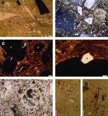
Petrographically, the Clay-with-Flints has a matrix dominated by clay minerals with minor quantities of fine-grained, angular to well-rounded quartz grains (Fig. 4a) and occasional sub-rounded basalt rock fragments and flints of varying size that can be angular to well rounded (Fig. 4b).
Thin-section photomicrographs of Clay-with-Flints constituent minerals and textures. (a) Typical Clay-with-Flints (Facies 2) containing shards of flint (f) in a clay matrix that contains fine-grained angular to well-rounded quartz grains (q) at Carmean Quarry (NI5683) (scale bar 20 µm). (b) Silicified Clay-with-Flints containing angular flints (f), detrital quartz grains (q), a sub-rounded basalt clast (b) and deformed fiamme-like structures (arrowed); Donald's Hill (field of view 6 mm). (c) Spherical to irregular, dark red ferruginous pisoliths (p) that have come together during growth (arrowed), Gibson's Quarry (NI5689) (scale bar 20 µm). (d) Detail of a detrital quartz grain (q) that has been partially enclosed by a pisolith, Gibson's Quarry (NI5689) (scale bar 50 µm). (e) Detail of silicified Clay-with-Flints containing undeformed foraminifera, Donald's Hill (NI5715) (scale bar 10 µm). (f) Chitinous shell Devlin's Quarry (NI 5682) (scale bar 200 µm). (g) Un-burnt plant debris, Devlin's Quarry (NI 5682) (scale bar 200 µm).

Small spherical masses, typically ≤0.5 cm in diameter, occur in varying proportions at nearly all the key exposures and in both facies described above (e.g. Fig. 2j). These concretions, interpreted by Mitchell et al. (Reference Mitchell, Cooper, Hards and Meighan1999) as accretionary lapilli, are rarely round, are always ferruginous and are particularly abundant in the chocolate-brown-coloured clays associated with Facies 2. In thin-section it can be seen that they include detrital quartz grains of similar nature to those in the surrounding clay matrix (Fig. 4c). In some cases these concretions partially envelop detrital quartz grains (Fig. 4d), which indicates that they have grown in situ.
The presence of angular to well-rounded, strained (or metamorphic) quartz grains and sub-rounded basalt rock fragments supports their origin as detrital. Further detrital constituents are biogenic and include abundant foraminifera (Fig. 4e), sponge spicules and occasional chitinous and carbonaceous fragments (Fig. 4f, g). The foraminifera (Fig. 4e) and sponge spicules are derived from the underlying Cretaceous chalk (McGugan, Reference McGugan1957), while the chitinous and carbonaceous material was incorporated at the time of Clay-with-Flints accumulation and is likely to be of Paleocene age. Many of these delicate fossil remains are intact and do not show signs of having been involved in a hot, high-energy pyroclastic flow. Features formerly identified as fiamme are visible in thin-section and appear to wrap around clasts (Fig. 4b).
5. Discussion
5.a. Donald's Hill Ignimbrite Formation
The volcanogenic origin (Mitchell et al. Reference Mitchell, Cooper, Hards and Meighan1999; Simms, Reference Simms2000) for much of the clay component of the Clay-with-Flints is not disputed. Geochemical comparisons made by these authors with the basaltic lithologies of the Antrim Lava Group are unequivocal. However, we find no evidence to support the earlier conclusion that a period of explosive volcanism deposited this unit, as a widespread ignimbrite (the Donald's Hill Ignimbrite Formation; Mitchell et al. Reference Mitchell, Cooper, Hards and Meighan1999), prior to the onset of basaltic volcanism in this region. Within the small spheroidal concretions, interpreted by Mitchell et al. (Reference Mitchell, Cooper, Hards and Meighan1999) as accretionary lapilli, are detrital quartz grains similar in composition and grain size to those contained within the surrounding clay matrix (Fig. 4c); however, the manner in which the concretions partially envelop detrital clasts (Fig. 4d) indicates that they have grown in situ after deposition of the clay. Furthermore, these spheroidal structures are found not only at the Donald's Hill locality, but also in typical Clay-with-Flints for which a pyroclastic origin has never been proposed. Rather than being accretionary lapilli, these concretions are more likely to be ferruginous soil pisoliths similar to those described from tropical weathering horizons at Tamil Nadu, Chennai, southeastern India (Achyuthan & Ferdorf, Reference Achyuthan, Ferdorf, Kapur, Mermut and Stoops2008). Importantly, formation of these concretions in palaeosols is consistent with the palaeoclimatic conditions that prevailed in Northern Ireland during Palaeogene time.
The apparent eutaxitic texture, or ‘flow banding’, is more obvious in the upper strongly silicified part of the Donald's Hill Ignimbrite Formation than in its lower part (Fig. 2e–g), which is contrary to what would be anticipated for an ignimbrite deposit (e.g. Branney & Kokelaar, Reference Branney and Kokelaar1992; Kobberger & Schmincke, Reference Kobberger and Schmincke1999). Furthermore, the eutaxitic texture observed in the Donald's Hill Ignimbrite Formation does not wrap around the larger clasts (Fig. 2f) and, as such, it must have formed before compaction. Together with the silicified nature of the deposit, the Donald's Hill Ignimbrite Formation was interpreted to have resulted from high-temperature welding of a pyroclastic flow. However, the post-depositional, compaction-related, point-to-point fracturing (Fig. 2E) and in situ shattering of flint nodules observed within the deposit could not have formed if welding had occurred during deposition. Moreover, the presence of delicate foraminifera, chitinous and carbonaceous fossils within the deposit (Fig. 4e–g) is inconsistent with transport and deposition by a high-energy pyroclastic flow. Lastly, the supposed fiamme observed in thin-section (Fig. 4b) are more likely to be features related to the shrink and swell or thermal contraction–expansion behaviour of soils, or can form from burial in lake sediments (e.g. Branney & Sparks, Reference Branney and Sparks1990). Hence the presence of apparent ‘fiamme’ may not be a decisive criterion in favour of a pyroclastic origin.
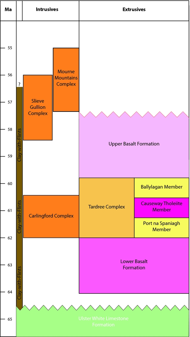
Radiometric dates from the Antrim Lava Group indicate that it was erupted during 64–57 Ma, with a quiescent episode of reduced magma production during c. 62–60 Ma (Fig. 5). In this ‘interbasaltic episode’ (e.g. Hill, Worden & Meighan, Reference Hill, Worden and Meighan2000, Reference Hill, Worden and Meighan2001; Ganerød et al. Reference Ganerød, Smethurst, Torsvik, Prestvik, Rousse, McKenna, Van Hinsbergen and Hendriks2010), the Causeway Tholeiite Member and the Tardree Rhyolite Complex were emplaced and likely also the Slieve Gullion and Carlingford igneous complexes further south (Cooper Reference Cooper and Mitchell2004; Cooper & Johnston Reference Cooper, Johnston and Mitchell2004; Ganerød et al. Reference Ganerød, Chew, Smethurst, Troll, Corfu, Meade and Prestvik2011, Reference Ganerød, Meade, Troll, Emeleus and Chew2013). However, the supposed presence of an ignimbrite (Donald's Hill Ignimbrite Formation) at the base of the lava pile has presented difficulties for interpreting the stratigraphy of the Antrim Lava Group. Firstly, there is a lack of pre-basalt source volcanoes with felsic activity in the region, and secondly the supposed Donald's Hill event layer occurs both in locations where the overlying Antrim Lava Group is interpreted to be Lower Basalt Formation (Fig. 3; e.g. south of the Tow Valley Fault) and in other locations where it is considered to be Upper Basalt Formation (e.g. north of the Tow Valley Fault; Lyle & Patton, Reference Lyle and Patton1989; GSNI, 1997). Our combined evidence therefore suggests that this supposed ignimbrite is actually a silicified variant of the typical Clay-with-Flints, a deposit that is demonstrably diachronous in its formation and is found beneath temporally distinct subunits of the Antrim Lava Group.
Revised stratigraphical column for Northern Ireland indicating diachronous formation of the Clay-with-Flints.

5.b. Clay-with-Flints
Although we have been able to demonstrate that pyroclastic flows were not responsible for the Clay-with-Flints between the top of the Ulster White Limestone Formation and the base of the Antrim Lava Group, the mode of accumulation, transport and deposition of these deposits is not altogether straightforward.
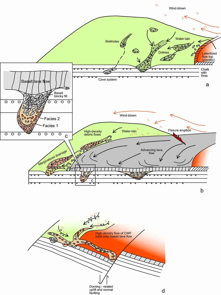
The two main facies recognized in most Clay-with-Flints sections (Fig. 3) indicate that more than one depositional mechanism has been involved in generating the deposit. Facies 1 is interpreted as forming by almost in situ accumulation of insoluble flint nodules during karstic weathering of the limestone landscape. This was followed by accumulation of a clay matrix derived from basalt. Given the abundant and variable distribution of pisoliths within the clay matrix to this facies, it is proposed that the clay was mainly redistributed by water into an initially open but clast-supported framework, or regolith, of flint nodules by illuviation (Fig. 6a, b). That water was an important agent for transporting this fine fraction is demonstrated by the presence of laminated red and brown clays within Palaeogene caves in the limestone, such as at Ballintoy and the Magheramorne and Larrybane quarries (Simms, Reference Simms2000) (Figs 1, 2d). Basaltic, and locally rhyolitic, ash from fissure and central volcano eruptions are also likely to have contributed to the fine component of the Clay-with-Flints, with wind dispersal carrying this material onto the chalk landscape far beyond the initial limits of the Antrim lava field (Simms, Reference Simms2000; Gould, Reference Gould2004) (Fig. 6a).
Model to account for the diachronous, multistage formation of the Clay-with-Flints. (a) Chalk landscape with ongoing karstification, pockets of flint regolith and an advancing lava field. (b) Water and wind transport of clay from lateritic soils from older lava flow tops, and wind transport of volcanic ash from fissure eruptions. Marginalization and alteration/blocking of karstic subsurface and surface drainage systems due to continued growth of lava field. (c) Close-up of doline with Clay-with-Flints and blocky basalt fill. (d) Potential role of block faulting and associated uplift and extension in remobilizing Clay-with-Flints back onto the lava field.

The shattered nature of the flints in the clast-supported regolith of Facies 1 was attributed by Mitchell (Reference Mitchell and Mitchell2004a) to either the result of repeated impacts during entrainment in a mass flow or to compactive pressures. However, the radiating pattern of fractures at clast-to-clast contacts (Fig. 2e) demonstrates that the fracturing in Facies 1 is related to compaction of the ductile matrix of the deposit, probably as a consequence of burial by the overlying lava flows. Further, the fracturing that cuts the silicified, upper layer of Facies 2 at Donald's Hill (Fig. 2f) indicates that it was silicified and brittle when compaction continued in the underlying unsilicified layer. Based on the above it would appear that silicification of the Clay-with-Flints occurred pre-burial by the advancing lava field. A speculative explanation for silicification could be that increased, localized heat flow resulted in hydrothermal circulation of groundwater through the underlying highly porous and permeable Triassic Sherwood Sandstone Group reservoir (GSNI, 2007), which caused silica dissolution in these rocks and subsequent precipitation in the overlying Clay-with-Flints.
As to why the Clay-with-Flints was remobilized is less clear cut, but several processes can plausibly be envisaged. Facies 2 contains unit-scale structures indicative of mobilization and flow, including dramatic reverse grading of flint nodules towards the top of beds (Figs 2b, 3). This reverse grading and breakage of flint nodules indicates that the deposit moved as a high-density mudflow. Angular shards of flint are particularly abundant in Facies 2 (e.g. Fig. 2g) and can be attributed to impacts between clasts during the transport and deposition of this facies as high-density mudflows. The occurrence of thickened deposits within karstic hollows and the uneven contacts observed between Facies 1 and 2 may indicate that karstification, through dissolution of the limestone and formation of caves, continued in areas not yet covered by lava flows. Indeed, karstification may actually have been enhanced by marginalization of subsurface karstic and surface drainage as the lava field progressed over the landscape (Figs 5c, 6b). The ongoing development of the landscape through a combination of karstic subsidence and surface lowering, the expanding lava fields and impacts on associated catchments may have contributed significantly to the remobilization of patches of Facies 1 of the Clay-with-Flints to give rise to the formation of Facies 2. A further mechanism for reworking and transporting the Clay-with-Flints may have been lava bulldozing or ‘ploughing’. Such ploughing is seen where a lava flow moves over the top of an older weathered lava flow (Wilson, Reference Wilson1965; Simms, Reference Simms2000; Schminke, Reference Schmincke2004) and might therefore account for at least some of the observed remobilization.
Remarkably, the occurrence of a substantial body of Clay-with-Flints in the Soldierstown Quarry within, and beneath, the Lower Basalt Formation (Fig. 2i) is anomalous, but is best explained by a model where locally the deposit was remobilized during the early stage of flood basalt outpouring. Its occurrence is difficult to account for by simple lava ploughing or debris-flow processes alone, and may reflect fault-related tilting in the area. The original source of the anomalous Clay-with-Flints deposit at Soldierstown is likely to have been some distance from any lava flows, judging by the scarcity of basalt clasts within it. To source this second layer from an area with no basalt cover back onto an area with basalt would require the formation of a depression or basin in the basalts into which it moved from higher ground, for which there is no obvious evidence. Alternatively, there may have been a temporary tilting of a fault block that altered the drainage pattern (Fig. 6d) and remobilized some of the Clay-with-Flints material onto the downthrown basalt surface. Indeed, evidence for regional-scale doming and tilting, most likely related to plume impingement on the crust, is seen in many places in Northern Ireland; an example exists in Carmean Quarry near Moneymore (Fig. 1), where dykes of the Donegal Kingscourt dyke swarm cut through the Ulster White Limestone Formation but were erosionally truncated prior to extrusion of the first flows of the Antrim Lava Group (Simms, Reference Simms2000; Cooper et al. Reference Cooper, Anderson, Walsh, Van Dam, Young, Earls and Walker2012).
6. Conclusions
Examination and reassessment of key Clay-with-Flints exposures from around the Antrim Plateau show it to be predominantly composed of two depositional facies. Both facies can be accounted for by sedimentary processes involving volcanic detritus and there is no need to invoke any contribution from a pyroclastic flow. Various features of the so-called ‘Donald's Hill Ignimbrite Formation’ were originally interpreted as primary features of ignimbrites, while our re-examination of the evidence shows that these are largely of secondary origin and most likely developed through pedogenesis and other non-volcanic processes. As such, we discount the ignimbritic origin and therefore the Donald's Hill Ignimbrite Formation.
The following features of the Clay-with-Flints deposit negate an ignimbritic mode of deposition.
• The supposed accretionary lapilli enclose detrital grains and must therefore have grown in situ after the clay was deposited. Furthermore, these spheroidal structures are found in almost all exposures of the Clay-with-Flints, and not just those previously proposed as pyroclastic in origin. They are more plausibly interpreted as pedogenic ferruginous pisoliths.
• At Donald's Hill, apparent eutaxitic textures are more obvious in the upper silicified part of the deposit than the lower unsilicified part, which is the opposite to what would be expected for an ignimbritic mode of deposition
• Compaction is seen to have affected the lower part of this same section where fractures at contacts between clasts are observed. Additionally, the eutaxitic textures do not wrap around clasts and, as such, appear to have developed before compaction.
• The presence of fragile biogenic material, including foraminifera, chitinous and carbonaceous fragments that would not have survived the high temperatures and energy associated with a pyroclastic flow, negate an ignimbritic deposition mode.
Our overall conclusion regarding the Donald's Hill Ignimbrite Formation is that it is not an ignimbrite but is merely a silicified version of typical Clay-with-Flints. Our reinterpretation resolves the difficulties that were raised by the seemingly anomalous presence of an ignimbrite beneath the Antrim Lava Group lava pile in this area of the North Atlantic Igneous Province.
The Clay-with-Flints in Northern Ireland comprises two components: flints derived by dissolution of the limestone; and clay originating from water-lain and wind-blown soil and volcanic ash. Transport by sedimentary processes is supported by the following: the occurrence of Clay-with-Flints deposit on top of bedrock other than the chalk indicates that there has been transport of at least some of the deposit; the identification of two main facies that show consistent stratigraphical arrangement (Facies 1 is a primary deposit developed largely in situ on the karst landscape and characterized by abundant, clast-supported, whole flints in a clay-rich matrix, while Facies 2, which overlies Facies 1 at most sites around the Antrim Plateau, displays features of a secondary remobilized deposit); reverse grading of Facies 2 deposits, and occurrence of angular flint shards indicating transport and deposition by high-density debris flows; the presence of abundant ferruginous pisoliths within both facies indicate derivation from soils; and partly broken, but otherwise unaltered, preservation of delicate biogenic material in both facies.
Setting geochronological constraints aside, it is clear that the Clay-with-Flints in Northern Ireland formed throughout a significant period of igneous activity and is therefore diachronous. This resolves stratigraphic issues that arose from the interpretation of it being formed during a single brief event (the former Donald's Hill Ignimbrite Formation). The diachroneity of the Clay-with-Flints in Northern Ireland raises the possibility of dating youngest detrital zircons which may be present in these deposits, and which could allow an inferred maximum age for the overriding basalt sequence.
Acknowledgements
The authors would like thank Rebecca Gould and Frances Deegan for useful discussions. This work would not have been possible without the pioneering effort of Dr Ian Mitchell who logged and sampled many of the Clay-with-Flints exposures that are reassessed here. Alex Donald and Hugh Crilly are thanked for diagram preparation and Sophie Omidian and Tobias Mattsson for help during the preparation of the manuscript. Reviews by Mike Simms (Ulster Museum), Fiona Meade and Rob Raine (BGS) have much improved this publication for which the authors are greatly indebted. MRC and KL acknowledge financial support from the Department for the Economy (DfE) and Northern Ireland Environment Agency (NIEA), and publish with the permission of the Executive Director of the British Geological Survey (NERC). VRT acknowledges Science Foundation Ireland (SFI) and the Swedish Science Foundation (VR) for their generous financial support.