Introduction
Deforestation and habitat degradation as a consequence of infrastructure development, including roads, mines, commercial agriculture, and hydroelectric dams, are particularly rampant in South-east Asia, where roughly 50% of the natural habitat, in particular lowland rainforests (<200 m elevation), has been destroyed over the past 20 years (Shwe et al. Reference Shwe, Sukumal, Oo, Dowell, Browne and Savini2020, Namkhan et al. Reference Namkhan, Gale, Savini and Tantipisanuh2021), much higher than figures generally observed in other tropical regions (Achard et al. Reference Achard, Eva, Stibig, Mayaux, Gallego, Rechards and Malingreau2002, Sodhi et al. Reference Sodhi, Posa, Lee, Bickford, Koh and Brook2010). Human population growth (Laurance et al. Reference Laurance, Peletier-Jellema, Geenen, Korster, Verweij, Dijck, Lovejoy, Schleicher and Kuijk2015) has also contributed to this rapid decline in habitat quality and loss of biodiversity in the region (Seiler Reference Seiler, Trocmé, Cahill, De Vries, Farrall, Folkeson, Fry, Hicks and Peymen2002, Benítez-López et al. Reference Benítez-López, Alkemade and Verweij2010). Particularly critical is the situation of the lowland forest in the biodiversity-rich transition zone of the Isthmus of Kra, between the Indo-Burma and Sundaic regions in southern Thailand (Hughes et al. Reference Hughes, Round and Woodruff2003), where more than 95% of the natural forest has been destroyed with the resident specialist birds increasingly under threat (Round Reference Round1988). Hydroelectric dams are rapidly emerging as the main threat to tropical forest biota among a myriad of anthropogenic factors (Benchimol and Peres Reference Benchimol and Peres2015). Besides displacing indigenous communities, dams disrupt the natural flow of rivers, critically affect fish populations, release vast amounts of greenhouse gases, and promote deforestation and fragmentation of pristine forests (Benchimol and Peres Reference Benchimol and Peres2015). Forest edge degradation within 100 m from the Chiew Larn shoreline was observed in a previous study (Irving et al. Reference Irving, Round, Savini, Lynam and Gale2018). Nonetheless, several large hydroelectric dams are still planned for construction in the region, e.g. the Lower Mekong region (Grumbine and Xu Reference Grumbine and Xu2011).
The ‘Near Threatened’ Great Argus Argusianus argus (BirdLife International 2016), is the largest ground bird inhabiting the Sundaic evergreen forest, from lowland to montane forest up to 1,200 m (Dinata et al. Reference Dinata, Nugroho, Haidir and Linkie2008). Threatened throughout its Sundaic range by habitat loss and hunting (BirdLife International 2016), the species prefers primary forest away from forest edges (Winarni et al. Reference Winarni, O’Brien, Carroll and Kinnaird2009) and has declined in abundance by 35% over the past 10 years (2001 to 2014) in southern Thailand, in part attributable to edge effects (Dawrueng et al. Reference Dawrueng, Ngoprasert, Gale, Browne and Savini2017). The edge effect recorded near the Chiew Larn reservoir highlights the species sensitivity to hydropower dams, making it a suitable indicator of forest degradation and biodiversity loss.
Native small mammal communities on newly created islands within the reservoir disappeared rapidly following inundation and fragmentation, and exotic species such as Rattus tiomanicus have taken over (Gibson et al. Reference Gibson, Lynam, Bradshaw, Fangliang, Bickford, Woodruff, Bumrungsri and Laurance2013). Avian communities on the islands and the mainland are dominated by a group of disturbance-tolerant species (Irving et al. Reference Irving, Round, Savini, Lynam and Gale2018). However, the effect of reservoir-related habitat degradation on large animals such as ground-dwelling Galliformes is poorly understood.
This project therefore aimed to investigate the effect of a hydroelectric dam on the Great Argus population in the remaining lowland forest surrounding the 30-year-old artificial reservoir at Khlong Saeng Wildlife Sanctuary (KSWS) in the northernmost part of the species range in the Isthmus of Kra (BirdLife International 2016). The landscape of KSWS varies from small to mid-size islands and mainland. The shoreline of the Chiew Larn reservoir is covered in compacted soil with patchily distributed grass cover and an almost complete lack of upper canopy cover. The area between 200 and 300 m from the shoreline is dominated by bamboo and other successional growth and still has excessive sunlight penetration. Over 300 m from the shoreline, the forest appears less disturbed, with moist understory, medium-sized trees, less successional growth, and lower sunlight penetration (Irving et al. Reference Irving, Round, Savini, Lynam and Gale2018).
We investigated the effect of the distance to the reservoir on the Great Argus density while controlling for topographical factors such as the degree of slope and elevation, which have been reported to affect the species’ distribution (Nijman Reference Nijman1998, O’Brien and Kinnard Reference O’Brien and Kinnaird2008, Winarni et al. Reference Winarni, O’Brien, Carroll and Kinnaird2009, Dawrueng et al. Reference Dawrueng, Ngoprasert, Gale, Browne and Savini2017). Lower species density was predicted in proximity to the reservoir edges due to habitat degradation.
Methods
Study site
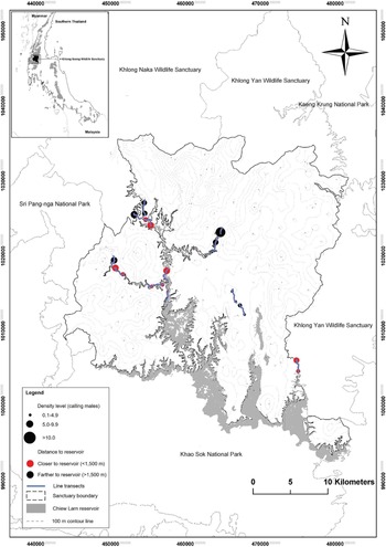
The study was conducted in Khlong Saeng Wildlife Sanctuary (KSWS), southern Thailand (9°01'–9°22'N and 98°30'–98°50' E; Figure 1), which covers an area of 1,155 km2 at an elevation ranging between 100 and 1,272 m above sea level (asl). The KSWS is one of 10 protected areas within the Khlong Saeng-Khao Sok forest complex (KSFC). The complex represents the largest natural habitat patch around the biodiversity-rich Isthmus of Kra area and can be considered the northernmost distribution of Sundaic species in southern Thailand.
Map showing the density of the Great Argus predicted from the best model with the lowest AIC at the 23 segments located in Khlong Saeng Wildlife Sanctuary.

The sanctuary’s main forest type is the evergreen forest with 165 km2 of lowland forest (below 100 m) flooded by the Chiew Larn reservoir, which was completed in 1986 (Nakhasathien Reference Nakasathien1989). The Chiew Larn reservoir is surrounded by two protected areas, the Khlong Saeng Wildlife Sanctuary in the north and Khao Sok National Park in the south, forming part of the largest (> 3,500 km2) contiguous forest area in the Sundaic region of southern Thailand (Gibson et al. Reference Gibson, Lynam, Bradshaw, Fangliang, Bickford, Woodruff, Bumrungsri and Laurance2013). The average annual temperature is 26.9°C. the wet season occurs from April to November, and the dry season occurs from December to March with an average annual precipitation of 2,632 mm (DNP 2006).
Field survey
The survey was conducted for three months (February–April 2017). We laid 13 line transects, six at the reservoir’s edge and seven in the forest interior, ranging in length from 1 to 2 km. Because of the mountainous topography, transects were set along patrol routes in areas where Great Argus was reported. Transects were set perpendicularly to the reservoir shore in order to avoid a “double effect” from water. Each line transect was surveyed three days consecutively in the morning (06h30–08h30) and late afternoon/evening (16h00–1800). For each bird detection, observers recorded the (1) time (hour), (2) focal species, (3) number of individuals, (4) detection cue/activity (visual or vocal), (5) location of the observer on the transect, (6) estimated distance between the observer and the focal species, and (7) angle between the observer and the bird relative to the transect. The observers were trained to estimate the calling distance before running the surveys by putting the calling animals in defined intervals (0–100 m, 101–200 m, 201–300 m, 301–400 m, 401–500 m, 501–1000 m, and over 1,000 m) (Gale et al. Reference Gale, Round, Pierce, Nimnuan, Pattanavibool and Brockelman2009). To reduce inaccurate distance estimation or detection, we did not collect data during high winds and heavy rain (O’Connor and Hicks Reference O’Connor and Hicks1980). To compare our results with a previous study in the region (Dawrueng et al. Reference Dawrueng, Ngoprasert, Gale, Browne and Savini2017), all 13 transects were transformed into 23 segments, and the data then were used to estimate the abundance of Great Argus. The segments were 500 m long and 1,000 m apart to avoid double-counting of the same individuals (see method used in Dawrueng et al. Reference Dawrueng, Ngoprasert, Gale, Browne and Savini2017).
Landscape variables
The landscape covariates used to model Great Argus abundance were: 1) the distance to the reservoir, 2) elevation, and 3) degree of slope. For each segment, the elevation was defined at the mid-point using a global positioning system (GPS). The overall elevation of the transects ranged between 92 and 341 m asl. The degree of slope was extracted using ArcGIS 10.3.1. at 500 m radius buffer along each segment. The distance to the reservoir was obtained using the “Near” function, from the middle of the segment to the nearest Chiew Larn reservoir shore.
The time (morning and late evening) and date of survey were included as sampling covariates. The landscape variables: degree of slope, elevation and distance to the reservoir shore were standardized by dividing the values by twice their standard deviation (Gelman Reference Gelman2008) in order to transform data into the same scale. The variables were tested for correlation using the non-parametric Spearman correlation rank-test (Spearman rho, ρ), and correlated variables (ρ > 0.6) were not included in the same model.
To ensure the latent abundance was larger than the observation counts, we tested three different values of K (100, 200 and 300), and found the K-value of 100 to be the least biased. We followed the procedure of Htike et al. (Reference Htike, Round, Savini, Tantipisanuh, Ngoprasert and Gale2020) to assess the model selection. The global model was then tested for goodness of fit by applying means of the Pearson chi-square test with parametric bootstrap resampling (1,000 resamplings). The global model performed well in fitting the data (bootstrapped P value = 0.458).
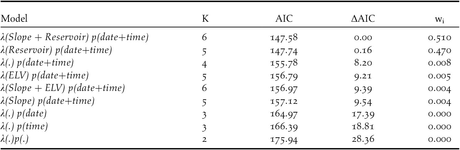
Variables that affected the detection probability and abundance were assesed using two steps of modelling. First, we tested if our two sampling covariates (time of the day and date of the survey) affected the detection probability or not. Both had an effect on the detection probability and were subsequently included in the abundance models following the procedure by Htike et al. (Reference Htike, Round, Savini, Tantipisanuh, Ngoprasert and Gale2020). Second, we tested three single variable models (degree of slope, elevation and distance to the reservoir shore) and two double-variable models (slope + elevation, slope + distance to reservoir) for any effects on Great Argus abundance (λ) and its probability of detection (p) (Table 1).
Model selection for the Great Argus Argusianus argus abundance in relation to landscape variables. Variables considered in the models included degree of slope (Slope), distance from the mid-point of the transect to the nearest reservoir shore (Reservoir), and elevation above sea level of the segment (ELV), with date (date) and time of the day (time) as sampling covariates. “K” represents the number of parameters, “AIC” for Akaike Information Criterion, “ΔAIC” for difference in AIC and “wi” for AIC weight. “λ” represent the function of abundance estimate, “p” for the function of detection probability and “λ(.) p(.)” is the null model without any covariates.

Data analysis
For the analysis, we followed the procedure by Dawrueng et al. (Reference Dawrueng, Ngoprasert, Gale, Browne and Savini2017), selecting only calling Great Argus males, the loud resonant kwow wow call made exclusively by males (Lekagul and Round Reference Lekagul and Round1991, Jayasilan and Davison Reference Jayasilan and Davison2006). Despite the species having a more extensive range of calls, the kwow-wow is the best-known call easy to detect.
The Great Argus abundance was defined using N-mixture models, which require count data and environmental variables to obtain the abundance over the whole area as well as for each segment (Royle Reference Royle2004). Data analysis was performed using program R version 3.4.3 (R Core Team 2018) with package ‘unmarked’ (Fiske and Chandler Reference Fiske and Chandler2011).
The total abundance (N) for the entire study site (23 segments) was converted to density by dividing by the effective survey area (Chandler et al. Reference Chandler, Royle and King2011, Amundson et al. Reference Amundson, Royle and Handel2014, Suwanrat et al. Reference Suwanrat, Ngoprasert, Sutherland, Suwanwaree and Savini2015, Dawrueng et al. Reference Dawrueng, Ngoprasert, Gale, Browne and Savini2017), calculated based on a fixed radius of 500 m from each segment multiplied by the total number of segments, having a total area of 18.06 km2.
Results
Estimation of Great Argus abundance and density
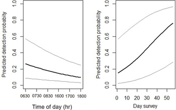
Great Argus was detected in 16 segments (69.6% of the total segments) but not in seven segments (30.4%). Time and date of survey likely affected the detection probability as indicated by the AICw i of 96% and ΔAIC >9. The detection probability was higher in the morning (06h30–08h30) than during the late afternoon (16h00–18h00) (βaverage=-1.2, 85% CI: -1.8–-0.5; Figure 2). In addition, the detection probability was low at the beginning of the survey but high during the later stages (βaverage=1.1, 85% CI: 0.6–1.6; Figure 2). Therefore, we used both (time of the day and date of survey) as covariates to analyse the abundance models (Table 1).
Relationships between expected detection probability and time of day (left) and between expected detection probability and the date of survey (right). Solid line represents predicted detection probability as a function of time of day (1 = 06h30–08h30, 2 = 16h00–18h00) and day of survey (1–56). Dashed lines represent lower and upper 85% confidence intervals.

The predicted mean of abundance per segment was 4.6 individuals (95% CI: 1.8-11.8), with a detection probability of 0.5 (95% CI: 0.1–0.8). The total population of the argus in KSWS within the sampled area of 18.06 km2 was estimated to be 108.7 individuals (95% CI: 41.7–272.8), equivalent to 5.9 calling males/km2 (95% CI: 1.2–9.6). Closer to the reservoir (between 0 and 1,500m), the estimated density averaged 3.0 calling males/km2, while the estimated density in the forest interior (> 1,500 m) increased to an average of 5.9 calling males/km2 (Figure 1).
Effect of the landscape on density
We found a strong correlation between elevation and distance to the reservoir (ρ =0.72, P = 0.0001), but no correlation between elevation and the degree of slope (ρ =.54, P = 0.0072), and between distance to the reservoir and the degree of slope (ρ =0.33, P = 0.13).
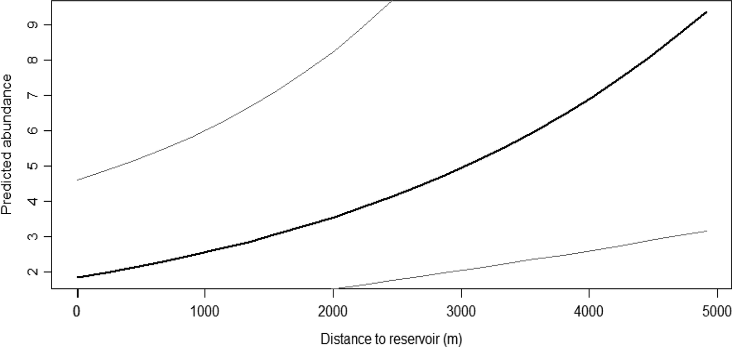
Among nine models, the model that included distance to reservoir shore and degree of slope, and another with only distance to reservoir shore were found to be the most supported, with ΔAIC > 8. These top two models were averaged to estimate the coefficients of the test variables. The farther the distance to reservoir’s edge, the higher the abundance of Great Argus (βaverage=1.13, 85% CI: 0.66–1.60; Figure 3).
The relationship between the predicted mean abundance of male Great Argus Argusianus argus and the distance from the reservoir. Solid line represents predicted mean abundance estimates and dash lines represent lower and upper 85% confidence intervals.

Discussion
With an estimated mean abundance per segment of 4.6 individuals, equivalent to 5.9 calling males(individuals)/km2, using N-Mixture models, the Great Argus density in the KSWS is relatively high when compared with other studies available for the species, 3.05 (95% CI: 1.9–4.8) males/km2 in Hala-Bala forest complex in the southernmost part of Thailand (Dawrueng et al. Reference Dawrueng, Ngoprasert, Gale, Browne and Savini2017), 3.7 males/km2 in Bukit Barisan Selatan National Park, Sumatra, estimated using distance sampling from line transects (Winarni et al. Reference Winarni, O’Brien, Carroll and Kinnaird2009), and around 2.0 males/km2 in primary forest, old and young secondary forest and 0.2 males/km2 in riverine forest at Kayan Mentarang National Park, East Kalimantan, Indonesia (Nijman Reference Nijman1998). In Hala-Bala WS, the Great Argus is reported to have declined over 13 years following an increase in edge degradation at the sanctuary boundary due to orchard expansion. The small size of the sanctuary, only 112 km2, makes it particularly vulnerable (Dawrueng et al. Reference Dawrueng, Ngoprasert, Gale, Browne and Savini2017). Similarly, edge effects also had an impact on the Great Argus density in Bukit Barisan Selatan National Park, where the species mostly occupied core areas of the primary and tall secondary forests with low human disturbance (Winarni et al. Reference Winarni, O’Brien, Carroll and Kinnaird2009).
The covariates (time of day and date of survey) had an effect on the detection probability of the Great Argus in KSWS. The detection probability was higher in the morning (06h30–08h30) than in the evening (16h00–18h00), suggesting that the argus is more active in the morning. The detection probability increased toward the end of our survey, which lasted from February–April, coinciding with the nesting season (March–August; Robson Reference Robson2008).
The negative effects of edges on birds’ distribution (i.e. density and species diversity) are documented, including alterations to the physical and biological habitat structure, rendering it unsuitable for avian communities (Murcia Reference Murcia1995). Unsurprisingly, in this study, the best predictor for the species density was the distance from the Chiew Larn reservoir edge. The reservoir shore appeared to have the same negative impact as forest edges with lower species density closer to the edge and higher density farther into the forest interior. The forest surrounding the reservoir appeared particularly degraded with compacted soil, bamboo-dominated open understorey, and patchily distributed tall canopy trees in all surveyed areas up to 200 m asl. Moreover, the open area around the reservoir had a high density of gaps due to fallen tall trees, most likely because of high winds moving over the water mass (Irving et al. Reference Irving, Round, Savini, Lynam and Gale2018). The reservoir shore also showed high human activity, including wildlife poaching, illegal logging, rattan collection, oleoresin extraction, and small-scale commercial fishing (Nakhasathien Reference Nakhasathien1987, Woodruff Reference Woodruff2013). The low density recorded around the reservoir shoreline could be linked to increasing human activities, such as hunting, as the reservoir provides easy access for both loggers and poachers. However, this could also be considered as a runaway edge effect due to the indirect effect of the reservoir on the forest, including an increase in dryness, fires, and wind. Moreover, the clearing prior to the inundation might have been extended beyond the agreed 100 m. Particularly affected are the islands created after the dam construction, where wildlife population density and ecological community composition have been affected (Gibson et al. Reference Gibson, Lynam, Bradshaw, Fangliang, Bickford, Woodruff, Bumrungsri and Laurance2013, Irving et al. Reference Irving, Round, Savini, Lynam and Gale2018) with no record of Great Argus. However, less disturbed areas were observed away from the reservoir, most likely due to the lower effect of dry winds moving fast over the water surface (Irving et al. Reference Irving, Round, Savini, Lynam and Gale2018). Here the forest showed less bamboo and prevalent large-diameter trees with high moisture, high leaf litter, and a well-vegetated forest floor. This follows a globally consistent pattern of species decline over time, with smaller islands being more susceptible (Jones et al. Reference Jones, Bunnefeld, Jump, Peres and Dent2016). The effect of reservoirs on biodiversity is evident in the lowland forest surrounding Balbina Lake in Brazil, where large vertebrates, gamebirds and tortoises have disappeared from most islands formed by the creation of the reservoir (Benchimol and Peres Reference Benchimol and Peres2015).
Contrary to what was reported for hillier terrain in the deep south of Thailand (Dawrueng et al. Reference Dawrueng, Ngoprasert, Gale, Browne and Savini2017), we did not record any slope effect on the estimated density. A reason could be because the analysis was based on the average slope of the area within a 500 m buffer around the transects, which could vary from that of the microhabitat or areas where the birds were detected.
The negative association between slope and calling male density was also recorded by Dawrueng et al. (Reference Dawrueng, Ngoprasert, Gale, Browne and Savini2017) and Winarni et al. (Reference Winarni, O’Brien, Carroll and Kinnaird2009), who noted that the species prefers flatter areas for calling and courtship displays. A similar explanation could therefore be suggested for our site keeping in mind that the survey was conducted during the breeding period (February–May; Madge and McGowan Reference Madge and McGowan2002). Moreover, flatter areas showed larger trees with extensive buttress roots often used by the species as nesting sites (Robson Reference Robson2008). As in Khlong Saeng Wildlife Sanctuary, most of the original flat areas have been flooded by the artificial reservoirs (Woodruff Reference Woodruff2013). The few remaining patches might have attracted more birds.
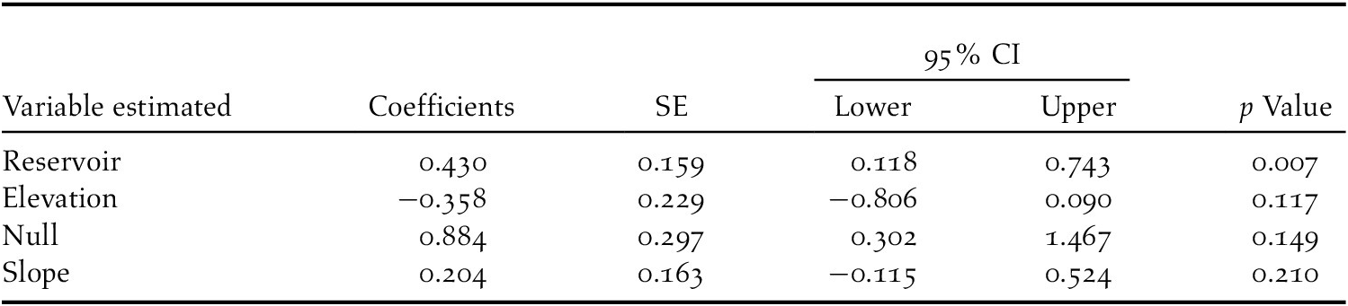
On the contrary, elevation appeared not to have had a significant influence on the Great Argus density at our site (Table 1). Higher species density was predicted at low elevations; however, 95% of the predictions overlapped zero (Table 2). Despite ranging up to 1,200 m elsewhere in its range, the species have shown a preference for low elevations with gentle slopes at a micro scale for use as a dancing ground during their breeding season (Davison Reference Davison1981, Nijman Reference Nijman1998, Dawrueng et al. Reference Dawrueng, Ngoprasert, Gale, Browne and Savini2017).
Estimation results of the abundance models for Great Argus.

Previous research in KSWS (Gibson et al. Reference Gibson, Lynam, Bradshaw, Fangliang, Bickford, Woodruff, Bumrungsri and Laurance2013, Irving et al. Reference Irving, Round, Savini, Lynam and Gale2018) showed a long-term loss of resident mammals and generalist bird species from islands that emerged after the establishment of the artificial reservoir. Our results showed that the degradation caused by the reservoir also affected species on the mainland. Although the species’ density generally declined closer to the reservoir shore, where degradation was higher, this effect was less severe in areas near ranger stations with less human disturbance. This result highlights the importance of extensive patrolling along the reservoir and forest edge.
The hydropower development resulted in the degradation of the natural forest and alterations to the habitat structure and composition (Lees et al. Reference Lees, Peres, Fearnside, Schneider and Zuanon2016, Gibson et al. Reference Gibson, Wilman and Laurance2017), threatening the local wildlife. The forest cover changed to high succession plants (Ferreira et al. Reference Ferreira, Neckel-Oliveira, Galatti, Faveri and Parolin2012), and grasses dominated the areas with no tree coverage.
In tropical forests, bamboos usually dominate other structural components following logging (Söderström and Calderon Reference Söderström and Calderon1979, Gardner et al. Reference Gardner, Sidisunthorn and Anusarnsunthorn2000). Bamboos were observed mostly in areas near the reservoir shoreline both on the mainland and islands of the KSWS. They produce substantial amounts of leaf litter (Zhou et al. Reference Zhou, Fu, Xie, Yang and Li2005), which decreases seedling abundance and local plant species richness (Larpkern et al. Reference Larpkern, Moe and Totland2011). This reduction in structural diversity threatens the diversity of bird communities in the area (Irving et al. Reference Irving, Round, Savini, Lynam and Gale2018). The reduction in structural diversity combined with the steep slope closer to the reservoir shore resulted in a low density of the species. We can therefore affirm that our result on the status of Great Argus is the indirect effect of the forest inundation following the formation of the artificial reservoir (Nakhasathien Reference Nakhasathien1987, Woodruff Reference Woodruff2013).
The Khlong Saeng Wildlife Sanctuary, one of 10 protected areas within the Khlong Saeng-Khao Sok forest complex, represents the largest natural habitat patch around the biodiversity-rich Isthmus of Kra and the northernmost distribution of Sundaic species in southern Thailand. Several birds (Irving et al. Reference Irving, Round, Savini, Lynam and Gale2018) and mammal species (Gibson et al. Reference Gibson, Lynam, Bradshaw, Fangliang, Bickford, Woodruff, Bumrungsri and Laurance2013), particularly specific habitat specialists, are threatened, and some have become extinct in the Khlong Saeng forest complex following the formation of the artificial reservoir. However, the relatively high density we estimated for Great Argus suggests the species may be tolerant, to a certain degree, of human disturbance but is vulnerable to edge effects close to the reservoir’s shore.
Acknowledgements
We thank the Department of National Parks, Wildlife and Plant Conservation for permission to work in Khlong Saeng Wildlife Sanctuary. The Galliformes research was funded by Cluster Program Management Organization, National Science and Technology Development Agency Thailand (P-15-50905). We thank all park rangers who helped with data collection in the field. Special thanks to T. Dawrueng and D. Khamcha for helping with data analysis. G. Irving and N. Sukumal provided useful comments on the manuscript.