


Introduction
On October 12, 2021, the International Court of Justice (ICJ, or the Court) delivered its judgment in Maritime Delimitation in the Indian Ocean (Somalia v. Kenya).Footnote 1 The Court established a single maritime boundary between the two states, delimiting the territorial sea, exclusive economic zone (EEZ), and continental shelf, including the continental shelf beyond 200 miles.
The judgment followed an earlier decision in which the Court upheld its jurisdiction against Kenya's preliminary objections.Footnote 2 The COVID-19 pandemic caused the oral hearing on the merits to be rescheduled several times. Kenya sought the “indefinite postponement” of the proceedings, but the Court ordered a hybrid format for the hearing instead. Kenya, in turn, declined to participate further in the proceedings. After the Court rendered its judgment, Kenya announced its intention not to abide by the judgment and to withdraw from the Court's compulsory jurisdiction.Footnote 3
A close examination of the judgment, including the Court's application of the established three-stage methodology for delimiting maritime boundaries, may reveal potential shifts in the methodology's application.
Background
By treaty arrangements in 1927 and 1933 (the 1927/1933 treaty arrangement), Italy and the United Kingdom fixed “with a high degree of precision” the terminal land boundary between their then colonial possessions at 1° 39′ 43.2" S and 41° 33′ 33.19" E, known as Primary Beacon 29 (PB 29).Footnote 4 When Somalia and Kenya achieved independence in 1960 and 1963, respectively, they continued to recognize PB 29. Over the ensuing decades, Kenya made periodic proclamations purporting to establish its EEZ bounded by the parallel of latitude from PB 29 extending directly eastward into the Indian Ocean. Somalia's Maritime Law of 1988, on the other hand, referenced a “straight line” bounding its territorial sea, which Somalia claimed was equivalent to an equidistance line.
In 2009 and 2014, Kenya and Somalia, respectively, made submissions to the Commission on the Limits of the Continental Shelf (CLCS) in order to establish the outer limits of their continental shelves beyond 200 nautical miles. Contemporaneous with Kenya's 2009 submission, the two states executed a Memorandum of Understanding, with each withdrawing objections to the other's submissions.Footnote 5 Following stalled negotiations, Somalia instituted the current proceedings in 2014, leading to the decision on jurisdiction in 2017 and the judgment in 2021.
The Judgment
The judgment made three primary findings addressing the alleged acquiescence to a customary maritime boundary, the establishment of the actual boundary, and any reparation due for violation of the actual boundary. The first and the third of these can easily be dispatched.
First, Kenya asserted that Somalia, over a period of years, acquiesced to Kenya's claim that the shared maritime boundary followed the parallel of latitude directly eastward from PB 29, and that an agreed boundary therefore already existed between the two.Footnote 6 In Kenya's view, Somalia's prolonged silence or failure to react when circumstances so required meant that Somalia acquiesced to Kenya's claim. The Court disagreed in light of the “high threshold for proof” and lack of “compelling evidence that Somalia clearly and consistently accepted the boundary claimed by Kenya.”Footnote 7 Next, and related, because no maritime boundary had been established, Kenya's activities in the disputed area, including oil surveying and drilling activities, did not violate Somalia's territorial sovereignty. Kenya thus did not owe reparations for any breach of international obligations.Footnote 8
The centerpiece of the judgment, however, was the Court's establishment of the entire maritime boundary between the two states.Footnote 9 The Court applied its familiar three-stage methodology in order to form the boundary in a generally southeasterly direction from PB 29.Footnote 10 The judgment could have important ramifications for how the first two stages are applied.
The first stage concerned the Court's identification of the starting point and base points to establish a provisional equidistance line. The normal baseline for measuring the breadth of the territorial sea is the low-water line.Footnote 11 PB 29 lay some 40 meters from the low-water mark, and the Court connected PB 29 to the low-water mark by a line perpendicular to the trend of the coastline, in accordance with the terms of the 1927/1933 treaty arrangement.Footnote 12 From this mark, the Court established base points on both states’ coasts to demarcate the territorial sea and to construct the provisional equidistance line for the EEZ.Footnote 13
The judgment's treatment of the 1927/1933 treaty arrangement was somewhat ambiguous. The Court claimed not to be applying it as such.Footnote 14 However, several judges’ individual opinions demonstrated how the Court, in effect, purported to use the land boundary demarcation between two former colonial powers to establish a maritime boundary between two successor states without showing how it got from point A to point B.Footnote 15
Of greater practical import, the Court's physical starting point may have had significant second-order effects. Several distinguished commentators have offered a technical critique of the judgment.Footnote 16 For example, they argued that the Court relied on outdated or imprecise British Admiralty Charts, resulting in “court-selected basepoints [that] are on average over 100 meters inland,” including a Somalian base point located on the Kenyan side of the land border.Footnote 17 If this observation is correct, then each step of the Court's analysis compounded this initial error, resulting in a territorial sea delimitation nearly 13 nautical miles offshore (rather than 12) and approximately 95 square nautical miles (325 square kilometers) of the EEZ and outer continental shelf that would have been awarded to Kenya rather than Somalia.Footnote 18
In the second stage, the Court queried whether any relevant circumstances required the adjustment of the provisional equidistance line. The judgment may portend a shift in the Court's approach to date. Kenya offered five arguments regarding why the line ought to be adjusted to achieve an equitable solution.Footnote 19 Although there is “no closed list of relevant circumstances”Footnote 20 under the Convention or in judicial practice, the Court declined to apply any such factors not rooted in geographical considerations. This reticence to apply social, economic, or security-based factors turns the second stage into a “purely geometric exercise” and reduces the Court's discretion in reaching a truly equitable outcome.Footnote 21
The one relevant circumstance the Court did apply to adjust the provisional equidistance line was a geographical consideration, but it still might prove controversial. In the ordinary course, the Court will adjust the line if a concavity in the coastline produces a “serious” or “significant” cut-off effect.Footnote 22 The existence and extent of any concavity is usually determined by examining only the coastlines of the states before the Court. As between Somalia and Kenya, “any concavity is not conspicuous.”Footnote 23 Yet the judgment looked to the coastline of a neighboring third state, Tanzania, to assess the coastlines in a “broader geographical configuration.”Footnote 24 Viewing the three together, the coastline is “undoubtedly concave,” particularly when taking into account Tanzania's Pemba Island.Footnote 25
The few cases relied upon by the majority as justification to take the Tanzanian coastline into account were distinguished on legal and factual grounds in separate opinions.Footnote 26 The Court introduced uncertainty as to what level of cut-off severity is required to equitably adjust the provisional line.Footnote 27 The adjustment created a hypothetical “grey area” of overlapping claims for which the Court declined to establish a legal regime.Footnote 28 In attempting to solve one problem, the Court seemed to create several others.
Conclusion
None of the maritime boundary delimitation cases pending on the Court's docket appears close to a final judgment on the merits.Footnote 29 Whether the judgment in Somalia v. Kenya marks a shift in the Court's application of the three-stage test is therefore a question that awaits future resolution.
Still, the technical critique concerning the base points, and the factors suggesting equitable adjustment of the provisional equidistance line, take on greater salience in the age of rising sea levels.Footnote 30 A Study Group convened under the auspices of the International Law Commission (ILC) is presently studying that very topic.Footnote 31
The only provisions of UNCLOS referring to the permanency of a boundary concern the outer limit of the continental shelfFootnote 32 and the situation of a coastline that is highly unstable due to the presence of a delta and other natural conditions.Footnote 33 Anything else—the territorial sea, the contiguous zone, or the EEZ—is potentially ambulatory.Footnote 34 Ambulatory baselines that shift in a landward movement would in theory affect the boundaries they were used to establish. This, in turn, could significantly affect the sovereignty and legal rights of the coastal states that rely upon those boundaries.Footnote 35
In 2012, the International Law Association's working committees concluded that the normal baseline is ambulatory and should not be required to be readjusted if rising sea levels affect the geography of the coastline.Footnote 36 The ILC Study Group preliminarily appears to take the same view in the interests of legal stability, security, certainty, and predictability. That view seems especially appropriate in the African context.Footnote 37
The ambulatory nature of baselines and the maritime boundaries constructed on them depends on getting it right, or as close to right as possible, in the first instance. The judgment in Somalia v. Kenya and the ensuing critiques illustrate the point.
12 OCTOBER 2021 JUDGMENT
MARITIME DELIMITATION IN THE INDIAN OCEAN (SOMALIA v. KENYA)
_________________________________
DÉLIMITATION MARITIME DANS L’OCÉAN INDIEN (SOMALIE c. KENYA)
12 OCTOBRE 2021 ARRÊT
Table of Contents
Paragraphs
Chronology of the procedure....................[1–28]
I. Geographical and historical background....................[31–34]
II. Overview of the positions of the Parties....................[35]
III. Whether Somalia has acquiesced to a maritime boundary following the parallel of latitude....................[36–89]
IV. Maritime delimitation....................[90–197]
A. Applicable law....................[92]
B. Starting-point of the maritime boundary....................[93–98]
C. Delimitation of the territorial sea....................[99–118]
D. Delimitation of the exclusive economic zone and the continental shelf within 200 nautical miles....................[119–177]
1. Delimitation methodology....................[119–131]
2. Relevant coasts and relevant area....................[132–141]
(a) Relevant coasts....................[132–137]
(b) Relevant area....................[138–141]
3. Provisional equidistance line....................[142–146]
4. Whether there is a need to adjust the provisional equidistance line....................[147–174]
5. Disproportionality test....................[175–177]
E. Question of the delimitation of the continental shelf beyond 200 nautical miles....................[178–197]
V. Alleged violations by Kenya of its international obligations....................[198–213]
Operative clause....................[214]
________________________________
INTERNATIONAL COURT OF JUSTICE
YEAR 2021
2021 12 October General List No. 161
12 October 2021
MARITIME DELIMITATION IN THE INDIAN OCEAN (SOMALIA v. KENYA)
Geographical and historical background — Somalia and Kenya adjacent States on coast of East Africa — 1927/1933 treaty arrangement between Italy and United Kingdom concerning boundaries of their territories in East Africa — Somalia and Kenya gaining independence in 1960 and 1963, respectively — Both States parties to United Nations Convention on the Law of the Sea (UNCLOS) — Both States having filed submissions with Commission on the Limits of the Continental Shelf (CLCS) to obtain recommendations on outer limits of continental shelf beyond 200 nautical miles — CLCS yet to issue recommendations.
*
Overview of the positions of the Parties — Somalia arguing for unadjusted equidistance line through all maritime areas — Kenya contending maritime boundary already agreed as Somalia acquiesced to boundary following parallel of latitude.
*
Whether Somalia acquiesced to maritime boundary following parallel of latitude.
Maritime delimitation to be effected by agreement or recourse to third party possessing competence — Agreement on maritime boundary usually in written form but other forms possible — Essential question being existence of shared understanding between States concerning boundary — High threshold for proof that maritime boundary established by acquiescence or tacit agreement — Court to examine whether compelling evidence that Kenya's claim to maritime boundary maintained consistently, consequently calling for response from Somalia, and clearly and consistently accepted by Somalia.
Whether claim of Kenya to a boundary at the parallel of latitude maintained consistently — Kenyan proclamations of 1979 and 2005 asserting boundary along parallel of latitude — Legislation of Kenya referring to boundary on median or equidistance line — Notes Verbales of Kenya in 2007 and 2008 asking Somalia to confirm agreement to boundary at parallel of latitude — 2009 Submission of Kenya to CLCS and 2009 Memorandum of Understanding (MOU) between both States recognizing existence of disputed maritime boundaries — 2014 negotiations between Parties and diplomatic correspondence of Kenya in 2014–2015 also suggesting boundary not yet agreed — No compelling evidence that claim of Kenya to boundary at parallel of latitude maintained consistently and consequently called for response from Somalia.
Whether Somalia clearly and consistently accepted claim of Kenya to a boundary at the parallel of latitude — Position of Parties during Third United Nations Conference on the Law of the Sea not indicating rejection by Somalia of equidistance as possible method of achieving equitable solution — No indication that Somalia accepted claim of Kenya during bilateral negotiations in 1980–1981 — Somalia's Maritime Law of 1988 providing for boundary in territorial sea following “a straight line towards the sea from the land as indicated on the enclosed charts” — Phrase unclear and not possible to determine its meaning without charts mentioned — 2009 MOU and Somalia's 2009 submission of preliminary information to the CLCS, 2009 letter to UN Secretary-General and 2014 objection to the consideration by CLCS of Kenya's submission all referring to unsettled maritime boundary dispute — Context of civil war depriving Somalia of fully operational government and administration between 1991 and 2005 to be taken into account — No clear and consistent acceptance by Somalia of maritime boundary at parallel of latitude.
Practice of Parties between 1979 and 2014 concerning naval patrols, fisheries, marine scientific research and oil concessions also not showing clear and consistent acceptance by Somalia of maritime boundary at parallel of latitude.
No compelling evidence that Somalia acquiesced to maritime boundary claimed by Kenya — Consequently no agreed maritime boundary between Parties at parallel of latitude.
*
Maritime delimitation. Applicable Law — UNCLOS.
Starting-point of maritime boundary — Concordant views of the Parties — Land boundary terminus defined in 1927/1933 treaty arrangement constituting starting-point of maritime boundary.
Delimitation of territorial sea — Article 15 UNCLOS — Identification of base points appropriate to geography of coasts — Disproportionate effect of tiny features — Court selecting base points solely on solid land on mainland coasts — Median line constructed constituting boundary in territorial sea.
Delimitation of exclusive economic zone and continental shelf within 200 nautical miles — Articles 74 and 83 UNCLOS — Three-stage methodology developed by Court — No reason to use other methodology in present case.
Identification of relevant coasts and relevant area — Relevant coasts being those whose projections overlap — Court using 200 nautical miles radial projections to identify relevant coasts of Somalia and Kenya — Relevant area being that in which potential entitlements of parties overlap — Relevant area in present case constituted by overlap of 200-nautical-mile radial projections from land boundary terminus.
First stage — Construction of a provisional equidistance line — Identification of appropriate base points — Provisional equidistance line constructed from endpoint boundary in territorial sea to 200 nautical miles from starting-point of maritime boundary.
Second stage — Whether relevant circumstances calling for adjustment of provisional equidistance line — Current security situation in Somalia and in adjacent maritime spaces not justifying adjustment — No adjustment needed to ensure equitable access to fisheries resources — No de facto boundary justifying adjustment — Question whether use of equidistance line producing cut-off effect for Kenya as result of configuration of coastline — Need to consider broader geographical configuration — Cut-off of Kenya's maritime entitlements due to concavity of coastline from Somalia to Tanzania — Pemba island accentuating cut-off effect — Need to adjust the provisional equidistance line by shifting it north — Adjusted line following geodetic line with initial azimuth 114º until intersection with 200-nautical-mile limit from coast of Kenya.
Third stage — Verification of absence of significant disproportion between ratio lengths relevant coasts and ratio respective shares of Parties in relevant area — No significant disproportionality in present case — Adjusted line achieving equitable solution.
Question of delimitation of continental shelf beyond 200 nautical miles — Both Parties having filed submissions with CLCS and fulfilled obligations under Article 76 UNCLOS — Awaiting recommendations of CLCS to delineate outer limits of continental shelf — Lack of delineation of outer limits not in and of itself impediment to delimitation of extended continental shelf between States with adjacent coasts — Essential step in delimitation being determination of existence of entitlements to extended continental shelf and overlap of such entitlements — Both Parties claiming continental shelf up to 350 nautical miles on basis of scientific evidence, claims of Parties overlapping — Neither Party questioning existence or extent of other Party entitlement to continental shelf beyond 200 nautical miles — Both Parties requesting Court to delimit maritime boundary up to outer limit of continental shelf — Court proceeding with delimitation — Court extending geodetic line used for delimitation of exclusive economic zone and continental shelf within 200 nautical miles — Maritime boundary continuing along line up to outer limits of continental shelves to be established on basis of future recommendations of CLCS or up to area where rights of third States potentially affected.
Possible grey area of limited size — Not necessary to pronounce on applicable legal régime in the present case.
*
Alleged violations by Kenya of its international obligations — Not established that Kenya's maritime activities in disputed area not made in good faith — No violation of Somalia's sovereignty or sovereign rights and jurisdiction — No evidence that Kenya's activities jeopardized or hampered reaching of final agreement on delimitation — No violation of Article 74, paragraph 3, or Article 83, paragraph 3, of UNCLOS — Responsibility of Kenya not engaged.
JUDGMENT
Present: President Donoghue; Vice-President Gevorgian; Judges Tomka, Abraham, Bennouna, Yusuf, Xue, Sebutinde, Bhandari, Robinson, Salam, Iwasawa, Nolte; Judge ad hoc Guillaume; Registrar Gautier.
In the case concerning maritime delimitation in the Indian Ocean,
between
the Federal Republic of Somalia,
represented by
H.E. Mr. Mahdi Mohammed Gulaid, Deputy Prime Minister of the Federal Republic of Somalia,
as Agent;
H.E. Mr. Ali Said Faqi, Ambassador of the Federal Republic of Somalia to the Kingdom of Belgium, the Kingdom of the Netherlands and the Grand Duchy of Luxembourg,
as Co-Agent;
Mr. Mohamed Omar Ibrahim, Senior Adviser to the President of the Federal Republic of Somalia,
as Assistant Deputy Agent;
Mr. Paul S. Reichler, Attorney at Law, Foley Hoag LLP, member of the Bars of the United States Supreme Court and the District of Columbia,
Mr. Alain Pellet, Professor Emeritus of the University Paris Nanterre, former Chairman of the International Law Commission, member of the Institut de droit international,
Mr. Philippe Sands, QC, Professor of International Law, University College London, Barrister, Matrix Chambers, London,
Ms Alina Miron, Professor of International Law, University of Angers, Mr. Edward Craven, Barrister, Matrix Chambers, London,
as Counsel and Advocates;
Mr. Lawrence H. Martin, Attorney at Law, Foley Hoag LLP, member of the Bars of the United States Supreme Court, the District of Columbia and the Commonwealth of Massachusetts,
Mr. Yuri Parkhomenko, Attorney at Law, Foley Hoag LLP, member of the Bar of the District of Columbia,
Mr. Nicholas M. Renzler, Attorney at Law, Foley Hoag LLP, member of the Bars of the United States Supreme Court, the District of Columbia and the State of New York,
Mr. Benjamin Salas Kantor, Attorney at Law, Foley Hoag LLP, member of the Bar of the Supreme Court of the Republic of Chile,
Mr. Ysam Soualhi, Researcher, Centre Jean Bodin (CJB), University of Angers,
as Counsel;
H.E. Mr. Abukar Dahir Osman, Permanent Representative of the Federal Republic of Somalia to the United Nations,
Mr. Sulayman Mohamed Mohamoud, Attorney General of the Federal Republic of Somalia,
H.E. Mr. Yusuf Garaad Omar, Special Envoy of the President of the Federal Republic of Somalia for the Red Sea and the Gulf of Aden,
Mr. Osmani Elmi Guled, Solicitor General of the Federal Republic of Somalia,
Mr. Ahmed Ali Dahir, former Attorney General of the Federal Republic of Somalia,
Mr. Kamil Abdullahi Mohammed, Legal Adviser, Office of the Attorney General of the Federal Republic of Somalia,
Mr. Abdiqani Yasin Mohamed, Personal Assistant of the Deputy Prime Minister of the Federal Republic of Somalia,
as Advisers;
Mr. Scott Edmonds, Cartographer, International Mapping,
Ms Vickie Taylor, Cartographer, International Mapping,
as Technical Advisers, and
the Republic of Kenya,
represented by
The Honourable Paul Kihara Kariuki, Attorney-General of the Republic of Kenya,
as Agent;
H.E. Mr. Lawrence Lenayapa, Ambassador of the Republic of Kenya to the Kingdom of the Netherlands,
as Co-Agent,
THE COURT,
composed as above,
after deliberation,
delivers the following Judgment:
1. On 28 August 2014, the Government of the Federal Republic of Somalia (hereinafter “Somalia”) filed in the Registry of the Court an Application instituting proceedings against the Republic of Kenya (hereinafter “Kenya”) concerning a dispute in relation to “the establishment of the single maritime boundary between Somalia and Kenya in the Indian Ocean delimiting the territorial sea, exclusive economic zone . . . and continental shelf, including the continental shelf beyond 200 nautical miles”.
In its Application, Somalia sought to found the jurisdiction of the Court on the declarations made, pursuant to Article 36, paragraph 2, of the Statute of the Court, by Somalia on 11 April 1963 and by Kenya on 19 April 1965.
2. In accordance with Article 40, paragraph 2, of the Statute, the Registrar immediately communicated the Application to the Government of Kenya. He also notified the Secretary-General of the United Nations of the filing of the Application by Somalia.
3. By a letter dated 14 November 2014, the Registrar informed all Member States of the United Nations of the filing of the Application.
4. In conformity with Article 40, paragraph 3, of the Statute, the Registrar later notified the Member States of the United Nations, through the Secretary-General, of the filing of the Application, by transmission of the printed bilingual text.
5. Since the Court included upon the Bench no judge of Kenyan nationality, Kenya proceeded to exercise its right conferred by Article 31, paragraph 2, of the Statute to choose a judge ad hoc to sit in the case; it chose Mr. Gilbert Guillaume.
6. By an Order of 16 October 2014, the President of the Court fixed 13 July 2015 as the time-limit for the filing of the Memorial of Somalia and 27 May 2016 for the filing of the Counter-Memorial of Kenya. Somalia filed its Memorial within the time-limit so prescribed.
7. On 7 October 2015, within the time-limit set by Article 79, paragraph 1, of the Rules of Court of 14 April 1978 (as amended on 1 February 2001), Kenya raised preliminary objections to the jurisdiction of the Court and to the admissibility of the Application. In an Order of 9 October 2015, the Court noted that, by virtue of Article 79, paragraph 5, of the Rules of Court of 14 April 1978 (as amended on 1 February 2001), the proceedings on the merits were suspended. Consequently, taking account of Practice Direction V, it fixed, by the same Order, 5 February 2016 as the time-limit for the presentation by Somalia of a written statement of its observations and submissions on the preliminary objections raised by Kenya. Somalia filed such a statement within the time-limit so prescribed, and the case became ready for hearing in respect of the preliminary objections.
8. Pursuant to the instructions of the Court under Article 43, paragraph 1, of the Rules of Court, the Registrar addressed to States parties to the United Nations Convention on the Law of the Sea (hereinafter “UNCLOS” or the “Convention”) the notifications provided for in Article 63, paragraph 1, of the Statute. In addition, the Registrar addressed to the European Union, which is also party to that Convention, the notification provided for in Article 43, paragraph 2, of the Rules of Court, and asked that organization whether or not it intended to furnish observations under that provision. In response, the Director-General of the Legal Service of the European Commission indicated that the European Commission, acting on behalf of the European Union, did not intend to submit observations in the case.
9. By a communication dated 21 January 2016, the Government of the Republic of Colombia, referring to Article 53, paragraph 1, of the Rules of Court, asked to be furnished with copies of the pleadings and documents annexed in the case. Having ascertained the views of the Parties in accordance with that same provision, and having taken into account the objection raised by one Party, the Court decided that it would not be appropriate to grant that request. By a letter dated 17 March 2016, the Registrar duly communicated that decision to the Government of Colombia and to the Parties.
10. Public hearings on the preliminary objections raised by Kenya were held from 19 to 23 September 2016. By its Judgment of 2 February 2017 (hereinafter the “2017 Judgment”), the Court rejected the preliminary objections raised by Kenya, and found that it had jurisdiction to entertain the Application filed by Somalia on 28 August 2014 and that the Application was admissible.
11. By an Order of 2 February 2017, the Court fixed 18 December 2017 as the time-limit for the filing of the Counter-Memorial of Kenya. That pleading was filed within the time-limit thus prescribed.
12. By an Order of 2 February 2018, the Court authorized the submission of a Reply by Somalia and a Rejoinder by Kenya, and fixed 18 June 2018 and 18 December 2018 as the respective time-limits for the filing of those pleadings. The Reply and Rejoinder were filed within the time-limits thus prescribed.
13. By letters dated 26 February 2019, the Parties were informed that the hearings on the merits would take place from 9 to 13 September 2019. By a letter dated 2 September 2019, received under cover of a Note Verbale dated 3 September 2019, Kenya requested the Court to postpone the hearings by 12 months. By a letter dated 4 September 2019, Somalia responded that it considered the request “manifestly unjustified, harmful to the judicial process and the peaceful resolution of a longstanding dispute, and highly prejudicial to [it]”. By letters dated 5 September 2019, the Parties were notified that the Court had decided to postpone the opening of the hearings to 4 November 2019.
By a letter dated 16 September 2019, Kenya requested the Court to reconsider its decision of 5 September 2019 and postpone the oral proceedings until September 2020. By a letter dated 19 September 2019, Somalia argued that there was no basis for the Court to reconsider its decision. By a letter dated 23 September 2019, Kenya reiterated its request. On 3 October 2019, the Vice-President of the Court, Acting President in the case, met the representatives of the Parties in order to ascertain their views with regard to the question of the postponement of the oral proceedings. By letters dated 16 October 2019, the Parties were informed that the Court had decided to postpone the opening of the hearings to 8 June 2020.
14. By a letter dated 23 April 2020, Kenya requested an indefinite postponement of the oral proceedings in light of the COVID-19 pandemic. By a letter dated 1 May 2020, Somalia opposed the further postponement of the oral proceedings. By letters dated 19 May 2020, the Parties were informed that the Court had decided to postpone the hearings to the week of 15 March 2021, and a detailed schedule for the hearings was provided to them.
15. By letters dated 23 December 2020, the Parties were informed that, in light of the restrictions in place across the globe as a result of the COVID-19 pandemic, the hearings due to open on 15 March 2021 would be held by video link. A modified detailed schedule was transmitted to them at the same time.
16. By a letter dated 28 January 2021, Kenya, referring to “serious difficulties in preparing for the hearing due to the ongoing global COVID-19 pandemic” and expressing concerns about proceeding with hearings by video link, requested “that the hearing be postponed until such a time as the pandemic conditions would have subsided”. By a letter dated 3 February 2021, Somalia objected to this request. Further communications on the subject were exchanged between the Parties. By letters dated 12 February 2021, the Parties were informed that the Court had decided to maintain the hearings as scheduled, starting on 15 March 2021, in a hybrid format, with some judges attending the oral proceedings in person in the Great Hall of Justice and others participating remotely by video link, and with the representatives of the Parties to the case participating either in person or by video link.
17. On 5 March 2021, Kenya presented a request to produce “new documentation and evidence”. Enclosed with Kenya's letter were Appendix 1, accompanied by two annexes, and Appendix 2, consisting of eight volumes with annexes. Kenya's letter stated that Volume I of Appendix 2 explained “the nature and relevance of the new and additional evidence”. By a letter dated 9 March 2021, Somalia informed the Court that it did not object to the production of the materials that Kenya wished to submit, except for Volume I of Appendix 2. With respect to Volume I of Appendix 2, Somalia indicated, however, that it would withdraw its objection if it were given the opportunity to respond to it.
18. By letters dated 11 March 2021, the Parties were informed that, in light of the absence of an objection on the part of Somalia and pursuant to Article 56, paragraph 1, of the Rules of Court, the documents contained in Appendix 1 and in Volumes II to VIII of Appendix 2 could be produced and would form part of the case file. Having considered the views of the Parties and the particular circumstances of the case, the Court decided to authorize the production of Volume I of Appendix 2 (hereinafter “Appendix 2”) by Kenya, on the understanding that Somalia would have the opportunity to comment thereon during the hearings. In addition, the Court decided that if Somalia wished to comment in writing on the materials that were produced by Kenya and to submit documents in support of its comments, it should do so no later than 22 March 2021. Somalia commented on these materials during the hearings and filed written comments on 22 March 2021.
19. By a letter dated 11 March 2021 and received in the Registry on 12 March 2021, the Agent of Kenya informed the Court that his Government would not be participating in the hearings in the case and indicated the reasons for that decision. The Agent requested the opportunity to address the Court orally before the commencement of the hearings and to submit a “position paper”, a copy of which was enclosed with his letter. By a letter dated 12 March 2021, Somalia objected to the two requests made by the Agent of Kenya. By letters dated 15 March 2021, the Parties were informed that the Court had decided not to grant either of the two requests made by Kenya.
20. By a letter dated 15 March 2021, the Co-Agent of Kenya stated that “while affirming that it [would] not participate in the hearings on the merits, Kenya wishe[d] to inform the Court that it nevertheless intend[ed] to utilize thirty minutes out of the time allocated to it on the 18th March, 2021, to orally address the Court”. Somalia responded by a letter of the same date, stating that it welcomed Kenya's decision to participate in the hearings. By letters dated 16 March 2021, the Parties were informed that the Court was prepared to give Kenya the opportunity to address it on 18 March 2021 (during the session originally scheduled for Kenya's oral pleadings), for the purpose of Kenya's participation in the oral proceedings and the presentation of its contentions on the merits of the case. By a letter dated 17 March 2021, Kenya indicated that it would “not utilize the opportunity provided by the Court” to participate in the oral proceedings on 18 March 2021.
21. By a letter dated 18 March 2021, Kenya submitted four new documents “for the Court's information and consideration”. By a letter dated 22 March 2021, Somalia argued that these documents were neither new nor critical and were of no probative value in support of Kenya's arguments. By letters dated 23 March 2021, the Parties were informed that the Court had decided that these four new documents and Somalia's observations thereon would be included in the case file.
22. Pursuant to Article 53, paragraph 2, of its Rules, the Court, after ascertaining the views of the Parties, decided that copies of the pleadings and documents annexed would be made accessible to the public on the opening of the oral proceedings. It also decided that the additional materials submitted by Kenya prior to and during the hearings and the written comments of Somalia thereon (see paragraphs 17, 18 and 21 above) would be made public.
23. Public hearings were held from 15 to 18 March 2021, at which the Court heard the oral arguments of:

24. At the hearings, a Member of the Court put a question to Somalia, to which a reply was given in writing, in accordance with Article 61, paragraph 4, of the Rules of Court. Pursuant to Article 72 of the Rules of Court, Kenya was invited to submit any comments that it might wish to make on Somalia's reply, but no such comments were made.
*
25. In the Application, the following claims were presented by Somalia:
“The Court is asked to determine, on the basis of international law, the complete course of the single maritime boundary dividing all the maritime areas appertaining to Somalia and to Kenya in the Indian Ocean, including in the continental shelf beyond 200 [nautical miles].
Somalia further requests the Court to determine the precise geographical co-ordinates of the single maritime boundary in the Indian Ocean.”
26. In the written proceedings, the following submissions were presented by the Parties:
On behalf of the Government of Somalia,
in the Memorial:
“On the basis of the facts and law set forth in this Memorial, Somalia respectfully requests the Court:
1. To determine the complete course of the maritime boundary between Somalia and Kenya in the Indian Ocean, including in the continental shelf beyond 200 [nautical miles], on the basis of international law.
2. To determine the maritime boundary between Somalia and Kenya in the Indian Ocean on the basis of the following geographical coordinates:

3. To adjudge and declare that Kenya, by its conduct in the disputed area, has violated its international obligations to respect the sovereignty, and sovereign rights and jurisdiction of Somalia, and is responsible under international law to make full reparation to Somalia, including inter alia by making available to Somalia all seismic data acquired in areas that are determined by the Court to be subject to the sovereignty and/or sovereign rights and jurisdiction of Somalia, and to repair in full all damage that has been suffered by Somalia by the payment of appropriate compensation.

(All points referenced are referred to WGS-84)”.
in the Reply:
“On the basis of the facts and law set forth in its Memorial and this Reply, Somalia respectfully requests the Court:
1. To reject Submissions 1 and 2 of Kenya's Counter-Memorial.
2. To determine the complete course of the maritime boundary between Somalia and Kenya in the Indian Ocean, including in the continental shelf beyond 200 [nautical miles], on the basis of international law.
3. To determine the maritime boundary between Somalia and Kenya in the Indian Ocean on the basis of the following geographical coordinates:
4. To adjudge and declare that Kenya, by its conduct in the disputed area, has violated its international obligations and is responsible under international law to make full reparation to Somalia, including inter alia by making available to Somalia all seismic, geologic, bathymetric and other technical data acquired in areas that are determined by the Court to be subject to the sovereignty and/or sovereign rights and jurisdiction of Somalia, and to repair in full all damage that has been suffered by Somalia by the payment of appropriate compensation.

(All points referenced are referred to WGS-84)”.
On behalf of the Government of Kenya,
in the Counter-Memorial:
“On the basis of the facts and law set forth in this Counter-Memorial, Kenya respectfully requests the Court to:
1. Dismiss the requests in paragraphs 2 and 3 of the Submissions at pages 147 and 148 of Somalia's Memorial dated 13 July 2015.
2. Adjudge and declare that the maritime boundary between Somalia and Kenya in the Indian Ocean shall follow the parallel of latitude at 1° 39′ 43.2" S, extending from Primary Beacon 29 (1° 39′ 43.2" S) to the outer limit of the continental shelf.”
in the Rejoinder:
“On the basis of the facts and law set forth in this Rejoinder, Kenya respectfully requests the Court to:
1. Dismiss the requests in paragraphs 1, 3 and 4 of [the Submissions in] the Reply of Somalia.
2. Adjudge and declare that the maritime boundary between Somalia and Kenya in the Indian Ocean shall follow the parallel of latitude at 1° 39′ 43.2" S, extending from Primary Beacon 29 (1° 39′ 43.2" S) to the outer limit of the continental shelf.”
27. At the oral proceedings, the following submissions were presented on behalf of the Government of Somalia at the hearing of 18 March 2021:
“On the basis of its Memorial of 7 July 2015, its Reply of 18 June 2018, and its oral pleadings, Somalia respectfully requests the Court:
1. To reject Submissions 1 and 2 of Kenya's Rejoinder of 18 December 2018.
2. To determine the complete course of the maritime boundary between Somalia and Kenya in the Indian Ocean, including in the continental shelf beyond 200 [nautical miles], on the basis of international law.
3. To determine the maritime boundary between Somalia and Kenya in the Indian Ocean on the basis of the following geographical coordinates (all points referenced are referred to WGS-84):
4. To adjudge and declare that Kenya, by its conduct in the disputed area, has violated its international obligations and is responsible under international law to make full reparation to Somalia, including inter alia by making available to Somalia all seismic, geologic, bathymetric and other technical data acquired in areas that are determined by the Court to be subject to the sovereignty and/or sovereign rights and jurisdiction of Somalia.”

28. Since Kenya did not participate in the oral proceedings, no formal submissions were presented on behalf of its Government at the hearings.
*
* *
29. The Court regrets Kenya's decision not to participate in the oral proceedings held in March 2021. Nevertheless, the Court had extensive information about Kenya's views, having received its Counter-Memorial and Rejoinder, as well as numerous volumes containing additional evidence and arguments it submitted to the Court in March 2021 (see paragraphs 17, 18 and 21 above).
30. The Court recalls that the oral proceedings were conducted in a hybrid format, in accordance with Article 59, paragraph 2, of the Rules of Court and on the basis of the Court's Guidelines for the Parties on the Organization of Hearings by Video Link, adopted on 13 July 2020 and communicated to the Parties on 12 February 2021. Prior to the opening of the hybrid hearings, the Parties were invited to participate in comprehensive technical tests, and Somalia did so. During the oral proceedings, a number of judges were present in the Great Hall of Justice, while others joined the proceedings via video link, allowing them to view and hear the speaker and see any demonstrative exhibits displayed. Each Party was permitted to have up to four representatives present in the Great Hall of Justice at any one time and was offered the use of an additional room in the Peace Palace from which members of the delegation were able to participate via video link. Members of the delegations were also given the opportunity to participate via video link from other locations of their choice.
*
* *
I. Geographical and historical background
31. Somalia and Kenya are adjacent States on the coast of East Africa. Somalia is located in the Horn of Africa. It borders Kenya to the south-west, Ethiopia to the west and Djibouti to the north-west. Somalia's coastline faces the Gulf of Aden to the north and the Indian Ocean to the east. Kenya, for its part, shares a land boundary with Somalia to the north-east, Ethiopia to the north, South Sudan to the north-west, Uganda to the west and Tanzania to the south. Its coastline faces the Indian Ocean (see sketch-map No. 1 below).
32. On 15 July 1924, Italy and the United Kingdom concluded a treaty regulating certain questions concerning the boundaries of their respective territories in East Africa, including what Somalia describes as “the Italian colony of Jubaland”, located in present-day Somalia, and the British colony of Kenya. By an Exchange of Notes dated 16 and 26 June 1925, the boundary between the Italian and British colonial territories was redefined in its southernmost section. Between 1925 and 1927, a joint British-Italian commission surveyed and demarcated the boundary. Following the completion of this exercise, the commission recorded its decisions in an Agreement signed by British and Italian representatives on 17 December 1927 (hereinafter the “1927 Agreement”). That Agreement was formally confirmed by an Exchange of Notes of 22 November 1933 between the British and Italian Governments. The Court will collectively refer to the 1927 Agreement and this Exchange of Notes as the “1927/1933 treaty arrangement”. Somalia and Kenya gained their independence in 1960 and 1963, respectively.
33. Both Parties signed UNCLOS on 10 December 1982. Kenya and Somalia ratified it on 2 March 1989 and 24 July 1989, respectively, and the Convention entered into force for them on 16 November 1994.

34. Both Somalia and Kenya have filed submissions with the Commission on the Limits of the Continental Shelf (hereinafter the “CLCS” or the “Commission”) in order to obtain its recommendations on matters related to the establishment of the outer limits of their continental shelves beyond 200 nautical miles, in accordance with Article 76, paragraph 8, of UNCLOS. While they previously objected to the consideration by the Commission of each other's submissions, these objections were subsequently withdrawn. As of the date of the present Judgment, the Commission has yet to issue its recommendations in respect of the Parties’ submissions.
II. Overview of the positions of the Parties
35. The Parties have adopted fundamentally different approaches to the delimitation of the maritime areas. Somalia argues that no maritime boundary exists between the two States and asks the Court to plot a boundary line using the equidistance/special circumstances method (for the delimitation of the territorial sea) and the equidistance/relevant circumstances method (for the maritime areas beyond the territorial sea). In its view, an unadjusted equidistance line throughout all maritime areas achieves the equitable result required by international law. Kenya, for its part, contends that there is already an agreed maritime boundary between the Parties, because Somalia has acquiesced to a boundary that follows the parallel of latitude at 1° 39′ 43.2" S (hereinafter “the parallel of latitude”). Kenya further contends that the Parties have considered this to be an equitable delimitation, in light of both the geographical context and regional practice. Kenya submits that, even if the Court were to conclude that there is no maritime boundary in place, it should delimit the maritime areas following the parallel of latitude, and that, even if the Court were to employ the delimitation methodology suggested by Somalia, the outcome, following adjustment to reach an equitable result, would be a delimitation that follows the parallel of latitude (see sketch-map No. 2 below, depicting the maritime boundaries claimed by the Parties).

III. Whether Somalia has acquiesced to a maritime boundary following the parallel of latitude
36. The Court will first ascertain whether there is an agreed maritime boundary between the Parties on the basis of acquiescence by Somalia.
* *
37. Kenya maintains that Somalia has acquiesced to its claim that the maritime boundary between the Parties follows the parallel of latitude and that there is thus an agreed boundary between them. According to Kenya, acquiescence requires three elements: first, a course of conduct or omission by one State indicative of its view regarding the content of the applicable legal rule; secondly, another State's knowledge (actual or constructive) of such conduct or omission; and, thirdly, a failure by the latter State, when a reaction is called for, to reject or dissociate itself within a reasonable time from the position taken by the first State. Thus, the Respondent's argument is not that a maritime boundary can result from unilateral acts, but that it can be established by consent resulting from the prolonged absence of protest against a claim. Kenya regards acquiescence as a form of consent that can be equated to tacit agreement. In support of its claim, it invokes decisions by international courts and tribunals referring to acquiescence and tacit agreement.
38. Kenya contends that by failing to respond to the Proclamation by the President of the Republic of Kenya of 28 February 1979 (hereinafter the “1979 Proclamation”; see paragraph 54 below), to the Proclamation by the President of the Republic of Kenya of 9 June 2005 (hereinafter the “2005 Proclamation”; see paragraph 61 below) and to Kenya's Submission on the Continental Shelf beyond 200 nautical miles deposited with the CLCS on 6 May 2009 (hereinafter the “2009 Submission to the CLCS”; see paragraph 65 below), Somalia has acquiesced to Kenya's claim that the maritime boundary between the Parties follows the parallel of latitude. In Kenya's view, a reaction is called for where there has been an express, official and public notification, through formal United Nations procedures, of a State's position concerning maritime delimitation and the sovereign rights of adjacent coastal States. It argues that the absence of protest in such circumstances constitutes acquiescence under international law. The Respondent asserts that if Somalia disagreed with Kenya's claim, it should have protested promptly, since circumstances such as the proximity of the States concerned and the giving of formal notice call for a quick and, in some cases, immediate response to a maritime or territorial claim. According to Kenya, Somalia continued to play an active role in international relations during its civil war; it was represented at the United Nations throughout this period and has had an internationally recognized government since 2000. Kenya argues that Somalia was thus in a position to protest against Kenya's claim.
39. Kenya states that the Applicant's failure to react immediately to the 1979 Proclamation or the 2005 Proclamation was particularly significant given that, pursuant to the 1972 Law on the Somali Territorial Sea and Ports, Somalia claimed a territorial sea extending to 200 nautical miles and, therefore, its claim of sovereignty in that area was at stake. In Kenya's view, Somalia's acquiescence was made clear by its agreement to the principle of equitable delimitation during the negotiations held at the Third United Nations Conference on the Law of the Sea and by its insistence on deleting any reference to equidistance in Articles 74 and 83 of UNCLOS, a position that was shared by other African States. Kenya considers it significant that Somalia initiated a rapprochement with Kenya in 1978 and points out that Somalia did not raise the issue of the 1979 Proclamation during bilateral meetings held between the Parties in 1980 and 1981.
40. Kenya also argues that Somalia's Maritime Law of 1988, which mentions a “straight line” in respect of the territorial sea boundary, refers to the parallel of latitude rather than an equidistance line. In addition, Kenya highlights Somalia's lack of reaction or protest when, in 2007 and 2008, Kenya sent two Notes Verbales in which it stated that it had drawn the boundaries with Somalia “using the parallel of latitude” and requested that Somalia confirm its agreement to such boundaries.
41. Kenya considers that the terms of the “Memorandum of Understanding between the Government of the Republic of Kenya and the Transitional Federal Government of the Somali Republic to grant to each other no-objection in respect of submissions on the outer limits of the continental shelf beyond 200 nautical miles to the Commission on the Limits of the Continental Shelf” (hereinafter the “MOU”), signed by the Parties in 2009, are consistent with Somalia's acquiescence. In Kenya's view, the Court has already found that the MOU does not concern the delimitation of the maritime boundary between the Parties and was intended merely to allow them to make their CLCS submissions before the relevant deadline. It adds that the reference in the MOU to an unsettled maritime boundary “dispute” concerns only the delimitation of the outer continental shelf and simply recognizes that the Parties have not yet negotiated a formal agreement.
42. Kenya contends that a letter sent by the Prime Minister of Somalia to the Secretary-General of the United Nations on 19 August 2009 did not contain a claim to an “equidistant maritime boundary” or a protest against Kenya's maritime boundary claim. It asserts that Somalia's first objection to Kenya's claim was expressed in a letter sent by the Minister for Foreign Affairs and International Cooperation of Somalia to the Secretary-General on 4 February 2014. Kenya argues that its consent to negotiate a formal delimitation agreement does not imply that Somalia has not acquiesced to its claim.
43. Furthermore, Kenya refers to “additional evidence” concerning other conduct of the Parties between 1979 and 2014, which, in its view, “confirms” Somalia's acceptance of the parallel of latitude as the maritime boundary. Kenya asserts that its naval patrols and interceptions, as well as both Parties’ conduct concerning fisheries, marine scientific research and offshore oil exploration blocks, have all been consistent with Kenya's claim. The Respondent maintains that its conduct would have called for a reaction from the Applicant, if Somalia had considered that Kenya had encroached on its maritime areas. In this regard, Kenya has submitted a number of maps, reports and other documents issued by various entities. It contends that the maps submitted by Somalia are irrelevant, either because they do not purport to show the official position of the Parties or because they are speculative or of unknown provenance.
*
44. Somalia notes that Article 15, Article 74 and Article 83 of UNCLOS make clear that delimitation is to be effected by agreement. It recognizes that a maritime boundary may be established by an agreement that is not in written form, but contends that a maritime boundary cannot be established by unilateral acts. In this regard, Somalia maintains that Kenya has not explained how acquiescence differs from tacit agreement. According to Somalia, even if acquiescence could be invoked as a principle of delimitation, Kenya would have to prove a prolonged and consistent course of conduct indicating its own view on the location of the maritime boundary, as well as a very definite course of conduct by Somalia showing its intention clearly and consistently to accept Kenya's claim. Somalia argues that lack of protest against a notification of a claim cannot automatically amount to an acceptance of that claim.
45. Somalia maintains that Kenya's own public statements and positions directly contradict its contention that the Parties have already delimited their maritime boundary along the parallel of latitude. In this regard, Somalia refers to Kenya's 2009 Submission to the CLCS, Kenyan domestic law, Kenya's statements to the United Nations, official Kenyan reports and presentations, the terms of the 2009 MOU, the record of the bilateral negotiations between the Parties and Kenya's pleadings before the Court in support of its preliminary objections. The Applicant adds that other States and international organizations have recognized that the maritime boundary between the Parties remains to be delimited.
46. Somalia further maintains that, in any event, it did not wait until 2014 before protesting against Kenya's claim. It contends that it articulated its claim to an equidistance line in 1974 during the Third United Nations Conference on the Law of the Sea and that this claim was embodied in its Maritime Law of 1988. Somalia asserts that “[t]he Somali language does not contain a word precisely equivalent to ‘equidistance line’ in English” and that the phrase “a straight line toward the sea from the land” in Article 4, paragraph 6, of the 1988 Law “was intended to be equivalent to an equidistance line”. The Applicant also contends that it is unreasonable and unrealistic to expect a State that was ravaged by civil war and had no functioning government to have lodged formal diplomatic protests against a purported claim to a boundary line, stressing that it protested against Kenya's claim “once it resumed having a functioning government after the long civil war”. In this regard, it draws attention to the letter sent by its Prime Minister to the Secretary-General of the United Nations on 19 August 2009, which stated, inter alia, that the continental shelf between Somalia and Kenya had not yet been delimited. Somalia adds that its opposition to a maritime boundary at the parallel of latitude, as well as its protests against Kenya's award of offshore concessions for maritime areas north of the equidistance line, were reflected in news reports published in 2012 and in a 2013 report of the Monitoring Group on Somalia and Eritrea pursuant to Security Council resolution 2060 (2012).
47. With respect to other conduct of the Parties referred to by Kenya, Somalia argues that “maritime effectivités” cannot be invoked in themselves to support the existence of a maritime boundary. In Somalia's view, Kenya's purported displays of authority in the disputed area were in any event sporadic, infrequent and recent, and were undertaken at a time when, on account of civil war, there was no functioning Somali government able to monitor such activities or exercise effective control over them. Somalia considers that the maps, reports and documents adduced by the Respondent provide no support for the existence of a maritime boundary as claimed by Kenya. It refers to other maps, asserting that they either depict an equidistant maritime boundary or show Kenya's northernmost concession blocks following a course that closely resembles an equidistance line. The Applicant contends that, in any event, even the consistent conduct of two States over a long period of time is not sufficient evidence of an agreement.
* *
48. The Court recalls that both Kenya and Somalia are parties to UNCLOS. For the delimitation of the territorial sea, Article 15 of the Convention provides for the use of a median line “failing agreement between [the two States] to the contrary”, unless “it is necessary by reason of historic title or other special circumstances to delimit the territorial seas of the two States in a [different] way”. The delimitation of the exclusive economic zone and the continental shelf is governed by Article 74, paragraph 1, and Article 83, paragraph 1, of the Convention, respectively. The Court has noted that “[t]he texts of these provisions are identical, the only difference being that Article 74 refers to the exclusive economic zone and Article 83 to the continental shelf” (Maritime Dispute (Peru v. Chile), Judgment, I.C.J. Reports 2014, p. 65, para. 179). They establish that delimitation “shall be effected by agreement on the basis of international law”.
49. The Court reiterates that maritime delimitation between States with opposite or adjacent coasts must be effected by means of an agreement between them, and that, where such an agreement has not been achieved, delimitation should be effected by recourse to a third party possessing the necessary competence (Delimitation of the Maritime Boundary in the Gulf of Maine Area (Canada/United States of America), Judgment, I.C.J. Reports 1984, p. 299, para. 112 (1)). Maritime delimitation cannot be effected unilaterally by either of the States concerned (ibid.; Continental Shelf (Tunisia/Libyan Arab Jamahiriya), Judgment, I.C.J. Reports 1982, p. 66, para. 87; Fisheries (United Kingdom v. Norway), Judgment, I.C.J. Reports 1951, p. 132).
50. An agreement establishing a maritime boundary is usually expressed in written form. The Court considers, however, that the “agreement” referred to in Article 15, Article 74, paragraph 1, and Article 83, paragraph 1, of the Convention may take other forms as well. The essential question is whether there is a “shared understanding” between the States concerned regarding their maritime boundaries (see Maritime Dispute (Peru v. Chile), Judgment, I.C.J. Reports 2014, p. 23, para. 43, and p. 31, para. 69). The Court notes that both Parties recognize that the delimitation of maritime boundaries requires such a shared understanding.
51. The jurisprudence relating to acquiescence and tacit agreement may be of assistance when examining whether there exists an agreement that is not in written form regarding the maritime boundary between two States. In this regard, the Court recalls that “acquiescence is equivalent to tacit recognition manifested by unilateral conduct which the other party may interpret as consent” (Delimitation of the Maritime Boundary in the Gulf of Maine Area (Canada/United States of America), Judgment, I.C.J. Reports 1984, p. 305, para. 130; see also Land, Island and Maritime Frontier Dispute (El Salvador/Honduras: Nicaragua intervening), Judgment, I.C.J. Reports 1992, p. 577, para. 364). If the circumstances are such that the conduct of the other State calls for a response, within a reasonable period, the absence of a reaction may amount to acquiescence (Sovereignty over Pedra Branca/Pulau Batu Puteh, Middle Rocks and South Ledge (Malaysia/Singapore), Judgment, I.C.J. Reports 2008, pp. 50–51, para. 121; Temple of Preah Vihear (Cambodia v. Thailand), Merits, Judgment, I.C.J. Reports 1962, p. 23). This is based on the principle “[q]ui tacet consentire videtur si loqui debuisset ac potuisset” (ibid.). In determining whether a State's conduct calls for a response from another State, it is important to consider whether the State has consistently maintained that conduct (Fisheries (United Kingdom v. Norway), Judgment, I.C.J. Reports 1951, pp. 138–139). In evaluating the absence of a reaction, duration may be a significant factor (see e.g. Sovereignty over Pedra Branca/Pulau Batu Puteh, Middle Rocks and South Ledge (Malaysia/Singapore), Judgment, I.C.J. Reports 2008, pp. 95–96, paras. 274–276; Land, Island and Maritime Frontier Dispute (El Salvador/Honduras: Nicaragua intervening), Judgment, I.C.J. Reports 1992, pp. 408–409, para. 80; Temple of Preah Vihear (Cambodia v. Thailand), Merits, Judgment, I.C.J. Reports 1962, p. 32).
52. The Court has set a high threshold for proof that a maritime boundary has been established by acquiescence or tacit agreement. It has emphasized that since “[t]he establishment of a permanent maritime boundary is a matter of grave importance”, “[e]vidence of a tacit legal agreement must be compelling” (Territorial and Maritime Dispute between Nicaragua and Honduras in the Caribbean Sea (Nicaragua v. Honduras), Judgment, I.C.J. Reports 2007 (II), p. 735, para. 253; see also Maritime Dispute (Peru v. Chile), Judgment, I.C.J. Reports 2014, pp. 38–39, para. 91; Delimitation of the Maritime Boundary in the Atlantic Ocean (Ghana/Côte d’Ivoire), Judgment, ITLOS Reports 2017, p. 70, para. 212). Acquiescence “presupposes clear and consistent acceptance” of another State's position (Delimitation of the Maritime Boundary in the Gulf of Maine Area (Canada/United States of America), Judgment, I.C.J. Reports 1984, p. 309, para. 145). To date, the Court has recognized the existence of a tacit agreement delimiting a maritime boundary in only one case, in which the parties had “acknowledge[d] in a binding international agreement that a maritime boundary already exist[ed]” (Maritime Dispute (Peru v. Chile), Judgment, I.C.J. Reports 2014, p. 38, para. 90). In the present case, the Court will use the criteria it has identified in earlier cases and examine whether there is compelling evidence that Kenya's claim to a maritime boundary at the parallel of latitude was maintained consistently and, consequently, called for a response from Somalia. It will then consider whether there is compelling evidence that Somalia clearly and consistently accepted the boundary claimed by Kenya.
53. In this respect, the Parties present arguments regarding Kenya's 1979 Proclamation, 2005 Proclamation, 2009 Submission to the CLCS and their respective domestic laws. They also refer to other conduct of the Parties in the period between 1979 and 2014. The Court will examine these arguments in turn.
*
54. In the 1979 Proclamation, the President of Kenya declared:
“1. That notwithstanding any rule of law or any practice which may hitherto have been observed in relation to Kenya or the waters beyond or adjacent to the territorial Sea of Kenya, the Exclusive Economic Zone of the Republic of Kenya extend[s] across the sea to a distance of two hundred nautical miles measured from the appropriate base line from where the territorial sea is measured as indicated in the Map annexed to this Proclamation. Without prejudice to the foregoing, the Exclusive Economic Zone of Kenya shall:
(a) in respect of its southern territorial waters boundary with the United Republic of Tanzania be an eastern latitude north of Pemba island to start at a point obtained by the northern intersection of two arcs one from the Kenya Lighthouse at Mpunguti ya Juu, and the other from Pemba island Lighthouse at Ras Kigomasha.
(b) in respect of its northern territorial waters boundary with [the] Somali Republic be on eastern latitude South of Diua Damasciaca Island being latitude 1° 38′ South.
2. That this Proclamation shall not affect or be in derogation of the vested rights of the Republic of Kenya over the Continental Shelf as defined in the Continental Shelf Act 197[5].
3. All States shall, subject to the applicable laws and regulations of Kenya, enjoy in the Exclusive Economic Zone the freedom of navigation and overflight and of the laying of sub-marine cables and pipelines and other internationally lawful recognized uses of the sea related to navigation and communication.
4. That the scope and regime of the Exclusive Economic Zone shall be as defined in the schedule attached to this Proclamation.”
55. This Proclamation was transmitted by the Secretary-General to the Permanent Missions of the Member States of the United Nations on 19 July 1979.
56. The 1979 Proclamation was concerned with Kenya's exclusive economic zone. It stated that “the Exclusive Economic Zone of Kenya shall . . . in respect of its northern territorial waters boundary with [Somalia] be on . . . latitude 1° 38′ South”.
57. The Court notes that Kenya's Territorial Waters Act of 1972 had established in its Section 2, subsection 1, that “[e]xcept as provided in subsection (4) of this section the breadth of the territorial waters of the Republic of Kenya shall be twelve nautical miles”. Subsection 4 had stated that “[o]n the coastline adjacent to neighbouring States the breadth of the territorial sea shall extend to a Median Line”. The Territorial Waters Act was revised in 1977, but the text of Section 2, subsection 4, remained the same. The Act remained in force when the 1979 Proclamation was issued. The Court thus observes that Kenya was not consistently claiming a maritime boundary with Somalia at a parallel of latitude in all maritime areas.
58. On 25 August 1989, shortly after ratifying UNCLOS, Kenya adopted the Maritime Zones Act (hereinafter the “1989 Maritime Zones Act”), which is still in force. In respect of the delimitation of the territorial sea, that Act employs similar terms to Kenya's Territorial Waters Act of 1972. Section 3, subsection 4, of the 1989 Maritime Zones Act provides:
“On the coastline adjacent to neighbouring states, the breadth of the territorial waters shall extend to [a line] every point of which is equidistant from the nearest points on the baselines from which the breadth of the territorial waters of each of [the] respective states is measured.”
As regards the delimitation of the exclusive economic zone, Section 4, subsection 4, of the Act provides that “[t]he northern boundary of the exclusive economic zone with Somalia shall be delimited by notice in the Gazette by the Minister pursuant to an agreement between Kenya and Somalia on the basis of international law”.
59. Kenya contends that Section 3, subsection 4, of the 1989 Maritime Zones Act merely reflects the terms of Article 15 of UNCLOS, which, it explains, applies “the median line in the territorial sea as a provisional method ‘failing agreement’ on delimitation”. It considers that the provision is without prejudice to the parallel of latitude boundary adopted in the 1979 Proclamation and maintains that Kenyan legislation neither asserts nor requires territorial sea delimitation based on a median line. Kenya further argues that Section 4, subsection 4, of the 1989 Maritime Zones Act simply recognizes that, notwithstanding the 1979 Proclamation, a formal agreement has not been concluded with Somalia in respect of the boundary of the exclusive economic zone.
60. The Court considers that Kenya's position is at odds with the text of the 1989 Maritime Zones Act, which refers neither to the 1979 Proclamation nor to a boundary at the parallel of latitude, for either the territorial sea or the exclusive economic zone. In respect of the exclusive economic zone, the text of Section 4, subsection 4, of the 1989 Maritime Zones Act provides that the northern boundary of the exclusive economic zone with Somalia shall be delimited pursuant to “an agreement between Kenya and Somalia”. These words stand in contrast to the text of Section 4, subsection 3, which provides that the southern boundary with Tanzania shall be “on an easterly latitude”, employing similar terms to those found in the 1979 Proclamation. Section 4, subsection 4, thus implies that, unlike the situation of the boundary between Kenya and Tanzania, Kenya considered in 1989 that there was no agreement with Somalia on their maritime boundary. The Act refers instead to an agreement to be concluded and published in the future. It was therefore reasonable for Somalia to understand Kenya's position to be that an agreement was to be negotiated and concluded at a later date.
61. Kenya's 2005 Proclamation replaced the 1979 Proclamation, while generally reaffirming its terms. With regard to the exclusive economic zone, the 2005 Proclamation modified the parallel of latitude claimed as the boundary with Somalia. Paragraph 1 of the 2005 Proclamation, in its relevant part, reads as follows:
“Without prejudice to the foregoing, the Exclusive Economic Zone of Kenya shall:
. . . . . . . . . . . . . . . . . . . . . . . . . . . . . . . . . . . . . . . . . . . . . . . . . . . . . . . . . . . . . . .
(b) In respect of its northern territorial waters boundary with [the] Somali Republic be on eastern latitude South of Diua Damascia[ca] Island being latitude 1° 39′ 34" degrees south.”
The Proclamation included two schedules, which contained co-ordinates defining the “area of the territorial waters” and the “Exclusive Economic Zone” of Kenya. In the first schedule, the northernmost point of the outer limit of Kenya's territorial sea is on the parallel of latitude. This implied that, for Kenya, the boundary of its territorial sea with Somalia also followed the same parallel of latitude. According to Kenya, the parallel of latitude was adjusted from the one in the 1979 Proclamation for greater accuracy, so that it coincided with the tangent to the southernmost islet of Diua Damasciaca.
62. On 25 April 2006, the Secretary-General notified the Member States of the United Nations and the States parties to UNCLOS that, in accordance with Article 16, paragraph 2, and Article 75, paragraph 2, of the Convention, Kenya had deposited two lists of geographical co-ordinates of points, as contained in the 2005 Proclamation. The 2005 Proclamation was subsequently published in the Law of the Sea Bulletin No. 61.
63. Kenya has also drawn the Court's attention to two Notes Verbales from the Ministry of Foreign Affairs of Kenya to the Ministry of Foreign Affairs of the Transitional Federal Government of Somalia, dated 26 September 2007 and 4 July 2008. In the Note Verbale of 26 September 2007, which concerned the process of delineation of the outer limits of its continental shelf, Kenya claimed that the maritime boundaries between the two countries “have been drawn using the parallel of latitude[], in accordance with Articles 74, 83 of the UNCLOS” and requested Somalia to confirm “that the Transitional Federal Government agrees with the way the maritime boundaries between the two countries are drawn . . . as deposited with the United Nations by the Government of the Republic of Kenya”. The aide-memoire attached to the Note Verbale stated that “the boundaries between our two countries have not been defined”. In the Note Verbale of 4 July 2008, Kenya asked the Government of Somalia “to state its position to the Government of the Republic of Kenya that the Transitional Federal Government of Somalia agrees with the maritime boundaries between the two countries as drawn and deposited with the United Nations by the Government of the Republic of Kenya”.
64. The Court observes that the Notes Verbales did not characterize the maritime boundary claimed by Kenya as an agreed boundary, but rather invited Somalia to confirm its agreement. It has not been shown that Somalia provided such confirmation.
65. In its 2009 Submission to the CLCS, Kenya states that the maritime space over which it exercises sovereignty, sovereign rights and jurisdiction was determined on the basis of the provisions of UNCLOS, “as implemented by the following legislation and proclamations: the Territorial Waters Act, 1972; the Maritime Zones Act, 1989, Cap. 371; and, the Presidential Proclamation of 9 June 2005 . . . in respect of Kenya's territorial sea and exclusive economic zone”. It also states that “the outer edge of the continental margin appurtenant to Kenya's land territory extends beyond 200 [nautical miles] measured from the territorial sea baseline”. The lists of co-ordinates and the maps included by Kenya in its submission show a single maritime boundary with Somalia at a parallel of latitude, extending beyond 200 nautical miles to the claimed outer limit of its continental shelf.
66. The Court notes that Kenya's 2009 Submission to the CLCS was made for the purpose of delineating the outer limits of its continental shelf, which is a process distinct from the delimitation of the continental shelf (Territorial and Maritime Dispute (Nicaragua v. Colombia), Judgment, I.C.J. Reports 2012 (II), p. 668, para. 125). In this regard, Kenya's submission indicates that “Kenya has overlapping maritime claims with the adjacent coastal States of Somalia to the north and with the United Republic of Tanzania to the south” and mentions that Kenya and Somalia had signed the 2009 MOU agreeing that they would not object to each other's submissions to the CLCS. The MOU provides that
“[t]he submissions made before the Commission and the recommendations approved by the Commission thereon shall not prejudice the positions of the two coastal States with respect to the maritime dispute between them and shall be without prejudice to the future delimitation of maritime boundaries in the area under dispute”.
67. As previously noted by the Court in the 2017 Judgment, the terms of the MOU suggest “that the two States recognize that they have a ‘maritime dispute’ that is ‘unresolved’” (I.C.J. Reports 2017, p. 32, para. 72) and identify the “area under dispute” as that “in which the claims of the two Parties to the continental shelf overlap, without differentiating between the shelf within and beyond 200 nautical miles” (ibid., p. 35, para. 84). They also suggest that “the Parties intended to acknowledge the usual course that delimitation would take . . . namely engaging in negotiations with a view to reaching agreement” (ibid., p. 40, para. 97). In this connection, the MOU provides that “[t]he delimitation of maritime boundaries in the areas under dispute . . . shall be agreed between the two coastal States on the basis of international law”.
68. The Court observes that Kenya's 2009 Submission to the CLCS also alludes to the lack of agreement between the Parties on the maritime boundary in the exclusive economic zone. In respect of the boundary with Tanzania, the submission explains that “[a]n agreement is in place between Kenya and Tanzania concerning the delimitation of maritime boundaries”. However, in respect of the boundary with Somalia, the submission states that the exclusive economic zone boundary “shall be delimited by notice in the Gazette by the Minister pursuant to an agreement between Kenya and Somalia on the basis of international law”, thus employing the same terms as Section 4, subsection 4, of the 1989 Maritime Zones Act. The submission also notes the existence of an “unsettled boundary line between Kenya and Somalia”. From these terms, it was reasonable for Somalia to maintain its understanding that an agreement had yet to be negotiated and concluded.
69. On 26 and 27 March 2014, at the request of the Kenyan Government, the Parties met in Nairobi to engage in negotiations on maritime delimitation. The mere fact that these negotiations took place suggests that the Parties recognized the need to delimit the maritime boundary between them (see Delimitation of the Maritime Boundary in the Atlantic Ocean (Ghana/Côte d’Ivoire), Judgment, ITLOS Reports 2017, p. 73, paras. 221–222, and p. 78, para. 243). This is confirmed by the Parties’ joint report on the negotiations, which states that they considered “several options and methods including bisector, perpendicular, median and parallel of latitude”, but that they “could not reach a consensus on the potential maritime boundary line acceptable to both countries to be adopted”. Nowhere does the report imply that there already was an agreed maritime boundary between the Parties.
70. Finally, the Court observes that Kenya's recognition that no agreement on the maritime boundary with Somalia has been reached was also reflected in its two Notes Verbales to the Secretary-General from the Permanent Mission of Kenya to the United Nations, dated 24 October 2014 and 4 May 2015, and in its statements made to the Court during the preliminary objections phase of the case.
71. In light of the foregoing, the Court concludes that Kenya has not consistently maintained its claim that the parallel of latitude constitutes the single maritime boundary with Somalia. Kenya's claim was contradicted by its Territorial Waters Act of 1972, which remained in force in 1979, its 1989 Maritime Zones Act and its 2009 Submission to the CLCS. Under these circumstances, it was reasonable for Somalia to understand that its maritime boundary with Kenya in the territorial sea, in the exclusive economic zone and on the continental shelf would be established by an agreement to be negotiated and concluded in the future. The Court thus concludes that there is no compelling evidence that Kenya's claim and related conduct were consistently maintained and, consequently, called for a response from Somalia.
*
72. The Court recalls that Kenya's claim of acquiescence is based on Somalia's alleged acceptance of a maritime boundary at the parallel of latitude, in particular through its prolonged absence of protest. The Court will address this argument of Kenya, bearing in mind the conclusion drawn above (see paragraph 71).
73. Kenya has emphasized that it issued the 1979 Proclamation while the Parties were actively participating in the negotiations held at the Third United Nations Conference on the Law of the Sea and that Somalia's lack of reaction should be assessed in light of the positions it took in that context. Discussions during the Conference on the question of the delimitation of maritime areas resulted in the adoption of Article 15, Article 74, paragraph 1, and Article 83, paragraph 1, of UNCLOS. The Court notes that the latter two provisions reflect the view held by both Kenya and Somalia during the negotiations that the delimitation of the exclusive economic zone and the continental shelf between States with adjacent or opposite coasts should be effected by agreement “in order to achieve an equitable solution”. These provisions, however, do not set forth a specific method of delimitation and it cannot be inferred from the Parties’ positions during the Conference that Somalia rejected equidistance as a possible method of achieving an equitable solution.
74. In the years immediately following Kenya's 1979 Proclamation, the Parties engaged in discussions on a variety of issues regarding their bilateral relations, such as trade and exploitation of marine resources. However, there is no indication that Somalia accepted Kenya's claim to a boundary along a parallel of latitude during that period. In this regard, Kenya has submitted minutes of a meeting held between the Vice-Presidents of the two States on 6 May 1980, but these minutes make no mention of any discussion of the Parties’ maritime boundaries or the 1979 Proclamation. The same is true of other evidence submitted by Kenya in relation to meetings held between the Parties in 1981.
75. Until 1989, Somalia did not claim an exclusive economic zone or define its continental shelf. Article 1, paragraph 1, of the 1972 Law on the Somali Territorial Sea and Ports defined Somalia's territorial sea as extending to 200 nautical miles, without including any provision pertaining to its delimitation. Shortly before ratifying UNCLOS, Somalia adopted the Maritime Law of 1988, approved by Law No. 5 on 26 January 1989. Article 7 of the Maritime Law provides that Somalia's exclusive economic zone shall extend to 200 nautical miles, and Article 8 defines its continental shelf both within and beyond 200 nautical miles. The Maritime Law does not refer to the delimitation of either of these areas. Article 4 defines Somalia's territorial sea as extending to 12 nautical miles and addresses the issue of its delimitation with Kenya, providing in the relevant part of paragraph 6:
“If there is no multilateral treaty, the Somali Democratic Republic shall consider that the border between the Somali Democratic Republic and the Republic of Djibouti and the Republic of Kenya is a straight line toward the sea from the land as indicated on the enclosed charts.”
76. Somalia has not produced the charts mentioned in the provision, explaining that they may have been lost or destroyed during the civil war. It maintains that “the phrase ‘straight line toward the sea’ was intended to be equivalent to an equidistance line”. Kenya contends that, although the meaning of this phrase is unclear, taking Somalia's contemporary practice into account, it should be interpreted as a reference to the parallel of latitude.
77. The Court notes that Article 4, paragraph 6, of the Maritime Law also refers to the delimitation of maritime areas in relation to the Republic of Yemen, employing the phrase “a median line”. The phrase “a straight line toward the sea from the land” is not clear and, without the charts mentioned, its meaning cannot be determined. Kenya submits a number of documents, including the Mining Code of the Somali Democratic Republic of 1984 and several maps, which, in its view, support its interpretation of this phrase. The text of the Mining Code, adopted prior to the Maritime Law of 1988, does not serve to clarify the meaning given by the latter to the phrase “a straight line toward the sea from the land”. Article 58 of the Mining Code concerns only the establishment of concession blocks in Somali territory. The Mining Code did not itself regulate Somalia's maritime boundaries. Similarly, the maps submitted by Kenya depict only oil concession blocks. As the Court will further explain below (see paragraphs 86 and 87), such blocks, in and of themselves, cannot be taken to indicate the existence of a maritime boundary.
78. Somalia did not react immediately to the 2005 Proclamation. However, its view was made clear on several occasions in 2009. As noted above (see paragraph 67), the MOU concluded that year between the Parties refers to an unsettled maritime dispute. Somalia's 2009 submission of preliminary information to the CLCS reproduces the text of the MOU and indicates that “[u]nresolved questions remain in relation to [the] bilateral delimitation of the continental shelf with neighbouring States”. In addition, in a letter dated 19 August 2009 and addressed to the Secretary-General of the United Nations, the Prime Minister of Somalia maintained that “[t]he delimitation of the continental shelf . . . has not yet been settled”, further stating that
“[i]t would appear that Kenya claims an area extending up to the latitude of the point where the land border reaches the coast, while, instead, in accordance with the international law of the sea, an equidistance line normally constitutes the point of departure for the delimitation of the continental shelf between two States with adjacent coasts. Somalia bases itself on the latter view”.
Furthermore, as noted by the Court in the 2017 Judgment, in 2014 Somalia “objected to the consideration by the CLCS of Kenya's submission on the ground that there existed a maritime boundary dispute between itself and Kenya” (I.C.J. Reports 2017, p. 14, para. 19). Somalia withdrew its objection in 2015, noting that the dispute had been submitted to the Court.
79. Finally, the Court cannot ignore the context of the civil war that afflicted Somalia, depriving it of a fully operational government and administration between 1991 and 2005. These circumstances were public and notorious (see e.g. Security Council, Report of the Secretary-General on the protection of Somali natural resources and waters, UN doc. S/2011/661, 25 October 2011, para. 22), and they were also recognized by Kenya in the previous phase of the proceedings. This context needs to be taken into account in evaluating the extent to which Somalia was in a position to react to Kenya's claim during this period.
80. For the foregoing reasons, the Court considers that the conduct of Somalia between 1979 and 2014 in relation to its maritime boundary with Kenya, as examined above, in particular its alleged absence of protest against Kenya's claim, does not establish Somalia's clear and consistent acceptance of a maritime boundary at the parallel of latitude.
*
81. Kenya also argues that other conduct of the Parties between 1979 and 2014 confirms Somalia's acceptance of a maritime boundary at the parallel of latitude. Kenya refers, in particular, to the Parties’ practice concerning naval patrols, fisheries, marine scientific research and oil concessions (see paragraph 43 above). The Court will now consider this argument of Kenya.
82. The Court recalls that, in the context of a maritime delimitation dispute, as for territorial disputes, the date on which the dispute crystallized is of significance. Acts occurring after such date are in principle irrelevant to the determination of a maritime boundary and cannot be taken into consideration, “having been carried out by a State which, already having claims to assert in a legal dispute, could have taken those actions strictly with the aim of buttressing those claims” (Territorial and Maritime Dispute between Nicaragua and Honduras in the Caribbean Sea (Nicaragua v. Honduras), Judgment, I.C.J. Reports 2007 (II), pp. 697–698, para. 117; see also Sovereignty over Pedra Branca/Pulau Batu Puteh, Middle Rocks and South Ledge (Malaysia/Singapore), Judgment, I.C.J. Reports 2008, pp. 27–28, para. 32; Sovereignty over Pulau Ligitan and Pulau Sipadan (Indonesia/Malaysia), Judgment, I.C.J. Reports 2002, p. 682, para. 135).
83. Kenya argues that there was no dispute between the Parties until 2014. However, when it submitted its Preliminary Objections in 2015, it stated that “[i]t was only in 2009 that Somalia first disputed Kenya's 1979 EEZ maritime boundary”. Somalia, for its part, argues that the Parties have been engaged in a maritime boundary dispute since the 1970s. The Court recalls that the MOU concluded by the Parties in 2009 and Kenya's 2009 Submission to the CLCS indicate that a maritime dispute existed between them as of 2009 (see paragraphs 66–68 above). Somalia has not provided the Court with sufficient evidence to conclude that the dispute emerged before 2009. Accordingly, the Court considers that the Parties’ activities after 2009 cannot be taken into consideration for the purpose of determining the maritime boundary.
84. In light of the foregoing, the Court will examine the conduct of the Parties referred to by Kenya. The Court begins by considering the evidence of naval patrols. Maps depicting and logs recording Kenya's naval patrols and interceptions in the territorial sea show that some law enforcement activities were conducted by Kenya north of the equidistance line claimed by Somalia. Occasionally, however, they were also conducted north of the parallel of latitude that it claims as the maritime boundary. Kenya's naval patrols and interceptions were thus not necessarily consistent with its maritime boundary claim. Moreover, one of the maps submitted by Kenya is marked “secret” and the remaining evidence does not establish that Somalia had knowledge of these activities.
85. The evidence on fisheries and marine scientific research activities also does not support Kenya's claim. Kenya submitted a fishing licence it had granted to a French vessel on 20 June 2011 for the period between July 2011 and June 2012, which included co-ordinates for fishing areas north of the equidistance line. There is no evidence, however, that Somalia had knowledge of these activities, which, in any event, took place after 2009. Kenya also submitted a report issued by the Ministry of Fisheries and Marine Transport of Somalia for the period 1987/1988, which referred to the positions studied in a survey conducted by the Intergovernmental Oceanographic Commission (hereinafter the “IOC”) of UNESCO. However, this report includes no indication of any maritime boundary. Similarly, a map published by the Ministry of Fisheries of Somalia and reproduced in a 1987 report of the United Nations Environment Programme does not depict the boundary of Somalia's southernmost fishery region or its maritime boundary with Kenya. It therefore cannot be concluded from this map that Somalia considered the maritime boundary to be established at the parallel of latitude. Other documents submitted by Kenya as evidence — including a map produced by the IOC, an offshore trawling survey of Kenya conducted by the Food and Agriculture Organization of the United Nations and the United Nations Development Programme, and a technical paper reflecting the results of a survey programme conducted in co-operation with Norwegian agencies — were not produced by the Parties and thus cannot be taken to reflect their official positions.
86. As regards oil concessions, the Parties have referred to a number of maps produced by third parties, as well as by Kenyan and Somali institutions. Kenya has also referred to the terms of Somalia's Mining Code (see paragraph 77 above) and Petroleum Law. The Court notes that the Parties have established offshore oil concession blocks employing different lines since the 1970s. However, the Parties have referred only to limited practice that took place before 2009, such as a series of contracts concluded since 2000 in relation to the oil concession block identified by Kenya as Block L-5 and the drilling of the first exploratory well slightly north of the equidistance line claimed by Somalia, between December 2006 and January 2007. For the most part, the Parties have referred to practice after 2009, which, for the reasons previously explained (see paragraphs 82 and 83 above), is irrelevant to the determination of the maritime boundary.
87. The Court notes Kenya's argument that the conduct of the Parties, including with respect to oil concessions, reflects the existence of a de facto maritime boundary. Even assuming that the limited evidence of practice before 2009 could be taken to suggest that a de facto line along the parallel of latitude may have been used by the Parties for the location of oil concession blocks, at least for some time, the Court observes that this may have been “simply the manifestation of the caution exercised by the Parties in granting their concessions” (Sovereignty over Pulau Ligitan and Pulau Sipadan (Indonesia/Malaysia), Judgment, I.C.J. Reports 2002, p. 664, para. 79). The Court also recalls that a de facto line “might in certain circumstances correspond to the existence of an agreed legal boundary or might be more in the nature of a provisional line or of a line for a specific, limited purpose, such as sharing a scarce resource” (Territorial and Maritime Dispute between Nicaragua and Honduras in the Caribbean Sea (Nicaragua v. Honduras), Judgment, I.C.J. Reports 2007 (II), p. 735, para. 253). The Court considers that “proof of the existence of a maritime boundary requires more than the demonstration of longstanding oil practice or adjoining oil concession limits” (Delimitation of the Maritime Boundary in the Atlantic Ocean (Ghana/Côte d’Ivoire), Judgment, ITLOS Reports 2017, p. 71, para. 215).
88. For the reasons set out above, the Court considers that other conduct of the Parties between 1979 and 2014 does not confirm that Somalia has clearly and consistently accepted a maritime boundary at the parallel of latitude.
*
89. In conclusion, the Court finds that there is no compelling evidence that Somalia has acquiesced to the maritime boundary claimed by Kenya and that, consequently, there is no agreed maritime boundary between the Parties at the parallel of latitude. Kenya's claim in this respect must therefore be rejected.
IV. Maritime delimitation
90. In view of the conclusion just reached, the Court will now turn to the delimitation of the maritime areas appertaining to Somalia and Kenya.
91. In its Application, Somalia requested the Court to determine, on the basis of international law, the complete course of the single maritime boundary dividing all the maritime areas appertaining to Somalia and to Kenya in the Indian Ocean, including the continental shelf beyond 200 nautical miles (see paragraph 25 above).
A. Applicable law
92. Both Somalia and Kenya are parties to UNCLOS (see paragraph 33 above). The provisions of the Convention must therefore be applied by the Court in determining the course of the maritime boundary between the two States.
B. Starting-point of the maritime boundary
93. Although the Parties initially proffered divergent views on the appropriate approach to defining the starting-point of the maritime boundary, those views evolved in the course of the proceedings and are now by and large concordant.
94. According to Somalia, the construction of the maritime boundary line begins with the identification of the land boundary terminus, which it locates at 1° 39′ 44.07" S and 41° 33′ 34.57" E. To locate the land boundary terminus, Somalia first explains that the terminal point of the Parties’ land boundary was defined with a high degree of precision in the 1927/1933 treaty arrangement between the two colonial Powers, the United Kingdom and Italy. Somalia contends that, consistent with the terms of the 1927 Agreement, the final permanent boundary beacon, known as Primary Beacon No. 29, or “PB 29”, at the location known as “Dar Es Salam”, must be connected to the low-water line by means of a straight line, perpendicular to the coast. It submits that the point at which this perpendicular line intersects the low-water line is the proper starting-point of the maritime boundary. Somalia situates this point on the low-water line approximately 41 metres south-east of PB 29. Somalia further contends that its approach to defining the starting-point of the maritime boundary is in conformity with Article 5 of UNCLOS, which states that the normal baseline for measuring the breadth of the territorial sea is the “low-water line”.
95. In its Counter-Memorial and Rejoinder, Kenya made reference to PB 29 itself as being the appropriate starting-point for the delimitation of the maritime boundary. It argued against a starting-point located on the low-water line. The Court, however, notes that subsequently, in Appendix 2, where Kenya discussed how a provisional equidistance line ought to be constructed, it stated that such a line “begins from [a land boundary terminus] on the low-water line extending south-east from PB29”. Taking these views into account, the Court can conclude that the Parties agree on the method for identifying the starting-point of the maritime boundary.
96. As to the exact location of PB 29, Somalia first argued that its co-ordinates are 1° 39′ 43.3" S and 41° 33′ 33.49" E. In its Counter-Memorial, Kenya replied that the precise co-ordinates of PB 29 are slightly different, at 1° 39′ 43.2" S and 41° 33′ 33.19" E. However, in the oral proceedings, Somalia indicated that it would be prepared to accept the co-ordinates proposed by Kenya for PB 29 for the purposes of identifying the starting-point of the maritime boundary in the Indian Ocean.
97. As to the exact location of the land boundary terminus, the Parties have put forward co-ordinates that are approximately the same. The co-ordinates for the land boundary terminus identified by Kenya by employing British Admiralty Chart 3362 — namely 1° 39′ 44.0" S and 41° 33′ 34.4" E — differ only slightly from the co-ordinates identified by Somalia using the United States National Geospatial Agency (US NGA) Nautical Chart 61220 (see paragraph 94 above). During the oral proceedings, Somalia stated that it would “be content with the outcome” regardless of which chart the Court chose to employ.
98. Taking into account the views of the Parties, the Court considers that the starting-point of the maritime boundary is to be determined by connecting PB 29 to a point on the low-water line by a straight line that runs in a south-easterly direction and that is perpendicular to “the general trend of the coastline at Dar Es Salam” in accordance with the terms of the 1927/1933 treaty arrangement. On the basis of British Admiralty Chart 3362, the Court determines that the co-ordinates for the starting-point of the maritime boundary are 1° 39′ 44.0" S and 41° 33′ 34.4" EFootnote 1 (see sketch-map No. 3 below).

C. Delimitation of the territorial sea
99. The Parties have differing views on the delimitation of the territorial sea. Somalia submits that the delimitation of the territorial sea is to be effected pursuant to Article 15 of the Convention.
100. Article 15 of the Convention, which concerns the delimitation of the territorial sea, provides:
“Where the coasts of two States are opposite or adjacent to each other, neither of the two States is entitled, failing agreement between them to the contrary, to extend its territorial sea beyond the median line every point of which is equidistant from the nearest points on the baselines from which the breadth of the territorial seas of each of the two States is measured. The above provision does not apply, however, where it is necessary by reason of historic title or other special circumstances to delimit the territorial seas of the two States in a way which is at variance therewith.”
101. Somalia maintains that a median line should constitute the maritime boundary between the Parties in the territorial sea.
102. On the basis of US NGA Nautical Chart 61220, and using the CARIS-LOTS software, Somalia has selected various base points on its side of the land boundary terminus which, according to Somalia, influence the location of the median line within 12 nautical miles. Two of these base points are located on the Diua Damasciaca islets. Base point S1 has the geographical co-ordinates 1° 39′ 43.30" S and 41° 34′ 35.40" E. For base point S2, Somalia provides the following geographical co-ordinates: 1° 39′ 35.90" S and 41° 34′ 45.29" E. The third point, S3, is located on a low-tide elevation off the southern tip of a small peninsula known as Ras Kaambooni, with the co-ordinates 1° 39′ 14.99" S and 41° 35′ 15.68" E.
103. On the Kenyan side of the land boundary, Somalia has identified two base points on the most seaward points on the charted low-tide coast. According to Somalia, these points control the median line within the territorial sea. For base point K1, Somalia provides the co-ordinates 1° 42′ 00.06" S and 41° 32′ 47.38" E; for base point K2, the co-ordinates are 1° 43′ 04.77" S and 41° 32′ 37.18" E.
104. Relying on these base points, Somalia suggests a median line in the territorial sea with five turning points as follows:

The line proposed by Somalia is depicted on sketch-map No. 4 reproduced below. As Somalia sees it, there are no “special circumstances” making this line “arbitrary, unreasonable or unworkable”, and it should therefore constitute the maritime boundary to be adopted by the Court for the delimitation of the territorial sea.
105. Kenya argued in its Counter-Memorial that the maritime boundary, including the part in the territorial sea, already exists and that it follows the parallel of latitude (see sketch-map No. 4 below). The Court has already concluded (see paragraph 89 above) that no such boundary was agreed between the Parties. Kenya, in the same written pleading, referred to the 1927/1933 treaty arrangement and stated that it “provided for the establishment of [a] boundary of the territorial sea”. Kenya drew attention to Appendix I of the 1927 Agreement, which states that the line proceeds from PB 29 “in a south-easterly direction, to the limit of territorial waters in a straight line at right angles to the general trend of the coast-line at Dar Es Salam, leaving the islets of Diua Damasciaca in Italian territory”. According to Kenya, the resulting line, which it describes as running perpendicular to the general direction of the coast “must be extended further into the territorial sea (which extended up to 3 nautical miles at the time)”.
106. Kenya has however not asked the Court to delimit any segment of the maritime boundary on the basis of the 1927/1933 treaty arrangement. In the submissions contained in its Counter-Memorial and its Rejoinder, it asks the Court to adjudge and declare that the maritime boundary follows the parallel of latitude from the starting-point to the outer limit of the continental shelf (see paragraph 26 above). It took the same position in its Appendix 2, filed just a few days before the opening of the hearings.
107. During the oral proceedings, a Member of the Court, referring to the Counter-Memorial of Kenya, asked the following question: “In Somalia's view, does th[e] 1927 Agreement establish the delimitation line of the territorial sea between the two Parties, and if so, what would be the outer limit of this line?” Somalia responded that “[n]either [it] nor Kenya, since their independence and at all times thereafter, has ever claimed that the maritime boundary in the territorial sea follows a line perpendicular to the coast at Dar es Salam, for any distance”. It further added that neither Party accepted nor argued for the 1927 Agreement as binding on them in regard to a maritime boundary, for any distance.
108. Kenya was given an opportunity to comment on Somalia's reply to the question but did not do so.
109. The Court notes that neither Party asks it to confirm the existence of any segment of a maritime boundary or to delimit the boundary in the territorial sea on the basis of the 1927/1933 treaty arrangement. It recalls that in their legislation concerning the territorial sea neither Party has referred to the terms of the 1927/1933 treaty arrangement to indicate the extent of the territorial sea in relation to its adjacent neighbour. Kenya's legislation has referred to a median or equidistance line (see paragraphs 57 and 58 above) and Somalia's Maritime Law of 1988 refers to “a straight line toward the sea from the land as indicated on the enclosed charts” (see paragraphs 75–77 above). The Court further notes that the agenda of the meeting between Somalia and Kenya, held on 26 and 27 March 2014, to discuss the maritime boundary between the two countries, covered all maritime zones, including the territorial sea. The delegations discussed “several options and methods” for determining the maritime boundary, although they could not reach an agreement. In a presentation examining an “Equity-based Maritime boundary scenario”, which is attached to the joint report on that meeting, Kenya referred to Articles 15, 74 and 83 of the Convention as relevant to maritime delimitation. It emphasized that Article 15 provides for delimitation through a “[m]edian line for [the] territorial sea unless there is an agreement to the contrary based on [a] claim by historical title and or special circumstances” (emphasis in the original). In light of the above, the Court therefore considers it unnecessary to decide whether the 1927/1933 treaty arrangement had as an objective the delimitation of the boundary in the territorial sea.
110. Kenya criticizes Somalia's choice of US NGA Nautical Chart 61220 for the selection of the base points and maintains that British Admiralty Chart 3362 should be used if a provisional equidistance line is to be constructed in the territorial sea. For the provisional equidistance line in the territorial sea, Kenya has selected the base points K1, K2, K3 and K4 and the base points S1, S2 and S3, with the following co-ordinates:
Base points on Kenya's coast:

Base points on Somalia's coast:

The line that it constructs on this basis lies slightly to the north of the line proposed by Somalia (see sketch-map No. 4 below).

111. The Court recalls that the delimitation methodology is based on the geography of the coasts of the two States concerned, and that a median or equidistance line is constructed using base points appropriate to that geography. Although in the identification of base points the Court will have regard to the proposals of the parties, it need not select a particular base point, even if the parties are in agreement thereon, if it does not consider that base point to be appropriate. The Court may select a base point that neither party has proposed (Maritime Delimitation in the Black Sea (Romania v. Ukraine), Judgment, I.C.J. Reports 2009, p. 101, paras. 116–117, p. 103, para. 123, p. 104, para. 125, and p. 108, para. 138). The Court further recalls that it “has sometimes been led to eliminate the disproportionate effect of small islands”, by not selecting a base point on such small maritime features (Maritime Delimitation and Territorial Questions between Qatar and Bahrain (Qatar v. Bahrain), Merits, Judgment, I.C.J. Reports 2001, pp. 104–109, para. 219, referring to North Sea Continental Shelf (Federal Republic of Germany/Denmark; Federal Republic of Germany/Netherlands), Judgment, I.C.J. Reports 1969, p. 36, para. 57; see also Delimitation of the Maritime Boundary in the Bay of Bengal (Bangladesh/Myanmar), Judgment, ITLOS Reports 2012, p. 47, para. 151). As the Court has stated in the past, there may be situations in which “the equitableness of an equidistance line depends on whether the precaution is taken of eliminating the disproportionate effect of certain ‘islets, rocks and minor coastal projections’” (Continental Shelf (Libyan Arab Jamahiriya/Malta), Judgment, I.C.J. Reports 1985, p. 48, para. 64).
112. The Court considers that there are serious reasons to question the appropriateness of the base points, as proposed by the Parties, that determine the course of the median line within the territorial sea.
113. The Court notes that the Parties have not selected the same base points for the delimitation of the territorial sea. Kenya has expressed doubts about the use of base points located on unknown low-tide features that have not been confirmed by a field visit. The first two base points that Somalia proposes on its side of the land boundary terminus are located on the Diua Damasciaca islets. They have a significant effect on the course of the median line in the territorial sea, pushing it to the south. Somalia's third base point, off the southern tip of Ras Kaambooni, also has the effect of significantly pushing the course of the median line to the south. Kenya maintains that this base point “appears nowhere” when base points are calculated using British Admiralty Chart 3362. On the Somali side of the starting-point, the base points that Kenya would use to construct the median line (which differ from those used by Somalia) also push the initial course of the median line to the south. The placement of base points on the tiny maritime features described above has an effect on the course of the median line that is disproportionate to their size and significance to the overall coastal geography.
114. In the circumstances of the present case, the Court considers it appropriate to place base points for the construction of the median line solely on solid land on the mainland coasts of the Parties. It does not consider it appropriate to place base points on the tiny arid Diua Damasciaca islets, which would have a disproportionate impact on the course of the median line in comparison to the size of these features. For similar reasons, the Court does not consider it appropriate to select a base point on a low-tide elevation off the southern tip of Ras Kaambooni, which is a minor protuberance in Somalia's otherwise relatively straight coastline in the vicinity of the land boundary terminus, which constitutes the starting-point for the maritime delimitation.
115. The appropriate base points selected by the Court on Somalia's coast are the following:

116. The appropriate base points selected by the Court on Kenya's coast are the following:
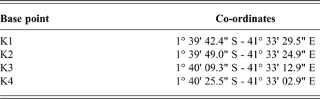
117. The resulting line starts from the land boundary terminus at co-ordinates 1° 39′ 44.0" S and 41° 33′ 34.4" E and has the following turning points:

The geographical co-ordinates of the point (Point A) at the distance of 12 nautical miles from the coast are 1° 47′ 39.1" S and 41° 43′ 46.8" E. That median line is depicted on sketch-map No. 5 below.
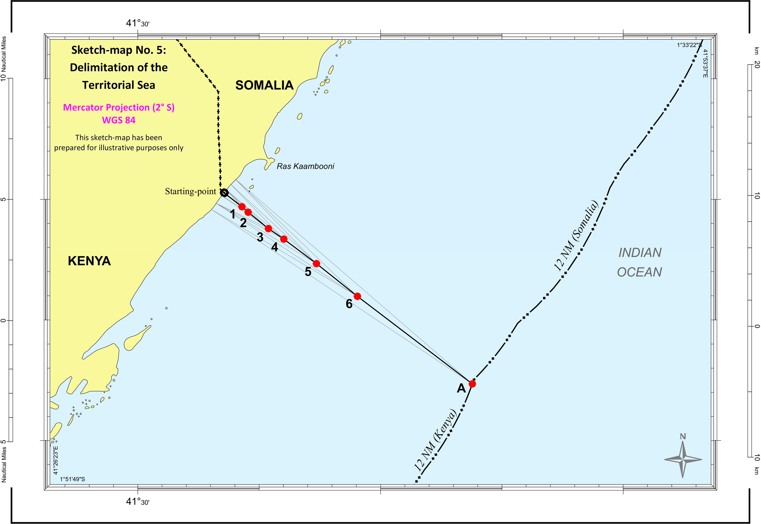
118. The Court observes that the course of the median line as described in paragraph 117 corresponds closely to the course of a line “at right angles to the general trend of the coastline”, assuming that the 1927/1933 treaty arrangement, in using this phrase, had as an objective to draw a line that continues into the territorial sea, a question that the Court need not decide (see paragraph 109 above).
D. Delimitation of the exclusive economic zone and the continental shelf within 200 nautical miles
1. Delimitation methodology
119. The Court will now proceed to the delimitation of the exclusive economic zone and the continental shelf within 200 nautical miles from the coasts of the Parties. The relevant provisions of the Convention for this exercise are contained in Article 74 of UNCLOS for the delimitation of the exclusive economic zone and Article 83 for the delimitation of the continental shelf.
Article 74, paragraph 1, provides:
“The delimitation of the exclusive economic zone between States with opposite or adjacent coasts shall be effected by agreement on the basis of international law, as referred to in Article 38 of the Statute of the International Court of Justice, in order to achieve an equitable solution.”
Article 83, paragraph 1, reads as follows:
“The delimitation of the continental shelf between States with opposite or adjacent coasts shall be effected by agreement on the basis of international law, as referred to in Article 38 of the Statute of the International Court of Justice, in order to achieve an equitable solution.”
120. In substance, these two provisions are identical, thus facilitating the establishment of a single maritime boundary delimiting two distinct maritime zones with their own specific legal régimes (see e.g. Continental Shelf (Libyan Arab Jamahiriya/Malta), Judgment, I.C.J. Reports 1985, p. 33, para. 33; Delimitation of the Maritime Boundary in the Gulf of Maine Area (Canada/United States of America), Judgment, I.C.J. Reports 1984, p. 295, para. 96).
121. The above-quoted provisions are of a very general nature and do not provide much by way of guidance for those involved in the maritime delimitation exercise. The goal of that exercise is the achievement of an “equitable solution”. If two States have freely agreed on a maritime boundary, they are deemed to have achieved such “an equitable solution”. However, if they fail to reach an agreement on their maritime boundary and the matter is submitted to the Court, it is the task of the Court to find an equitable solution in the maritime delimitation it has been requested to effect.
122. Since the adoption of the Convention, the Court has gradually developed a maritime delimitation methodology to assist it in carrying out its task. In determining the maritime delimitation line, the Court proceeds in three stages, which it described in the case concerning Maritime Delimitation in the Black Sea (Romania v. Ukraine) (Judgment, I.C.J. Reports 2009, pp. 101–103, paras. 115–122).
123. In the first stage, the Court will establish the provisional equidistance line from the most appropriate base points on the coasts of the parties. As the Court has stressed, “the line is plotted on strictly geometrical criteria on the basis of objective data” (ibid., p. 101, para. 118).
124. In accordance with Articles 74 and 83 of the Convention, the delimitation shall achieve an equitable solution. The Court has explained that “the achievement of an equitable solution requires that, so far as possible, the line of delimitation should allow the coasts of the Parties to produce their effects in terms of maritime entitlements in a reasonable and mutually balanced way” (Territorial and Maritime Dispute (Nicaragua v. Colombia), Judgment, I.C.J. Reports 2012 (II), p. 703, para. 215). The Court will therefore, in the second stage, “consider whether there are factors calling for the adjustment or shifting of the provisional equidistance line in order to achieve an equitable result” (Maritime Delimitation in the Black Sea (Romania v. Ukraine), Judgment, I.C.J. Reports 2009, p. 101, para. 120, referring to Land and Maritime Boundary between Cameroon and Nigeria (Cameroon v. Nigeria: Equatorial Guinea intervening), Judgment, I.C.J. Reports 2002, p. 441, para. 288). Various factors, referred to as “relevant circumstances”, may call for the adjustment or shifting of the provisional line. These factors are mostly geographical in nature, although there is no closed list of relevant circumstances. They are not specified in the provisions of the Convention related to delimitation, which do not use the term “relevant circumstances”. These relevant circumstances have been identified and developed in the practice of the Court, the International Tribunal for the Law of the Sea and arbitral tribunals in the context of each case. As observed by the Arbitral Tribunal in the case between Barbados and Trinidad and Tobago, the relevant circumstances are “case specific” (Arbitration between Barbados and the Republic of Trinidad and Tobago, Award of 11 April 2006, United Nations, Reports of International Arbitral Awards (RIAA), Vol. XXVII, p. 215, para. 242).
125. In the third and final stage, the Court will subject the envisaged delimitation line, either the equidistance line or the adjusted line, to the disproportionality test. The purpose of this test is to assure the Court that there is no marked disproportion between the ratio of the lengths of the relevant coasts of the parties and the ratio of the respective shares of the parties in the relevant area to be delimited by the envisaged line, and thus to confirm that the delimitation achieves an equitable solution as required by the Convention. Whether there is such a marked disproportion is a matter for the Court's appreciation in each case by reference to the overall geography of the area (Maritime Delimitation in the Black Sea (Romania v. Ukraine), Judgment, I.C.J. Reports 2009, p. 129, para. 213).
* *
126. Somalia maintains that the three-stage delimitation methodology described above is in the circumstances of this case the only appropriate method for delimiting the maritime boundary between Somalia and Kenya.
127. Kenya argues in its written pleadings that the three-stage methodology is not mandatory. It does not deny that this method may be appropriate to achieve an equitable solution in certain cases; however, in its view, it is not appropriate in the present case. Kenya submits that, in light of the applicable law, the regional geographical context and practice, and the conduct of the Parties, the parallel of latitude is the appropriate methodology to achieve an equitable solution. It contends that, in any event, the parallel of latitude provides for the most equitable delimitation in this case.
* *
128. The Court observes that the three-stage methodology is not prescribed by the Convention and therefore is not mandatory. It has been developed by the Court in its jurisprudence on maritime delimitation as part of its effort to arrive at an equitable solution, as required by Articles 74 and 83 of the Convention. The methodology is based on objective, geographical criteria, while at the same time taking into account any relevant circumstances bearing on the equitableness of the maritime boundary. It has brought predictability to the process of maritime delimitation and has been applied by the Court in a number of past cases (e.g. Maritime Delimitation in the Black Sea (Romania v. Ukraine), Judgment, I.C.J. Reports 2009, p. 101, paras. 115 et seq.; Territorial and Maritime Dispute (Nicaragua v. Colombia), Judgment, I.C.J. Reports 2012 (II), p. 695, para. 190; Maritime Dispute (Peru v. Chile), Judgment, I.C.J. Reports 2014, p. 65, para. 180; Maritime Delimitation in the Caribbean Sea and the Pacific Ocean (Costa Rica v. Nicaragua) and Land Boundary in the Northern Part of Isla Portillos (Costa Rica v. Nicaragua), Judgment, I.C.J. Reports 2018 (I), p. 190, para. 135). The three-stage methodology for maritime delimitation has also been used by international tribunals (see Delimitation of the Maritime Boundary in the Bay of Bengal (Bangladesh/Myanmar), Judgment, ITLOS Reports 2012, p. 67, para. 239; Bay of Bengal Maritime Boundary Arbitration (Bangladesh v. India), Award of 7 July 2014, RIAA, Vol. XXXII, p. 106, para. 346; Delimitation of the Maritime Boundary in the Atlantic Ocean (Ghana/Côte d’Ivoire), Judgment, ITLOS Reports 2017, p. 96, para. 324).
129. The Court will not use the three-stage methodology if there are “factors which make the application of the equidistance method inappropriate” (see Territorial and Maritime Dispute between Nicaragua and Honduras in the Caribbean Sea (Nicaragua v. Honduras), Judgment, I.C.J. Reports 2007 (II), p. 741, para. 272), for instance if the construction of an equidistance line from the coasts is not feasible (ibid., p. 745, para. 283). This, however, is not the case in the present circumstances where such a line can be constructed.
130. Moreover, the Court does not consider that the use of the parallel of latitude is the appropriate methodology to achieve an equitable solution, as suggested by Kenya. A boundary along the parallel of latitude would produce a severe cut-off effect on the maritime projections of the southernmost coast of Somalia (see sketch-map No. 2 above).
131. The Court therefore sees no reason in the present case to depart from its usual practice of using the three-stage methodology to establish the maritime boundary between Somalia and Kenya in the exclusive economic zone and on the continental shelf.
2. Relevant coasts and relevant area
(a) Relevant coasts
132. The Court must first identify the relevant coasts of the Parties, namely those coasts whose projections overlap (Maritime Delimitation in the Black Sea (Romania v. Ukraine), Judgment, I.C.J. Reports 2009, p. 97, para. 99).
133. As regards its own relevant coast, Somalia maintains that it extends for 733 km, from the land boundary terminus with Kenya in the south to the area just south of Cadale, some 92 km north of Mogadishu. Somalia notes that, north of this point its coast arcs gradually away from the area of overlapping entitlements and is therefore no longer relevant to the delimitation with Kenya.
134. Concerning Kenya's relevant coast, Somalia, in its written pleadings, submitted that all of Kenya's coast is relevant except for two sections facing due south and thus away from the delimitation area, namely the north-eastern extremities of Ungama Bay in the central portion of Kenya's coast and the final section of Kenya's coast as it approaches Tanzania. Excluding these two sections, Somalia concluded that the total length of Kenya's relevant coast is 466 km. At the hearings, however, Somalia agreed that all of Kenya's coast, from the border with Somalia in the north to the border with Tanzania in the south, is relevant, with a length of 511 km (see sketch-map No. 6 below).

135. While Kenya accepts that Somalia's relevant coast has a length of 733 km, it nonetheless maintains that, if Somalia's approach, using a radial projection from the land boundary terminus, is applied consistently, the radial projection from the land boundary terminus should extend to 350 nautical miles with the result that Somalia's relevant coast measures only 714 km. It acknowledges, however, that the difference is not significant.
136. Concerning its own relevant coast, Kenya indicates that it generally agrees with Somalia's approach. It states, however, that it would also include a 30 km section of coastline south of Chale Point on its coast, and therefore estimates its relevant coastal length at approximately 511 km following its natural configuration (see sketch-map No. 7 below).
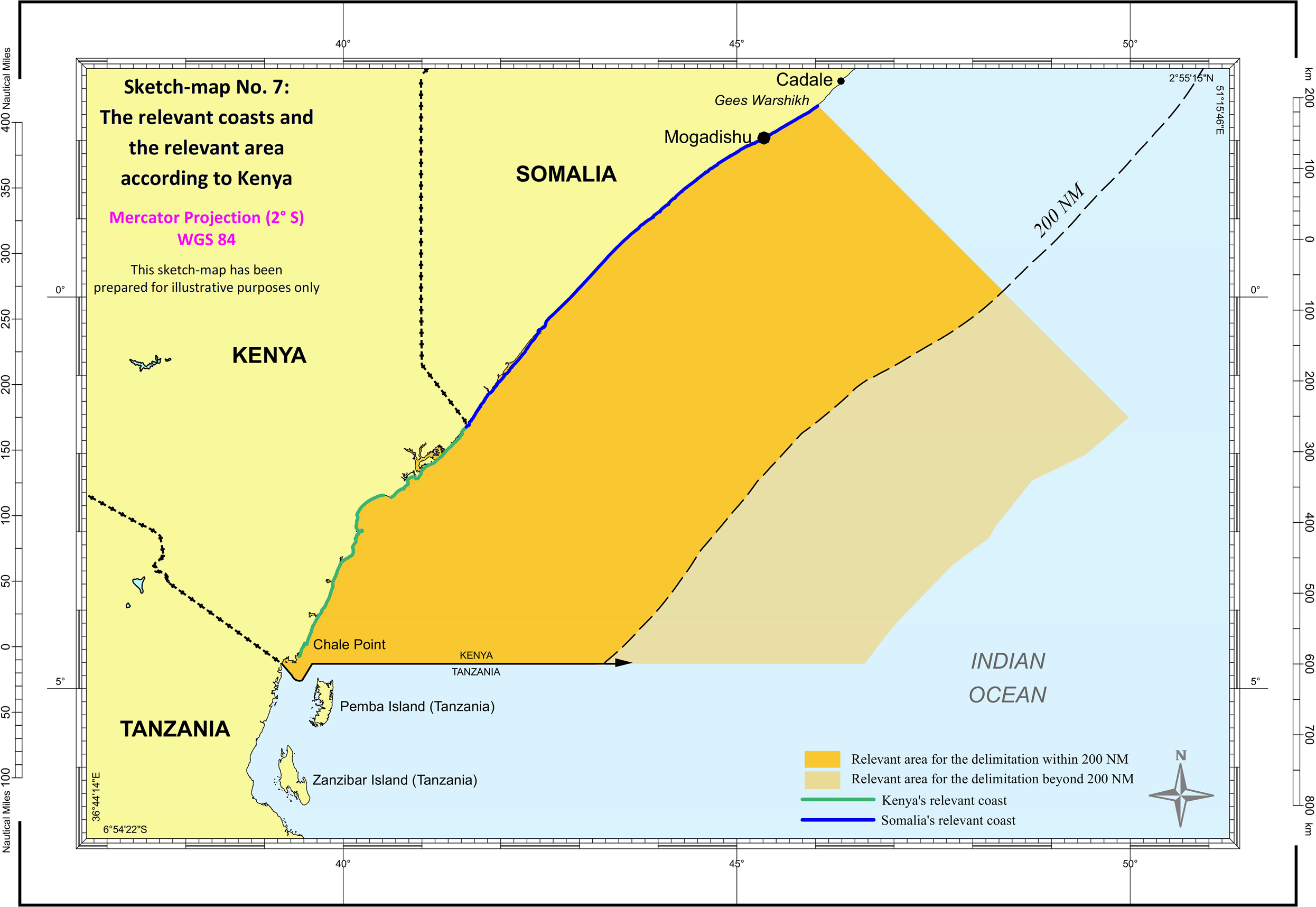
137. The Court, using radial projections which overlap within 200 nautical miles (see paragraph 132 above), has identified that the relevant coast of Somalia extends for approximately 733 km and that of Kenya for approximately 511 km (see sketch-map No. 8 below).
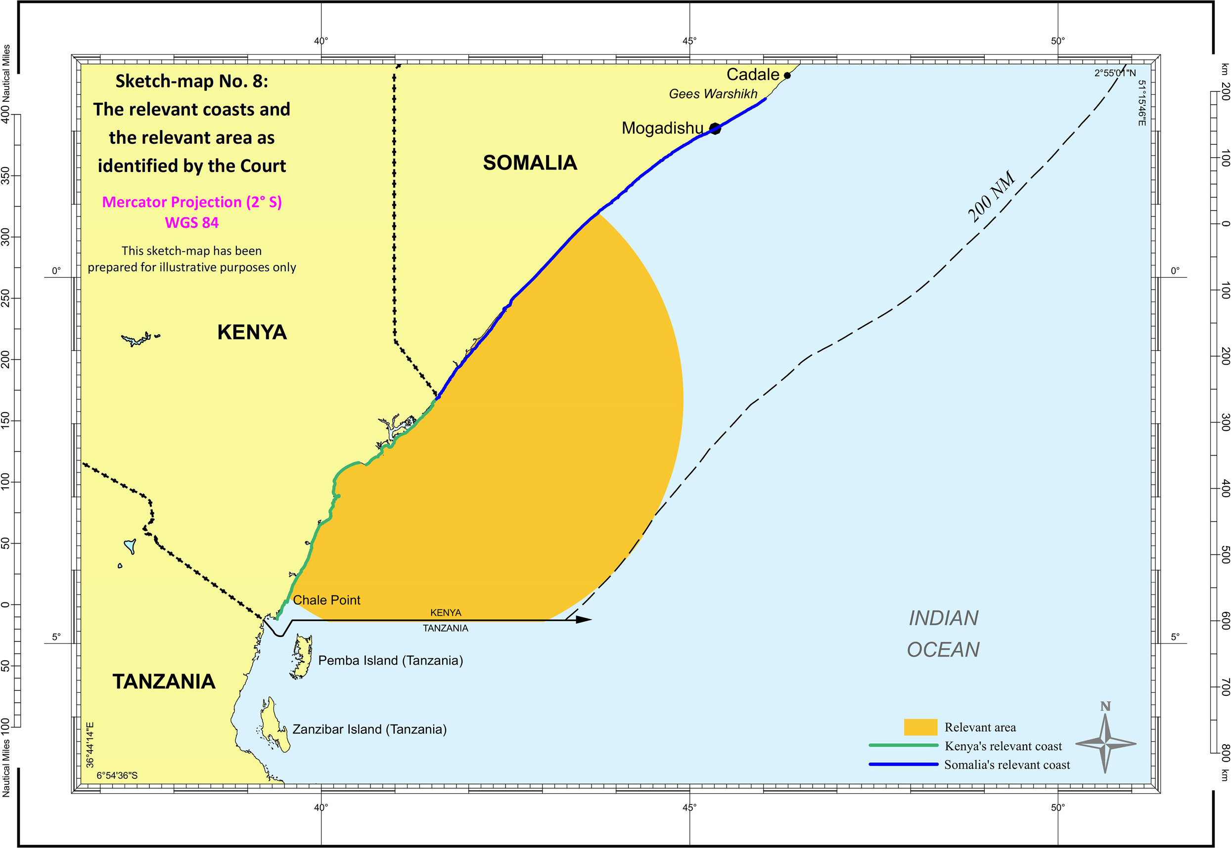
(b) Relevant area
138. The Parties disagree as to the identification of the relevant area. Somalia proceeds in two steps, first drawing 200-nautical-mile envelopes of arcs from the Parties’ baselines and identifying the area where those arcs intersect as the area of overlapping potential entitlements, excluding the area south of the agreed Kenya-Tanzania boundary. This produces a total relevant area of 213,863 sq km within 200 nautical miles. Somalia then adds to this area the maritime space beyond 200 nautical miles in which the potential entitlements of the Parties overlap. Although it accepts the role of potential entitlements for the determination of the relevant area, in fact, it limits the relevant area beyond 200 nautical miles in the north by the parallel of latitude drawn from the land boundary terminus. It appears that Somalia has done so on the basis of the claim submitted by Kenya to the CLCS. Somalia considers that this combined area constitutes the totality of the relevant area in the circumstances of the case, thus measuring approximately 319,542 sq km (see sketch-map No. 6 above).
139. Kenya rejects Somalia's approach to identifying the relevant area. According to Kenya, Somalia acts inconsistently when it applies one approach to define the relevant area within 200 nautical miles and a different approach to define the area beyond 200 nautical miles. For Kenya, the relevant area consists of the entire frontal projections of the Parties’ relevant coasts out to 350 nautical miles. In the west, the relevant area is bounded by the coasts of the Parties from Ras Wasin in the south of Kenya, through the land boundary terminus to the Somali headland of Gees Warshikh in the north. The southern limit of the relevant area is bounded by the agreed boundary between Kenya and Tanzania. In the east, the relevant area is bounded by the continental shelf limits as submitted by Somalia to the CLCS dated 21 July 2014. To define the relevant area in the north, Kenya adopts a straight line perpendicular to the coast to connect the end of the relevant coast at Gees Warshikh to the continental shelf limit. The total relevant area thus defined measures 525,300 sq km (see sketch-map No. 7 above).
140. The Court cannot accept Somalia's approach to identifying the relevant area beyond 200 nautical miles since it is not in conformity with past pronouncements of the Court on what constitutes the relevant area. The Court has explained on a number of occasions that “[t]he relevant area comprises that part of the maritime space in which the potential entitlements of the parties overlap” (see Maritime Delimitation in the Caribbean Sea and the Pacific Ocean (Costa Rica v. Nicaragua) and Land Boundary in the Northern Part of Isla Portillos (Costa Rica v. Nicaragua), Judgment, I.C.J. Reports 2018 (I), p. 184, para. 115; Territorial and Maritime Dispute (Nicaragua v. Colombia), Judgment, I.C.J. Reports 2012 (II), p. 683, para. 159). The Court also recalls its observation that “the relevant area cannot extend beyond the area in which the entitlements of both Parties overlap” (ibid., p. 685, para. 163). The fact that Kenya has limited its claim to the extended continental shelf submitted to the CLCS by the parallel of latitude does not mean that its potential entitlements cannot extend to the north of that parallel. Rather, that claim is based on Kenya's assertion that the parallel of latitude constitutes the maritime boundary between the two States, an assertion which the Court has found unproven and cannot accept.
141. The Court is of the view that, in the north, the relevant area extends as far as the overlap of the maritime projections of the coast of Kenya and the coast of Somalia. The Court considers it appropriate to use the overlap of the 200-nautical-mile radial projections from the land boundary terminus. As far as the southern limit of the relevant area is concerned, the Court notes that the Parties agree that the maritime space south of the boundary between Kenya and Tanzania is not part of the relevant area. The relevant area, as identified by the Court for the purpose of delimiting the exclusive economic zone and the continental shelf up to 200 nautical miles from the coasts, measures approximately 212,844 sq km (see sketch-map No. 8 above).
3. Provisional equidistance line
142. The Court must next construct the provisional equidistance line. To do so, it must identify the appropriate base points on the Parties’ relevant coasts which will be used for that purpose.
* *
143. Somalia suggests that the base points should be identified by using appropriate software based on the relevant nautical charts. It submits that the software automatically selects those points that generate the equidistance line, that is a line every point of which is equidistant from the nearest points on the Parties’ baselines from which the breadth of the territorial sea is measured. Having used the CARIS-LOTS software, based on US NGA Nautical Chart 61220, Somalia has identified two base points on its side of the land boundary terminus and two base points on the Kenyan side. It provides the following geographical co-ordinates for the base points on the Somali side, for base point S3 1° 39′ 14.99" S and 41° 35′ 15.68" E and for base point S4 1° 35′ 37.21" S and 41° 38′ 01.00" E. The two base points that Somalia identified on the Kenyan side have the following co-ordinates: base point K2 1° 43′ 04.77" S and 41° 32′ 37.18" E and base point K3 1° 46′ 10.97" S and 41° 30′ 45.14" E. It submits that these four base points control the entire course of the equidistance line up to 200 nautical miles from the coast.
144. Kenya contends, in Appendix 2, that Somalia failed to use the most reliable charted data. Kenya criticizes the reliance by Somalia on US NGA Nautical Chart 61220, arguing that it contains no new or independent charted data. Kenya draws the Court's attention to the fact that US NGA Nautical Chart 61220 indicates that its charted data are derived from the relevant British Admiralty or Italian charts. In Kenya's view, the appropriate chart to be used for the selection of base points is British Admiralty Chart 3362, which offers the best available charted data. Based on that chart and using the same CARIS-LOTS software, Kenya identifies the following base points for the construction of the provisional equidistance line:
Base points on Kenya's coast:

Base points on Somalia's coast:

Kenya admits that its proposed provisional equidistance line shows only slight differences from that proposed by Somalia.
145. Somalia also pointed out at the hearings that there was very little difference between the two equidistance lines constructed from the base points it had selected or from those selected by Kenya. It concluded that it would be content for the Court to use either US NGA Nautical Chart 61220 or British Admiralty Chart 3362, or any other chart that the Court might consider even more reliable.
* *
146. Taking into account the views of the Parties, the Court considers that it can rely on British Admiralty Chart 3362. It identifies the following base points as appropriate for the construction of the provisional equidistance line within 200 nautical miles of the coasts:
Base points on Somalia's coast:

Base points on Kenya's coast:

The provisional equidistance line constructed on the basis of these base points begins from the endpoint of the maritime boundary in the territorial sea (Point A) and continues until it reaches 200 nautical miles from the starting-point of the maritime boundary, at a point (Point 10′) with co-ordinates 3° 31′ 41.4" S and 44° 21′ 02.5" E (see sketch-map No. 9 below). The turning points between Point A and the 200-nautical-mile limit are the following:


4. Whether there is a need to adjust the provisional equidistance line
147. The Court will next consider whether there are factors requiring the adjustment or shifting of the provisional equidistance line in order to achieve an equitable solution. Since the cases concerning the North Sea Continental Shelf (Federal Republic of Germany/Denmark; Federal Republic of Germany/Netherlands), such factors have been referred to in the jurisprudence of the Court as relevant circumstances (Judgment, I.C.J. Reports 1969, p. 53, para. 101).
* *
148. Somalia sees no reason for adjusting the provisional equidistance line. It maintains that the relevant circumstances that may justify the adjustment of the equidistance line in order to reach an equitable solution are essentially of a geographical nature. Somalia mentions three such circumstances in particular, namely: the cut-off effect of the provisional equidistance line, appreciated within the general geographical context; the cut-off effect of such a line due to concavity of the coast; and the presence of islands in the relevant maritime area. In Somalia's view, there are no such circumstances in the present case. Nor are there any other unusual or anomalous geographical circumstances since the coasts of the Parties are comparatively straight and unremarkable. It contends that the Kenya-Tanzania maritime boundary agreement is res inter alios acta for Somalia and that it cannot have any bearing on the delimitation in the present case. It adds that the effect of that boundary agreement can only consist of depriving Kenya of some of its entitlements beyond 200 nautical miles. Somalia concludes that the provisional equidistance line should remain intact since no adjustment is required or justified.
*
149. Kenya, for its part, invokes five circumstances which, it considers, require the adjustment of the provisional equidistance line. In its view, any such adjustment should result in a boundary following the parallel of latitude. First, Kenya contends that the provisional equidistance line would lead to a severe reduction in its coastal projection constituting a significant, pronounced and unreasonable cut-off effect with respect to its maritime areas.
150. The second relevant circumstance requiring the adjustment of the provisional equidistance line is, according to Kenya, constituted by the regional practice of using parallels of latitude to define the maritime boundaries of States on the Eastern African coast.
151. Vital security interests of both the Parties and the international community at large are, in Kenya's view, another relevant circumstance that confirms the need to adjust the provisional equidistance line to the parallel of latitude. Kenya refers to the security threats of terrorism and piracy in support of its call for such an adjustment.
152. Kenya further argues that evidence of the Parties’ long-standing and consistent conduct in relation to oil concessions, naval patrols, fishing and other activities reflects the existence of a de facto maritime boundary along the parallel of latitude and that this constitutes yet another relevant circumstance that requires the adjustment of the provisional equidistance line to the parallel of latitude.
153. Finally, Kenya contends that an unadjusted equidistance line would have devastating repercussions for the livelihoods and economic well-being of Kenya's fisherfolk who are said to depend on fisheries in coastal areas near the Kenya-Somalia boundary. As Kenya sees it, their equitable access to those natural resources therefore requires the adjustment of the provisional equidistance line to the parallel of latitude. Kenya presents this as the fifth relevant circumstance to be taken into account by the Court.
* *
154. At this stage, the Court must “verify that the provisional equidistance line, drawn by the geometrical method from the determined base points on the coasts of the Parties is not, in light of the particular circumstances of the case, perceived as inequitable” (Maritime Delimitation in the Black Sea (Romania v. Ukraine), Judgment, I.C.J. Reports 2009, p. 112, para. 155). If it is, the Court should adjust the line in order to achieve an equitable solution as required by Articles 74 and 83 of the Convention.
155. As summarized above, Kenya perceives the provisional equidistance line as inequitable while Somalia does not see any plausible reason for adjusting the line and believes that it would constitute an equitable boundary.
156. The Court notes that Kenya, by invoking various factors which it considers as constituting relevant circumstances in the context of this case, has consistently sought a maritime boundary that would follow the parallel of latitude. The Court has already concluded that no maritime boundary between Somalia and Kenya following the parallel of latitude was established in the past. Nor has the Court accepted the methodology based on the parallel of latitude for establishing the maritime boundary between the Parties as advocated by Kenya. Kenya would now like to achieve the same result by a major shifting of the provisional equidistance line, changing its south-easterly direction to an exclusively easterly direction. The Court considers that such a shifting of the provisional equidistance line, as argued for by Kenya, would represent a radical adjustment while clearly not achieving an equitable solution. It would severely curtail Somalia's entitlements to the continental shelf and the exclusive economic zone generated by its coast adjacent to that of Kenya. A line thus adjusted would not allow the coasts of the Parties to produce their effects in terms of maritime entitlements in a reasonable and mutually balanced way (Territorial and Maritime Dispute (Nicaragua v. Colombia), Judgment, I.C.J. Reports 2012 (II), p. 703, para. 215; Maritime Delimitation in the Black Sea (Romania v. Ukraine), Judgment, I.C.J. Reports 2009, p. 127, para. 201).
157. The Court will begin by considering those factors, relied on by Kenya, which are non-geographical in nature.
158. As far as the security interests of Kenya are concerned, the Court is fully aware of and does not underestimate the serious threats to security in the region. These threats are certainly of legitimate concern to the States in the region and to the international community at large. The Court notes the efforts of the international community, in particular the United Nations and the African Union, as well as of various countries, including Kenya, to assist Somalia in re-establishing peace and security after many years of internal conflicts. The Court observes that boundaries between States, including maritime boundaries, are aimed at providing permanency and stability. This being so, the Court believes that the current security situation in Somalia and in the maritime spaces adjacent to its coast is not of a permanent nature. The Court is therefore of the view that the current security situation does not justify the adjustment of the provisional equidistance line. Moreover, the Court recalls its statement in a previous case that legitimate security considerations may be a relevant circumstance “if a maritime delimitation was effected particularly near to the coast of a State” (Territorial and Maritime Dispute (Nicaragua v. Colombia), Judgment, I.C.J. Reports 2012 (II), p. 706, para. 222). This is not the case here, as the provisional equidistance line does not pass near the coast of Kenya. The Court also recalls that “control over the exclusive economic zone and the continental shelf is not normally associated with security considerations and does not affect rights of navigation” (ibid.).
159. Access for Kenya's fisherfolk to natural resources is another factor which Kenya brings to the attention of the Court when arguing for the adjustment of the line. Such a factor can be taken into account by the Court as a relevant circumstance in exceptional cases, in particular if the line would “likely . . . entail catastrophic repercussions for the livelihood and economic well-being of the population of the countries concerned” (Delimitation of the Maritime Boundary in the Gulf of Maine Area (Canada/United States of America), Judgment, I.C.J. Reports 1984, p. 342, para. 237; see also Maritime Delimitation in the Area between Greenland and Jan Mayen (Denmark v. Norway), Judgment, I.C.J. Reports 1993, pp. 71–72, paras. 75–76). In the Gulf of Maine case, the Chamber of the Court did not find that the delimitation line it constructed would have such consequences. On the basis of the evidence before it, the Court is not convinced that the provisional equidistance line would entail such harsh consequences for the population of Kenya in the present case. In any event, as it appears from a map provided by Kenya, 17 out of 19 fish landing sites are located near or at the Lamu Archipelago, and would therefore be unaffected by an equidistance line. Only two landing sites are close to the land boundary terminus. Moreover, in the present case, the Court has to consider the well-being of the populations on both sides of the delimitation line. In light of the foregoing, the Court cannot accept Kenya's argument that the provisional equidistance line would deny Kenya equitable access to fisheries resources that are vital to its population.
160. The Court now turns to another argument put forward by Kenya. It contends that the evidence of the Parties’ long-standing and consistent conduct in relation to oil concessions, naval patrols, fishing and other activities reflects the existence of “a de facto maritime boundary” along the parallel of latitude which calls for the adjustment of the provisional equidistance line. In the past, summarizing its jurisprudence and that of various arbitral tribunals, the Court stated that:
“although the existence of an express or tacit agreement between the parties on the siting of their respective oil concessions may indicate a consensus on the maritime areas to which they are entitled, oil concessions and oil wells are not in themselves to be considered as relevant circumstances justifying the adjustment or shifting of the provisional equidistance line. Only if they are based on express or tacit agreement between the parties may they be taken into account.” (Land and Maritime Boundary between Cameroon and Nigeria (Cameroon v. Nigeria: Equatorial Guinea intervening), Judgment, I.C.J. Reports 2002, pp. 447–448, para. 304.)
The same is true for other types of conduct, such as naval patrols or fishing activities. The Court has already concluded that no maritime boundary along the parallel of latitude has been agreed by the Parties (see paragraphs 88 and 89 above). There is no de facto maritime boundary between Somalia and Kenya. The Court therefore cannot accept the argument of Kenya that, on the basis of the conduct of the Parties, the provisional equidistance line has to be adjusted so that it coincides with the alleged de facto maritime boundary.
161. The Court will now consider the two remaining arguments that, according to Kenya, call for the adjustment of the provisional equidistance line. Kenya submits that the application of an equidistance line would produce a significant cut-off effect with respect to its maritime areas. It also points out that the cut-off effect produced by the equidistance line is severely exacerbated past the 200-nautical-mile limit, essentially to the point that Kenya would be completely cut off from the outer limit of the continental shelf. Kenya further argues that the regional context and practice require the adjustment of the provisional equidistance line.
162. The Court and international tribunals have acknowledged that the use of an equidistance line can produce a cut-off effect, particularly where the coastline is characterized by concavity (e.g. North Sea Continental Shelf (Federal Republic of Germany/Denmark; Federal Republic of Germany/Netherlands), Judgment, I.C.J. Reports 1969, p. 17, para. 8, and p. 49, para. 89; Bay of Bengal Maritime Boundary Arbitration (Bangladesh v. India), Award of 7 July 2014, RIAA, Vol. XXXII, p. 123, para. 408). In 1985, the Court reaffirmed that an equidistance line “may yield a disproportionate result where a coast is . . . markedly concave or convex” (Continental Shelf (Libyan Arab Jamahiriya/Malta), Judgment, I.C.J. Reports 1985, p. 44, para. 56). The International Tribunal for the Law of the Sea, while stating that “in the delimitation of the exclusive economic zone and the continental shelf, concavity per se is not necessarily a relevant circumstance”, has also confirmed that
“when an equidistance line drawn between two States produces a cut-off effect on the maritime entitlement of one of those States, as a result of the concavity of the coast, then an adjustment of that line may be necessary in order to reach an equitable result” (Delimitation of the Maritime Boundary in the Bay of Bengal (Bangladesh/Myanmar), Judgment, ITLOS Reports 2012, p. 81, para. 292).
163. Somalia argues that, to the extent that there is any cut-off effect suffered by Kenya, it is solely the result of the agreed maritime boundary between Kenya and Tanzania. The Court considers that any cut-off effect as a result of the Kenya-Tanzania maritime boundary is not a relevant circumstance. The agreements between Kenya and Tanzania are res inter alios acta (Arbitration between Barbados and the Republic of Trinidad and Tobago, Award of 11 April 2006, RIAA, Vol. XXVII, p. 238, para. 346). They “cannot per se affect the maritime boundary” between Kenya and Somalia (Maritime Delimitation in the Caribbean Sea and the Pacific Ocean (Costa Rica v. Nicaragua) and Land Boundary in the Northern Part of Isla Portillos (Costa Rica v. Nicaragua), Judgment, I.C.J. Reports 2018 (I), p. 187, para. 123). However, the issue to be considered in the present case is whether the use of an equidistance line produces a cut-off effect for Kenya, not as a result of the agreed boundary between Kenya and Tanzania, but as a result of the configuration of the coastline.
164. If the examination of the coastline is limited only to the coasts of Kenya and Somalia, any concavity is not conspicuous. However, examining only the coastlines of the two States concerned to assess the extent of any cut-off effect resulting from the geographical configuration of the coastline may be an overly narrow approach. It is true that in the case concerning the Land and Maritime Boundary between Cameroon and Nigeria (Cameroon v. Nigeria: Equatorial Guinea Intervening), the Court stated that the concavity of the coastline may be a relevant circumstance for the purposes of delimitation “when such concavity lies within the area to be delimited” (Judgment, I.C.J. Reports 2002, p. 445, para. 297). However, it is worth recalling the specific context of that case, and in particular the Court's observation that “the concavity of Cameroon's coastline is apparent primarily in the sector where it faces Bioko” (ibid.), an island that is subject to the sovereignty of a third State, namely Equatorial Guinea. Prior to making this statement, the Court had concluded that “[t]he part of the Cameroon coastline . . . fac[ing] Bioko . . . cannot therefore be treated as facing Nigeria so as to be relevant to the maritime delimitation between Cameroon and Nigeria” (ibid., p. 443, para. 291). The Court's statement thus should not be understood as excluding in all circumstances the consideration of the concavity of a coastline in a broader geographical configuration.
165. Examining the concavity of the coastline in a broader geographical configuration is consistent with the approach taken by this Court and international tribunals. In the two North Sea Continental Shelf cases, the Court examined the coasts of three States, with Germany in the middle. The Court described the cut-off effect as follows:
“in the case of a concave or recessing coast . . . the effect of the use of the equidistance method is to pull the line of the boundary inwards, in the direction of the concavity . . . ‘cutting off’ the coastal State from the further areas of the continental shelf outside of and beyond this triangle” (North Sea Continental Shelf (Federal Republic of Germany/Denmark; Federal Republic of Germany/Netherlands), Judgment, I.C.J. Reports 1969, p. 17, para. 8).
The Court expressed this view in the context of proceedings that had been joined, while the cases themselves remained separate. The Court noted that “although two separate delimitations [were] in question, they involve[d] — indeed actually g[a]ve rise to — a single situation” (ibid., p. 19, para. 11). The Court emphasized that “[t]he fact that the question of either of these delimitations might have arisen and called for settlement separately in point of time, does not alter the character of the problem with which the Court is actually faced” (ibid.).
166. In both the Bangladesh/Myanmar and Bangladesh v. India cases, even though the issue was that of a boundary between the two respective States, the International Tribunal for the Law of the Sea, in the former case, and the Arbitral Tribunal, in the latter, each looked at the concavity of the coasts of the three States as a whole, with Bangladesh in the middle. In Bangladesh v. India, the Arbitral Tribunal quoted from the Judgment in the North Sea Continental Shelf cases, the Award in the Guinea/Guinea-Bissau case and the Judgment in the Bangladesh/Myanmar case to point out that when there are three adjacent States along a concave coastline, the equidistance method has the “drawback of resulting in the middle country being enclaved by the other two” (Bay of Bengal Maritime Boundary Arbitration (Bangladesh v. India), Award of 7 July 2014, RIAA, Vol. XXXII, pp. 123–124, paras. 413–416).
167. In the present case, the potential cut-off of Kenya's maritime entitlements should be assessed in a broader geographical configuration. This was also the approach adopted by the Arbitral Tribunal in the Guinea/Guinea-Bissau case. It took into consideration “the whole of West Africa” in order to seek “a solution which would take overall account of the shape of its coastline”. It noted that “[t]his would mean no longer restricting consideration to a short coastline but to a long coastline” that included the coastline of Sierra Leone (Delimitation of the Maritime Boundary between Guinea and Guinea-Bissau, Award of 14 February 1985, International Law Reports, Vol. 77, p. 683, para. 108, emphasis in the original). It expressed the view that “while the continuous coastline of the two Guineas — or of the three countries when Sierra Leone is included — is generally concave, that of West Africa in general is undoubtedly convex” (ibid.). The Tribunal observed that “[i]n order for the delimitation between the two Guineas to be suitable for equitable integration into the existing delimitations of the West African region . . . it is necessary to consider how all these delimitations fit in with the general configuration of the West African coastline” (ibid., p. 684, para. 109). The Tribunal also noted that the overall concavity of the coastline of the two States was “accentuated” if it considered “the presence of Sierra Leone further south”, with Guinea situated in the middle between Guinea-Bissau and Sierra Leone (ibid., pp. 681–682, paras. 103–104).
168. The potential cut-off of Kenya's maritime entitlements cannot be properly observed by examining the coasts of Kenya and Somalia in isolation. When the mainland coasts of Somalia, Kenya and Tanzania are observed together, as a whole, the coastline is undoubtedly concave, even more so than the coastline of Guinea-Bissau, Guinea and Sierra Leone considered together, which the Arbitral Tribunal characterized as concave (see paragraph 167 above). Kenya faces a cut-off of its maritime entitlements as the middle State located between Somalia and Tanzania. The presence of Pemba Island, a large and populated island that appertains to Tanzania, accentuates this cut-off effect because of its influence on the course of a hypothetical equidistance line between Kenya and Tanzania (see sketch-map No. 10 below).
169. The provisional equidistance line between Somalia and Kenya progressively narrows the coastal projection of Kenya, substantially reducing its maritime entitlements within 200 nautical miles. This cut-off effect occurs as a result of the configuration of the coastline extending from Somalia to Tanzania, independently of the boundary line agreed between Kenya and Tanzania, which in fact mitigates that effect in the south, in the exclusive economic zone and on the continental shelf up to 200 nautical miles.
170. The Court recalls its jurisprudence and that of international tribunals according to which an adjustment of the provisional equidistance line is warranted if the cut-off effect is “serious” or “significant” (see Maritime Delimitation in the Caribbean Sea and the Pacific Ocean (Costa Rica v. Nicaragua) and Land Boundary in the Northern Part of Isla Portillos (Costa Rica v. Nicaragua), Judgment, I.C.J. Reports 2018 (I), pp. 196–197, para. 156; Delimitation of the Maritime Boundary in the Atlantic Ocean (Ghana/Côte d’Ivoire), Judgment, ITLOS Reports 2017, p. 120, para. 425; Bay of Bengal Maritime Boundary Arbitration (Bangladesh v. India), Award of 7 July 2014, RIAA, Vol. XXXII, p. 124, para. 417).
171. In the view of the Court, even though the cut-off effect in the present case is less pronounced than in some other cases, it is nonetheless still serious enough to warrant some adjustment to address the substantial narrowing of Kenya's potential entitlements.

172. The Court has affirmed that “the achievement of an equitable solution requires that, so far as possible, the line of delimitation should allow the coasts of the Parties to produce their effects in terms of maritime entitlements in a reasonable and mutually balanced way” (Territorial and Maritime Dispute (Nicaragua v. Colombia), Judgment, I.C.J. Reports 2012 (II), p. 703, para. 215). This is an important standard to be used in making an adjustment to the provisional equidistance line. The Court, however, bears in mind the following principles: “there is . . . no question of refashioning geography, or compensating for the inequalities of nature”, “equity does not necessarily imply equality” and “there can be no question of distributive justice” (Continental Shelf (Libyan Arab Jamahiriya/Malta), Judgment, I.C.J. Reports 1985, pp. 39–40, para. 46). In other words, an adjustment should not produce an unreasonable result for Somalia.
173. The adjustment of a provisional equidistance line must be assessed on a case-by-case basis. As the Arbitral Tribunal observed in the Arbitration between Barbados and the Republic of Trinidad and Tobago, “[t]here are no magic formulas” to be used for the adjustment of a provisional equidistance line (Award of 11 April 2006, RIAA, Vol. XXVII, p. 243, para. 373). Rather, it is a result of an overall appreciation of the relevant circumstances by the Court in seeking to achieve an equitable solution. In order to attenuate the cut-off effect described above, the Court considers it reasonable to adjust the provisional equidistance line.
174. In view of the above considerations, the Court believes that it is necessary to shift the line to the north so that, from Point A, it follows a geodetic line with an initial azimuth of 114º. This line would attenuate in a reasonable and mutually balanced way the cut-off effect produced by the unadjusted equidistance line due to the geographical configuration of the coasts of Somalia, Kenya and Tanzania. The resulting line would end at its intersection with the 200-nautical-mile limit from the coast of Kenya, at a point (Point B) with co-ordinates 3° 4′ 21.3" S and 44° 35′ 30.7" E (see sketch-map No. 11 below).
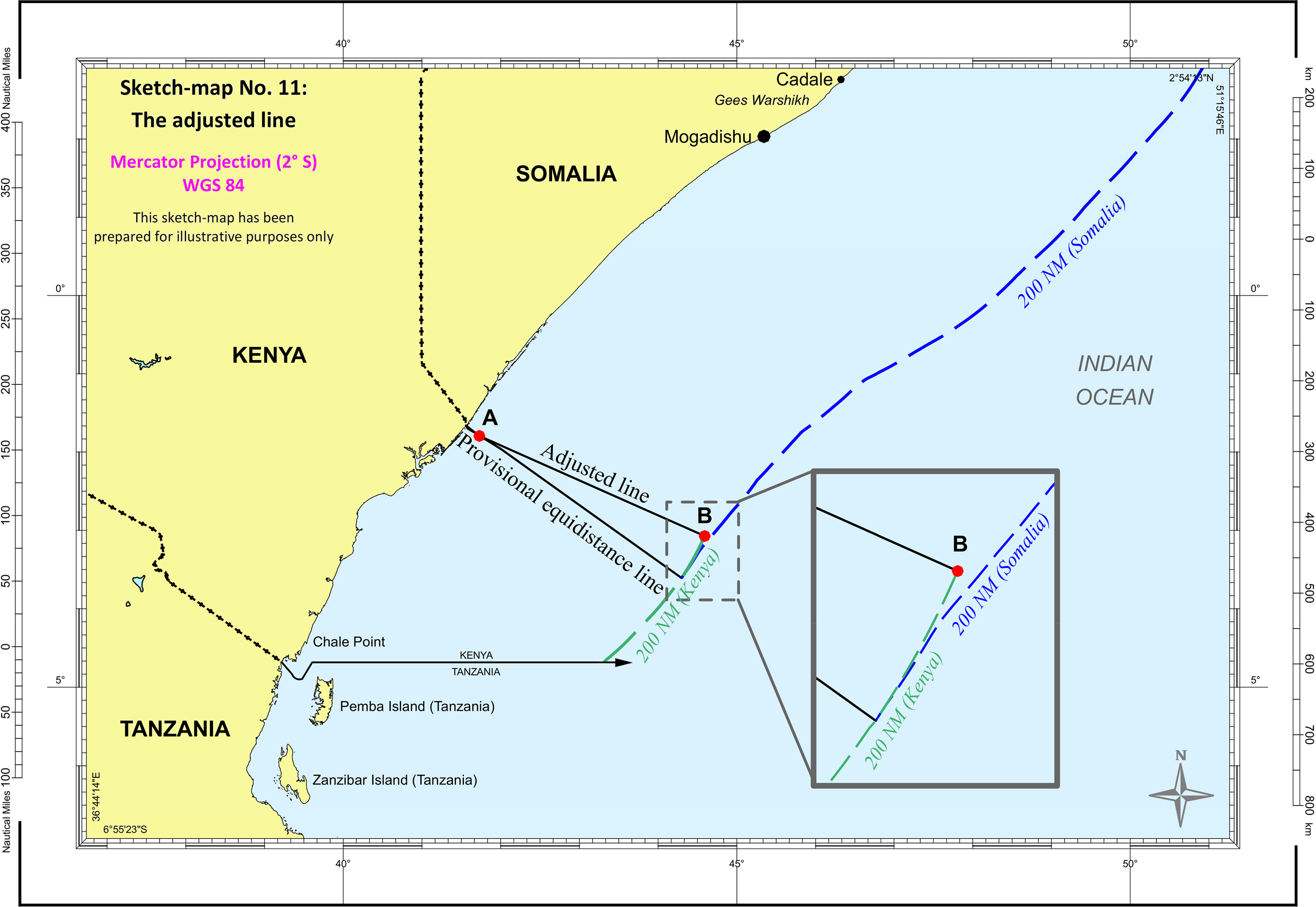
5. Disproportionality test
175. In the final stage, the Court will check whether the envisaged delimitation line leads to a significant disproportionality between the ratio of the lengths of the Parties’ respective relevant coasts and the ratio of the size of the relevant areas apportioned by that line.
176. The relevant coast of Somalia is 733 km long and that of Kenya 511 km long (see paragraph 137 above). The ratio of the relevant coasts is 1:1.43 in favour of Somalia. The maritime boundary determined by the Court divides the relevant area within 200 nautical miles of the coast in such a way that approximately 120,455 sq km would appertain to Kenya and the remaining part measuring approximately 92,389 sq km would appertain to Somalia. The ratio between the maritime zones that would appertain respectively to Kenya and Somalia is 1:1.30 in favour of Kenya. A comparison of these two ratios does not reveal any significant or marked disproportionality.
177. The Court is thus satisfied that the adjusted line that it has established as the maritime boundary for the exclusive economic zones and the continental shelves of Somalia and Kenya within 200 nautical miles in the Indian Ocean, described in paragraph 174 above, achieves an equitable solution as required by Article 74, paragraph 1, and Article 83, paragraph 1, of the Convention.
E. Question of the delimitation of the continental shelf beyond 200 nautical miles
178. The Court finally turns to the question of the delimitation of the continental shelf beyond 200 nautical miles. It is recalled that both Parties have asked the Court to determine the complete course of the maritime boundary between them, including the continental shelf beyond 200 nautical miles (see paragraphs 26 and 27 above).
* *
179. Somalia states that the Court has jurisdiction to delimit this maritime area. In this respect, Somalia argues that there is a clear distinction in the Convention between the Court's task, which consists of the delimitation of the continental shelf between the Parties under Article 83 of the Convention, and the role of the Commission on the Limits of the Continental Shelf, which is to make recommendations to coastal States on matters related to the establishment of the outer limits of their continental shelf under Article 76 of the Convention. Somalia stresses that both Kenya and Somalia have made full submissions to the Commission concerning the extent of their respective continental shelves beyond 200 nautical miles, and therefore that they have fulfilled their obligations under Article 76, paragraph 8, of the Convention. Somalia acknowledges that in its Judgment of 19 November 2012 (Territorial and Maritime Dispute (Nicaragua v. Colombia), Judgment, I.C.J. Reports 2012 (II), p. 669, para. 129), the Court declined to exercise its jurisdiction over Nicaragua's claim for the delimitation of the extended continental shelf. However, Somalia contends that this was not because the Court considered that the making of a recommendation by the Commission had any priority over delimitation. Rather, in Somalia's view, the Court considered that, in the absence of a full submission to the Commission, Nicaragua had not established that it had an entitlement to a continental shelf beyond 200 nautical miles that overlapped with Colombia's entitlement.
180. Somalia further maintains that the Court's jurisdiction with respect to the delimitation of the continental shelf beyond 200 nautical miles is not affected by the absence of the delineation of the outer limits of the Parties’ respective entitlements on the basis of the Commission's recommendations.
181. Somalia asserts that the Court has all the necessary information before it to carry out the delimitation in this maritime area, since the Parties have discharged the procedural obligation imposed upon them under Article 76, paragraph 8, of the Convention to provide the Commission with information on the limits of their continental shelves beyond 200 nautical miles. It adds that the “Parties’ entitlements to a continental shelf beyond 200 [nautical miles are] not in dispute between them”. It cites the Judgment of 14 March 2012 rendered by the International Tribunal for the Law of the Sea in the Delimitation of the Maritime Boundary in the Bay of Bengal (Bangladesh/Myanmar), where the Tribunal was satisfied with the information contained in the parties’ submissions to the Commission (Judgment, ITLOS Reports 2012, p. 116, paras. 448–449). Thus, in Somalia's view, there is no legal or practical impediment to the Court's determination of the course of the Parties’ maritime boundary while the Commission is engaged in the task of considering each Party's submission and making its recommendations for the purpose of delineating the outer limit of each Party's continental shelf.
182. Somalia argues that the legal principles applicable to delimitation of the continental shelf beyond 200 nautical miles are the same as those applicable to delimitation within 200 nautical miles. Somalia maintains that there is no relevant circumstance which could justify an adjustment of the provisional equidistance line beyond 200 nautical miles.
183. Any reduction in Kenya's overall maritime entitlements beyond 200 nautical miles, Somalia submits, “could only arise as a result of Kenya's bilateral agreement with Tanzania, by which Kenya voluntarily divested itself of a very large maritime area south of the negotiated parallel boundary”. As Somalia sees it, Kenya “voluntarily shortened its own extended continental shelf entitlement by agreement with Tanzania”. Somalia further relies on the Award in the Arbitration between Barbados and the Republic of Trinidad and Tobago (Award of 11 April 2006, RIAA, Vol. XXVII, p. 238, para. 346) for the proposition that, as a third party in relation to the agreement concluded between Kenya and Tanzania, it cannot be required to “compensate” for Kenya's choice. Therefore, Somalia requests the Court to refrain from making any adjustment of the provisional equidistance line beyond 200 nautical miles.
*
184. In keeping with its view that Somalia has acquiesced in a maritime boundary following the parallel of latitude, Kenya contends that that boundary extends on this same course beyond 200 nautical miles to the outer limits of the continental shelf, as indicated in its 2009 Submission to the CLCS. The Court has already held (paragraph 89 above) that there is no agreed maritime boundary between the Parties at the parallel of latitude through acquiescence.
185. Kenya states that, if the Court were to reject its claim regarding Somalia's acquiescence to a maritime boundary along the parallel of latitude and apply the three-stage methodology, then several relevant circumstances would call for an adjustment of the provisional equidistance line in order to achieve an equitable solution (see paragraphs 149–153 above). Kenya argues that it would suffer from a very significant cut-off effect beyond 200 nautical miles if Somalia's claimed equidistance line were adopted as the maritime boundary. Such a line, Kenya contends, would cut it off from 98 per cent of its potential entitlement to the continental shelf beyond 200 nautical miles and deprive it entirely of any entitlement to the outer limits of the continental shelf at 350 nautical miles from the Kenyan coast. It adds that the situation would be as if the outer continental shelf in this area were generated by the coastal projections of Somalia and Tanzania alone, and Kenya simply did not exist. That cut-off effect has also been invoked by Kenya as a relevant circumstance requiring the adjustment of the provisional equidistance line in the exclusive economic zone and on the continental shelf within 200 nautical miles. Kenya does not ask the Court to treat the maritime boundary agreements between Kenya and Tanzania, and between Tanzania and Mozambique, as opposable to Somalia. Rather, these agreements establish the “regional context” within which the boundary between the Parties must be appraised. According to Kenya, there is no question of being “compensated” for the agreements it has entered into, as Somalia claims. It insists that an equitable maritime delimitation cannot ignore equitable delimitations that were agreed in the past, consistent with the applicable law at the time: this is a matter both of “historical equity” and “common sense”.
* *
186. The Court held in the 2017 Judgment that it has jurisdiction over the Application filed by Somalia on 28 August 2014 and that the Application is admissible (I.C.J. Reports 2017, p. 53, para. 145(3)). In that Application, Somalia requested the Court to determine the course of the maritime boundary between the Parties in the Indian Ocean, including on the continental shelf beyond 200 nautical miles (ibid., p. 10, para. 11; see also paragraphs 25–27 above).
187. The Court recalls that, as expounded in the case concerning Territorial and Maritime Dispute between Nicaragua and Honduras in the Caribbean Sea (Nicaragua v. Honduras), “any claim of continental shelf rights beyond 200 miles [by a State party to UNCLOS] must be in accordance with Article 76 of UNCLOS and reviewed by the Commission on the Limits of the Continental Shelf established thereunder” (Judgment, I.C.J. Reports 2007 (II), p. 759, para. 319).
188. The Court observes that both States have made submissions on the limits of the continental shelf beyond 200 nautical miles to the Commission in accordance with Article 76, paragraph 8, of the Convention. Kenya made its submission to the Commission on 6 May 2009, while Somalia made its own submission on 21 July 2014 and provided an amended Executive Summary on 16 July 2015. In addition, each Party filed an objection to consideration by the Commission of the other's submission. These objections were subsequently withdrawn. The Court notes that both Somalia and Kenya have fulfilled their obligations under Article 76 of the Convention. At the same time, the Commission has yet to consider these submissions and make any recommendations to Somalia and to Kenya on matters related to the establishment of the outer limits of their continental shelves. It is only after such recommendations are made that Somalia and Kenya can establish final and binding outer limits of their continental shelves, in accordance with Article 76, paragraph 8, of UNCLOS.
189. The Court emphasizes that the lack of delineation of the outer limit of the continental shelf is not, in and of itself, an impediment to its delimitation between two States with adjacent coasts, as is the case here. As the International Tribunal for the Law of the Sea observed,
“the exercise by international courts and tribunals of their jurisdiction regarding the delimitation of maritime boundaries, including that of the continental shelf, is without prejudice to the exercise by the Commission of its functions on matters related to the delineation of the outer limits of the continental shelf” (Delimitation of the Maritime Boundary in the Bay of Bengal (Bangladesh/Myanmar), Judgment, ITLOS Reports 2012, p. 100, para. 379).
190. To support the argument that the Court may proceed to the delimitation of the continental shelf beyond 200 nautical miles on the basis of the information contained in the Parties’ submissions to the Commission, Somalia avails itself, in particular, of the Judgment in the Bangladesh/Myanmar case. It is true that in that Judgment, the Tribunal proceeded to determine the maritime boundary of the continental shelf beyond 200 nautical miles on the basis of the submissions made by Bangladesh and Myanmar to the Commission. The Tribunal was convinced that, in view of the uncontested scientific evidence on the unique nature of the Bay of Bengal and information submitted to it during the proceedings, there was a continuous and substantial layer of sedimentary rocks extending from Myanmar's coast to the area beyond 200 nautical miles. It noted that a “thick layer of sedimentary rocks covers practically the entire floor of the Bay of Bengal” (Judgment, ITLOS Reports 2012, p. 115, para. 445). It thus concluded that both Parties had entitlements to a continental shelf extending beyond 200 nautical miles (ibid., pp. 115–116, paras. 446 and 449). This being so, the Court notes that, in reaching that conclusion, the Tribunal in that case took particular account of the “unique situation [in the Bay of Bengal], as acknowledged in the course of negotiations at the Third United Nations Conference on the Law of the Sea” (ibid., p. 115, para. 444).
191. The Court observes that the entitlements of the Parties to the continental shelf beyond 200 nautical miles are to be determined by reference to the outer edge of the continental margin, to be ascertained in accordance with Article 76, paragraphs 4 and 5, of UNCLOS (ibid., p. 114, para. 437).
192. Paragraphs 4 and 5 of Article 76 provide:
“4.
(a) For the purposes of this Convention, the coastal State shall establish the outer edge of the continental margin wherever the margin extends beyond 200 nautical miles from the baselines from which the breadth of the territorial sea is measured, by either:
(i) a line delineated in accordance with paragraph 7 by reference to the outermost fixed points at each of which the thickness of sedimentary rocks is at least 1 per cent of the shortest distance from such point to the foot of the continental slope; or
(ii) a line delineated in accordance with paragraph 7 by reference to fixed points not more than 60 nautical miles from the foot of the continental slope.
(b) In the absence of evidence to the contrary, the foot of the continental slope shall be determined as the point of maximum change in the gradient at its base.
5. The fixed points comprising the line of the outer limits of the continental shelf on the sea-bed, drawn in accordance with paragraph 4 (a) (i) and (ii), either shall not exceed 350 nautical miles from the baselines from which the breadth of the territorial sea is measured or shall not exceed 100 nautical miles from the 2,500 metre isobath, which is a line connecting the depth of 2,500 metres.”
193. The entitlement of a State to the continental shelf beyond 200 nautical miles thus depends on geological and geomorphological criteria, subject to the constraints set out in Article 76, paragraph 5. An essential step in any delimitation is to determine whether there are entitlements, and whether they overlap. The situation in the present case is not the same as that addressed by the International Tribunal for the Law of the Sea in the Bangladesh/Myanmar case. In that case, the unique situation in the Bay of Bengal and the negotiation record at the Third United Nations Conference on the Law of the Sea, which threw a particular light upon the parties’ contentions on the subject, were sufficient to enable the Tribunal to proceed with the delimitation of the area beyond 200 nautical miles.
194. The Court notes that in their submissions to the Commission both Somalia and Kenya claim on the basis of scientific evidence a continental shelf beyond 200 nautical miles, and that their claims overlap. In most of the area of overlapping claims beyond 200 nautical miles, both Parties claim that their continental shelf extends to a maximum distance of 350 nautical miles. The Court further notes that neither Party questions the existence of the other Party's entitlement to a continental shelf beyond 200 nautical miles or the extent of that claim. Their dispute concerns the boundary delimiting that shelf between them. Both Parties in their submissions — Somalia in those presented at the close of the hearings and Kenya in its Rejoinder — request the Court to delimit the maritime boundary between them in the Indian Ocean up to the outer limit of the continental shelf. For the reasons set out above, the Court will proceed to do so.
195. As regards the relevant circumstances invoked by Kenya for the adjustment of the provisional equidistance line, the Court has already considered them earlier and adjusted the line accordingly in the exclusive economic zone and on the continental shelf up to 200 nautical miles. The Court recalls that both Somalia and Kenya have claimed a continental shelf extending up to 350 nautical miles in the greater part of the area of overlapping claims. Somalia has claimed a continental shelf beyond 200 nautical miles, including in the area between the point OL1, located at the end of the equidistance line it claims as the maritime boundary, at co-ordinates 5° 00′ 25.69" S and 46° 22′ 33.34" E, and point OL7, located further north, close to the parallel of latitude, at co-ordinates 2° 00′ 47.69" S and 49° 26′ 05.09" E. Kenya has claimed a continental shelf up to 350 nautical miles in the area between the point ECS1, located on the hypothetical line constructed as an extension of the existing boundary with Tanzania at co-ordinates 4° 41′ 00.29" S and 46° 34′ 36.02" E, and the point ECS38, located further north at a short distance from the parallel of latitude, at co-ordinates 1° 44′ 21.82" S and 47° 24′ 13.79" E. In view of the foregoing, the Court considers it appropriate to extend the geodetic line used for the delimitation of the exclusive economic zone and the continental shelf within 200 nautical miles to delimit the continental shelf beyond 200 nautical miles.
196. The Court therefore concludes that the maritime boundary beyond 200 nautical miles continues along the same geodetic line as the adjusted line within 200 nautical miles until it reaches the outer limits of the Parties’ continental shelves which are to be delineated by Somalia and Kenya, respectively, on the basis of the recommendations to be made by the Commission or until it reaches the area where the rights of third States may be affected. The direction of that line is depicted on sketch-map No. 12 below.
*
197. Depending on the extent of Kenya's entitlement to a continental shelf beyond 200 nautical miles as it may be established in the future on the basis of the Commission's recommendation, the delimitation line might give rise to an area of limited size located beyond 200 nautical miles from the coast of Kenya and within 200 nautical miles from the coast of Somalia, but on the Kenyan side of the delimitation line (“grey area”). This possible grey area is depicted on sketch-map No. 13. Since the existence of this “grey area” is only a possibility, the Court does not consider it necessary, in the circumstances of the present case, to pronounce itself on the legal régime that would be applicable in that area.
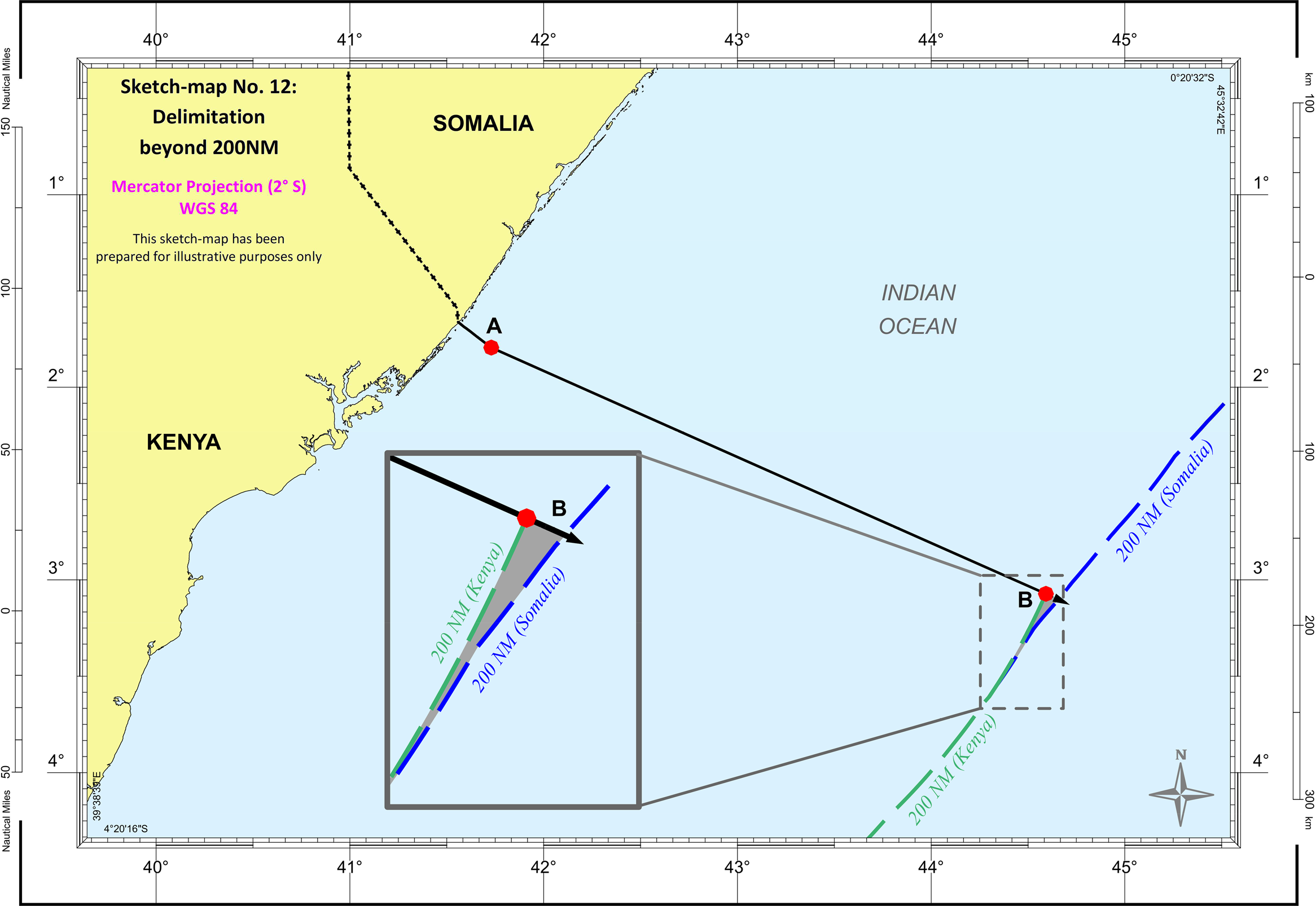

V. Alleged violations by Kenya of its international obligations
198. In its final submissions, Somalia requests the Court to “adjudge and declare that Kenya, by its conduct in the disputed area, has violated its international obligations and is responsible under international law to make full reparation to Somalia”. Somalia, however, stated during the oral proceedings that it does not insist on compensation for past violations. It asks the Court to order Kenya to cease its wrongful acts and to make available to Somalia the technical data acquired in areas that are determined by the Court to be subject to the sovereignty or sovereign rights and jurisdiction of Somalia.
199. Somalia argues that by its unilateral actions in the disputed area, Kenya has violated Somalia's sovereignty over the territorial sea and its sovereign rights and jurisdiction in the exclusive economic zone and on the continental shelf, as well as the principles enshrined in UNCLOS. Recalling Article 77 of UNCLOS, Somalia maintains that economic activities in a disputed maritime area, including exploration and exploitation, constitute a violation of the exclusive rights of the State whose jurisdiction over that area is recognized following delimitation. It adds that when it was informed of such activities and was in a position to react, it protested against them. In the Applicant's view, Kenya's argument that there was no area in dispute before 2014 is not persuasive, because an area of overlapping claims had emerged by the end of the 1970s and has remained in dispute ever since.
200. Somalia also argues that irrespective of where in the disputed area Kenya's activities took place, they were in violation of Kenya's obligation, under Article 74, paragraph 3, and Article 83, paragraph 3, of UNCLOS, not to jeopardize or hamper the reaching of a final agreement concerning the delimitation of the exclusive economic zone and continental shelf. In Somalia's view, violations of these provisions arise not only from unilateral activities that physically affect the marine environment, but, in some cases, from non-invasive acts as well, such as seismic surveys, which States can consider as a violation of their sovereign rights. The Applicant asserts that Kenya's unilateral activities in the disputed maritime area “have generated mistrust and animosity in relations between the Parties”, jeopardizing and hampering the possibility of reaching a final agreement between them.
*
201. Kenya argues that there was no dispute over the maritime boundary until 2014, when Somalia formally asserted an equidistance line. Thus, it maintains that it had the right to engage freely in activities consistent with its sovereign rights in areas where it had claimed and exercised uncontested jurisdiction. In its view, such activities cannot be said to be unlawful, even if the areas concerned had been in dispute and are now attributed by the Court to Somalia. The Respondent adds that Somalia wrongly conflates the sovereignty that coastal States enjoy in the territorial sea with the more limited sovereign rights exercised in the exclusive economic zone and on the continental shelf.
202. As regards Article 74, paragraph 3, and Article 83, paragraph 3, of UNCLOS, Kenya argues that the obligation, during the transitional period, not to jeopardize or hamper the reaching of a final agreement, does not preclude all activities in the disputed area. Kenya maintains that this obligation is concerned only with activities that lead to permanent physical change in the disputed area, and that it does not apply to activities commenced prior to a dispute. The Respondent contends that the expansive interpretation of this obligation proposed by Somalia is contrary to the jurisprudence of the Court and that of international tribunals. Kenya adds that Somalia has not provided evidence that either its Government or its population ever perceived Kenya's alleged activities as an attempt to deprive Somalia of its rights under international law. Kenya points out that most of the activities referred to by Somalia predate the emergence of the dispute in 2014 and that they were transitory in nature. Thus, it argues that Somalia has failed to establish that Kenya authorized any unlawful activities in the disputed area.
* *
203. The Court will first examine the Applicant's argument that, by its unilateral actions in the disputed area, Kenya has violated Somalia's sovereignty over the territorial sea and its sovereign rights and jurisdiction in the exclusive economic zone and on the continental shelf. The Court recalls that Somalia's submission “is made in the context of proceedings regarding a maritime boundary which had not been settled prior to the decision of the Court. The consequence of the Court's Judgment is that the maritime boundary . . . has now been delimited as between the Parties” (Territorial and Maritime Dispute (Nicaragua v. Colombia), Judgment, I.C.J. Reports 2012 (II), p. 718, para. 250). The Court considers that when maritime claims of States overlap, maritime activities undertaken by a State in an area which is subsequently attributed to another State by a judgment “cannot be considered to be in violation of the sovereign rights of the latter if those activities were carried out before the judgment was delivered and if the area concerned was the subject of claims made in good faith by both States” (Delimitation of the Maritime Boundary in the Atlantic Ocean (Ghana/Côte d’Ivoire), Judgment, ITLOS Reports 2017, p. 159, para. 592).
204. Somalia complains of surveying and drilling activities conducted or authorized by Kenya in the Lamu Basin, referring in particular to the offshore oil concession blocks identified by Kenya as Blocks L-5, L-13, L-21, L-22, L-23, L-24 and L-26. The Court notes that these concession blocks are located entirely or partially north of the equidistance line claimed by Somalia as the maritime boundary. There is no evidence that Kenya's claims over the area concerned were not made in good faith. Under the circumstances, the Court concludes that it has not been established that Kenya's maritime activities, including those that may have been conducted in parts of the disputed area that have now been attributed to Somalia, were in violation of Somalia's sovereignty or its sovereign rights and jurisdiction.
205. The Court now turns to the Applicant's argument that Kenya's activities were in violation of Article 74, paragraph 3, and Article 83, paragraph 3, of UNCLOS. These paragraphs, which refer to the exclusive economic zone and the continental shelf respectively, read as follows:
“Pending agreement as provided for in paragraph 1, the States concerned, in a spirit of understanding and co-operation, shall make every effort to enter into provisional arrangements of a practical nature and, during this transitional period, not to jeopardize or hamper the reaching of the final agreement. Such arrangements shall be without prejudice to the final delimitation.”
206. Under these provisions, States with opposite or adjacent coasts that have not reached an agreement on the delimitation of the exclusive economic zone or continental shelf are under an obligation to “make every effort . . . during this transitional period, not to jeopardize or hamper the reaching of the final agreement”. The Court considers that the “transitional period” mentioned in these provisions refers to “the period after the maritime delimitation dispute has been established until a final delimitation by agreement or adjudication has been achieved” (Delimitation of the Maritime Boundary in the Atlantic Ocean (Ghana/Côte d’Ivoire), Judgment, ITLOS Reports 2017, p. 168, para. 630). As previously noted (see paragraph 83 above), the Court is of the view that a maritime delimitation dispute between the Parties has been established since 2009. Accordingly, the Court will only examine whether the activities conducted by Kenya after 2009 jeopardized or hampered the reaching of a final agreement on the delimitation of the maritime boundary.
207. The Court observes that Somalia complains of certain activities, including the award of oil concession blocks to private operators and the performance of seismic and other surveys in those blocks, which are of a “transitory character” (see Aegean Sea Continental Shelf (Greece v. Turkey), Interim Protection, Order of 11 September 1976, I.C.J. Reports 1976, p. 10, para. 30). These activities are not of the kind that could lead to permanent physical change in the marine environment, and it has not been established that they had the effect of jeopardizing or hampering the reaching of a final agreement on the delimitation of the maritime boundary (see Arbitration regarding the Delimitation of the Maritime Boundary between Guyana and Suriname, Award of 17 September 2007, RIAA, Vol. XXX, pp. 132–133, paras. 466–467 and 470).
208. Somalia also complains of certain drilling activities, which are of the kind that could lead to permanent physical change in the marine environment. Such activities may alter the status quo between the parties to a maritime dispute and could jeopardize or hamper the reaching of a final agreement (see ibid., p. 137, para. 480). Somalia refers, in particular, to four wells drilled in the offshore Lamu Basin as of 2011, to “sea core” and “seabed core” drilling operations carried out in Block L-22 in 2013 and 2014, and to exploratory drilling in Block L-5 which was “scheduled in 2015”. Kenya does not deny having authorized drilling operations in the Lamu Basin, but states that “there was no drilling of seabed core” in Block L-22 in 2014 and that the drilling scheduled in Block L-5 “never took place”.
209. The Court notes that a presentation made in 2011 by a commissioner from Kenya's Ministry of Energy refers to offshore drilling operations in the Lamu Basin but only lists wells drilled until 2007. A map included in the Final Report of the Strategic Environmental and Social Assessment of the Petroleum Sector in Kenya, issued in December 2016 by the Ministry of Energy and Petroleum of Kenya, identifies four wells drilled in the Lamu Basin after 2009, but all of them are located south of and at a great distance from the equidistance line claimed by Somalia as the maritime boundary. The map does not show any wells drilled after 2009 in the oil concession blocks referred to by Somalia. With respect to the alleged drilling in Block L-22, two documents issued by a private operator state that “sea core drilling operations [were] in progress on the L22 offshore license” in 2013 and that “[o]n the offshore L22 license, seabed core drilling operations were carried out in early 2014”. However, these documents do not specify the precise location of those operations. As for the alleged drilling in Block L-5, Somalia has not provided the Court with evidence demonstrating that any such drilling operation ever took place. Thus, on the basis of the evidence before it, the Court is not in a position to determine with sufficient certainty that drilling operations that could have led to permanent physical change in the disputed area took place after 2009.
210. The Court further notes that, in 2014, the Parties engaged in negotiations on maritime delimitation (see paragraph 69 above) and that, in 2016, Kenya suspended its activities in the disputed area and offered to enter into provisional arrangements with Somalia.
211. In light of these circumstances, the Court cannot conclude that the activities carried out by Kenya in the disputed area jeopardized or hampered the reaching of a final agreement on the delimitation of the maritime boundary, in violation of Article 74, paragraph 3, or Article 83, paragraph 3, of UNCLOS.
212. For the reasons set out above, the Court finds that Kenya has not violated its international obligations through its maritime activities in the disputed area. Since Kenya's international responsibility is not engaged, the Court need not examine Somalia's request for reparation. Somalia's submission must therefore be rejected.
213. The maritime boundary between the Parties having been determined, the Court expects that each Party will fully respect the sovereignty, sovereign rights and jurisdiction of the other in accordance with international law.
*
* *
214. For these reasons,
The Court,
(1) Unanimously,
Finds that there is no agreed maritime boundary between the Federal Republic of Somalia and the Republic of Kenya that follows the parallel of latitude described in paragraph 35 above;
(2) Unanimously,
Decides that the starting-point of the single maritime boundary delimiting the respective maritime areas between the Federal Republic of Somalia and the Republic of Kenya is the intersection of the straight line extending from the final permanent boundary beacon (PB 29) at right angles to the general direction of the coast with the low-water line, at the point with co-ordinates 1° 39′ 44.0" S and 41° 33′ 34.4" E (WGS 84);
(3) Unanimously,
Decides that, from the starting-point, the maritime boundary in the territorial sea follows the median line described at paragraph 117 above until it reaches the 12-nautical-mile limit at the point with co-ordinates 1° 47′ 39.1" S and 41° 43′ 46.8" E (WGS 84) (Point A);
(4) By ten votes to four,
Decides that, from the end of the boundary in the territorial sea (Point A), the single maritime boundary delimiting the exclusive economic zone and the continental shelf up to 200 nautical miles between the Federal Republic of Somalia and the Republic of Kenya follows the geodetic line starting with azimuth 114° until it reaches the 200-nautical-mile limit measured from the baselines from which the breadth of the territorial sea of the Republic of Kenya is measured, at the point with co-ordinates 3° 4′ 21.3" S and 44° 35′ 30.7" E (WGS 84) (Point B);
IN FAVOUR: President Donoghue; Vice-President Gevorgian; Judges Tomka, Bennouna, Xue, Sebutinde, Robinson, Iwasawa, Nolte; Judge ad hoc Guillaume;
AGAINST: Judges Abraham, Yusuf, Bhandari, Salam;
(5) By nine votes to five,
Decides that, from Point B, the maritime boundary delimiting the continental shelf continues along the same geodetic line until it reaches the outer limits of the continental shelf or the area where the rights of third States may be affected;
in favour: President Donoghue; Vice-President Gevorgian; Judges Tomka, Bennouna, Xue, Sebutinde, Iwasawa, Nolte; Judge ad hoc Guillaume;
against: Judges Abraham, Yusuf, Bhandari, Robinson, Salam;
(6) Unanimously,
Rejects the claim made by the Federal Republic of Somalia in its final submission number 4.
Done in English and in French, the English text being authoritative, at the Peace Palace, The Hague, this twelfth day of October, two thousand and twenty-one, in three copies, one of which will be placed in the archives of the Court and the others transmitted to the Government of the Federal Republic of Somalia and the Government of the Republic of Kenya, respectively.
(Signed) Joan E. Donoghue,
President.
(Signed) Philippe Gautier,
Registrar.
President Donoghue appends a separate opinion to the Judgment of the Court; Judges Abraham and Yusuf append separate opinions to the Judgment of the Court; Judge XUE appends a declaration to the Judgment of the Court; Judge ROBINSON appends an individual, partly concurring and partly dissenting, opinion to the Judgment of the Court; Judge ad hoc Guillaume appends a separate opinion to the Judgment of the Court.
(Initialled) J.E.D.
(Initialled) Ph.G.
____________________________
Reasons for vote in favour of subparagraph (5) of the dispositive paragraph of the Judgment — Both Parties consider that the Court has sufficient information to delimit the outer continental shelf — However, Court has scant evidence regarding any outer continental shelf — Methodology that achieves an equitable delimitation of the 200-nautical-mile zones does not necessarily result in equitable delimitation of the outer continental shelf.
1. I have voted in favour of subparagraph (5) of the dispositive paragraph of the Judgment, pursuant to which the maritime boundary continues beyond 200 nautical miles until it reaches the outer limits of the continental shelf or the area where the rights of third States may be affected. I submit this opinion in order to indicate the reasons why I have cast this vote and why I do so with reluctance.
2. As the Court notes, both Parties have asked the Court to delimit the continental shelf beyond 200 nautical miles from the baselines from which the breadth of the territorial sea is measured (the “outer continental shelf”). Each Party has proposed that the Court do so by extending the boundary line that it proposes — an equidistance line on the part of Somalia and the parallel of latitude on the part of Kenya. The Court can reasonably assume that each Party has called upon the Court to delimit the outer continental shelf in full awareness of the fact that a maritime boundary established by the Court need not follow the course proposed by a party.
3. Each Party also has a comprehensive appreciation of the strength, and potential weaknesses, of its own submission to the Commission on the Limits of the Continental Shelf (the “CLCS” or “the Commission”). Neither Party has questioned the other Party's entitlement to outer continental shelf or the other Party's claim that, in certain parts of the area in which the Parties’ claims overlap, such entitlement extends to the 350-nautical-mile constraint set out in Article 76, paragraph 5, of the United Nations Convention on the Law of the Sea (“UNCLOS”). All indications, therefore, are that both Parties consider that the Court has sufficient information to arrive at an equitable delimitation of the outer continental shelf. It is on this basis that I have reached the conclusion that the Court should delimit the outer continental shelf in this case.
4. My hesitancy about the Court's decision to delimit the outer continental shelf in this case stems from the fact that the Court has scant evidence regarding the existence, shape, extent and continuity of any outer continental shelf that might appertain to the Parties. The Court is not well positioned to identify, even approximately, any area of overlapping entitlement and thus to arrive at an equitable delimitation of any area of overlap.
5. For avoidance of doubt, I note that my misgivings about the Court's decision to delimit the outer continental shelf are not animated by procedural concerns. The fact that the CLCS has not yet made a recommendation relating to the outer limits of the continental shelf of either State is not in itself an obstacle to equitable delimitation of the outer continental shelf.
6. This case is entirely different from other cases in which a tribunal has delimited the outer continental shelf of two States. In Delimitation of the Maritime Boundary in the Bay of Bengal (Bangladesh/Myanmar), the International Tribunal for the Law of the Sea (“ITLOS”) noted that there was “uncontested scientific evidence” that “practically the entire floor of the Bay of Bengal, including areas appertaining to [both Parties]”, was covered with a “thick layer of sedimentary rocks” (Delimitation of the Maritime Boundary in the Bay of Bengal (Bangladesh/Myanmar), Judgment, ITLOS Reports 2012, p. 115, paras. 445–446). The Annex VII Tribunal in the Bay of Bengal Maritime Boundary Arbitration between Bangladesh and India took note of the reasoning of ITLOS and of the maritime delimitation between Bangladesh and Myanmar and concluded that both Bangladesh and India had entitlements to outer continental shelf (Bay of Bengal Maritime Boundary Arbitration (Bangladesh v. India), Award of 7 July 2014, RIAA, Vol. XXXII, p. 138, paras. 457–458).
7. In Ghana/Côte d’Ivoire, the Special Chamber of ITLOS had the benefit of an affirmative CLCS recommendation in relation to Ghana. It observed that the geological situation of Côte d’Ivoire was “identical” to that of Ghana (Delimitation of the Maritime Boundary in the Atlantic Ocean (Ghana/Côte d’Ivoire), Judgment, ITLOS Reports 2017, p. 136, para. 491).
8. In the present case, the Court has no comparable evidence regarding the existence, extent, shape or continuity of any outer continental shelf appertaining to either Party. The Parties submitted to the Court the executive summaries of their submissions to the Commission (although not the submissions themselves). Submissions by States to the CLCS are unilateral assertions made with a view towards maximizing the area of continental shelf that the State can claim. It cannot be assumed that the Commission will adopt any State's submission.
9. My doubts about the Court's decision to delimit the outer continental shelf do not result from the particular course of the boundary that the Court has established. The lack of information about any area of overlapping entitlement would be of concern whether that delimitation had proceeded along the parallel of latitude, as Kenya proposed, along an equidistance line, as Somalia proposed, or along the adjusted equidistance line established in the Judgment.
10. I also offer a brief observation about the methodology that is appropriate to the delimitation of the outer continental shelf.
11. In relation to delimitation of the 200-nautical-mile zones, the key determinant of an equitable delimitation is normally the coastal configuration of the two States (represented by base points when an equidistance methodology is applied). The area of overlapping entitlement is identified on the basis of the projection in the seaward direction of each party's relevant coast, i.e. “the coast [of each Party] . . . [that] generate[s] projections which overlap with projections from the coast of the other Party” (Maritime Delimitation in the Black Sea (Romania v. Ukraine), Judgment, I.C.J. Reports 2009, pp. 97–98, para. 99). An equidistance line, constructed using base points on the parties’ coasts, provides an initial indication of an equitable apportionment of the area of overlap, to be adjusted if special and/or relevant circumstances so warrant.
12. Beyond 200 nautical miles from the coasts of two adjacent States, on the other hand, any area of overlapping entitlement is not determined by the configuration of the coasts of the two States, but rather by application of the geomorphological and geological criteria set out in Article 76 of UNCLOS. Coastal configuration only becomes relevant to a State's entitlement to outer continental shelf if it has been established (on the basis of the criteria set out in Article 76, paragraph 4, of UNCLOS) that the outer edge of a State's continental margin extends so far as to reach a distance of 350 nautical miles from the baselines from which the breadth of its territorial sea is measured, where the State's entitlement is limited by the 350-nautical-mile constraint contained in Article 76, paragraph 5, of UNCLOS.
13. In delimitation between two adjacent States, it is simple (and therefore inviting) to continue a delimitation line past the 200-nautical-mile limit, using a directional arrow. However, because the juridical basis for entitlement to outer continental shelf is entirely different from the basis for entitlement within 200 nautical miles, it cannot be presumed that a line that achieves an equitable delimitation of the 200-nautical-mile zones will also result in equitable delimitation of overlapping areas of two States’ outer continental shelf.
(Signed) Joan E. Donoghue.
________________________
1. J’adhère à la plupart des conclusions auxquelles est parvenue la Cour dans le présent arrêt.
2. Je suis d’avis que, comme la Cour le constate au paragraphe 89 de l’arrêt, la Somalie n’a pas acquiescé à la frontière maritime revendiquée par le Kenya, le long du parallèle, et qu’il n’existe pas, par suite, de frontière déjà convenue entre les Parties. En conséquence, j’ai voté en faveur du point 1 du dispositif, qui affirme l’absence d’accord tacite entre les Parties à cet égard.
3. Puisque c’est donc à la Cour qu’il appartenait de procéder elle-même à la délimitation des espaces maritimes relevant respectivement de la Somalie et du Kenya, elle s’y est employée, à mon avis correctement sur la plupart des points.
4. Je n’ai rien à objecter à la manière dont la Cour a fixé le point de départ de la frontière maritime (aux paragraphes 93 à 98). Je n’ai pas non plus de désaccord quant à la section de l’arrêt consacrée à la délimitation de la mer territoriale (paragraphes 99 à 118). J’approuve le tracé de la ligne médiane dont les coordonnées sont indiquées au paragraphe 117 et qui est représentée sur le croquis no 5. En conséquence, j’ai voté en faveur des points 2 et 3 du dispositif.
5. En ce qui concerne la délimitation de la zone économique exclusive et du plateau continental en deçà des 200 milles marins, j’approuve pleinement la Cour d’avoir appliqué la méthode dite «en trois étapes», désormais bien établie en jurisprudence, réaffirmant à cette occasion que si ladite méthode n’est pas obligatoire, elle est néanmoins de règle sauf s’il existe des facteurs spécifiques rendant son application inappropriée dans un cas déterminé — de tels facteurs n’existant pas en l’espèce.
6. Quant à la manière dont la Cour applique au cas d’espèce la méthode en trois étapes, je n’ai aucune critique à émettre en ce qui concerne la première et la troisième étapes. La construction de la ligne d’équidistance provisoire (paragraphes 142 à 146) n’encourt aucun reproche à mes yeux, et j’approuve les coordonnées de cette ligne telles qu’indiquées au paragraphe 146 et son tracé représenté sur le croquis no 9. J’admets aussi que la ligne de délimitation retenue par la Cour, après ajustement de la ligne d’équidistance provisoire, n’est pas invalidée par le test final visant à vérifier l’absence de disproportion, en ce qu’elle n’entraîne pas de «disproportion marquée» entre le rapport des longueurs des côtes pertinentes respectives des Parties et le rapport des espaces attribués à chacune d’elles dans la zone pertinente.
7. Mon désaccord porte sur la deuxième étape du processus, celle dont l’objet est de rechercher s’il existe des facteurs exigeant un ajustement de la ligne d’équidistance provisoire, et, si la réponse est affirmative, de procéder à l’ajustement approprié compte tenu des circonstances pertinentes (paragraphes 147 à 174). C’est en raison de mon désaccord sur le choix, comme frontière maritime, de la «ligne ajustée» telle qu’elle est figurée sur le croquis no 11, que j’ai dû, à regret, voter contre le point 4 du dispositif, qui décide du tracé de la frontière maritime unique en deçà des 200 milles marins, et, par voie de conséquence, contre le point 5, qui prolonge cette frontière au-delà des 200 milles marins, le long de la même ligne géodésique, pour délimiter le plateau continental.
8. Avant d’expliquer les raisons de mon désaccord, j’indiquerai brièvement que la manière dont l’arrêt traite les questions spécifiques de droit et de fait qui se rapportent à la détermination de la frontière entre les Parties sur le plateau continental au-delà des 200 milles marins n’appelle aucune objection de ma part, et que j’approuve également le rejet par la Cour (ainsi que les motifs sur lesquels ce rejet est fondé) des conclusions de la Somalie tendant à ce que la Cour déclare que la responsabilité internationale du Kenya est engagée du fait de la violation par ce dernier de certaines obligations internationales (raison pour laquelle j’ai voté en faveur du point 6 du dispositif).
9. Ainsi donc, mon seul désaccord avec l’arrêt — mais il porte sur une question substantielle — concerne l’examen par la Cour des circonstances justifiant — ou non — l’ajustement de la ligne d’équidistance provisoire, examen qui occupe les paragraphes 147 à 174 et constitue la deuxième étape de la méthode traditionnelle.
10. La Cour a estimé qu’un ajustement de la ligne d’équidistance provisoire par un déplacement de cette ligne vers le nord — donc au bénéfice du Kenya — était justifié par la concavité de l’ensemble du littoral de l’Afrique de l’Est, de la Somalie jusqu’à la Tanzanie. Du fait de cette concavité, le Kenya, situé au centre de ce littoral, serait désavantagé si une ligne d’équidistance stricte était utilisée pour établir les frontières maritimes. Plus précisément, si des lignes d’équidistance étaient retenues comme frontières maritimes entre le Kenya et la Somalie d’une part, entre le Kenya et la Tanzanie d’autre part, il en résulterait un effet d’amputation au détriment du Kenya. Le croquis no 10 est destiné à illustrer cette situation, en montrant que «[l]a ligne d’équidistance provisoire tracée entre la Somalie et le Kenya rétrécit progressivement la projection côtière de ce dernier, réduisant ainsi grandement ses droits maritimes en deçà de 200 milles marins» (paragraphe 169), et ce même si l’on ne tient pas compte de la frontière convenue par voie de traité entre le Kenya et la Tanzanie suivant le parallèle de latitude.
11. Je ne suis pas convaincu.
J’observe d’abord que la Cour, pour déceler une concavité provoquant un effet d’amputation justifiant un ajustement de la ligne d’équidistance, est obligée de s’éloigner significativement des côtes pertinentes, en adoptant une approche que l’on pourrait qualifier de «macrogéographique», c’est-à-dire en examinant la concavité du littoral «dans un contexte géographique plus large» que celui des Etats en cause (paragraphe 164). Or, dans l’affaire de la Frontière terrestre et maritime entre le Cameroun et le Nigéria (Cameroun c. Nigéria; Guinée équatoriale (intervenant)), la Cour s’est exprimée dans les termes suivants, qui sont à mes yeux on ne peut plus clairs :
«La Cour ne conteste pas que la concavité des côtes puisse constituer une circonstance pertinente pour la délimitation, ainsi qu’elle l’a estimé dans les affaires du Plateau continental de la mer du Nord ou comme l’a estimé le tribunal arbitral dans l’affaire de la Délimitation de la frontière maritime Guinée/Guinée-Bissau, que le Cameroun invoque. La Cour rappelle néanmoins qu’il ne peut en aller ainsi que lorsque cette concavité existe dans le secteur à délimiter.» (Arrêt, C.I.J. Recueil 2002, p. 445, par. 297.)
Il est difficile, dans la présente affaire, de prétendre que la concavité du littoral existe «dans le secteur à délimiter». Si l’on considère les côtes pertinentes de la Somalie et du Kenya, telles qu’elles apparaissent, par exemple, sur le croquis no 8 qui suit le paragraphe 141 de l’arrêt, elles ne font apparaître aucune concavité particulière, ce que d’ailleurs l’arrêt reconnaît.
Pour tenter de parer l’objection tirée du précédent Cameroun c. Nigéria, qu’il mentionne (quoiqu’il n’en fasse qu’une citation incomplète), l’arrêt souligne «le contexte particulier de cette affaire» (paragraphe 164), mais l’explication qu’il fournit à cet égard n’est guère convaincante.
12. J’admets qu’il est raisonnable, dans certaines affaires, de tenir compte non seulement de la configuration des côtes des deux Etats parties à l’instance, mais aussi de celle des côtes d’un Etat tiers (ou de plusieurs Etats tiers) lorsqu’il est manifeste que ces côtes peuvent avoir, par les projections qu’elles génèrent, des effets importants sur l’équité de la délimitation à opérer entre les deux Etats directement concernés. Tel est le cas lorsque trois Etats limitrophes bordent un littoral concave, le pays situé au centre, pris en étau entre les deux autres, se trouvant privé d’une grande partie de ses espaces maritimes par l’application stricte de la méthode de l’équidistance. En pareille hypothèse, même si l’affaire soumise à la décision judiciaire ou arbitrale n’oppose que deux des trois Etats en cause, il serait difficile au juge ou à l’arbitre de ne pas tenir compte de la configuration des côtes du troisième Etat. La Cour a raison, à cet égard, de citer les précédents constitués par les affaires Bangladesh/Myanmar et Bangladesh c. Inde, jugées respectivement par le Tribunal international du droit de la mer et un tribunal arbitral (paragraphe 166 de l’arrêt).
13. Mais même si l’on accepte de s’éloigner des côtes directement pertinentes pour prendre une vue générale de la région, en englobant d’un même regard l’ensemble du littoral allant de la Somalie au nord à la Tanzanie, voire au Mozambique, au sud, il saute aux yeux que la situation du Kenya, qui est plus ou moins au centre de cet ensemble, ne présente aucune analogie avec celle du Bangladesh enclavé entre l’Inde et le Myanmar au fond d’un golfe profondément incurvé, ou avec celle des côtes allemandes situées entre les côtes danoises et les côtes néerlandaises, telles que la Cour les a considérées ensemble dans l’affaire du Plateau continental de la mer du Nord.
Dans la présente affaire, aucune concavité significative n’apparaît dans la configuration des côtes somaliennes au nord du Kenya, ni dans la manière dont les côtes somaliennes et kényanes se prolongent dans une direction générale qui est à peu près la même. Ce sont les côtes de la Tanzanie, et elles seules, situées au sud, qui sont marquées par une certaine concavité.
14. Il est vrai que ce n’est pas la concavité des côtes en elle-même qui constitue le motif déterminant de l’ajustement de la ligne d’équidistance auquel procède la Cour, mais l’effet d’«amputation» qui en résulterait au détriment du Kenya. Mais la jurisprudence est claire et constante en ce sens qu’un effet d’amputation ne suffit pas par lui-même à justifier le déplacement de la ligne d’équidistance provisoire; cela se comprend aisément, dès lors que toute délimitation entre deux Etats dont les projections maritimes se chevauchent crée inévitablement un effet d’amputation au détriment de l’un d’entre eux, et le plus souvent des deux à la fois.
C’est seulement lorsque l’effet d’amputation est «grave» ou «important» qu’il y a lieu de le corriger — ou de l’atténuer — par un ajustement de la ligne d’équidistance, comme cela résulte de la jurisprudence citée à bon droit par la Cour au paragraphe 170 de l’arrêt.
15. Je doute fort que le critère de «gravité» soit satisfait en l’espèce. Le croquis no 10, qui montre ce que seraient les espaces maritimes dévolus au Kenya si ses frontières maritimes étaient fixées, au nord comme au sud, selon la méthode de l’équidistance, ne fait apparaître selon moi aucune amputation suffisamment grave pour justifier un ajustement de l’ampleur de celui que retient la Cour, qui aboutit à déplacer vers le nord la ligne d’équidistance entre la Somalie et le Kenya à proportion d’environ un tiers de la distance qui sépare cette ligne du parallèle revendiqué par le Kenya, sans fondement juridique valide, comme frontière agréée. En outre, il est flagrant que l’effet d’amputation que subit le Kenya résulte pour l’essentiel de la configuration de ses côtes rapportées à celles de la Tanzanie au sud, et en particulier de la présence de l’île tanzanienne de Pemba que mentionne la Cour au paragraphe 168 de l’arrêt. La Somalie se trouve ainsi privée d’une partie de ses droits maritimes pour une cause qui ne devrait être normalement pertinente que dans le contexte de la délimitation de la frontière maritime entre deux autres Etats.
Les circonstances de la cause ne justifiaient pas, selon moi, l’ajustement auquel la Cour a procédé, si même un quelconque déplacement de la ligne d’équidistance était justifié, et je ne peux pas donner mon adhésion à la solution qu’elle a adoptée.
(Signé) Ronny Abraham.
_______________________
Agreement with rejection of acquiescence — Also, with dismissal of application of parallel of latitude — Disagreement with certain aspects of implementation of methodology — Selection of base points for median line in territorial sea deviates from applicable law and jurisprudence of Court — Erroneous adjustment of provisional equidistance line by reference to “broader geographical configuration” — Taking account of extraneous relevant circumstances — Refashioning of geography in search of concavity and elusive cut-off — Incorrect use of the concept of “cut-off” — Flawed reasoning for delimitation within 200 nautical miles extended into delimitation of continental shelf beyond 200 nautical miles — Possible “grey area” may create new problems between Parties.
I. Introduction
1. I am in agreement with the decision of the Court to reject Kenya's claim that Somalia had acquiesced to a maritime boundary that follows the parallel of latitude described in paragraph 35 of the Judgment.
2. I also concur in the decision of the Court to deny Kenya's request to adjudge and declare that the maritime boundary between Somalia and Kenya in the Indian Ocean shall follow the parallel of latitude at 1° 39′ 43.2" S. As noted in paragraph 130 of the Judgment, “the Court does not consider that the use of the parallel of latitude is the appropriate methodology to achieve an equitable solution”.
3. Consequently, the Court has decided to apply a median line in the territorial sea as prescribed by Article 15 of the United Nations Convention on the Law of the Sea (hereinafter “UNCLOS”) and to use its usual three-stage methodology for the establishment of the maritime boundary in the exclusive economic zone (hereinafter “EEZ”) and continental shelf. However, the way in which the base points have been selected in the construction of the median line for the territorial sea departs from the provisions of UNCLOS and from the jurisprudence of the Court. I will therefore address this matter in the present opinion.
4. As indicated in my vote against subparagraphs (4) and (5) of the dispositif, my main disagreement relates to the manner in which the three-stage methodology has been implemented, particularly with regard to the adjustment of the equidistance line. I could not agree with the unprecedented search for a concavity in a so-called “broader geographical configuration” (cf. paragraphs 164–168 of the Judgment), which has nothing to do with the geography and coastlines of Somalia and Kenya, but can only be understood as an attempt to justify a “judicial refashioning of geography”.
5. This is further compounded by a substantial adjustment of the provisional equidistance line constructed for the delimitation of the EEZ and continental shelf, without any reasons given except that it has been done on the basis of an allegedly “serious cut-off” of the coastal projections of Kenya (cf. paragraphs 168 and 171 of the Judgment). However, no such “serious cut-off” can be visualized within 200 nautical miles, even on sketch-map 10 of the Judgment entitled “Geographical configuration and its effect on equidistance lines”. This is a very regrettable and unprecedented use of the words “serious cut-off” for something different from what they actually mean.
6. The use of a geodetic line based on the incorrectly adjusted equidistance line brings into the delimitation of the area beyond 200 nautical miles the same flawed reasoning used for the area within the 200-nautical-mile zone. This reasoning does not take into account the fact that any “cut-off” effect of Kenya's coastal projections in the outer continental shelf could solely be due to its agreement with Tanzania, which should have no legal effect on the delimitation between Somalia and Kenya. Moreover, the incorrect adjustment of the equidistance line gives rise to what the Judgment refers to as a “possible grey area” on the edge of the 200-nautical-mile delimitation. This “possible grey area”, which is depicted in sketch-map No. 12, may also lead in the future to a “Court-created” new problem between the Parties.
7. The reasons for my above reservations and disagreements are further elaborated below.
II. The construction of a median line in the territorial sea
8. The approach taken in the Judgment in the selection of base points for the construction of a median line is questionable for a number of reasons. First, according to Article 15 of UNCLOS, the median line in the territorial sea shall be constructed by reference to “the nearest points on the baselines from which the breadth of the territorial seas of each of the two States is measured”Footnote 1. In this regard, Article 5 of UNCLOS states that, in principle, “the normal baseline for measuring the breadth of the territorial sea is the low-water line along the coast” (emphasis added). In Qatar v. Bahrain, the Court referred to Article 5 of UNCLOS and stated that “under the applicable rules of international law the normal baseline for measuring this breadth is the low-water line along the coast”Footnote 2.
9. Similarly, in Eritrea/Yemen, the arbitral tribunal rejected Yemen's argument that it should establish the median line boundary from base points on the high-water line, noting that “the use of the low-water line is laid down by a general international rule in the Convention's article 5” and this “accords with long practice and with the well-established customary rule of the law of the sea”Footnote 3. In Bangladesh v. India, the UNCLOS Annex VII arbitral tribunal referred to Eritrea/Yemen and reaffirmed that it would “determine the appropriate base points by reference to the physical geography at the time of the delimitation and to the low-water line of the relevant coastsFootnote 4”.
10. Thus, both this Court and other international courts and tribunals have plotted a provisional equidistance or median line in the territorial sea by reference to such base points on the low-water line in accordance with Article 5 of UNCLOS and general international lawFootnote 5. It follows that, in accordance with the provisions of UNCLOS, its own jurisprudence and the practice of other courts and tribunals, the Court should have constructed a provisional median line by reference to such base points on the low-water line from which the breadth of the territorial sea is measured. However, the Judgment deviates from this practice without providing adequate reasons for its seemingly random selection of base points.
11. Secondly, it is well established that, when the parties agree on a particular point, such as the placement of base points on the coast for the purposes of maritime delimitation, the respective court or tribunal will respect that agreementFootnote 6, unless particular reasons warrant a different conclusion. In the present case, both Parties have proposed base points for the construction of the provisional median line, which reflect the geographical reality in the immediate vicinity of the land boundary terminus (hereinafter “LBT”). In its Memorial, Somalia identified three base points on the Somali side, two of which were located on the Diua Damasciaca Islands (S1 and S2), while the third (S3) was located on a low-tide elevation near the southernmost tip of Ras ChiamboniFootnote 7. On the Kenyan side, Somalia identified two base points (K1 and K2) “on the most seaward points on the charted low-tide coast” of Kenya's mainlandFootnote 8.
12. While Kenya did not originally identify any base points for the construction of the provisional median line, it provided such co-ordinates in the additional document it submitted as Appendix 2, Volume 1 (hereinafter “KAD”)Footnote 9. First, Kenya proposed two base points on the mainland in the immediate vicinity of the LBT (K1 and S1), both of which are less than 1 km away from the LBT. On the Somali side, Kenya proposed a base point (S2) on the Diua Damasciaca Islands, and another base point (S3) on the low-water line of Ras Chiamboni. On the Kenyan side, Kenya has — just like Somalia — proposed base points on the low-water line of the mainland's coastline (K3, K4 and K5)Footnote 10.
13. The base points proposed by the Parties for the construction of the provisional median line are largely concordant. Both Somalia and Kenya have placed base points on the Diua Damasciaca Islands and the low-water line of the mainland. Indeed, Kenya's S2 is some 74 metres away from Somalia's S1, and about 342 metres away from Somalia's S2. The distance between Kenya's S3 and Somalia's S3 is approximately 587 metres. Somalia's K2 is just about 775 metres away from Kenya's K3 and 230 metres away from Kenya's K4Footnote 11. As a result, the provisional median lines constructed by both Parties are very similar, as the Parties themselves have acknowledgedFootnote 12.
14. Notwithstanding the Parties’ general agreement on this point, the Judgment disregards the base points proposed by the Parties both on the mainland low-water line and the southernmost tip of Ras Chiamboni, as well as the Diua Damasciaca Islands, and departs both from the provisions of UNCLOS and from the jurisprudence of the Court regarding base points. Instead, a median line is constructed using base points which are located exclusively on the Parties’ terra firma (S1 to S4 and K1 to K4) and spread across an artificially straight line on the coast (paragraphs 115–116 of the Judgment). This is justified in the Judgment with the following statement: “Although in the identification of base points the Court will have regard to the proposals of the parties, it need not select a particular base point, even if the parties are in agreement thereon, if it does not consider that base point to be appropriate” (paragraph 111).
15. It may be true that in the Black Sea case, the Court stated that it “should not base itself solely on the choice of base points made by one of those Parties”Footnote 13. The Court, however, did not suggest that it enjoys an unlimited discretion in selecting whichever base points it likes, nor did it elevate the criterion of “appropriateness” or what the Court “consider[s] . . . to be appropriate” (see paragraphs 111–112) to an all-encompassing standard on the basis of which the identification of base points should be made. On the contrary, the Court stated that it “must . . . select base points by reference to the physical geography of the relevant coastsFootnote 14”. In the same vein, the Court stressed that
“the geometrical nature of the first stage of the delimitation exercise leads it to use as base points those which the geography of the coast identifies as a physical reality at the time of the delimitation. That geographical reality covers not only the physical elements produced by geodynamics and the movements of the sea, but also any other material factors that are present.Footnote 15”
16. Thirdly, it is difficult to understand the decision to ignore the base points proposed by the Parties on the southernmost tip of Ras Chiamboni, a protuberance on the Somali mainland near the LBT. By ignoring Ras Chiamboni, the Judgment has disregarded a material feature in Somalia's coastline which marks a “significant shift” in the direction of its coast. Even more confusingly, while paragraph 114 of the Judgment discounts Ras Chiamboni as a “minor protuberance” for the purposes of a median line, paragraph 146 of the Judgment places base point S6 on a much smaller protuberance in Somalia's coast (opposite the Umfaali islets) for the purposes of constructing a provisional equidistance line in the EEZ and continental shelf. No explanation is given in the Judgment for such an inconsistent selection of base points.
17. Fourthly, this inconsistent approach is further repeated with regard to the base points proposed by the Parties on the Diua Damasciaca Islands, which are equally set aside. According to the Judgment, these islands are “tiny [and] arid” and “would have a disproportionate impact on the course of the median line” (paragraph 114). Curiously, however, paragraph 146 of the Judgment has placed base points K5 and K6 on Shakani Island off Kenya's main coast, without giving reasons for this manifest inconsistency.
18. The fact that the Diua Damasciaca Islands are “tiny [and] arid” does not, ipso facto, preclude the Parties or the Court from selecting appropriate base points thereon as reflected in the past practice of the Court. It should indeed be recalled that the Court has considered appropriate to place base points on small insular features that were located in the immediate vicinity of the coast. This was the case, for example, in the Black Sea case, where the Court considered appropriate to use the south-eastern tip of Tsyganka Island as a base point, “because in this area of adjacency it [was] the most prominent point on the Ukrainian coast”Footnote 16. In Nicaragua v. Colombia, the Court also considered that the “islands fringing the Nicaraguan coast” formed part of the “relevant coast” of Nicaragua, and consequently placed the base points on the Edinburgh Reef, Muerto Cay, Miskitos Cays, Ned Thomas Cay, Roca Tyra, Little Corn Island and Great Corn IslandFootnote 17. Also, while the Court refrained from placing base points on sandy features that are relatively unstable, it observed in Costa Rica v. Nicaragua that it would “construct the provisional median line for delimiting the territorial sea only on the basis of points situated on the natural coast, which may include points placed on islands or rocks”Footnote 18.
19. The Judgment's approach in the selection of base points has resulted in a contrived median line, the construction of which appears to have been aimed at producing a line which comes as close as possible to a bisector line, although there is nothing that justifies the use of a bisector for the delimitation of the territorial sea between Somalia and Kenya. Paragraph 118 in the Judgment reinforces this impression. Indeed, this paragraph suggests that the approach adopted by the Court for the construction of the median line may have been dictated by the search for a median line that “corresponds closely to the course of a line ‘at right angles to the general trend of the coastline’, assuming that the 1927/1933 treaty arrangement, in using this phrase, had as an objective to draw a line that continues into the territorial sea, a question that the Court need not decide”.
20. The 1927/1933 land boundary demarcation arrangements concluded between the former colonial Powers (Great Britain and Italy) have no relevance whatsoever to the dispute between Somalia and Kenya or to the delimitation of their maritime boundaries, because no maritime boundary between them was ever established by such arrangements, nor by the land boundary agreement concluded between the two colonial Powers in 1924, on which the 1927/1933 arrangements are based. As stated by Somalia in its reply to the question posed by a Member of the Court, “[n]either [it] nor Kenya, since their independence and at all times thereafter, has ever claimed that the maritime boundary in the territorial sea follows a line perpendicular to the coast at Dar es Salam, for any distance”.
21. The reference to such arrangements in paragraph 118, and the manner in which it is phrased, can only create misunderstandings. That is particularly the case because the Judgment itself, several paragraphs earlier, discounts the relevance of such colonial land demarcation agreements to the maritime boundary, inter alia, on the basis of the positions taken by the two neighbouring States both in their national legislation and in their negotiations and statements (see paragraphs 106 to 109). It is indeed concluded at the end of these paragraphs that “the Court therefore considers it unnecessary to decide whether the 1927/1933 treaty arrangement had as an objective the delimitation of the boundary in the territorial sea” (paragraph 109). Such an objective could not manifestly exist in a land demarcation agreement. What purpose is then served by invoking the same arrangement again in paragraph 118 in connection with the course of the median line as constructed by the Court? None whatsoever, in my view, if not to cast unwarranted doubt on the validity of the positions taken, and so clearly expressed, by two independent African States in their national legislation following their independence and the consequent exercise of their right to self-determination 60 years ago.
III. Delimitation of the EEZ and continental shelf within 200 nautical miles
22. As pointed out above, I disagree with the flawed reasoning used in the Judgment to justify the adjustment of the provisional equidistance line. It is wrong both as a matter of fact and of law. As a matter of fact, it entails an arbitrary refashioning of the geography by engaging in a search for a purported “concavity” in a so-called “broader geographical configuration” beyond the area of delimitation, which appears to be aimed at achieving preconceived results. As a matter of law, the reasoning deviates not only from the Court's long-standing jurisprudence on the delimitation of the EEZ and continental shelf, but also from that of other international tribunals, without offering any rationalization for doing so. I will address each of these points in turn.
A. Refashioning of geography in search of a concavity and an elusive cut-off
23. The Court had hitherto applied its dictum that there should be no question of “a judicial refashioning of geography, which neither the law nor the practice of maritime delimitation authorizes”Footnote 19. It is unfortunate that the Judgment breaks with that tradition. It does so by engaging in a search for a concavity beyond the coasts of the Parties and an elusive cut-off effect that could justify the adjustment of the equidistance line. Thus, it is stated in paragraph 164 that “[i]f the examination of the coastline is limited only to the coasts of Kenya and Somalia, any concavity is not conspicuous”. This is quite correct, and the story should have ended there because as was stressed by the Court in Cameroon v. Nigeria, “the concavity of the coastline may be a circumstance relevant to delimitation”, but “this can only be the case when such concavity lies within the area to be delimited”Footnote 20. However, the Judgment then goes on to say: “examining only the coastlines of the two States concerned to assess the extent of any cut-off effect resulting from the geographical configuration of the coastline may be an overly narrow approach”. It is not clear why the analysis is suddenly shifted to an assessment of a cut-off effect, or what is exactly meant by “geographical configuration of the coastline” in this context. In any case, “examining only the coastlines of the two States concerned” is not a narrow approach, but is in conformity with the scope of the jurisdiction of the Court which cannot be extended to the coastlines of third States. Somalia and Kenya requested the Court to delimit their maritime boundary, not that of third States. It is also legally erroneous to look for a concavity outside of the area to be delimited or to try to import it into a geographical area where it does not exist in order to achieve preconceived results.
24. The relevant circumstances that may justify the adjustment of a provisional equidistance line are essentially of a geographical nature. Indeed, the construction or adjustment of an equidistance line is dictated by the particular geography of the area to be delimited. It must faithfully reflect that geography, and that geography only. For such circumstances to be taken into account in order to achieve an equitable solution, they must also arise within the area to be delimited. It is the geographical situation of that area, its coastal configuration, the length of the coast and the presence of any special or unusual maritime features therein that may give rise to relevant circumstances to be taken into account in the construction or adjustment of an equidistance line. The importation of extraneous geographical factors lying beyond the Parties’ relevant coasts and the relevant area plainly contradicts the cardinal principle that “the land dominates the sea”.
25. The reliance of the Judgment on a so-called “broader geographical configuration”, which is not defined anywhere and the scope of which is not clearly indicated, effectively disconnects its analysis from the reality of the geographical circumstances prevailing in the relevant coasts and the relevant area of the maritime dispute between Somalia and Kenya. Moreover, by expanding the scope of enquiry into the coastline of a third State, the Judgment has reduced into irrelevance the role and function of the central concepts of “relevant coasts” and “relevant area” in the three-step methodology developed over the years by the Court for maritime delimitation, while paying lip service to their use in the present case.
26. Both the meaning of the word “concave” and the concept of “concavity” in maritime delimitation are also misused in the Judgment. First, in order to be described as “concave”, a coastline must look indented, hollowed or recessed in the middle, and curve inward like the inside of a bowl. According to the Oxford English Dictionary, concave means “having an outline or surface that curves inward like the interior of a circle or sphere”. Is there any coastal area which curves inward or looks like the inside of a bowl or the interior of a circle in the coastline of Somalia or Kenya? The answer is negative. The Judgment itself recognizes as much in paragraph 164. However, in an attempt at judicial refashioning of geography, it continues in its relentless, yet unjustified, search of such “concavity” in what it refers to as a “broader geographical configuration”.
27. Secondly, a concavity is a geographical given. It either exists or not in the area to be delimited. For it to be acknowledged or taken into account in the context of a maritime delimitation, it must belong to the geographical reality of such an area. It cannot be grafted onto the area by importing it from a “broader geographical configuration”, whatever such an expression may mean. The only coastline on which one can find a slight concavity in East Africa is that of Tanzania; but this country is not a party to the dispute before the Court. The coastline of Tanzania has nothing to do with a maritime delimitation between Somalia and Kenya.
28. Nevertheless, it becomes eventually clear in paragraph 168 of the Judgment that it is indeed the Tanzanian coastline that is taken into account in order to justify the existence of a concavity in this part of the East African coast which the three States share. Thus, it is stated in paragraph 168: “The potential cut-off of Kenya's maritime entitlements cannot be properly observed by examining the coasts of Kenya and Somalia in isolation. When the mainland coasts of Somalia, Kenya and Tanzania are observed together, as a whole, the coastline is undoubtedly concave”. From this observation, which practically includes the Tanzanian coast into the area to be delimited, contrary to the long-standing practice of the Court, the conclusion is drawn that “Kenya faces a cut-off of its maritime entitlements as the middle State located between Somalia and Tanzania”.
29. According to this reasoning, a strict equidistance line would be suitable for the delimitation of the coasts of Kenya and Somalia alone since they show no observable concavity when taken by themselves; but when the coast of Tanzania is taken into account, such an equidistance line would create a disadvantage for Kenya. This means that the Court has to take the coastline of a third State — not party to the dispute or to this case — into account in order to justify this artificial disadvantage which Kenya would suffer if an unadjusted equidistance line were used. However, what is overlooked by this erroneous analysis is that, for a concavity and its potential cut-off effect to be taken into account as a relevant circumstance in the delimitation of maritime areas, it must be rooted in the coastline of one of the Parties. The involvement in the delimitation process of coasts other than those of the Parties will have the effect of extending the area to be delimited to a coastline which has in fact nothing to do with it.
30. As was observed by Judge Koretsky in the North Sea Continental Shelf cases, macrogeographical considerations are “entirely irrelevant” in maritime delimitation, “except in the improbable framework of a desire to redraw the political map of one or more regions of the world”Footnote 21. The arbitrary refashioning of geography to achieve preconceived results does not only distort the concept of relevant circumstances in the usual methodology of the Court for maritime delimitation in the EEZ and continental shelf, but it clearly contradicts its jurisprudence. As was correctly emphasized by the Court in Cameroon v. Nigeria: “The geographical configuration of the maritime areas that the Court is called upon to delimit is a given. It is not an element open to modification by the Court but a fact on the basis of which the Court must effect the delimitation.”Footnote 22
B. The departure from the Court's settled jurisprudence
31. I am equally in disagreement with the Judgment with regard to the adjustment of the equidistance line on the basis of the above-described considerations since, in doing so, it departs from the settled jurisprudence of the Court and of other international tribunals. In the Continental Shelf (Tunisia/Libyan Arab Jamahiriya) case, the Court observed that
“[t]he only areas which can be relevant for the determination of the claims of Libya and Tunisia to the continental shelf in front of their respective coasts are those which can be considered as lying either off the Tunisian or off the Libyan coast. These areas form together the area which is relevant to the decision of the dispute.”Footnote 23
Similarly, in Cameroon v. Nigeria, the Court noted that “the maritime boundary between Cameroon and Nigeria can only be determined by reference to points on the coastlines of these two States and not of third States”Footnote 24. In Costa Rica v. Nicaragua, Costa Rica argued that it found itself in the situation of a “three-State concavity” where the “coastal concavity and the cut-off created by that concavity in conjunction with a notional delimitation with a third State” (Panama) would lead to an inequitable resultFootnote 25. The Court rejected this argument observing that
“[t]he overall concavity of Costa Rica's coast and its relations with Panama cannot justify an adjustment of the equidistance line in its relations with Nicaragua. When constructing the maritime boundary between the Parties, the relevant issue is whether the seaward projections from Nicaragua's coast create a cut-off for the projections from Costa Rica's coast as a result of the concavity of that coast.Footnote 26” (Emphases added.)
32. However, in an attempt to justify the departure from the Court's practice, it is stated in paragraph 167 of the Judgment that “[i]n the present case, the potential cut-off of Kenya's maritime entitlements should be assessed in a broader geographical configuration. This was also the approach adopted by the Arbitral Tribunal in the Guinea/Guinea-Bissau case.” It is rather strange that the Court should rely as judicial precedent on an award which considered the equidistance methodology, generally used by the Court, inapplicable to the delimitation of the coasts of Guinea and Guinea-Bissau because of their concavityFootnote 27. More specifically, the award did not treat the concavity of the coastline of a third State in the region — since, in any event, the concavity was located within the relevant coasts of the partiesFootnote 28 — as a relevant circumstance for the adjustment of the provisional equidistance line. Rather, the tribunal adopted a methodology “looking at the whole of West Africa” as “a long coastline”, leading “towards a delimitation which [wa]s integrated into the present or future delimitations of the region as a whole”Footnote 29.
33. Moreover, as was pointed out by the ITLOS Special Chamber in Ghana/Côte d’Ivoire, “the approach taken by that Award was not followed by subsequent international jurisprudence”Footnote 30. Indeed, the Chamber was “not convinced that Côte d’Ivoire c[ould] rely on the jurisprudence of this Arbitral Award [in Guinea/Guinea-Bissau] to sustain its reasoning”, especially since “the maritime area off the coasts of Guinea and Guinea-Bissau is geographically complex, whereas the coasts of Ghana and Côte d’Ivoire are straight rather than indented”Footnote 31, which is the case also of the coasts of Somalia and Kenya. It is therefore difficult to understand why the International Court of Justice would have recourse to such an award, which flies in the face of its own jurisprudence in the delimitation of maritime boundaries through the use of the equidistance line in a three-stage methodology.
34. The other judgments and awards relied upon to justify the adjustment of the equidistance line are similarly either inapposite or have nothing to do with the circumstances of the present case, and do not provide authority for taking into account as a relevant circumstance, the coastline of a third State which is not party to these proceedings and which is situated well beyond the relevant coasts and area. First, reference is made to the North Sea Continental Shelf cases (paragraph 165). It may be true that in the North Sea Continental Shelf cases, the Court recognized that the marked concavity or convexity of the coastline may amount to an equitable consideration for the adjustment of the equidistance lineFootnote 32. But, in that case, the marked concavity and convexity of the coastline existed in the relevant coasts of all three States that were parties to the proceedings; it did not involve the coastlines of a third State far from the relevant area, such as the United Kingdom, Norway or Belgium.
35. Secondly, paragraph 166 refers to the cases of Bangladesh/Myanmar and Bangladesh v. India. Leaving aside the fact that the Bay of Bengal, with its marked concavities and sinuosities, bears no resemblance to the — almost linear — coastlines of Somalia and Kenya, in those cases the respective tribunals limited their enquiry specifically to the coasts of the parties to these proceedings. They did not consider the potential effect of the concavity of the Bay of Bengal vis-à-vis the coasts of third States. As stated by ITLOS in Bangladesh/Myanmar, “concavity per se is not necessarily a relevant circumstance”Footnote 33. The Tribunal stressed that an adjustment may be necessary “when an equidistance line drawn between two States produces a cut-off effect on the maritime entitlement of one of those States, as a result of the concavity of the coast”Footnote 34; the “coast in question”, however, was understood as “the coast of Bangladesh”, a party to these proceedings, not the coastline of India, which was not mentioned in the relevant analysisFootnote 35.
36. In Bangladesh v. India, the arbitral tribunal also referred to Cameroon v. Nigeria and Bangladesh/Myanmar, “not[ing] the common view in international jurisprudence that concavity as such does not necessarily constitute a relevant circumstance requiring the adjustment of a provisional equidistance line”Footnote 36. The tribunal stressed that “the existence of a cut-off effect should be established on an objective basis and in a transparent manner”, whereas “a decision as to the existence of a cut-off effect must take into account the whole area in which competing claims have been made”Footnote 37. In assessing the concavity as a relevant circumstance, the arbitral tribunal examined the projections of the “coast of Bangladesh”, which was “manifestly concave”, and the projections of the “south-east-facing coasts of India”Footnote 38. It did not take into account the coastlines of Myanmar, which was not mentioned in the relevant analysis.
37. Thirdly, even if it were to be assumed, arguendo, that a concavity exists in the area to be delimited, which of course is not the case here, such a concavity would have to be, in the first instance, a marked one; and secondly it would have to produce a severe or serious cut-off effect to be considered as a relevant circumstance. Neither a marked concavity in East Africa, including the Tanzanian coast, nor a serious cut-off or shut-off of the seaward projection of Kenya's maritime boundary can be identified on a map in the instant case within the 200-nautical-mile area. A strict equidistance line between Somalia and Kenya allows the seaward projection of their coasts to proceed in the same general direction, and does not stop or cut off Kenya's potential entitlements (see sketch-map No. 10 in the Judgment). Words must have a meaning, and a slight narrowing of the coastal projections of a country cannot be characterized as a “serious cut-off”. It is not fitting for a court to claim, as Humpty-Dumpty did in Alice in Wonderland, that “when I use a word, it means just what I choose it to mean — neither more nor less”.
38. Fourthly, as was observed by the arbitral tribunal in Bangladesh v. India, two criteria must be met for a cut-off produced by a provisional equidistance line to warrant adjustment of the provisional equidistance line:
“First, the line must prevent a coastal State from extending its maritime boundary as far seaward as international law permits. Second, the line must be such that — if not adjusted — it would fail to achieve the equitable solution required by articles 74 and 83 of the Convention. This requires an assessment of where the disadvantage of the cut-off materializes and of its seriousness.” Footnote 39
Neither of these criteria is met in the present case. A cut-off must be capable of causing something to end or to be stopped. However, no such effect is produced by an unadjusted equidistance line between Somalia and Kenya within the 200-nautical-mile zone, whether the Kenya-Tanzania parallel of latitude or a strict equidistance line is used. At 200 nautical miles, the distance between the Kenya-Tanzania parallel of latitude and the unadjusted equidistance line with Somalia would still be, according to Kenya, about 180 km wideFootnote 40. Thus, an unadjusted equidistance line would not prevent Kenya from extending its maritime boundary “as far seaward as international law permits”.
39. Indeed, paragraph 171 recognizes that “the cut-off effect in the present case is less pronounced than in some other cases” but goes on to say that “it is nonetheless still serious enough to warrant some adjustment to address the substantial narrowing of Kenya's potential entitlement”. It is not clear what is meant by a “serious enough” cut-off in this context, nor is this notion elaborated in the Judgment. However, its use is not, in any case, consistent either with the ordinary meaning of the word “cut-off” in English nor with international jurisprudence. According to the Oxford Advanced Learner's Dictionary, to “cut off” means to “remove something from something larger by cutting”, to “block or get in the way of something”. The central idea in a “cut-off” in maritime delimitation is to preclude the coastline of a State from projecting seaward as far as international law permits, such that a mere narrowing of a seaward projection would not qualify as a “cut-off”.
40. The jurisprudence of the Court and of other international tribunals is quite clear on the meaning and implications of a cut-off in maritime delimitation. The first reference to a “cut-off” in the jurisprudence of the Court was in the North Sea Continental Shelf cases, where the Court stated that “in the case of a concave or recessing coast . . . the effect of the use of the equidistance method is to pull the line of the boundary inwards, in the direction of the concavity”, causing the area enclosed by the equidistance lines “to take the form approximately of a triangle with its apex to seaward and, as it was put on behalf of the Federal Republic, ‘cutting off ’ the coastal State from the further areas of the continental shelf outside of and beyond this triangle”Footnote 41.
41. In Bangladesh v. India, Bangladesh found itself in a situation similar to the one described in the North Sea Continental Shelf cases, consisting of a triangle with its apex to seaward, as a result of a strict application of the provisional equidistance line. The tribunal noted that
“in the present case, the seaward projections of the west-facing coast of Bangladesh on the north-eastern margins of the Bay of Bengal . . . are affected by the provisional equidistance line. The effect is even more pronounced in respect of the southward projection of the south-facing coast of Bangladesh . . . as far as the area beyond 200 [nautical miles] is concerned. The cut-off effect is evidently more pronounced from point Prov-3 southwards, where the provisional equidistance line bends eastwards to the detriment of Bangladesh, influenced by base point I-2 on the Indian coast and the receding coast of Bangladesh in the inner part of the Bay . . . On the basis of the foregoing, the Tribunal concludes that, as a result of the concavity of the coast, the provisional equidistance line it constructed in fact produces a cut-off effect on the seaward projections of the coast of Bangladesh.”Footnote 42
42. Likewise, in the case concerning the Delimitation of the Maritime Boundary between Guinea and Guinea-Bissau, the arbitral tribunal stated that
“[w]hen in fact . . . there are three adjacent States along a concave coastline, the equidistance method has the other drawback of resulting in the middle country being enclaved by the other two and thus prevented from extending its maritime territory as far seaward as international law permits”Footnote 43.
43. The non-existence of a “cut-off” in the present case — much less a serious one — is further demonstrated by the use of the concept in Article 7, paragraph 6 (on straight baselines), and Article 47, paragraph 5 (on archipelagic baselines), of UNCLOS, which read as follows:
“The system of straight baselines may not be applied by a State in such a manner as to cut off the territorial sea of another State from the high seas or an exclusive economic zone.”
. . . . . . . . . . . . . . . . . . . . . . . . . . . . . . . . . . . . . . . . . . . . . . . . . . . . . . . . . . . . . . . .
“The system of such baselines shall not be applied by an archipelagic State in such a manner as to cut off from the high seas or the exclusive economic zone the territorial sea of another State.” (Emphases added.)
44. These provisions reproduce almost verbatim the text of Article 4 (5) of the 1958 Convention on the Territorial Sea and the Contiguous ZoneFootnote 44. Originally, the idea of a “cut-off” effect was not envisaged by the International Law Commission's 1956 “Articles concerning the Law of the Sea”Footnote 45. The idea of a “cut-off” in the Convention originates from a Portuguese proposal at the 1958 United Nations Conference on the Law of the Sea, with very similar wordingFootnote 46. In explaining its proposal, the delegate of Portugal stated that “it would be absurd if one coastal State were able to deny another coastal State access to the high seas”Footnote 47. These provisions were taken as the basis for UNCLOS III, without much debate as to their substance or content.
45. According to the Virginia Commentary on Article 7 of UNCLOS:
“Paragraph 6 [of Article 7 of UNCLOS] is based on article 4, paragraph 5, of the 1958 Convention, with the addition of the reference to the exclusive economic zone. Its purpose is to protect the access of a coastal State to any open sea area where it enjoys the freedom of navigation. The additional reference to the exclusive economic zone in paragraph 6 is justified since the freedom of navigation is exercised also in that zone under article 58, paragraph 1.”Footnote 48 (Emphasis added.)
46. The question therefore arises whether there is any area in the coastal projections of Somalia and Kenya within 200 nautical miles or beyond it which, because of the use of the equidistance line, takes the form “approximately of a triangle with its apex to seaward”, thus cutting off Kenya from further areas of the EEZ or continental shelf beyond this triangle, or which results in Kenya being enclaved. The answer is manifestly negative. Neither a serious cut-off nor an enclavement can be visualized even on sketch-map No. 10 of the Judgment, which only shows a slight narrowing of the coastal projections of Kenya that cannot realistically be claimed to cut it off from, or block its access to, any maritime zone within or beyond 200 nautical miles.
47. To conclude, it should be recalled that the Court has repeatedly emphasized in the past the need to “be faithful to the actual geographical situation”Footnote 49 in defining the relevant coast and relevant area and to avoid “completely refashioning nature”Footnote 50. The present Judgment engages in such refashioning by importing into the area to be delimited between Somalia and Kenya, the characteristics of the coastline of a third State, namely the existence of a slight concavity off the coast of Tanzania. The law and methodology hitherto developed by the Court for the purposes of delimitation between adjacent or opposite coasts have given rise to a high degree of predictability and a normative coherence in the interpretation and application of the international law of the sea.
48. This long-standing predictability and coherence risk to be shattered by the incorrect and unprecedented approach used in the adjustment of the equidistance line in the present Judgment by disregarding a cardinal principle of maritime delimitation, that “the land dominates the sea”. By introducing into the analysis of the overlapping claims of Somalia and Kenya extraneous coastal configurations and geographical circumstances well beyond the relevant coasts of the Parties, and beyond the relevant area, the Judgment has introduced into the law and process of maritime delimitation considerations which are “strange to its nature”Footnote 51 and undermine the reliable methodology developed by the Court.
IV. Delimitation of the continental shelf beyond 200 nautical miles
49. I agree that the Court should proceed to a delimitation of the continental shelf beyond 200 nautical miles as requested by both Parties. I disagree, however, with the manner in which the delimitation has been implemented for the following reasons.
50. First, for the same reasons as described above, I disagree with the extension of the same geodetic line that was unjustifiably adjusted within the 200 nautical miles. There was no valid reason to do so. The Court cannot simply assert that a delimitation line should take a certain course without justifying it or giving convincing reasons for it. The narrowing of the coastal projections of Kenya is in fact more pronounced after the 200 nautical miles due to Kenya's maritime delimitation agreement in 2009 with Tanzania. However, this is not specifically mentioned in the Judgment.
51. It should be recalled, in this connection, that in that agreement Kenya deliberately chose the parallel of latitude delimitation instead of an equidistance line in order to gain about 10,000 sq km within 200 nautical miles, which, however, made it lose more than 25,000 sq km of maritime space beyond 200 nautical miles. Thus, if there is a cut-off effect in the area beyond 200 nautical miles, it is purely and simply due to Kenya's choice in 2009. Moreover, the agreement between Kenya and Tanzania cannot have any legal effect for Somalia in accordance with the principle pacta tertiis nec nocent nec prosunt. For this reason, Somalia cannot be required to compensate Kenya for the maritime area it surrendered on the basis of its agreement with Tanzania by shifting the equidistance line northwards in its favour as has been done in the Judgment.
52. Secondly, the extension of the adjusted equidistance line beyond 200 nautical miles along the above-mentioned geodetic line also creates a new problem with regard to what the Judgment refers to as the “grey area”. It is the erroneous manner in which the adjustment of the equidistance line is made in the present case that produces this “grey area” as depicted in sketch-map No. 12. Although it is stated in the Judgment that such a “grey area” is only a possibility, and therefore the Court “does not consider it necessary . . . to pronounce itself on the legal régime that would be applicable in that area” (paragraph 197), the mere reference to it and its representation in a sketch-map which is an integral part of the Judgment may create a new and unnecessary controversy between these two neighbouring States in the future.
(Signed) Abdulqawi A. Yusuf.
1. In the present case, the Court has used the three-stage approach to establish the maritime boundary between Somalia and Kenya in the exclusive economic zone and on the continental shelf within 200 nautical miles. Although this methodology has been applied in a number of cases since the Black Sea Judgment (Maritime Delimitation in the Black Sea (Romania v. Ukraine), Judgment, I.C.J. Reports 2009, p. 61), as this case demonstrates, the question whether its methodological approaches are suitable for all types of maritime delimitation cases requires review.
2. The relevant provisions of the 1982 United Nations Convention on the Law of the Sea (hereinafter “UNCLOS” or the “Convention”) on the maritime delimitation of the exclusive economic zone and the continental shelf are contained in Articles 74 and 83. As the Court points out in the Judgment, they are of “a very general nature and do not provide much by way of guidance for those involved in the maritime delimitation exercise” (Judgment, paragraph 121). In such an exercise, all that is required to do under these provisions is to achieve an equitable solution, either through negotiations or by a third-party settlement. In other words, there is no mandatory methodology provided for under the Convention. This is certainly not an omission, but a deliberate and well-considered choice on the part of the States parties.
3. Historically, there were two main schools of thought among States on the principles for the maritime delimitation of continental shelf: one is the principle of equidistance as expressed in Article 6, paragraph 2, of the 1958 Geneva Convention on the Continental Shelf, the other the equitable principles. Positions taken by States on these two schools varied greatly, given the geographical circumstances of the maritime area in which States find themselves; the equidistance method worked well in some cases, producing an equitable solution, while in others it did not. Therefore, it came as no surprise that the equidistance method was never accepted as a rule in international law that applies to maritime delimitations.
4. In the North Sea Continental Shelf cases, the Court, for the first time, was requested to pronounce on the applicable principles and rules of international law for the delimitation of continental shelf. The Court rejected the claims of Denmark and the Netherlands to apply the equidistance method (North Sea Continental Shelf (Federal Republic of Germany/Denmark; Federal Republic of Germany/Netherlands), Judgment, I.C.J. Reports 1969, pp. 45–46, para. 82) and stated that delimitation was to be effected in accordance with equitable principles (ibid., pp. 46–47, para. 85). Among the three parties concerned in the joint cases, their coastlines were comparable in length and equally treated by nature, but they were not straight lines. If the equidistance method were adopted to draw the boundary lines, it would not produce an equitable result. The Court considered that, in doing so, one of the States should enjoy continental shelf rights considerably different from those of its neighbours merely because in the one case the coastline was roughly convex in form and in the other it was markedly concave, although those coastlines were comparable in length (ibid., p. 50, para. 91). To overcome the distorting effect caused by such irregular situations, the Court considered that a balancing was called for in the delimitation. It stated that
“the element of a reasonable degree of proportionality which a delimitation effected according to equitable principles ought to bring about between the extent of the continental shelf appertaining to the States concerned and the lengths of their respective coastlines, — these being measured according to their general direction in order to establish the necessary balance between States with straight, and those with markedly concave or convex coasts, or to reduce very irregular coastlines to their truer proportions” (ibid., p. 52, para. 98).
5. The equitable principles enunciated by the Court in the North Sea Continental Shelf Judgment thus became the guiding principles for maritime delimitation. Subsequently, these principles were reflected in Articles 74 and 83 of UNCLOS, according to which the exercise of delimitation must achieve an equitable solution. A maritime boundary that is established by bilateral negotiations is deemed equitable, as the States concerned agree to accept it as such. In the third-party settlement, how to achieve an equitable solution very much depends on the methodology used. In the ensuing years, the Court through judicial practice has gradually formulated some methodological approaches in the maritime delimitation, taking into account various geographical circumstances. In the Romania v. Ukraine case, these approaches were synthesized into a general delimitation methodology, which is conveniently called “the three-stage approach” (Maritime Delimitation in the Black Sea (Romania v. Ukraine), Judgment, I.C.J. Reports 2009, pp. 101–103, paras. 115–122). By going through three stages, the Court will first construct a provisional equidistance line on the base points that are selected on strictly geometrical criteria on the basis of objective data. It will then “consider whether there are factors calling for the adjustment or shifting of the provisional equidistance line in order to achieve an equitable result” (ibid., p. 101, para. 120, referring to Land and Maritime Boundary between Cameroon and Nigeria (Cameroon v. Nigeria: Equatorial Guinea intervening), Judgment, I.C.J. Reports 2002, p. 441, para. 288). Such factors, referred to as “relevant circumstances”, are left to the Court to determine, although those accepted so far are mostly geographical circumstances. Finally, the Court will subject the depicted line, adjusted or otherwise, to a disproportionality test to check whether there is any marked disproportion between the ratio of the length of the relevant coasts of the parties and the ratio of the respective shares of the relevant area apportioned by the depicted line to the parties. This test is designed to ensure the equitableness of the outcome of the delimitation.
6. The three-stage approach, notwithstanding its methodological certainty and objectivity, is a practice-based method. At each stage, geographical circumstances of each case are determinative for the purpose of delimitation. For example, what base points should be chosen, and what factors constitute relevant circumstances, must be “case specific”, to be determined by the Court in the context of each case (Arbitration between Barbados and the Republic of Trinidad and Tobago, Award of 11 April 2006, RIAA, Vol. XXVII, p. 215, para. 242). The three-stage approach is intended to develop objective criteria and standard techniques for the maritime delimitation, but in practice, such criteria and techniques should not be applied mechanically.
7. In the first stage, in order to construct the provisional equidistance line, the first and essential step is to identify the parties’ coasts whose seaward projections overlap (Maritime Delimitation in the Black Sea (Romania v. Ukraine), Judgment, I.C.J. Reports 2009, pp. 96–97, para. 99). By the Court's jurisprudence, the coast that generates projections overlapping with projections from the coast of the other party is considered as relevant (ibid.; Continental Shelf (Tunisia/Libyan Arab Jamahiriya), Judgment, I.C.J. Reports 1982, p. 61, para. 75). In the present case, the coastline of the Parties in the area is simply straight, without any particular maritime features or indentations. Being adjacent to each other, the coasts of the Parties are both seaward, abutting the same maritime area and the same continental shelf. In identifying the relevant coasts, the Court, using radial projection, measures that the relevant coast of Somalia extends for approximately 733 km and that of Kenya extends for approximately 511 km. As sketch-map No. 8 in the Judgment illustrates, a substantial portion of the relevant coast of Somalia does not generate entitlements that actually overlap with those from the Kenyan coast. Although radial projection is normally used to identify the relevant coasts, it is questionable to use it under the present circumstances. It overstretches the length of the relevant coasts, particularly that on the Somali side. In the Costa Rica v. Nicaragua case, some segments of the relevant coast on the Costa Rican side in the Pacific Ocean, namely, from Punta Herradura to Punta Salsipuedes, seem also left out of the identified relevant area (Maritime Delimitation in the Caribbean Sea and the Pacific Ocean (Costa Rica v. Nicaragua) and Land Boundary in the Northern Part of Isla Portillos (Costa Rica v. Nicaragua), Judgment, I.C.J. Reports 2018 (I), pp. 210–214, paras. 181, 184, 185). An examination of the facts, however, tells a different story. Those segments, first of all, fall within approximately 200 nautical miles from the starting-point of the boundary between the parties. The total length of the relevant coast of Costa Rica is measured as 416.4 km. That means there are genuine overlapping entitlements generated from that coast. Second, the reason why it does not abut the relevant area is due to the geographical circumstance of the Nicoya Peninsula. Given the geographical circumstances of that case, the radial projection is the most appropriate methodology to be used.
8. Under the circumstances of the present case, both Parties’ coasts are properly seaward, without geographical irregularities. There is no reason to leave out any segments of the coasts unless they do not produce any overlapping entitlements, in which case they should not be identified as the relevant coast in the first place. In the Ghana/Côte d’Ivoire case (Delimitation of the Maritime Boundary in the Atlantic Ocean (Ghana/Côte d’Ivoire), Judgment, ITLOS Reports 2017, p. 4), the coastal situation between the parties for the maritime delimitation possesses many similarities with that in the present case. The coastline of Ghana and Côte d’Ivoire, two adjacent States, is almost as straight as that of Somalia and Kenya, extending a substantial distance on each side from the land boundary terminus. With regard to Côte d’Ivoire's relevant coast, Côte d’Ivoire claimed that its entire coast was relevant, but Ghana contended that it should extend from the land boundary terminus until the vicinity of Sassandra, a point which is about 350 km west of the land boundary terminus. In explaining its position, Ghana stated:
“west of [Sassandra] point, the Ivorian coastline is almost entirely beyond 200 M from the maritime entitlements claimed by Ghana . . . there is no overlap with any Ghanaian entitlement with any projections emanating from the western segment of the Ivorian coast, and therefore that western part of Côte d’Ivoire's coast cannot be relevant to the delimitation” (ibid., p. 104, para. 365).
According to Ghana, the relevant coast for Côte d’Ivoire is 308 km, and that for Ghana is 121 km.
9. The Special Chamber of the International Tribunal for the Law of the Sea (hereinafter the “ITLOS Chamber” or “Chamber”), using the equidistance/relevant circumstances methodology, found that “[t]he Côte d’Ivoire coast from [the land boundary terminus] until Sassandra generate[d] . . . projections into the maritime area to be delimited. The projections of this part of the coast of Côte d’Ivoire overlap[ped] with projections of the Ghanaian coast and accordingly this part of the Ivorian coast [was] relevant” (ibid., p. 106, para. 377). With regard to Côte d’Ivoire's coast west of Sassandra, the Chamber was of the view that that part of the coast did not have a projection to the sea in a way that overlapped with the disputed area, and therefore did not constitute part of the relevant coast (see ibid., p. 107, sketch-map No. 2, reproduced below). It emphasized that “what the relevant coast is — or, in other words, which seaward projection of the coast creates an overlap — is determined by the geographic reality of that coast” (ibid., p. 106, para. 378; emphasis added). Accordingly, the Chamber decided that the length of the relevant Ghanaian coast was approximately 139 km and that of Côte d’Ivoire 352 km (ibid., p. 106, para. 379). On the basis of this identification, the Chamber determined the relevant area (see ibid., p. 109, sketch-map No. 3, reproduced below). This finding of the Chamber, in my view, properly reflects the technical nexus between the relevant coasts and the relevant area for the purposes of the delimitation. It should be the geographic reality and genuine overlapping entitlements that determine which part of a coast is relevant.
Delimitation of the Maritime Boundary in the Atlantic Ocean (Ghana/Côte d’Ivoire), Judgment, ITLOS Reports 2017, p. 107, sketch-map No. 2

Delimitation of the Maritime Boundary in the Atlantic Ocean (Ghana/Côte d’Ivoire), Judgment, ITLOS Reports 2017, p. 109, sketch-map No. 3

10. The problem with the radial projection in this case also exists in the relevant area identified by the Court, which, in my view, does not encompass the entire potential overlapping entitlements of the Parties in this case. In their submissions to the Court, both Parties have requested the Court to determine the complete course of the maritime boundary between Somalia and Kenya in the Indian Ocean, including in the continental shelf beyond 200 nautical miles. Based on its finding that both Parties had made submissions on the limits of the continental shelf beyond 200 nautical miles to the Commission on the Limits of Continental Shelf (hereinafter the “CLCS”) in accordance with Article 76, paragraph 8, of UNCLOS, before the present proceedings and, as the matter stands, neither of them questions the existence of the other Party's entitlement to a continental shelf beyond 200 nautical miles or the extent of that claim, the Court decides to proceed to the delimitation of the continental shelf beyond 200 nautical miles. With regard to the absence of the recommendations of the CLCS on the establishment of the outer limits of the continental shelves, the Court emphasizes that “the lack of delineation of the outer limit of the continental shelf is not, in and of itself, an impediment to its delimitation between two States with adjacent coasts” (Judgment, paragraph 189). However, this decision of the Court is not reflected in the relevant area identified by the Court, which does not comprise the potential overlapping entitlements of the Parties beyond 200 nautical miles.
11. Once the Court decides to go ahead with the delimitation of the boundary in the outer continental shelf, even with care, it means that the relevant area should include the continental shelf beyond 200 nautical miles. With the radial projection methodology, it is difficult to proceed to identifying the relevant coasts and the relevant area that includes the potential overlapping entitlements in the continental shelf beyond 200 nautical miles, as its outer limits are not yet determined. On the identification of the relevant coasts for the outer continental shelf, there are two additional decisions for reference: one is the Judgment rendered by the ITLOS in Delimitation of the Maritime Boundary in the Bay of Bengal (Bangladesh/Myanmar) and the other is the award of the Bay of Bengal Maritime Boundary Arbitration (Bangladesh v. India). In the latter case, the parties requested the Arbitral Tribunal to delimit the full course of their maritime boundary, including the continental shelf beyond 200 nautical miles. With regard to the relationship between the relevant coasts of the continental shelf within 200 nautical miles and those of the continental shelf beyond 200 nautical miles, the Arbitral Tribunal observed that “the coast is relevant, irrespective of whether that overlap occurs within 200 nm of both coasts, beyond 200 nm of both coasts, or within 200 nm of one and beyond 200 nm of the other” (Award of 7 July 2014, RIAA, Vol. XXXII, p. 93, para. 299). That is to say, the relevant coasts for the delimitation within 200 nautical miles are the same as those for the delimitation beyond 200 nautical miles (ibid., p. 94, paras. 300–302; Delimitation of the Maritime Boundary in the Bay of Bengal (Bangladesh/Myanmar), Judgment, ITLOS Reports 2012, pp. 58–59, paras. 200–205). It follows that in the present case, the coasts identified are relevant irrespective of whether the continental shelf is within 200 nautical miles or beyond. Notwithstanding that identification, nevertheless it remains problematic to use radial projection to identify the relevant area.
12. In the present case, it is evident that all the overlapping entitlements of the Parties could be generated from the coasts of the Parties within 200 nautical miles. If frontal projections were used, the relevant coasts of the Parties would extend on each side of the land boundary terminus for a 200-nautical-mile distance and the relevant area would extend south-eastward perpendicular to the relevant coasts to the limit of 200 nautical miles, and further down to the limit of 350 nautical miles as claimed by Kenya. In the south, the relevant area is confined by the perpendicular line and the boundary agreed between Kenya and Tanzania, and extends along the boundary until the 350-nautical-mile limit as claimed by Kenya (see sketch-map below). In my opinion, the area thus identified would better present the potential overlapping entitlements of the Parties. Regardless of the fact that the Court does not possess the necessary information of the continental shelf beyond 200 nautical miles, its decision to extend the adjusted equidistance line beyond 200 nautical miles could be sustained only if the outer continental shelf is presumed to exist. One may argue that this approach may deviate from the conventional practice of the Court, but the approach taken by the Court itself is not “conventional”. To omit the continental shelf beyond 200 nautical miles from the relevant area would not enable the Court to conduct a meaningful assessment of the proportion between the ratio of the length of the relevant coasts of the Parties and the ratio of the shares of the relevant area apportioned to each of them. As is mentioned before, methodological approaches should only serve as a means to achieve an equitable solution, but not an end in itself. The paramount consideration should be given to the goal of achieving an equitable solution (Delimitation of the Maritime Boundary in the Atlantic Ocean (Ghana/Côte d’Ivoire), Judgment, ITLOS Reports 2017, p. 86, para. 281; Delimitation of the maritime boundary in the Bay of Bengal (Bangladesh/Myanmar), Judgment, ITLOS Reports 2012, p. 67, para. 235). Of course, there should be no mistake that any delimitation in the outer continental shelf should only be taken as illustrative, conditional on the recommendations of the CLCS in accordance with Article 76, paragraphs 4 and 5, of UNCLOS.
Relevant coasts and relevant area
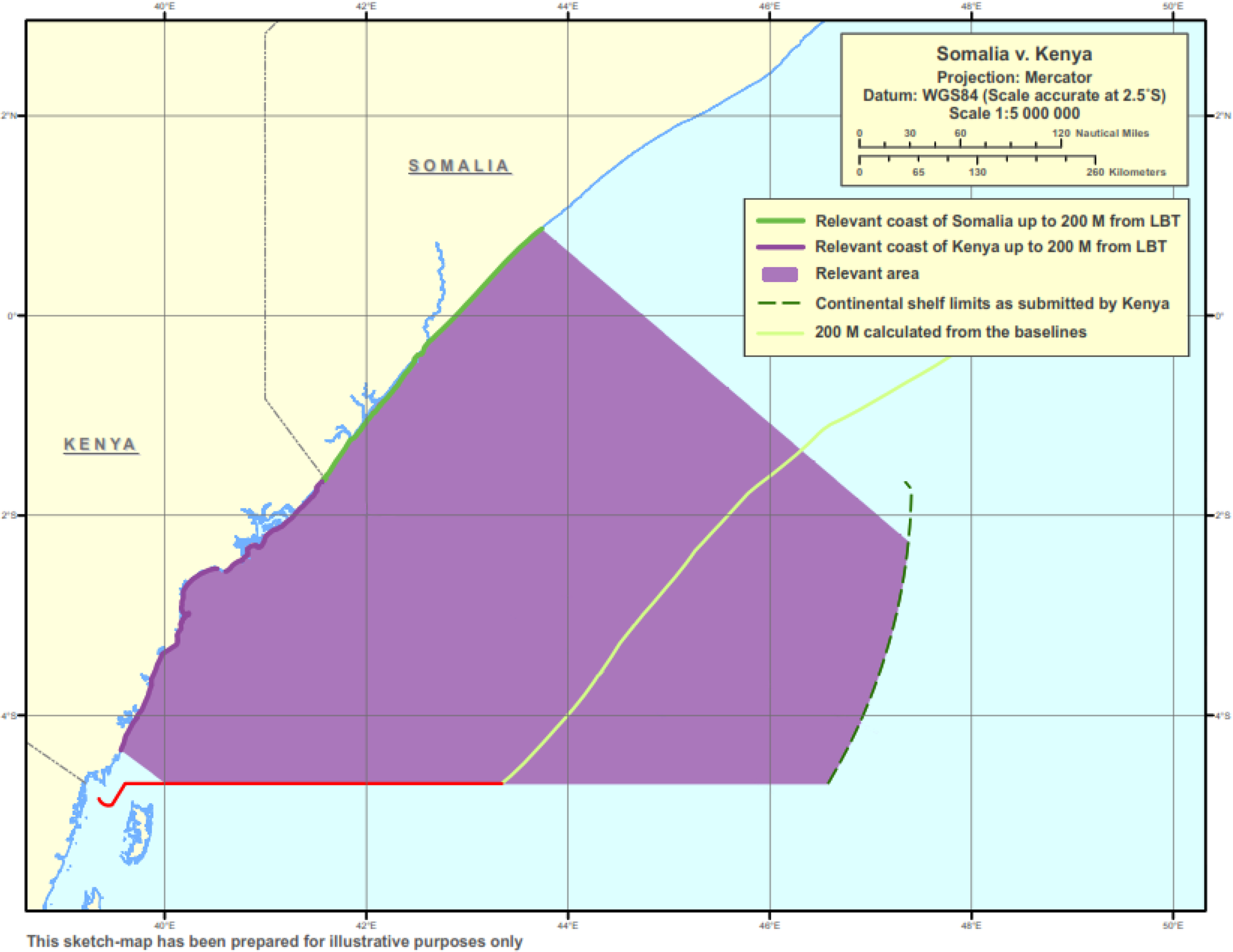
13. The second important aspect that I would like to raise is the consideration of the relevant circumstances. As the Court states in the Judgment, the concept of relevant circumstances is not provided in the Convention but developed through judicial practice (Judgment, paragraph 124). The reason why, so far, there is no exhaustive list of relevant circumstances that have been developed by the Court in maritime delimitation is not difficult to explain. Geographical, economic, and social situations of States differ greatly. There may be historic rights or special interests to be preserved or protected by international law. Maritime delimitation is not just about the sharing of a maritime area. The underlying interests often rest at the heart of the dispute between the parties. When the equidistance method alone cannot fulfil the objective of achieving an equitable solution in all circumstances, the equitable principles should come into play. In essence, the second stage is a crucial means to ensure the equitableness of the final result of the delimitation. If anything, this should be the strength of the three-stage approach.
14. The Court, as the adjudicator, is obliged to take all the relevant circumstances into consideration, on the basis of the evidence and documents adduced by the parties. What circumstance is relevant and what is not must be appreciated by the Court in the context of a specific case. They cannot be predetermined or preset by certain criteria. As Judge Weeramantry pointed out, “one can never foretell what circumstances may surface or achieve importance in the unknown disputes of the future” (Maritime Delimitation in the Area between Greenland and Jan Mayen (Denmark v. Norway), Judgment, I.C.J. Reports 1993, separate opinion of Judge Weeramantry, p. 261, para. 182). The Court might be easily criticized for “excessive subjectivity” in its judgment of such circumstances, but there are good reasons for the Court to maintain its appreciation of the subject-matter. For judicial settlement, even if it cannot be precluded that there are situations where the parties may use the open-endedness of the concept to make excessive claims, it is up to the Court to consider the circumstances and determine what factors to be taken into account in accordance with the equitable principles. So far, the Court has attached legal relevance primarily to geographical circumstances — such as cut-off effect, concavity and convexity, special insular features — which could produce distorting effects on the maritime delimitation. Non-geographical factors have seldom been accepted by the Court as relevant circumstances, although in principle they are not precluded in the jurisprudence of the Court. This tendency in practice, if continued, would likely render the second stage into a purely geometrical exercise, with a few fixed geophysical factors for the Court to consider, thus reducing the discretion of the Court in its appreciation of the situation. Eventually, the three-stage approach would in effect evolve into a substitute of the equidistance method and the equitable principles would vanish from the process of delimitation.
15. The fear that the boundless proliferation of relevant circumstances would open up a risk of assimilating judgments based on law to those rendered ex aequo et bono, in my view, is unfounded, because the notion of relevant circumstances itself is judicially developed and applied. As the Court stated in the North Sea Continental Shelf cases, “when mention is made of a court dispensing justice or declaring the law, what is meant is that the decision finds its objective justification in considerations lying not outside but within the rules” (Judgment, I.C.J. Reports 1969, p. 48, para. 88). The margin of appreciation is to be exercised by the Court, not the parties. Coupled with that discretion, of course, is the responsibility of the adjudicating organ, court or arbitral tribunal, to act reasonably and fairly in the delimitation in accordance with the equitable principles.
16. In the present case, Kenya has raised five factors as the relevant circumstances for the adjustment of the equidistance line, including significant cut-off effect, regional practice of using parallels of latitude to delimit maritime boundaries, vital security interests, long-standing conduct of the Parties in relation to oil concessions, naval patrols and fishing activities, and the impact on the local fisherfolk. The Court rejects all the factors but cut-off effect. Here I fully concur with the reasoning of the Court with regard to the geographical circumstances in the region concerned and the cut-off effect produced by the equidistance line (Judgment, paragraphs 162–171). Sketch-map No. 10 in the Judgment well illustrates the effect of the concavity of the coastline on the delimitation of the maritime boundaries among the three States — Somalia, Kenya and Tanzania. This is a textbook case where the equidistance method could not produce an equitable solution. The equidistance line between Kenya and Tanzania and the equidistance line between Kenya and Somalia both work to the disadvantage of Kenya and, as a result, the Kenyan coast could not produce its effect to a significant extent in terms of its maritime entitlements. As the narrowing effect on Kenya comes from both the northern and southern directions, it is reasonable to make an adjustment in both directions. Such adjustment of the equidistance lines does not give rise to the refashioning of geography. On the contrary, it will rectify the unreasonableness of the equidistance lines, ensuring a fair sharing of the disputed area, which serves the interests of the States concerned in the long run. The maritime boundary agreed between Kenya and Tanzania, as indicated on sketch-map No. 10 of the Judgment, has overcome the cut-off effect to the extent the parties deem reasonable and appropriate. With regard to the equidistance line between Somalia and Kenya, it is for the Court to determine to what extent the line should be adjusted.
17. Between Somalia and Kenya, if all the other factors presented by Kenya are dismissed as non-relevant, one may wonder, other than the proportionality consideration, on what basis the Court could rely to adjust the provisional equidistance line. With the cut-off effect, I am quite persuaded by, and satisfied with, the reasoning of the Judgment for the necessity to adjust the equidistance line, but I am not contented with the way in which the adjustment is done, which brings me to the last point I wish to address.
18. In paragraph 174 of the Judgment, the Court decides to shift the line northwards to an initial azimuth of 114°, in the view that this line would offset the cut-off effect produced by the concavity of the coastal line. Without much explanation as to the reason for this adjustment, the Court moves on to the last stage to verify the result. According to the three-stage methodology, at the final stage, the Court will check whether the adjusted line leads to a significant disproportionality between the ratio of the lengths of the Parties’ respective relevant coasts and the ratio of the sizes of the relevant area apportioned by that line. According to the Court's calculation, the ratio of the relevant coasts between Somalia and Kenya is 1:1.43 in favour of Somalia and the ratio of the apportioned spaces is 1:1:30 in favour of Kenya. The Court is of the view that [a] comparison of these two ratios does not reveal any significant or marked disproportionality” (Judgment, paragraph 176).
19. On the face of the figures, no one can seriously challenge the conclusion of the Court. However, if the identification of the relevant coasts, as has been pointed out before, follows a different method, the proportionality of the ratio of the coastal lengths of the Parties and the ratio of the maritime areas apportioned to the Parties, respectively, will be different. As the following sketch-maps illustrate, the maritime areas apportioned to the Parties in the maritime area within 200 nautical miles are approximately equal, not so favourable to Kenya as stated by the Court. The difference in size between the Parties is getting bigger in the outer continental shelf, in favour of Somalia, provided the outer limits of the continental shelves beyond 200 nautical miles as claimed by the Parties are ultimately confirmed by the CLCS.
Apportionment of the maritime area within 200 nautical miles
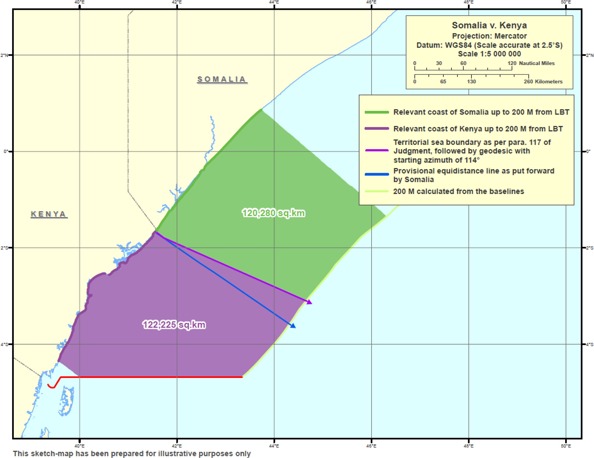
Apportionment of the relevant area including the continental shelf beyond 200 nautical miles
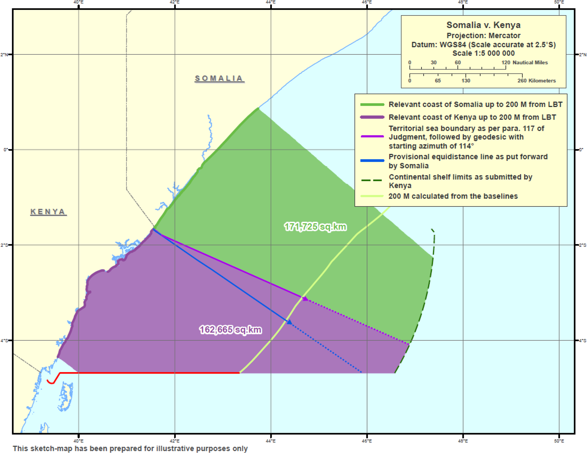
20. For years, international courts and tribunals did not reach agreement on the term “a significant disproportionality”, a criterion that assesses the equitableness of the outcome of maritime delimitation. Under the three-stage approach, the disproportionality test is designed to check, ex post facto, the final result. According to the Court, the disproportionality test is not in itself a method of delimitation; rather, it is a means of checking whether the delimitation line arrived at by other means needs adjustment because of a significant disproportionality in the ratios between the maritime areas which would fall to one party or other by virtue of the delimitation line arrived at by other means, and the lengths of their respective coasts (Maritime Delimitation in the Black Sea (Romania v. Ukraine), Judgment, I.C.J. Reports 2009, pp. 99–100, para. 110). This distinct status and role of the disproportionality test is sound in theory, but in practice it may not play that role. As is demonstrated in this case, when geographical factors are the only relevant circumstances that call for adjustment of the equidistance line, as in the North Sea Continental Shelf cases, proportionality between the two ratios would be the primary consideration for the Court to rely on. Once that is done, how much room is left for the disproportionality test to give its checking effect?
(Signed) Xue Hanqin.
1. In this opinion, I explain the reasons for my disagreement with paragraph 214 (5) of the Judgment and make observations on other parts.
2. Paragraph 214 (5) of the Judgment reads as follows:
“[The Court] . . . [d]ecides that from Point B, the maritime boundary delimiting the continental shelf continues along the same geodetic line until it reaches the outer limits of the continental shelf or the area where the rights of third States may be affected[.]”
3. Since Point B is the outer limit of the exclusive economic zone and continental shelf within 200 nautical miles, the formulation of this paragraph makes clear that the Court has delimited the continental shelf beyond 200 nautical miles. However, for the following reasons, the Court was not in a position to carry out such a delimitation.
4. First, the régime for a coastal State's entitlement to a continental shelf within 200 nautical miles is different from the régime for its entitlement to a continental shelf beyond 200 nautical miles, and it is this difference that makes the Court's finding in paragraph 214 (5) questionable. Article 76 (1) of the United Nations Convention on the Law of the Sea (hereinafter “UNCLOS” or the “Convention”) provides as follows:
“The continental shelf of a coastal State comprises the sea-bed and subsoil of the submarine areas that extend beyond its territorial sea throughout the natural prolongation of its land territory to the outer edge of the continental margin, or to a distance of 200 nautical miles from the baselines from which the breadth of the territorial sea is measured where the outer edge of the continental margin does not extend up to that distance.”
5. Although the Convention defines the continental shelf in geological and geomorphological terms as the sea-bed and subsoil of the submarine areas throughout the natural prolongation of its land territory to the outer edge of the continental margin, it also provides that, in cases where the outer edge of the continental margin does not extend to 200 nautical miles from the baselines from which the breadth of the territorial sea is measured, the continental shelf will extend to that distance. In effect, therefore, the distance criterion supersedes the geological and geomorphological criteria in defining a coastal State's entitlement to a continental shelf up to 200 nautical miles. However, where, as here, the question relates to a State's entitlement to a continental shelf beyond 200 nautical miles, different considerations apply.
6. In order to determine a State's entitlement to a continental shelf beyond 200 nautical miles there must be in existence a continental margin that extends beyond 200 nautical miles because, by virtue of Article 76 (1) of the Convention, the continental shelf extends to the outer edge of the continental margin. Paragraph 3 of Article 76 of the Convention defines the margin as “compris[ing] the submerged prolongation of the land mass of the coastal State, and consist[ing] of the sea-bed and subsoil of the shelf, the slope and the rise”. Therefore, in order to delimit, the Court must have before it reliable evidence that there is in existence, in the area beyond 200 nautical miles, a “submerged prolongation of the land mass of the coastal State”. According to paragraph 6 of Article 76 of the Convention, the outer limit of the continental shelf “shall not exceed 350 nautical miles from the baselines from which the breadth of the territorial sea is measured”.
7. Thus, in relation to the delimitation of the continental shelf beyond 200 nautical miles, geological and geomorphological criteria supersede the distance criterion, because there can be no entitlement to a continental shelf in the area beyond 200 nautical miles and up to a distance of 350 nautical miles, unless there is certainty that there is in existence a continental margin in that area. Since under the Convention a coastal State's entitlement to a continental shelf beyond 200 nautical miles is determined by geological and geomorphological factors, the Court must ensure that those factors exist before delimiting the continental shelf beyond 200 nautical miles.
8. The distinction between delineation of the outer limit of the continental shelf by the Commission on the Limits of the Continental Shelf (hereinafter the “CLCS” or “Commission”) and maritime delimitation by the Court is clear. It is equally clear that recommendations by the CLCS on the outer limit of the continental shelf do not constitute a necessary precondition for maritime delimitation by the Court. But in order to carry out such a delimitation, the Court must have reliable evidence confirming the existence of a continental shelf in the area beyond 200 nautical miles.
9. The Judgment reflects an awareness of the requirement that the Court must have at hand reliable information confirming the existence of a continental margin in the area beyond 200 nautical miles if it is to be in a position to carry out a delimitation in that area. However, as will be seen, the Court ignores this requirement.
10. After citing Article 76 (4) of the Convention, the Judgment concludes that “[t]he entitlement of a State to the continental shelf beyond 200 nautical miles thus depends on geological and geomorphological criteria. An essential step in any delimitation is to determine whether there are entitlements, and whether they overlap” (paragraph 193). The Court noted that the Tribunal in Bangladesh/Myanmar was only able to carry out delimitation of the shelf beyond 200 nautical miles because of what the Tribunal described as the “unique situation in the Bay of the Bengal”, a feature which the Judgment states explicitly “is not the same as [present case]”. The Special Chamber of the International Tribunal for the Law of the Sea (“ITLOS”) in Ghana/Côte d’Ivoire held that it “can delimit the continental shelf beyond 200 [nautical miles] only if such a continental shelf exists”Footnote 1, and that it had the benefit of the Commission's affirmative recommendations in relation to Ghana; it also observed that the “geological situation [of Côte d’Ivoire was] identical to that of Ghana”Footnote 2. The Special Chamber emphasized that there is “no doubt that a continental shelf beyond 200 [nautical miles] exists in respect of the two Parties”Footnote 3. The need for a court or tribunal to be certain about the existence of a continental shelf beyond 200 nautical miles if it is to carry out a delimitation in that area was also emphasized by the Tribunal in Bangladesh/Myanmar. The Tribunal stated that it would have been hesitant to proceed to delimit the area beyond 200 nautical miles if there was uncertainty about the existence of a shelf in that areaFootnote 4.
11. As if to contradict the cautionary note it had sounded in relation to any reliance on the decisions in Bangladesh/Myanmar and Ghana/Côte d’Ivoire, the Court in paragraph 194 rather unexpectedly announced its decision to delimit the continental shelf boundaries up to the outer limit of the continental shelf.
12. It is ironical that, having taken the pains to isolate and identify the critically relevant information that ITLOS and its Special Chamber had in the Bangladesh/Myanmar and Ghana/Côte d’Ivoire cases, the Court proceeded to delimit the Parties’ continental shelf in the area beyond 200 nautical miles without any convincing evidence as to the existence of a shelf beyond 200 nautical miles. This contrasts with the decision of the Court in Nicaragua v. Colombia not to delimit the continental shelf beyond 200 nautical miles, because Nicaragua relied on information it had submitted to the CLCS that did not substantiate its claim to a continental shelf beyond 200 nautical milesFootnote 5.
13. The Judgment is bereft of even a scintilla of reliable evidence that the geological and geomorphological criteria, which the Judgment itself refers to in paragraph 193 as being essential in the determination of State entitlements, have been met.
14. The Court comes closest to identifying evidence of the existence of a continental shelf beyond 200 nautical miles when it noted “that in their submissions to the Commission both Somalia and Kenya claim on the basis of scientific evidence a continental shelf beyond 200 nautical miles and that their claims overlap” (paragraph 194 of the Judgment). However, this observation does not provide a sufficient basis for the delimitation because nowhere in the Judgment is there any reference to the content of this scientific evidence and, more importantly, nowhere in the Judgment is there any analysis of that content to show that the Court is satisfied that the necessary geological and geomorphological criteria have been met for the existence of a continental shelf beyond 200 nautical miles. It must be made clear that in this case the Court was not asked to examine any scientific data that would establish the existence of a continental shelf beyond 200 nautical miles. It is, of course, perfectly proper to refer to the Parties’ submissions to the Commission. However, if it relies on these submissions, the Court must explain why it finds them persuasive. Such an explanation is the more necessary where, as in this case, the Commission has not yet made any recommendations on the submissions of the Parties. Thus, it appears that the principal factors that explain the Court's decision to delimit the continental shelf beyond 200 nautical miles are the criterion of the 350-nautical-mile distance as the outer limit of the continental shelf and the volition of the Parties to have the Court effect a delimitation. But, in delimiting the continental shelf beyond 200 nautical miles, geological and geomorphological factors supersede distance as the criteria for determining a State's entitlement to that shelf, thereby rendering less consequential the request of the Parties to have the Court effect a delimitation in that area.
15. The lack of any evidence of geological and geomorphological data to substantiate the existence of a continental shelf, and thus, of the entitlement of the Parties to a continental shelf beyond 200 nautical miles, undermines the validity of the finding in paragraph 214 (5), which is the principal conclusion of the Court in the part of its Judgment devoted to the delimitation of the continental shelf beyond 200 nautical miles. Nonetheless, the present opinion will comment on other aspects of the Judgment relating to this finding.
16. Second, in the delimitation of the continental shelf in the area beyond 200 nautical miles the Court has overvalued the volition of the Parties and the fact that “neither Party questions the existence of the other Party's entitlement to a continental shelf beyond 200 nautical miles or the extent of that claim” (paragraph 194 of the Judgment). In the delimitation of the continental shelf up to 200 nautical miles, it is appropriate for the Court to act entirely on requests of the Parties for it to carry out such a delimitation, because in that area the distance criterion of 200 nautical miles prevails. However, where, as here, the Court is delimiting the continental shelf in the area beyond 200 nautical miles, the requests of the Parties, and the congruence of their views as to their respective entitlement to a shelf beyond 200 nautical miles and the extent of that entitlement, do not constitute a sufficient basis for delimitation in that area. By effecting a delimitation of a party's continental shelf beyond 200 nautical miles without any reliable evidence of the existence of a shelf in that area, the Court has effectively eliminated the important difference drawn by the Convention between a coastal State's entitlement to a shelf within and beyond 200 nautical miles. In the result, by delimiting on the presumption that the Parties are entitled to a shelf up to 350 nautical miles, the Court has replaced the geological and geomorphological criteria required by the Convention for such an entitlement with a simple distance criterion of a maximum of 350 nautical miles. There is nothing in the Judgment that comes close to the categoric findings in Bangladesh/Myanmar and Bangladesh v. India cases as to the existence of a continental shelf beyond 200 nautical miles.
17. Third, the Court has carried out a delimitation of the continental shelf beyond 200 nautical miles in an environment riddled with uncertainty. Although the use of a directional arrow, such as the one contained in sketch-map No. 13, is not uncommon in delimitation of the continental shelf beyond 200 nautical miles, there must be some doubt as to whether this approach provides the level of certainty that one would expect in an exercise as consequential as the delimitation of a boundary between two States, which will have sovereign rights in the area attributed to them.
18. This uncertainty is even more evident in paragraph 197 of the Judgment, which reads:
“Depending on the extent of Kenya's entitlement to a continental shelf beyond 200 nautical miles as it may be established in the future on the basis of the Commission's recommendations, the delimitation line might give rise to an area of limited size located beyond 200 nautical miles from the coast of Kenya and within 200 nautical miles from the coast of Somalia, yet on the Kenyan side of the delimitation line (“grey area”).” (Emphasis mine.)
This reasoning is a conjecture built on a surmise founded on a hypothesis — scarcely a basis for the construction of a legal régime. Regrettably, the grey area that it identifies is not of “limited size”, but in the circumstances of this case, may be seen as applying to the entire area beyond 200 nautical miles. It is noted, however, that the Court decided not to address the question of the legal régime that would be applicable to this grey area.
19. Notwithstanding that delineation of the outer limits of the continental shelf is carried out by coastal States on the basis of the recommendations of the CLCS, and not by the Court, there must be a concern that delimitation and delineation exercises may impact adversely on the Area, defined in Article 1 (1) of the Convention as “the sea-bed and ocean floor and subsoil thereof, beyond the limits of national jurisdiction”. The Area therefore begins where national jurisdiction ends. Article 136 provides that “[t]he Area and its resources are the common heritage of mankind”; Article 140 (1) provides that activities in the Area are to be carried out “for the benefit of mankind as a whole . . . and taking into particular consideration the interests and needs of developing States”. During the UNCLOS negotiations, generally, developing countries attached the greatest importance to the establishment of a meaningful régime for the Area in the expectation that its exploration and exploitation would contribute to their growth and development in the interest of the common heritage of mankind.
20. Concerns about the possible impact of delimitation on the régime for the Area were expressed by the Arbitral Tribunal in the France-Canada Maritime Delimitation case (St. Pierre and Miquelon), in which France had requested delimitation of the continental shelf beyond 200 nautical miles. The Commission stated:
“Any decision by this Court recognizing or rejecting any rights of the parties over the continental shelf beyond 200 nautical miles, would constitute a pronouncement involving a delimitation, not ‘between the Parties’ but between each one of them and the international community, represented by organs entrusted with the administration and protection of the international sea-bed Area (the sea-bed beyond national jurisdiction) that has been declared to be the common heritage of mankind.”Footnote 6
While this Award, made not very long after the adoption of the Convention, may be seen as going too far, its underlying concern should not be disregarded: where it is appropriate, the interests of the international community in exploring and exploiting the Area is a factor that must be taken into account in maritime delimitation in the area beyond 200 nautical miles. Moreover, in the Bangladesh/Myanmar case the Tribunal expressly considered the possible impact of the delimitation of the shelf beyond 200 nautical miles on the interests of the international community in the Area, and determined in the following finding that those interests were not affected:
“In addition, as far as the Area is concerned, the Tribunal wishes to observe that, as is evident from the Parties’ submissions to the Commission, the continental shelf beyond 200 nm that is the subject of delimitation in the present case is situated far from the Area. Accordingly, the Tribunal, by drawing a line of delimitation, will not prejudice the rights of the international community.”Footnote 7
A fair inference from this finding is that the Tribunal would not have carried out the delimitation requested or, at any rate, would have given serious thought to declining that delimitation, had it found that this delimitation was to be carried out in an area that was near to the Area in which the international community has an interest. It would seem that, in the instant case, a statement similar to that of the Tribunal in Bangladesh/Myanmar could not be made by the Court, because the continental shelf that is the subject of delimitation could possibly extend to the Area. Nonetheless the Tribunal's dictum is instructive in that it signifies an appropriate sensitivity to the interests of the international community in the Area.
21. Fourth, Article 83 (1) of the Convention requires that the delimitation of the continental shelf be effected by agreement on the basis of international law in order to achieve an equitable solution. In the delimitation of the continental shelf within 200 nautical miles, the Court quite properly spent much time considering whether its three-stage methodology produced an equitable solution. On the other hand, in the delimitation of the continental shelf beyond 200 nautical miles, the Judgment is silent on the question whether the methodology the Court has used produces an equitable solution. This is a significant omission in the Judgment and it raises serious questions as to whether the delimitation carried out has been effected in accordance with the Convention.
Concavity
The significance of the Kenyan “concavity”
22. The best statement of the law on the relationship between a relevant circumstance, a concavity, the median line and a cut-off effect is the finding of the ITLOS in Bangladesh/Myanmar that
“concavity per se is not necessarily a relevant circumstance. However, when an equidistance line drawn between two States produces a cut-off effect on the maritime entitlement of one of those States, as a result of the concavity of the coast, then an adjustment of that line may be necessary in order to reach an equitable result.”Footnote 8
23. The question is whether the cut-off effect produced by the equidistance line must result from a geographical feature that meets the minimum requirements for a concavity or whether it can result from any geographical feature, such as a mere curvature or an indentation, even if that feature does not meet the minimum requirements for a concavity. Case law is generally unhelpful in identifying the minimum features for a concavity to result in the equidistance line producing a cut-off effect that requires its adjustment in order to achieve an equitable solution. The comments that one finds on this question are of a general nature; for example, in Ghana/Côte d’Ivoire, the Special Chamber found “that the coast of Côte d’Ivoire is concave, although such concavity is not as pronounced as in, for example, the case of the Bay of Bengal”Footnote 9.
24. In the 1969 North Sea Continental Shelf cases, the Court found that the German coast was “markedly concave”Footnote 10. It is not for nothing that in considering the German concavity, the Court referred to another coastline, that of Bangladesh, that was also markedly concave. Indeed, in Bangladesh/Myanmar, ITLOS held that the Bangladesh coast was “manifestly concave” and that, consequently, the equidistance line produced a cut-off effect warranting the adjustment of that line. One may also consider the Court's decision in Costa Rica v. Nicaragua. However, that decision is not apposite because the Court did not examine in detail whether a concavity existed, but simply confined itself to the conclusion that the existence of a concavity did not produce a cut-off effect warranting an adjustment of the equidistance line. This is to be contrasted with the instant case in which the majority has found not only that there is a concavity, but that “[w]hen the mainland coasts of Somalia, Kenya and Tanzania are observed together, as a whole, the coastline is undoubtedly concave” and that, consequently, the equidistance line produces a cut-off effect that warrants some adjustment of that line. In Cameroon v. Nigeria, the Court found that there was no concavity in the sectors of the coastline relevant to the present delimitationFootnote 11. In Guinea/Guinea-Bissau, the Tribunal found that the coastline of Guinea-Bissau, Guinea and Sierra Leone, when considered together, was generally concaveFootnote 12.
25. In accordance with the Court's jurisprudence therefore, an adjustment of the equidistance line is only required when it produces a cut-off effect as a result of a coastal feature that is obviously concave or, to use the language of the Court in North Sea Continental Shelf cases, “markedly concave” or that of the Tribunal in Bangladesh/Myanmar, “manifestly concave”. That the Court did not have in mind a cut-off effect resulting from a slight curvature or an indentation in a coast is clear from its finding in Libya/Malta 16 years later, that an equidistance line “may yield a disproportionate result where a coast is . . . markedly concave or convex”Footnote 13. Here the Court was restating its finding in the 1969 North Sea Continental Shelf cases that an equidistance line may yield disproportionate results when a coastal feature has a concavity or convexity that would have the effect of pulling the line inwards or outwards. What is significant is that the Court found that this outcome must be the result of a markedly concave or convex coast.
26. The phrase, “as a consequence of a concavity” in the ITLOS dictum makes clear that the cut-off effect must result from a concavity, that is, a geographical feature that causes an equidistance line to produce a cut-off effect, warranting its adjustment in order to achieve an equitable result. The phrase has special significance in that it emphasizes the very important causal role that the concavity plays in the equidistance line producing a cut-off effect. If a geographical feature that is a mere curvature or an indentation rather than a concavity, produces a cut-off effect, then that effect is to be ignored, because to recognize it as capable of leading to an adjustment of the equidistance line would be to refashion geography and an equitable solution would not be achieved. The well-known proposition that maritime delimitation should not result in refashioning geography is reflected in paragraph 172 of the Judgment.
27. It can be inferred from the ITLOS dictum (cited above in paragraph 26) that it is not any and every geographical feature that will be sufficient to constitute a relevant circumstance; it is only a geographical feature meeting the minimum requirement for a concavity and producing a cut-off effect that will constitute a relevant circumstance requiring adjustment of the provisional equidistance line. Regrettably, the Special Chamber's decision in Ghana/Côte d’Ivoire is inconsistent with the Court's jurisprudence that an adjustment of the equidistance line is only required when it produces a cut-off effect as a result of a coastal feature that is markedly concave. The effect of the Special Chamber's ruling in that case is that a coastal feature that would appear to be nothing more than a mere curvature constituted a concavity. However, the Chamber only found that there was a cut-off effect when the convexity of the Ghanaian coastline was also taken into account, and in any event, it found that the cut off did not warrant an adjustment of the equidistance line. The decision of the Arbitral Tribunal in Guinea/Guinea-Bissau is also inconsistent with the aforementioned jurisprudence of the Court.
28. Although one cannot identify, with a fine degree of certainty, the minimum requirements for a concavity sufficient to produce a cut-off effect that calls for an adjustment of the provisional equidistance line, of the several coastal features considered in the previous paragraphs, it is only those of Germany and Bangladesh that would appear to meet those requirements. It is only those coastal features that can be said to be markedly concave. As will be seen in the sketch-maps below, it is only those coastal features that, on their face, resemble a concavity in that they possess a shape that is markedly hollowed or markedly rounded inward like the inside of a bowl (Merriam-Webster's Dictionary). The more relaxed view of what constitutes a concavity, evident in Ghana/Côte d’Ivoire and Guinea/Guinea-Bissau, has not displaced the clear finding of the Court that it is a markedly concave coastal feature that produces a cut-off effect, calling for an adjustment of the provisional equidistance line.
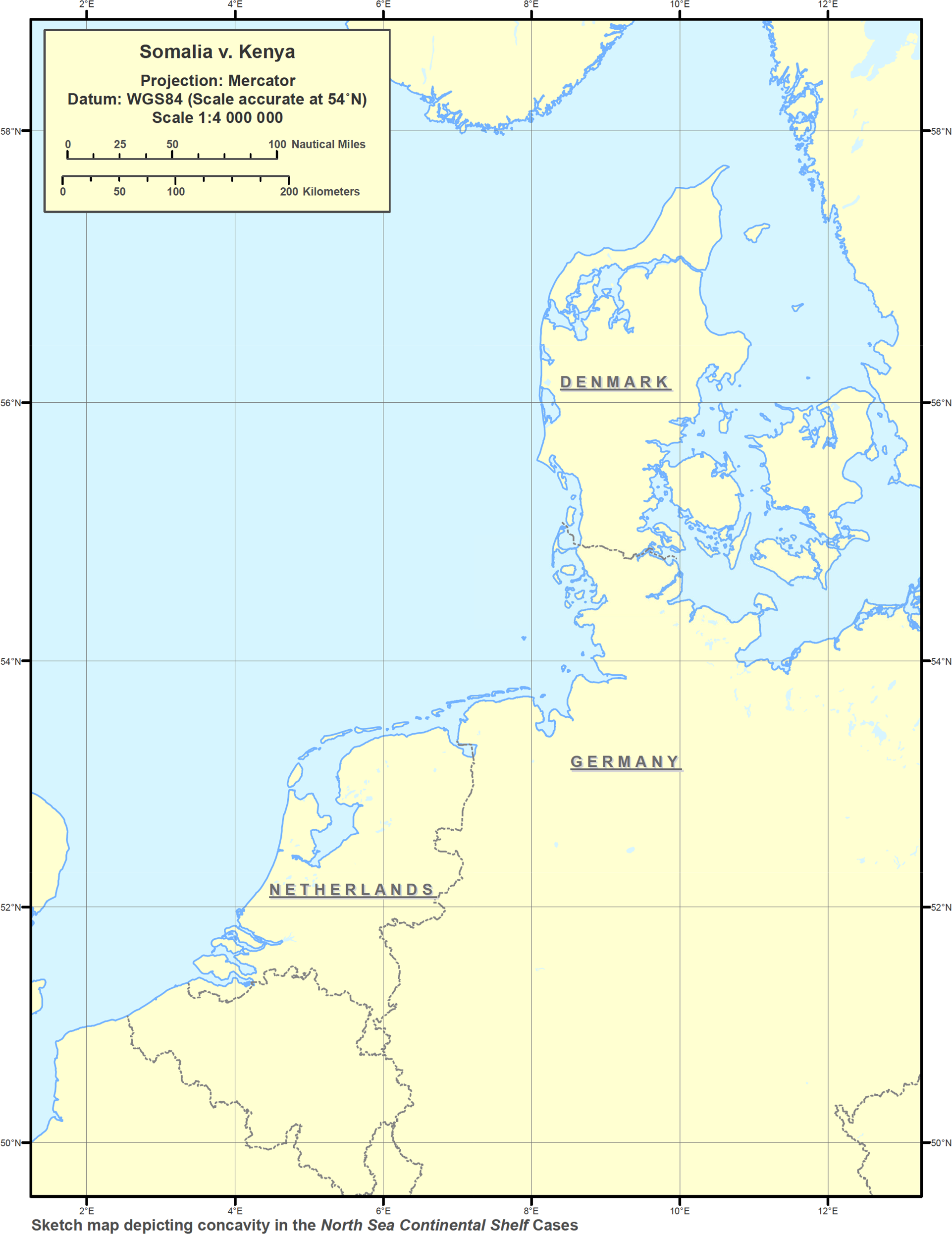


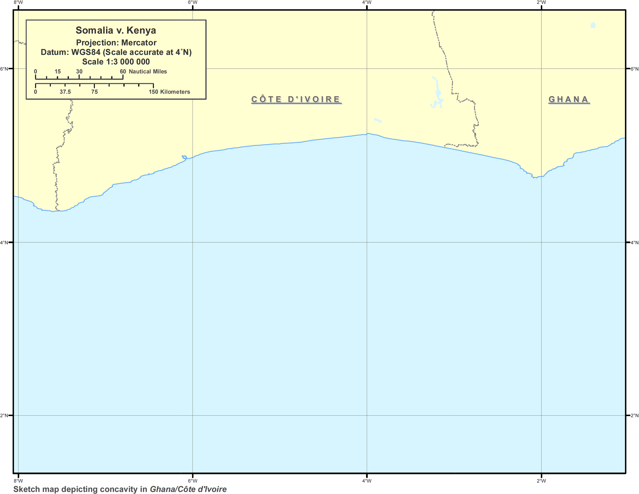


29. In the instant case, there must be a doubt as to whether the curvature in the Kenyan coast or, for that matter, the curvature in the Somali, Kenyan and Tanzanian coasts, has the degree of concavity sufficient to result in the equidistance line producing a cut-off effect, requiring an adjustment of that line. Certainly, the greater part of the Kenyan coastline may fairly be described as a slight curvature. Since, in the result, the Court has held this curvature to be a concavity, the reasonable doubt that exists as to whether the feature constitutes a concavity means that any cut-off resulting would only warrant the slightest adjustment of the equidistance line, because that line does not in any significant way prevent Kenya from achieving its maximum maritime area in accordance with international law; in fact, the better view might very well be that no adjustment is warranted since the cut-off is neither serious nor severe.
30. In considering the curvature in the Somali, Kenyan and Tanzanian coasts as part of what the Judgment describes as the “broader geographical configuration”, the Court has followed the Tribunal's decision in Guinea/Guinea-Bissau rather than its Judgment in Cameroon v. Nigeria. In the former case, the Tribunal considered the coastline of Guinea, Guinea-Bissau and Sierra Leone together; in the latter case, the Court was explicit in its finding that the Cameroonian concavity could only be a relevant circumstance “when such concavity lies within the area to be delimited”Footnote 14. In order to show that the Cameroonian concavity did not meet that requirement, the Court observed that it was not facing Nigeria, but rather, the island of Bioko, that belonged to a third State, and was not within the area to be delimited. The Judgment has wrongly seized on this reference by the Court to an island of a third State to conclude that “the Court's statement thus should not be understood as excluding in all circumstances the consideration of the concavity of a coastline in a broader geographical configuration”. But there is nothing in the Court's finding to suggest that it was embracing the notion of a broader geographical configuration; rather, in order to dismiss the Cameroonian claim that its concavity was a relevant circumstance, the Court merely observed that the concavity was located in a third State, and that it was not a relevant circumstance since it was not within the area to be delimited. Significantly, the Court referred to the third State, not to take its concavity into account, but to exclude it from the maritime delimitation between Cameroon and Nigeria on the basis that it was not within the area to be delimited. In contrast, in the instant case, the Court refers to the “concavity” of a third State, Tanzania, not to exclude it from the maritime delimitation between Somalia and Kenya, but to include it in that delimitation. The proposition that, in maritime delimitation, account should be taken of a concavity that is not within the area to be delimited but is part of a so-called broader geographical configuration, is problematic. In the first place, the concept of a “broader geographical configuration” is itself broad and vague — where the configuration begins and ends is a legitimate question. But the real danger is that the cut-off effect may result more from the geographical feature of a third State — not a party to the dispute and not in the delimitation area — than from the geographical feature on the coast of the State that is a party to the dispute and is within the area to be delimited. This would appear to be so in the present case because the Tanzanian “concavity”, that is not within the area to be delimited, appears more pronounced than the Kenyan “concavity”, that is within the area to be delimited. The odd result is a refashioning of geography whereby an adjustment is made to the equidistance line, more on account of a “concavity” in the Tanzanian coastline than of the “concavity” in the Kenyan coastline — a result that is wholly inconsistent with the Court's finding in Cameroon v. Nigeria that, in order to qualify as a relevant circumstance for the purpose of adjusting the equidistance line, the concavity must be within the area to be delimitedFootnote 15. Somalia would appear to have been disadvantaged by reason of a “concavity” that is not within the area to be delimited — an outcome that can scarcely be described as equitable.
31. In support of its decision to take into account the “concavity” in the Tanzanian coast as part of a broader geographical configuration, the Court cites its finding in the 1969 North Sea Continental Shelf cases that “although two separate delimitations were in question, they involved — indeed actually g[a]ve rise to — a single situation”Footnote 16. However, there is an important difference between those cases and the instant case. In the 1969 cases, the Court joined cases brought separately by Germany against the Netherlands and against Denmark, with the result that the maritime areas produced by the coasts of the Netherlands, Denmark and Germany constituted the delimitation area. Thus, there was no question of the maritime areas of the Netherlands and Denmark, between which the German concavity lies, not being within the area to be delimited. In contrast, Tanzania is not a party to the dispute between Somalia and Kenya, and its “concavity” is not within the area to be delimited. The need for a concavity to be located within the area to be delimited, if it is to qualify as a relevant factor requiring adjustment of the equidistance line, was reiterated by the Court in Cameroon v. Nigeria.
32. There is another important distinction between the 1969 cases and the instant case. As a result of the joinder, the Court had before it submissions from the two adjacent coastal States, the Netherlands and Denmark. In contrast, in the instant case the Court has no submissions from Tanzania, which is not a party to the dispute and whose “concavity” does not lie within the area to be delimited.
33. In sum, the Court's Judgment in the 1969 cases does not authorize the proposition that in maritime delimitation account may be taken of a concavity that is not within the area to be delimited merely because it falls within a so-called “broader geographical configuration”. Therefore, the “single situation” to which the Court referred in the 1969 cases does not eliminate the need for the concavity to fall within the area to be delimited if it is to qualify as a relevant factor warranting an adjustment of the provisional equidistance line.
The status of the 1927/1933 treaty arrangement
34. There is a question whether the Court has interpreted and applied the 1927/1933 treaty arrangement. In order to address this question, the following paragraphs of the Judgment must be examined. Paragraph 109 states: “In light of the above, the Court therefore considers it unnecessary to decide whether the 1927/1933 treaty arrangement had as an objective the delimitation of the boundary in the territorial sea.”
Paragraph 118 states:
“The Court observes that the course of the median line as described in paragraph 117 corresponds closely to the course of a line ‘at right angles to the general trend of the coastline’, assuming that the 1927/1933 treaty arrangement, in using this phrase, had as an objective to draw a line that continues into the territorial sea, a question that the Court need not decide (see paragraph 109 above).”
Paragraph 214 (2) reads as follows:
“[The Court] . . . [d]ecides that the starting-point of the single maritime boundary delimiting the respective maritime areas between the Federal Republic of Somalia and the Republic of Kenya is the intersection of the straight line extending from the final permanent boundary beacon (PB 29) at right angles to the general direction of the coast with the low-water line at the point with co-ordinates 1° 39′ 44.0" S and 41° 33′ 34.4" E (WGS 84)[.]”
35. An examination of paragraphs 109 and 118 reveals that the Court has interpreted the treaty arrangement. The Court could not have concluded that there was a close correspondence between the median line as described in paragraph 117 and the course of a line “at right angles to the general trend of the coastline” without examining and interpreting that phrase, which is to be found in the 1927/1933 treaty arrangement. However, it might also be argued that, in this paragraph, the Court has not only interpreted the colonial treaty but also applied it. This is not a view that I share, but it cannot be ruled out of consideration. My own position is that paragraph 214 (2) of the dispositif confirms that the Court has not applied the 1927/1933 treaty arrangement because the starting-point identified — “the intersection of the straight line extending from the final permanent boundary beacon (PB 29) at right angles to the general direction of the coast with the low-water line,” — is not the starting-point set out in the 1927/1933 treaty arrangement. This paragraph of the dispositif does not use the phrase “at right angles to the general trend of the coastline”, which is to be found in paragraph 118, and placed in quotation marks to indicate that it is taken from the 1927/1933 treaty arrangement. This paragraph, in its reference to the low-water line as the starting-point of the boundary, reflects Article 5 of the Convention, which is the applicable law for the Parties, since both States are parties to that Convention. Although it may be said that the formulation of this paragraph is influenced by the 1927/1933 treaty arrangement, it cannot be concluded, that in determining the starting-point the Court has applied the 1927/1933 treaty arrangement.
36. An interesting feature of this case is that although the part of this Judgment relating to the territorial sea is replete with references to the 1927/1933 treaty arrangement, and although the Court has quite plainly interpreted that treaty, there is nothing that explains how the Court is in a position to take cognizance of this treaty.
37. The dispute brought before the Court relates to differences between Somalia and Kenya. The 1927/1933 treaty arrangement relates to treaties between Italy and United Kingdom. By what legal theory or jurisprudential principle does the Court have the power to interpret the treaties between Italy and the United Kingdom? The Judgment does not explain how, in the absence of the Parties conferring jurisdiction on it in respect of the colonial treaties, the Court takes cognizance of these treaties. There must be an explanation as to how the colonial treaties between Italy and the United Kingdom become relevant to the dispute between Somalia and Kenya. It cannot even be maintained that there is a link between the treaty arrangement and the dispute on the basis that both cover the same geographical area, because the treaties establish a land boundary while the dispute between the Parties relates to the sea. However even if both the treaties and the dispute covered the same geographical area, that would not provide a sufficient link with Somalia and Kenya — States that were not parties to the 1927/1933 treaty arrangement. Indeed, in relation to Somalia and Kenya, the treaty is res inter alios acta. The closest that the Judgment comes to discussing the relationship between the 1927/1933 treaty arrangement and the dispute is in paragraph 32. In that paragraph, after outlining the various instruments described as the 1927/1933 treaty arrangement between Italy and the United Kingdom, there is a terse reference to Somalia and Kenya gaining their independence in 1960 and 1963 respectively. However, no link is made between the colonial treaties and the attainment of independence between Somalia and Kenya.
38. There was adopted in 1978 the United Nations Convention on Succession of States in respect of Treaties (hereinafter referred to as the “1978 Vienna Convention”). It defines a succession of States as “the replacement of one State by another in the responsibility for the international relations of territory”.
39. The 1978 Vienna Convention required ratification by 15 States to enter into force. Following its adoption, the treaty took 18 years to enter into force and today, 43 years after its adoption, it only has 23 States parties or about 12 per cent of the membership of the United Nations. Obviously it has not gained any significant support. The reason is explained below.
40. By virtue of that Convention a newly independent State begins its life free from any obligation to continue or maintain the treaties of its predecessor, but with an entitlement to continue or maintain those treaties if it so wishes. This principle is reflected in Article 16 which provides that “[a] newly independent State is not bound to maintain in force, or to become a party to, any treaty by reason only of the fact that at the date of the succession of States the treaty was in force in respect of the territory to which the succession of States relates”. In my view, the provision is protective of the sovereignty of the newly independent States because it does not impose an obligation on them to continue the treaties of a predecessor State and at the same time it leaves those States with an entitlement to continue those treaties if they wish.
41. Notwithstanding the apparent potential of Article 16 to attract newly independent States to ratify the 1978 Convention, only few have done so. In the Caribbean, for example, only Dominica and Saint Vincent and the Grenadines are parties and from Africa only Egypt, Ethiopia, Liberia, Morocco, Seychelles and Tunisia are parties. Somalia and Kenya are not parties. There is obviously a strong antipathy to this Convention on the part of the vast number of developing countries that became independent after 1960. The overriding reason for this opposition is Article 11 which provides that “[a] succession of States does not as such affect: (a) a boundary established by a treaty; or (b) obligations and rights established by a treaty and relating to the regime of a boundary”. Therefore, to the extent that the 1927 Agreement established a boundary, that boundary is not affected as such by the succession of States that took place on the independence of Somalia and Kenya. The significance of the phrase “as such” is that — as the International Law Commission's Commentary indicates — Article 11 “relate[s] exclusively to the effect of the succession of States on the boundary settlement”, “leav[ing] untouched any other ground of claiming the revision [of the treaty] or setting aside of the boundary settlement, whether self-determination or the invalidity or termination of the treaty”Footnote 17. In my view, the 1927/1933 treaty arrangement did not establish a boundary in the territorial sea.
42. Article 11 of the 1978 Vienna Convention provides for an exception to the general rule in Article 16 that a newly independent State is not bound to maintain the treaties of its predecessor, but may do so if it wishes. Newly independent States did not wish to bind themselves to a treaty that obligated them to maintain boundaries established by their predecessor States. Nonetheless the Organization of African Unity adopted a resolution in 1964 that its members would “respect the borders existing on their achievement of national independence”Footnote 18, and many argue that there is a customary rule of international law requiring respect for such borders.
43. The Judgment does not determine whether the 1927/1933 treaty arrangement establishes a boundary in the territorial sea. It is patent that the Judgment seeks to adopt an approach that would arrive at a conclusion about the delimitation of the territorial sea without any reference to the colonial treaties. Nonetheless, as is evident in paragraphs 109 and 118, the Judgment does not seem capable of escaping references to those treaties.
44. If the jurisprudential basis for the Court's interpretation of the treaty arrangement is not the principle of a succession of States, reflected in the 1978 Vienna Convention, then in my view, it must be that the colonial treaties between Italy and the United Kingdom become relevant to the Court's adjudication in the dispute between Somalia and Kenya on the basis of the right to self-determination. When Somalia became independent in 1960, it assumed sovereignty over territory in respect of which Italy formerly exercised sovereignty; in particular, it assumed responsibility for the conduct of foreign relations in respect of that territory. Similarly, when Kenya became independent in 1963, it assumed sovereignty over territory in respect of which the United Kingdom formerly exercised sovereignty; in particular it assumed responsibility for the conduct of foreign relations in respect of that territory. The right to self-determination reflected in resolution 1514 (XV) of the United Nations General Assembly, enables both Somalia and Kenya to determine the conduct of their foreign relations, including whether to maintain the treaties entered into by Italy and the United Kingdom in respect of the territory over which they now exercise sovereignty. This is confirmed by Article 2 of resolution 1514 (XV) which provides that “[a]ll peoples have the right to self-determination; by virtue of that right they freely determine their political status and freely pursue their economic, social and cultural development”. The right to self-determinationFootnote 19 as reflected in resolution 1514 (XV) was already a rule of customary international law at the time of the independence of Somalia and Kenya.
45. In response to a question by a Member of the Court, Somalia stated that “[n]either [it] nor Kenya, since their independence and at all times thereafter, has ever claimed that the maritime boundary in the territorial sea follows a line perpendicular to the coast at Dar es Salam, for any distance”. It further added that neither Party accepted nor argued for the 1927 Agreement as binding on them in regard to a maritime boundary, for any distance. In exercise of their sovereignty and independence Somalia and Kenya had the right to determine their relationship with the colonial treaties, that is, whether they accepted or rejected them. These two statements by Somalia, indicating the Parties’ non-reliance and non-acceptance of the colonial treaties, classically reflect the exercise of the right to self-determination by newly independent States. Consequently, those treaties are inapplicable in the determination of the maritime dispute between Somalia and Kenya. Since those treaties did not establish a boundary in the territorial sea, the question whether there is an obligation under customary international law to respect boundaries that existed at independence does not arise.
Acquiescence
46. Acquiescence, like the kindred concept of estoppel, owes its place in international law primarily to Anglo-American law. In international law, acquiescence applies to cases where, although a State's consent has not been expressly given to a course of conduct by another State, an inference may be drawn that the State's silence denotes its consent to that conduct, that is, its agreement with that conduct. Thus, the primary task in acquiescence is to determine the circumstances in which it is permissible to infer from a State's silence its consent or agreement with the conduct of another State. In that regard, an essential evidentiary requirement for acquiescence to apply is that the inference of State consent from its silence may only be drawn if the circumstances are such that a response is called for. This is the most important element in the law of acquiescence.
47. It is settled that for acquiescence to apply there must be an examination of the conduct of the State claiming acquiescence to determine whether it is clear and consistent and, as a consequence, calls for a response from the alleged acquiescing State. Thus, the initial focus is on the conduct of the State claiming acquiescence with a view to deciding whether it calls for a response from the alleged acquiescing State.
48. Kenya captures very well the meaning of acquiescence in paragraph 210 of its Counter-Memorial when it argued that “the absence of protest when a response is called for constitutes acquiescence”. Kenya is correct. That is the law. Kenya's submission reflects the requirement that it is only when a response is called for to the conduct of the State claiming acquiescence and that response is not forthcoming, that an inference may be drawn that silence signifies consent with the conduct of the State claiming acquiescence. It is true that in its pleadings Kenya examines the conduct of the alleged acquiescing State, Somalia, but it carries out this examination on the basis that, in its view, its own conduct called for a response from Somalia — a response that, it maintains, was not given. Thus, in paragraph 208 of its Counter-Memorial, Kenya alludes to the Kenyan proclamations of 1979 and 2005, arguing that they clearly and unambiguously reflected Kenya's position on a maritime boundary with Somalia at a parallel of latitude. Kenya submits that Somalia was aware of these proclamations and, if it had an objection, it should have protested. But Kenya's position is not that it is necessary ab initio to examine Somalia's conduct to determine whether there has been acquiescence. Rather, its position, consistent with its submission that the absence of protest when a reaction is called for constitutes acquiescence, is that its own conduct, such as the issuance of the proclamations of 1979 and 2005, required a response from Somalia and, since that was not forthcoming, Somalia's silence may be taken to signify its consent or agreement with its conduct. Thus, every submission made by Kenya that an examination of Somalia's conduct shows that Somalia failed to protest when a response was called for must be considered against the background of its main proposition that its own conduct was clear and consistent, and therefore called for a response from Somalia. In other words, Kenya's own position is that an examination of Somalia's conduct is consequential and dependent on a finding that a response was called for from Somalia — a position that is wholly consistent with the law of acquiescence. In this regard, the Court appears to have misinterpreted Kenya's position.
49. Kenya's proposition that the absence of protest when a response is called for constitutes acquiescence is consistent with the case-law of the Court. In Pedra Branca the Court found that “silence may also speak, but only if the conduct of the other State calls for a response”Footnote 20. Here the Court reflects the strong evidentiary requirement, implicit in the words “only if”, that an inference of consent may only be drawn if the conduct of the State claiming acquiescence calls for a response. It may be observed that this strong evidentiary requirement is consistent with the substantive law that the evidence of acquiescence must be compelling.
50. There is an inherent conflict between the Court's finding in paragraph 71 and its finding in paragraph 72. After examining the conduct of Kenya, the Judgment concludes in paragraph 71 “that Kenya has not consistently maintained its claim that the parallel of latitude constitutes the single maritime boundary with Somalia”. In effect the Court concluded that, by virtue of the inconsistency of Kenya's conduct, no response was called for by Somalia; consequently, the Court should have dismissed the claim. There was no need to move on to determine whether Somalia clearly and consistently accepted a maritime boundary at the parallel of latitude (paragraph 72); to do so undermines the earlier finding that Kenya's conduct was not consistent and, consequently, no response was called for by Somalia. The conflict between paragraphs 71 and 72 is evident because, if Kenya did not consistently maintain its claim, it would be impossible to identify with any certainty what Somalia could clearly and consistently have acquiesced to. This explains why the most important aspect of the law on acquiescence is an examination of the conduct of the State claiming acquiescence to determine whether that conduct requires a response. In particular the Court's approach flies in the face of the finding in paragraph 71 that “it was reasonable for Somalia to understand that its maritime boundary with Kenya in the territorial sea, in the exclusive economic zone and on the continental shelf would be established by an agreement to be negotiated and concluded in the future”. If it is reasonable for Somalia to have this understanding, it is difficult to appreciate why the Court would go on to examine whether Somalia clearly and consistently accepted a maritime boundary at the parallel of latitude. This is so because the Court could only have made this finding on the basis that it had rejected Kenya's claim of Somalia's acquiescence to a boundary along a parallel of latitude — all the more reason why an enquiry into Somalia's conduct was unnecessary.
51. Having carried out its examination of Somalia's conduct, the Court concludes that the conduct of Somalia between 1979 and 2014 did not demonstrate “Somalia's clear and consistent acceptance of a maritime boundary at the parallel of latitude” (paragraph 80). An examination of the logic of this conclusion shows why the Court's approach is questionable. Had the finding been that there was evidence demonstrating Somalia's clear and consistent acceptance of a maritime boundary along a parallel of latitude, it would be impossible to reconcile that finding with the earlier conclusion in paragraph 71 not only that Kenya's conduct did not require a response from Somalia, but also that it was reasonable for Somalia to expect that on the basis of Kenya's conduct its maritime boundary with that State would be established on the basis of agreement.
52. Consequently, I am unable to agree with the Court's conclusion in paragraph 80; after its finding in paragraph 71, the Court should have dismissed Kenya's claim. In my view, it reflects a wrong reading not only of the law, but also of Kenya's own submission. Properly understood, Kenya's own submission proceeds on the basis that the evidentiary hurdle of a required response must first be cleared before undertaking any examination of Somalia's acceptance of a maritime boundary along a parallel of latitude. Since the Court has found that no such response was required the question of an examination of Somalia's conduct does not arise.
(Signed) Patrick L. Robinson.
_________________________
1. La Cour a estimé que, contrairement à ce que plaidait le Kenya, la frontière maritime entre le Kenya et la Somalie ne longe pas un parallèle de latitude. Elle a fixé le point de départ de cette frontière conformément aux accords conclus entre l’Italie et le Royaume-Uni en 1927 et 1933. Puis elle a délimité la mer territoriale en retenant en fait la perpendiculaire à l’orientation générale des côtes adoptée dans ces mêmes accords. En ce qui concerne la zone économique exclusive (ci-après la «ZEE») et le plateau continental au-delà de 200 milles marins, la Cour n’a pas retenu la ligne d’équidistance avancée par la Somalie. En vue de parvenir à un résultat équitable, elle a ajusté cette ligne de manière significative au profit du Kenya. Elle a enfin rejeté les conclusions de la Somalie visant à la condamnation du Kenya pour activités illicites dans la zone en litige. Je souscris à ces décisions, mais suis en désaccord sur certains points avec le raisonnement adopté par la Cour et j’estime nécessaire de faire part ici de mes divergences.
2. La Somalie demandait à la Cour de procéder à la délimitation de ses espaces maritimes avec le Kenya. Les deux Etats sont parties à la convention des Nations Unies sur le droit de la mer (ci-après la «CNUDM»). La délimitation doit par suite être opérée conformément aux articles 15, 74 et 83 de cette convention. A défaut d’accord entre les Parties, s’appliquent les règles posées par ces articles tels qu’interprétés par la jurisprudence. La Cour se devait donc dans un premier temps de rechercher s’il existait des accords entre le Kenya et la Somalie concernant tout ou partie de leur frontière maritime.
I. Existe-t-il un accord tacite entre les Parties sur une délimitation selon un parallèle de latitude ?
3. Le Kenya le prétend. Il expose qu’il a fixé la limite septentrionale de ses espaces maritimes au parallèle 1° 39′ 43,2′' de latitude sud. Il soutient que la Somalie a accepté cette limite par voie d’acquiescement. Telle serait donc la frontière. La Somalie le nie sur trois terrains. Elle expose :
a) qu’une frontière maritime ne saurait être fixée par acquiescementFootnote 1 ;
b) qu’en tout état de cause la Somalie n’a pas acquiescé aux prétentions unilatérales du KenyaFootnote 2 ;
c) qu’enfin le Kenya a lui-même reconnu que sa frontière n’avait jamais été fixéeFootnote 3.
4. C’est à juste titre que la Cour a écarté le premier argument. Le droit international n’est pas formaliste. Il reconnaît la possibilité de transfert de souveraineté territoriale ou de fixation de frontières par accord tacite ou par acquiescement, comme la Cour l’a rappelé dans l’affaire Pedra Branca/Pulau Batu Puteh ayant opposé la Malaisie à SingapourFootnote 4. Selon cet arrêt, l’accord tacite découle du comportement convergent des parties. Quant à l’acquiescement, il résulte de l’absence de réaction d’un Etat face aux positions prises par un autre Etat. La distinction n’est pas toujours aisée à opérer et la Cour elle-même a évité dans cet arrêt de prendre parti sur le terrain à retenir. Aussi bien acquiescement et accord tacite traduisent-ils tous deux le consentement des Etats intéressés. Dans les deux cas, à travers des processus différents, ceux-ci manifestent leur accord.
La Somalie expose cependant que les articles 15, 74 et 83 de la CNUDM prévoient la délimitation des espaces maritimes par voie d’accord. Elle reconnaît que ces accords peuvent être exprès ou tacites, mais soutient que la CNUDM exclut la délimitation par voie d’acquiescement. Mais on voit mal pourquoi les auteurs de la CNUDM auraient recommandé aux Etats de fixer leurs frontières maritimes par voie d’accord, tout en excluant que la solution agréée puisse être le fruit de l’acquiescement de l’une des parties aux positions de l’autre. A l’évidence ils souhaitaient que les Etats consentent à des solutions mutuellement acceptables quelles qu’en soient les modalités. Le terme «accord» dans la convention doit être compris comme couvrant toute solution résultant du consentement des parties.
La solution retenue par la jurisprudence pour les espaces terrestresFootnote 5 vaut donc pour les espaces maritimes, comme la Cour l’a d’ailleurs jugé dans l’affaire du Golfe du Maine Footnote 6. Les limites de ces espaces peuvent résulter du silence gardé par un Etat face aux positions d’un autre Etat.
5. Encore faut-il en l’espèce que les faits permettent d’aboutir à la conclusion que par un long silence la Somalie a acquiescé au parallèle de latitude retenu par le Kenya. Les faits doivent à cet égard être clairs et «dépourvu[s] d’ambiguïté»Footnote 7.
Qu’en est-il — Le Kenya expose qu’à plusieurs reprises il a proclamé que sa frontière maritime avec la Somalie était constituée par un parallèle de latitude. Ces proclamations auraient été notifiées à la Somalie qui aurait dû réagir et ne l’aurait pas fait pendant trente-cinq ans. Elle aurait ainsi accepté cette ligne comme frontière. Cet acquiescement serait confirmé par la conduite des Parties. La Somalie le nie.
6. Les faits, côté kenyan, sont les suivants :
a) Le Kenya a porté sa mer territoriale à 12 milles marins par proclamation présidentielle du 13 juin 1969Footnote 8. La loi du 16 mai 1972 a précisé en son article 2, paragraphe 4, que : «[s]ur la côte adjacente aux Etats voisins, la mer territoriale s’étend jusqu’à une ligne médiane»Footnote 9.
b) Par proclamation présidentielle du 28 février 1979, le Kenya s’est doté d’une ZEE de 200 milles marins. La proclamation précise que «la zone économique exclusive du Kenya est délimitée comme suit : … au nord, la frontière maritime avec la République de Somalie longe vers l’est le parallèle passant au sud de l’île de Diua Damasciaca, à savoir le parallèle 1° 38′ de latitude sud»Footnote 10.
c) La loi sur les espaces maritimes du 25 août 1989 dispose en son article 3, paragraphe 4, que : «[s]ur la côte adjacente aux Etats voisins, les eaux territoriales s’étendront jusqu’à» la ligne d’équidistanceFootnote 11. Elle ajoute en son article 4, paragraphe 4, que : «[a]u nord, la frontière de la zone économique exclusive avec la Somalie sera délimitée par avis ministériel publié dans le Journal Officiel conformément à un accord entre le Kenya et la Somalie fondé sur le droit international»Footnote 12.
d) Par proclamation présidentielle du 9 juin 2005, le Kenya a précisé que «la zone économique exclusive du Kenya est délimitée … [à] la frontière nord des eaux territoriales avec la République de Somalie, vers l’est, par le parallèle de latitude sud 1° 39′ passant au sud de l’île Diua Damasciaca». Deux tableaux joints précisent vers le large les coordonnées de la mer territoriale et de la ZEEFootnote 13.
e) Le 6 mai 2009, le Kenya a présenté à la commission chargée de fixer les limites extérieures du plateau continental au-delà de 200 milles marins une demande en vue de la fixation de ces limites. Selon les coordonnées fournies et la carte jointe, la frontière maritime avec la Somalie se poursuivait au-delà de 200 milles marins sur le parallèle de latitude retenu pour la ZEEFootnote 14.
Au total, le Kenya a jusqu’en 2005 retenu la ligne médiane comme ligne de délimitation de ses eaux territoriales avec la Somalie. Il a proclamé en 1979 que la limite septentrionale de sa ZEE suivait le parallèle de latitude. Toutefois sa loi de 1989 renvoyait cette délimitation à un accord à intervenir avec la Somalie. A partir de 2009 le Kenya a enfin retenu le parallèle de latitude pour ce qui est du plateau continental au-delà de 200 milles marins.
7. Il n’est pas contesté que les deux proclamations de 1979 et 2005 ont été transmises par le Kenya au Secrétariat général des Nations Unies et communiquées par ce dernier à tous les Etats Membres de l’Organisation. Elles ont en outre été publiées par le Secrétariat et placées sur le site Internet de l’OrganisationFootnote 15.
8. La Somalie a-t-elle réagi face aux décisions kenyanes — Elle le prétend en invoquant notamment sa propre législation. Celle-ci se présente comme suit :
a) Par loi du 10 septembre 1972, la Somalie a fixé la largeur de sa mer territoriale à 200 milles marinsFootnote 16.
b) Par loi de 1988–1989Footnote 17, la Somalie a ramené sa mer territoriale à 12 milles marins, a proclamé une ZEE de 200 milles marins et s’est reconnu un plateau continental pouvant éventuellement se prolonger au-delà. L’article 4 de cette loi dispose :
Ces croquis n’ont pas été communiqués à la Cour par la Somalie. Les Parties divergent sur l’interprétation à donner à ce texte. La Somalie prétend que la ligne droite qu’il mentionne est la ligne d’équidistance. Le Kenya avance qu’il s’agit du parallèle de latitude. Il est regrettable que les croquis annexés à la loi n’aient pas été produits par la Somalie. En l’absence de ce document essentiel, on en est réduit à des conjectures. Il me paraît très probable que la ligne droite tracée sur la carte n’était pas la ligne d’équidistance. En effet on comprendrait mal dans ce cas pourquoi cette ligne est mentionnée expressément pour la délimitation avec le Yémen et ne l’est pas pour la délimitation avec la Somalie. Mais en l’absence de carte, nous n’avons aucune certitude.«En l’absence de traité international, la République démocratique de Somalie considèrera que ses frontières maritimes avec la République de Djibouti d’une part et la République du Kenya d’autre part suivent chacune une ligne droite s’étendant vers le large, tel qu’indiqué sur les croquis joints.»Footnote 18
c) Par une proclamation présidentielle du 30 juin 2014, la Somalie a réaffirmé ses droits sur sa ZEE. Cette proclamation précise en son article 4 que, dans tous les cas où la ZEE de la Somalie est contiguë ou opposée à la ZEE d’un autre Etat côtier, la Somalie «est prête à entrer en négociation avec l’Etat côtier concerné en vue de délimiter leur ZEE»Footnote 19.
d) A partir d’août 2009, la Somalie a évoqué à plusieurs reprises la ligne d’équidistance comme devant gouverner la délimitation de ses espaces maritimes avec le Kenya et notamment de son plateau continental au-delà de 200 milles marinsFootnote 20.
9. Au total, il apparaît que :
a) Le Kenya n’a revendiqué le parallèle de latitude pour la mer territoriale qu’en 2005. Il l’a fait de manière implicite dans le tableau des coordonnées annexé à la proclamation. La Somalie a fait objection à cette position en 2009. Le silence de la Somalie pendant quatre ans sur la proclamation ainsi formulée ne saurait valoir acquiescement.
b) Le Kenya a revendiqué en 2009 ce même parallèle pour le plateau continental au-delà de 200 milles marins. La Somalie a immédiatement objecté. Elle n’a donc jamais acquiescé.
c) Pour ce qui est de la ZEE, l’hésitation est permise. En effet le Kenya a revendiqué le parallèle en 1979 et 2005 par proclamations présidentielles diffusées à tous les Etats Membres des Nations Unies et la Somalie n’a objecté qu’en 2009. Mais on peut se demander si, dans une matière d’une telle importance, une diffusion de ce type suffit pour conduire à un accord tacite par voie d’acquiescement ou si une notification directe des prétentions nationales à l’Etat voisin n’est pas nécessaire. On doit également noter qu’avant 2018 le Kenya, tant dans ses négociations avec la Somalie que devant la Cour, ne s’est jamais prévalu de l’acquiescement de la Somalie et s’est comporté comme si la frontière de la ZEE restait à fixer.
C’est pour ces motifs que je me suis en définitive rallié à la solution adoptée sur ce point par la Cour.
II. Les accords entre l’Italie et le Royaume-Uni de 1927 et 1933 délimitent-ils la mer territoriale ?
10. Les anciennes puissances coloniales, l’Italie et le Royaume-Uni, avaient conclu en 1924, 1927 et 1933 trois accords fixant leur frontière. Le Kenya et la Somalie sont liés par ces accords en tant qu’Etats successeurs. La Cour en a jugé ainsi (arrêt, paragraphe 98). Aucun doute n’était d’ailleurs permis à cet égard, compte tenu des articles 11 et 12 de la convention de Vienne de 1978 sur la succession d’Etats en matière de traitésFootnote 21, de l’application en Afrique de la règle de l’uti possidetis juris consacrée par diverses décisions de l’Organisation de l’unité africaineFootnote 22 et de la jurisprudence de la CourFootnote 23 et des tribunaux arbitrauxFootnote 24.
11. Il appartenait donc à la Cour de rechercher si l’accord de 1927/1933 fixait le point de départ de la frontière maritime et le tracé de cette frontière dans tout ou partie de la mer territoriale.
12. L’accord de 1933 donne force obligatoire aux conclusions auxquelles les fonctionnaires des Parties étaient parvenus en 1927. Il fixe avec une extrême précision le tracé de la frontière terrestre de borne en borne et le reproduit à cet effet sur une carte. Il dispose en outre qu’à partir de la dernière borne, BP 29, au point dénommé Dar Es Salam, la frontière va «in a south-easterly direction, to the limit of territorial waters in a straight line at right angles to the general trend of the coastline at Dar Es Salam, leaving the islets of Diua Damasciaca in Italian territory»Footnote 25.
13. Cette disposition permet de fixer le point de départ de la frontière maritime. Celui-ci, contrairement à ce que soutient le Kenya, ne saurait être la borne BP 29 à l’intérieur des terres. Aussi bien la frontière terrestre se poursuit-elle à partir de cette borne sur le court segment de 41 mètres environ qui la sépare de la mer. Elle le fait selon une ligne droite perpendiculaire à la direction générale des côtes. Le point de départ de la frontière maritime se situe donc à l’intersection de cette ligne et de la côte, comme l’a jugé à bon droit la Cour.
14. Dans les eaux territoriales, la frontière doit suivre la même direction. En effet, il résulte de l’accord de 1927/1933 que depuis la borne BP 29, la frontière se poursuit dans cette direction jusqu’à la limite des eaux territoriales. L’accord ajoute que du fait de cette délimitation les îlots de Diua Damasciaca seront en territoire italien, confirmant que la frontière ainsi fixée va bien jusqu’à la limite extérieure des eaux territoriales.
15. En réponse à une question posée par un juge lors des audiences, la Somalie a cependant fait valoir qu’aucune des Parties «n’accepte ou n’a jamais accepté que la frontière dans la mer territoriale suive» la ligne de l’accord de 1927/1933. Elle en déduisait que cette ligne ne saurait être retenue. Le Kenya a, quant à lui, fait état dans son contre-mémoire de l’accord de 1927/1933 pour la délimitation de la mer territorialeFootnote 26. Il n’a pas commenté la réponse donnée par la Somalie à la question posée à l’audience.
16. La Cour a constaté «qu’aucune des Parties ne lui demande de confirmer l’existence de quelque segment d’une frontière maritime ou de délimiter la frontière dans la mer territoriale sur la base de l’arrangement conventionnel de 1927/1933» (arrêt, paragraphe 109). Elle a ajouté qu’aucune des Parties ne s’est référée à cet accord dans sa législation ou lors des négociations de 2014. Elle en a conclu «qu’il n’est pas nécessaire de se prononcer sur la question de savoir si l’arrangement conventionnel de 1927/1933 avait pour objet de délimiter la frontière dans la mer territoriale» (ibid.).
17. Je ne saurai souscrire à ce raisonnement. Un traité demeure en vigueur tant qu’il n’a pas été abrogé. Tant qu’il est en vigueur, le juge est tenu de l’appliquer et de l’interpréter. Les conclusions de la Somalie posaient en réalité la question de savoir si, par accord tacite, les deux Parties avaient abrogé la disposition litigieuse en tant qu’elle vise la mer territoriale, tout en conservant cette même disposition pour la fixation du dernier segment de la frontière terrestre et du point de départ de la frontière maritime. Mais un accord tacite ne saurait être aisément établi, ainsi que la Cour l’a d’ailleurs rappelé en ce qui concerne le parallèle de latitude revendiqué par le Kenya (arrêt, paragraphe 52). Or en l’espèce rien n’établit qu’un tel accord soit intervenu et il n’est même pas soutenu qu’il en ait été ainsi.
Dans ces conditions, la Cour se devait, me semble-t-il, d’appliquer l’accord de 1927/1933 non seulement pour la fixation du point de départ de la frontière maritime, mais encore pour le tracé de cette frontière dans la mer territoriale. Elle ne pouvait s’en dispenser.
18. Reste un problème délicat : les eaux territoriales à l’époque de l’accord étaient généralement larges de 3 milles marins. Elles sont aujourd’hui de 12 milles. La ligne fixée par l’accord doit-elle s’arrêter à 3 milles ou aller jusqu’à 12 milles ?
Tout dépend de la commune intention des parties lors de la conclusion de l’accordFootnote 27. Mais en l’espèce les travaux préparatoires sont muets. En pareil cas la Cour procède à une distinction selon que les termes employés ont ou non un caractère générique.
L’accord de 1927/1933 vise les eaux territoriales sans en mentionner la largeur. Or, à l’époque, si la Grande-Bretagne était fermement attachée à la limite des 3 milles, cette limite était déjà contestée, notamment par l’ItalieFootnote 28. Dès lors les négociateurs ne pouvaient ignorer que la largeur des
«eaux territoriales» était susceptible d’évolution. A mon sentiment, il convient de tenir compte de l’évolution survenue depuis 1933 et de retenir la limite de 12 milles marins.
Ainsi la frontière des Parties dans les eaux territoriales suit jusqu’à 12 milles marins une ligne droite orientée sud-est perpendiculaire à l’orientation générale de la côte à Dar Es Salam conformément à l’accord de 1927/1933.
19. La Cour a adopté une ligne de délimitation qui coïncide pratiquement avec cette ligne conventionnelle. Mais elle est parvenue à ce résultat en traçant une ligne médiane conformément à l’article 15 de la CNUDM. Elle a constaté cependant que cette ligne médiane correspondait de très près à la ligne définie dans l’accord de 1927/1933 (arrêt, paragraphe 118).
20. Je suis de ce fait en accord avec les coordonnées retenues par la Cour et ai par suite voté en faveur du point 3) du dispositif. En revanche je ne saurai souscrire aux motifs adoptés. Conformément à l’article 15 de la CNUDM, la Cour aurait dû rechercher d’abord si un accord existait entre les Parties, puis conclure qu’il existait un tel accord et l’appliquer.
(Signé) Gilbert Guillaume.
___________________


