Introduction
The most common Quaternary stratigraphic sequence, as inferred from many gravity and piston cores obtained from the Ross Sea continental shelf, consists of diamicton overlain by glacial marine sediments and, finally, biogenic mud at the water-sediment interface (Anderson Reference Anderson1999, Domack et al. Reference Domack, Jacobson, Shipp and Anderson1999, Brambati et al. Reference Voelker2002, Corradi et al. Reference Corradi, Fanucci, Fierro and Ivaldi2002).
Biogenic muddy sediments, composed mainly of diatoms, are characterized by high biogenic silica and organic carbon contents. This facies represents deposition in a seasonally open-marine setting and prevails in the uppermost portions of most cores collected from the Ross Sea. The thickness varies from a few centimetres to 1–2 m, particularly in basins where water depths exceed 400 m (Corradi et al. Reference Corradi, Fierro, Giordano, Ivaldi, Langone and Pitta2003). AMS radiocarbon dating has established a Holocene age for this facies (Licht et al. Reference Licht, Jennings, Andrews and Williams1996, Frignani et al. Reference Frignani, Giglio, Langone, Ravaioli and Mangini1998, Domack et al. Reference Domack, Jacobson, Shipp and Anderson1999).
On the contrary, finding biogenic mud buried underneath other types of sediments is very rare. Recently laminated diatomaceous mud, preserved below 2 m of volcanoclastic sandy sediments, was recovered from a core collected near Cape Hallett and dated to the Early Holocene (Finocchiaro et al. Reference Finocchiaro, Langone, Colizza, Fontolan, Giglio and Tuzzi2005).
In this paper we present the preliminary high-resolution seismostratigraphic and sedimentological data from a gravity core collected from the Nordenskjöld Basin, south of the Drygalski Ice Tongue. Our aim is to describe a new stratigraphic sequence found, so far, in a single core and to propose palaeoenvironmental and geochronological inferences for pre-LGM (Last Glacial Maximum) oceanographic conditions along the Scott coast.
Methods
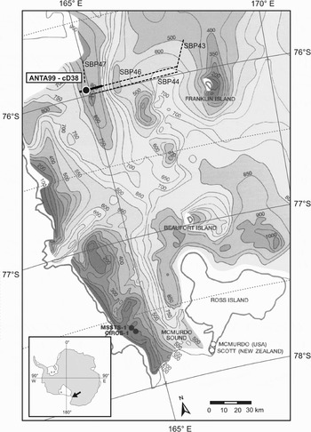
The seismic and sedimentological datasets were acquired during the 1998–1999 PNRA (Programma Nazionale di Ricerche in Antartide) oceanographic cruise. Seismic data, including 240 km of profiles, were obtained using a 3.5 kHz, 200 J GeoAcoustics GeoPulse sub-bottom profiling system (SBP). The core (ANTA99-cD38: 75°57.6′S; 164°54.6′E; water depth: 888 m) was collected with a 2.3 ton gravity corer (internal diameter 90 mm). The location of the 3.5 kHz sub-bottom profiles and the core site are reported in Fig. 1.
Location of core ANTA99-cD38 and SBP lines (dashes). The solid line is the part of the profile shown in Fig. 2. Bathymetry from Davey (Reference Davey1995), redrawn.

The core was analysed for magnetic susceptibility (MS) and X-rayed, then split and described and the data on its physical properties (pocket penetrometer) collected. The core was subsampled (every 10–20 cm) for sedimentological (grain size and water content) and geochemical (organic carbon) analyses. The grain-size analyses were performed using a sedimentation tube (Macrogranometer, length 185 cm, diameter 20 cm) and a Micromeritics 5100 Sedigraph for the muddy fraction. The organic carbon (OC) was analysed with a Perkin Elmer 2400 CHN Analyzer after HCl treatment.
Results
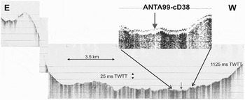
The SBP profiles showed that the basin had a complex seafloor morphology with a draping deposit characterized by undisturbed sedimentation and lack of gravity flows. In particular, fine sediment was preferentially preserved in the deeper areas. In fact, the data showed a thick, continuous sedimentary drape occurring below a water depth of 800 m, as well as at lesser depths in the sector in front of Franklin Island. Seismic stratigraphy (Fig. 2) showed a mean transparent sediment thickness of about 3.5 m two-way travel time (TWTT), overlying a unit that was acoustically opaque to the SBP. The transparent unit showed internal stratification with faint reflections. There were two clear layers, at about 2.9 ms and 3.7 ms below the seafloor, near the core site.
Strike section (western stretch of SBP line 46) showing the deepest part of the Basin and the ANTA99-cD38 core site. See Fig. 1 for the location.

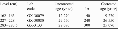
Three horizons (selected on the basis of lithostratigraphic changes) were radiocarbon dated with Accelerator Mass Spectrometry (AMS) at Geochron Laboratories, Massachusetts, USA (Table I). There were no carbonate skeletal remains in this core; consequently the acid insoluble organic matter (AIO) was dated after HCl treatment. The radiometric ages were corrected for a regional correction factor of 3000 yr. This value was chosen following Andrews et al. Reference Andrews, Domack, Cunningham, Leventer, Licht, Jull, DeMaster and Jennings(1999) and Licht (Reference Licht2004) who discussed the factors affecting old radiocarbon ages in core tops collected from the Ross Sea continental shelf and drew the conclusion that there was a geographical distribution in the age of the surface sediments. Most of the ages in the western Ross Sea are in the range 1900 to 3000 yr, whilst values in the central and eastern part are considerably older. Another factor affecting surface age was organic carbon and biogenic silica content: higher percentages resulted in younger top ages. Consequently modern mud with OC values > 1% was more likely to produce reliable radiocarbon ages (Licht & Andrews Reference Licht and Andrews2004).
AMS 14C ages of ANTA99-cD38 core, based on acid insoluble organic matter. Corrected ages by subtraction of 3000 yr (Andrews et al. Reference Andrews, Domack, Cunningham, Leventer, Licht, Jull, DeMaster and Jennings1999, see text).
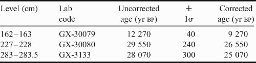
We did not apply the correction factor of 1200–1300 yr suggested by Gordon & Harkness (Reference Gordon and Harkness1992) and Berkmann & Forman Reference Berkman and Forman(1996) for the reservoir effect of the Southern Ocean. This correction factor is estimated from marine shells, penguin remains and seal bones of known ages and is normally used for correcting 14C dates of marine-derived materials (Licht Reference Licht2004, Baroni & Hall Reference Baroni and Hall2004, Hall et al. Reference Hall, Baroni and Denton2004) but cannot be used for bulk organic matter in marine sediments. The uncorrected laboratory ages are listed in Table I.
The two lower dates showed inverted values, with a difference of 1480 yr. This difference was a little more than the variability, estimated as about twice the laboratory standard deviation (Andrews et al. Reference Andrews, Jull and Leventer1997, Reference Andrews, Domack, Cunningham, Leventer, Licht, Jull, DeMaster and Jennings1999) by means of replicate sub-samples from the same horizon. The inversion could have been due to contamination by old carbon (Domack et al. Reference Domack, Jacobson, Shipp and Anderson1999) or a variable reservoir effect through time (Van Beek et al. Reference Van Beek, Reyess, Paterne, Gersonde, van der Loeff and Kuhn2002).
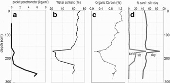
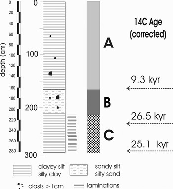
From the core description and preliminary analyses (Fig. 3), three sediment types were distinguished (Fig. 4).
Unit A (0–167 cm), a biosiliceous mud (Fig. 5) with dispersed millimetre to centimetre-sized clasts. The prevailing biogenic content was demonstrated by high organic carbon values that were over 1.0% in the upper 50 cm. Downcore there was a gradual change in colour from olive to olive grey to dark grey.
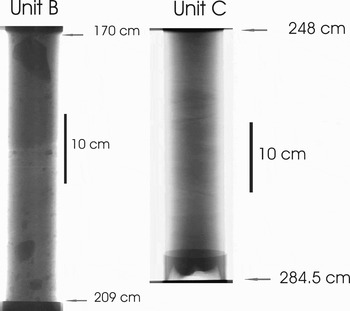
Unit B (167–213 cm), a coarse-grained unit composed of a poorly sorted pebbly sand-silt-clay mixture. Dark colours, ranging from black to dark grey, predominated. Sand percentages were about 18–10%, with a peak up to 50% medium-fine sand at the top of the unit. The X-ray (Fig. 6) showed a faint orientation of the clasts. The organic carbon content was low, with a mean value of 0.39 ± 0.11%.
Unit C (213–295 cm), a biosiliceous mud with a low water content and high compressive strength. The organic carbon was high (0.98 ± 0.05%) and constant, very similar to that of Unit A. Almost the entire unit was highly laminated, with planar and oblique laminae of millimetric thickness. Colours were alternating olive and pale yellow.
Core ANTA99-cD38. Downcore distribution of a. pocket penetrometer data, b. water content, c. organic carbon content, and d. sand-silt-clay ratio.

Core ANTA99-cD38. Lithostratigraphic description, unit identification, and corrected radiocarbon ages.

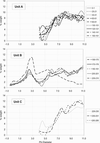
Core ANTA99-cD38. Grain-size frequency curves for each unit.

X-ray (positive) of selected section of core ANTA99-cD38.

Discussion and conclusions
Unit A was a Holocene diatomaceous mud, resulting from modern sedimentation driven by both oceanographic and biological processes. The age of the base unit fitted well with other radiocarbon ages obtained from superficial muddy units of other cores of the western Ross Sea. Just south of the Drygalski Ice Tongue, the onset of open marine conditions is dated back to 9.5–9.9 kyr bp (following Nishimura et al. Reference Nishimura, Nakasone, Hiramatsu and Tanahashi1998, Domack et al. Reference Domack, Jacobson, Shipp and Anderson1999, Cunningham et al. Reference Cunningham, Leventer, Andrews, Jennings and Licht1999).
On the other hand data from raised beaches indicate that the deglaciation of the Victoria Land coast that followed the recession of the Ross Sea ice sheet grounding line, occurred not earlier than 7.2 kyr bp at Terra Nova Bay and 6.6 kyr bp along the southern Scott Coast (Baroni & Hall Reference Baroni and Hall2004, Hall et al. Reference Hall, Baroni and Denton2004).
From its textural features and its stratigraphic position, Unit B is interpreted as a diamicton, suggesting a depositional mechanism strongly related to glacial processes during the LGM. At this stage of the research we are not confident enough to distinguish subglacial from glaciomarine diamicton. However, the internal structure and organic carbon percentages suggest a preliminary glaciomarine interpretation. The coarse sandy level at the top of Unit B is a common stratigraphic feature of diamicton top in the Ross Sea. This unit was first noted by Kellogg et al. (Reference Kellogg, Truesdale and Osterman1979) and, more recently, described by Domack et al. (Reference Domack, Jacobson, Shipp and Anderson1999) as a “muddy gravel and coarse sand unit” that marks the transition between diamicton and overlying muddy lithofacies.
These units have been imaged with SBP as a continuous drape with a thickness of about 3 m along the Basin axis. In particular, assuming a velocity of 1.600 m s-1 and considering gravity core compression of about 10–20%, the 2.9 ms reflection could correspond to the coarser levels of Unit B (about 170 cm). The 3.7 ms reflection still lies just below the bottom of the recovered core and its characteristic cannot be directly determined by sediment analyses.
In short, Units A and B are a frequent sedimentary sequence found in many cores collected from basins on the Ross Sea continental shelf, and describe its sedimentary history from the LGM to the Holocene (Anderson et al. Reference Anderson, Brake and Myers1984, Licht et al. Reference Licht, Jennings, Andrews and Williams1996, Domack & Harris Reference Domack and Harris1998, Brambati et al. Reference Brambati, Corradi, Finocchiaro and Giglio2002).
The sediment of Unit C is also a biogenic mud, overlain by Unit B and, probably, overconsolidated by ice loading during the LGM. We have tentatively referred this unit to Marine Isotope Stage 3 (MIS3) (25.0–56 14C kyr bp, Voelker et al. Reference Voelker2002). The sampling failed to collect the base of Unit C, but from the SBP profiles we can infer a thickness of about 1 m.
Although we must consider some uncertainty in the accuracy of radiocarbon dating of Antarctic marine sediments, C14 radiometric ages from core ANTA99-cD38 suggest the occurrence of open water conditions predating the LGM in this portion of the Ross Sea. If this is correct, the 14C ages and the stratigraphic position of Unit C, would indicate that this sediment was deposited before the advance of the Ross Sea Ice Sheet grounding line to the north of Coulman Island, during the LGM. The date > 28 kyr is in agreement with the end of Stage 3 suggested by several Antarctic ice cores (Petit et al. Reference Petit, Jouzel, Raynaud, Barkov, Barnola, Basile, Bender, Chappelaz, Davis, Delaygue, Delmotte, Kotlyakov, Lipenkov, Lorius, Pepin, Ritz, Saltzman and Stievenard1999, Steig et al. Reference Steig, Morse, Waddington, Stuiver, Grootes, Mayewsi, Twickler and Whitlow2000, EPICA 2004).
Finally, we would like to mention that this core is the first to record MIS3 marine sediments in the Ross Sea. The marine record is supported by pre-LGM dates from raised beach sediments on land, which have recently been found at Cape Ross (Gardner et al. Reference Gardner, Hall and Wehmiller2006) and have also been documented in the Terra Nova Bay area. The geomorphological study of raised marine beach deposits, as well as 14C dating of penguin bones and Nacella fragments, supplemented by amino acid racemization data, indicates storm-beach deposits predating the Holocene.
Gardner et al. (Reference Gardner, Hall and Wehmiller2006) stressed the importance of these results in the reconstruction of relative sea uplift following the LGM. We would like to emphasize that the existence of storm beach deposits implies geomorphological processes involving waves, and consequently open water conditions. In conclusion, we can say that the land and marine data converge in indicating that part of the coast of the Ross Sea, south of the Drygalski Ice Tongue, enjoyed open-marine conditions before the LGM.
Acknowledgements
This work was supported by PNRA (Programma Nazionale di Ricerche in Antartide). The authors wish to thank N. Corradi, G. Fontolan and all the researchers on board RV Italica during the 1998–99 cruise for collecting data and providing useful discussions, J. Pike for comments during preparation of an early version of the manuscript, K.J. Licht and J. Evans for providing constructive reviews, P.K. Nixon for improving the English text. Finally we thank Prof A. Brambati for strongly encouraging the research.