NORTHUMBERLAND
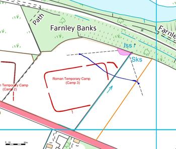
(1) Corbridge, Farnley Grange, West Lodge (NY 99724 63120): a watching-brief was carried out as part of emergency remediation works to a ruptured pipe caused by a landslip on to the Newcastle–Carlisle railway line. Repairs to the damaged section of foul pipe required the excavation of three trenches inside the boundary of Farnley Grange Scheduled Monument.Footnote 41 The area of the Scheduled Monument includes the whole of one Roman temporary camp (Camp 3) and the northern sections of two adjacent camps (Camps 1 and 2). The camps at Farnley Grange are no longer visible as upstanding earthworks as they lie in a heavily ploughed agricultural landscape, but their location and respective dimensions have been extrapolated from previous aerial photographic cropmark analysis (fig. 9).Footnote 42
Farnley Grange, West Lodge. Plan of Roman temporary camps (highlighted in red) and location of archaeologically investigated trenches (highlighted in blue). (© Archaeological Research Services Ltd)

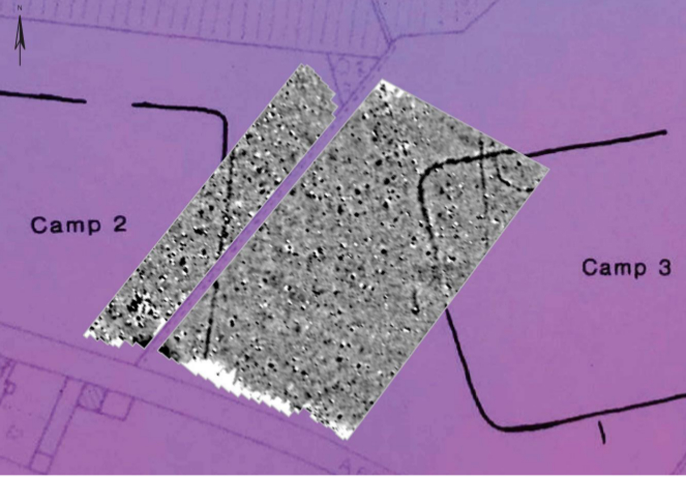
The watching-brief revealed the location of two previously unidentified ditches, F307 and F308, east of Roman Temporary Camp 3. Ditch F308 was considered to be the southerly continuation of an external defensive ditch, identified during aerial photography, which curved around the north-east corner of Camp 3. Ditch F307 similarly respected the orientation of the principal ditches of Camp 3 and was also interpreted as another outwork or defensive embellishment of Roman provenance. Consequently, both features were considered to be representative of an expansion to the original camp layout and potentially indicative of long-term use or reuse of the camp defences. No other finds or features of archaeological significance were identified during the archaeological watching-brief.Footnote 43 However, the interventions monitored by the watching-brief exercise only effected a temporary repair to the ruptured water-pipe situated within the scheduled monument boundary and required a permanent solution which would limit future impact to the monument. Consequently, a phase of geophysical survey was conducted as part of a feasibility study to determine the route of least impact for a permanent diversion of the water-pipe network around the scheduled area.Footnote 44 The geophysical survey identified and accurately located the eastern side of Camp 2 and the north-western corner of Camp 3. The geophysical survey revealed new evidence for a possible defensive outwork, or titulus, associated with the western entrance into Camp 3 as well as a number of archaeological features, probably related to an earlier prehistoric phase of occupation, which appeared to underlie the north-west boundary ditch of Camp 3 (fig. 10).Footnote 45
Farnley Grange, West Lodge. Plan of geophysical survey results with aerial photograph cropmarks overlain, note the possible titulus outside the entrance of Camp 3. (© Archaeological Research Services Ltd)

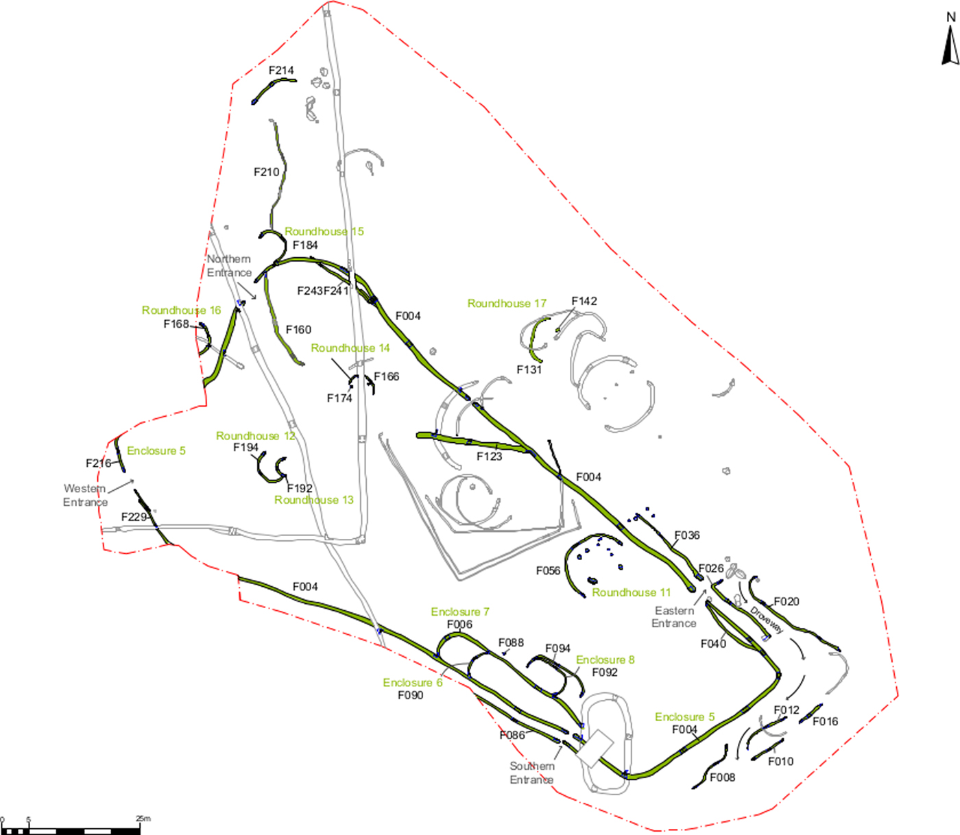
(2) Morpeth, St George's Hospital (NZ 20331 86677): an archaeological excavation of c. 1.28 ha in advance of a housing development was focused on a late prehistoric or Roman Iron Age rectilinear enclosure which had been identified during an earlier phase of geophysical survey and archaeological evaluation trenching. The archaeological material identified during the excavation revealed evidence for multiple phases of activity dating from the Neolithic to the post-medieval periods with concentrated activity occurring during both middle Iron Age and Roman phases of occupation (fig. 11).
St George's Hospital, Morpeth. Plan of Roman Iron Age features (highlighted in green). (© Archaeological Research Services Ltd)

The dating evidence suggested that the middle Iron Age settlement was abandoned by the end of the third century b.c. at the latest. Subsequent re-occupation of the site was later characterised by the establishment of a much larger, irregular rectilinear enclosure during the Roman Iron Age. The enclosure comprised a long ditch circuit punctuated by four entrances which was bordered internally by an upcast bank enclosing an internal area of 0.63 ha. The entrances were identified at the northern, eastern, southern and western extents of the enclosure with what is interpreted as a droveway bordering the principal eastern entrance. The south-western and eastern entrances were also flanked by parallel ditches which were probably banked and intended to aggrandize entry to the enclosure. A single, internal roundhouse structure was identified immediately adjacent to the eastern entrance. The presence of only a single, internal residence coupled with an external droveway and several smaller, internal feed pens suggests that the enclosure functioned as a large compound presumably associated with the keeping of livestock. The earliest radiocarbon date recovered from the enclosure was 19–129 cal a.d., whilst radiocarbon dating from the internal structures produced a date range of 256–413 cal a.d. The long-term occupation and maintenance of the stock enclosure at St George's may, therefore, be confidently assumed to span the Roman Iron Age and contrasts with a wider pattern of farmstead abandonment identifiable within the more southerly Iron Age enclosure settlements at Blagdon Park, East Brunton and West Brunton, which lie 13.7 km south of St George's in what may have been Brigantian territory.Footnote 46 The reuse of the St George's site together with the re-organisation of the late Iron Age farmstead 1.2 km away during the Roman Iron Age suggests that the arrival of the Roman military in the region prompted the reuse/re-organisation of some farmsteads whilst others were abandoned.Footnote 47
(3) Whittington: 19 silver denarii, 1 dupondius and 1 copper-alloy brooch: probably Mark Antony (32–31 b.c.), 1; Vespasian (a.d. 69–79), 5; Domitian Caesar, 1; Titus (a.d. 79–81), 2; Domitian (a.d. 81–96), 1; uncertain Domitian or Nerva, 1 (= dupondius); Trajan (a.d. 98–117), 6; Antoninus Pius (a.d. 138–61); Diva Faustina I, 1; Marcus Aurelius Caesar, 1; Marcus Aurelius (a.d. 161–80), 1 (TRP XVII = a.d. 162–3). The hoard also contained an associated, incomplete trumpet brooch.Footnote 48
NORTH TYNESIDE
(1) Dinnington: 1 gold aureus and 6 silver denarii: aureus: Vitellius (a.d. 69), 1; denarii: Antony (32–31 b.c.), 1; Vespasian (a.d. 69–79), 3; uncertain Flavian (a.d. 69–81), 1; Domitian (a.d. 81–96), 1.Footnote 49
CUMBRIA
(1) Ambleside to Old Penrith, a Roman road through the centre of the Lake District: Pugmire proposed a Roman road over Dunmail Raise between Ambleside and Keswick pre Lidar evidence.Footnote 50 The modern evidence was fragmentary but now Lidar has added more evidence and offered a logical destination.Footnote 51
Heading north from Ambleside fort, the first real indication of a Roman type agger in the Lidar data is across Rothay Park heading NNE (NY 3728 0434). South of this there is a boundary and ditch that could indicate the course of the road back towards the fort. The alignment across Rothay Park indicates the road must have changed direction slightly at the crossing of Stock Ghyll. Beyond the ghyll there is a second length of about 400 m where a straight agger shows a little faintly heading this time NNW (NY 3724 0470). The road probably merges with the modern A593 road at NY 3719 0533.
It would seem possible that much of the modern A591 overlies the road passing Rydal and Grasmere, although the old road between these locations via How Top is more likely. Again, north of Grasmere there are a few short features in the Lidar data but nothing that could be considered certain. The next real clue is on the north side of Dunmail Raise approaching Wythburn and this is the agger that was spotted by Pugmire. Unfortunately, Lidar coverage does not extend over its full length but what does show is typical of a Roman road agger.
The next feature visible in the Lidar data is near Thirlspot Farm (NY 3176 1803) where 600 to 700 m of a straight length of agger is visible.Footnote 52 Projecting this alignment south it would merge with the A591. However, projecting it northwards it is aligned with the B5322 through St John's in the Vale. Supporting this is a short length of agger near Fornside east of the B5322 (NY 3198 2061).
Taken individually these locations probably would not count as concrete evidence for a Roman road. However, collectively they present a much stronger case but perhaps not yet totally convincing unless a connection could be established to another certain length of Roman road and a destination determined.
Lidar revealed a Roman road between Troutbeck and Threlkeld, confirming a suggestion by T.M. Allan,Footnote 53 but west of Threlkeld there was nothing visible. Allan had projected the alignment westwards from the east of Threlkeld through Keswick, but the Lidar provided no supporting evidence for this. The Lidar confirmed the road only as far as Station Road, Threlkeld, but this would allow a turn SSW there, on a course coinciding with the modern road (B5322) into St John's in the Vale. The initial stretch of the modern road into the vale is very straight for around 700 m before another slight turn to almost due south. Through the confines of the vale there is not much scope for variation in the road course so it is reasonable to conclude that the Roman and modern roads would probably coincide for most of this length. However, just south of Mire House the modern road drifts off to one side and a short length of agger is visible on the ground in the adjoining field, west of the B5322 (NY 3161 2365).
The obvious conclusion is that the road from Ambleside, last detected in the southern section of St John's in the Vale, best fits as part of a Roman road from Ambleside to Troutbeck and beyond. From Troutbeck there is the known Roman road to Old Penrith,Footnote 54 which also shows up very clearly in the available Lidar data. The known road from Troutbeck to Old Penrith always seemed to make little sense on its own but when considered as part of a route from Ambleside it is perfectly logical (fig. 12).Footnote 55
Central Cumbria showing the route of the road from Ambleside to Old Penrith via Troutbeck. (OS OpenData mapping - Contains OS data © Crown copyright)

(2) Eskdale, Roman road from Ravenglass into Eskdale: seventy years on from Richmond's work on the course of this road his conclusions still stand.Footnote 56 However the two extremities of the road, west from Ambleside and east from Ravenglass eluded him. Recently, as part of the ‘Romans in Ravenglass’ project, the road in the vicinity of Ravenglass fort was found.Footnote 57 Lidar also shows this clearly and has revealed the probable course of the road up Eskdale to within about two miles of Hardknott fort, where the Lidar coverage ends.
Prior to the ‘Romans in Ravenglass’ project, it was generally believed that this road emanated from the fort's east gate. The project found that it actually lay around 150 m north of the fort. In addition, Lidar indicates that there was possibly another road branching from this one towards the bath-house and fort (fig. 13). The route from the fort environs is very clear and again across Muncaster Chase (SD 1030 9685).
Lidar image showing the course of the Roman road from Ravenglass to Ambleside heading into Eskdale. The alignment of the road is well north of the fort rather than heading for its east gate. A possible branch road is visible running towards the bath-house (dotted). (© The Environment Agency)

From Muncaster Chase the road largely follows the modern track/footpath with just a few deviations such as at Birks Coppice (SD 1281 9848). This course passes the site of the Muncaster kilns. It finally leaves the track just west of Muncaster Head and crosses Forge Hills (SD 1432 9931). Here movements of the river Esk over the centuries have changed the landscape. The river has formed a wide meander which has eroded much of the river bank taking all traces of the road with it.
Beyond the eroded section east of Forge Hills, the agger reappears in the Lidar data near The Green (SD 1482 9972). It joins the modern road at SD 1499 9986 and from here eastwards there are no visible deviations away from this road all the way to where the Lidar coverage ends near the Woolpack Inn. It is more than likely therefore that the modern road here follows its Roman predecessor just as Richmond surmised 70 years ago.Footnote 58
(3) Kirkbride fort, p ossible western extremity of the fort (NY 2295 5732): Kirkbride is a difficult site and it appears from the Lidar data as if there has been much activity after the construction of the initial fort. This confuses the situation and makes interpretation very difficult as most of the visible features seem unrelated to the fort as recorded by Richardson and Bellhouse.Footnote 59 Overlaying their plan on the Lidar data, a best fit allowed the probable north-western corner of the fort to be identified (fig. 14).
Lidar image of Kirkbride Roman fort with Richardson and Bellhouse's (1982) fort plan overlain. The possible north-west corner of the fort is visible as is a probable Roman road. (© The Environment Agency)

Its orientation would fit well but was further west than Richardson and Bellhouse had surmised. They had thought the fort's west rampart must have been ‘obliterated’ by the church but this Lidar evidence shows it could well have been further west. This would make the fort considerably larger — around 190 m east–west over the ramparts.
Bellhouse's excavated east ditch of the fort also shows in the Lidar image, albeit very faintly. No trace of the southern side of the fort was discernible.Footnote 60
(4) Netherby (Castra Exploratorum), Netherby Hall (NY 3965 7163): the fort, which is known to lie approximately beneath Netherby Hall, was, according to antiquarian accounts, accompanied by a bath-house, a temple, a sizeable civilian settlement and perhaps wharves on the bank of the river Esk, with inscriptions and other finds suggesting that occupation of the site spanned at least the late first to mid-third centuries. However, twentieth-century investigators concluded that no surface remains survived to indicate the exact form and extent of the fort, leaving the location and condition of the other features even more insecurely understood. In 2014, in response to a request from the new owner of Netherby Hall, a series of trial-trenches were excavated around the northern end of the stable block.Footnote 61 One of these revealed a military ditch, containing Roman pottery. In 2015, follow-up analytical field surveyFootnote 62 demonstrated that sections of one or perhaps two defensive perimeters can be traced as degraded earthworks, mostly surviving within the ornamental woodland of the Hall's eighteenth-century designed landscape. The better-defined features suggest that, despite the sophistication implied by antiquarian descriptions, the military base itself was, presumably at a relatively late date in its use, a fortlet of only c. 0.3 ha, probably square in plan. Lidar imagery, in conjunction with analysis of historic maps and rapid field survey, has allowed identification of the probable site of the bath-house, which was carefully recorded when exposed by stone robbers in 1732, but then lost, even though its site was mapped by General Roy in the 1750s. A few other features of potentially Roman date were identified. Fluxgate gradiometry and electrical resistance surveys were also carried out on the site of the fort and elsewhere, but unfortunately the results did not provide clear evidence for features of Roman date.Footnote 63
(5) Netherby area, Roman roads in the vicinity of Netherby, near Longtown: most maps of Roman roads, including the Ordnance Survey Roman Britain map,Footnote 64 show Netherby at the end of a spur off the main road to Scotland via Birrens. In addition, the course of the road approaching Netherby was somewhat doubtful. However, the Lidar data have shown not just the Roman road approaching Netherby but it continuing northwards to the Scottish border where it appeared to fork — one branch heading north-west towards Broomholm and a second probably continuing up Liddesdale on its northern bank.
The agger of the road approaching Netherby from the south is extremely clear diverging from the modern road at Crofthead (NY 3852 7017) just north of Longtown. It makes a slight turn about halfway across Netherby Park (NY 3906 7104) to begin its approach to what must be the location of the fort, although the exact location remains unknown (fig. 15).
The Roman roads south and north of the site of Netherby fort. North of Liddel Water there are signs that the road forked with one branch heading up Eskdale and the other heading up Liddesdale. (OS OpenData mapping - Contains OS data © Crown copyright)

The road reappears again north of the fort site near Red Bank (NY 4011 7300) heading towards Riddings Farm. This course takes it just to the east of the site of Liddel Strength motte and bailey (NY 4090 7449). Beyond Riddings Farm the Lidar evidence is somewhat patchy but the road is clearly making for a crossing of Liddel Water just west of Liddel Viaduct on the disused railway (NY 4090 7549).
After crossing the river, now in Scotland, there are clear indications of two probable routes. One is heading up Eskdale passing the Roman camp near Claygate with Broomholm fort its likely objective. The second road appears to continue up Liddesdale (NY 4166 7673) to an unknown destination.Footnote 65
Just south of Longtown, Lidar also shows clearly the road from Birrens heading to Roost Ford (NY 3667 6676) as surmised by Margary.Footnote 66 He thought it would have been destroyed by the MOD munitions site but surprisingly its course is still traceable as far as Springfield (NY 3346 6796).Footnote 67
(6) Old Carlisle to Kirkbride Roman road: Margary postulated that the very direct modern road via Oulton could represent its course, i.e. a route on the west side of the river Wampool.Footnote 68 However Lidar revealed that there was indeed a Roman road linking the two forts but that it crosses onto the east side of the river.
The route is in two alignments with a change of direction around the half-way point just north of Moorside, in the vicinity of NY 261 517. The first (southern) alignment begins outside the east gate of the Old Carlisle fort and heads over Highmoor in a northerly direction. The Lidar evidence is then somewhat fragmentary passing Wigton. Its course here is a little subjective and a route via Stony Banks is one possibility.
Beyond Wigton there is a particularly prominent agger visible in the Lidar data (NY 2587 4983) heading towards Moorside and parts of the modern road to Moorside probably overlie it here. After the crest at Moorside the second (northern) alignment begins.
By contrast this stretch is remarkably clear and certain. It is almost a single alignment all the way to the fort with only the slightest of deviations just to the west of Biglands. This shows up especially clearly in the oblique Lidar image and was perhaps to negotiate the small hill there (fig. 16).
Oblique Lidar image showing the agger of the Roman road from Old Carlisle to Kirkbride from the first crossing of the river Wampool towards Kirkbride fort. (© The Environment Agency)

There are some indications that the road could have continued to Bowness, including a possible road passing the north-west corner of Kirkbride fort (fig. 14) and again just to the east of Whitrigg House there are signs of an agger (NY 2311 5829). However, beyond Whitrigg House the modern road would probably overlie it.Footnote 69
(7) Sedbergh, Burrow to Low Borrowbridge Roman road in the vicinity of the river Rawthey: the Roman road from Burrow in Lunedale (or Lonsdale) to Low Borrowbridge is well attestedFootnote 70 apart from a small section to the west of Sedbergh across the valley of the river Rawthey. Lidar has now provided some clear indications as to its probable course (fig. 17). The first stretch visible is west of Jordan Lane centred on SD 6341 9013. Here Jordan Lane was obviously moved off the Roman line to accommodate the building of the railway.
The probable course of the Roman road west of Sedbergh revealed using Lidar. (OS OpenData mapping - Contains OS data © Crown copyright)

North of the river Rawthey, east of Hebblethwaites, a length of agger is visible (SD 6370 9146) which matches the Jordan Lane alignment. The final stretch visible is north of the A684 and extends the previous alignment before making a slight turn to the north. It is centred on SD 6380 9215.Footnote 71
(8) Temple Sowerby, Kirkby Thore to Brougham and Kirkby Thore to Old Penrith Roman roads: the road from Kirkby Thore to Brougham is well recorded but when a milestone was discovered at LangwathbyFootnote 72 the likelihood of a direct road to Old Penrith bypassing Brougham became almost certain. This would be in all probability the route of Antonine Itinerary Iter II but its course was unknown. A search of the Lidar data on the west side of the river Eden near Temple Sowerby revealed not the anticipated branch road off the (known) road to Brougham but a crossroads (NY 5971 2859). Site visits and further inspection of the Lidar data indicated a triangular (hypotenuse) road bypassing the crossroads on its north-eastern side which almost certainly was the start of a previously unknown road to Old Penrith. In addition, there were clear signs of a second road through Temple Sowerby (NY 6139 2690) and two crossings of the river Eden (fig. 18).
The complex of Roman roads revealed by Lidar near Temple Sowerby. The chronology is best explained by the northern crossing of the river Eden being the first with the southern one a later development, possibly for a bridge. Note this map predates Temple Sowerby bypass. (OS OpenData mapping - Contains OS data © Crown copyright)

Both the road to Brougham and that of the newly discovered one to Old Penrith were clearly set out from the northern crossing, which must therefore have been the earlier of the two. The later southern crossing is located at an ideal bridging point where sandstone outcrops. The route and direction from the southern crossing up to the Brougham road and on to the Old Penrith road is the shortest practical route to join up with roads from the earlier northern crossing. This would mean that the ‘crossroads’ never actually functioned as such but reflects the existence of two phases or roads.
The route of the Old Penrith road from the northern crossing using the ‘hypotenuse’ road links up in a direct line with two pieces of Lidar-derived evidence (NY 5880 2955 and NY 5797 3006) and heads undoubtedly to Udford on the river Eamont. North of the river Eamont this alignment continues up Udford road. This road has all the classic hallmarks of a Roman road and it is surprising this has not been considered as Roman before. Beyond the Udford road there is no Lidar data but the Antonine Itinerary Iter II gives a distance of 13 (Roman) miles for Kirkby Thore to Old Penrith. This distance fits perfectly if this alignment continued reasonably directly.Footnote 73
COUNTY DURHAM
(1) Binchester (Vinovia) (NZ 2102 3134): a follow-on project to the major excavation of 2009–15 saw the investigation of an area to the rear of the mausolea discovered by Time Team in 2007.Footnote 74 The excavation, located approximately 100 m ESE of the east corner of the fort sampled part of a ditched enclosure within which thirteen inhumation burials were investigated. The majority were simple cut graves. One produced a fragment of a late Roman gold and garnet necklace while another included a horse's head. Initial appraisal of the dating evidence suggests this part of the cemetery was in use in the fourth century. Further work is planned for 2017.Footnote 75
(2) Chester-le-Street (Concangis), Lindisfarne Avenue (NZ 2763 5114): continued investigations in the gardens of properties on the east side of Lindisfarne Avenue revealed further details of the regimental bath-building including a doorway giving access from what was probably the frigidarium via a short flight of steps down to a possible exercise-yard (palaestra). A plan of the remains of hypocausted chambers uncovered in 1856 to the south of the current investigations and long thought to have been lost was reported by Mr George Muirhead as being lodged in the Northumberland County Records Office from which copies were obtained.Footnote 76
(3) Layton: 18 silver denarii: Domitian (a.d. 81–96), 2; Trajan (a.d. 98–117), 3; Hadrian (a.d. 117–38), 3; Sabina, 1; Antoninus Pius (a.d. 138–61), 1; emperor illegible, 8.Footnote 77
(4) West Chilton (NZ 2860 3064): excavations in advance of housing development uncovered the remains of a Romano-British settlement covering an area of at least 7 ha. Trackways separated ditched enclosures some of which contained timber roundhouses and their stone replacements. Pottery ranged in date from the late Iron Age to the second century a.d. A notable aspect of the work was the recovery of no less than thirteen quernstones and nine larger millstones raising the possibility that the inhabitants of the settlement were engaged in intensive cereal farming and processing (for the military market?).Footnote 78
NORTH YORKSHIRE
(1) Aldborough (Isurium Brigantum) (SE 4045 6640): as part of the continuing programme of research into the Roman town,Footnote 79 a 5 by 2 m hand-dug trench was opened over part of a courtyard building investigated by Eckroyd Smith in the nineteenth century which contained the mosaics currently displayed by English Heritage.Footnote 80 The trench was located to intersect three rooms recorded by Eckroyd Smith whose plan was shown to be remarkably accurate.
Three walls were revealed (fig. 19): Wall 1 running east–west, dividing Room 1 from Room 2. There was not space to fully excavate Room 1, so the levels in this area remain in the Victorian backfill layer. On the north side of Wall 1 the masonry is more visible, and shows evidence of the floor level: the footings extend 0.03–0.04 m from the upper levels and a layer of mortar was present. The southern face of the wall shows evidence for a series of vertical recesses as indicated on the Eckroyd Smith plan.Footnote 81 Although not excavated, these clearly represent vertical flues designed to carry hot air up the inner face of the walls. Wall 2 runs north of and parallel to Wall 1 and was bonded with Wall 3 which runs north–south through the trench and is clearly contemporaneous. Wall 3 is characterised by two openings below floor level that form part of a channelled hypocaust within Room 2.
Aldborough. Trench viewed from the south-west looking north-east showing excavated walls.

In the broader context of the Eckroyd Smith plan and the ground penetrating radar results in this area, these structures and rooms can now be interpreted in more detail. They form the north-west corner of a large town-house. Eckroyd Smith's plan shows the north-west corner of a large courtyard surrounded by a portico which appears to have fronted onto the principal north–south street of the Roman town (modern day Front Street).Footnote 82
(2) Aldborough (Isurium Brigantum), Museum House, Front Street (SE 4048 6616): the monitoring of the machine excavated foundations recorded a single large ‘foundation’ pad built from irregularly shaped pieces of stone set directly on top of the underlying natural geology. The pad was formed from two layers of stone, a lower one of local, coarse red sandstone and an upper one of large sandstone blocks. No other associated features could be seen within the limits of the foundation trench, although the backfill of the earlier sewage trench nearby did contain some redeposited red sandstone blocks some of which had lime mortar on one surface. Two small body sherds of Roman greyware and a fragment of tegula were recovered from the topsoil during the monitoring. Although there were no other features observed in association with the pad, it is assumed that it was the stone base to support a large post for a building. However, its location in relation to, and just outside of, the Roman town wall is puzzling.Footnote 83
(3) Catterton: 24 silver siliquae: a.d. 355–60, 5 (1 Lyon, 4 Arles); a.d. 360–3, 9 (2 Lyon, 6 Arles, 1 uncertain); a.d. 364–7, 7 (2 Rome, 3 Lyon, 1 Antioch, 1 uncertain); a.d. 367–75, 3 (Trier).Footnote 84
(4) Little Smeaton: 7 silver siliquae: Constantius II (a.d. 337–61), 3 (2 Lyon, 1 Arles); Julian Augustus (a.d. 360–3), 4 (1 Trier, 2 Lyon, 1 Arles).Footnote 85
(5) Norton-on-Derwent, Brooklyn House (SE 7930 7086): as part of a phased investigation of the site an open-area excavation was undertaken on some 1,400 square metres. This was a follow up to an earlier evaluation and geophysical survey which had recorded the remains of a small Romano-British field-system. The 2016 excavation and subsequent watching-brief investigated the remains of c. 10 robbed-out stone buildings, a Roman road and a potential mausoleum. Whilst the role of the majority of the buildings awaits the analysis of the finds assemblage, one of the buildings was found to contain a stone-built flue and was probably used for either malting or corn-drying. The watching-brief recorded the remains of six of the stone buildings orientated gable end onto the adjacent Roman road,Footnote 86 a section of which was also excavated and appears to have had a central ‘lane divider’ running along its mid-line. Initial assessment of the buildings indicates that many of them had been built on a large scale with well-constructed stepped stone foundations. The walls survived up to five courses high and to within 0.25 m of modern ground level. Some of these buildings are currently thought to have been warehouses, possibly with shops facing onto the adjacent road. So far it has only been possible to excavate one whole building which was 14 m long and 5 m wide (fig. 20). The remains of the other buildings encountered suggest that one of them was probably around 8 m wide.
Norton-on-Derwent, Brooklyn House. 14 by 5 m building under excavation, looking north-east.

In addition to the buildings the most striking feature of the site was the vast amount of pottery and animal bone recovered. To date there are approximately 20,000 sherds of pottery with an equally large amount of well-preserved animal bone. This huge amount of material appears to have come from a mid- to late fourth-century rubbish dump that had spread over the stone buildings, which in turn currently appear to have been built over at least part of a second-century cemetery.Footnote 87
(6) Overton: 37 silver/base silver denarii: Domitian Caesar under Vespasian (a.d. 69–79), 1; Titus (a.d. 79–81), 1; Domitian (a.d. 81–96), 1; Trajan (a.d. 98–117), 3; Hadrian (a.d. 117–38), 4; Antoninus Pius (a.d. 138–61), 3; Diva Faustina I, 4; Marcus Aurelius (a.d. 161–80), 1; Divus Antoninus, 1; Lucilla, 3; Commodus (a.d. 180–93), 3; Septimius Severus (Wars of the Succession a.d. 193–7), 1; Caracalla Caesar, 1; Clodius Albinus Caesar, 1; Septimius Severus (joint reign), 5; Caracalla (joint reign), 2; Julia Domna, 2. 37 fragments of Nene Valley ware pottery were recovered with the coins.Footnote 88
EAST RIDING OF YORKSHIRE
(1) Beverley: 100 radiates: Gallienus and Salonina (a.d. 260–8), 15; Claudius II (a.d. 269–70), 12; Quintillus (a.d. 270), 1; Postumus (a.d. 260–9), 3; Victorinus (a.d. 269–71), 16; Tetricus I and II (a.d. 271–4), 47; irregular, 2; uncertain, 4.Footnote 89
(2) Garton: 16 silver denarii: Republic, 2; Antony (32–31 b.c.), 1; Tiberius (a.d. 14–37), 1; Vitellius (a.d. 69), 1; Vespasian (a.d. 69–79), 7; Domitian Caesar, 1; Titus (a.d. 79–81), 2; uncertain Flavian, 1.Footnote 90
WAKEFIELD
(1) North Elmsall: 9 sestertii and 1 dupondius/as. Sestertii: Trajan (a.d. 98–117), 6; Hadrian (a.d. 117–38), 2; emperor illegible, 1. Dupondius/as: Hadrian (a.d. 117–38), 1.Footnote 91
BARNSLEY
(1) Dearne South: 4 silver denarii: Domitian (a.d. 81–96), 1; Trajan (a.d. 98–117), 1; Hadrian (a.d. 117–38), 1; Marcus Aurelius (a.d. 161–80), 1.Footnote 92
(2) Worsbrough: 3 silver denarii: Nerva (a.d. 96–8), 1; Hadrian (a.d. 117–38), 2. Perhaps a dozen more denarii were recovered over some years but as they came up so sporadically the finder did not realise they were part of a hoard and they were not kept. Another finder recovered a denarius of Sabina on the same spot, but likewise did not retain it.Footnote 93
DONCASTER
(1) Doncaster, Rossington Inland Port Borrow Pit 2 (SK 58600 99200): a watching-brief recorded further information regarding a known late Iron Age to Romano-British field-system.Footnote 94 Four ditches were investigated but no datable artefacts were retrieved, though a fragment of heron bone was recovered. A piece of waterlogged roundwood recovered from a basal fill returned a radiocarbon date of 60 cal b.c.–a.d. 70 cal.Footnote 95 The ditches were proven to be contemporary, suggesting a system of planned land division. Palaeo-environmental remains suggest a waterlogged grassland environment with woody scrub nearby suggesting a pastoral economy.Footnote 96
(2) Doncaster Common: 8 silver denarii: Mark Antony (32–31 b.c.), 1; Vespasian (a.d. 69–79), 1; Trajan (a.d. 98–117), 1; Hadrian (a.d. 117–38), 3; Antoninus Pius (a.d. 138–61) for Faustina II, 2; Marcus Aurelius (a.d. 161–80) for Faustina II (d. a.d. 176), 2. Total now stands at 404 denarii to a.d. 176 and 24 sherds of their Roman coarseware pottery container.Footnote 97
(3) Scawsby, land off Barnsley Road (SE 52860 05560): 44 trial-trenches targeting geophysical anomalies were excavated across 16 ha of land, ahead of the construction of a new motorway service station. The presence of field ditches confined to freely draining limestone areas and absent from wetter, more clayey ground was demonstrated. The finds assemblage consisted largely of animal bone, with a single sherd of pottery of probable later prehistoric date. Based on the field-system's form and the regional context, a late Iron Age to Romano-British date is considered likely. Sparse palaeo-environmental remains suggest arable agricultural activity.Footnote 98
(4) Tickhill I: 5 silver denarii: Domitian (a.d. 81–96), 1; Hadrian (a.d. 117–38), 4. The original find was one denarius of Commodus (a.d. 180–92) for Crispina, and one illegible sestertius of an Antonine empress (c. a.d. 138–82), and a copper-alloy (‘bow and fantail’ type) brooch.Footnote 99
(5) Tickhill II: 1 copper-alloy radiate and 5 copper-alloy nummi: radiate: Victorinus (a.d. 269–71), 1; nummi: a.d. 318–24, 1 (mint illegible); a.d. 335–7, 1 (Trier); a.d. 348–54, 3 (2 mints illegible, 1 irregular).Footnote 100
(6) Tickhill III: 1 barbarous radiate and 55 copper-alloy nummi (+ 1 stray nummus). Nummi: a.d. 323–4 Vot X/XX within wreath, 1 (mint uncertain); a.d. 330–5 Gloria Exercitus (2 standards), 53 (24 Trier; 5 Lyon; 3 Arles; 21 uncertain); a.d. 335–7 Gloria Exercitus (1 standard), 1 (Lyon). Stray nummus of a.d. 348–54 (fallen horseman type) in very worn condition recovered from same findspot.Footnote 101
SHEFFIELD
(1) Whirlow Hall Farm (SK 3123 8318): further work added significant new information.Footnote 102 An extension to the geophysical survey identified the site of a probable Roman signal station. These anomalies were subsequently tested by evaluation trenching. Charred wood dating samples from each of the two timber construction slots produced virtually identical radiocarbon determinations that date the site to the late first to early second centuries a.d. It has a square shape with an entrance on its eastern side. The construction slots are interpreted as the foundations for a timber-framed box rampart. An arcing linear ditch anomaly appears to run below the signal station and this is thought to relate to earlier, probable Iron Age, farming activity. The site commands exceptional vistas with a direct line of sight eastwards to the Roman fort at Templeborough which lay on the south side of the river Don and south of the extensive linear earthworks collectively known as the ‘Roman Ridge’ which link the marshlands of the Humberhead Levels with the river Don in the centre of Sheffield. Taken together a case can now be made for the pre-Flavian Roman frontier following the Don as far as Sheffield where it then follows its main tributary, the Sheaf, all the way to its own well-defined tributary known as the Limb Brook, before possibly extending via Navio (Brough-on-Noe) across the Pennines to the Cheshire Plain.
The excavations at the rectilinear enclosure, or estate centre, which also lies on the northern side of the Limb Valley frontier 1 km south-east of the signal station, produced further information on the phasing and dating of the occupation of this site. The site appears to be mid- to late Iron Age in origin before being levelled and rebuilt in a Roman style in the late first century to early second century a.d. and being occupied into the late third century to early fourth century. Evidence for metal-working was discovered on the site allowing for the suggestion that the site may have had a role as a processing site for lead and other minerals leaving the Peak District on their way to export from the riverine fort at Templeborough. A rich ceramic assemblage was recovered from the site together with a stone column base, quernstones and glass fragments. Other features included pits, post-holes and the foundations of a stone-founded rectangular building (fig. 21).
Whirlow Hall Farm. Aerial view of the 2016 excavations on the rectilinear enclosure with the west entrance causeway under excavation by the 2 m ranging pole and the stone wall of a stone-founded rectangular building visible centre left. (© Archaeological Research Services Ltd)

Both sites appear to have been constructed during the Flavian period which suggests that during the pre-Flavian period they both lay on the north, Brigantian, side of the frontier. The estate centre may provide an important window onto the impact of the Roman military on the Brigantian peoples living in the frontier zone and the way in which Brigantia was absorbed into the Roman Empire.Footnote 103
LANCASHIRE
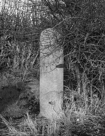
(1) Garstang–Lancaster, Walton-le-Dale to Lancaster Roman road: further work has allowed the route of the road from Garstang to Lancaster to be identified.Footnote 104 It had long been suspected that Fowler Hill Lane at Cabus, north of Garstang, marked the road's course and Lidar has confirmed this. The determination of the route from Garstang to this point led to the realisation that the west gate-post of the Turnpike Cottage at Cabus (SD 4907 4668) was in fact a Roman milestone. It is of typical format with a square base and cylindrical top (fig. 22).
Walton-le-Dale to Lancaster Roman road. The probable Roman milestone at Cabus, opposite Turnpike Cottage.

At Cabus crossroads the agger becomes visible both on the ground and in Lidar imagery (SD 4845 4831). Beyond the canal, Kiln Trees Lane marks the approximate course but this has been so worn away by traffic over the centuries that it is now a hollow way.
Lidar shows the line of the road crossing Forton Hall Farm and road foundation stones are clearly visible in the hedge bottom (SD 4771 5022). There is faint Lidar evidence that the route headed towards the river Cocker bridge and onto Main Street, Cockerham (fig. 23).
Walton-le-Dale to Lancaster Roman road. Oblique Lidar image of the route of the Roman road from Cabus crossroads via Cockerham to Lancaster. A probable Roman milestone was found at Forton Hall and has been re-erected at Forton crossroads about 200 m from the line of the Roman road. (© The Environment Agency)

The line through Cockerham is more than likely overlaid by the modern road so proof is difficult. Projecting the alignment discovered south from Lancaster (see later) would indicate that the Roman road must turn off the modern road and head for Lancaster somewhere near Broad Gate — perhaps a significant name. However, about 300 m to the east of Main Street is a glacial striation running north–south which could have provided an alternative route here. On balance though the modern road through Cockerham seems the much more likely route and would perhaps have given a connection with the sea in Roman times.
After the turn for Lancaster, possibly just south of Broad Gate (SD 4636 5316), then the next visible agger is in the woods at Thurnham Roman Catholic Church (SD 4661 5433). It is in remarkable condition, around 7 m wide and 0.75 m high in the centre. There are more intermittent traces through the woods and where the road exits there is a visible spread of stones confirming the line. When the Glasson Dock Canal was constructed the river Conder was diverted into a straight new course and either side of its channel is evidence of the stones from the road having been piled up on each bank. The old river meander is also discernible in the Lidar plot and is most likely where the Roman bridge would have been (SD 4671 5487).
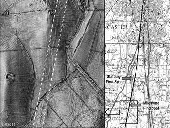
The evidence for the Ashton section is extremely strong. The Lidar image (fig. 24) shows the road very clearly and is convincing enough on its own. In addition, in the field ‘adjoining the canal’ at Ashton was found a milestone dedicated to the emperor Philippus.Footnote 105 This recorded a distance of 3 MP (mille passum), obviously from Lancaster. This fits this route for the road but not that of the previously assumed route east of Burrow Heights. In addition, just north of this spot, when excavating the canal in 1794, the collection of sculptured stones from a probable mausoleum was unearthed.Footnote 106 The findspot was given as in the pasture ‘… on the east side of the canal and the south side of the lane leading from Broken Back Bridge’. The road alignment passes through the findspot field.
Walton-le-Dale to Lancaster Roman road. Left: Lidar image of the Roman road at Ashton. Right: map showing the probable route of the Roman road into Lancaster and its position relative to the milestone and statuary findspots. (Lidar: © The Environment Agency; Map: OS OpenData mapping - Contains OS data © Crown copyright)

Heading into Lancaster the remains of the road have been found at the Royal Lancaster Infirmary and the line is not to the fort but along Penny Street and Cheapside. This was confirmed in 2005 with the discovery of the road on a development site just north of the canal at Aldcliffe.Footnote 107
(2) Kellbrook: 8 silver denarii: Vitellius (a.d. 69), 2; Vespasian (a.d. 69–79), 1; Domitian (a.d. 81–96), 2; Trajan (a.d. 98–117), 2; Diva Faustina I under Antoninus Pius (a.d. 141–61), 1. A ninth silver coin from the findspot was also submitted, but as a clipped siliqua (late fourth century) is likely stray to the denarius hoard.Footnote 108
CHESHIRE
(1) Wrenbury, land at Cholmondley Road (SJ 59016 47726): a metal-detecting survey over 8.8 ha found a bow brooch dating to the first to second centuries a.d. A Romano-British settlement is known within 150 m from the findspot.Footnote 109
NORTH LINCOLNSHIRE
(1) East Halton and North Killingholme, Able Humber Port (TA 1512 2013; TA 1635 1886; TA 1700 1734; TA 1590 1945): over the course of three years Allen Archaeology undertook a series of evaluations and large-scale excavations in an area along the southern bank of the Humber Estuary as a condition of planning consent for the construction of manufacturing and logistics facilities to support the offshore wind industry.
The work commenced in 2012 with a programme of evaluation trenching, auger survey, fieldwalking and earthwork survey. A second phase of work comprised open area excavations, further evaluation trenching, test-pitting and photographic survey of structures associated with a World War 2 barrage balloon complex.
An area totalling 12 ha, across 11 sites, was stripped and hand excavated to reveal a series of small, isolated middle Iron Age enclosures followed by a more complex pattern of late Iron Age enclosures and open settlements that extended across a large area of the Humber foreshore. Many of the large earthworks constructed during the later Iron Age were later used to form part of an extensive Romano-British field-system. This was associated with much larger, estate-like settlements that included aisled buildings, grain stores, metal-working areas and much more. Tens of thousands of pottery sherds were recovered together with a late Iron Age sword, a rare early Romano-British oak ladder and many finely detailed objects such as carved bone, coins and glass bangles.Footnote 110
LINCOLNSHIRE
(1) Baston, Chesham Drive (TF 1164 1373): located adjacent to a known Iron Age field-system an evaluation revealed the continuation of an Iron Age boundary ditch previously known from work to the west, the top fills of which produced Roman pottery, including fragments of later second- to third-century date. A single ditch excavated to the east of this feature also produced Roman material, perhaps suggesting a shift of occupation to the eastern half of the site during the Roman period.Footnote 111
(2) Bourne, St Peter's Road (TF 0934 2002): a programme of archaeological monitoring and recording was undertaken during the construction of a new dwelling. The site lay immediately adjacent to the medieval earthwork remains of Bourne Castle. A single fragment of Roman greyware was recovered, although the piece was residual.Footnote 112
(3) Grantham, Gonerby Moor (SK 8864 4102): archaeological evaluation revealed features of prehistoric date and two ditches dated to the Roman period, one of which produced pottery probably dating to the mid- to late first century a.d. A further ten ditches and two pits remain undated due to lack of artefactual evidence.Footnote 113
(4) Grantham, Spittlegate Level (SK 9242 3349): a scheme of archaeological monitoring and recording was undertaken during water mains replacement work in advance of the construction of the Grantham Southern Relief Road. The site lay near to the small Roman town at Saltersford. The monitoring revealed a single north–south-aligned ditch which produced pottery dating to the second century a.d.Footnote 114
(5) Horncastle, Churchill Avenue (TF 2592 6880): an open area archaeological excavation was carried out within an area of known archaeological remains on the outskirts of Horncastle, a short distance to the south of the Roman town.
The investigation revealed a densely packed network of linear ditches, trackways and enclosures. The features are most likely connected to agricultural activity, including both arable cultivation and animal husbandry. Whilst there is no direct evidence of settlement on the site, there is some evidence of low-level industrial activity, with hammerscale, iron slag and lead melt noted within some of the environmental samples. A large assemblage of Roman period finds was recovered including pottery, brick and roofing-tile, coins, metalwork, human and animal bone, glass and quernstones.
Three broad phases of occupation have been identified, dating from the late first century a.d. to the later fourth or early fifth century.
Phase 1: during the early Roman period, late first to early/mid-second century, the site appears to have been used as farmland with the landscape characterised by a pattern of small fields and paddocks. The nature of occupation during this early phase is not well understood, but the presence of a small quantity of high-status pottery types may indicate a connection with the Roman military or Romano-British elites.
Phase 2: around the middle of the second century, the network of enclosures and gullies seems to have been replaced by a system of larger fields and tracks. Two isolated inhumations of this date were revealed towards the north and east sides of the excavation area.
Phase 3: subsequently, possibly after a short period of abandonment, the third phase of occupation, from the later third to later fourth or early fifth century, saw an intensification of activity on the site. During this phase the system of trackways between the fields was still in use, with earlier lines now well-defined with ditches and one area receiving a metalled surface. There was also extensive recutting of the ditches previously in use during Phase 2, as well as a broad expansion of the ditch system. This final phase also included two lime kilns, possibly suggesting the land was used for crops, with the lime used to improve the land. The purpose of a series of enclosures recorded within this phase is uncertain, although they are presumed to be related to agricultural management activity, perhaps related to animal husbandry. Pottery and coin evidence suggests intensive activity on the site well into the later fourth century and possibly beyond. A notable quantity of the latest pottery from this phase is likely to have been produced in Lincoln indicating the city was a major source of supply up until the end of the Roman period.Footnote 115
(6) Lea, land off Gainsborough Road (SK 8330 8619): an archaeological evaluation in advance of a proposed residential development on a site where geophysical survey had identified a number of possible linear features and enclosures. Twelve 50 m trenches were targeted on areas of potential archaeological interest identified by the geophysical survey. Seven of the trenches were devoid of archaeological features. The remaining trenches identified a small number of linear features, some of which produced a small assemblage of locally produced Roman pottery. This activity was focused around Trenches 3 and 4 towards the western side of the site. The earliest activity comprised a ditch producing a small group of Roman pottery in Trench 3. Two other ditches in this trench, although undated, may be contemporary, given their shared alignment, profile and fills. The Roman pottery assemblage was very similar in appearance to the products of nearby kilns known at Lea and Knaith. The generally low density of finds recovered from the features suggests they were likely to be boundary features for fields or stock enclosures. A further complex of ditches was recorded in Trench 4, although these were largely undated, with one ditch containing a single sherd of Roman pottery, which is insufficient to make any firm conclusions about the date or nature of this activity.Footnote 116
(7) Legsby: 3 Roman silver denarii: Antoninus Pius (a.d. 138–61), 2; Diva Faustina I, 1.Footnote 117
(8) Lincoln, Sarah Swift Building, Brayford Wharf East (SK 9735 7093): a programme of archaeological investigation was undertaken in response to a redevelopment scheme. During monitoring works significant archaeological remains were encountered, leading to a second excavation area being opened in the southern part of the development site.
The earliest activity encountered during these archaeological investigations dates to the mid- to late second century a.d., during the time of the Roman colonia, and relates to the reclamation and consolidation on the eastern bank of the river Witham. A cemetery was encountered in Excavation Area B and it is likely it occupied this space for much of the third and fourth centuries. There was no evidence for activity on the site immediately following the end of the Roman period. The site was reoccupied in the late Saxon period, although remains were limited to episodes of pitting and robbing activity. Significant deposits of made ground lain down during this time indicate that, as had been the practice in the Roman period, the site was used as a dumping ground.
Prior to this work there had been no indications of a cemetery in this area. Despite the known significance of the colonia, a remarkably small amount of evidence for burial exists. A deposit of burnt bone most likely to represent the mixing of cremated remains from funerary deposits, or a nearby pyre site, with domestic waste materials, was uncovered, alongside eleven inhumations, seven of whom were neonatal. Disarticulated bone found almost certainly originates from another, disturbed adult grave and indicates the probable presence of further graves. It is suggested that the burials represent an area within a larger burial ground which was specifically set aside for the burial of young children. The use of a tegula as a grave covering suggests that the infants had formal burials. The only adult inhumation had been buried prone and a further infant had been decapitated.
The project has enhanced our understanding of the Wigford area on the eastern bank of the river Witham. The results demonstrate the effective management of city waste to enable the reclamation of land south of the Roman city and its subsequent, and concurrent, use as a cemetery.Footnote 118
(9) Lincoln, Lincoln Cathedral Connected: a programme of archaeological evaluation by trial-trenching and monitoring and recording of geotechnical test-pits took place at Lincoln Cathedral. The works lie within an area of high archaeological potential within the footprint of the Scheduled Ancient Monument of Lincoln Roman Colonia Footnote 119 and within Lincoln Conservation Area 1. Five evaluation trenches were archaeologically investigated, and eight geotechnical test-pits and two California Bearing Ratio (CBR) test-pits were archaeologically monitored to the north and west of the cathedral. At the West Front a single trench (TP9) identified a surface of possible Roman date, as well as a possible robber trench or large pit containing a massive slab of limestone. A small quantity of Roman pottery was recovered within geotechnical test-pits.Footnote 120
(10) Linwood: 17 base metal nummi: a.d. 307–17, 1 (London); a.d. 317–24, 1 (London); a.d. 324–30, 3 (1 London, 1 Siscia, 1 uncertain.); a.d. 330–35, 12 (8 Trier, 1 Lyon, 1 Arles, 1 Siscia, 1 uncertain).Footnote 121
(11) Riseholme: 33 copper-alloy nummi: a.d. 330–5, 4 (3 Trier, 1 Rome); a.d. 337–41, 1 (Trier); a.d. 341–8, 3 (Trier); a.d. 353–5, 24 (2 Trier, 1 Lyon, 1 uncertain, 20 irregular); a.d. 388–93, 1 (Aquileia). Pot sherds were found with the coins.Footnote 122
(12) Sleaford, Old Place (TF 0756 4584): a community excavation was undertaken by Old Sleaford Heritage Group in 2015.Footnote 123 Previous investigations in the immediate area, which is known as ‘Old Sleaford’, have recovered evidence of a late Iron Age mint and the settlement may have been a regional capital for the local tribe, the Corieltauvi. During the Roman period the site continued as a Roman small town.Footnote 124
In addition to medieval and post-medieval features and structures, the excavations identified a sequence of layers, up to 1 m thick, which produced large quantities of Roman pottery, along with animal bone, shell and evidence of iron-smithing. Much of the pottery from these deposits is of later Roman date. A particularly notable find from here was a base sherd from a strainer in Roman greyware, which has the letters A–M of the Latin alphabet cut into the body, just above the base. The layers possibly originate as midden deposits from the nearby roadside settlement. A stone-lined well was recorded underneath these layers but was not excavated.
(13) Stainfield: 2 Iron Age gold scyphate staters attributed to the Corieltauvi (1.45 g, 1.44 g). Deposited c. 60 b.c. or later.Footnote 125
(14) Washingborough, Lincoln Eastern Bypass (centred: Area G TF 0033 7061; Area H TF 0036 7053): the ongoing excavation of a multi-period site has located two areas of Roman period occupation to the north (Area G) and south (Area H) of the Lincoln to Sleaford railway line. In the Roman period, there was a complex of masonry buildings in Area H, extending beyond the railway embankment into the southern, drier part of Area G. Quantities of roof and box-flue tiles were associated with these remains. There were ancillary structures, pottery and lime kilns, stone-lined wells and quarry pits nearby, as well as a number of burials, two of which contained complete pottery jars. The buildings were set in an agricultural landscape of ditched field-systems, some of which are still to be investigated. Very large assemblages of ceramics include stamped samian ware and mortaria. Small finds include an aureus of Vespasian.Footnote 126
(15) Weston, Pinfold Lane (TF 2900 2492): an archaeological evaluation on a site close to the centre of the medieval village, in an area known to have been utilised for salt-making activities during the Roman period. Trial-trenches revealed an east–west-oriented palaeochannel, which had been reduced to two defunct creeks by the early medieval period. A pattern of three parallel, north–south-oriented ditches was also revealed. Although analysis showed these features to date to the eleventh to twelfth centuries, one of them produced residual pottery of Roman date.Footnote 127