INTRODUCTION
Deep marine sediments represent the final sedimentary record delivered by river systems to the ocean. These sediments are the product of erosion and transport by fluvial systems from multiple source regions, and modified by deposition and erosion from terraces and floodplains during transport. As sediments are routed from their mountain sources to the final depocenter, transient storage and erosion, or sediment buffering, modulate erosional signals such that any propagated signal of erosion can be dampened or erased altogether (e.g., Castelltort and Van Den Driessche, Reference Castelltort and Van Den Driessche2003; Jerolmack and Paola, Reference Jerolmack and Paola2010; Armitage et al., Reference Armitage, Duller, Whittaker and Allen2011; Romans et al., Reference Romans, Castelltort, Covault, Fildani and Walsh2016). The potential for significant buffering complicates the use of marine sedimentary archives for long-term reconstructions of erosion and paleoclimate at high resolution. Large uncertainties remain in our understanding of how buffering attenuates erosional signals and over what time scales this process may be significant in source-to-sink transport systems (e.g., Goodbred, Reference Goodbred2003; Clift, Reference Clift2006; Allen, Reference Allen2008; Armitage et al., Reference Armitage, Duller, Whittaker and Allen2011; Simpson and Castelltort, Reference Simpson and Castelltort2012).
Sediment budgets attempting to characterize buffering in large river systems have principally focused on quantifying storage and erosion of deposits in extensive floodplains (Allison et al., Reference Allison, Kuehl, Martin and Hassan1998; Métivier and Gaudemer, Reference Métivier and Gaudemer1999; Castelltort and Van Den Driessche, Reference Castelltort and Van Den Driessche2003). Only recently in the Himalayan Indus and Ganges-Brahmaputra rivers has the capacity for substantial buffering in mountain source regions, as well as in the foreland basin, been recognized (Blöthe and Korup, Reference Blöthe and Korup2013; Clift and Giosan, Reference Clift and Giosan2014). Across the Himalaya, wide (>5 km), glacially scoured, and overdeepened intermontane river basins provide exceptional accommodation space for sediment storage (Owen et al., Reference Owen, Caffee, Bovard, Finkel and Sharma2006; Korup et al., Reference Korup, Montgomery and Hewitt2010; Bolch et al., Reference Bolch, Kulkarni, Kääb, Huggel, Paul, Cogley and Frey2012; Blöthe and Korup, Reference Blöthe and Korup2013). Thick alluvial river terrace sequences document considerable storage and release of sediment on shorter, climate-relevant time scales (Bookhagen et al., Reference Bookhagen, Thiede and Strecker2006; Srivastava et al., Reference Srivastava, Tripathi, Islam and Jaiswal2008; Blöthe et al., Reference Blöthe, Munack, Korup, Fülling, Garzanti, Resentini and Kubik2014; Scherler et al., Reference Scherler, Bookhagen, Wulf, Preusser and Strecker2015; Dey et al., Reference Dey, Thiede, Schildgen, Wittmann, Bookhagen, Scherler, Jain and Strecker2016; Munack et al., Reference Munack, Blöthe, Fülöp, Codilean, Fink and Korup2016).
Although local valley sediment storage and evacuation is evident, it is unclear what processes control the storage and release of material from these valleys. Tectonic forcing can be significant over longer geologic time scales (>106 yr), but here we examine the role of climate in modulating storage and release of sediment on shorter time scales. In particular, this study focuses on the relative importance of glaciation and precipitation provided by the Asian summer monsoon and winter westerlies in the northwest Himalaya. Although the mechanisms for storage and release of sediment have been investigated in the wetter monsoonal, south-facing front of the Himalaya (e.g., Bookhagen et al., Reference Bookhagen, Thiede and Strecker2006), it is less clear what processes influence sediment production and transport on the edge of the Tibetan Plateau in the Himalayan rain shadow where dramatic, large volume valleys fills are preserved (Blöthe and Korup, Reference Blöthe and Korup2013; Hedrick et al., Reference Hedrick, Owen, Chen, Robinson, Yuan, Yang and Imrecke2017).
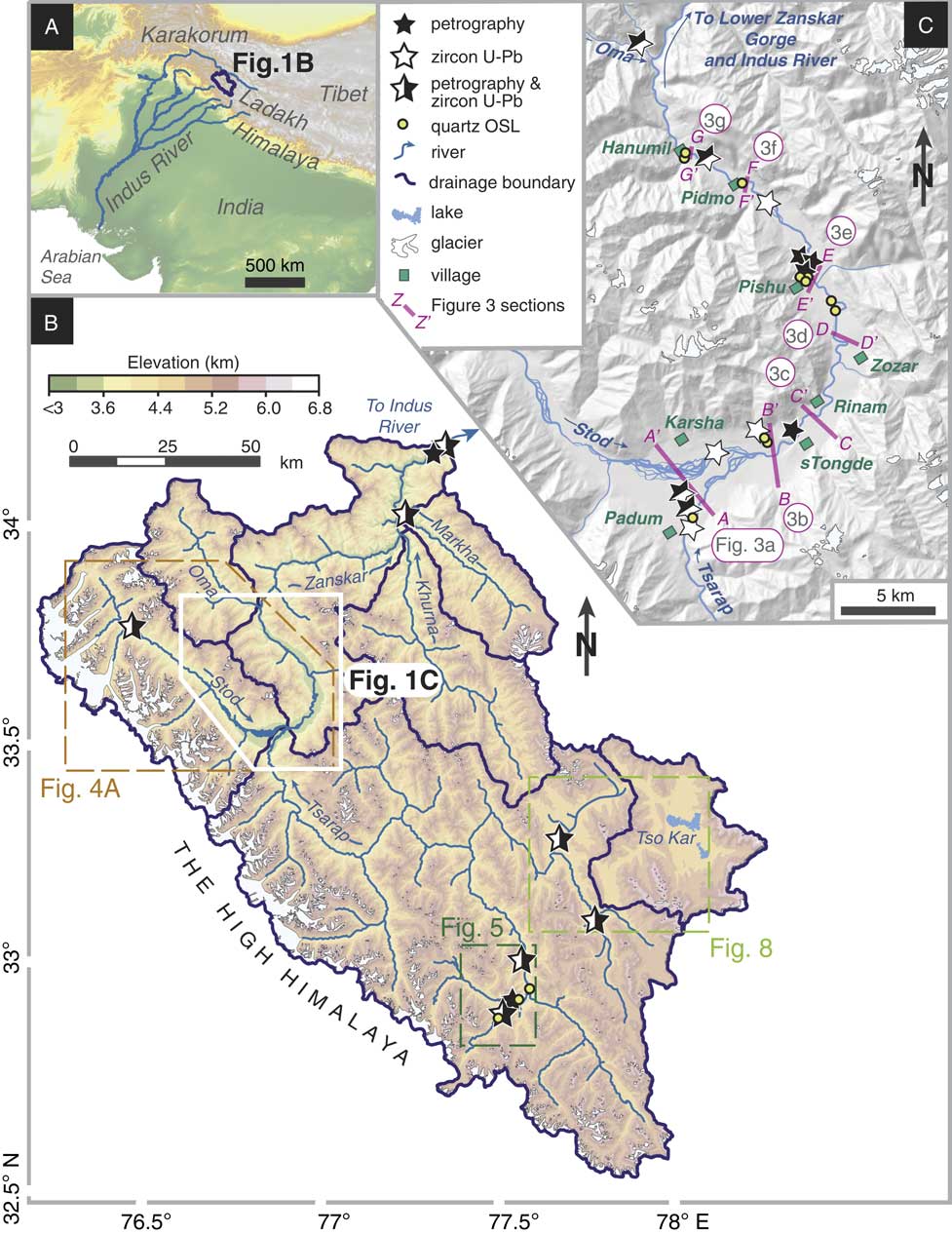
In this study, alluvial terraces are investigated in the Zanskar River basin, the largest tributary (14,939 km2) discharging to the upper Indus River (Fig. 1), to evaluate the effects of transient storage and erosion of valley-fill sediments into the modern and Quaternary Indus River. Through optically stimulated luminescence (OSL) dating, sediment petrography, and detrital U-Pb zircon analysis, the ages and sources of valley-fill sediments are defined to help establish spatial patterns of erosion since ~35 ka. Estimates for volumes of stored valley-fill sediments are made from field observations and morphometric analysis. These findings are compared with regional sediment budgets to improve understanding of how, and over what time scales, climatic phases may influence sediment flux to the trunk Indus River through formation and erosion of Quaternary valley fills lying within the Himalayan rain shadow.
Setting of the Zanskar River relative to South Asia. (A) Location of Indus River (blue) and Zanskar River basin (black outline; Fig. 1B). (B) Topographic map river drainage and sample locations outside of the Padum basin. Dashed boxes indicate location of Figures 1C, 4, 5, and 8. (C) Digital elevation model map over the Padum basin indicating major tributaries (blue), sample locations (stars), and Figure 3 terrace section locations (pink lines). Topographic data are from Shuttle Radar Topography Mission 30 m grid data (SRTM30). OSL, optically stimulated luminescence. (For interpretation of the references to color in this figure legend, the reader is referred to the web version of this article.)

BACKGROUND
Sediment buffering in the Indus River
The Indus River system has routed water and sediment from the Tibetan Plateau and western Himalaya to the Arabian Sea for at least the last ~45 Ma (Clift et al., Reference Clift, Shimizu, Layne, Blusztajn, Gaedicke, Schlüter, Clark and Amjad2001). Four major Indus tributaries drain the Himalayan foreland basin, with the upper trunk of the Indus River cutting up through the northwest Himalaya and Karakoram onto the Tibetan Plateau (Fig. 1).
Modern erosion and sediment transport rates positively correlate with increased rainfall and discharge from the frontal Himalaya (Galy and France-Lanord, Reference Galy and France-Lanord2001; Gabet et al., Reference Gabet, Burbank, Pratt-Sitaula, Putkonen and Bookhagen2008). Records from speleothems (Fleitmann et al., Reference Fleitmann, Burns, Mudelsee, Neff, Kramers, Mangini and Matter2003), marine cores (Prins et al., Reference Prins, Postma and Weltje2000; Gupta et al., Reference Gupta, Anderson and Overpeck2003; Staubwasser and Weiss, Reference Staubwasser and Weiss2006), central Asian paleolake sediments (Fang, Reference Fang1991; Gasse et al., Reference Gasse, Arnold, Fontes, Fort, Gibert, Huc, Bingyan, Yuanfang, Qing and Melieres1991, Reference Gasse, Fontes, Van Campo and Wei1996; Shi et al., Reference Shi, Yu, Liu, Li and Yao2001), and pollen records (Herzschuh, Reference Herzschuh2006) indicate strong Quaternary summer monsoon phases at ~44–34 ka and after the last glacial maximum (LGM; ~20 ka) to the mid-Holocene (~5 ka) across south and central Asia.
Summer monsoon intensity has critically controlled both the volumes and compositions of sediments delivered from the frontal Himalaya to the Indus delta and submarine fan, especially over the last ~20 ka. Strong shifts in bulk sediment Nd and Sr isotope geochemistry and detrital mineral provenance indicate increasing bedrock erosion along the frontal Himalaya synchronous with increasing monsoon rainfall intensity from 14 to 9 ka in Indus delta sediments (Clift et al., Reference Clift, Giosan, Blusztajn, Campbell, Allen, Pringle and Tabrez2008). In addition, mid- to late Holocene downcutting of the Indus River into the alluvial plain began to significantly rework floodplain sediments into the Indus delta (Giosan et al., Reference Giosan, Clift, Macklin, Fuller, Constantinescu, Durcan and Stevens2012). Until preindustrial damming of the Indus River, reworked valley-fill deposits were important to the overall delta sediment compositions (20–25% total mass flux), such that most other changes in upstream bedrock erosion and sediment provenance were strongly diluted (Clift and Giosan, Reference Clift and Giosan2014).
Dissected valley fills can be recognized even in the mountainous headwaters of the Indus River system across the Karakoram and Transhimalaya. Although some occur within steep bedrock gorges as a result of landslide and glacial damming (Hewitt, Reference Hewitt1998, Reference Hewitt2002; Dortch et al., Reference Dortch, Owen and Caffee2010; Korup et al., Reference Korup, Montgomery and Hewitt2010), alpine topography accommodates extensive alluvial sediments elsewhere in the northwest Himalaya. The longevity (~122–530 ka) of preserved valley-fill remnants attest to major cycles of Indus River aggradation and incision in the past (Blöthe et al., Reference Blöthe, Munack, Korup, Fülling, Garzanti, Resentini and Kubik2014; Munack et al., Reference Munack, Blöthe, Fülöp, Codilean, Fink and Korup2016). These deposits confirm long residence times and substantial erosion of sediments from the Indus headwater regions for at least the last two glacial cycles. Older moraine deposits (>385 ka; Owen et al., Reference Owen, Caffee, Bovard, Finkel and Sharma2006; Blöthe et al., Reference Blöthe, Munack, Korup, Fülling, Garzanti, Resentini and Kubik2014) and abundant dammed lacustrine sediments, together with preserved undated terraces >400 m above modern river level (Pant et al., Reference Pant, Phadtare, Chamyal and Juyal2005; Phartiyal et al., Reference Phartiyal, Sharma and Upadhyay2005), further testify to at least >0.5 Ma history of sediment storage and residence in the upper Indus River basin.
Nevertheless, the degree to which erosion of Himalayan valley-fill deposits contributes to Quaternary upper Indus River sediment flux remains largely unresolved. Volumetric estimates, combined with cosmogenic-nuclide derived evidence, suggest erosion of valley fills may easily dominate over contributions from fresh bedrock erosion since the Pleistocene (Blöthe and Korup, Reference Blöthe and Korup2013; Munack et al., Reference Munack, Blöthe, Fülöp, Codilean, Fink and Korup2016). Provenance studies, though just focused on the latest part of these time scales, do not indicate substantial erosion from Pleistocene terraces into the modern river bedload (Blöthe et al., Reference Blöthe, Munack, Korup, Fülling, Garzanti, Resentini and Kubik2014; Jonell et al., Reference Jonell, Carter, Böning, Pahnke and Clift2017) but also do not preclude valley-fill erosion having played a stronger role in the past under different climatic conditions and episodes of river incision. Although initial attempts to quantify buffering indicate rain shadow valley fills are not a dominant source in the Indus basin, these prior budgets were based on a number of assumptions and extrapolations that require age constraints and further validation from the field to establish their significance over wider areas of the Himalaya and over 103–104 yr time scales (Clift and Giosan, Reference Clift and Giosan2014).
Zanskar River climate and geology
This study investigates the Zanskar River, located in the Zanskar region of the Transhimalaya (Fig. 1). The modern Zanskar River basin can be divided into five subbasins of the main tributaries: the Tsarap, Stod, Khurna, Markha, and Oma. Adjacent to the Zanskar River basin is the internally drained Tso Kar basin (with an area of 1042 km2). Lying north of the orographic barrier of the High Himalaya on the periphery of the Tibetan Plateau, the Zanskar River is characterized alternately by narrow bedrock gorges with rugged topography and peaks that rise to >6000 m above sea level (asl), as well as by broad (3–6 km), glacially modified river valleys ranging in altitude from ~3000 to 4500 m asl. Much of the Zanskar River basin has an alpine, desert-steppe rain shadow climate (Hartmann, Reference Hartmann1987). A strong precipitation gradient is marked by higher mean annual precipitation (~400 mm/yr) along the backbone of the High Himalaya to only ~115 mm/yr in the Tso Kar basin (Bookhagen and Burbank, Reference Bookhagen and Burbank2006). Precipitation is delivered in the summer months (June to August) by the Asian summer monsoon that pushes across the High Himalaya into the Tibetan Plateau. In winter, snow is brought by the midlatitude winter westerlies (Benn and Owen, Reference Benn and Owen1998).
In contrast to the Himalayan foreland, there is little consensus on the impact of monsoon precipitation on erosion in the Transhimalaya. Under modern, average monsoon conditions, summer rainfall in semiarid to arid catchments represents ~40% of the mean annual precipitation and contributes as little as 26% to the total discharge (Bookhagen and Burbank, Reference Bookhagen and Burbank2010). Arid catchments receiving limited rainfall in the central Himalaya give commensurately low erosion rates (<0.1 mm/yr) in contrast to the summer monsoon–dominated catchments along the Himalayan front that yield rates of ~1–2 mm/yr (Gabet et al., Reference Gabet, Burbank, Pratt-Sitaula, Putkonen and Bookhagen2008; Burbank et al., Reference Burbank, Bookhagen, Gabet and Putkonen2012). Some observations indicate monsoon storms trigger hillslope erosion producing a significant (30–50%) part of the annual suspended sediment flux in only a few events (Wulf et al., Reference Wulf, Bookhagen and Scherler2010, Reference Wulf, Bookhagen and Scherler2012). Similar flood impacts in the Ladakh Transhimalaya document discharges exceeding ~75–100% more than bankfull loads after intense summer storms (Hobley et al., Reference Hobley, Sinclair and Mudd2012). Short-lived storm events, and potentially longer wetter monsoon phases, may critically control erosion from catchments that otherwise lack sufficient transport capacity under modern arid conditions (Bookhagen et al., Reference Bookhagen, Thiede and Strecker2005b; Hobley et al., Reference Hobley, Sinclair and Mudd2012).
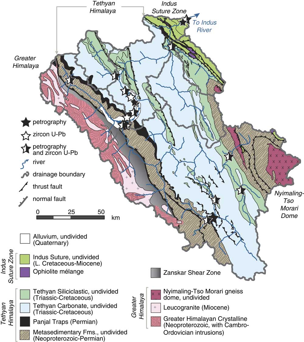
The bedrock geology of the Zanskar River basin (Fig. 2) can be grouped into three lithotectonic sequences: (1) the Greater Himalaya; (2) the Tethyan Himalaya; and (3) the Indus Suture Zone. The Greater Himalaya consists of Neoproterozoic-Ordovician paragneiss, metapelite, and orthogneiss (Honegger et al., Reference Honegger, Dietrich, Frank, Gansser, Thöni and Trommsdorff1982; Pognante et al., Reference Pognante, Castelli, Benna, Genovese, Oberli, Meier and Tonarini1990; Spring et al., Reference Spring, Bussy, Vannay, Huon and Cosca1993; Noble and Searle, Reference Noble and Searle1995; Horton and Leech, Reference Horton and Leech2013; Horton et al., Reference Horton, Lee, Hacker, Bowman-Kamaha’o and Cosca2015). These rocks are largely considered to be the deeply buried, high-grade equivalents of the Tethyan Himalaya sequence, the former passive margin of Greater India.
(color online) Simplified geologic map of the Zanskar River basin after Fuchs (Reference Fuchs1986), Fuchs (Reference Fuchs1987) with additions from Dèzes et al. (Reference Dèzes, Vannay, Steck, Bussy and Cosca1999), southern Zanskar (Lahul) from Steck et al. (Reference Steck, Spring, Vannay, Masson, Stutz, Bucher, Marchant and Tièche1993), and Tso Kar area (Epard and Steck, Reference Epard and Steck2008). Sample locations denoted by stars. Modified after Jonell et al. (Reference Jonell, Carter, Böning, Pahnke and Clift2017).

Neoproterozoic to early Paleocene carbonate and siliciclastic sedimentary rocks comprise the very low- to low-grade metasedimentary Tethyan Himalaya. Locally, Tethyan rocks reach lower amphibolite facies adjacent to the Nyimaling-Tso Morari dome and along the Zanskar Shear Zone, the ~150-km-long segment of the South Tibetan Detachment fault segregating the Greater and Tethyan Himalaya (Herren, Reference Herren1987; Steck, Reference Steck, Spring, Vannay, Masson, Stutz, Bucher, Marchant and Tièche1993; Dèzes et al., Reference Dèzes, Vannay, Steck, Bussy and Cosca1999). Paleozoic magmatic pulses produced two suites of igneous rocks in the Zanskar River basin: (1) Pan-Africa Orogeny Cambro-Ordovician (550–440 Ma) granitic plutons (Cawood et al., Reference Cawood, Johnson and Nemchin2007; Horton and Leech, Reference Horton and Leech2013) and (2) Gondwanan rifting Panjal Traps flood basalts (~289 Ma) and associated Mississippian-Permian (380–245 Ma) granitic plutons (Shellnutt et al., Reference Shellnutt, Bhat, Wang, Brookfield, Dostal and Jahn2012, Reference Shellnutt, Bhat, Wang, Brookfield, Jahn and Dostal2014). Rocks of the third lithotectonic sequence, the Indus Suture Zone, record sedimentation related to Cretaceous-Eocene subduction and collision of Greater India and Eurasia (e.g., Searle, Reference Searle1983; Searle et al., Reference Searle, Pickering and Cooper1990). Ophiolitic mélange, Indus Molasse sandstones, and Cretaceous-Eocene forearc basin strata are exposed along the easternmost part of the basin (Clift et al., Reference Clift, Carter, Krol and Kirby2002; Henderson et al., Reference Henderson, Najman, Parrish, BouDagher‐Fadel, Barford, Garzanti and Andò2010). This basin and the surrounding region have been relatively tectonically quiescent from the early to mid-Miocene (Schlup et al., Reference Schlup, Carter, Cosca and Steck2003; Kirstein et al., Reference Kirstein, Sinclair, Stuart and Dobson2006, Reference Kirstein, Foeken, Van Der Beek, Stuart and Phillips2009; Schlup et al., Reference Schlup, Steck, Carter, Cosca, Epard and Hunziker2011) with no significant neotectonic activity recorded since that time (Jade et al., Reference Jade, Rao, Vijayan, Gaur, Bhatt, Kumar, Jaganathan, Ananda and Kumar2010).
Contemporary glaciers remain strictly confined to north-facing headwalls within the Zanskar basin (Benn and Owen, Reference Benn and Owen1998; Dortch et al., Reference Dortch, Dietsch, Owen, Caffee and Ruppert2011; Kamp et al., Reference Kamp, Byrne and Bolch2011; Owen and Dortch, Reference Owen and Dortch2014), but the many broad, overdeepened intermontane valleys of the region indicate extensive past glaciation (Owen et al., Reference Owen, Caffee, Bovard, Finkel and Sharma2006; Korup et al., Reference Korup, Montgomery and Hewitt2010; Bolch et al., Reference Bolch, Kulkarni, Kääb, Huggel, Paul, Cogley and Frey2012; Blöthe and Korup, Reference Blöthe and Korup2013; Scherler et al., Reference Scherler, Munack, Mey, Eugster, Wittmann, Codilean, Kubik and Strecker2014). Glacial valley systems extended >50 km from present-day ice margins during the early last glacial period (Osmaston, Reference Osmaston1994; Mitchell et al., Reference Mitchell, Taylor and Osmaston1999; Hedrick et al., Reference Hedrick, Seong, Owen, Caffee and Dietsch2011). Since that time, glaciers retreated regionally, with only small glacier advances confined <15 km from present-day ice margins in their respective catchments during the late glacial period (16–14 ka), Neoglacial period (4–2 ka), and Little Ice Age (~300–200 yr BP; Burbank and Fort, Reference Burbank and Fort1985; Owen, Reference Owen2009; Owen and Dortch, Reference Owen and Dortch2014; Hedrick et al., Reference Hedrick, Owen, Chen, Robinson, Yuan, Yang and Imrecke2017).
METHODS
To assess the provenance of river terrace sediments and constrain timing of sediment aggradation in the Zanskar River basin, field observations, sediment petrography, and detrital zircon U-Pb geochronology were integrated with OSL dating. The potential role of sediment buffering in the upper Indus River is assessed using morphometric analysis to identify regions hosting significant Quaternary sediments and calculate stored sediment volumes.
Field observations and sampling
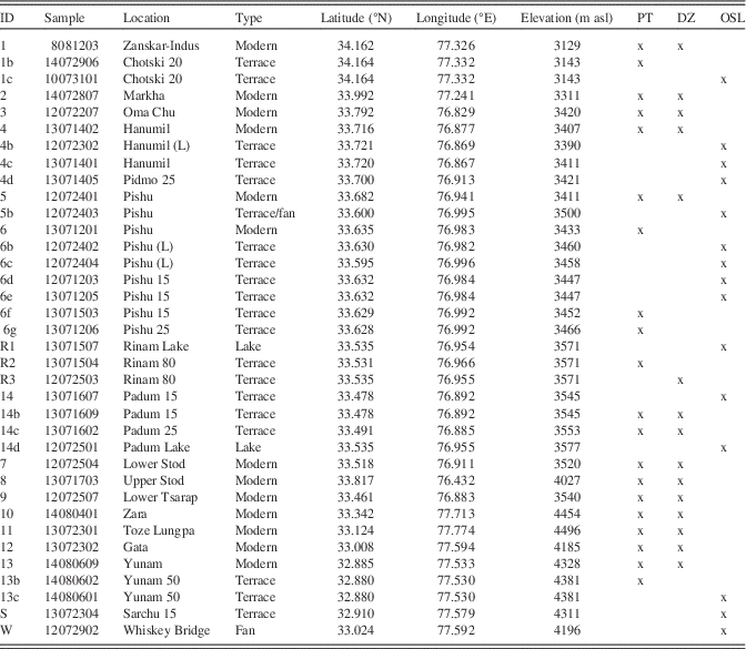
All locations, elevations, and heights relative to the modern river level of Quaternary alluvial terraces were mapped over three field seasons from 2012 to 2014 using Landsat Enhanced Thematic Mapper Plus (ETM+) imagery from Google Earth (http://www.google.com/earth) and handheld Garmin ETrex GPS devices with an estimated vertical accuracy of ±2 m and horizontal accuracy ±10 m. Very fine to medium sands (>63 μm) were preferentially sampled from coarse sediment lenses in alluvial terrace stratigraphy (Figs. 3–5). The sand-size fraction is preferred for detrital mineral provenance analysis because this fraction does not place limits on laser ablation spot sizes that may decrease analytical accuracy. Sample locations are presented in Table 1 and given a number identifier for easier reference for the reader.
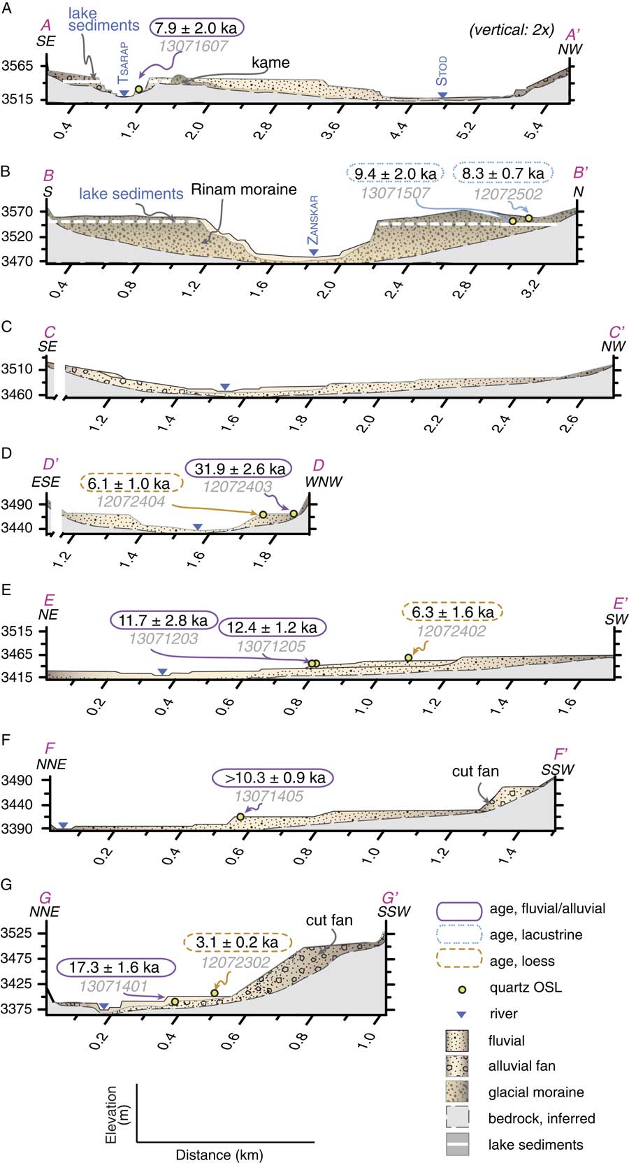
(color online) Schematic cross sections (A–G) of river terraces in the Padum basin. Section locations indicated in Figure 1C. OSL, optically stimulated luminescence.

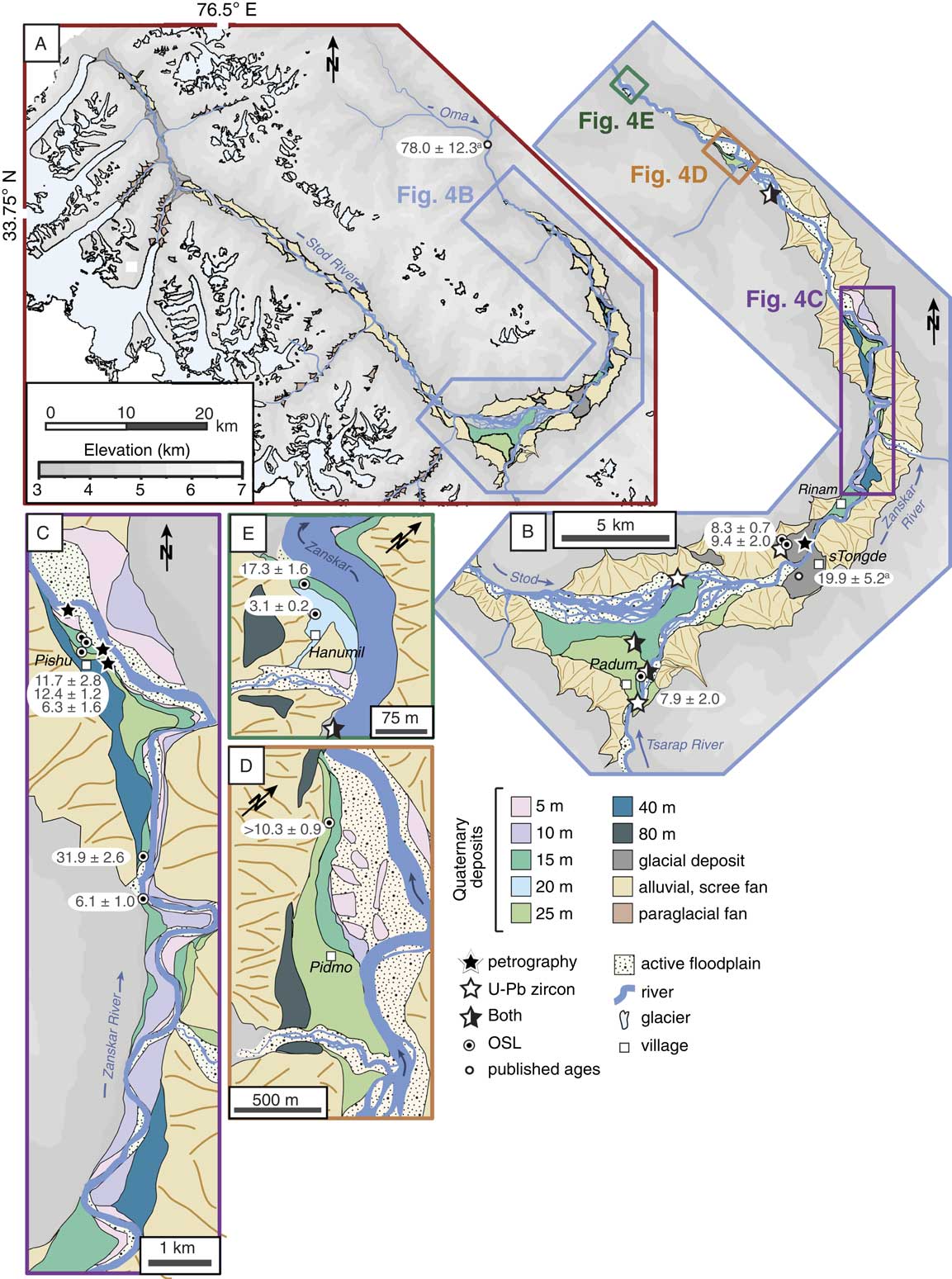
Geomorphological map of western Zanskar and Padum basin. (A) Quaternary deposits of Padum Basin and Stod River valley. (B) Quaternary deposits of Padum basin on trunk Zanskar River (blue lines). Boxes indicate locations of panels C–E. (C) Quaternary deposits at Pishu village. (D) Quaternary deposits at Pidmo village. (E) Quaternary deposits at Hanumil. Reported ages are from this study and Taylor and Mitchell (Reference Taylor and Mitchell2000), denoted with (a). OSL, optically stimulated luminescence. (For interpretation of the references to color in this figure legend, the reader is referred to the web version of this article.)

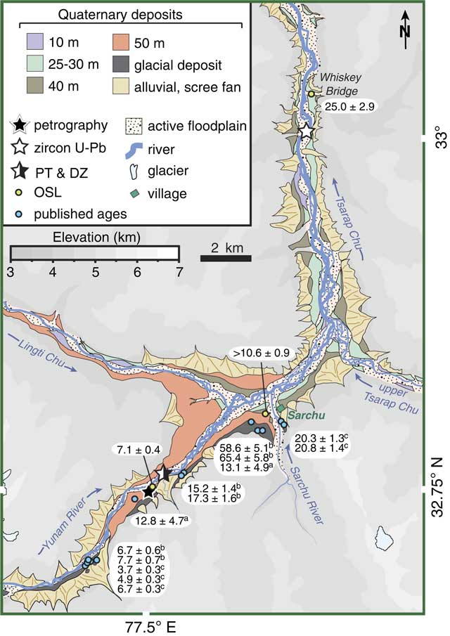
Geomorphological map of the eastern Zanskar River basin and Sarchu basin of upper Tsarap River (blue lines). Reported ages from this study and the following literature: (a) Taylor and Mitchell (Reference Taylor and Mitchell2000); (b) Saha et al. (Reference Saha, Sharma, Murari, Owen and Caffee2016); and (c) Sharma et al. (Reference Sharma, Chand, Bisht, Shukla, Bartarya, Sundriyal and Juyal2016). DZ, detrital zircon; OSL, optically stimulated luminescence; PT, sediment petrography. (For interpretation of the references to color in this figure legend, the reader is referred to the web version of this article.)

Sample locations for Zanskar River sediments. DZ, detrital zircon; OSL, optically stimulated luminescence; PT, sediment petrography.

Sediment petrography
Unsieved, bulk terrace sediments were counted in thin section with at least 200 points following the Gazzi-Dickinson method (Ingersoll et al., Reference Ingersoll, Bullard, Ford, Grimm, Pickle and Sares1984). All lithic fragments were classified by composition and in reference to the Metamorphic Index (MI) (Garzanti and Vezzoli, Reference Garzanti and Vezzoli2003; Vermeesch et al., Reference Vermeesch, Resentini and Garzanti2016). Grain mounts were stained with alizarin red-S to distinguish calcite from dolomite. Sediments were classified according to the proportion of the main fragments (Q, quartz; F, feldspars; L, lithic fragments) and named by abundance when exceeding10% QFL point counts (e.g., litho-feldspatho-quartzose sand, Q>F>L>10% QFL).
Environmental bias and intrasample variability as a result of hydrodynamic sorting processes were in part corrected for by applying a “source rock density” (SRD) correction to the bulk petrographic data. SRD corrections adjust the relative abundance of all lithic and mineral phases according to a specified bulk sediment density appropriate for sediment origin and degree of exhumation and erosion (Garzanti and Andò, Reference Garzanti and Andò2007a, Reference Garzanti and Andò2007b). Bulk petrographic data were corrected to an SRD value of 2.71 g/cm3, considered appropriate for regions of the Himalayan orogen exposing Tethyan and Greater Himalayan strata. Bulk petrographic data are reported in Table 2 and shown in Supplementary Figure 1.
Bulk petrography of Zanskar River terrace sediments.

Notes: &, andalusite, staurolite, chloritoid, olivine, spinel, and monazite; A, amphibole; Ap, apatite; B, biotite; Ep, epidote; F, all feldspar; Gt, garnet; Ky, kyanite; Lc, all carbonate excluding metacarbonate; Lm, all higher rank (3-5) metamorphic fragments; Lsm, all sedimentary and low rank (1-2) metasedimentary terrigenous fragments after Garzanti and Vezzoli (Reference Garzanti and Vezzoli2003); Lv, all volcanic fragments; Mu, muscovite; Px, pyroxene; Q, all quartz; Sil, sillimanite; ZTR, zircon, tourmaline, and rutile.
a Classified according to relative proportion of quartz (Q), feldspar (F), and lithic (L) material exceeding 10% of QFL total.
U-Pb zircon geochronology
Detrital zircon is a chemically and mechanically durable mineral phase in siliciclastic sediments such that multiple cycles of erosion do not significantly alter U-Th-Pb isotopic compositions (Gehrels, Reference Gehrels2014). U-Pb dating of zircon has become an affordable, common tool for constraining sediment provenance, and a chronological database exists for reference on rivers draining the Himalayan-Tibetan orogen (Amidon et al., Reference Amidon, Burbank and Gehrels2005; Alizai et al., Reference Alizai, Carter, Clift, VanLaningham, Williams and Kumar2011; Nie et al., Reference Nie, Stevens, Rittner, Stockli, Garzanti, Limonta and Bird2015). Here, the 63–250 µm size fraction is analyzed because this fraction yields all significant U-Pb age populations present in detrital sedimentary samples (Yang et al., Reference Yang, Zhang and Wang2012). The application of U-Pb zircon dating to Zanskar River terrace sediments is in part enabled from similar analysis of modern Zanskar sediments with this technique (Jonell et al., Reference Jonell, Carter, Böning, Pahnke and Clift2017).
Detrital zircon grains were separated using standard magnetic and heavy liquid separation techniques. Extremely magnetic material was removed using a rare earth element hand magnet prior to sieving to 63–250 μm. Zircon grains were mounted in epoxy, polished, and imaged.
U-Th-Pb isotopic compositions were determined at the London Geochronology Centre facilities at University College London using a New Wave 193 nm aperture-imaged frequency-quintupled laser ablation system, coupled to an Agilent 7700 quadrupole-based inductively coupled plasma mass spectrometer. An energy density of ~2.5 J/cm2 and a repetition rate of 10 Hz were used during laser operation. Laser spot diameter was ~30 μm with sampling depth of ~5 μm. Sample-standard bracketing by measurement of external zircon standard Plešovice (Sláma et al., Reference Sláma, Košler, Condon, Crowley, Gerdes, Hanchar and Horstwood2008) and National Institute of Standards and Technology 612 silicate glass (Sláma et al., Reference Sláma, Košler, Condon, Crowley, Gerdes, Hanchar and Horstwood2008) were used to correct for instrumental mass bias and depth-dependent intraelement fractionation of Pb, Th, and U. Temora (Black et al., Reference Black, Kamo, Allen, Aleinikoff, Davis, Korsch and Foudoulis2003) and 91500 (Wiedenbeck et al., Reference Wiedenbeck, Hanchar, Peck, Sylvester, Valley, Whitehouse and Kronz2004) were used as secondary zircon age standards. Over 100 grains were analyzed for each sample to provide a statistically robust data set for lithologically diverse units (Vermeesch, Reference Vermeesch2004). Age data were filtered using a +5 and −15% discordance cutoff. For grains with ages less than 1000 Ma, the 206Pb/238U ratio was used, and the 207Pb/206Pb ratio for grains older than 1000 Ma. Data were processed using GLITTER 4.4 data reduction software (Griffin et al., Reference Griffin, Powell, Pearson and O’Reilly2008). Time-resolved signals recording isotopic ratios with depth in each crystal enabled filtering to remove signatures owing to mixing from overgrowth boundaries, inclusions, and/or fractures. Individual U-Pb ages are reported at 1σ. Analytical data and individual U-Pb ages are presented in Supplementary Table 1.
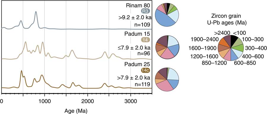
Detrital zircon U-Pb age data are presented in kernel density estimation (KDE) plots in the text for visual analysis of age population distributions and abundance (Fig. 6). KDE plots are favored in this study to prevent visual bias as traditional probability density functions may smooth older age populations with inherently larger age errors than younger populations at 1σ (Vermeesch, Reference Vermeesch2012). To quantitatively compare the intersample variability and compare age distributions with bedrock ages from the literature, the robust statistical multidimensional scaling (MDS) technique is applied using the open source ‘provenance’ package for R by Vermeesch et al. (Reference Vermeesch, Resentini and Garzanti2016). MDS analysis produces bivariate maps clustering samples presented here and against bedrock data compiled from literature based on Kolmogorov-Smirnov test dissimilarity (Figs. S2 and S3).
(color online) Kernel density estimation diagrams of detrital zircon U-Pb ages from Zanskar River terrace sediments with age interval ranges illustrated in pie diagrams.

OSL dating
To define the timing of terrace aggradation and the relative timing of terrace abandonment and fluvial incision, sediments were dated using OSL. For this investigation, sediments likely bearing 63–150 μm quartz grains were sampled because quartz is a commonly targeted mineral in luminescence dating techniques. Furthermore, the 63–150 μm size fraction is the most readily transported and deposited in a fluvial setting (e.g., Rhodes, Reference Rhodes2011). Samples were selected from sediment facies that are inferred to have received maximum light exposure during transportation, such as shallow channel sediments, to maximize bleaching and minimize inherited signals (Schaetzl and Forman, Reference Schaetzl and Forman2008). OSL samples were collected in ~15-cm-long aluminum tubes after cleaning surfaces of ~10 cm of material before sampling. All tubes were packed and wrapped with newspaper and UV-resistant tape, and double-bagged in opaque media for transport. OSL samples were processed and analyzed at the luminescence dating laboratories at the University of Cincinnati and the University of Oxford.
Quartz grains were isolated from heavy minerals and feldspars using pretreatment with HCl, HF, and fluorosilicic acids before heavy liquid separation and wet sieving. Modified single-aliquot regeneration (SAR) protocols (Wintle and Murray, Reference Wintle and Murray2006) were employed on small aliquots (200–500 grains; 100–150 μm in diameter) to estimate equivalent doses and establish signal growth curves. Ultrasmall aliquot (5–10 grains) quartz grain dating (Duller, Reference Duller2008) was undertaken if partial bleaching yielding skewed equivalent dose distributions was noted. This allowed age calculations even where populations of grains of various bleaching ages were present (Bailey and Arnold, Reference Bailey and Arnold2006; Jaiswal et al., Reference Jaiswal, Srivastava, Tripathi and Islam2008; Srivastava et al., Reference Srivastava, Tripathi, Islam and Jaiswal2008). Risø measurement systems were used to calculate paleodoses and dose response curves using a minimum of five SAR cycles under subdued sodium lighting (588 nm). Errors were estimated either with Monte Carlo simulation (2000 repeats) or calculated analytically, based on the difference between the fitted curve and dose points. Analytical uncertainties for OSL ages range typically from 5% to 10%. Estimations of the contribution of cosmic dose rate accounted for geographic position, elevation, topographic shielding, snow cover and depth, burial depth, and water content (Prescott and Hutton, Reference Prescott and Hutton1994).
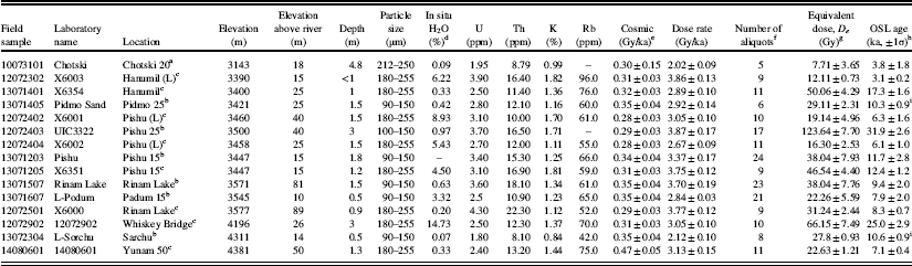
Field observations noted many prominent cut-and-fill aggradational terrace levels in two glacially modified basins at Padum and Sarchu (Figs. 3–5). Prominent terrace surfaces in each region were targeted because it was impractical to sample all terrace levels for dating. OSL age analyses are presented in Table 3. Field photographs outlining OSL sample locations and stratigraphy are included as Supplementary File 1.
Optically stimulated luminescence sample results.

a Department of Geography, Royal Holloway, University of London.
b Luminescence Dating Lab, Department of Geology, University of Cincinnati.
c Research Laboratory for Archaeology and the History of Art, University of Oxford.
d Assume 5±2 wt% H2O is representative of burial history.
e Contribution of cosmic radiation to the dose rate was calculated by using sample depth, elevation, and longitude/latitude following Prescott and Hutton (Reference Prescott and Hutton1994).
f Number of aliquots used for age calculation. Rejection of aliquots follows standard rejection criteria
g D e calculated using the minimum age model of Galbraith et al. (1999) unless otherwise noted; Excel macros written by Sébastien Huot (UQAM). Université du Québec à Montréal (UQAM).
h Uncertainty on age is 2-sigma standard error.
i Minimum age because of low intensity.
Basin morphology and sediment volumes
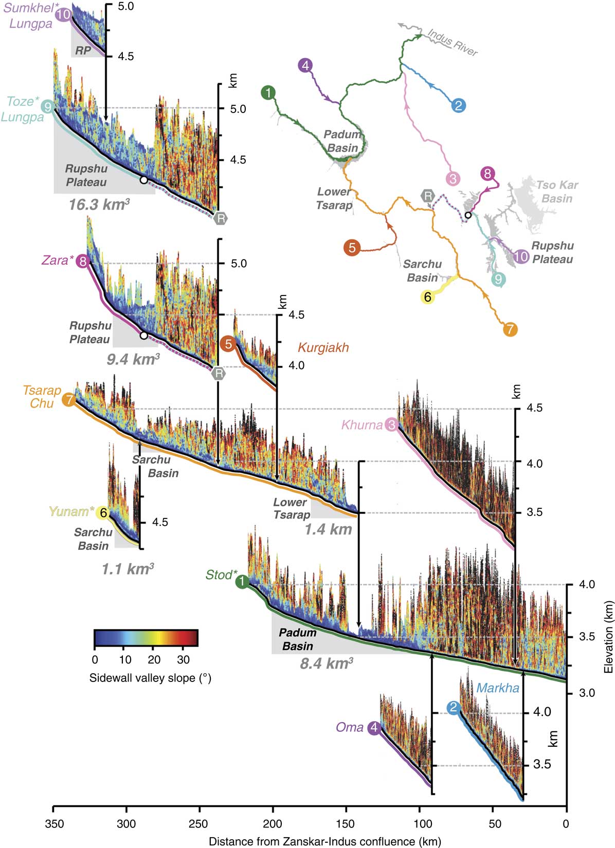
Digital elevation model (DEM) topographic data were derived from void-filled 30 m grid Shuttle Radar Topography Mission (SRTM30) data. Modern glacial extents are from Global Land Ice Measurements from Space (GLIMS) Version 1 data (Bajracharya et al., Reference Bajracharya, Shrestha, Bajracharya, Maharjan and Guo2014). River profile analysis was conducted using ArcGIS and TopoToolbox 2.0 for MATLAB (Schwanghart and Scherler, Reference Schwanghart and Scherler2014). Longitudinal river profiles were extracted for all major tributaries (draining more than 500 km2) and for smaller tributaries containing significant valley fills using a carve-and-fill hydrologic conditioning routine. To identify locations and approximate thicknesses of valley fills along each longitudinal profile, swath profiles were extracted orthogonally along each channel every 500 m. Swath widths extended to within 2 km of significant valley fills or to 1 km if hillslopes were ≥20º (Fig. 7).
Stacked elevation-slope channel profiles of the Zanskar River and locations of large valley-fill deposits. Slope values (<35°) were extracted along the river channel every 500 m orthogonal to the channel to confining bedrock hillslopes. Swath width was 2 km from river channel except rivers with bedrock confining hillslopes within 1 km of channel indicated by asterisks (*). Lower slope values (<10°, blue) are layered above higher slope values to indicate regions of sediment storage. To best illustrate the extent of Rupshu Plateau valley fills from Munack et al. (Reference Munack, Blöthe, Fülöp, Codilean, Fink and Korup2016), the Toze Lungpa and Zara River profiles overlap. Gray shaded regions on longitudinal profiles and within the inset indicate large valley fills in the Padum basin, lower Tsarap, Sarchu basin, Rupshu Plateau, and Tso Kar basin. Sediment volumes reported in Table 4 are next to each valley fill. Tso Kar basin valley fill is shown in light gray. RP, Rupshu Plateau (includes the More Plain). (For interpretation of the references to color in this figure legend, the reader is referred to the web version of this article.)

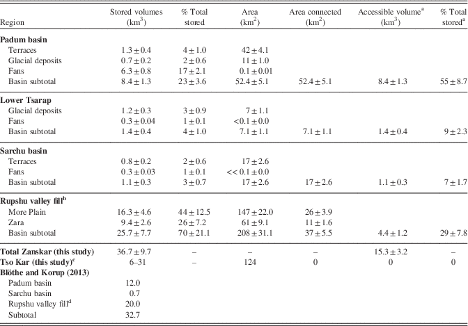
Table 4 summarizes volumes of sediments stored as Quaternary alluvial terraces, alluvial and paraglacial fans, and dissected glacial till in the Zanskar River and Tso Kar basins. Alluvial and paraglacial fan volumes were calculated individually for each feature after extracting landform geometries from Landsat ETM+ imagery and SRTM30 data. Fan volumes were determined using the fan apex to toe distance, apex and toe elevations, and fan toe circumference to calculate flat-based semicone volumes similar to the method of Giles (2010). Total fan volume estimates are assigned ±12% uncertainties reflecting that although fans are reasonably well defined, there are errors from measurement and simplified geometry that must be taken into account. Terrace volumes and dissected glacial till calculations followed a similar methodology to that of Clift and Giosan (Reference Clift and Giosan2014) that considered terrace volumes as triangular sediment wedges. Subplanar terrace treads were identified by low slope (<2°) areas and terrace risers as edges with hillslopes ~2–8°. Terrace thicknesses were measured manually from the DEM after identification. Measured terrace thicknesses were no deeper than modern river level or exposed adjacent bedrock and assumed subparallel surface treads and bases. Terrace thickness calculations were balanced by stratigraphic observations made in the field. Uncertainties for terrace volumes are no more than 28% after taking into account propagated errors from terrace height and areal measurements. Sediment volumes for hillslopes, periglacial deposits, and noneroded glacial valley sediments were not calculated because cover thickness and bedrock depth were unknown. This results in our budget representing a robust, albeit likely minimum, estimate for stored sediment volumes. Exported sediment volumes were calculated as trapezoidal sediment wedges using the cross-sectional area of removed material across the river channel and the length of the deposit along the longitudinal river profile. We account for minor errors in measurement of removed material along river, deposit thickness, and width and assign a propagated uncertainty of no more than ±8% on exported sediment volumes. Field photographs of the major basins and valley fills are included in Supplementary File 2.
Stored sediment volumes for Zanskar River and Tso Kar basins.

a Volumes within 500 m buffer zone on each side of river drainage.
b More Plain surface dated by Munack et al. (Reference Munack, Blöthe, Fülöp, Codilean, Fink and Korup2016).
c Tso Kar valley fill depth ranging 50–250 m.
d Includes More Plain and Tso Kar only.
RESULTS
Sediment petrography
Zanskar River terrace sediments contain a diverse assemblage of mineral and lithic fragments (Table 2). Framework petrography indicates abundant quartz, feldspar, low-rank metasedimentary and metacarbonate fragments, and high-rank fibrolite-bearing metafelsite fragments. Minor but notable fragments include serpentinized ultramafic and vesicular, porphyritic metabasite fragments. Abundant mineral phases include calcite and dolomite spar, micas, fibrolitic sillimanite, green and green-brown amphibole with minor garnet, zircon, and titanite. Bulk sediment compositions range from quartzolithic (meta-) carbonaticlastic to lithic metamorphiclastic.
Most terrace sediments approximately match rock compositions associated with Tethyan Himalaya provenance on a quartz-feldspar-lithic diagram (Supplementary Fig. 1). Exceptions to this are the eroded Rinam moraine (Table 1, ID #R2) and ~25 m Pishu terrace (ID #6g) samples that are more similar to Greater Himalayan sources. This in part is the result of the abundance of carbonate detritus in other sediments and slight enrichment in quartz and/or feldspar fragments, respectively, in Rinam and Pishu (Table 2).
U-Pb zircon geochronology
Detrital zircon spectra of the three terrace samples are presented as KDE diagrams following Vermeesch (Reference Vermeesch2004) in Figure 6. The ~15 m Padum terrace (ID #14) sample is characterized by minor Archean ages as old as ~3800 Ma; small Proterozoic populations at 2600–2400 Ma, 1650 Ma, and ~1500 Ma; and a broad, composite peak of zircon ages from ~1100 to 450 Ma. Within the composite peak are subsidiary peaks at ~950, ~850, ~750, 600–500 Ma (545 Ma peak), and ~450 Ma. One Miocene zircon yielded an age of 22.1±0.6 Ma. U-Pb zircon ages from ~25 m Padum terrace (ID #14c) yielded similar, prominent strong age peaks at ~750, ~530, and ~450 Ma, with smaller populations at 2600–2400, ~1800–1600, and ~1400 Ma. Younger zircons include one Miocene zircon at 25±0.9 Ma and two Permo-Triassic zircons at 281±7 and 251±7 Ma. The Rinam moraine sample (ID #R3) contains peaks at ~545, ~440, and 380–245 Ma, with a very strong peak at 850–650 Ma. This sample yielded the most Miocene zircon (n = 5) with ages ranging from 26 to 21 Ma.
OSL dating
Eleven new OSL samples were dated from the Padum basin (Figs. 3 and 4; Supplementary File 1). The confluence of the Stod and Tsarap Rivers near Padum village hosts two prominent terrace surfaces at 25–30 m and 10–15 m above modern river level (Figs. 3A and 4B). An OSL age from a coarse silt ~0.5 m below the top of the ~15 m terrace surface yielded an age of 7.9±2.0 ka. Downriver from the Stod-Tsarap confluence, 2–3 m of laminated lacustrine sediments overlie an incised 80- to 90-m-thick terminal moraine. Laminated silts ~1 m from the base of the section yielded an age of 8.3±0.7 ka (Figs. 3B and 4B). A fine laminated silt at the base of the section overlying poorly sorted, pebbly silt till was dated to 9.4±2.7 ka. Similar but less thick (~1 m) lacustrine sediments occurring at the same elevation are discontinuously exposed ~8 km upstream of the Rinam moraine at Padum village (Figs. 3A and 4A).
Several incised terrace surfaces were dated downstream of the Stod-Tsarap confluence near Padum village. Near Pishu village, a prominent ~40 m terrace composed of poorly sorted, matrix-supported sandy cobble conglomerate yielded an age of 31.9±2.6 ka from an interbedded ~0.2-m-thick medium sand lens (Figs. 3C and 4C). This ~40 m surface extends ~12 km upstream to Rinam village and discontinuously ~8 km downstream to Pidmo village (Figs. 3D and 4D). A discontinuous, thin (~0.5 m) loess cap occasionally exposed on top of the ~40 m terrace surface was dated to 6.1±1.0 ka at Pidmo village (Fig. 3D). At Pishu village, a similar thin loess cap (<0.5 m thick) overlying a ~25 m terrace surface yielded an age of 6.3±1.6 ka (Figs. 3E and 4C). The ~25 m terrace surface extends downstream ~8 km to Pidmo village and is often preserved adjacent to the ~40 m terrace surface (Fig. 4C). An OSL age of 10.3±0.9 ka was obtained from the top of the ~25 m terrace from a medium silt layer located ~1.5 m below a 0.5-m-thick silty-clay soil horizon at Pidmo village (Figs. 3F and 4D). At Pishu village, a very fine sand below a ~15 m terrace surface was dated beneath a 0.3-m-thick silty-clay soil horizon dated at 11.7±2.8 and 12.4±1.2 ka (Figs. 3E and 4C).
Terraces remnants are preserved as far downstream as Hanumil village in the Padum basin (Figs. 3G and 4E). An age of 17.3±1.6 ka was yielded from an interbedded fine sand between poorly sorted, pebble-supported sand at Hanumil village. A thin (<0.5 m) loess deposit found capping a 15–20 m terrace surface was also dated to 3.1±0.2 ka.
Extensive dissected alluvial fans and river terraces are found within the Sarchu basin (Fig. 5). A ~60-m-thick incised alluvial fan was dated near Whiskey Bridge. A coarse sand lens within poorly sorted sandy conglomerate yielded an age of 25.0±2.9 ka. A prominent terrace surface ~12–15 m above the modern river was dated near Sarchu village. A thin (0.25 m) medium sand lens interbedded in cobble conglomerate yielded a minimum age of 10.6±3.6 ka. One of the most prominent terrace surfaces in the Sarchu basin, a ~50-m-thick valley fill composed of alternating coarse sand, imbricated fluvial pebbles, and poorly sorted sandy conglomerate alluvial fan lenses, extends several kilometers along the Yunam River and Lingti Chu tributaries. A medium sand layer below a ~1-m-thick poorly sorted pebbly sand yielded an age of 7.1±0.4 ka.
Upstream of the Zanskar River–Indus River confluence at Choksti, one OSL sample from a ~20 m alluvial terrace perched on a bedrock strath terrace (Fig. 1B) yielded an age of 3.8±1.8 ka.
Basin morphology and sediment volumes
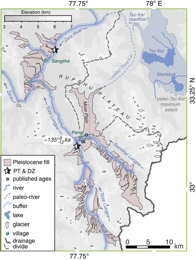
There are four regions storing significant sediment volumes in the Zanskar River basin: the Padum and Sarchu basins, the Rupshu Plateau, and the lower Tsarap River (Table 4; Fig. 7). The Padum basin, which here includes all sediments in the Stod River catchment, and from the Stod-Tsarap confluence downstream to Hanumil village, is estimated to hold 8.4±1.3 km3 of sediment, predominantly as alluvial and paraglacial fans (Fig. 4). Latest Pleistocene–earliest Holocene river terraces account for only 1.3±0.4 km3 of sediment. In the Sarchu basin, 1.1±0.3 km3 of sediment is divided among Pleistocene-Holocene terraces and mixed alluvial/scree fans. The greatest volumes of sediment in the Zanskar River basin are stored as dissected valley fills that include the ~135 ka Rupshu Plateau outlined by Munack et al. (Reference Munack, Blöthe, Fülöp, Codilean, Fink and Korup2016). Rupshu Plateau Pleistocene valley fills account for 25.7±7.7 km3 of sediment held as 110- to 150-m-thick valley fills in the Zara River catchment, and 90- to 240-m-thick valley fills held in the Toze Lunpga and Sumkhel Lungpa catchments (Fig. 8). We further estimate storage of sediment in the Tso Kar basin. Sediment volumes range from 6 to 31 km3 depending on the estimated valley-fill thickness (50–250 m) and a valley-fill area of ~124 km2. Dissected moraines and paraglacial fans in the lower Tsarap catchment host 1.4±0.4 km3 of sediment.
DISCUSSION
Quaternary sediment provenance
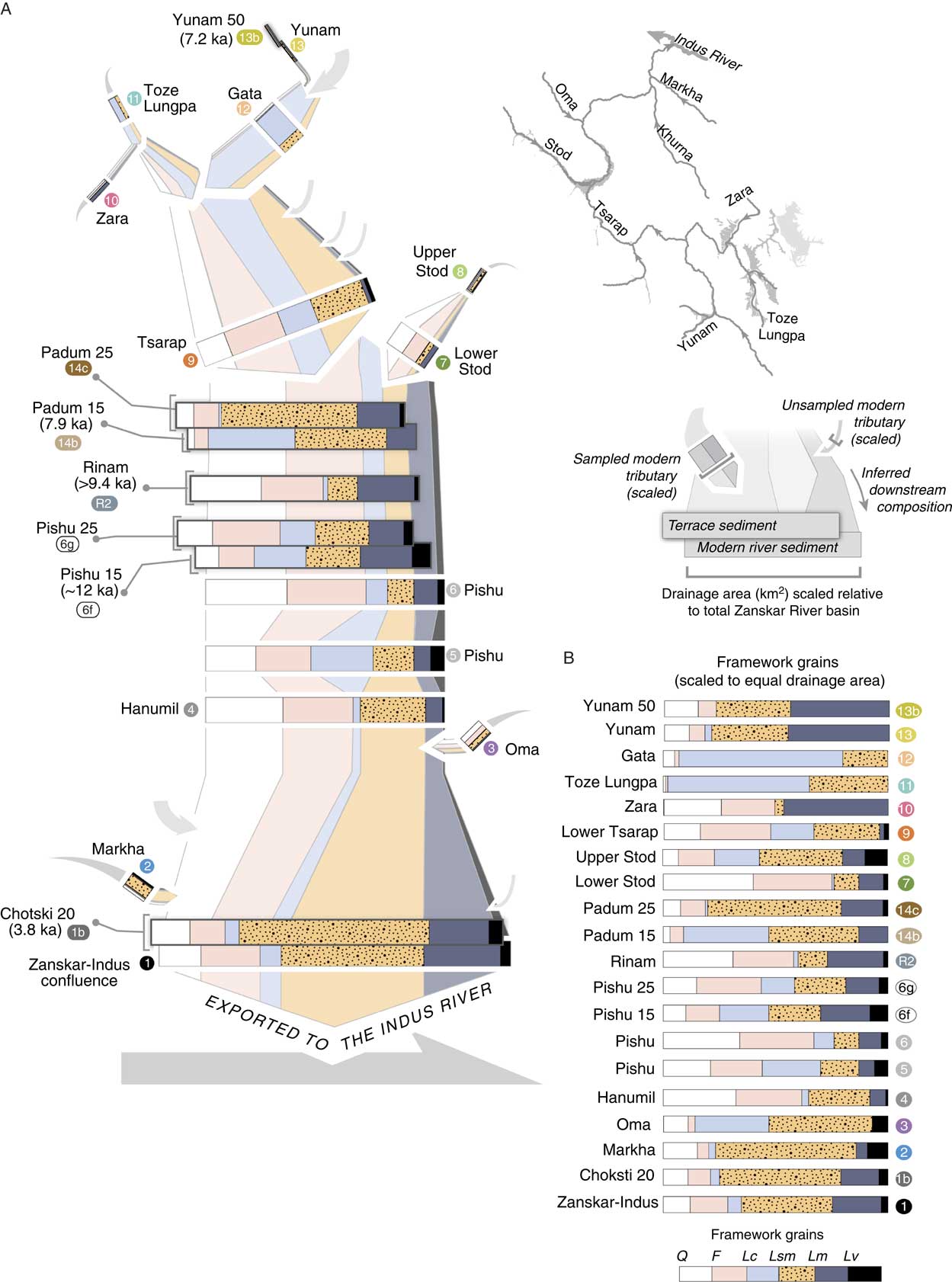
Spatial patterns of erosion can be constructed through time by tracking the compositional evolution of both modern river and dated terrace sediments downstream (Fig. 9). Data presented here are compared with similar analyses from modern Zanskar River sediments (Jonell et al., Reference Jonell, Carter, Böning, Pahnke and Clift2017) to elucidate how paleo–Zanskar River compositions evolved locally downstream. We further evaluate if incision of stored valley fills may have been influential to the overall net export of sediments to the Indus River.
The Stod River has been previously proposed as the most significant source of sediment to the Zanskar River because of the abundance of Greater Himalayan lithic fragments, quartz and feldspar fragments, and abundant detrital zircon with peak ages of 850–750, ~450, and ~350 Ma for sediment from the modern river (Jonell et al., Reference Jonell, Carter, Böning, Pahnke and Clift2017). Downstream of the Stod River–Tsarap River confluence to form the trunk Zanskar River, sediments vary little until the trunk river enters the Zanskar Gorge (Fig. 9). Sediments evolve downstream to include more sedimentary and low-rank metasedimentary fragments from Tethyan Himalayan exposed along the bedrock gorge. If all tributaries are scaled to upstream contributing area, the greatest apparent contributor of sediment to the trunk Zanskar River is the Tsarap River catchment (Fig. 9A). Petrographic and detrital zircon data indicate that it is the smaller, slightly wetter, and glaciated Stod River catchment that has strongly moderated downstream sediment compositions with material from the Greater Himalaya not only under modern environmental conditions as suggested by Jonell et al. (Reference Jonell, Carter, Böning, Pahnke and Clift2017), but consistently over the Holocene.
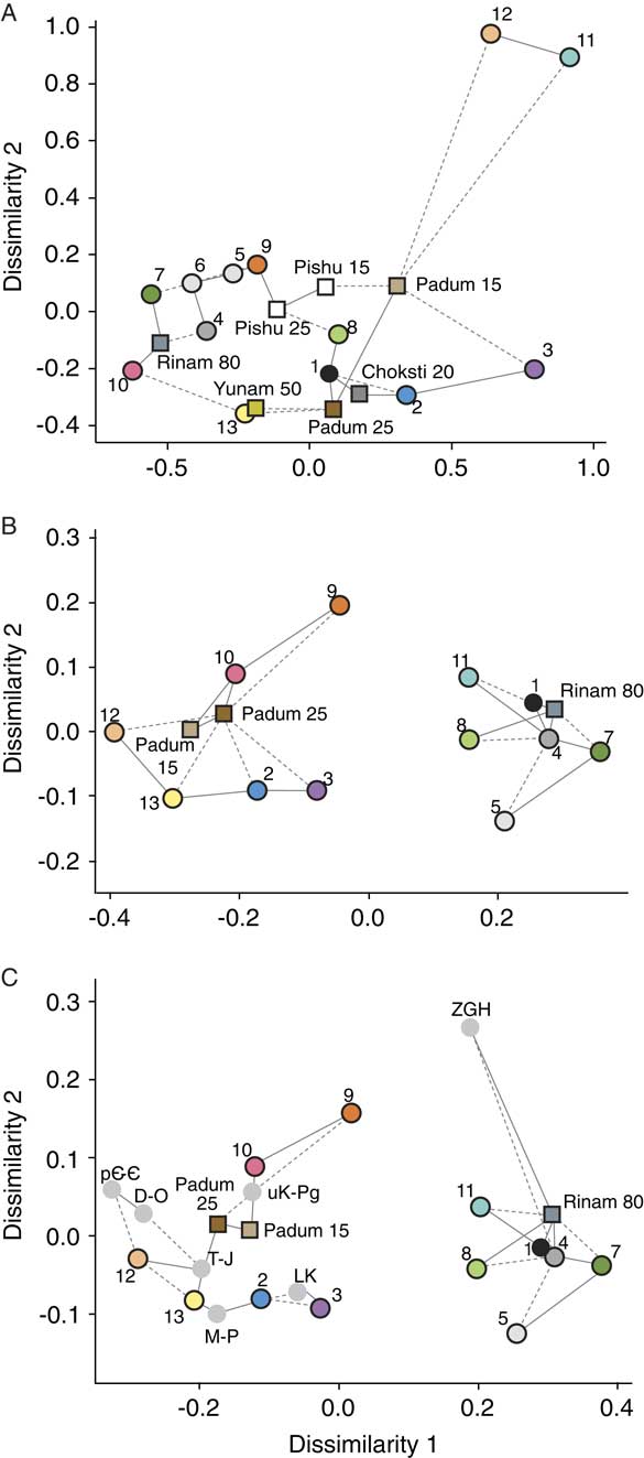
New data from Quaternary deposits suggest that erosion and recycling of Rinam moraine sediments along the trunk Zanskar River may also in part strongly control downstream sediment compositions for at least the last 12 ka. MDS analysis of bulk sediment point counts from the Rinam moraine (ID #R2) indicate closest similarity in provenance to the modern lower Stod (ID #7) and Zara (ID #10) River samples because of similar abundance of quartz and feldspar fragments (Fig. 10A). MDS analysis discretely groups Rinam moraine detrital zircon (ID #R2) with the modern Zanskar-Indus confluence (ID #1), Hanumil (ID #4), Pishu (ID #5), upper Stod (ID #8), and lower Stod (ID #7; Fig. 10B) sediments that all contain prominent age peaks mentioned previously (Supplementary Fig. 3).
It is most likely that Rinam moraine sediments were deposited from a valley glacier originating from the Stod River valley, eroding Zanskar Greater Himalaya rocks (Fig. 10C; Supplementary Fig. 2). Provenance data support this model because all significant zircon U-Pb age populations in the Zanskar Greater Himalaya are also identified in detrital zircon yielded from the Rinam moraine. Furthermore, Rinam yields high-grade lithic and fibrolitic sillimanite fragments associated with Greater Himalayan rocks within and outside the Zanskar River basin. Although MDS analysis of petrographic data (Fig. 10A) suggests the Zara River (ID #10) as a potential source, this is only a product of the coarse quartz and feldspar grains found in both the Rinam moraine and Zara River samples (Fig. 9; Table 2).
OSL ages in the Padum basin can be used to establish limits on glacial extent along the trunk Zanskar River, as well as the age of the Rinam moraine. Terrace age data require that the valley glacier system extended no farther than Hanumil village after ~17.4 ka and retreated past Pishu village by ~12 ka and to past Padum village by ~7.9 ka (Fig. 4). Many Padum basin incised alluvial fans ~40–80 m above the modern river imply a much earlier retreat. If an alluvial fan dated at ~32 ka (Table 3, sample 12072403) is considered representative of alluvial fan sedimentation in the basin, then the river may have been glacier-free downstream of Pishu village before the LGM. These data follow along with previous findings from Taylor and Mitchell (Reference Taylor and Mitchell2000) arguing for a glacial maximum extent beyond Hanumil village from ~78 ka until at least 40 ka and a subsequent retreat to Rinam village by 19.9±5.5 ka. Our data generally agree with the chronology of Taylor and Mitchell (Reference Taylor and Mitchell2000), although the accuracy of these earlier OSL ages has been called into question (Owen et al., Reference Owen, Gualtieri, Finkel, Caffee, Benn and Sharma2002).
Similarly, time constraints on the incision of the Rinam moraine can be inferred. The age of the lake sediments dammed behind the Rinam moraine requires the moraine to be older than ~9.4 ka, with damming having occurred at least by that time (Figs. 3 and 4B). Moraine dissection must have occurred after lake sedimentation ended at ~8.2 ka, if not before upstream river incision through correlative lake sediments and Padum basin terrace aggradation at ~7.9 ka. If we consider that dissection occurred by ~7.9 ka, and if incision occurred over ~4.8 km of the river through the thickness of the moraine (80 m), an estimated 0.3±0.03 km3 of moraine material was transported into the Zanskar River downstream since that time. This volume equates to ~22% of the total stored sediment at present in the Padum basin (Table 4). If dissection of glacial valley-fill deposits held in the Stod River were also incised at that time, this would provide an additional 0.2±0.02 km3 of sediment.
Although erosion of valley-fill deposits significantly controls sediment compositions in the Padum basin, side valley contributions within the Zanskar Gorge moderate this effect downstream. Sediment compositions at the Zanskar River–Indus River confluence are not identical to those in the Padum basin (Figs. 9B and 10). This can be observed at least over the last ~3.8 ka as recorded at Choksti (ID #1b), suggesting that the bulk provenance of sediment fluxed from the Zanskar River to the trunk Indus has not changed significantly since at least that time.
Nonetheless, intrabasinal temporal provenance variations are recorded in terraces of fill-cut series in the Padum basin (Fig. 9B). First, a shift in provenance is noted between the ~25 m Pishu terrace (ID #6g) and the ~15 m Pishu terrace (ID #6f). Compositions at ~12 ka included more gneiss, calc-gneiss, fibrolitic sillimanite, and volcanic fragments than younger sediments (Table 2). This could suggest either increased erosion of Greater Himalayan and Panjal Traps bedrock exposed upstream along the Stod River and around Padum village or increased erosion of glaciofluvial outwash sediments derived earlier from Greater Himalayan and Panjal Traps bedrock. The relative contributions from fresh or reworked sediment cannot be determined using these new data, but we argue that erosion of valley fills is the most important sediment supply because deeply incised glaciofluvial gravels are observed throughout the Stod River valley (Fig. S2).
The provenance of terraces near Padum reflects a broad change in erosion patterns across the Tsarap River basin between 12 and ~7.9 ka. Between construction of the ~25 m (ID #14c) and ~15 m (ID #14b) Padum terraces, compositions evolved to include more Tethyan Himalayan lithologies (Figs. 9 and 10). Sediment compositions changed from predominantly high- and low-grade metamorphic fragments to include abundant carbonate, as also observed in the modern upper Tsarap River (ID #11, 12). Detrital zircon U-Pb ages also document a subtle shift by ~7.9 ka from populations similar to Triassic-Jurassic strata to populations found more in upper Cretaceous and Paleogene siliciclastic strata (Fig. 10B and C). Together these data sets suggest a general shift from concentrated erosion of rocks exposed in the High Himalaya in the west and southwest of Zanskar to a broader erosional regime also tapping sediment sources in the eastern Zanskar River basin.
We infer that increasing influence of the summer monsoon and winter westerlies drove enhanced erosion and produced this marked intrabasinal shift in sediment provenance by ~7.9 ka. Before deposition of the ~15 m Padum terrace by ~7.9 ka, erosion was concentrated predominantly in regions exposing Greater Himalaya and Neoproterozoic to Jurassic Tethyan Himalaya (Fig. 2). This is similar to modern-day conditions where precipitation and erosion are focused along the High Himalaya (Jonell et al., Reference Jonell, Carter, Böning, Pahnke and Clift2017). By 7.9 ka, increased yield from rocks exposed in the eastern Zanskar River implies increased erosion of Tethyan Himalaya bedrock and/or large-scale erosion of voluminous Rupshu Plateau sediments held in the upper Tsarap River catchment. Net incision of Padum basin terraces must have occurred by ~6.2 ka (Fig. 3). Loess deposits preserved on some Padum terrace levels definitively mark abandonment of Padum basin terraces by that time. A second loess cap at Hanumil indicates abandonment and incision of terrace surfaces there at the latest by 3.1 ka (Fig. 4).
At least one phase of Pleistocene alluvial fan sedimentation and one phase of aggradation can be defined in the Sarchu basin (Fig. 5). Alluvial fan sedimentation at Whiskey Bridge was active until at least 25.6 ka. Aggradation of glaciofluvial outwash gravels in the Sarchu basin began before ~10.6 ka. The low intensity of induced luminescence during OSL dating underscores that this is a minimum age, and therefore, valley infilling must have initiated earlier. Sharma et al. (Reference Sharma, Chand, Bisht, Shukla, Bartarya, Sundriyal and Juyal2016) suggest much earlier deposition over Marine Oxygen Isotope Stage 3 (~57–29 ka) for much of the Sarchu basin, where data here indicate either a second phase or a continuing phase of aggradation through ~7 ka as marked by the ~50 m terrace along the Yunam River (Table 3).
Incision within the Sarchu basin can be constrained in part using the recent glacial landform chronology of Saha et al. (Reference Saha, Sharma, Murari, Owen and Caffee2016). Glaciers extended no farther than Sarchu village as early as ~60 ka, then retreated to the middle Yunam River valley by ~16 ka and the upper Yunam River valley by ~7 ka. With these previous chronologies, a younger Holocene phase of net incision is established in the Sarchu basin after ~7 ka that worked to shape many of the prominent terraces surfaces ≤50 m in height.
Evacuated sediment from the Sarchu basin, in a similar fashion to the Padum basin, is predominantly sourced from glaciofluvial outwash rather than freshly eroded bedrock. The prominent ~50 m terrace shares similar petrography to the modern Yunam River (Figs. 9 and 10A). Both contain abundant gneiss, calc-gneiss, and foliated metapelite fragments from deformed, medium- to high-grade Neoproterozoic-Triassic rocks exposed upstream. We suggest a minimum of 0.5±0.06 km3 has been eroded and exported from the ~50 m terrace along the Yunam River and adjacent Lingti Chu since terrace abandonment at early as ~7 ka.
Quaternary climate and sediment dynamics
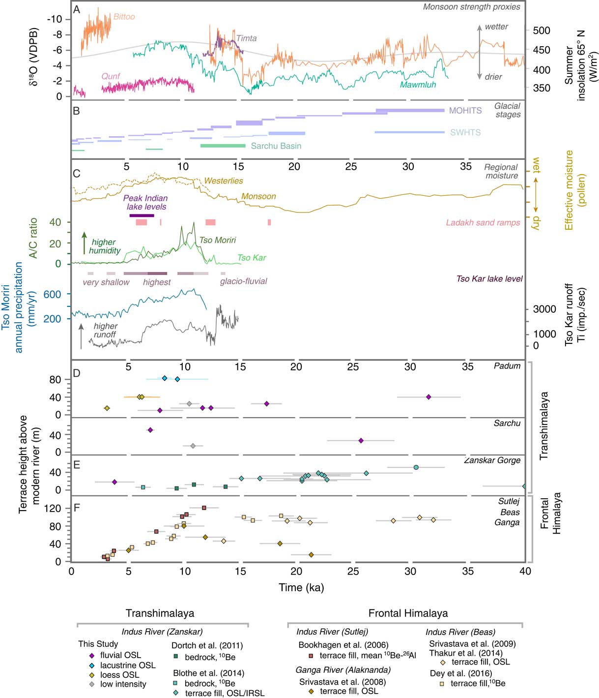
The data presented here provide new constraints on Pleistocene and Holocene infilling and erosion that expand prior chronologies across the Zanskar River basin and other neighboring Transhimalayan basins (Dortch et al., Reference Dortch, Dietsch, Owen, Caffee and Ruppert2011; Blöthe et al., Reference Blöthe, Munack, Korup, Fülling, Garzanti, Resentini and Kubik2014; Munack et al., Reference Munack, Blöthe, Fülöp, Codilean, Fink and Korup2016). From these findings, a late Pleistocene to Holocene sedimentation history can be constructed for the middle and upper Zanskar River basin (Fig. 11). Age constraints pinpoint at least two early phases of net aggradation and at least one younger net phase of incision: late Pleistocene alluvial fan sedimentation from at least ~32–25 ka with potentially concurrent deglacial aggradation; latest Pleistocene–earliest Holocene aggradation (~12–8 ka); and mid-Holocene net incision initiating by ~8–6 ka across the Zanskar River basin and continuing to the present. Near the Zanskar-Indus confluence, a small phase of late Holocene local aggradation at Choksti is recorded at ~3.8 ka with ~20 m of incision since that time.
Ages from bedrock and alluvial terraces along the Zanskar River Gorge and Zanskar-Indus confluence indicate major aggradation at ~50–20 ka, with two younger phases of net incision at 14–9.5 ka and prior to 6.3 ka (Dortch et al., Reference Dortch, Dietsch, Owen, Caffee and Ruppert2011; Blöthe et al., Reference Blöthe, Munack, Korup, Fülling, Garzanti, Resentini and Kubik2014). Fluvial phases presented here from the middle and upper Zanskar River correspond with regional aggradation (~15–10 ka) and incision (<10–8 ka) in the frontal Himalaya that was previously shown to covary with monsoon strength (Pratt et al., Reference Pratt, Burbank, Heimsath and Ojha2002; Bookhagen et al., Reference Bookhagen, Fleitmann, Nishiizumi, Strecker and Thiede2006; Srivastava et al., Reference Srivastava, Tripathi, Islam and Jaiswal2008; Thakur et al., Reference Thakur, Joshi, Sahoo, Suresh, Jayangondapermal and Singh2014; Dey et al., Reference Dey, Thiede, Schildgen, Wittmann, Bookhagen, Scherler, Jain and Strecker2016). Although temporal correlation between these two regions implies a common driver (i.e., summer monsoon intensity), glaciation and winter midlatitude westerlies strength also strongly control fluvial and sedimentation dynamics in the Transhimalaya (Demske et al., Reference Demske, Tarasov, Wünnemann and Riedel2009; Wünnemann et al., Reference Wünnemann, Demske, Tarasov, Kotlia, Reinhardt, Bloemendal and Diekmann2010; Lee et al., Reference Lee, Seong, Owen, Murari, Lim, Yoon and Yoo2014; Owen and Dortch, Reference Owen and Dortch2014; Mishra et al., Reference Mishra, Anoop, Schettler, Prasad, Jehangir, Menzel, Naumann, Yousuf, Basavaiah and Deenadayalan2015)
Hillslope processes operating at high elevation in semiarid regions, such as frost cracking and salt weathering, cannot be discounted as strong drivers of erosion in the Zanskar River basin (e.g., Bull and Knuepfer, Reference Bull and Knuepfer1987; Hales and Roering, Reference Hales and Roering2005, Reference Hales and Roering2007; Scherler et al., Reference Scherler, Munack, Mey, Eugster, Wittmann, Codilean, Kubik and Strecker2014). High-altitude hillslope processes are well recognized as primary generators of sediment along the Indus River valley and within the Rupshu Plateau (Blöthe et al., Reference Blöthe, Munack, Korup, Fülling, Garzanti, Resentini and Kubik2014; Dietsch et al., Reference Dietsch, Dortch, Reynhout, Owen and Caffee2015; Munack et al., Reference Munack, Blöthe, Fülöp, Codilean, Fink and Korup2016). We argue that although hillslope processes are effective at generating sediment in high-elevation, arid regions within the Zanskar River basin, these processes are less influential than periglacial and fluvial processes in controlling the net export of sediments from the Zanskar River. The slower rates at which hillslope processes operate in the presently unglaciated catchments of Zanskar (i.e., the Rupshu Plateau) are not comparable to either the rates or volumes of sediments exported from the active, glaciated catchments.
Variations in the intensity of the summer monsoon and westerlies worked in concert with local glaciation to produce late Quaternary aggradation and incision, as recorded in the Zanskar River basin. Enhanced precipitation and rising temperatures associated with a strong monsoonal phase at 29–24 ka (Bookhagen et al., Reference Bookhagen, Thiede and Strecker2005a) coincided with local glacier retreat to further promote local aggradation and alluvial fan sedimentation (32–25 ka) along oversteepened Zanskar River valley walls (Sharma et al., Reference Sharma, Chand, Bisht, Shukla, Bartarya, Sundriyal and Juyal2016). This interval of increased moisture transport across the High Himalaya is recorded throughout the western Tibetan Plateau in lake sediments (Gasse et al., Reference Gasse, Arnold, Fontes, Fort, Gibert, Huc, Bingyan, Yuanfang, Qing and Melieres1991, Reference Gasse, Fontes, Van Campo and Wei1996; Shi et al., Reference Shi, Yu, Liu, Li and Yao2001), pollen records (Herzschuh, Reference Herzschuh2006), and river terraces (Dortch et al., Reference Dortch, Dietsch, Owen, Caffee and Ruppert2011).
Later strengthening of the summer monsoon and westerlies into the early Holocene corresponded with increased erosion along the High Himalaya and aggradation in the Padum basin beginning ≥12 ka and ending at ~8 ka. This relationship with rainfall contrasts with work from glaciated mountain valleys in New Zealand where valley aggradation is associated with times of colder, drier climate (Bull and Knuepfer, Reference Bull and Knuepfer1987). This disparity likely reflects the fact that the New Zealand example receives much more annual precipitation (800–1200 mm/yr) in a glaciated maritime climate, with the highest basin elevations near but below modern treeline at ~1150 m. The Zanskar River, in contrast, receives as much as 450 mm to <100 mm/yr (basin average =320 mm/yr) precipitation, with elevations between ~3100 and above 6000 m asl, and lies predominantly above the treeline in a cold desert-steppe climate. Expansion of strong precipitation during the Holocene climatic optimum further into the Himalayan rain shadow by ~8 ka triggered significant erosion of the Tethyan Himalaya bedrock as well as fluvial incision of the Rupshu Plateau valley fills. Early to mid-Holocene lake records document a very wet, warm interval from 11.8 to 7 ka at Tso Kar (Demske et al., Reference Demske, Tarasov, Wünnemann and Riedel2009; Wünnemann et al., Reference Wünnemann, Demske, Tarasov, Kotlia, Reinhardt, Bloemendal and Diekmann2010) and at ~11–8 ka in Tso Morari (Leipe et al., Reference Leipe, Demske and Tarasov2014; Mishra et al., Reference Mishra, Anoop, Schettler, Prasad, Jehangir, Menzel, Naumann, Yousuf, Basavaiah and Deenadayalan2015). These data sets align with the model presented here, suggesting a shift from isolated erosion along the High Himalaya to broader, more regional erosion across the Zanskar River basin during the Holocene climatic optimum, as strong moist monsoonal and westerlies systems penetrated into the Tibetan Plateau for a prolonged time.
Subsequent weakening of the summer monsoon and westerlies led to decreased moisture transfer through the mid-Holocene that resulted in decreased river discharge, lower sediment flux by 7–6 ka, and net terrace incision on the northern side of the High Himalaya. Incision occurs because the rivers were carrying less sediment from the higher reaches and had excess carrying capacity that allowed them to erode into their former valley fills. With continued weakening of the summer monsoon and westerlies into the late Holocene, Tethyan Himalaya sediment flux waned. Basin-wide fluvial terrace incision and deposition of loess within Zanskar indicate a drying of the climate, consistent with several paleomonsoon climate records for that time (e.g., Prins et al., Reference Prins, Postma and Weltje2000; Fleitmann et al., Reference Fleitmann, Burns, Mudelsee, Neff, Kramers, Mangini and Matter2003). Modern focused glacial erosion and precipitation along the west and southwest edge of the Zanskar River basin supports relatively higher Greater Himalayan sediment flux and continued incision of valley fills.
The sensitivity of the edge of the western Tibetan Plateau to climate-modulated buffering may directly reflect its location relative to the Himalaya rainfall maximum. The southwest edge of the Zanskar River basin lies ~100 km from the rainfall maximum, compared with >200 km to the Zanskar River–Indus River confluence and ~180 km to the Rupshu Plateau. The Zanskar River basin is not unique among Transhimalayan basins in containing large valley fills, but it may be that only marginal basins, including possibly the upper Sutlej River basin (i.e., Wulf et al., Reference Wulf, Bookhagen and Scherler2012), receive enough moisture to overcome thresholds for transport capacity that otherwise is extremely limited in high and dry Tibetan plateau interior basins (Dietsch et al., Reference Dietsch, Dortch, Reynhout, Owen and Caffee2015). Such valleys are also subject to periglacial frost cracking when the moisture supply reaches a high enough level that in turn is known to be a very efficient mechanism for generating large sediment volumes (Walder and Hallet, Reference Walder and Hallet1985; Hales and Roering, Reference Hales and Roering2005). Working together, these processes can drive significant sediment transport.
Quaternary buffering and sediment recycling
Quaternary valley fills account for 36.7±9.7 km3 of stored material in the Zanskar River basin, with roughly 70% of this volume (~26 km3) held in the Rupshu Plateau (Fig. 8 and Table 4). The overall volumetric estimates presented here are strikingly consistent with previous valley-fill estimates (32.7 km3) using DEM algorithm-based extraction (Blöthe and Korup, Reference Blöthe and Korup2013). Previous basin-specific estimates from Blöthe and Korup (Reference Blöthe and Korup2013) underestimate volumes in the Sarchu basin (~1.1 vs. 0.69 km3) while overestimating volumes in the Padum basin (~8.4 vs. 11.9 km3). These differences likely result from direct field evidence regulating calculations in this study, especially concerning valley-fill extent and depth. Nevertheless, the general agreement between these studies reinforces the general scale of the sediment budget and furthermore highlights the effectiveness of each technique in assessing sediment volumes over particular spatial scales.
Although the results discussed here indicate considerable sediment stored in the Zanskar River basin, not all of the stored sediment is readily erodible. Some valley-fill deposits may be relatively disconnected from the drainage network, such as sediments perched ~250–300 m above the entrenched rivers of the Rupshu Plateau. In that area, the older sediments are preserved in terraces that fill valleys that stretch far from the modern river channel. Because they receive little rainfall, there is minimal transfer of material from the terraces to the modern stream (Supplementary Fig. 2). This study attempts to account for this connectivity by using a 1-km-wide buffer around the drainage network to approximate how much sediment can be eroded into the river drainage through lateral incision, bank failure, and localized debris flows. This width is an arbitrary distance based on observations from modern incision patterns that can establish a conservative estimate. Volumes of erodible sediment adjust to 15.3±3.2 km3 for the total Zanskar River. This is comparable to the estimates for the total eroded sediment volumes over the last ~10 ka of 7–22 km3 (Clift and Giosan, Reference Clift and Giosan2014), which were based on extrapolation of rates estimated from the trunk Indus River and are thus not very reliable. Further calculations indicate an additional ~4 km3 of erodible sediment stored in the Rupshu Plateau. These corrected volumes imply that much of the Rupshu Plateau valley fill is relatively isolated from the modern Zanskar River system. Deep incision and excavation (11–19 km3; Table 5) over the last ~135 ka reflects considerable erosion of valley-fill deposits in the plateau interior (Munack et al., Reference Munack, Blöthe, Fülöp, Codilean, Fink and Korup2016). In contrast, provenance data here indicate limited contribution of Rupshu Plateau sediments to the modern sediment budget since 8 ka. These valley fills were most likely eroded before the mid-Holocene, and since then they have been insignificant to the net sediment budget.
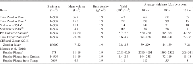
Zanskar River sediment yield estimates.

a Adjusted volumes for sediment connectivity.
b Sediment >35 ka is Rupshu Plateau valley fill.
c Stored (36.7 km3) + eroded volumes (7–22 km3) from Clift and Giosan (Reference Clift and Giosan2014) and (11–19 km3) Munack et al. (Reference Munack, Blöthe, Fülöp, Codilean, Fink and Korup2016).
d Stored and connected (15.3 km3) + eroded volumes (7–22 km3) from Clift and Giosan (Reference Clift and Giosan2014).
e More Plain, Toze Lungpa, Sumkhel Lungpa only.
To assess how erosion of valley fills from the Zanskar River might contribute to regional upper Indus River sediment budgets over longer time scales, average yield rates over several possible residence intervals—10, 20, and 135 ka (Table 5)—were calculated. Yield rates for the last 10 ka were estimated at 89–279 t/km2/yr based on eroded sediment budgets derived from field observations of terrace height and incised width (Clift and Giosan, Reference Clift and Giosan2014). If these eroded budgets are accurate, then the pre-Holocene total stored sediment volume would have reached ~45–60 km3. This suggests that ~42–77% of stored Zanskar River sediments (excluding the Rupshu Plateau) have been excavated and transported to the trunk Indus River since 10 ka.
Blöthe and Korup (Reference Blöthe and Korup2013) estimated ~177 km3 of stored valley fill in the upper Indus River basin. The Zanskar River basin comprises ~7% of the upper Indus drainage area and a moderate ~21% of the total stored volume, of which at least ~9% is available for modern erosion. We propose that the Zanskar River may have a disproportionate influence on upper Indus River sediment volumes and compositions, especially if neighboring Transhimalaya valley fills in the plateau interior are isolated like the Rupshu Plateau. Sufficient transport capacity might only be achieved during episodic high-precipitation intervals when previously isolated plateau interior valley fills are eroded significantly into the trunk Indus River. In this context, marginal rain shadow river basins, which equally produce and mobilize abundant sediment, can strongly modify the Himalayan rain shadow sediment budget. Yet this also underscores that Transhimalayan valley fills, although volumetrically significant, modulate the total Indus River sediment budget much less than previously envisaged (Blöthe and Korup, Reference Blöthe and Korup2013; Clift and Giosan, Reference Clift and Giosan2014).
CONCLUSIONS
This study defines the episodic infilling of volumetrically large Quaternary valley fills within the Zanskar River basin, the largest tributary to the upper Indus River, and marks coherent shifts in downstream sediment provenance as valley fills were periodically dissected. A new river terrace chronology documents at least two major phases of late Pleistocene–early Holocene aggradation. The first phase at 32–25 ka correlates in part with local deglaciation and strong South Asian summer monsoon and winter westerlies–derived precipitation. A second phase of aggradation initiated before 12 ka and lasted until ~8 ka, coinciding again with a strengthening summer monsoon. Over this time, aggradation is similarly documented along the frontal Himalaya (Bookhagen et al., Reference Bookhagen, Fleitmann, Nishiizumi, Strecker and Thiede2006). Net Holocene incision as the climate dried, accompanied by loess sedimentation, initiated by 7–6 ka and was likely continuous through the present. Much of the bedrock erosion is controlled directly by glaciers and periglacial frost cracking, which in turn are modulated by summer monsoon and winter westerlies precipitation. Results from this study support the concept that regions of the Transhimalaya lying immediately north of the topographic divide may not only be sensitive to abnormal monsoonal excursions (Bookhagen et al., Reference Bookhagen, Thiede and Strecker2005b), but also record strong monsoon phases over the last ~35 ka. This work highlights the control of the monsoon in addition to glaciation in landscape evolution on the periphery of the Tibetan Plateau.
Data presented here identify ~37 km3 of stored sediment in the modern Zanskar River, but only ~16 km3 of this is readily erodible. These values are consistent with previously published budgets, despite being estimated by different methodologies. Zanskar River valley fills host ~18% of the total upper Indus River sediment (~177 km3) in only ~7% of its drainage area but may disproportionately contribute to the total upper Indus budget during particular climatic regimes. If many Transhimalayan valley fills within the plateau interior are isolated from the trunk river and/or are without sufficient transport capacity, then sedimentary signals to the trunk upper Indus will be fluxed primarily from those basins on the margin and will not be representative for all sectors of the Transhimalaya.
Deconvolving sedimentary signals preserved in offshore archives strictly in terms of climate or tectonically driven erosion continues to be problematic because sediment buffering occurs over many spatial and temporal scales and is now documented to occur prolifically even within mountain source regions. This study indicates that climatically modulated sediment buffering has occurred over 103–104 yr time scales in the upper Indus River and locally presents biases in both sediment compositions and volumes that need to be accounted for when analyzing sequences deposited farther downstream. Climate, and in particular precipitation, governs Himalayan rain shadow erosion more strongly than previously recognized. This observation highlights that millennial-scale climate variations can strongly pace landscape evolution in arid mountain belts and even further regulate the long-term dissection and decay of orogenic plateaus.
Pleistocene Rupshu Plateau valley fills (pink) of the More Plain and upper Tsarap River tributaries, the Toze Lungpa, Sumkhel Lungpa, and Zara River (blue lines). Tso Kar maximum extent (shaded blue) after Wünnemann et al. (Reference Wünnemann, Demske, Tarasov, Kotlia, Reinhardt, Bloemendal and Diekmann2010). Proposed paleo-Toze Lungpa drainage (dashed blue) and reported in situ 10Be exposure ages of ~135 ka for the Rupshu Plateau from the More Plain (Munack et al., Reference Munack, Blöthe, Fülöp, Codilean, Fink and Korup2016). DZ, detrital zircon; PT, sediment petrography. (For interpretation of the references to color in this figure legend, the reader is referred to the web version of this article.)

(color online) Bulk petrography of framework grains from selected terrace sediments and modern river tributary sediments (Jonell et al., Reference Jonell, Carter, Böning, Pahnke and Clift2017). (A) Downstream mixing schematic of river and terrace sediments from the trunk Zanskar River and major tributaries. Bars are proportionally scaled to the upstream contributing drainage area relative to the area of the Zanskar River basin (14,939 km2). (B) Comparison of all sediment samples assuming equal upstream contributing drainage area. F, feldspars; Lc, lithic carbonate; Lm, medium- to high-rank metamorphic; Lsm, other sedimentary and low-rank metasedimentary; Lv, volcanic and metavolcanic; Q, quartz. Framework categories follow Garzanti and Vezzoli (Reference Garzanti and Vezzoli2003). Samples are labeled and numbered after Table 1.

Multidimensional scaling (MDS) plots showing the Kolmogorov-Smirnov distances between modern Zanskar River sediments (color circles), river terrace sediments (squares), and local bedrock (gray circles). Number labels follow Table 1. (A) Nonmetric MDS plot of source rock density–corrected bulk petrographic data. (B) Nonmetric MDS plot of all Zanskar River detrital zircon U-Pb ages. (C) Zanskar River terrace sediments compared with modern Zanskar River sediments and compiled regional Himalayan bedrock U-Pb zircon ages (Figs. S1 and S2). Solid lines indicate closest neighbor and dashed lines nearest next neighbors. Data plotted using R ‘provenance’ package by Vermeesch et al. (Reference Vermeesch, Resentini and Garzanti2016). Bedrock abbreviations mostly follow depositional ages: D-O, Devonian to Ordovician; LK, lower Cretaceous; M-P, Mississippian to Permian; pЄ-Є, Proterozoic to Cambrian; T-J, Triassic to Jurassic; uK-Pg, upper Cretaceous to Paleogene; ZGH, Zanskar Greater Himalayan bedrock (Horton and Leech, Reference Horton and Leech2013). (For interpretation of the references to color in this figure legend, the reader is referred to the web version of this article.)

(color online) Selected Quaternary paleoclimate and paleoenvironmental proxies for South Asia. (A) Monsoon strength proxies compiled from cave records from Qunf, Oman (Fleitmann et al., Reference Fleitmann, Burns, Mudelsee, Neff, Kramers, Mangini and Matter2003); Bittoo, India (Kathayat et al., Reference Kathayat, Cheng, Sinha, Spötl, Edwards, Zhang, Li, Yi, Ning and Cai2016); Mawmluh, India (Dutt et al., Reference Dutt, Gupta, Clemens, Cheng, Singh, Kathayat and Edwards2015); and Timta, India (Sinha et al., Reference Sinha, Cannariato, Stott, Li, You, Cheng, Edwards and Singh2005), with summer insolation for 65°N (Berger and Loutre, Reference Berger and Loutre1991). VPDB, Vienna Pee Dee belemnite. (B) Glacial stages for the northwestern Himalaya. Monsoonal Himalayan-Tibetan stages (MOHITS) after Murari et al. (Reference Murari, Owen, Dortch, Caffee, Dietsch, Fuchs, Haneberg, Sharma and Townsend-Small2014), semiarid western Himalaya-Tibetan stages (SWHTS) after Dortch et al. (Reference Dortch, Owen and Caffee2013), and Sarchu basin from Saha et al. (Reference Saha, Sharma, Murari, Owen and Caffee2016). Bar heights indicate relative uncertainty for each stage. (C) Records for moisture transport from central Asian lake pollen records (Herzschuh, Reference Herzschuh2006), compiled lowland Indian lake levels (Clift and Plumb, Reference Clift and Plumb2008), eolian Ladakh sand ramps (Kumar et al., Reference Kumar, Srivastava and Meena2017), and pollen and paleohydrologic records from Tso Moriri (Leipe et al., Reference Leipe, Demske and Tarasov2014; Mishra et al., Reference Mishra, Anoop, Schettler, Prasad, Jehangir, Menzel, Naumann, Yousuf, Basavaiah and Deenadayalan2015) and Tso Kar (Demske et al., Reference Demske, Tarasov, Wünnemann and Riedel2009; Wünnemann et al., Reference Wünnemann, Demske, Tarasov, Kotlia, Reinhardt, Bloemendal and Diekmann2010). (D) Optically stimulated luminescence (OSL) depositional ages of river terraces from the Zanskar River (this study). (E) 10Be exposure ages and OSL/infrared-stimulated luminescence (IRSL) depositional ages of river terraces in the lower Zanskar Gorge (Dortch et al., Reference Dortch, Dietsch, Owen, Caffee and Ruppert2011; Blöthe et al., Reference Blöthe, Munack, Korup, Fülling, Garzanti, Resentini and Kubik2014). (F) Select frontal Himalaya river terrace ages from the Sutlej (Bookhagen et al., Reference Bookhagen, Thiede and Strecker2006), Beas (Srivastava et al., Reference Srivastava, Rajak and Singh2009; Thakur et al., Reference Thakur, Joshi, Sahoo, Suresh, Jayangondapermal and Singh2014; Dey et al., Reference Dey, Thiede, Schildgen, Wittmann, Bookhagen, Scherler, Jain and Strecker2016), and Alaknanda Rivers (Srivastava et al., Reference Srivastava, Tripathi, Islam and Jaiswal2008). Cosmogenic nuclide ages for the Transhimalaya and frontal Himalaya were recalculated using CRONUS-Earth online calculators, Version 2.2. Error bars are 1σ.

ACKNOWLEDGMENTS
This study was supported by the Charles T. McCord Jr. Chair in petroleum geology at Louisiana State University (LSU) and in part by a Geological Society of America Graduate Student Research Grant and LSU scholarships. This manuscript was greatly improved by constructive reviews from Luca Malatesta and one anonymous reviewer. The authors thank Tom Stevens for one OSL analysis incorporated into this study from Royal Holloway University of London. TNJ and PDC thank Fida Hussein Mittoo and family with Rockland Tourism, and Arundeep Ahluwalia from Panjab University for logistical support. TNJ appreciates fruitful discussions with Henry Munack and Jan Blöthe about morphometric analysis in Ladakh.
Supplementary material
To view supplementary material for this article, please visit https://doi.org/10.1017/qua.2017.92