INTRODUCTION
Academic research on urbanism has debated the push-and-pull factors that drove people to uproot their lives and move into these novel settlements that for their day were unprecedented social experiments. Among the often-cited factors are a need to unite in the face of conflict or external threat (Carneiro Reference Carneiro1970; Flannery Reference Flannery, Flannery and Marcus1983; Spencer Reference Spencer2010) or the “pull” that charismatic leaders and urban facilities and experiences can have on a population (Flannery Reference Flannery1999; Joyce Reference Joyce2004; Joyce and Winter Reference Joyce and Winter1996). Once people moved into cities, they either reaped the benefits or came to regret their new living conditions, being so close and under the thumb of urban authorities. In addition, we must consider that urban dwellers often experience other problems such as overcrowding, poverty, higher propensity to disease, and inadequate sanitation. A notable case is Teotihuacan, whose targeted destruction is thought to be result of its own population's disillusion with the rulership after a period of declining living conditions (Storey Reference Storey1992). This article focuses on Cerro Jazmín, a hilltop city in the Mixteca Alta highlands of Oaxaca. Instead of discussing the factors that brought people to the city in the first place, we focus on the sociopolitical maneuvers and urban-planning strategies used to gain and maintain the compliance of the population. We do this by presenting new data on two monumental areas and discussing what the timing and nature of their use and construction suggest about the shifting political strategies of the city's leaders.
The Mixteca Alta is a temperate and mountainous region that covers the western portion of the Mexican state of Oaxaca. Although well within the tropics, its elevation and its high rugged mountains give the region a dry temperate climate with a summer rain season and common winter frosts. Although narrow valleys occur throughout the Mixteca Alta, the largest of which is the Nochixtlan Valley (approximately 15 by 15 kilometers), ancient Mixtecs consistently opted to build their settlements on hilltops and slopes in favor of using flat land for agriculture.
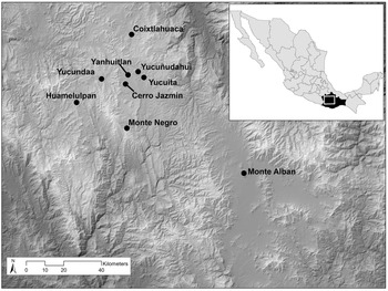
Based on our excavations and associated radiocarbon dates, we know that Cerro Jazmín was established by 300 b.c. on the northwestern edge of the Nochixtlan Valley (Figure 1; for radiocarbon data, see Pérez Rodríguez et al. [Reference Pérez Rodríguez, Tuñón, Minc, Walsh and Rosales2017b:Table 1, Reference Pérez Rodríguez, Tuñón and Ponce de León2018:Table 1]). Regional settlement data suggest that Cerro Jazmín's founding population came from the villages of the nearby area of Xacañi (Kowalewski et al. Reference Kowalewski, Balkansky, Stiver-Walsh, Pluckhahn, Chamblee, Rodríguez, Heredia Espinoza and Smith2009:31–32). Since the very foundation of the settlement, its inhabitants and rulers invested a great deal of labor to modify the mountain's natural terrain. Before the first house or mound were ever built on Cerro Jazmín, an organized labor force cut and shaped the hill slope through terracing and box-and-fill construction. During the city's Late Formative occupation (300 b.c. to a.d. 50), the hilltop and the Sunken Courtyards, a monumental area directly below and to the east of the hilltop, were the focus of monumental construction and feasting (Pérez Rodríguez et al. Reference Pérez Rodríguez, Tuñón, Stiver Walsh, Roldán and Estévez2017a). This spatial configuration shifted later, when a larger and more accessible monumental area on the mid-northern slope was constructed and expanded in the Terminal Formative period (a.d. 50 to 200/300). The architectural, stratigraphic, and radiocarbon evidence we present document the development and change of Cerro Jazmín's layout, providing clues to how these changes may have been related to the city's governance. Additional radiocarbon dates (n = 30) and chronological information that allowed us to establish the presently known sequence of occupation at Cerro Jazmín have been published by Pérez and colleagues (Pérez Rodríguez et al. Reference Pérez Rodríguez, Tuñón, Minc, Walsh and Rosales2017b:Table 1, Reference Pérez Rodríguez, Tuñón and Ponce de León2018:Table 1).
Map showing the location of Cerro Jazmín in Oaxaca and Mexico. Map by Martínez Tuñón.

MIXTECA ALTA URBANISM
The Mixteca Alta has been the focus of archaeological attention since the 1930s when scholars first excavated nearby sites like Monte Negro, Yucuita, and Yucuñudahui (Acosta and Romero Reference Acosta and Romero1992; Caso Reference Caso1938; Gaxiola Reference Gaxiola1984; Guzmán Reference Guzmán1934; Nagoda and Scarborough Reference Nagoda and Scarborough1983; Winter Reference Winter1989; Winter et al. Reference Winter, Alicia Herrera, Spores and Fialko1991). Unlike the Valley of Oaxaca, where Monte Albán was unmatched in size and complexity from the Late Formative to the Late Classic period, in the Mixteca Alta not one, but multiple hilltop urban polities developed in the Late Formative period, and this pattern persisted up to the Postclassic.
From these pioneering projects at Yucuita, Huamelulpan, and Monte Negro, sites comparable to Cerro Jazmín in their placement in the regional settlement hierarchy, we learned that no two Mixtec cities were architecturally alike (Balkansky et al. Reference Balkansky, Rodríguez and Kowalewski2004). Urban layouts varied, but all sites shared a general construction pattern that initially focused on the hilltop, following a narrow linear configuration that matched the ridge, and that construction later expanded out and down slope. Dozens of cascading terraces sculpt the hillsides and create a complex maze of residential spaces and pedestrian walkways that surround different clusters of monumental areas.
Among the better-known Formative-period cities of the Mixteca Alta are Huamelulpan, Yucuita, Monte Negro, and now Cerro Jazmín (Acosta and Romero Reference Acosta and Romero1992; Caso Reference Caso1938; Winter et al. Reference Winter, Alicia Herrera, Spores and Fialko1991). The smaller hilltop settlement of Xatachio was also excavated in a salvage project (Martínez Tuñón and Robles García Reference Martínez Tuñón and Robles García2010) but many other sites, such as the recently recorded Naduza-Ñiaxuge in the Coixtlahuaca Valley, remain to be studied (García Ayala Reference García Ayala2011). Some explorations into the monumental structures in the sites previously mentioned confirm their function as areas for ritual activity, feasting, and high-status burial. To date, however, there has not been a discussion on the level of access that the general population may have had to these monumental areas and what these levels of access say about the political strategies used by the cities’ rulers. This article focuses on these subjects, as our excavations discovered a shift between the construction and use of a restricted monumental area near the hilltop during the city's initial Late Formative occupation, to the later construction of a more accessible monumental area in the Terminal Formative.
SHIFTING SOCIOPOLITICAL STRATEGIES
In a recent publication (Pérez Rodríguez et al. Reference Pérez Rodríguez, Tuñón, Stiver Walsh, Roldán and Estévez2017a) we explored the sociopolitical organization of the Cerro Jazmín polity employing “dual processual theory,” which outlines different sociopolitical forms and strategies that span along a continuum between network and corporate models of power and rule (Blanton et al. Reference Blanton, Feinman, Kowalewski and Peregrine1996). In the purest form of the network model, power is concentrated on individuals who work to develop and maintain their authority by accentuating their special or inalienable status; this is done through the outward display of access to restricted sources of power, knowledge, political connections, and their material consequence, often in the form of rare foreign goods, adornments, and symbols. In corporate forms of organization, power is shared more widely, but still among members of privileged groups of society whose power relies more on the collective capacity of the whole group, the resources that the population brings to them, and the belief that this set-up is advantageous to the whole of society; this is achieved through the development of a “cognitive code that emphasizes a corporate solidarity” (Blanton et al. Reference Blanton, Feinman, Kowalewski and Peregrine1996).
Since Blanton et al.’s (Reference Blanton, Feinman, Kowalewski and Peregrine1996) publication there have been further explorations of different forms of organization and government that range from despotic to collective rule (Blanton and Fargher Reference Blanton and Fargher2009, Reference Blanton and Fargher2011; Carballo and Feinman Reference Carballo and Feinman2016; Carballo et al. Reference Carballo, Roscoe and Feinman2014). It has been proposed that collective action and government is adopted when state finances rely on internal revenues generated by their own population and, as a result, these polities develop forms of power sharing, infrastructural power, and public goods provision to ensure their source of revenue, the common people, continue to participate and comply in the collective. This is often achieved through the involvement of the common population in civic-ceremonial activities that emphasize corporate solidarity and where public goods are made available to them. These activities, sometimes ritual, social, or economic, often take place in public monumental areas that are accessible, at least in special times, to the general population. Some scholars have also attempted to find the material correlates of this collective rule in the very way monumental areas are constructed, as different segments or portions of construction are left in the hands of various collective actors (Beekman Reference Beekman2008). On the other hand, in the network model the focus is on the restricted display of a person's higher status: notable examples include the name and likeness of the person in charge. In collective forms of organization, the focus is on the communal sharing of and belief in symbols that represent the collective's identity. Archaeologically these different strategies reflect on the configuration of the space used by the members of society.
In cases where the focus is on accentuating the higher status of the few, the space can be configured in ways that exhibit these individuals, their attire and their actions, while restricting access to them. Examples of this are Classic-period Maya temple and plaza configurations that have been proposed as optimal in size, layout, and acoustics to serve as stages where rituals were performed by rulers that could be viewed by some portion of the general population (Inomata Reference Inomata2006).
In juxtaposition are more open and accessible areas that can accommodate more people who may engage in civic-ceremonial and economic activities and who get access to public goods, services, and experiences that are available to them as members of the collective. In this later case, the spatial configuration of public areas is less restricted and the spaces are larger, more centrally located, and perhaps more quotidian. Once at these locations, a larger number of individuals take part in special activities, perhaps using special, but not so restricted items or symbols that reinforce their collective solidarity. We do not conceive of these models and their material manifestations as mutually exclusive, especially in the complex palimpsest that cities are. In cases where stratigraphic excavations and associated radiocarbon dates come together, however, we may piece apart a history of construction and changing urban layouts that allow us to reconstruct how the palimpsest came to be.
MONUMENTAL AREA EXCAVATIONS AT CERRO JAZMÍN
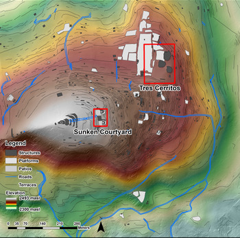
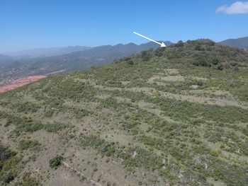
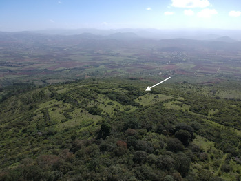
The Cerro Jazmín Archaeological Project excavated 10 different areas of the settlement to obtain chronological information about the city's occupational history and economic activities. We excavated at two monumental areas (Figure 2). The Sunken Courtyards sector is located near the hilltop, just below an east-facing access way that leads to the hilltop where we recorded a series of platforms that follow the ridge. Access to this sector requires walking uphill through dozens of terraces, although in pre-Hispanic times there might have been formal path to this area. This path would have necessarily crossed most of the western slope of the mountain, which was covered in residential terraces (Figure 3).
Location of the two monumental areas excavated at Cerro Jazmín and discussed in this article. Map by Martínez Tuñón.

Photograph of the hilltop of Cerro Jazmín and the more restricted location of the Sunken Courtyard sector. Photograph by Eli Pérez Matos.

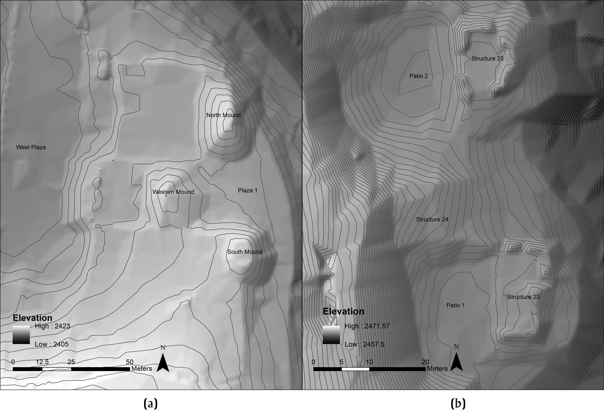
The second excavated area is the Tres Cerritos sector (Figures 4 and 5), which is located on the mid-northeastern slope of the mountain and is the most accessible area of the settlement (Neff Reference Neff2010). To reach this sector from the valley floor requires a moderate to strenuous hike and crossing scores of terraces on the lower slopes of the hill. Once inside the settlement, however, the Tres Cerritos sector is highly visible and accessible from the eastern and northern slopes along a long narrow terrace that was an intrasite pedestrian corridor or road. In addition, any sound made on top of the mounds can be heard across much of the northern slope of the site. The Tres Cerritos mounds are even visible from the valley floor and today they are well known to all in the surrounding communities. The view from this area is vast and spectacular, giving the viewer access to the northern Nochixtlan Valley, the ex-convent of Yanhuitlan, and the hill of Yucuita.
Topographic map of the excavated monumental areas. (a) Tres Cerritos and (b) Sunken Courtyards, showing the structures, mounds, plazas, and open areas discussed in the text. Map by Martínez Tuñón.

Photograph of the Tres Cerritos sector and its more accessible location on the northeastern slope of Cerro Jazmín. Photograph by Eli Pérez Matos.

The excavations conducted in the monumental sectors were to document their mode of construction and history of occupation. The stratigraphic excavations were initially spatially restricted to trenches. Later on, some of our operations expanded horizontally to obtain information about the areas’ spatial layout and function. In the Tres Cerritos excavations, our efforts focused on the heavily looted western mound and the adjoining eastern and western plazas to obtain a complete stratigraphic profile of the structure and learn about its construction and relationship to the adjoining plazas.
Sunken Courtyards
We presented the results of the Sunken Courtyards excavation in a previous publication (Pérez Rodríguez et al. Reference Pérez Rodríguez, Tuñón, Stiver Walsh, Roldán and Estévez2017a). Here, we summarize the most pertinent information and focus on the chronological evidence about the timing of the construction and use of this sector in relation to the Tres Cerritos sector.
Initial evidence of activity in the Sunken Courtyards sector dates to 261 ± 75 cal b.c. (UGAMS 15440) when we found a small, square, altar-like construction underlying what would later become Structure 23 (Figure 4). In the following century, between 147 ± 37 cal b.c. (UGAMS 15450) and 100 ± 39 cal b.c., two platforms were constructed, each flanking the eastern side of what would become Patios 1 and 2. Above these platforms, Structures 23 and 25 were constructed with stone foundations, wattle-and-daub walls, and thatched roofs. We found large circular firing pits or ovens in Structure 23 and evidence of feasting activity in Patio 1 during this time period. The associated faunal and ceramic evidence points to feasting activity where boiled and roasted dog, turkey, rabbit, and some deer meat were served in decorated bowls, 20 percent of which were fine tan wares or decorated gray wares similar to Valley of Oaxaca ceramics. Among the faunal remains, we also recovered a specimen of marine turtle.
On top of Structures 23 and 25, we recorded a layer of ash, which indicates a burning event that took place between 100 ± 39 and 14 ± 23 cal b.c. (UGAMS 15447). Above the ash layer we documented another occupation of continued feasting activity, but with different characteristics. Between 14 ± 23 cal b.c. and 44 ± 24 cal a.d. feasting continued, but rare marine species were absent, the amount of dog meat served increased, and the osteological evidence suggests that the meats were mostly boiled and no longer roasted. Feasting participants were served in relatively smaller bowls (comparing average bowl diameters between the two time periods), and among the serving vessels the percentage of locally made, yellow-paste channel-rim decorated bowls increased from six to 16 percent. We interpret these trends as indicative of changing feasting patterns: in the later feasting period, more people participated in feasts, but were served locally available meats prepared in a more homogenous manner and in relatively smaller, decorated bowl of local manufacture.
After 44 ± 24 cal a.d. there is little evidence of feasting in the Sunken Courtyards sector, although we documented the later reutilization of a cooking feature in Structure 23 and the addition of a wall on Structure 25 between 135 ± 41 and 353 ± 41 cal a.d. At this time, feasting activity in the Sunken Courtyards diminished and our excavations at other city sectors suggest that after 200 a.d. the city underwent a period of decline in which new construction ceased.
Previously, we proposed that feasting patterns shifted from an earlier (Early Ramos period), exclusionary strategy, in which status differences were accentuated in feasting events in which some people got to eat rare foods in Zapotec or Zapotec-style vessels, to a more communal form of feasting in the Late Ramos period (Pérez Rodríguez et al. Reference Pérez Rodríguez, Tuñón, Stiver Walsh, Roldán and Estévez2017a). The Zapotec-style vessels were G12-, G17-, and some G21-type bowls imported from the Valley of Oaxaca and other times they were locally made examples of these decorated fine gray-ware bowls (Caso et al. Reference Caso, Bernal and Acosta1967:25–35). In the second period of activity, and after the fiery destruction of the Sunken Courtyards structures, feasting continued, but with relatively simpler feasts that included more participants who were served simpler, locally available foods in locally made vessels. The Sunken Courtyards sector stopped being a feasting site sometime before the city's abandonment at the start of the Classic period, by a.d. 300.
Tres Cerritos
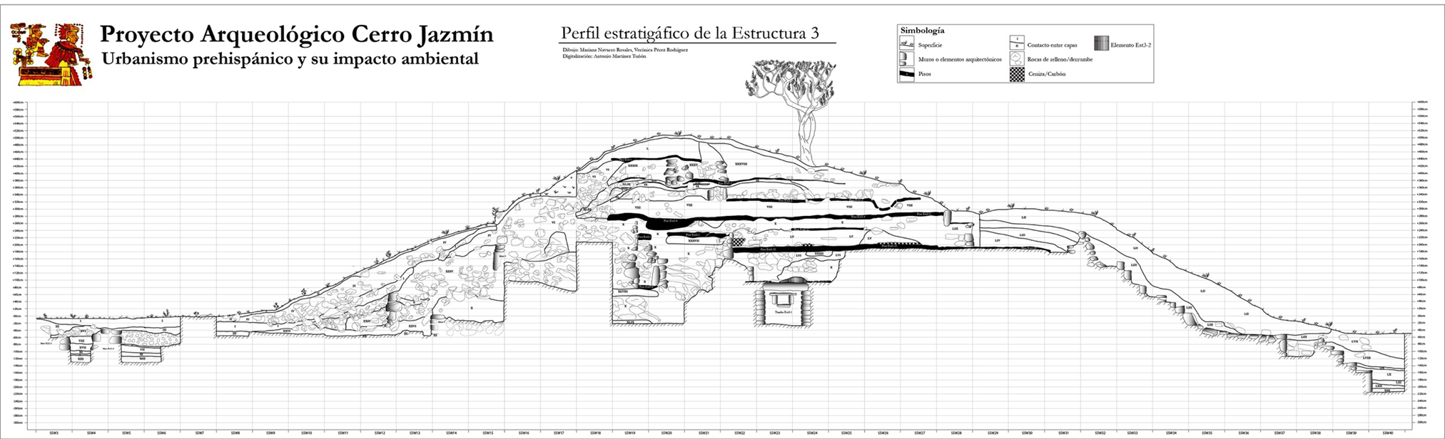
Our operations in Tres Cerritos focused on the western mound (Figure 4), which was looted in the 1930s. We obtained permission from Mexico's Consejo Nacional de Arqueología to dissect the structure from east to west following the crooked path of the looters to record a stratigraphic profile (Figure 6). We found that the mound had a formal façade and staircase facing west onto a flat area (30 × 34 m), a west-facing platform that descends onto a large plaza, the western plaza, that runs approximately 50 m east-west by 145 m north-south. Since the western mound appears to face the larger and more accessible western plaza and not the smaller and more restricted eastern Plaza 1, we currently think that this area may have actually been a more private space or patio. It is possible, however, that future excavations may find a formal access way to Plaza 1.
Stratigraphic profile of western mound excavations in the Tres Cerritos sector. Drawing by Pérez Rodríguez, Martínez Tuñón, and Mariana Navarro Rosales.

Explorations in the eastern Plaza 1 demonstrate that this space was used very early on in the city's occupation (for other radiocarbon dated contexts on the site's earliest occupations see Pérez Rodríguez et al. [Reference Pérez Rodríguez, Tuñón and Ponce de León2018:Table 1]), when the area was raised and leveled through the construction of stone-walled boxes that were filled to raise the terrain and create a higher and broader area. Large terrace walls, with 3-m tall formal façades to the east, contain these terrain-shaping constructions of walls, fill, and stone block layers. On the northern side, the retention wall façade underlies the northern mound, which sits 11 m high on its north and eastern slopes. A structure with a thatched roof was raised upon this flat space, as suggested by the post-mold feature and surrounding, stomped, earthen floor we uncovered. A radiocarbon date associated with the post mold suggests that the feature was filled with charcoal-rich matrix that had the calibrated date of 280 ± 63 cal b.c. (UGAMS 22049, all calibrated dates presented henceforth show their 1-sigma range; http://www.calpal-online.de).
Between 280 ± 63 cal b.c. (UGAMS 22049) and 219 ± 100 cal b.c. (AA105179), much effort was directed towards modifying the place that once housed the thatched structure to create an even higher and broader area that became Plaza 1. It measured approximately 24 (north-south) by 30 (east-west) meters and was formally delimited to the north and south by mounds that we have yet to excavate, to the west by the mound that is the focus of our current discussion, and to the east by a 3-m tall stone retention wall (Figure 4).
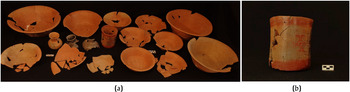
Based on radiocarbon evidence, we know that the structure at the core of the west mound was in use by 17 ± 36 cal. a.d. (AA105194). At the core of the mound, we uncovered the remains of a stucco floor (8) and a 2-m tall stone wall (6) with a western-facing façade, apparently the remains of an interior room whose floor (8) was at the approximate same elevation as the stucco Floor 13 that sat directly above a single-chambered tomb. Due to the damage done by the looters in the 1930s, we failed to recover any associated human remains or offerings from inside the tomb. The single-chambered tomb was not entirely symmetrical, but had four niches, one in each of the walls. Also, a deteriorated layer of stucco covered the walls and in a few small places red pigment was still visible. The tomb had four stone roof slabs, one of which was displaced during looting. Sitting directly above the southern portion of the roof, we recovered an offering that yielded the date of 17 ± 36 cal a.d. (AA 105194) and 19 vessels. Fourteen of them were high-fired, yellow-paste, conical bowls with decorated rims and some with decorated bottoms. We also found one yellow-ware cylindrical vase (24-cm diameter) and two yellow-ware, small water jugs with 8-cm rim diameters. These vessels are examples of the newly defined Tiltepec yellow ware that accounts for 37 percent of the Late Ramos ceramics and 60 percent percent of the Transition-period ceramics recovered from our excavations (Pérez Rodríguez et al. Reference Pérez Rodríguez, Tuñón, Stiver Walsh, Roldán and Estévez2017a, Reference Pérez Rodríguez, Tuñón, Minc, Walsh and Rosales2017b). There were also two vessels of the costlier fine brown ware; these were a small jug (9-cm rim diameter) with a fine and highly polished black slip and a cylindrical vase. The vase was decorated with a highly polished brown slip followed by a highly polished band of red paint along the rim and a series of four quadripartite motifs, painted in red on the exterior wall of the vessel (Figure 7).
(a) Ceramic vessels recovered from the tomb offering and (b) close-up of the fine-brown ware cylindrical vessel. Photographs by Mariana Navarro Rosales.

We sent five of these vessels to UNAM's Archaeological Prospection Laboratory at the Instituto de Investigaciones Antropológicas where Barba Pingarrón and Hernández (Reference Barba Pingarrón and Hernández2017) performed chemical residue analyses to identify carbohydrates, protein, and fatty acid residues (Barba Pingarrón Reference Barba Pingarrón2007; Barba Pingarrón et al. Reference Barba Pingarrón, Rodríguez and Córdova1991). Four of the five vessels were yellow-ware conical bowls and the fifth was the fine-brown cylindrical vase. The five vessels yielded high protein residue values of 9 and 8.5. Three of the yellow-ware conical bowls also contained high values of fatty acids, suggesting that they contained and absorbed oils, fats, or resins and protein residues possibly from animal protein-rich foods. In contrast, all five vessels yielded the lowest amounts of carbohydrate residues from among the Cerro Jazmín samples, which contained vessels from burial offerings recovered in household settings. The low carbohydrate values suggest that the vessels in the tomb offering did not contain carbohydrate rich foods like atoles or fermented drinks like pulque, but instead contained broths or other foods or offerings rich in animal protein.
The antiquity of the offering and the chemical residue data is especially telling when we consider that, while the offering was being made, evidence from other city sectors suggest that the city's governance was shifting. In the older and more restricted Sunken Courtyards sector, feasting continued but in ways that aimed to feed larger numbers of commensals that ate broths (made from locally available animals) that were served in smaller and locally made vessels. The importance of these feasts to the lives of the inhabitants of Cerro Jazmín is further reinforced by the isotopic data we have obtained from Formative-period human burials that suggest that the city's population ate a virtually vegetarian diet very high in C4 foods like maize (Pérez Rodríguez and Kellner Reference Pérez Rodríguez and Kellner2018). At the start of the Late Ramos period a highly ornate ceramic and food offering was placed on top of the tomb of a person or persons who enjoyed preferential treatment in death, as in life. While the city leaders were trying to outwardly communicate that they were adopting a more collective form of government that invested in the construction and use of larger, more accessible public areas, in private settings, this privileged sector of society still enjoyed greater access to fine goods and foods rich in animal protein. Unfortunately, we were unable to collect any human remains from the tomb to test through isotopic analysis if these dietary differences reflect in the bone chemistry of those buried in the mound. As we will elaborate in the Discussion section, however, the tense coexistence of these disparate sociopolitical strategies, one building communal identity while the other reinforcing social stratification, is perhaps a more widespread pattern across other contemporary Oaxacan polities.
The tomb and offering were covered by a 40-cm layer of fill topped by stucco Floor 10, which extended for 8.6 m east-west. Roughly associated with this floor on its western edge, we uncovered a staircase that connected the mound with the larger (50 × 145 m) and more public western plaza. Although this broader and very accessible public area has been impacted by mechanized agricultural activity in the last decades, the surface artifacts recovered represent the widest array of ceramic, lithic, and shell artifacts for the entire city. In the future we hope to test the hypothesis that this city sector could have functioned as a public place of trade and civic-ceremonial activity.
Heading back to the top of the western mound, sitting directly on stucco Floor 10, we recorded a high concentration of burnt debris that included friable and charred building stone and burnt lithic, ceramic, and bone artifacts in an ashy matrix. A charcoal sample from this feature suggests that a high-temperature burning event occurred in cal a.d. 122 ± 69 (AA 105192). After this fire, the builders reduced the east-west extent of the floored area above the mound, erecting west-facing wall 7 that left the western extent of Floor 10 exposed up to the start of the staircase, while raising the floor level for an additional floored structure by 20 cm. The new Floor 12 was only partially recovered, but was clearly separated from another area that is defined by a separate floor (3) which was located further east, thus indicating that the top of the mound was separated into two separate indoor floored areas.
In time, the top of the mound was raised again by 20–30 centimeters of fill that were topped by Floor 4, a very substantial stucco floor, which was again defined to the west by a wall façade of which only a single row of the stone foundation survived. Stucco Floor 4 was 5–10 centimeters thick and well-made. We retrieved a charcoal sample within it that we dated to cal a.d. 168 ± 44 (AA105189). The earlier division of space into two different floored areas on top of the mound, one east and another west, disappeared with the placement of Floor 4.
Above Floor 4, we recorded three additional stucco floor levels (floors 3, 2, and 1), each sitting 20 to 30 centimeters above the other. We were unable to collect reliable charcoal samples from these levels, but the ceramics recovered were a mixture of Late to Terminal Formative ceramics and, in the upper levels, Postclassic ceramics that included brazier and censer fragments. The placement of Floor 3 suggests that the top of the mound was again divided into two spaces, one facing east and another facing west, with a centrally located wall that ran approximately north-south. Stucco Floor 3 also included a formal channel drain feature that ran along the western top edge of the mound in a north-south direction. This feature acted as a channel that diverted rainwater. Roughly 30 centimeters above Floor 3 the ancient builders raised the top of the mound again, and placed a thin layer of stucco, Floor 2, which acted like an exterior porch to a structure that had an interior marked by Floor 1. The interior room sat 20 centimeters above and west of a stone wall that ran north-south and continued the now-established pattern of dividing the space above the mound into east and west areas. Based on the associated artifact evidence, these more recent occupations and floors were possibly used in the Postclassic period, when Cerro Jazmín grew again in regional importance and population.
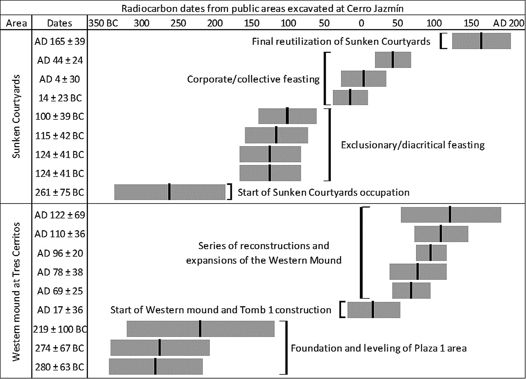
Overall, it appears that the most important period of construction of the western mound occurred in the Late Ramos period, between the construction of the tomb and the placement of Floor 4, between 50 b.c. and 200 a.d. This time frame corresponds with the political shift we believe occurred and prompted the reorganization of feasting in the Sunken Courtyards sector and the investment in more accessible public areas (Figure 8).
Graph showing the calibrated radiocarbon dates for periods of use and construction at the Sunken Courtyards and the Tres Cerritos sectors. All dates shown were calibrated with http://www.calpal-online.de and show 1-sigma ranges in gray.

DISCUSSION
We compared the radiocarbon dates obtained from the Sunken Courtyards and Tres Cerritos excavations (Figure 8) and found that, although the two monumental areas were at times used contemporaneously, the timing of their initial construction and their main periods of growth and activity point to a shift as to where monumental construction and civic-ceremonial activity was focused at different periods in the city's occupation.
In the first centuries after the settlement was first founded between 300 and 100 b.c., monumental construction and ritual activity concentrated in the smaller and more restricted monumental sector of the hilltop and the nearby Sunken Courtyards area. Also in use was a thatched structure that was built in an area that would later become the plaza at the center of the three mounds of Tres Cerritos. At this time, feasting evidence in the Sunken Courtyards suggests the adoption of a more exclusionary sociopolitical strategy that emphasized the elevated status of a small sector of the population, rulers, and elites. We believe a sociopolitical transformation occurred around 100 b.c. The structures in the Sunken Courtyards area were burned, while the Tres Cerritos sector became more formally defined and monumentally constructed. Although we recorded evidence of land modification and activity in the place that would become Plaza 1 in Tres Cerritos since 280 ± 63 b.c., no formal stone construction, beyond the construction of retention walls, was recorded until the start of the Late Ramos period (by 50 b.c.).
As more collective feasting patterns were adopted in the Sunken Courtyards sector, there was greater investment in building the more open and accessible Tres Cerritos area, including large open plazas directly to the south and west of the west mound of Tres Cerritos. Not only is the Tres Cerritos sector much more accessible and better connected, but its facilities, the adjoining plazas, are able to accommodate larger numbers of people. The expansion and construction of the west mound continued and intensified between a.d. 50 and 200, when feasting appears to have largely stopped in the Sunken Courtyards sector.
We propose that in the Late Ramos period the bulk of public civic-ceremonial activity shifted from the areas near the hilltop to the Tres Cerritos sector and the adjoining plazas. We are uncertain, however, of the kinds of activities that took place at this more open and accessible location. To fill in the picture, we interpret the available surface survey data. Surface materials collected from the Tres Cerritos sector and the areas directly south and west of the mounds contained the most varied array of artifacts and raw materials. In terms of lithics, this area offered examples of all kinds of raw materials, high- and low-quality chert, obsidian, and even large chunks of quartzite. In addition, the lead author noted the presence of unusually long obsidian blades during her initial survey of Plaza 1 during a regional survey conducted in the Nochixtlan Valley (Kowalewski et al. Reference Kowalewski, Balkansky, Stiver-Walsh, Pluckhahn, Chamblee, Rodríguez, Heredia Espinoza and Smith2009). All the existing ceramic types ever recorded at Cerro Jazmín were found in the Tres Cerritos area surface collections, along with a few examples of shell fragments. The diversity of the surface materials found and the area's accessibility make it a strong candidate for the location of a market in the city (Shaw Reference Shaw2012). A full exploration of this hypothesis would require a larger program of excavation, which we hope to undertake in the future.
Sociopolitical Strategies Across Late and Terminal Formative Oaxaca
Research into the sociopolitical strategies employed at other Late and Terminal Formative communities across Oaxaca help complete the picture on how these polities built and maintained their power. In the Valley of Oaxaca, conflict and warfare have long been thought to be the primary factors that drove the establishment of Monte Albán in a defensive and neutral location (Blanton Reference Blanton1978; Marcus and Flannery Reference Marcus and Flannery1996:139–154; Spencer Reference Spencer2010). Once the settlement was established, however, the architecture and monuments erected in the centuries that immediately followed have inspired scholars to interpret them as evidence of the establishment of the inalienable power of ruling lineages and individual rulers, or the works associated with the constant negotiation of authority through communal forms of ritual and public engagement (Joyce Reference Joyce2010:141–146; Marcus and Flannery Reference Marcus and Flannery1996:158).
Even consolidating Monte Albán's regional power was not an immediate achievement, as nearby polities actively resisted Zapotec expansion, while other regions further afield, the Cuicatlan Cañada and the Sola Valley, were incorporated sooner (Sherman et al. Reference Sherman, Balkansky, Spencer and Nicholls2010). Research in the south-central part of the Oaxaca Valley, at San Martín Tilcajete, has revealed a protracted process where Monte Albán's territorial control grew in a mosaic fashion (Spencer and Redmond Reference Spencer and Redmond2001). At the Late Formative-period site of El Mogote (300–100 b.c., Late Monte Albán I or Pe phase), the Tilcajete polity retained its autonomy, even while suffering the consequences of obsidian trade disruption or obstruction. By the Terminal Formative period (100 b.c.– a.d. 300, Monte Albán II or Nisa and Tani phases), however, Tilcajete fell under Monte Albán rule, as indicated by a settlement shift to the site of El Palenque and the presence of ceramic types and obsidian that had formerly been absent in the area (Elson Reference Elson2003; Redmond and Spencer Reference Redmond and Spencer2012; Spencer and Redmond Reference Spencer and Redmond2003, Reference Spencer and Redmond2004).
In the Lower Río Verde region, on Oaxaca's Pacific Coast, colleagues working at the Late Formative sites of Cerro de la Cruz, Yugüe, and Río Viejo report evidence of modest, yet increasing social differentiation along with engagement in public activities that sought to solidify collective identities at the expense of individual expression (Barber et al. Reference Barber, Workinger and Joyce2013). At Cerro de la Cruz and Yagüe, Joyce (Reference Joyce2010:183) and Barber (Reference Barber2005), respectively, documented the use of public cemeteries where adults were interred with no associated offerings in areas near or underneath prominent parts of the settlement. At the sites of Río Viejo and Yugüe, Joyce and Barber, respectively, also found evidence of communal feasting activities. In the case of Yugüe, feasting foods consisted of the locally available estuarine mollusks locally known as tichinda (Barber Reference Barber2005:98; Joyce Reference Joyce2010:183). Other colleagues working in the area have suggested that the very act of construction of public works may have served to solidify communal identity, as was the case in the construction of the massive acropolis at the center of the site of San Francisco Arriba (Workinger Reference Workinger2002:171–222).
By the Terminal Formative period, Río Viejo had grown in size and complexity to become the area's first urban center. Much like the case at Cerro Jazmín, researchers have found evidence at Río Viejo of the fragile coexistence of two different and conflicting dynamics: the accentuation of societal differences, to the point of stratification, and the continuation of public practices aimed at consolidating a communal ethos.
As both the Valley of Oaxaca and Lower Río Verde examples illustrate, political power of early regional centers and eventually urban centers across Oaxaca was hard-fought, negotiated, and sometimes actively resisted. As we noted in previous publications, ceramic inventories from Late and Terminal Formative contexts at Cerro Jazmín suggest a move away from gray-paste, Valley of Oaxaca decorated bowls and G12 and G17 vessels, and a move towards using more locally made, yellow-paste, decorated bowls (Pérez Rodríguez et al. Reference Pérez Rodríguez, Tuñón, Minc, Walsh and Rosales2017b, Reference Pérez Rodríguez, Tuñón, Minc, Walsh and Rosales2017c). This material reflection of how the polity resisted or reduced the prominence of materials from the Valley of Oaxaca, and arguably, their associated political influence, in favor for more local goods has also been noted by our colleagues working in the Valley of Oaxaca and coastal Oaxaca. For example, Joyce (Reference Joyce2010:187) interprets the decline of Valley of Oaxaca ceramics and central Mexico obsidian at Terminal Formative Coastal sites as a result of disrupted exchange routes brought out by conflict among highland polities. In the Tilcajete area of the Valley of Oaxaca, Spencer et al. (Reference Spencer, Redmond and Elson2008) note the local manufacture of G12 vessels and the absence of cream-paste vessels during the time when the polity resisted incorporation into the Monte Albán state and then the presence of cream wares in the area after their incorporation (Elson and Sherman Reference Elson and Sherman2007). Whether these patterns were a result of trade disruption or political choice, it seems clear that power and political autonomy were constantly negotiated within communities and across regions in Late and Terminal Formative Oaxaca.
CONCLUSION
We argue, based on chronological, architectural, and artifact data obtained from two monumental sectors of Cerro Jazmín that the urban center experienced a sociopolitical shift between the Late Formative (Early Ramos) and the Terminal Formative periods (Late Ramos). This shift consisted of the city's governance and society moving away from exclusionary sociopolitical strategies in the Early Ramos period to a more collective form of organization in which status differences were outwardly suppressed in favor of a more collective identity. In undergoing this shift the city's spatial configuration changed. Civic-ceremonial activity and monumental construction shifted from a smaller and spatially restricted area near the hilltop, the Sunken Courtyards sector, to the larger, more open, and accessible monumental area of the Tres Cerritos sector.
The data presented supports previously published finds that suggest the same sociopolitical shift, and the timing of this shift, based on a change in the feasting patterns identified in the Sunken Courtyards sector (Pérez Rodríguez et al. Reference Pérez Rodríguez, Tuñón, Stiver Walsh, Roldán and Estévez2017a). Although we are unable to speak to the causes behind this shift, it appears that the initial sociopolitical exclusionary strategy that was employed by the city's rulers and elites grew either unpopular or ineffective for governing the city in the later part of the Early Ramos period. Perhaps the flexibility to change social and political strategies and ideas contributed to the city's resilience and its survival into the Late Ramos period. As a result, this primate urban society enjoyed approximately 600 years of continuous occupation. Unfortunately, the political fortunes of the city and its rulers changed again for the worse when the city was partially abandoned by the start of the Classic period.
RESUMEN
Presentamos datos de excavaciones realizadas en dos áreas monumentales que formaron parte de la traza urbana de Cerro Jazmín, un centro urbano preclásico (300 a.C. a 300 d.C.) ubicado en la región mixteca de Oaxaca, México. Con nueva información estratigráfica y fechamientos de radiocarbono argüimos que la traza urbana y la cronología de cómo las dos áreas monumentales fueron construidas y utilizadas en el preclásico tardío (300 a.C.–100 d.C.) y el preclásico terminal (100–300 d.C.) apuntan a un cambio en la estrategia política de quienes gobernaron la ciudad. Inicialmente la actividad cívico ceremonial se enfocó en un área más restringida cerca de la cima del cerro y un sector llamado los Patios Hundidos (Sunken Courtyards) donde registramos evidencia de festines, los cuales cambiaron de modalidad entre las dos épocas mencionadas. Por otro lado, un área monumental más accesible, los Tres Cerritos, tuvo un crecimiento importante en el preclásico tardío cuando detectamos una serie de etapas constructivas que apuntan a su crecimiento y uso. Pensamos que los gobernantes de la antigua ciudad inicialmente usaron estrategias políticas exclusionarias durante la primera etapa de ocupación de la ciudad en el preclásico tardío cuando hubo festines más exclusivos cerca de la cima. Posteriormente, en el preclásico terminal, optaron por una estrategia política que buscaba proyectar una ideología más colectiva que se reflejaba en la construcción y uso de espacios públicos más accesibles y más amplios. Eventualmente, detectamos un cese en la construcción de espacios monumentales y un declive poblacional (más no un abandono total) durante la época clásica. Aunque el sitio fue reocupado en la época posclásica, este artículo se enfoca únicamente a la ocupación preclásica de Cerro Jazmín.
ACKNOWLEDGMENTS
National Science Foundation grants #0742815 and #1116380 funded the mapping, survey, and excavations at Cerro Jazmín, which are the basis of the data reported in this article. We thank Mexico's National Archaeology Council and INAH, the National Institute of Anthropology and History, for the research permits awarded and their institutional support. We are thankful for the trust and collaboration of the authorities and local community members of Santa Maria Tiltepec. We thank our families, especially our kids, for their enthusiasm and support of our work. Finally, we thank our reviewers whose thoughtful comments allowed us to improve this manuscript.