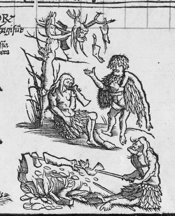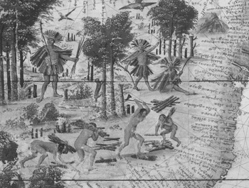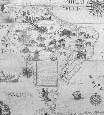


To European readers of contemporary travel writing in the first half of the sixteenth century, the region they had come to know as Brazil was a land of ferocious cannibals. Early German printed travel editions, geographical works, and maps were instrumental in circulating graphic vignettes of cannibal butchers dismembering their victims, hanging limbs from rooftops, and roasting body-parts on spits. An influential example was Martin Waldseemüller's Carta marina of 1516 (Figure 1).Footnote 1 Such depictions of cannibalism in Brazil appeared on over sixty out of around seventy maps and atlases containing representations of Brazilians that were produced in Portugal, Spain, France, Germany, and the Low Countries between 1500 and 1625.Footnote 2 The motif was the earliest for a New World people to appear on maps, and was by far the most prevalent.Footnote 3
Martin Waldseemüller, Carta marina (Strasbourg, 1516), detail from north-east South America. Image courtesy of the Jay I. Kislak Foundation and the Library of Congress.

In the light of such evidence, a complaint made in the 1530s by the Norman poet and navigator Pierre Crignon might seem surprising: ‘If the king would but loosen the bridle on French merchants, in less than four or five years they would win for him the friendships and ensure the obedience of the Brazilian natives without other arms than persuasion and good conduct.’Footnote 4 Crignon was frustrated by the policies of François I of France limiting French access to Brazil – a region claimed by the Portuguese crown. To Crignon, were François to permit the French – in particular, Norman sailors – to travel to Brazil, they would be able to trade successfully with the indigenous Tupinambá.
What was the basis for Crignon's assertion? It is unlikely that his complaint was merely an empty promise – he had already been to Brazil, and would presumably not have wished to send his countrymen to cannibal cooking-pots for want of proper preparation and caution. Nor was he alone in his opinion. Crignon's view of the Tupinambá as amenable trading partners is echoed across Norman visual culture, from stained-glass windows to pieces of sculpture and, in particular, on illuminated Norman manuscript maps. The peaceful iconography on Norman maps (Figures 6–7) contrasts sharply with that found in other European cartographic traditions. It also differed from the illustrated maps circulating in sixteenth-century France more generally, many of which originated outside France. As the Huguenot traveller Jean de Léry noted, mapmakers ‘in their maps of the world, have not only represented and painted the savages of the land of Brazil roasting human flesh on a spit, as we cook mutton joints and other meat … but also cutting it with great iron knives on benches, and hanging the meat up for display, as our beef butchers do over here’.Footnote 5
The differences between Brazilians represented in Norman nautical circles (i.e. among mapmakers and travellers) and those depicted in other traditions prompt questions about the construction, circulation, and interpretation of knowledge about distant regions. Renaissance map illustrations have received little serious scholarly attention. Although it has been rightly suggested that the illustrations on Norman maps reflected French trading experiences, the images have not been analysed alongside contemporary textual descriptions.Footnote 6 Several questions remain to be answered. What relationships existed between Norman cartographic imagery and the genre of travel writing? To what extent was the imagery based on widely circulating sources of the type consulted by Portuguese, German, and Dutch mapmakers? To what extent were their unusually peaceful depictions of Brazilians informed by local economic and political agendas, rather than by realities (perceived or otherwise)? How did these ornate and expensive artefacts, often given as gifts, function within the culture of gift-exchange? This article addresses these questions and seeks to rethink the methodology for approaching the iconography of maps in relation to the complex interplay between cultural encounters, trade, and Atlantic empires.
It is important to clarify certain points of terminology at the outset. ‘Brazil’ in this article includes, but also exceeds, the boundaries of modern Brazil. The term covers the Amazonian basin and the northern and eastern coasts of South America between the Amazon and Rio de la Plata estuaries. The term was first used in early sixteenth-century Portuguese sources. I use the term ‘Brazilian’ sous rature to refer to the region's peoples as a whole, since what is under study here is the process by which emblematic characterizations of the region's inhabitants emerged on maps and subsumed their distinctive practices. In practice, these peoples belonged to some forty distinct language families. Many belong to one of three main groups: Tupi-Guaraní, Arawak, and Macro-Gê.Footnote 7 Where interaction with particular peoples is under discussion, I use more specific terminology. Travellers and geographers themselves had difficulty distinguishing between local populations with different languages, territories, practices, and cultures, and with historical changes to these societies.Footnote 8 When referring to particular source texts and maps, I deploy their own terminology while attempting to identify the people they were encountering. The collective term ‘Tupi’ refers to various Tupi-Guaraní-speaking tribes. These included the Tupinambá, who lived in coastal Brazil and encountered Norman traders in the mid-sixteenth century.Footnote 9
I
In the first half of the sixteenth century, Normandy was a centre of long-distance trade. The prosperous port city of Dieppe, where the majority of Norman mapmakers were based, had the largest share of maritime commerce in Normandy, perhaps in all of France.Footnote 10 Trans-oceanic traders required ships and navigational aids including maps, fuelling further local enterprise. For Norman ports, long-distance trade was a ‘key industry’ in the Braudellian sense: the health of a number of activities, from cloth-making to cartography, spice trading to ship-building depended on the continuation of direct trade with Brazil and the East Indies.Footnote 11
Brazil was of particular economic importance, supplying such commodities as brazilwood, cotton, pearls, parrots, and monkeys. A red pigment extracted from brazilwood was used by cloth- and tapestry-makers in Normandy and Flanders. It was cheaper and of better quality than the pigment that was shipped from the Far East via a much longer journey.Footnote 12 In the second half of 1529 alone, 200 tonnes of dyewood were unloaded at Honfleur.Footnote 13
The patterns of sponsorship of French trade differed from the state-sponsored paradigm that operated in Spain and Portugal. The Treaty of Tordesillas (1494) signed by the Iberian powers, and based on papal bulls, divided the world between them.Footnote 14 On this basis, they attempted to monopolize trade and settlement in those parts of the Americas, Africa, and Asia reached by oceanic voyages. At first, the French did not object, but in 1536, François I sent an envoy to Pope Clement VII asking for an arbitration. Clement decreed that Pope Alexander VI's earlier bull applied only to the known lands and not to those discovered later by other nations. This freed French explorers to claim parts of America, albeit without Iberian approval.Footnote 15 Nevertheless, during much of this period, voyages leaving Norman and Breton ports had little royal support.Footnote 16
Continuous diplomatic pressure on the French crown from the Iberian monarchs meant that the impetus behind French exploration and maritime politics came not from the court in Paris, but from private sponsors – merchant ship-owners and outfitters known as armateurs.Footnote 17 Early forays in Brazil and Guinea convinced them that trade rather than colonial establishment was the most profitable enterprise for their agents.Footnote 18 Thus French voyages had different objectives from Iberian ones, favouring quick profits over long-term colonization. Among the ship-owning dynasties, the Ango family was probably the most active in Dieppe. Jean Ango the Younger, the family's best-known scion, financed numerous expeditions to the Americas and the Far East.Footnote 19 He was appointed lieutenant to the admiral of France in 1536.Footnote 20
The king's goodwill was of paramount importance to Norman armateurs. From the point of view of their Portuguese rivals, Norman merchants could not lawfully trade in Brazil. The Portuguese crown did not approve of what it perceived as interlopers in its territory. It attempted to restrict French incursions into Brazil through a combination of diplomatic activities, sanctioning attacks on Norman trading ships and bribing French officials and even armateurs. Portuguese forces and French privateers frequently engaged each other in battle, both at sea and in Brazil. Reparations for subsequent losses formed part of the benefits each side sought through diplomatic channels.Footnote 21 François I was also pressured by the armateurs themselves, who desired unimpeded trading opportunities. The king needed their financial support in his intermittent war against the Emperor Charles V.Footnote 22 The armateurs knew that this gave them bargaining power – as did the riches they obtained through trade and piracy. Jean Ango, for instance, presented those who helped him with gifts from these enterprises. In 1529, he presented François's admiral Philippe Chabot with ‘a magnificent diamond’ in exchange for a letter of marqueFootnote 23 allowing him to collect compensation (by force) for his losses to the Portuguese fleet.Footnote 24 When the Portuguese heard of this, they in turn bribed Chabot to curtail French expeditions, presenting him with 25,000 écus, a tapestry worth 10,000 écus, and 16,000 francs.Footnote 25 Henri II, on his ascent to the throne, was equally fickle, issuing letters of marque and withdrawing them whenever he wished to switch allegiances.Footnote 26 In 1549, Henri granted Rouen a monopoly of 208 commodities, limiting importation of brazilwood to that city and to Marseilles.Footnote 27 This spelled the ruin of many Dieppois merchants; Jean Ango died penniless.Footnote 28 The economic lives of the armateurs who had invested heavily in ships and equipment, the purveyors of nauticalia, the pilots, cartographers, and sailors of Normandy swung regularly from boom to bust. The Normans’ Brazilian project was a lucrative but vulnerable one, a private enterprise, but one dependent on state approval. The iconography of Brazil on Norman maps needs to be interrogated in the context of the crucial part played by the brazilwood trade in the local economy, particularly in the maritime world of Dieppe's mapmakers.
Although a range of sources corroborated representations of Brazilians on Norman maps, it is important to consider the ways in which particular choices made by the mapmakers might have been shaped by local economic and political contexts. A world map made by Pierre Desceliers in 1550 contains the arms of Henri II, of Anne de Montmorency, constable of France, and of Claude d'Annebaut, admiral of France. Their presence suggests that the map may have been a political gift to the king from Montmorency and Annebaut.Footnote 29 Norman activities in Brazil were dependent on the goodwill of all three offices. Annebaut's predecessor, Philippe Chabot, had loomed large in the minds of the Gonneville expedition. When the crew erected a cross in Brazil, they inscribed it with the names of the pope, the king, ‘Monseigneur l'Amiral de France’, and their captain.Footnote 30 The navigator Pierre Crignon dedicated his Perle de cosmographie to Chabot in 1534.Footnote 31 Montmorency was a close adviser to and favourite of Henri. It was Montmorency's cousin, Admiral Gaspar de Coligny, who sent a colonizing mission to Brazil in 1555.Footnote 32
Henri's arms also appear on two other Norman works. The anonymous and undated manuscript known as the Hague Atlas bears three coats of arms: the royal arms of France; the arms of Henri II while he was the dauphin or heir apparent to the throne; and a partly covered escutcheon, possibly of the queen, with a crown discernible at one end. Each map also carries Henri's symbol, a fleur-de-lys, pointing north, and a crescent moon – the symbol of Diane de Poitiers – in the south. Since Diane officially became la dame du dauphin in 1540, the atlas must have been produced no earlier; the geographical features suggest a date of c. 1545.Footnote 33 The anonymous Harleian planisphere appears to have been given the arms of the Dauphin Henri in the first instance. These were later changed to the arms of the king, suggesting that the map was completed around the time of Henri's accession to the throne.Footnote 34
Norman maps participated in the economies of gifts and artworks. Natalie Zemon Davis's study of modes of gift-giving has revealed their wide-ranging use in the building of bonds between people and groups in sixteenth-century France.Footnote 35 More generally, Marcel Mauss, in his groundbreaking study of gifts in traditional societies, showed how gifts place obligations of reciprocity on the recipient; thus, far from being free, gifts form part of a cyclical system of exchange of things as symbols of honour and regard.Footnote 36 Both Davis and Mauss note how gifts can go wrong: gifts to sixteenth-century French officials were sometimes denounced as bribes; among Native American tribes of the Pacific Northwest, the escalation of competitive gift-exchange could lead to violence.Footnote 37 What, then, was the significance of giving an expensive, highly illustrated map as a gift to Henri II? And to what extent might the depiction of Brazilians on such a map have been informed by this gift-giving context?
Large, illuminated manuscript maps and atlases that were given as gifts embodied artefactual, intellectual, and political value. As expensive, decorative objects made by skilled artisans, they were status symbols that signalled the education and taste of those who commissioned and owned them. Their rarity and value indicated the high regard held by the donor for the receiver. Maps were also intrinsically intellectual artefacts. In the sixteenth century, they gave viewers a synthesized overview of a fast-changing world-picture, incorporating new information about numerous parts of the world. The political implications of the shape of the world meant that this world-picture was contested rather than fixed. Territorial claims made by a map's contents could hint to a recipient the ways in which the donor could give them control over desirable regions. Norman illuminated maps did not merely provide knowledge and political spin; the knowledge they gave about Brazil itself represented another gift-in-process: French access to dyewood, and to an empire of trade if not of territory.
Norman maps constituted both intellectual and political capital. In this sense, they were what Mario Biagioli, writing about Galileo's telescopes, termed ‘instruments of credit’: both physical apparatus and ‘techniques he used to maximize the credit he could receive from readers, students, employers, and patrons’.Footnote 38 Norman maps accrued credit as obligation, representing the gifts given to France by the Norman armateurs. What the maps’ emphasis on the dyewood trade presented to Henri II was the promise of continued commercial riches. It is significant that the three maps and atlases that bear his coat of arms date between 1545 and 1550, the years immediately before and after his accession to the throne. Such gifts were a means of building a personal connection between a client and a new royal patron. The image of Brazil as a fertile and peaceful territory where French traders and Brazilians co-operated to collect dyewood, despite the presence of cannibals, was an intellectual construction, a selective crafting of information based on experience. They presented the Norman Brazil trade as a source of valuable income – one that François I had already drawn upon when the need had arisen. Implicitly, the armateurs were donors to the king, not diplomatic embarrassments who complicated his dealings with Portugal. The map exhibited the skills of its maker and also created links of obligation between its recipients, makers and donors. Just as Galileo construed Jupiter's moons as the ‘Medicean Stars’ in order to build a connection with his desired patron, the presentation of Brazil on Norman maps highlighted a web of royal obligations to the Norman maritime world. Both the Medicean stars and Brazilian iconography, were, to use Biagioli's words, ‘not discoveries in the modern sense of the term’, but rather constructed objects ‘that, while displaying some of the features of our notion of scientific discovery, also participated in the economies of artworks and monuments’.Footnote 39
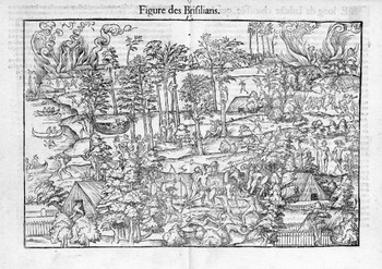
The importance for Norman port cities of establishing a royal connection is demonstrated by the pageant organized for Henri II's royal entry into Rouen on 29 September 1550. One vignette presented a scene of a Brazilian village. Fifty Brazilians from Bahía came to Rouen, allegedly of their own free will, to participate in the celebration (Figure 2).Footnote 40 They were joined by 250 naked French sailors who were acquainted with Brazil, their bodies painted black and red. Both the Amerindians and their French emulators enacted Tupinambá village life along the banks of the Seine, their activities mirroring those in contemporary travel texts and maps. The Tupinambá chopped, carried, and bartered wood in exchange for metal implements such as chisels, hatchets, and fishhooks. That the very trees were painted red illuminates the strong association between dyewood and Brazil which the organizers expected in the minds of the spectators, particularly Henri II. Other participants lay in hammocks or stalked birds and animals with bows and arrows. The climax was a mock battle between the Tupinambá and the Tabajara (enemies of the Tupinambá who had good relations with the Portuguese), ending with the defeat of the Tabajara and the incineration of the Portuguese fortress.Footnote 41 At the same time, a Portuguese corsair attacked a French ship anchored on the Seine near the Brazilian village. The portrayal of the Portuguese as the aggressors was of course partisan, since French ships also raided the Iberian fleets. A contemporary manuscript depicts boats near the island on the Seine that represented Brazil; the oarsmen bear shields emblazoned with the arms of France and of the admiral, Claude d'Annebaut.Footnote 42 All of these scenes would have been familiar tropes to viewers already acquainted with Norman manuscript maps, including Henri II. When Henri was dauphin, he was already in possession of the Hague Atlas and the Harleian map, both of which depicted woodcutters in Brazil, as we shall see.
Brazilian tableau at the entry of Henri II into Rouen, 1550 in C'est la déduction du sumptueux ordre (Rouen, 1551), sigs. K.ii.v–iiir, Typ 515·51·272, Houghton Library, Harvard University.

The Rouen entry graphically demonstrated the riches of Brazil: animals; parrots and other birds with fantastic plumage; monkeys with fine pelts; edible, pharmacological, and other plants; and, of course, dyewood. Many of the birds and animals had been loaned from the collections of the local bourgeoisie, another indication of the cultural impact of Brazil on Rouen. Some of the organizers were either participants in overseas trade or relatives of those who were.Footnote 43 Although descriptions of the entry show that it featured many of the elements found on maps that pre-date it, it is compositionally distinct from them; and they, in turn, are distinct from one another. The Brazilian mis-en-scène may have been staged in appreciation of Henri's decision, the previous year, to grant Rouen trading privileges.Footnote 44 It is likely that the event was intended to further the concerns of Rouen's mercantile community. Henri would later rescind the existing edict outlawing French voyages to Portuguese possessions.Footnote 45 In addition, the royal entry could well have played a part in convincing Henri to send a colonization party to Brazil – Villegagnon's expedition of 1555–6.Footnote 46
Both the iconography of Norman maps and the Rouen entry are examples of gifts that offered their donors, to an extent, the potential to subvert the patronage relationship to their own ends. Michael Wintroub has shown how the organizers of the Rouen entry, in common with those of other royal entries, tried to dictate subtly the terms of the city's relationship with the new king, and to offer a moral mirror, in the form of a series of tableaux, of the kind of king they wished him to be.Footnote 47 Such gifts were persuasive artefacts; their content needs to be interpreted in relation to the agendas of their donors. One might go so far as to suggest that the Norman Brazil enterprise prompted much wider cycles of gift-exchange, of which illuminated maps formed a part. The armateurs gave France Brazil and helped to pay for its wars against Spain. Indeed, Ango was partially ruined by his contributions to François I's war effort.Footnote 48 Norman maps were gifts that drew attention to the armateurs’ gift, and encouraged reciprocal gifts in return in the form of letters of marque to the armateurs. These letters allowed the armateurs to continue trading in Brazil and to board Portuguese ships, thus facilitating future gifts to the French king. The Portuguese did not stand passively by, but offered their own political gifts through diplomatic channels, as well as outright bribes. The Norman Brazil project had a peculiar dependency on fickle royal views about its political value. The armateurs were in direct competition with the Portuguese crown for the favour of the French kings. The legality of their actions at a particular time depended not only on their own relationship with the king, but also with his wider political needs. For example, at times when he was not at war with Spain, he did not need the money the armateurs could provide for outfitting his army. The French king thus partook of two different gift-giving/diplomatic circles around which the onus of obligation passed from group to group in a ‘pass-the-port’ fashion. The desirability for the king of one port-bottle over the other determined the speed at which he reciprocated the gifts made to him. Ultimately, Norman gift-giving was only partially successful.
II
The Norman school of cartography flourished between the 1540s and 1580s, with the majority of surviving illustrated works dating between 1540 and 1550. Over 250 Norman maps survive in the form of atlases, planispheres (single-sheet world maps), and maps within manuscript cosmographies and portolans (books of sailing directions). They comprise a total of thirty-seven discrete works or collections.Footnote 49 Twelve contain ethnographic images. Seven of these pre-date the first French attempt to set up a colony in Brazil in 1555–6. They also pre-date the influential illustrated narratives by Hans Staden, André Thevet, and Jean de Léry. These seven maps and atlases are the subject of this article. The three works offering the most extensive treatments of Brazilian ethnography form the focus: the Rotz Atlas (1542), the Vallard Atlas (1547), and the Desceliers planisphere or world map (1550).Footnote 50 These examples, analysed comparatively against travel writing and the Norman political and economic context, allow us to reconstruct what their Brazilian imagery might have signified to contemporary viewers.
In order to ascertain the impact of economic and political concerns on the Brazilian images of Norman maps, we must first establish how the images compare to the iconography of other maps that were available to Norman mapmakers, and the extent to which the Norman iconography was derived from contemporary travel writing on Brazil. We know little about the Norman cartographers themselves. Some came from Dieppe; indeed, Norman maps of this period have historically been described as the ‘Dieppe School’ of cartography.Footnote 51 These maps are manuscript rather than printed works, and relied heavily on Portuguese charts for their topographic features.Footnote 52 The cartography of the works known as the Rotz, Hague, and Vallard atlases was probably based directly on Portuguese examples.Footnote 53 The French obtained Portuguese maps through purchase and via capture; French pirates blockaded routes to Iberian ports on occasion, boarding and raiding ships.Footnote 54 In addition, some Portuguese mapmakers settled in Normandy.Footnote 55 The cartographers of the Hague and Vallard atlases may themselves have been Portuguese.Footnote 56
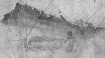
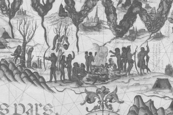
The relationship between the ethnographic illustrations in the Portuguese and Norman traditions, however, is far less clear. Eight surviving Portuguese manuscript maps and atlases place cannibalism or woodcutting in Brazil.Footnote 57 Of these, four examples illustrated Brazil exclusively with cannibalism. These include the Kunstmann II map (c. 1502–6), the earliest map depicting inhabitants of the Americas (Figure 3), and three atlases by Diogo Homem.Footnote 58 Diogo Homem's 1558 atlas shows the body parts hanging from trees and the spit-roasting limbs that were associated with the region of Brazil (Figure 4).Footnote 59 The nearby caption informs us that ‘cannibals eat human flesh and fight with poisoned arrows’.Footnote 60 A fifth example is the 1529 Weimar planisphere, the work of Diogo Ribeiro, who was based at this time at Seville, at the Casa de la Contratación. This notes that the people of Brazil ate their enemies’ flesh, but also that they would transport brazilwood to European ships for trifles.Footnote 61 The sixth, the 1519 Miller Atlas, describes the Brazilians on a text cartouche as human flesh-eating savages. The illustrations focus on depicting them chopping wood, but a small fire in the northeast corner seems to show cannibal cookery (Figure 5).Footnote 62 The seventh work, Pero Fernandes's c. 1545 map, depicts a woodcutter in northern South America.Footnote 63 The eighth, a map of the Atlantic drawn by Sebastião Lopes in 1558, depicts one figure in Brazil, peacefully chopping wood.Footnote 64
Kunstmann II map, c. 1502–6, detail from the east coast of Brazil. Cod. icon. 133. Bayerische Staatsbibliothek München.

Diogo Homem atlas, 1558, fo. 23v, detail from Brazil. Add. MS 5415.a. © British Library Board.

Miller Atlas, 1519, fo. 4r, detail from Brazil. Bibliothèque nationale de France, Département des Cartes et plans, Rés. Ge DD 683.

Cannibalism dominates on four of the extant Portuguese works and appears on three further examples; woodcutting is prominent on just one, but also appears on three other maps (though only twice more as an illustration). While the poor survival of Portuguese maps means that our sample is rather paltry, it is likely that cannibalism was the dominant representational trope for Brazilians in Portuguese cartography. By contrast, Norman examples show woodcutting and Norman-French trade much more frequently. Out of twelve sixteenth-century works depicting Amerindians, only three include depictions of cannibals in Brazil, and none of these illustrates cannibals exclusively, or more prominently, than woodcutting.
It is worth considering the extent to which the figures above may simply be the consequence of the chance survival of particular manuscripts. Navigational maps used at sea rarely survive. A comparatively larger proportion of illustrated maps, housed in libraries and rich estates, remain. Works sent as gifts to dignitaries outside Portugal survived the Lisbon earthquake of 1755. Many Norman charts and the Dieppe archives were destroyed in the English bombardment of the town in 1694, although these are unlikely to have been those made for royal patrons.Footnote 65 Thus, while surviving charts are not representative of the range of maps produced, they are probably representative of the illustrated works.
While the precise proportions of surviving works with different iconographies is to some extent dependent on chance, it is important to note that the Portuguese works taken as a whole do not show the same range of peaceful scenes that appears on Norman works. Instead, they show a broader range of cannibal scenes. Most significantly, despite the presence on Portuguese maps of some scenes containing woodcutters, there are no scenes of Europeans trading with Tupi peoples, a motif that we do see on Norman maps. The best example is the Miller Atlas (1519), which depicts woodcutting activities more clearly than any other Portuguese example (Figure 5).Footnote 66 The Tupi shown here chop and carry logs, but do not transport it to the coast; nor are any Europeans shown interacting with them. The imagery is undercut somewhat by the only caption that describes these people; it outlines cannibalistic activities. We must therefore look elsewhere for clues to the sources of inspiration for the Norman trading illustrations. The lack of captions and text on Norman maps means that in order to understand what the Brazilian illustrations might have meant to their viewers, we must establish what sources of information were available to map illustrators and map readers, and how these sources characterized the inhabitants of Brazil.
No documentary evidence sheds light on the Norman map illuminators’ identities; the illuminations on some examples are considered to be in the style of the Norman school, added by French miniature painters.Footnote 67 Most sixteenth-century cartographers, artists, and map illuminators did not see with their own eyes the regions they depicted. Nevertheless, it is possible that some sketches drawn from life, or made by eyewitnesses at a later date, informed the iconography of Brazil on Norman maps. In 1564, the Dieppois Huguenot artist Jacques Le Moyne de Morgues joined an outgoing French expedition to Florida. The objective of the expedition, led by René de Laudonnière, was to establish a Huguenot settlement; Le Moyne was appointed as writer and illustrator.Footnote 68 While the pre-1555 Norman–Brazil voyages had not been trying to establish settlements,Footnote 69 Dieppe's importance as a centre of illuminated manuscript maps might have encouraged seamen on voyages to Brazil to provide information to cartographers about the appearance of the inhabitants as well as its topography.Footnote 70 Le Moyne, born around 1533, was probably too young to have been one of them. Just two of his original watercolours of human figures survive; printed and manuscript derivatives give us a sense of the many lost examples. All of these indicate that his distinctive style was significantly different to that of images on the surviving Norman maps and atlases.Footnote 71 By the 1580s, he had fled to England to escape the Wars of Religion.Footnote 72
The Rotz Atlas of 1542, a set of twelve sea-charts, is the earliest surviving work definitively known to have originated in Normandy.Footnote 73 Its maker, John Rotz, was a Dieppois sea-captain and hydrographer (a maker of marine charts) with Scottish ancestry. In 1539, he had visited Guinea and Brazil.Footnote 74 Rotz's atlas was at least partly based on his own experience. He claims that it was drawn ‘as precisely and truly as was possible for me to do, drawing as much on my own experience as on the certain experience of my friends and fellow navigators’.Footnote 75 Rotz gives the impression that both illuminations and cartography are his own work.
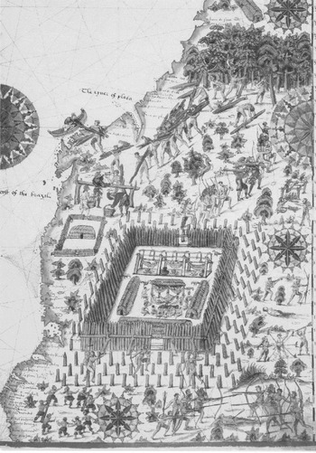
By far the most richly illustrated map in the atlas is the double-page sheet devoted to coastal Brazil (Figure 6). It details a range of Tupi activities: along the lower edge of the map are scenes of battles between Indian groups, ceremonial dancing, and a vignette of a man tied to a collection of stakes who is about to be struck with a club. The palisade in the centre of the map surrounds hammocks warmed from below by fires. Similar images appeared later in printed travel accounts, notably that of the German gunner Hans Staden.Footnote 76 Rotz's imagery is not exclusively peaceful. The centre of the map's right-hand edge reveals a seated figure cooking a human leg on a barbecue, while a dismembered body lies on the ground to the right of the palisade. Vignettes of cannibals cooking their victims had had a wide circulation in printed and manuscript images since at least 1505.Footnote 77
Jean Rotz, Rotz Atlas, 1542, fo. 28r, South America, MS Royal 20.b.ix. © British Library Board.

What is unusual about Rotz's map of Brazil in the context of representations of Brazil's inhabitants on European maps is its predominant imagery of peaceful exchange between Europeans – presumably Norman sailors – and Brazilians. We see the Tupinambá cutting trees with metal hatchets, and removing the bark with a tool resembling a metal cutlass.Footnote 78 The Tupinambá also trade the wood for items that resemble mirrors or hatchets, suggesting to the viewer that they had obtained metal tools from traders. They also transport the wood to the coast, and help the traders to load them onto a boat. This iconography of trade parallels accounts from two voyages, one Portuguese, the other French, that remained unpublished in the sixteenth century. In 1500, a Portuguese fleet under the command of Pedro Àlvares Cabral landed in a country he named Ilha da Vera Cruz. This turned out not to be an island at all, but the South American mainland; the region would later be called Brazil.Footnote 79 A letter detailing the discovery was sent by the fleet's appointed writer, the knight Pedro Vaz de Caminha, to King Manuel of Portugal.Footnote 80
Vaz writes approvingly of the innocence (inocência) of the indigenous people, who go about entirely naked in an Edenic fashion. Cabral's fleet traded with the Tupinambá on several occasions, giving them caps, hats, bells, and what Vaz describes as ‘other trifles of little value which they were carrying’.Footnote 81 In return, they received feather headdresses and a mantle, bows, and parrots.Footnote 82 That the Tupinambá would part with items valued by a civilized society in exchange for mere ‘trifles’ (cousinhas) suggested that they were considered to be as ignorant of economics as they were of modesty and shame. What might be called the unevenness in the balance of trade is remarked upon by numerous writers on America and must have been encouraging to the Norman armateurs. The loading of boats that Rotz illustrated parallels Vaz's account: the men ‘mingled so much with us that some of them helped us to load wood and put it in the boats, and they vied with us and derived much pleasure therefrom’.Footnote 83
The first French account of Brazil also described the promising trading potential of the Tupinambá. This was the deposition taken after the expedition led by Binot Paulmier de Gonneville, which had reached Brazil in 1504. We learn that ‘the Indians being a simple people, ask only to lead a happy life free of hard work’.Footnote 84 Although there is no mention of brazilwood, we learn that the Amerindians traded many items of immense value to the sailors far from home – such as food – in return for what the Europeans considered to be trifles, like mirrors: ‘the said goods amassed close to 100 quintals [5,000 kg], which would have fetched a good price in France’.Footnote 85
Amerigo Vespucci's letter to Piero Soderini, detailing his voyages to the north-east coast of South America at the turn of the sixteenth century, noted the promising trading opportunities.Footnote 86 Vespucci described the inhabitants’ characteristics, including nakedness, the lack of trappings of European society, and naivety in trading. As a merchant, Vespucci paid particular attention to potential commodities. He observed what the Amerindians themselves valued, commodities that were deemed useful in Europe, and moments of gift-exchange. The Tupinambá ‘are liberal in giving, and rarely deny you anything’.Footnote 87 Vespucci writes how ‘we bought from them around 150 pearls, for a single bell, along with a bit of gold, which we added as a gift to them’.Footnote 88 A similar encounter took place later: ‘We acquired 119 marks of pearls for no more than forty ducats, because what we gave them was nothing other than bells, mirrors and glass beads and brass leaves; one of them traded all the pearls he had for one bell.’Footnote 89
A number of influential woodcut images appeared in editions and translations of Vespucci material. An anonymous broadsheet printed by Johann Froschauer 1505–6, with text extracted from Vespucci, shows limbs hanging from beams; the 1509 Strasbourg edition of Vespucci's Soderini letter to Piero Soderini includes an illustration of a cannibal butcher's block, complete with a hatchet-waving anthropophage dismembering a victim.Footnote 90 These highlighted the anthropophagous predilections of the peoples of the north-east coast of South America. No images showed Brazilians as woodcutters. The Vespucci imagery had only a limited impact on Norman map iconography; indeed, as we shall see later, the mapmaker Pierre Desceliers borrowed from Vespucci's writing while consciously omitting a passage on cannibalism.
Rotz's image of Brazil, while reflecting the gamut of activities that had also been described in published and unpublished sources, placed relatively little emphasis on cannibalism. The bright crimson tunics of the French traders and the reddish logs carried by the Tupinambá draw the viewer's attention away from the unsavoury aspects of Tupi life. To the right of the wood-transportation scene is a group of Tupinambá who appear to be marching alongside French traders bearing muskets. The image, far from suggesting that Rotz's comrades were in danger of being eaten by these cannibals, might have indicated that the Tupinambá were on such good terms with them that they practised joint military manouevres. Indeed, alliances between the Tupinambá tribes and the Normans greatly facilitated Normans incursions into areas that were claimed by the Portuguese.
The unusual richness of the illustrations may be explained by Rotz's aspirations to royal patronage. Rotz recounts how he had initially set out to present his atlas to François I of France, but decided towards the end of the work to dedicate it instead to Henry VIII of England.Footnote 91 The lavish illustrations of Brazil – the most detailed in the entire atlas – reveal Rotz attempting to convince a royal patron that he was particularly knowledgeable about the New World.Footnote 92 The atlas, then, was an intellectual gift that held the possibility of further reward: first-hand experience from a Norman sailor. Rotz hoped that his expertise would prompt Henry to offer him a post, and to sponsor his own voyages. Around 1531, a Brazilian king had been brought to Henry's court, and the English had begun to trade in Brazil.Footnote 93 Unfortunately for Rotz, while his overtures led to his appointment as royal hydrographer in 1542, Henry's interest in voyages to America proved to be transient. Rotz returned to France in 1547.Footnote 94
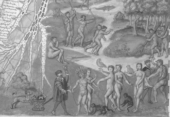
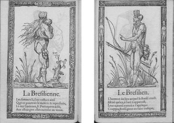
An even greater concentration on trade appears on the 1547 work known as the Vallard Atlas. It is so named because of an annotation on the first page: ‘Nicolas Vallard de Dieppe / 1547’.Footnote 95 Vallard is believed to have been its author or an early owner.Footnote 96 Two of the fifteen maps in this atlas cover north-eastern South America and show Europeans trading with the Brazilians for dyewood.Footnote 97 A double-page map shows the eastern seaboard from Brazil to the Straits of Magellan (Figure 7). In addition to generically peaceful scenes of Amerindians with bows and arrows, and also with logs (presumably dyewood), there is a detailed scene of European–Tupinambá trade in the foreground, in the region of Brazil. At the centre, a European provides some women with a mirror in exchange for a parrot, and perhaps also a monkey.Footnote 98 An image of the Brazilian as a woodcutter, and a reference to women trading with visitors, later appeared in François Deserps's costume book of 1562. Under the portrait of a Brazilian man and woman is the verse, ‘the women there are dressed just as / this picture shows and represents. / There, monkeys, and parrots also, / they put up for sale to strangers’ (Figure 8).Footnote 99 Although this is a costume book, the Brazilian man is characterized by trade rather than dress – ‘he applies himself to the natural work of / cutting down Brazil trees in order to trade them’.Footnote 100 The genre of the costume book concentrated on civil rather than savage images of (mostly European) peoples. This does not, however, mean that Deserps must have manufactured peaceful rather than cannibalistic images of Brazil's inhabitants in order to fit them into his costume book. Elsewhere in the book, he included more fantastic, implicitly savage beings, notably the standing ape of Peru and the mythical Cyclopes whose ‘lineage continues yet’.Footnote 101 Although we cannot be sure that Deserps had not seen the Vallard Atlas, it is much more likely that the Tupinambá illustrations in these two works were independent, based on Norman trading experiences in Brazil.Footnote 102 The hairy appearance of Deserps's man and woman of Brazil suggests another strand of influence. Hairiness was often associated with the wild men of folklore, people who lived in forests or caves without the trappings of civilized life.Footnote 103
Vallard Atlas, c. 1547, fo. 12, HM 29. Image reproduced by permission of the Huntington Library, San Marino, California.

François Deserps, Receuil de la diuersité des habits … (Paris, 1562), unpaginated, Typ 515.64.734, Houghton Library, Harvard University.

On the Vallard Atlas, the scene of monkey- and parrot-trading is flanked by images showing the goods that were exchanged for them. To the left of the vignette is a basket of what appear to be hatchets. On the right, another European offers a curved knife or hatchet to a Brazilian. The map illuminator seems to have heard about the trading of glass and ironmongery on a French voyage. The Gonneville expedition report had noted that the sailors did indeed trade ‘combs, knives, hatchets, mirrors … and such trinkets’.Footnote 104 While we cannot say that these motifs came from a particular text or traveller, the evidence is indicative of the close attention that was on occasion paid to travellers’ testimony.
Although there are no surviving descriptions of the Tupinambá–French brazilwood trade that pre-date any of the maps examined here, later accounts offer corroborating evidence for many elements of the map illuminations. Brazilwood is discussed in two works by the Franciscan friar and traveller André Thevet.Footnote 105 In his Singularitez (1557) we learn that
when the Christians … go there to obtain brazilwood, the savages of the country cut it down and chop it up, and they carry it three or four leagues in a single journey up to the ships; I leave you to imagine the effort needed, and this for the desire to acquire some meagre clothes of poor linen or a shirt.Footnote 106
The amount of French effort saved by the Tupinambá added to the profitability of exchanging prized brazilwood for items that were inexpensive in Europe. In his Cosmographie universelle (1575), Thevet illustrated the Brazilians chopping trees and noted that the quality of the brazilwood was so good that one could obtain two tinctures out of it.Footnote 107 Thevet's description of the willingness of the Brazilians to carry logs for Europeans parallels the vignettes that had appeared on many earlier Norman works, including the Rotz and Vallard atlases.Footnote 108
Further corroboration appears in the Calvinist Jean de Léry's Histoire d'un voyage fait en la terre du Brésil, first printed in 1578. He apparently penned his first draft in brazilwood ink.Footnote 109 Léry, like Thevet before him, stressed the importance of indigenous labour in a country that lacked beasts of burden: ‘if the foreigners … were not helped by the savages, they could not load even a medium-sized ship in a year’.Footnote 110 In return for simple clothing and tools,
the savages not only cut, saw, split, quarter and round off the brazilwood, with the hatchets, wedges and iron tools given to them by the French and by others … but also carry it on their bare shoulders, often from a league or two away, over mountains and difficult places, clear down to the seashore … where the sailors receive it.Footnote 111
This exchange of ironmongery for Brazilian goods corroborates Norman map vignettes showing Tupinambá willingness to prepare and carry logs. Tupinambá generosity did not simply spare French labour; it also reduced their need for fixed bases in Brazil. The uneasy and often hostile relations between French traders and the Portuguese crown meant that the French did not establish settlements and factories in Brazil for processing or collecting logs. Their first attempt at running a factory was put paid to by the Portuguese.Footnote 112 In case the reader is left with the sense that the Tupinambá are being exploited, Léry hastens to explain that before the Tupinambá were presented with European tools, they had not had the technology to fell a tree other than by setting fire to the base.
A visual parallel of the cartographic iconography appears on two oak panels that comprise the only surviving portion of the façade of the Hôtel du Brésil. This building stood at 17 rue Malpalu in Rouen and accommodated visiting Brazilians – such as those who participated in the royal entry celebrations of 1550.Footnote 113 The panels, of a total length of nearly four metres, depict Brazilians aiding the dyewood trade. On the longer piece, the right-hand portion shows a partly cut forest in which they fell more trees. Another figure uses an implement to remove the bark from a tree. Of two men carrying tree-trunks, one leads a boy carrying a bird (a parrot, perhaps), with a monkey at his feet. Also noteworthy are the parrots balancing on several tree-trunks. On the second panel, logs are collected and presented to two sailors loading a boat; a two-masted ship is anchored nearby.Footnote 114 None of these compositions is identical to a map image, but the content is certainly similar to the range of imagery found on the Rotz and Vallard atlases.
There were, then, general correspondences between images in Norman cartography, visual culture, and published and unpublished texts about Brazil, but no clinching evidence of direct links to texts. It seems legitimate to infer that mapmakers were relying, at least partly, on oral and informal methods to gather information. In one case, however, the 1550 planisphere by Pierre Desceliers, we can be sure about a Norman mapmaker's direct reliance on – and selective borrowing from – a written source. Desceliers was a priest, cartographer, and teacher of mathematics and navigation, whose students included armateurs, sea captains, and apprentice-pilots, including Jean Ango. Many of them entered the employ of the elder Ango (Jean's father), with whom Desceliers collaborated on occasion.Footnote 115 The map contains a lengthy caption in South America (Figure 9):
The men and women are of medium build. The men are naked and red-skinned, with large faces … Their weapons are bows, arrows, and clubs which they know how to use well … They recognize no leaders, being men without order living freely … They sleep in cotton beds hung from trees. Their language differs every hundred leagues. They have clean bodies because they wash frequently, living without law or marriage. Their houses are large – capable of accommodating 600 people – and covered with palm leaves. Every seven or eight years they move because and in fear of illness … Their riches are birds’ feathers and green and white stones.Footnote 116
The map as a whole is similar in composition to world maps prepared by the German cartographer and humanist Lorenz Fries, based on Waldseemüller's 1516 world map. Nevertheless, Desceliers's inscription has no parallel in Fries's maps, which depicted cannibals in Brazil after Waldseemüller's example (Figure 1), and described them in an accompanying booklet.Footnote 117 Instead, the above quotation closely matches information published in Vespucci's letter to Soderini. The letter is worth quoting at length and comparing to Desceliers's inscription:
They are of medium stature and very well proportioned. The colour of their skin inclines to red, like the skin of a lion, and I believe that if they went around covered with clothes, they would be white like us … Their arms are bows and arrows, which they knew how to make very accurately … They have no war-leaders and no commanders, and they march (since everyone is a lord of himself) preserving no order … They sleep in certain large nets made of cotton, and suspended in the air … They are very clean and neat in their bodies, because they very frequently wash themselves … They observe neither law nor legal contract in their marriages. Their homes are constructed in the shape of bells, but strongly built of very large trees and covered with palm leaves, secure from tempests and winds. In some places they were so large that we found 600 people in a single house … They move their homes or dwellings every seven or eight years, and when questioned as to the reason for this, they gave a reply concerning nature, saying they did this at times of the intense heat of the sun on account of which, because of the length of time they lived in the houses, the air became infected and corrupt, which caused various illnesses in their bodies … Their wealth consists of the feathers of birds of many colours, or in the fashion of beads which we call ‘paternosters’ in the common tongue; they make plates or counters from the fins of fishes, or from white or green stones, and for ornament they hang these from their cheeks, lips and ears; and they also regard other similar worthless and trifling things for riches, which we considered entirely paltry.Footnote 118
Desceliers has summarized Vespucci's several-page description, selecting particular traits and habits: skin colour, weapons, lack of leaders, hammocks, houses, wealth, and ornaments. He presents the information in the same order as Vespucci, which clearly signals his dependence on the passage. He has changed its tone – we move from a first-person narrative to an impersonal report. For instance, in the description of the evacuation and transplantation of villages in Vespucci's letter it is clear that the explorers themselves obtained the information. Desceliers summed this up as: ‘Every seven or eight years they move because and in fear of illness.’ His account is detached, almost omniscient, with no indication of a mediator, or any sense that an interpretation of the Amerindians and their customs is what is presented. Desceliers refers only to some of the riches mentioned by Vespucci, trimming the passage for clarity. This very specific use of a printed text contrasts with the more fluid relationship between most images on Norman maps and travel accounts.
Desceliers planisphere, 1550, Add. MS 24095. © British Library Board.

Particularly interesting is the omission of any mention on Desceliers's map of Brazilian cannibalism. By contrast, Vespucci's text continues by providing lurid details of the Amerindians’ consumption of human flesh. Desceliers and other Norman mapmakers may have made little of cannibalism since the threat was smaller for the French than for other Europeans. Hans Staden's Warhaftige Historia (1557) described how he had been held captive for nine months by the Tupinambá. On several occasions, he narrowly escaped being killed and eaten by assuring the Tupinambá that he was French, as the two peoples were on good terms. Other Europeans had evidently tried this before; Staden says of a Tupinambá leader, ‘he had already helped to catch and eat five Portuguese who had all said that they were French but had lied’.Footnote 119 In the early seventeenth century, the English traveller Anthony Knivet recounted a similar story.Footnote 120
While Norman mapmakers were clearly choosing to emphasize trade and peaceful inhabitants over cannibalism, this does not constitute a total fictionalization of the situation in Brazil. As Staden's and Knivet's accounts show, French relations with the Tupinambá do seem to have been good. A manuscript navigation manual provides further evidence of the cordial relationship between the Tupinambá and Norman navigators. Prepared by the Rouennais Jean Cordier, it includes a Tupinambá–French glossary. Eighty-five terms and phrases are translated. The majority deal with everyday life: greetings, members of the family, words denoting hunger or thirst, objects and clothing, distance, and weather.Footnote 121 Norman interpreters were important mediators between the French and the Tupinambá. Sometimes these intermediaries over-stepped their instructions and went native, even participating in cannibal feasts. They became Brazilians, even taking local wives. One of them, Goset, mentioned by Lery, was made a chief, and gave his name to the tribe that had adopted him.Footnote 122 While the Normans may not have been in danger of being eaten, they were well aware of cannibal practices. However, since they too were implicated, they would have been keen to underplay them.
III
How might viewers of these maps have interpreted the customs and appearance of these peoples? The scanty clothing of the Tupi tribes might have brought to mind the wild man (and woman) of medieval folklore. The wild man in European thought has its roots in several traditions, including Greek and Roman mythology (which contributed Hercules and Cyclopes)Footnote 123 and the Christian traditions of hermit saints and of giants.Footnote 124 Wild men were frequently characterized by extreme hairiness covering their bodies (generally apart from their faces, hands, knees, and elbows).Footnote 125 They might be naked, wear skins of animals, or merely dress in skimpy foliage around their waists. They were ‘monstrous’ in their behaviour, but could be civilized through exposure to other lifestyles. Wild men bore tree-trunks or clubs as weapons, and lived in the woods, away from civil people.Footnote 126 They were often depicted with shields, clubs, or staffs, and this imagery sometimes decorated heraldic devices.Footnote 127 Other common characteristics included great strength, hairy bodies, and living in forests, alone or with mate and children.Footnote 128 In the late medieval period, traditional folkloric views of the wild man seem to have shifted from negative to positive.Footnote 129
At the turn of the sixteenth century, the earliest printed imagery of the Amerindians conflated these peoples with the ancient, wild ancestors of the German peoples. The recently re-discovered text of Tacitus's Germania, first printed in the 1470s, contrasted the tribes of the Germanii who inhabited fields and forests and had neither laws nor written language with the urban and civilized Romans. German humanists like Conrad Celtis turned their lack of the trappings of civilization into a virtue. They identified their sylvan ancestors with the mythological wild man, and championed them as simple and unspoiled. Celtis used this interpretation to argue against Italian and papal influence on German affairs.Footnote 130 The earliest German woodcuts of Amerindians ‘began life’, as one art historian put it, ‘in the boots of the invented and conventional persona of the wild man’.Footnote 131 Illustrations to early editions of Vespucci's letters depicted these peoples with little or no clothing and long, curly hair and beards when, in fact, these peoples had straight hair and no beards.Footnote 132 While the peoples in Brazil on Norman maps had neither curly hair, nor body-hair (which they plucked out), nor animal-skin costumes, their near-nudity, open-air lifestyle, and frequent association with tree-trunks offered parallels with the folkloric wild man.
Contemporary conceptions of peoples who possessed neither the trappings nor the vices of civilization as similar to wild men might well have prompted viewers to perceive these peoples in a positive light. An especially pertinent interpretative context is the 1550 Rouen entry pageant for Henri II. This placed the Tupinambá in a broader scheme that characterized them as heroic warriors. As one chronicler of the pageant put it, in skill and bravery, they surpassed even the Trojans, who were thought to be the ancestors of the French.Footnote 133 The Brazilian scene was immediately preceded by one of Hercules – associated with skill, strength, and bravery – battling a Hydra. These values were core to the ancient French nobility; Henri II was known for his own martial prowess, deeply suited to the French ideal of the warrior king. At the same time, the image of Hercules as a wild barbarian was being transformed in humanist literature into a personification of humanist values. Indeed, as Michael Wintroub has argued persuasively, the purpose of the entry as a whole seems to have been to encourage Henri to marry his martial skills with those of humanist learning.Footnote 134 The writings of later French travellers to Brazil offer evidence of this conceptual connection between Hercules and Brazilians. Marc Lescarbot, the early seventeenth-century explorer, author, and lawyer, compared Brazilians to images of Hercules; André Thevet added an engraving of the Tupinambá leader Quoniambec to his Portraits et vies des hommes illustres (1584), and described him as a New World Hercules.Footnote 135
Brazilian representations on Norman maps are a complex blend of reality and selective advertising. They show that even maps with political agendas were not necessarily devoid of accurate information. The Norman experience of Brazil was indeed different from that of other people and states. Part of the reason for this was the fact that the French kings frequently changed their minds over whether or not to outlaw their subjects’ activities in Brazil, a situtation that prompted Jean Rotz to sell his expertise to Henry VIII of England instead. While Portuguese merchants were also engaged in the brazilwood trade, their crown did not need to be convinced of the importance of supporting their activities. Their maps contain cannibal, woodcutter, and more general ethnographic scenes, but the cannibal motifs are more prevalent.
These maps prompt us to rethink the approach by which the non-cartographic contents of maps are automatically reduced to either ‘mere decoration’ or propaganda in both traditional interpretations of cartography and the revisionist approach of J. B. Harley and later scholars.Footnote 136 It is clear that mapmakers did not necessarily prefer sensational or violent images to peaceful ones for the sake of selling more maps. We need to widen the view of the needs that might be served by the imagery on maps. It is also clear that ethnographic ‘spin’ was not necessarily negative, and that sympathetic relations between Europeans and others in the field, as it were, could be interpreted back in Europe in a similar light. Norman mapmakers were well aware of the cannibal practices of the Tupi people, even representing it on some of their maps. Nevertheless, they did not present cannibalism as the most important aspect of Tupi life, or of European encounters with the Tupi.