
Introduction
Cultural communication and transmission helped shape Old World civilisations, and crops have been an important category of such exchange since the third millennium BC (e.g. Dong et al. Reference Dong, Yang, Han, Wang and Chen2017). The Inner Asian Mountain Corridor of Central Asia (sensu Frachetti Reference Frachetti2008) has produced the earliest secure evidence of millets of Chinese origin outside of China, as well as of wheat and barley before their appearance in central China (Spengler et al. Reference Spengler2014; Stevens et al. Reference Stevens, Murphy, Roberts, Lucas, Silva and Fuller2016; Zhou et al. Reference Zhou2020). Early connections across central Asia have been modelled in terms of down-the-line diffusion of crops through a network of seasonally transhumant pastoralists (Frachetti et al. Reference Frachetti, Smith, Traub and Williams2017), but the role of expansion by migrating cereal farmers, as they and their crops adapted to higher-elevation environments, also needs exploration (Motuzaite-Matuzeviciute et al. Reference Motuzaite-Matuzeviciute, Hermes, Mir-Makhamad and Tabaldiev2020). More generally, such processes of globalisation have played a significant role in the evolution and versatility of crops that lies between initial domestication and modern agronomic diversity; an area that has been under-theorised (Fuller & Lucas Reference Fuller, Lucas, Petraglia, Boivin and Crassard2017; Liu & Jones Reference Liu and Jones2024).
In the context of Chinese archaeology, research has explored how free-threshing wheat was added to millet-centric agriculture from the late third millennium BC (Liu et al. Reference Liu2017; Deng et al. Reference Deng, Fuller, Chum, Cao, Jiang, Wang and Lu2020). In contrast, barley is little known from central China but was important for the expansion of agriculture to higher elevations in Qinghai/Tibet from c. 1600 BC (e.g. Chen et al. Reference Chen2015; d'Alpoim Guedes et al. Reference d'Alpoim Guedes, Hongliang Lu, Hein and Schmidt2015; Liu et al. Reference Liu2017; Li et al. Reference Li2019). Unlike other cereals, barley can tolerate cultivation at extremes of altitude, up to approximately 4200m above sea level (m asl) (Council of Scientific and Industrial Research 1959).
Barley (Hordeum vulgare sensu lato) originated from south-western Asia, undergoing domestication between c. 11 000 and 9500 BP, initially as a two-row hulled form (Zohary et al. Reference Zohary, Hopf and Weiss2012; Fuller & Weisskopf Reference Fuller, Weisskopf and Smith2014). Barley then diversified into six-row and naked forms, and these varied forms dispersed outwards from the Fertile Crescent to Europe, Africa and Asia. To the east, barley spread initially through Iran and southern Central Asia (Turkmenistan), including both hulled and naked six-row forms (Charles & Bogaard Reference Charles, Bogaard and Harris2010), reaching Djeitun in southern Turkmenistan c. 8000 BP. It is only around 3000 years later that both kinds of barley and wheats are found in the Inner Asian Mountain Corridor of northern Central Asia, represented by Tongtian Cave in the Altai, approximately 1800m asl, c. 5000 BP (Zhou et al. Reference Zhou2020), and Kochkor Valley sites of Kyrgyzstan, approximately 2000m asl, c. 4500 BP (Motuzaite-Matuzeviciute et al. Reference Motuzaite-Matuzeviciute, Hermes, Mir-Makhamad and Tabaldiev2020). After a pause in the Indus region, barley spread to other parts of India east of the Indus from around 4500 BP (Fuller Reference Fuller2006). This indicates a three-stage process of the dispersal of barley and wheat from their region of origin into South and Central Asia.
In China, early discoveries of barley are disparate from the evidence for wheat, being generally later in central China. Following the earliest barley and wheat from the Tongtian Cave site, dated back to 5200 BP (Zhou et al. Reference Zhou2020), the next earliest barley remains come from a group of sites in north-eastern Qinghai (Chen et al. Reference Chen2015), dated between 4000 and 3600 BP. Within the Tibetan Plateau itself finds of barley post-date 3400 BP (see online supplementary material (OSM), Tables S1 & S2).
We report here on barley remains, dating back to 3500 BP, found in the Gepa serul cemetery in the Ngari region of the western Tibetan Plateau (Figure 1; Table S3 provides Tibetan and Chinese versions of placenames). Now among the earliest finds of barley in Tibet, these new data prompt us to revisit the archaeological evidence for the distribution of various forms of barley prior to their appearance in Tibet.
The location and overview of Gepa serul in relation to south-western Tibet and adjacent India, selected places and rivers indicated (figure by Dorian Q. Fuller).

Ngari environment and the Gepa serul setting
Ngari is the highest and coldest region on the Tibetan Plateau, with an average altitude of 4800–5000m asl (Tashi Tsering et al. Reference Tashi, Shargan, Xi, Yu, Tenzin and Liu2022). The climate is cold, dry and windy, with annual precipitation less than 50–100mm and an annual mean relative humidity of 30–40%. Soil is thin and sandy, typical of alpine desert. Although the sparse grassland is of low quality, animal husbandry is widely practiced, including the keeping of sheep and goats for meat, and of yaks that also provide milk.
In Tibet, today, the primary cereal crops are barley, wheat and pea, while secondary crops include broad bean, potato, buckwheat, maize and, at lower elevations, rice and finger millet (Wang Reference Wang2012). Naked six-row barley, commonly named qingke, is dominant, occupying 81.5 per cent of the sown area (Team for Comprehensive Scientific Survey in the Tibetan Plateau 1984). Ngari prefecture has the lowest agricultural productivity in Tibet.
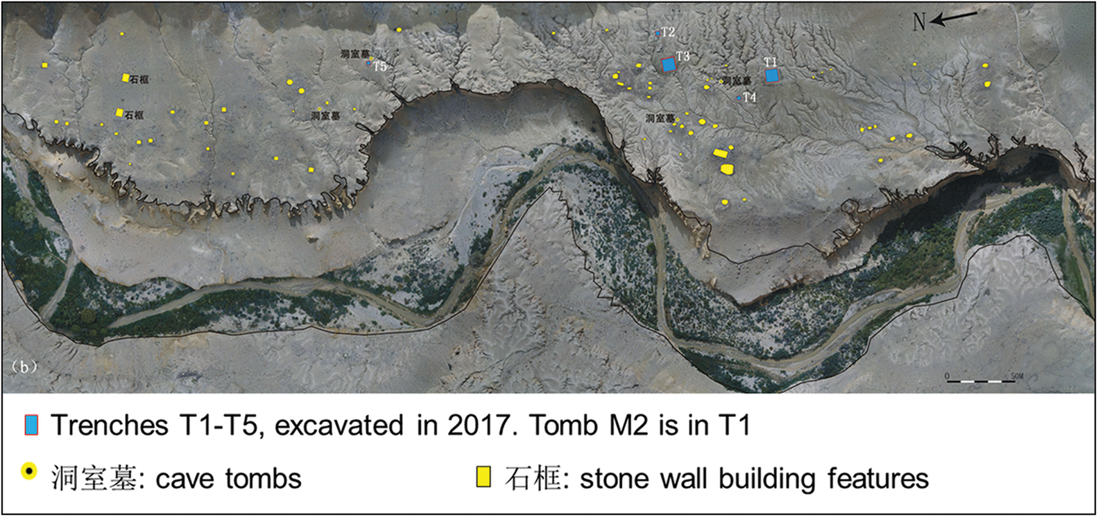
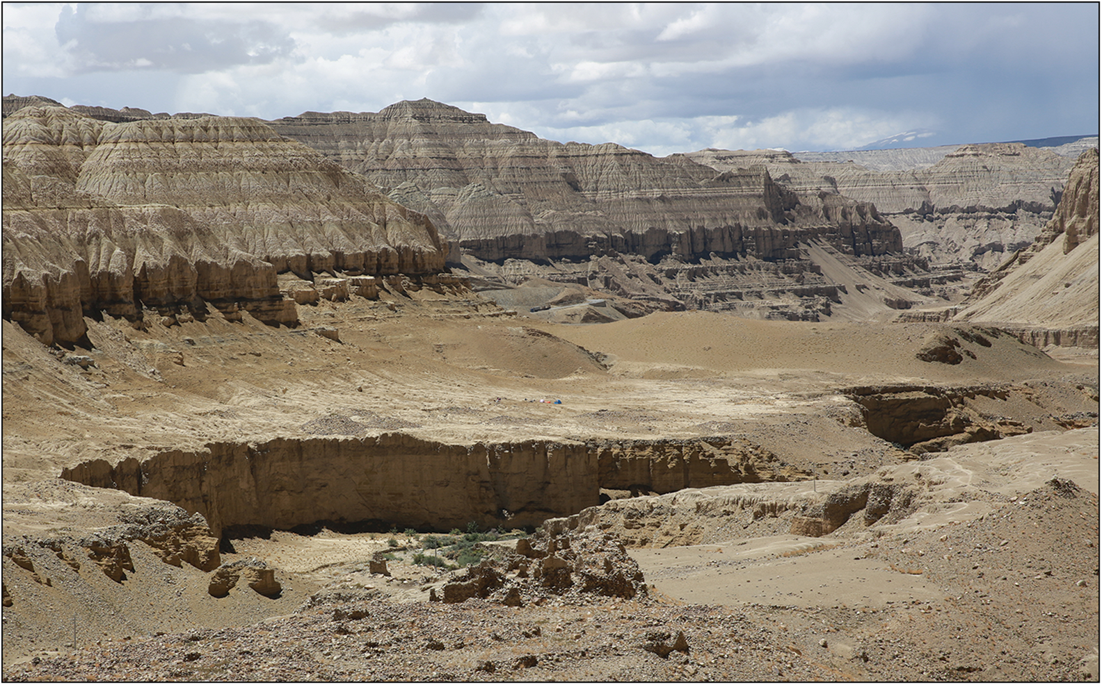
Gepa serul (79°48′45.5″E, 31°33′43.0″N, 3780m asl) is a cemetery on the east terrace of Sang dar lung shur brook (Figures 2 & 3), a northern branch of the Glang-chen Gtsang-po river, which becomes known as the Sutlej in India. The cemetery is near the northern Himalayan border of India. This region is the place of origin of three great rivers of South Asia—the Brahmaputra, the Ganges and the Indus—and is famous for the sacred Mount Kailash and Lake Manasarovar (Figure 1). In the past, the Zhang zhung and Gu ge kingdoms were centred in this territory (Huo Reference Huo1997; Zhang Reference Zhang2009).
Overview of the Gepa serul site east of the Sutlej River. Scale is 50m (figure by Shargan Wangdue).

Setting of the Gepa serul excavations, viewed from the north-west looking south-east across Sangda brook. The excavation camp is in the middle of the photo (photograph by Liya Tang).

The Gepa serul cemetery was first discovered and investigated in 1999 (Li Reference Li2001). In 2017, the archaeological union of the Institute of Cultural Relics Protection of Tibet Autonomous Region, Shaanxi Academy of Archaeology and the School of Cultural Heritage of Northwest University in Xi'an renewed excavations at Gepa serul, focusing on eight tombs belonging to phase I (c. 3600–3000 BP).
Materials and methods
During the 2017 excavations, 34 soil samples were collected from tomb M2, including 12 from inside ceramics (Figure 4). A total volume of approximately 11 litres of soil samples was dry sieved at Northwest University (Xi'an, China) using a 0.4mm mesh to recover plant remains. Identifiable carbonised grains were found in the contents of jar 8 and one grain was directly radiocarbon dated.
Plan and sections of tomb M2. Ceramic vessels containing charred plant remains are shown in the niche at the northern end of the grave (figure by Shargan Wangdue, Tashi Tsering & Chun Yu).

Results
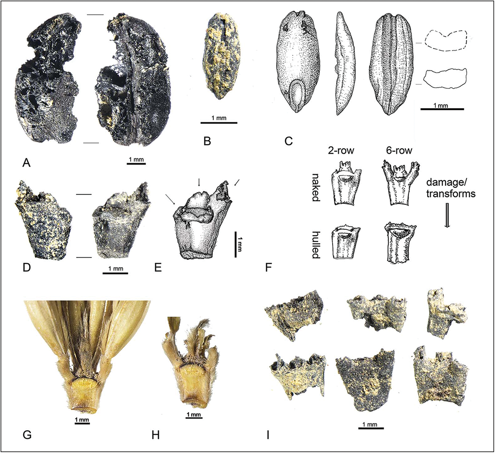
Two carbonised cereal grains, 24 carbonised rachises and one smaller carbonised grass grain were found during the dry sieving (Figure 5). The carbonised grains and rachises are identified morphologically as domesticated naked six-row barley (Hordeum vulgare L. subsp. vulgare var. coeleste L., syn. Hordeum hexastichum L. var. coeleste) (on taxonomy see Zohary et al. Reference Zohary, Hopf and Weiss2012). Spikelet trifurcation can be seen on the rachis nodes, which is typical of six-row barley (Figure 5D–I). Six-row barley has substantial lateral floret bases that flare outwards at the top of each rachis segment. Naked forms have persistent raised floret bases extending above the top of the rachis segment, although these may be damaged and removed through charring or post-depositional processes, which can make naked forms emulate hulled forms (but not vice versa). The barley grain is large, 6.98mm long and 4.17mm wide; it lacks the angular cross-section of hulled barley (Figure 5A).
Archaeobotanical remains from Gepa serul M2, with relevant comparative material. A) dorsal and ventral view of barley grain; B) ventral view of weedy brome grass grain (Bromus cf. ramosus); C) drawing of Bromus cf. ramosus grain; D) two views of a barley rachis segment; E) drawing of adaxial view of barley rachis with arrows indicating floret bases indicative of six-row, naked barley; F) sketches comparing the four potential types of barley rachis; G) photograph of Tibetan qingke six-row, naked barley rachis and spikelet base; H) photograph of Tibetan qingke six-row naked barley with florets removed; I) additional examples of barley rachises from Gepa serul M2. All scale bars are 1mm (figure by Dorian Q. Fuller & Liya Tang).

The single grain of grass is identified as belonging to the weedy genus Bromus. Based on its form, size and geography it is referred to Bromus cf. ramosus, although it is not possible to determine this confidently to species level based on morphology alone (Figure 5B & C).
Direct radiocarbon dating of one grain provides a calibrated range of 1505–1397 cal BC (95.4%) (based on Reimer et al. 2020) (Beta489360 3170±30 BP, δ13C -22.2).
Discussion
Despite the small overall size of the sample, the barley from Gepa serul appears to be the naked six-row variety. Evidence for earlier or contemporaneous finds of naked and hulled barley have been plotted (Figure 6, Tables S1 & S2), based on an updated version of the Asian Crops Archaeobotanical Database (updated after Stevens et al. Reference Stevens, Murphy, Roberts, Lucas, Silva and Fuller2016). While two-row forms may be included in these distributions, we expect six-row barley to be normally present by the periods under consideration, and to tend to dominate barley cultivation—owing to its three-fold seed production—unless there is strong cultural and/or environmental selection for the maintenance of the two-row forms (Palmer et al. Reference Palmer, Moore, Clapham, Rose and Allaby2009). This is also implied by the genetic data, as naked forms with soft hulls appear to have evolved just once by the nud mutation (Taketa et al. Reference Taketa, Kikuchi, Awayama, Yamamoto, Ichii and Kawasaki2004; Lister & Jones Reference Lister and Jones2013), whereas six-row forms evolved multiple times (Komatsuda et al. Reference Komatsuda2007; Palmer et al. Reference Palmer, Moore, Clapham, Rose and Allaby2009).
Geographical distribution of archaeological naked and hulled barley across Asia. Above, map of naked barley remains (including or predominantly of six-row); shaded region in China includes many reports of suggested naked barley where morphological details have not been rigorously reported. Below, map of hulled barley reports across Asia. Site data in OSM S1 and S2 (figure by Liya Tang & Dorian Q. Fuller).

Both six-row and naked barleys are present in Western Asia before the end of the Pre-Pottery Neolithic and as early as 10 000–9500 BP (Zohary et al. Reference Zohary, Hopf and Weiss2012). In central Anatolia, Çatalhöyük (from 9100 BP) demonstrates the full range of barley varieties, but two-row naked barley is predominant (Bogaard et al. Reference Bogaard, Filipović, Fairbairn, Green, Stroud, Fuller and Charles2017). This barley diversity appears to be typical not just of Neolithic Anatolia but also of the initial dispersal of cereal crops into Europe, as represented by the archaeobotanical assemblage from Knossos (c. 8500 BP) (Kotzamani & Livarda Reference Kotzamani and Livarda2018). Both hulled and naked barleys reached Central Asia in the Neolithic, and indeed six-row naked forms are reported to be the dominant barley at Djeitun in southern Turkmenistan (c. 8000 BP) (Charles & Bogaard Reference Charles, Bogaard and Harris2010) and at Mehrgarh in Pakistan (c. 7000 BP) (Fuller Reference Fuller2006). The spread of barley further eastwards slowed, with most finds from the Indus region and beyond dating after 4500 BP (Fuller Reference Fuller2006; Liu et al. Reference Liu2017). One reason for this may have been the necessary adaptation to warmer winters and earlier harvests. Although there was a diversity of barley for early farmers to choose from in Central and Southern Asia, hulled barleys were less favoured, with naked barley dominant from southern Turkmenistan to the highland steppe of eastern Kazakhstan and in the mountain valleys of Kyrgyzstan (Spengler et al. Reference Spengler2014; Motuzaite-Matuzeviciute et al. Reference Motuzaite-Matuzeviciute, Abdykanova, Kume, Nishiaki and Tabaldiev2018, Reference Motuzaite-Matuzeviciute, Hermes, Mir-Makhamad and Tabaldiev2020). In South Asia, both barleys, including hulled barley, were found from the western edge of the Himalayas (Pokharia et al. Reference Pokharia, Mani, Spate, Betts and Srivastava2018; Betts et al. Reference Betts, Yatoo, Spate, Fraser, Kaloo, Rashid, Pokharia and Zhang2019; Yatoo et al. Reference Yatoo, Spate, Betts, Pokharia and Shah2020; Spate et al. Reference Spate, Yatoo and Betts2021).
Six-row naked barleys are also the more prevalent varieties in China. This includes the early finds at sites in Qinghai, 4000–3500 BP (Chen et al. Reference Chen2015) and sites in south-eastern Tibet dating from the period 3500–3000 BP (Table S1). Finds of hulled barley in China are less common but these varieties are notably present among finds from Bronze Age Yunnan—for example at Bronze Age Haimenkou (c. 3400 BP) (Xue et al. Reference Xue, Dal Martello, Qin, Stevens, Min and Fuller2022).
Contrasts between archaeobotanical assemblages in central China and the Tibetan plateau suggest that the diffusions of wheat and barley cultivation into these areas were separate. Some barley likely entered the Tibetan plateau from the north-east, via Qinghai province, while wheat spread at lower elevations eastwards to central China (Chen et al. Reference Chen2015; d'Alpoim Guedes et al. Reference d'Alpoim Guedes, Hongliang Lu, Hein and Schmidt2015). Somewhat later, and more in central Tibet, the site of vPhrang mgo shows a mixed agriculture of millet, wheat and barley, c. 3300 BP (Fu et al. Reference Fu, Ruan, Dai and Liu2000; Lu Reference Lu2016). In addition, the latest barley dating result from Chu kong near Lhasa is 3369–3211 BP (Gao et al. Reference Gao, Yang, Ma, Tong and Yang2020). However, most of the reported evidence for barley in Tibet comes from sites 1100–1600km east of Gepa serul.
The northward dispersal of wheat and barley to the Tian Shan Mountain region and then eastwards into the northern latitudes of China would have required the acquisition of spring seasonality, to avoid frost damage in the harsh winters (d'Alpoim Guedes et al. Reference d'Alpoim Guedes, Manning and Bocinsky2016; Liu et al. Reference Liu2017). It should not be assumed that both barley and wheat evolved the necessary genetic adaptations in tandem; indeed the hexaploid status of bread wheat may have provided an advantage over the diploid barley, allowing for adaptational flexibility in dosage effects of variant alleles across its three genomes (Dubcovsky & Dvorak Reference Dubcovsky and Dvorak2007).
Barley originates from the low altitude region of South-west Asia, where winters are mild and rainy, and is a kind of long-day plant, which grows through winter and flowers in later spring as days lengthen. This trait is underpinned by genes affecting photoperiod response, as well as vernalisation genes that are activated by cold winter days (Fu et al. Reference Fu2005; Cockram et al. Reference Cockram, Hones and O'Sullivan2011; Liu et al. Reference Liu2017). Spring-adapted genotypes that flower after days shorten over summer are rare in wild barley but occur in populations from the mountains of northern Iran, suggesting a genetic contribution from these populations. Whether this means that all spring varieties derive from this region is not currently clear. Warm winters in parts of the lower Indus Valley, for example, would also favour autumn or spring sown varieties, without the need for vernalisation.
Ngari in western Tibet may have received crops directly from the west rather than via north-west China. Naked barley from the Ting dom site, not far from the Gepa serul cemetery, dating to 2400–1900 BP, is suggested to result from diffusion from the Indus region (Lu Reference Lu2014). Gepa serul substantially pushes back the arrival of barley in western Tibet, to a date that is earlier than its appearance in central Tibet and nearly as early as evidence from Qinghai Province.
Here, we consider two westerly routes for dispersal of barley to south-west Tibet. One hypothesis is an upward spread from the Indus Valley using Himalayan river valleys, such as the Sutlej. The other is diffusion along the northern margin of the Iranian Plateau, through the Pamir mountains—especially the Wakhan corridor—then via the Kashgar region of southern Xinjiang Province, into Ngari. A riverine dispersal might be hypothesised to have involved winter-grown barley, perhaps evolving into spring-grown varieties as the crop moved up the Indus and its tributaries into mountainous regions. In contrast, a mountain-corridor route would require an earlier evolution of spring barley, that would have stayed at higher elevations or spread to higher latitudes.
For the riverine hypothesis, the journey progresses from south to north. In a bid to promote current economic growth in the border area, the opening of mountain passes, including Shipki La (Srib kyi la), Chongnyi La, Niti, Kungribinri, Darma and Lipu Lekh (Byang-La), has been proposed (Wu et al. Reference Wu, Yan, Zhang, Peng and Su2021), highlighting the potential of these passages for connecting south-western Tibet with the Indian subcontinent. A riverine route is also, arguably, consistent with highland barley originating in the south, entering southern Tibet 4500–3500 BP through northern Pakistan, India or Nepal (Zeng et al. Reference Zeng2018). Differences between the genotypes of modern barley from the lower Indian plains and Tibet appear to contradict this hypothesis, however (Lister et al. Reference Lister2018). We also note that barley variants from the lower plains of the Indus do not share all of the adaptations needed in Tibet; the southern regions have higher winter temperatures so winter cultivation is the norm, and harvests are in the spring, around March (see Petrie & Bates Reference Petrie and Bates2017).
The mountain-corridor hypothesis considers a journey from north-west to south-east through the Pamirs. This posits a route similar to that of China National Road 219, also named the Xinjiang-Tibet line, which follows a path that has connected Xinjiang and Tibet since ancient times. The conditions along this road, which is 2140km long, are extremely harsh, with an average altitude of more than 4500m asl and obstacles that include 16 icy mountain passes and glaciers (Tian Reference Tian2011). The route was operational with ancient post stations during the Qing Dynasty (Wang Reference Wang and Dynasty2009), so it is conceivable that connections started as early as 3500 BP. The presence of Bromus cf. ramosus at Gepa serul might favour the mountain-corridor hypothesis, as the species is a temperate grass, known from high-elevation areas through Central Asia, northern Pakistan, Kashmir and the Himalayas and Tibet, generally above 2900m asl (Cope Reference Cope1982; Liu et al. Reference Liu, Zhu, Ammann, Wu, Raven and Hing2006). If the easterly distribution of B. ramosus is anthropogenic, this would fit with a dispersal via the Inner Asian Mountain Corridor that may have mirrored the movement of barley.
Geographic patterns in the distribution of barley genetic groups (haplotypes) highlight a distinctive grouping of eastern Eurasian barley, the Tibetan qingke barleys (Zeng et al. Reference Zeng2018). One population associated with the lower elevations of the Indian subcontinent is distinct from Tibetan, Himalayan and some Central Asia mountain barleys (Lister et al. Reference Lister2018). Consideration of this genetic diversity has led to the formulation of four distinct dispersal hypotheses (Lister et al. Reference Lister2018), including two barley routes into the Himalayas and Tibet from the west, which match our two hypotheses for the origins of the Gepa serul barley.
The contrast between migration and trade in the two hypotheses bears emphasising. In the riverine hypothesis we would envision the gradual migration of barley farmers up river valleys; the generational timescale of this movement would allow for experimentation with barley through which seasonal adaptations evolved. In the mountain-corridor hypothesis, the route is largely uninhabitable, so the movement of barley (contaminated by Bromus) would have been enacted through long-distance trade and it must be assumed that seasonal adaptations originated in the mountains of the northern Iranian plateau, such as the Kopet Dag or the Hindu-Kush. These hypotheses therefore provide different predictions. Following a gradual riverine route we should be able to identify precursor cultural assemblages to Gepa serul from the preceding centuries to the south-west, in India. By contrast, the mountain-corridor route leads to the expectation of evidence for contemporary trade with cultural contexts across the mountains of Central Asia.
Other lines of evidence suggest continuities of pre-agricultural populations at Gepa serul and long-distance trade. The only skull found in phase I of the cemetery exhibits close affinities with East Asian populations and the “Ancient Northwestern type”, displaying a subtle west Eurasian genetic influence (Chen et al. Reference Chen, Fu, Wangdue, Tsho and Xi2023: 251). Furthermore, preliminary technological analyses of the artefacts unearthed at the Gepa serul site indicate that faience beads may have originated from Egypt (Cao et al. Reference Cao, Wen, Yu, Wangdue, Tsering and Wang2021), while the provenance of bronze artefacts could lie in the northern part of the Mustang region in Nepal, particularly in proximity to Sam Dzong (Cao et al. Reference Cao, Zhangsun, Xian, Yu and Shargan2022). Such data favour the mountain-corridor hypothesis, which supports a key role for long-distance trade in moving crop varieties already adapted to high altitudes.
Conclusion
The Gepa serul cemetery has produced the earliest evidence of naked six-row barley in Tibet, dating back to c. 3500 BP. This suggests that the Ngari plateau (approximately 4000m asl) was connected to a wider world through the Asian mountain regions. Trade and interaction between populations across central Eurasia represent early ‘global’ connections and delivered agricultural innovations and new crop varieties across a large area (e.g. Spengler et al. Reference Spengler2014; Stevens et al. Reference Stevens, Murphy, Roberts, Lucas, Silva and Fuller2016; Wang et al. Reference Wang2019). Equally, new crop varieties and cropping systems facilitated the expansion of farming cultures into new ecological zones. The Tibetan Plateau is more often seen as a barrier to expansion, in contrast to the Inner Asian Mountain Corridor or steppe route. Yet the identification of barley at Gepa serul points to a route of barley diffusion from the west, potentially involving either the staggered upland expansion of farming populations from the south-west (the Indus region) or long-distance trade from the Inner Asian Mountain Corridor via the Pamirs. Under either hypothesis the challenges of high-elevation cultivation must have been overcome, but each implies a very different social process—one of farmer expansions, the other of trade. Further work in the mountainous regions of Central Asia, Pakistan and India, as well as in Tibet, must now find evidence to support or refute the predictions of these hypotheses and build a better understanding of the networks of cultural connection across Middle Holocene Asia.
The focal point of this discourse is to emphasise the pivotal and eminent geographic significance of western Tibet in the contextual frameworks of proto-globalisation, ‘glocalisation’ or networking (Jones et al. Reference Jones, Hunt, Kneale, Lightfoot, Lister, Liu and Motuzaite-Matuzeviciute2016; Hodos Reference Hodos2017). The evidence for arrival of barley in Tibet from the west, whether with immigrant food producers or via trade, indicates that such westward connections substantially pre-date the historical ascendancy of Tubo (seventh–ninth centuries AD), in the Yarlung River Valley in central Tibet, and the earlier kingdom of ‘Zhang Zhung’ in western Tibet (Huo Reference Huo1997). Bronze Age cultural networks therefore provided a context for the adaptation of crops to high altitudes in the mountains of south-eastern Central Asia or north-western South Asia, and the means for their transfer to the highest frontiers of Old World agriculture, thus allowing for the cultivation and long-term settlement of the Tibetan Plateau on which later polities were built.
Acknowledgements
We thank Professor Li Yongxian (Sichuan University), Professor Xin Jia (Nanjing Normal University), Ganggang Guo (Institute of Crop Sciences, Beijing) and Professor Liu Xinyi (Washington University, St Louis) for their kind guidance and suggestions on the related issues of Tibet.
Funding statement
This research was supported by a China Ministry of Education Grant (#D18004, “Project 111”).
Online supplementary material (OSM)
To view supplementary material for this article, please visit https://doi.org/10.15184/aqy.2024.227 and select the supplementary materials tab.