Introduction
The boundaries of the ancient settlement of Balagrae, famous for its Sanctuary of Aesculapius (God of Healing), are poorly understood, with traces of ancient settlement existing outside the fenced boundary presently defining and protecting the site. The sanctuary and associated theatre formed an early nucleus of occupation, perhaps extending back to the fourth century BC, with some rebuilding of the sanctuary complex taking place after the Jewish Revolt of AD 115. By the mid-fourth century the sanctuary had probably gone out of use and formed just a part of an expanding domestic and industrial settlement, with the sanctuary and associated theatre converted for domestic occupation. The settlement was badly damaged by an earthquake in AD 365 (Buzaian and Bentaher Reference Buzaian and Bentaher2002; Goodchild Reference Goodchild1966). This included part of the former sanctuary theatre where an unfortunate victim was buried by falling masonry together with a coin hoard, the latest coin struck in AD 364 (Goodchild Reference Goodchild1966, 205). Occupation of the site continued with Balagrae referred to in the fifth century by Bishop Synesius (letters 104, 132) in connection with a local defence force of mounted archers called the Balagritae.
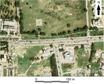
Construction of a new road immediately south of the designated archaeological site in the 1960s saw the destruction of a significant number of ancient buildings; others were subsequently excavated by the Department of Antiquities between the northern road verge and the fenced boundary, where they can be seen today (Figure 1). Several buildings are represented in this area including the remains of a peristyle house perhaps dating back to the early Roman period, with others dating into the fifth century or even perhaps to the period of the Arab conquest.
Google Earth image shows area of excavation (white arrow) and new mosque immediately to the south. The remains of ancient site of Balagrae are north of the road within the enclosure. Area immediately north of road contains buildings excavated by Department of Antiquities in 1960s.
Source: Google Earth © 2021 Maxar technologies.

Circumstances of the discovery
Late in 2017, contractors preparing ground for the building of a new mosque 150 m east of the university campus and some 30 m south of the main Benghazi Road, uncovered fragments of a Roman mosaic pavement and several ashlar blocks indicating the presence of intact archaeological remains. Archaeologists from the university monitoring the development requested that all construction be halted for a brief period, to allow a rapid assessment of the discoveries to be made.
This article provides preliminary results of the assessment, which demonstrated that the area under development contained part of at least one substantial building and the remains were clearly under extreme threat of destruction.
The excavation
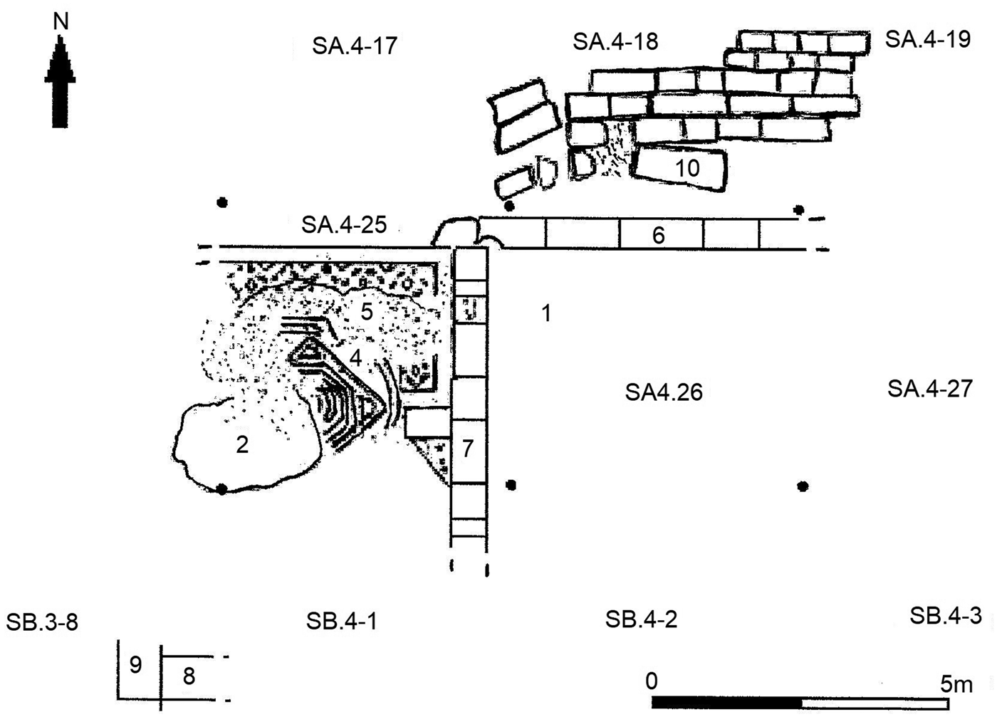
An archaeological watching brief was maintained by members of the Department of Archaeology, Omar al-Mokhtar University, at an early stage of construction activity for the building of a new mosque. During clearance of the site and the machine excavation of a foundation trench, fragments of a mosaic floor were noted in the rubble upcast, together with several ashlar blocks, suggesting the presence of surviving archaeological remains. Accordingly, with the developer's consent, the foundation trench was cleaned and recorded, and two test pits were cut nearby each 2 m x 2 m in extent and set 1 m apart. The initial work was rapidly followed by additional clearance, to identify the limits of a mosaic floor revealed during the assessment and to establish the extent of the surviving building (Figure 2).
Plan of excavated area with numbers of contexts and targeted squares, referred to in text.

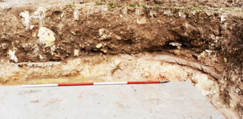
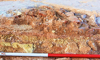
The section exposed in the contractor's foundation trench (Figure 3) and the two test pits exhibited a near-identical sequence of disturbed deposits, comprising a thin covering of topsoil over a 0.5 m thick layer of modern and ancient building debris (1), the product of previous episodes of bulldozing and levelling activities. The disturbance may relate to a previous episode of development in the mid-1950s or peripheral development associated with the construction of the university, established at that time. Sealed beneath the debris was a modern concrete floor (2) which cut into an intact mosaic pavement. The surviving archaeological remains had clearly been disturbed in the recent past by a development which was never completed. Soon after the concrete floor had been laid, the area was abandoned and levelled. It was apparent at an early stage of the work that past ground disturbance was severe against the southern limits of the development and the area of greatest potential lay within the footprint of the new mosque and the area immediately to the north adjoining the highway.
Foundation trench showing remains of a mosaic floor in section. Scale bar 2 m.

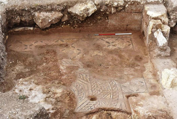
The excavation began by exposing and cleaning a mosaic floor (4), which had decorated a room of which only the northeast corner survived, flanked to the north and east by wall remnants (6 and 7). The mosaic was polychrome, laid in a geometric pattern, and although damaged in antiquity and by the recent development, the main decorative elements were discernible (Figure 3).
A section of mosaic pavement was found beneath an intact compact deposit of brown clay (3) that yielded a mid-fourth century coin, together with fragments of coarse pottery and roof tiles. The surviving mosaic pavement measured approximately 5.20 m east-west by 3.5 m north-south. The original mosaic and the room in which it was laid were of greater size.
The mosaic
The central field of the mosaic floor comprised a circular panel with a diameter of about 0.50 m (now almost completely missing), surrounded by a plain circular band 0.10 m wide, outlined by another circular guilloche band 0.15 m wide, made of yellow, blue, and red limestone tesserae (Figure 4). This was framed by two octagonal plain bands each 0.08 m wide and bordered by an octagonal star made of guilloche 0.16 m wide. The triangles created by the octagonal star were occupied by a chevron pattern made of blue tesserae. This was bordered by a continuous circular guilloche band 0.16 m wide and a single white band separating the design from the frame which was also defined by a white band. The outer field was surrounded by a trellis pattern formed by black quatrefoils set tip-to-tip on a white ground. The centre of each square was decorated with a small diamond motif. The trellis was framed by a narrow black band and a white border 0.35 m wide. The density of tesserae in the field was approximately 64 tesserae per 10 cm2 with an average tessera size of 7 mm2. The density of tesserae in the surrounding white border was approximately 49 tesserae per 10 cm2, with an average tessera size of 10 mm2.
The mosaic floor. Looking north. Scale bar 1 m.

The foundation of the mosaic floor (Figure 5) comprised a basal layer (statumen) 0.20 m thick, of medium sized stones set dry, capped by a 0.08 m thick layer of lime mortar and gravel (rudus). On top of this was a 0.05 m thick layer of lime mortar containing, small, crushed terracotta fragments (nucleus), sealed by a setting bed of fine, soft, white plaster.
Foundation layers beneath mosaic floor, with intact deposits, including pottery and tile (layer 3), capping the mosaic. Scale bar 1 m.

The building
Wall 7, flanking the east side of the mosaic floor, was built in well-cut ashlar blocks of local limestone on average 0.40 m wide, surviving to a maximum height of two courses. Wall 6 was only partially exposed within the test pit adjoining the mosaic, but a single block survived at the intersection of both walls (Figure 4). Later clearance work to the east of wall 7 revealed a 6 m length of wall foundation, with blocks 0.50 m wide and up to 1 m long. The foundation may have been for an external load-bearing wall, with wall 7 forming a partition between two rooms. A possible southern wall or southeast corner for the mosaic room was indicated by two adjacent ashlar blocks (8 and 9) located at clearance level but not excavated. It was not possible to identify the precise function of the room, but the wide, plain border of the mosaic suggested furniture may have been placed against the north and east walls.
To the east of the mosaic room, separated by wall 7, there was a second room. This was only partially excavated, and its form and function cannot be established with any certainty. To the north of the room and wall 6 was an integrated collapse of six courses of ashlar blockwork (10), clearly representing the superstructure of wall 6 that had at some time collapsed, perhaps after an earthquake.
Development pressures precluded further investigation but continuing clearance of the area by the contactors indicated that ground further to the south of the mosque had been badly disturbed by previous development activities and there was little potential for further discoveries.
Discussion
Despite the paucity of evidence, with only parts of two rooms within a single building being excavated, together with the remains of a collapsed load-bearing, external wall, the discovery appeared to have been part of a high-end dwelling. Similar mosaics recorded at Sidi Khrebish, Benghazi, (cf. Michaelides Reference Michaelides1998, 52–55, Mosaic No. 22, Figures 61–63), point to a construction date of the late second or the early third century AD. The coin and pottery found in the intact deposit sealing the mosaic floor (3), provides a terminus post quem for occupation and an abandonment of at least this part of the house in the mid-4th century AD. The collapse of a main load-bearing wall, followed by abandonment at this time suggests this was caused by the great earthquake of 21 July AD 365, whose traces have been identified in the theatre of the sanctuary (Goodchild Reference Goodchild1966) and in buildings to the east of the theatre (Buzaian and Bentaher Reference Buzaian and Bentaher2002).
The finds
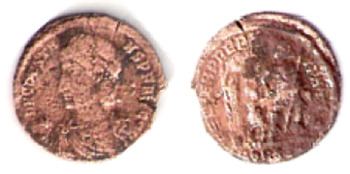
Two coins were recovered during the excavation. The first was unstratified, dating to the reign of Constantinus I (AD 306–337). The second (Figure 6) was found in an intact deposit (3) capping the mosaic. It is of the reverse-type known as FEL TEMP REPARATIO, one of two series issued in the period 350–61 under Constantinus II, Gallus and Julian Caesar (Goodchild Reference Goodchild1966, 211–212). The coin belongs to a type found in a hoard from the sanctuary theatre buried when the theatre was destroyed in the earthquake of AD 365. Deposit 3 also yielded two lamp fragments in a local fabric similar to lamps produced at Tocra, with a discus decorated with a rosette and palm-branch on the shoulder (Riley Reference Riley1983, 241, Pl. LXVII, no. 76), dating into the first half of the third century AD.
Coin found in deposit 3.

Conclusion
The rescue excavation revealed further evidence showing that the overall size of the site of Balagrae is greater than previously thought, extending to the south of the modern Benghazi Road. The Shahat Department of Antiquities excavations conducted in the 1960s following the construction of the modern highway demonstrated clearly that multi-period settlement remains exist immediately south of the guardianship site. Although there are no records of archaeological discoveries during the construction of the university in the 1950s and subsequently, the recent monitoring of construction activities south of the highway and east of the university have revealed traces of at least one building of some quality and demonstrated that further elements of the excavated building and perhaps other multi-period settlement remains, similar to those exposed in the 1960s, also potentially exist in open ground south of the highway.
Protection of the site
Finally, during the watching brief and the evaluation excavation, significant efforts were made by the archaeological team to raise awareness of the site's importance through public engagement. This led to pressure being placed on the developer to preserve the exposed remains and protect the area south of the highway from future development. Consequently, a plan was put forward that was accepted by the developer to reposition the new mosque further to the south, where significant remains had either been destroyed or were absent. The northern perimeter wall of the mosque was positioned to protect the excavated remains and the trenches were carefully backfilled for long-term protection. A thin layer of sieved excavated soil was laid over the mosaic floor and covered with a polyethylene sheet. This sheet was then sealed by a layer of un-sieved topsoil from the surrounding area. The area south of the road has subsequently been designated as public open space. A geophysical survey is proposed to assess the archaeological potential of the area to secure designation and prevent future development.
The significance of the emergency excavation
The emergency excavation was significant for several reasons. First, it proved that the remains of ancient Balagrae extend beyond the known boundaries of the archaeological site, into and under the growing modern city. Secondly, the work was undertaken by the staff and students at the University Department of Archaeology, as part of an organised archaeological watching brief, during a significant local development. Thirdly, as part of that brief following the discovery of archaeological remains, an agreement was reached with the developer to suspend construction activity while an assessment of the discoveries was made. Fourthly, the opportunity was taken to raise public awareness of the discoveries, and this led through community pressure to a redesign of the new building to protect the excavated remains and additionally, to the re-designation of the surrounding area as public open space to protect these and other potentially surviving archaeological remains in future. Whilst these actions are commonplace in many countries, in Libya such episodes and outcomes are rare. They demonstrate a very welcome change in attitude in the local community of al-Baida towards the protection of heritage during schemes for redevelopment.
Acknowledgements
The excavation was organised and funded by Omar al-Mokhtar University, al-Beida, made possible by the support of Dr. Abdel-Matloob Bo-Farwa, the Dean of the University and by Fathalah Khalifa, Head of the Department of Archaeology. Special thanks are extended to Mr Abdullah al-Mabrook, the Inspector of al-Beida Office of the Department of Antiquities and his staff for their immeasurable support. I would like also to express my deep gratitude to the experts of the Judiciary Advisory and Research Centre working in al-Beida Inspectorate Office, including Idris al-Twati, Majdi Mohammed, Saleh al-Talhy, Adulrahman Muftah, Aisa Muftah, Diaa Abdulwahid, Hisham Ahmed and Hasan al-Sifatt for their participation in the fieldwork.