Introduction
Variable rate irrigation (VRI) is attempted to overcome the natural variability in water status found in most fields by applying appropriate amounts of irrigation water to designated areas within a field. Accordingly, its application has a real potential to maximize yield and/or improve irrigation management and thus increase the profitability of the field. To use VRI systems, a field is divided into irrigation management zones (IMZs). Currently, the prescription irrigation maps dividing the field into IMZs are static. As such, they do not respond to varying environmental conditions such as weather patterns and other factors affecting soil moisture conditions, crop growth rates, and dynamic changes in IMZ boundaries. Irrigation water use efficiency can be increased by using dynamic prescription maps where the amount of water assigned to each IMZ changes based on current crop water needs (O’Shaughnessy et al., Reference O’Shaughnessy, Evett and Colaizzi2015; Vellidis et al., Reference Vellidis, Liakos, Porter, Tucker and Liang2016) and by allowing IMZ boundaries to shift based on canopy water status. The crop water stress index (CWSI), which is based on canopy temperature (Jackson et al., 1981), has become an acceptable index to map within-field variability of crop water status using aerial thermal images (e.g. Agam et al., Reference Agam2014; Gonzalez-Dugo et al., Reference Gonzalez-Dugo2013). The CWSI maps can be used as a key input to produce dynamic IMZ maps. Yet, aerial platforms require substantial financial investments that currently inhibit their large-scale adoption. The objective of this paper is to describe future directions to facilitate large-scale adoption of dynamic precision irrigation management based on thermal images (TI), to describe their scientific and engineering basis, and to demonstrate their capabilities with initial results.
Future directions in the delineation of thermal-based dynamic IMZ
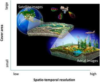
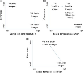
A trade-off exists between satellite and aerial thermal imaging in terms of cover area and spatio-temporal resolution (Figure 1). Satellites provide images covering large areas at a low cost per area unit and have thus became a common tool used by farmers. Currently, satellite-based images in the visible-near-infrared (VIS-NIR) range have a relatively high spatio-temporal resolution, but in the thermal range their finest resolution (90 and 120 m in Landsat-TM and ASTER satellites, respectively) and their long revisit time (every 16 days) are not appropriate for VRI management. On the other hand, aerial-based thermal images, which, theoretically, can be acquired on a daily basis, have high spatial resolution. Yet, they are limited by their cover area (limited capacity), and are thus expensive per area unit. Based on current knowledge and technology three approaches are proposed to produce dynamic IMZ maps, based on TI, that would have adequate spatio-temporal resolution for irrigation management while remaining cost-effective and financially viable: 1) enhancing the spatial resolution of aerial thermal images to increase their capacity; 2) sharpening the spatial resolution of the satellite thermal images by fusing satellite multi-spectral images in the VIS-NIR range; 3) increasing the capacity of the aerial thermal images by fusing satellite multi-spectral images in the VIS-NIR range (Figure 2).
A trade-off exists between satellite and aerial thermal imaging in terms of cover area and spatio-temporal resolution. Image Source: https://news.science360.gov/files/pic-day/7edf814e-cd9c-4c61-877b-86ec831a960a-largeImage.jpg

The proposed approaches to produce dynamic IMZ maps based on thermal images: a) enhance the spatial resolution of aerial thermal images; b) sharpen the spatial resolution of satellite thermal images; 3) increase the capacity of aerial thermal images by fusing VIS-NIR satellite images.

Approach 1: Enhancing the spatial resolution of aerial thermal images (Figure 2a)
The low resolution of the thermal cameras and the short time window appropriate for imaging to detect canopy water status limit the area that can be covered in a single aerial thermal campaign. On the other hand, the time and flight velocity enable image acquisition with large overlapping areas. This overlap can be utilized in a super-resolution (SR) system. The key objective of super-resolution (SR) imaging is to reconstruct a higher-resolution image based on a set of images, acquired from the same imaging system scene and denoted as ‘low-resolution’ images, to overcome the limitation and/or ill-posed conditions of the image acquisition process for facilitating better content visualization and scene recognition (Tian and Ma, Reference Tian and Ma2011). In a SR system based on multiple images of the same area of interest with sub-pixel deviations it is possible to produce an image with a resolution of M x a from M 2 images with resolution a (Mendelowitz et al., Reference Mendelowitz, Klapp and Mendlovic2013; Suresh et al., Reference Suresh, Kumar and Rajagopalan2007). Even in a controlled system, imaging while flying is hard to manipulate to produce sub-pixel overlapping between sequential frames. The system, however, is exposed to random location errors. Alam et al. (Reference Alam, Bognar, Hardie and Yasuda2000) have shown that these errors can be utilized by a gradient-based registration algorithm to estimate the shifts between acquired frames in the thermal range (3–5 μm) followed by a weighted nearest-neighbor approach for placing the frames onto a uniform grid to form a final high-resolution image. Another study has shown that super-resolution restoration may be made also from motionless measurements by wise usage of the optical system, for example by defocus, exploiting different levels of blur (Elad and Feuer, Reference Elad and Feuer1997). Shen et al. (Reference Shen, Ng, Li and Zhang2009) developed a super-resolution image reconstruction algorithm for moderate-resolution imaging spectroradiometer (MODIS) images by utilizing images from sequential days. Developing super-resolution techniques, suitable for aerial thermal imaging systems, will enable aerial imaging from higher altitudes, and thus an increased cover area, without compromising the spatial resolution. In this approach only aerial TI are required and used for the delineation of IMZ prescription maps.
Approach 2: Sharpening satellite thermal images by fusing satellite multi-spectral VIS-NIR images (Figure 2b)
Thermal infrared (TIR) imagery is normally acquired at coarser pixel resolution than that of shortwave VIS-NIR sensors on the same satellite platform. While the TI resolution is not suitable for monitoring crop conditions of individual fields, the spatial resolution of the VIS-NIR images is often fine enough for field and intra-field scales applications (Gao et al., Reference Gao, Kustas and Anderson2012). Consequently, thermal sharpening techniques have been developed to sharpen TI to shortwave band pixel resolutions. A classic thermal sharpening technique, TsHARP, uses a relationship between land surface temperature (LST) and Normalized Difference Vegetation Index (NDVI) developed empirically at the TI pixel resolution and applied at the NDVI pixel resolution (Agam et al., Reference Agam, Kustas, Anderson, Li and Colaizzi2007a and 2007b; Kustas et al., Reference Kustas, Norman, Anderson and French2003). Unique relationships between temperature and NDVI, which enable reliable thermal sharpening, were used mainly over areas with mostly green vegetation and homogeneous air and soil conditions. Gao et al. (Reference Gao, Kustas and Anderson2012) extended the thermal sharpening application by a data mining sharpener and obtained a thermal accuracy of less than 1oC with Landsat TM images.
Although both super-resolution restoration and thermal sharpening aim at increasing spatial resolution, the first utilizes images from a single source with a single spatial resolution, while the second exploits fusion of multiple sensors with multiple spatial resolutions. The Landsat revisit time (16 days) is not suitable for irrigation management, thus weakening the applicability of the sharpening approach. However the revisit time of the new satellites Sentinel 2 and 3 may be suitable to this end. The two in-orbit Sentinel 2 satellites have 13 shortwave bands most of them with 10–20 m spatial resolution and with 3–5 days revisit time. The two in-orbit Sentinel 3 satellites have 2 thermal bands with a spatial resolution of 1000 m, 6 VIS-NIR bands with 500 m and a revisit time of 2 days. Enhancing the spatial resolution of the thermal band by an order of magnitude with satisfactory accuracy is challenging and will be examined. In any case, this approach will be appropriate only for large plots (>100 ha) since the resolution of the thermal image should be larger than the plot size to make a reliable sharpening (Agam et al., Reference Agam, Kustas, Anderson, Li and Neale2007b).
Approach 3: Increasing the capacity of aerial thermal images by fusing satellite multi-spectral VIS-NIR images (Figure 2c)
The two previous approaches directly targeted the spatial resolution enhancement challenge, and the increase in cover area was a by-product of the process. Also, each of the two previous approaches targeted either aerial or satellite images. The third approach directly targets the challenge of increasing the cover area by fusing aerial thermal images with shortwave satellite images. In this approach it is suggested to correlate between thermal indices like the CWSI, which are known to be linearly correlated to plant water status, and vegetation indices (VIs) in the VIS-NIR range. While VIs in the VIS-NIR range are not directly correlated to water status, especially during the reproductive phase, linear correlations between VIs and water status exist provided that the analyzed scene includes both pixels representing high water deficits and well-watered conditions Rapaport et al. (Reference Rapaport, Hochberg, Shoshany, Karnieli and Rachmilevitch2015). Accordingly, if thermal and VIS-NIR images are available for a relatively large area encompassing a broad range of crop water status, it is assumed that good correlations will be found between the two types of images. To utilize the high spatial resolution of airborne TI and overcome the relatively small extent of their spatial coverage, while assuring the capture of a wide range of water status, it is proposed that isolated sets of images across a large area will be acquired instead of scanning a continuous but limited area. The sampling areas will be determined by analyzing the variability in satellite VI images that will be acquired a few days before the aerial campaign. The regression models could then be used to create water status maps with spatial resolutions of 2–30 m and applied to large areas eliminating the need to collect thermal images from every field.
Initial results
Approach 1: Enhancing the spatial resolution of aerial thermal images
One way to enlarge the capacity of aerial imaging with a given sensor resolution is either by imaging from higher altitude (So) or lowering the system focal length (f) by replacing the lens. In aerial imaging typically acquired at heights of hundreds to thousands of meters, with focal length of a few tens of millimeters, image magnitude size approximately equals f/So. Thus enlarging So or reducing f by a factor of 2 quadrates the size of the covered area in the price of reducing the spatial resolution by factor of two in each direction. This resolution reduction increases the mixed pixel effect, resulting in an error in the gray level value and a consequent error in the temperature estimation.
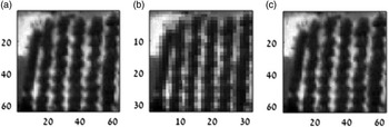
An aerial-based TI from a date-palm orchard acquired by FLIR SC655 (FLIR Ltd.) is presented in Figure 3a. Figure 3b presents the TI with reduced spatial resolution resulted from simulating the enlargement of the field of view by two. The differences between the two TIs in terms of mixed pixels and gray level are clear. A supper resolution restoration relied on 4 images of coarse resolution level (Figure 3b) is presented in Figure 3c. The restoration was conducted by shifting each image in a magnitude of half pixel in two directions. Under ideal conditions of accurate motion estimations and noise free images the standard deviation of the differences between the original TI and the restored TI was negligible (1e−7). The implementation of this method in real world accuracies is examined.
a) Real low-altitude TI; b) simulated TI from high altitude (lower resolution in comparison to a); c) Restored TI based on four high-altitude TIs.

Approach 3: Increasing the capacity of aerial thermal images by fusing satellite multi-spectral VIS-NIR images
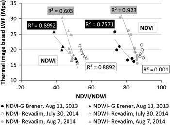
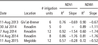
In a framework of multiple studies which developed methodologies to use TIs for variable irrigation management in cotton, ground and airborne based thermal images were acquired over commercial cotton fields (Rosenberg et al., Reference Rosenberg, Cohen, Saranga, Levi and Alchanatis2013, Reference Rosenberg, Alchanatis, Cohen, Saranga and Bosak2014 and Reference Rosenberg, Cohen, Alchanatis and Saranga2015). Five thermal imaging campaigns from 2013, 2014 and 2015 cotton growing seasons that coincided with the passage of Landsat TM were selected. The TIs were converted into CWSI and leaf water potential (LWP) following Cohen et al. (Reference Cohen2015). Landsat TM images were converted into NDVI (Tucker, Reference Tucker1979) and NDWI (Gao, Reference Gao1996) maps. The correlations between aerial thermal based LWP maps and satellite VI images of irrigation units were examined. Relatively high linear correlations were found between LWP and either NDVI or NDWI for all five campaigns (Figure 4; Table 1). Using the regression models in each date enables mapping of CWSI and LWP in cotton fields over a much larger area than the original area covered by the aerial campaign. These initial results demonstrate the potential in using this approach to enlarge the cover area of reliable thermal-based dynamic IMZ maps. As assumed, since the regression models are not constant the correlations will need to be built separately for each campaign.
Relationships between Landsat-TM NDVI and NDWI with thermal-based LWP in three different dates.

The correlations between aerial thermal based LWP and satellite VI in five campaigns

Conclusions
Three approaches were presented to enhance the usability of thermal-based dynamic management zones for variable rate-irrigation. The first two approaches, i.e. the super-resolution and the sharpening approaches, aim at increasing spatial resolution of either airborne or satellite TIs. The super-resolution approach utilizes images from a single source with a single spatial resolution, while the sharpening exploits fusion of multiple sensors with multiple spatial resolutions. The third approach directly targets the challenge of increasing the cover area by fusing aerial thermal images with shortwave satellite images. The scientific basis of the three approaches was briefly described and initial results for the first and the third approach was presented to demonstrate their potential in creating thermal-based in-season IMZ maps. The performance of all suggested approaches should be assessed by extensive imaging campaigns and ground experiments.
Acknowledgments
This research was supported by grant No. 20-12-0030 from the Chief Scientist of the Israeli Ministry of Agriculture.