1. Introduction
The upper Firth of Clyde (hereinafter ‘the upper Firth’; Fig. 1, NE block) is enclosed on three sides by uplands that owe their origins to tectonic and tectono-magmatic events of widely disparate age and kind. The Renfrewshire–Kilbirnie Hills to the E are formed by the largest, thickest and most westerly fault block of the Early Carboniferous Clyde Lava Plateau (Geikie, Reference Geikie1897). They share an Upper Palaeozoic bedrock foundation beneath the lavas (Fig. 2) with the southern half of the Isle of Bute and the Cumbrae islands, and all lie within the terrane formed by the Midland Valley of Scotland (MVS). In contrast, the two other uplands – that to the NW extending continuously from Kintyre to Lomondside and that to the SW much more localized in northern Arran – are formed, respectively, of Dalradian metasedimentary rocks of Neoproterozoic and Early Palaeozoic age and granites of early Cenozoic age, and both lie within the Central Highlands or Grampian terrane (British Geological Survey, 1987, Reference Pharaoh, Morris, Long and Ryan1996a ; Stephenson et al. Reference Stephenson, Mendum, Fettes and Leslie2013). These older and younger rocks record historical events that influenced tectonic development in the upper Firth but, respectively, preceded and succeeded the main events responsible. In its basic physiography, therefore, the upper Firth gives expression to an eventful and lengthy geological history.
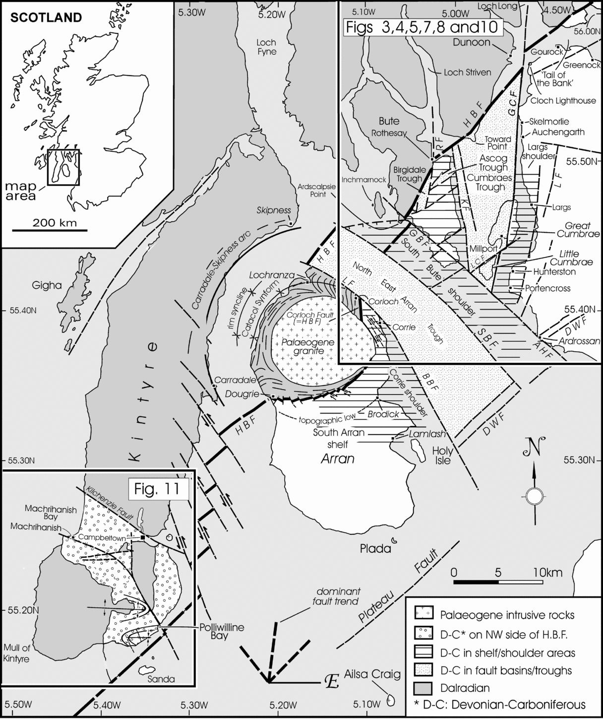
Geological sketch map of the greater part of the Firth of Clyde and environs. The block in the NE corner conforms approximately to the ‘upper’ Firth of this paper, with parts further illustrated in Figures 3, 4, 5, 7, 8, 10 and 11. The block in the SW corner illustrates the only relevant part of the remote outer Firth. Trends of the key groups of faults responsible for the fracture grid imposed on the upper Firth are shown near the bottom of the figure. Abbreviations: AHF – Ardrossan Harbour Fault; BBF – Brodick Bay–Laggan Fault; DWF – Dusk Water Fault; GBF – Glencallum Bay Fault; GCF – Great Cumbrae Fault; HBF – Highland Boundary Fault system; KF – Kerrycroy Fault; LF – Largs Fault system; LCF – Little Cumbrae Fault; RF – Rothesay Fault. The Plateau Fault is believed to be an extension of the Dusk Water Fault.

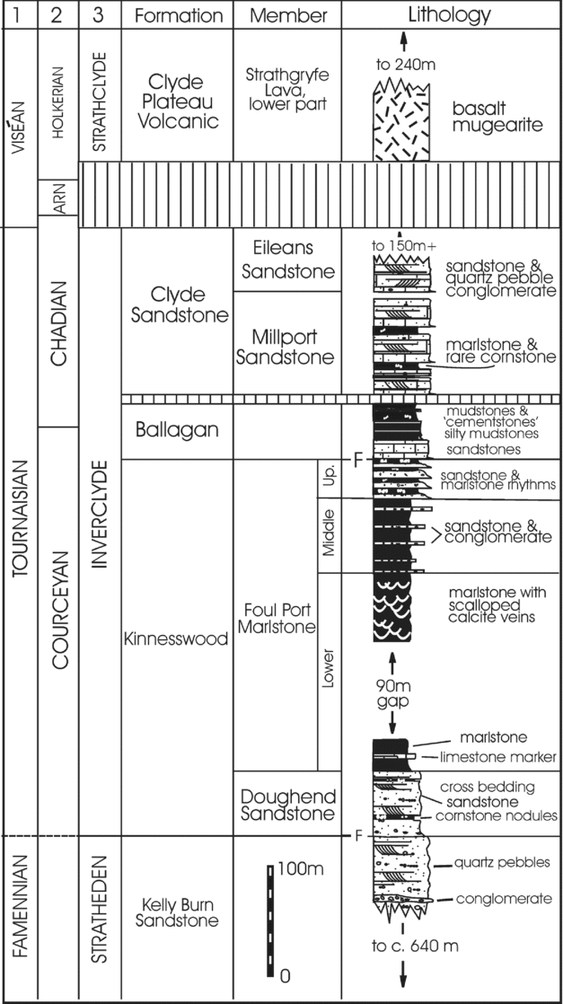
Stratigraphical column of the Upper Devonian and Lower Carboniferous rocks in the Cumbraes basin. Allowing for lithostratigraphical variations, the section is widely applicable to the area under investigation, except in mid-Bute (Ascog and Birgidale troughs) and NE Arran (coastal section near Laggan) where thin argillaceous developments – the Birgidale Formation (<30 m) in Bute; the Laggan Cottage Mudstone (<18 m) in Arran – lie above the Arundian – early Holkerian unconformity and are succeeded directly by the Clyde Plateau lavas. For further information on these thin, argillaceous developments and on the lithostratigraphical succession generally, see Paterson & Hall (Reference Paterson and Hall1986, table 1, figs 1–3), Browne et al. (Reference Browne, Dean, Hall, McAdam, Monro and Chisholm1999, p. 13, figs 1, 2), Dean et al. (Reference Dean, Browne, Waters and Powell2011, p. 23, fig. 6), Young & Caldwell (Reference Young and Caldwell2011c , figs 1, 14; Reference Caldwell and Young2012, fig. 4) and Figure 7. Abbreviations: ARN – Arundian. F – faulted contact. 1 – stage; 2 – substage; 3 – group.

North of the upper Firth, the southwesterly trending Highland Boundary Fault (HBF), separating the Grampian and Midland Valley terranes, is a composite fracture (Qureshi, Reference Qureshi1970; McLean, Deegan & Wren, Reference McLean, Deegan, Wren, McLean and Deegan1978; Paterson, Hall & Stephenson, Reference Paterson, Hall and Stephenson1990; British Geological Survey, 1985, Reference Pharaoh, Morris, Long and Ryan1996a , 2008), with the key components uniting and bending to a more southerly course through Bute. Thereafter, fragmented by a group of northwesterly trending faults with strong strike-slip displacements, the HBF is believed to follow a disjointed course through Arran to the Mull of Kintyre (Young & Caldwell, Reference Young and Caldwell2012), resulting in an anomalous narrowing of the Midland Valley (British Geological Survey, Reference Pharaoh, Morris, Long and Ryan1996a ). As with the physiographical setting, this points to important differences in tectonic history and calls for further investigations of the Firth of Clyde area on both local and regional scales.
The tract of the MVS between the HBF and the parallel Dusk Water Fault is central to the present study, with westward extension of the latter fault from Ardrossan giving arbitrary southerly delineation to the ‘upper’ Firth (Fig. 1). Within this tract, (a) a group of faults parallel to the HBF played an important role in positioning the Clyde Plateau volcanic outliers of Little Cumbrae and south Bute (Caldwell & Young, Reference Caldwell and Young2011); (b) a group of NW-trending faults, first recognized in south Bute (Boué, Reference Boué1820; Bryce, Reference Bryce1872), includes those that define the North-East Arran Trough (McLean & Deegan, Reference McLean, Deegan, McLean and Deegan1978) to the SW and is present on both Cumbrae islands to the NE; and (c) a group of faults, N to NNE in orientation, sharply separates the upper Firth from the adjoining mainland (Caldwell & Young, Reference Caldwell and Young2012, fig. 11). The fault parallel to the E coast of mid-Bute that, together with the Great Cumbrae Fault, defines the Cumbraes Trough (Young & Caldwell, Reference Young and Caldwell2012) is included in this last group (Fig. 1). These three groups form a regional grid that has controlled stratigraphical sequence, outcrop distribution and geomorphological expression – the last suggested in particular by the degree to which coastal lineaments and faults have common orientations. Trends of the basic grid lines, shown in Figure 1, fit well with the triangle of lineaments shown by Trewin & Rollin (Reference Trewin, Rollin and Trewin2002, fig. 1.9).
A fourth group of faults, aligned E to ENE, has relatively modest representation and does not affect the regional grid. These faults record a brief extensional episode that immediately preceded the Late Carboniferous (terminal Westphalian) tholeiitic event, when long, thick dykes of quartz dolerite were injected into the fractures to create a swarm across midland Scotland and into the North Sea (see, for example, Cameron & Stephenson, Reference Cameron and Stephenson1985, fig. 35).
All groups of faults developed during the Caledonian–Variscan interlude of Late Palaeozoic time (Francis, Reference Francis, Bowes and Leake1978a , Reference Francis, Ramberg and Neumann b ; Read et al. Reference Read, Browne, Stephenson, Upton and Trewin2002; Goodenough, Stephenson & Loughlin, Reference Goodenough, Stephenson, Loughlin, Stephenson, Loughlin, Millward, Waters and Williamson2003; Upton et al. Reference Upton, Stephenson, Smedley, Wallis, Fitton, Wilson, Neumann, Davies, Timmerman, Heeremans and Larsen2004; Macdonald & Fettes, Reference Macdonald and Fettes2007) and all, except those accommodating the quartz-dolerite dykes, underwent recurrent rejuvenation.
The rocks of the upper Firth have also been deformed by two sets of open plunging folds, the axial trend of one approximately N–S, the other slightly N of E, and with both exhibiting considerable variation about their vector mean values. The deformation may have accompanied faulting (Anderson, Reference Anderson1951, pp. 173–8), the setting of some folds encouraging such an interpretation, others not, and with inadequate information otherwise available to resolve the question convincingly. Few folds have been recorded previously – those of the Cumbrae islands the most notable exceptions (Geikie, Reference Geikie1897, fig. 107; Gunn, Reference Gunn, Gunn, Geikie, Peach and Harker1903, fig. 2; Caldwell, Reference Caldwell and Campbell1975; Figs 3, 4) – but folds now have been recognized at many localities, calling for consideration of their role in the Firth's deformational history. In the analysis that follows, therefore, the folds are treated separately from the faults, and both sets examined in much the same way as the major groups of faults, with attention being given to key illustrative examples.
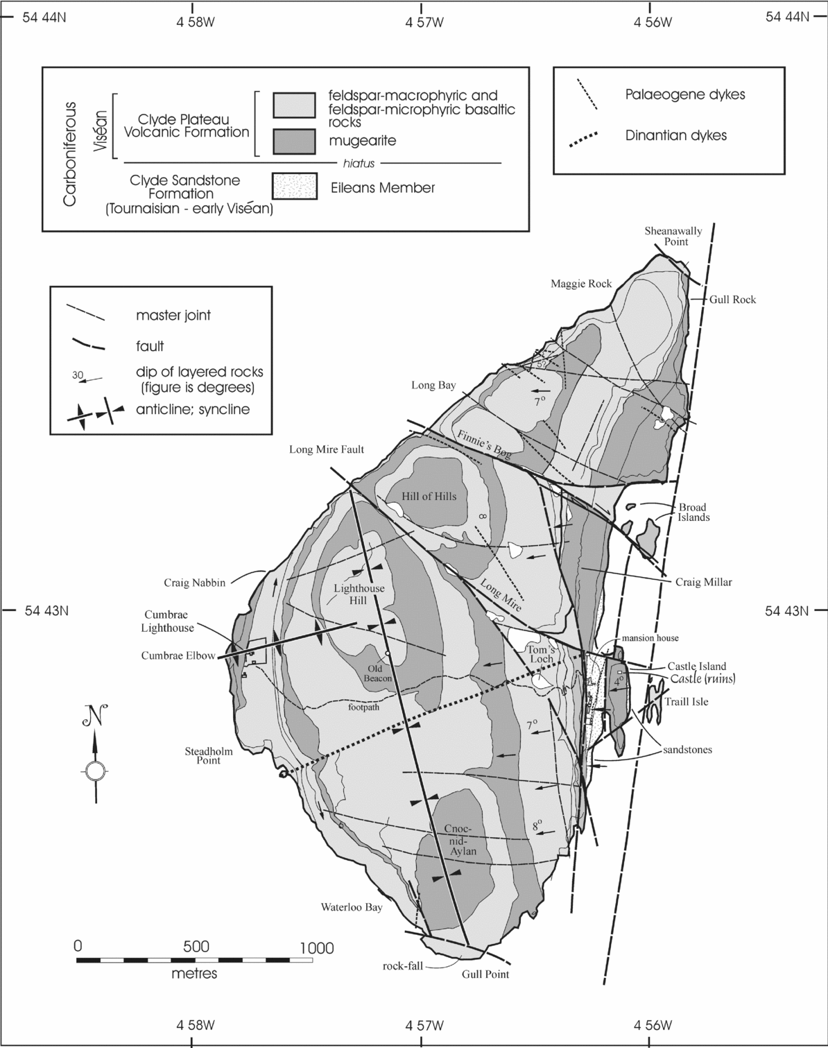
Geological map of Little Cumbrae. Reproduced by permission of The Royal Society of Edinburgh from Earth and Environmental Science Transactions of the Royal Society of Edinburgh, volume 102.1 (2011), pp. 59–76.

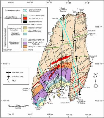
Geological map of Great Cumbrae. Note, in particular (a) the fragmentation of the NE-trending Craignan Fitheach and Millport Bay faults, the former with a net dextral displacement by c.1 km on the Great Cumbrae Fault; (b) the evidence of repeated rejuvenation of the N-trending Great Cumbrae Fault in the form of displacement of dykes of different ages, which illustrates the kinds of relationships found elsewhere on the island on varying scales and involving all major groups of faults; and (c) the relative importance of faults over folds in determining the geomorphic form of Millport Bay and of local embayments on the S and W coasts (in the last respect, cf. Fig. 5). Reproduced by permission of The Royal Society of Edinburgh from Earth and Environmental Science Transactions of the Royal Society of Edinburgh, volume 102.4 (2012, for 2011), pp. 227–51.

High-precision numerical dating by Monaghan & Pringle (Reference Monaghan, Pringle, Wilson, Neumann, Davies, Timmerman and Larson2004) and Monaghan & Parrish (Reference Monaghan and Parrish2006) and compatibility of their findings with stratigraphical ages to the level of the stage have permitted more refined correlation of Carboniferous rocks in the region of study. Their ages are adopted in this study.
With reference to the upper Firth, therefore, this paper has the objectives of:
(1) analyzing and interpreting the history of the major groups of faults that shaped the geology and apparently much of the geomorphology;
(2) refining the history of fault movement between Early Carboniferous and middle Palaeogene times by using displacements of primary and secondary dyke swarms and individual dykes within them;
(3) analyzing the distribution and origin of the folds and their implications for tectonic evolution; and
(4) collating these results in a context of regional tectonic events to derive the most plausible tectonic history for the northerly portion of the offshore western MVS.
To meet these objectives, the Cumbrae islands and the south Bute promontory were remapped on a scale of 1:10560, parts on a scale of 1:2535, and other parts of the upper Firth were remapped on comparable or smaller scales as required (see Figs 3–5, 7, 10, 11).
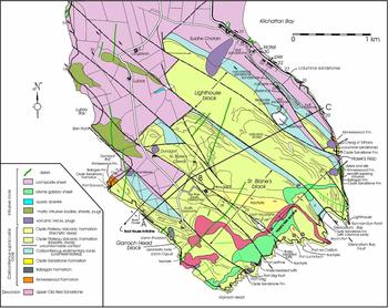
Geological map of the promontory of south Bute. Note in particular (a) the two sheets or sills running along the S coast which largely control topography and orientation of that coastal belt; (b) prominence of the NW-trending faults and their role in forming the lava-capped half-graben grouped into ‘blocks’; (c) the stepped nature of the NE-trending Kilchattan Bay Fault due to displacements on NW-trending faults. This fault originally may have juxtaposed the geologically discrete south Bute promontory against the adjoining part of the island further N. Thin wavy lines in the lavas (green) denote the scarps of successive lava flows. All lavas are believed to correlate to the Strathgryfe and Misty Law Trachytic members of the Clyde Plateau Formation in the Renfrewshire Hills (Caldwell & Young, Reference Caldwell and Young2011).

2. Structures of the Upper Firth of Clyde I: faults
The sharply triangular shape of Little Cumbrae and the conformity of its coastal orientations to those of the three major groups of faults strongly suggest that the island is entirely fault bound (Figs 1, 3). Moreover, given that the three groups are known to have moved repeatedly during the Carboniferous Period, the defining structural lines of the island could well have been imposed on the Lower Strathgryfe Lavas of the Clyde Plateau Volcanic Formation (hereinafter ‘Clyde Plateau Formation’), which form the island, shortly after they were spread westward from the mainland (Caldwell & Young, Reference Caldwell and Young2011). Such a notion is supported by McLean & Walker's (Reference McLean, Walker, McLean and Deegan1978) magnetic survey of the upper Firth, which reveals the lavas to extend little beyond the island's present limits. Little Cumbrae, therefore, makes a convenient and logical starting point for examination of the three major groups of faults.
2.a. NE-trending faults
The NW coast of Little Cumbrae parallels the faults of northeasterly orientation. Among these, the HBF and the Dusk Water Fault are the most important in the upper Firth, and lesser faults of similar orientation occur between them. Faults in this group probably were initiated at different times. The HBF may date to Early Palaeozoic time (George, Reference George1960), the prototypic Dusk Water to some later phase of the Caledonian Orogeny, and the lesser faults to reactivation of pre-existing lines of weakness or adjustment to proto-Variscan stresses imposed on an area of strong caledonoid ‘grain’. As a generalization, most NE-trending faults in the upper Firth that underwent post-Caledonian–pre-Variscan movements were controlled to some degree by rejuvenation of ancestral caledonoid structures (Kennedy, Reference Kennedy1958; Francis, Reference Francis, Bowes and Leake1978a , Reference Francis, Ramberg and Neumann b ; Upton, Reference Upton and Sutherland1982; Goodenough, Stephenson & Loughlin, Reference Goodenough, Stephenson, Loughlin, Stephenson, Loughlin, Millward, Waters and Williamson2003).
Inactivity of the HBF during the Carboniferous Period (George, Reference George1960; Upton, Reference Upton and Sutherland1982) is not supported by stratigraphical relationships in the upper Firth. In the Toward Point outlier, the fault throws a condensed succession of the Tournaisian Inverclyde Group against Dalradian rocks (British Geological Survey, 2008), and in central Bute, components of the HBF system and other subparallel faults define outliers of Dinantian rocks in a succession different from that elsewhere on the island. This suggests that the faults were active during deposition of sediments and extrusion of lavas of Dinantian age. In west-central Bute, furthermore, rocks of the Highland Border Complex are associated with sedimentary rocks attributed to the Inverclyde Group on the N side of Scalpsie Bay (British Geological Survey, 2008; Chew et al. Reference Chew, Daly, Magna, Page, Kirkland, Whitehouse and Lam2010; Young & Caldwell, Reference Young and Caldwell2011c ). The other major NE-trending fault, the Dusk Water, is known to have undergone repeated movement during the Carboniferous Period, as shown by its syndepositional record (see, for example, Cameron & Stephenson, Reference Cameron and Stephenson1985; Monro, Reference Monro1999).
2.a.1. Lesser caledonoid faults in the upper Firth
Several northeasterly faults are present in and adjacent to south Bute and the Cumbraes, although records of their movements are generally less clear than those of the other two groups of faults that displaced them during repeated reactivation.
In terms of delineating the NW coast of Little Cumbrae, the submarine fault located a short distance off the S coast of south Bute and detected by various geophysical surveys (Deegan, Reference Deegan, McLean and Deegan1978, fig. 5.1; McLean & Walker, Reference McLean, Walker, McLean and Deegan1978, fig. 3.1; McLean & Deegan, Reference McLean, Deegan, McLean and Deegan1978, fig. 8.1) is a strong contender. It bridges the NW-trending Ardrossan Harbour – Glencallum Bay and Sound of Bute faults (Figs 1, 8), where it defines the northward limit of a patch of igneous rocks responsible for a magnetic anomaly recorded by McLean & Wren (Reference McLean, Deegan, Wren, McLean and Deegan1978, fig. 2.5). This patch may well be a faulted repetition of the igneous rocks present on the adjacent south Bute coast (Fig. 5). Following slight offset resulting from net shear displacement on the Ardrossan Harbour – Glencallum Bay Fault (Young & Caldwell, Reference Young and Caldwell2012), it then extends northeastwards as the Little Cumbrae Fault in strict parallelism and close proximity to the NW coast of Little Cumbrae island. That the South Bute Fault identified by McLean and Deegan was not originally mapped to the NE of the Ardrossan Harbour – Glencallum Bay Fault is scarcely surprising: few geophysical observation sites were permitted across the main shipping channel of the upper Firth, and the contrast between juxtaposed rock types is lost NE of the Ardrossan Harbour – Glencallum Bay line (Deegan, Reference Deegan, McLean and Deegan1978, pp. 61, 63; McLean & Deegan, Reference McLean, Deegan, McLean and Deegan1978, fig. 8.1).
The ENE submarine fault on the N side of Kilchattan Bay, south Bute (McLean & Deegan, Reference McLean, Deegan, McLean and Deegan1978, fig. 8.1; Figs 1, 5) may continue WSW beneath raised-beach deposits of the Kilchattan–Stravannan lowlands (Geological Survey of Scotland, 1897; British Geological Survey, 2008). More probably, however, it is the northeasterly extension of the fault already traced across south Bute from the south side of Dunagoil Bay (Young & Caldwell, Reference Young and Caldwell2011c ; Fig. 5). The fault's role in determining the northward limit of the Clyde Plateau lavas in the various fault blocks of the promontory was probably owing to late- or post-Viséan rejuvenation, involving also the northwesterly faults that displaced it. The Kilchattan Bay Fault may extend northeastwards to cross Great Cumbrae from about Bell Bay to Ferry Hole (Fig. 4), where a fault is suspected on broad stratigraphical and topographical grounds but cannot be delineated within acceptable limits of accuracy.
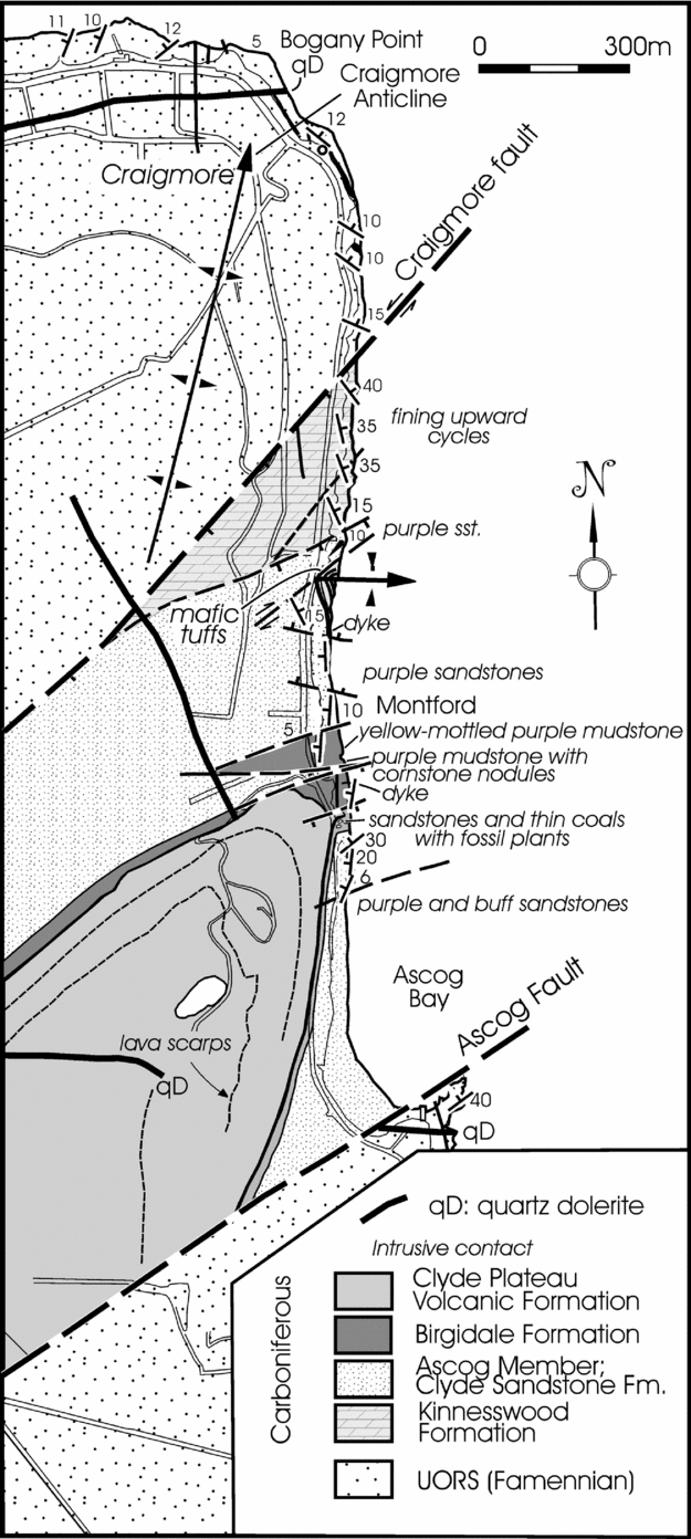
Still farther N in Bute, the Ascog and Craigmore faults define the wedge-like Ascog Block of rocks ranging as high as the Clyde Plateau lavas (Fig. 7). Other caledonoid faults in mid-Bute include the Scalpsie Bay Fault, which in crossing the island with a more easterly orientation obliquely truncates the western end of the HBF sensu stricto (Young & Caldwell, Reference Young and Caldwell2011b , fig. 1).
The most prominent northeasterly fault on Great Cumbrae is the Craignan Fitheach Fault, which extends from the intrusion of that name on the W coast to Clashfarland Point on the E (Caldwell & Young, Reference Caldwell and Young2012, fig. 9; Fig. 4). This structure again illustrates later displacement by northwesterly faults and provides evidence of early, dextral, displacement on the Great Cumbrae Fault. A caledonoid fault that crosses Millport Bay is also repeatedly cut by northwesterly faults, as shown by displacement of the Clyde Street Sill (Caldwell & Young, Reference Caldwell and Young2012, section 1.2; Fig. 4).
2.a.2. Origin and age span
Although all three groups of faults began to move in response to proto-Variscan stresses in Late Devonian time, the NE-trending group was probably the first to do so as at least its major members developed on the sites of reactivated Caledonian structures (Bluck, Reference Bluck, Bowes and Leake1978, Reference Bluck, Reading and Balance1980, Reference Bluck, Friend and Williams2000; Francis, Reference Francis, Bowes and Leake1978a , Reference Francis, Ramberg and Neumann b ; Upton, Reference Upton and Sutherland1982; Read et al. Reference Read, Browne, Stephenson, Upton and Trewin2002; Goodenough, Stephenson & Loughlin, Reference Goodenough, Stephenson, Loughlin, Stephenson, Loughlin, Millward, Waters and Williamson2003). The same group may also have been the first to become inert under a cover of as much as 5 km of Carboniferous sedimentary and volcanic rocks (Guion, Gutteridge & Davies, Reference Guion, Gutteridge, Davies, Woodcock and Strachan2000). This applies to many of the lesser NE-trending faults detected in south Bute and the Cumbraes where only the Little Cumbrae Fault points to Late Carboniferous or post-Carboniferous movements in its displacement of the Great Cumbrae Fault. In contrast, some major faults in this category were reactivated repeatedly during the Carboniferous Period, as shown by the syndepositional record of the Dusk Water Fault (Richey, Anderson & MacGregor, Reference Richey, Anderson and MacGregor1930; Hall, Reference Hall1974; Monro, Reference Monro1999). Furthermore, if this fault extends across the entire Clyde Basin, partly in the guise of the Plateau Fault of McLean & Deegan (Reference Deegan, McLean and Deegan1978, fig. 8.1; see also McLean & Wren, Reference McLean, Deegan, Wren, McLean and Deegan1978, figs 2.7, 2.8; British Geological Survey, 1985), as suggested by Young & Caldwell (Reference Young and Caldwell2012), movements were perpetuated well into Mesozoic and even Cenozoic times because the Plateau Fault brings Permian sandstones into contact with Mesozoic (and possibly Cenozoic) rocks in the South-West Arran Trough.
2.b. NW-trending faults
Faults in this category are more common in the median and western parts of the MVS than in the eastern part (Anderson, Reference Anderson1947), and they are concentrated in the upper Firth. Important members include the Ardrossan Harbour, Sound of Bute and Brodick Bay faults (McLean & Deegan, Reference McLean, Deegan, McLean and Deegan1978, figs 2.6, 5.1, 8.1; Cameron & Stephenson, Reference Cameron and Stephenson1985, figs 17, 21; British Geological Survey, 1985). Young & Caldwell (Reference Young and Caldwell2012) underscored the importance of this group in the Clyde Basin with reference to shear displacement of the HBF and other NE-trending caledonoid fractures and to growth of Late Palaeozoic depositional troughs. The following discussion addresses supplementary information and concentrates on faults in the upper Firth.
2.b.1. Faults of the upper Firth
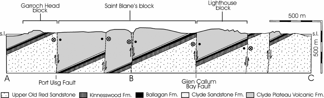
The SW coast of Little Cumbrae lies close and parallel to one of the most regionally important members of the NW-trending group of faults: the Ardrossan Harbour Fault, which on the basis of geophysical data extends NW to enter south Bute at Glencallum Bay (Fig. 1). It is one of several such faults that divide the south Bute promontory into a series of small, unnamed, tilted fault blocks in which the layered rocks dip to the WSW. These in turn have long been grouped into three larger, named blocks (Figs 5, 6). The small tilted fault blocks are capped by lavas assigned to the Strathgryfe Member of the Clyde Plateau Formation, which lie disconformably on the lower member of the Clyde Sandstone Formation (Figs 2, 6). The Inverclyde Group is much condensed relative to the sequence in adjacent Great Cumbrae, implying rapid thinning on the south Bute shoulder, as suggested by Young & Caldwell (Reference Young and Caldwell2012) (see also Caldwell & Young, Reference Caldwell and Young2011; Fig. 1, and cf. Fig. 6 to British Geological Survey, 2008, cross-section 3). The promontory of south Bute is the most instructive part of the upper Firth for study of the northwesterly fault group.
Geological cross-section of the south Bute promontory along line of section A–B–C in Figure 5 to show the disposition of the half-graben that compose the promontory and their allocation to the three major ‘blocks’ (Lighthouse, St Blane's and Garroch Head).

Lesser faults in the group are present on both Cumbrae islands. On Little Cumbrae, they maintain the strict northwesterly trend of those in south Bute and differ only in their reversal of direction of downthrow (Figs 3, 5). On Great Cumbrae, they are more north-northwesterly in orientation and become progressively more so eastwards towards the Great Cumbrae Fault (Fig. 4). Faults of this group reveal a mix of net dextral and sinistral displacement (sinistral slightly more common). With the exception of the Finnie's Bog Fault (Fig. 3) and the Foul Port Fault (Fig. 4), the sense of movement on the northwesterly faults of the Cumbraes is difficult to decipher, and the presence of small shear components is commonly detected only by displacements of dykes and other faults. The strongest concentration of northwesterly faults on Great Cumbrae is around Millport Bay. Small splays radiate from the main NW-trending faults between Foul Port and Knox's Port and, in the centre of the bay, small faults of the same orientation are countered by similar northeasterly ones to produce a localized pinnate arrangement of fractures. This is apparently responsible for the position and shape of the Eileans and the other smaller islets of the bay (excepting the Clach), and the alignment of the Eileans with the sand-covered bedrock ridge of The Rigg, which links them to the shore (Lytteil, Reference Lytteil1886; UK National Hydrographic Service, 2007; Fig. 4).
The overall impression conveyed by the NW-trending faults of south Bute and the Cumbraes is of a system of fractures gradually changing in orientation eastwards from NW to NNW and concurrently weakening in magnitude of displacement, ultimately giving way to the Great Cumbrae – Largs system of N-trending faults that dominates the nexus between the mainland and the upper Firth.
2.b.2. Origin and age span
The origin of the NW- to NNW-trending faults in the western offshore MVS is not immediately evident because early movements have been masked or obliterated by rejuvenation that persisted into the Palaeogene Period. Until quite recently, the northwesterly faults in the coastal mainland were commonly thought of as originating during the later Carboniferous Period in response to culminating Variscan stresses. Undoubtedly many did, when older faults were rejuvenated with concurrent generation of new faults of similar trend, and this kind of proliferation evidently continued into Permian times (Mykura, Reference Mykura1967; Francis, Reference Francis, Ramberg and Neumann1978b ; Paterson, Hall & Stephenson, Reference Paterson, Hall and Stephenson1990, p. 38).
Better evidence of an original age for the northwesterly faults and how they behaved after initiation, however, comes from the Sound of Bute, where the cuneate North-East Arran Trough (McLean, Reference McLean, Bowes and Leake1978, fig. 1; McLean & Deegan, Reference McLean, Deegan, McLean and Deegan1978, pp. 108–9, fig. 8.1; Fig. 1) is bound northeastwards by the Sound of Bute Fault and southwestwards by the Brodick Bay – Laggan Fault. The trough narrows northwestwards and, prior to becoming distorted by emplacement of the North Arran Granite Pluton (Woodcock & Underhill, Reference Woodcock and Underhill1987; England, 1982), the two boundary faults converged on the entrance to Loch Fyne. The southeasterly end of the trough may have been truncated initially, or later, by seaward extension of the NE-trending Dusk Water Fault or the parallel faulted extension of the Paisley Ruck, as Young & Caldwell (Reference Young and Caldwell2012) favoured, or have been bevelled by extension of the N-trending Great Cumbrae Fault, as McLean & Deegan (Reference Deegan, McLean and Deegan1978, fig. 8.1) suggested. The controlling influence of the NW-trending boundary faults on accumulating sediments of the Inverclyde Group (Figs 1, 2) and possibly even of the Old Red Sandstone (Famennian) was discussed by Young & Caldwell (Reference Young and Caldwell2012). Such early influence is suggested also by movements of the Largs–Hunterston faults on the eastern shoulder of the Cumbraes Trough during deposition of the Kelly Burn sands of the Stratheden Group (Section 2.c.3 below).
McLean (Reference McLean, Bowes and Leake1978) and McLean & Deegan (Reference Deegan, McLean and Deegan1978, p. 108) linked the North-East Arran Trough to similarly aligned structures, such as the Stranraer, Mauchline, Sanquhar, Thornhill and Dumfries basins in the Southern Uplands, which trend towards the Vale of Eden (Hall, Reference Hall1974; Francis, Reference Francis, Bowes and Leake1978a , Reference Francis, Ramberg and Neumann b ). Some of these also subsided along northwesterly axes and faults in Late Carboniferous time, others more pronouncedly in Permian–Triassic (New Red Sandstone) time (Bott & Masson-Smith, Reference Bott and Masson-Smith1960, p. 330; McLean, Reference McLean1961, p. 126; Mykura, Reference Mykura1967, p. 87; Francis, Reference Francis, Bowes and Leake1978a , Reference Francis, Ramberg and Neumann b ).
The New Red Sandstone of the South-West Arran Trough and that of the North Channel Basin, S of the Mull of Kintyre, includes deposits of Triassic age (some in Upper Triassic Keuper facies) and, in places, overlying undifferentiated Mesozoic–Cenozoic deposits, all of which are cut by NW- to NNW-trending faults (McLean & Deegan, Reference McLean, Deegan, McLean and Deegan1978, pp. 108–11, fig. 8.1). In the upper Firth, NW-trending faults not only cut intrusive igneous rocks of early to middle Palaeogene age but present evidence of a number of prior movements. The Ardrossan Harbour – Glencallum Bay Fault illustrates this point. At Ardrossan Harbour, Falconer (Reference Falconer1907, p. 60l) interpreted it to have a dextral shear displacement of some 275 m and to be ‘probably of Tertiary age’. Above Glencallum Bay in south Bute, extension of this fault effects a weak, apparently sinistral displacement of an olivine-dolerite sheet of Palaeogene age (Buist, Ineson & Mitchell, Reference Buist, Ineson and Mitchell1979) and, about 2 km to the NW, a much stronger sinistral displacement of the Lighthouse fault block (Figs 5, 6). In contrast, the geophysical trace of the NE-trending fault off the S coast of the south Bute promontory (McLean & Deegan, Reference McLean, Deegan, McLean and Deegan1978, fig. 8.1) has a dextral offset on the Ardrossan Harbour – Glencallum Bay Fault (Section 2.a.1 above, Fig. 8). These apparently conflicting displacements illustrate the complex reactivation history of the Ardrossan Harbour – Glencallum Bay Fault, involving early sinistral and vertical displacements and later dextral offsets.
In summary, NW-trending faults were active during much of Late Palaeozoic time. Some were initiated as early as the Late Devonian Epoch when they probably developed as conjugate structures to NE- trending faults inherited from the Caledonian basement. More were products of recrudescence, however, particularly in the Carboniferous Period, continuing into the Permian Period, and probably thereafter with reduced frequency. Many additions to this family of faults were made when older members were reactivated, especially as the Variscan climax was approached. New stresses in Mesozoic and early Cenozoic times caused further adjustments, some involving strike- or oblique-slip displacement.
2.c. N-trending faults
A small but important group of N- to NNE-trending faults that played an important role in determining the extent and form of the upper Firth is found in and flanking Fairlie Roads and the Largs Channel (Fig. 8). Key members are the Great Cumbrae Fault to the W and the faults of the Largs system to the E. Just as the former appears to have determined the orientation of the E coast of Little Cumbrae and the extent and orientation of the narrow, southeastern promontory of Great Cumbrae (Figs 3, 4), the Largs–Hunterston system is probably responsible for development of the rectilinear coast of the mainland from the Cloch Lighthouse at Gourock to the S end of the Hunterston-Portencross promontory. Despite components of the system being discussed and illustrated by Patterson (Reference Patterson1949, Reference Patterson1952), McLean & Walker (Reference McLean, Walker, McLean and Deegan1978, pp. 36–8, figs 3.1–3.3), McLean & Deegan (Reference Deegan, McLean and Deegan1978, p. 108, fig. 8.1), Paterson, Hall & Stephenson (Reference Paterson, Hall and Stephenson1990, pp. 36–8, figs 1, 8), Monro (Reference Monro1999, pp. 108–11, fig. 29) and the British Geological Survey (1985, 1990, 2006, 2008), the group of N-trending faults is probably the least widely known of the three groups of fractures.
2.c.1. The Great Cumbrae Fault
The Great Cumbrae Fault cannot be interpreted as either a simple normal fault (Gunn, Reference Gunn, Gunn, Geikie, Peach and Harker1903, p. 128) or a ruck (Patterson, Reference Patterson1952, pp. 431–3; McLean & Walker, Reference McLean, Walker, McLean and Deegan1978, pp. 36–8; McLean & Deegan, Reference McLean, Deegan, McLean and Deegan1978, p. 108; Cameron & Stephenson, Reference Cameron and Stephenson1985, p. 13). It is, rather, a structure of considerable complexity and longevity that has undergone repeated sinistral and dextral strike-slip displacements with net downthrow to the W. Long suspected of continuing northwards to determine the straight line of the Skelmorlie coast and, in particular, that of the stubby promontory at Wemyss Bay, the fault is shown by geophysical records to extend N of Gourock and effect sinistral displacement of the HBF system where it enters Loch Long (McLean & Walker, Reference McLean, Walker, McLean and Deegan1978, p. 36; McLean & Deegan, Reference McLean, Deegan, McLean and Deegan1978, fig. 8.1; British Geological Survey, 1985; Fig. 1). Southwards, the surface trace of the fault is less certain. It may extend beyond the Ardrossan Harbour – Glencallum Bay Fault to reach the seaward extension of the Dusk Water Fault, off Ardrossan, but there is uncertainty about its precise path, and the degree to which its movements may have been masked by later ones on the boundary faults of the North-East Arran Trough (Sections 2.b.1 & 2.b.2; Fig. 8).
Patterson (Reference Patterson1952) first claimed the Great Cumbrae Fault to be a ruck, and contrary to the implication of McLean & Deegan's (Reference McLean, Deegan, McLean and Deegan1978, p. 108) statement, Caldwell (Reference Caldwell and Bluck1973, p. 143) did not concur. Patterson may have been unduly influenced by the presence of rucks among the Largs–Hunterston faults (Patterson Reference Patterson1949, figs 1, 3; Reference Patterson1952, fold-out map) and by a patch of steeply dipping Inverclyde rocks on the mainland shore at Auchengarth, 1.5 km S of Skelmorlie Castle (Caldwell & Young Reference Caldwell and Young2012, fig. 12), which he attributed to northerly extension of the Great Cumbrae Fault. This interpretation, however, does not accord with the submarine geophysical data of McLean & Deegan (Reference Deegan, McLean and Deegan1978, fig. 8.1), which point to the extended Great Cumbrae Fault continuing northwards into Loch Long (Fig. 1, NE inset). The steep westerly dips at Auchengarth are due to the Skelmorlie Ruck, which veers eastwards from Auchengarth across the Skelmorlie Water and Kelly Burn to Loch Thom and Greenock – a stretch in which it is severely fragmented by other faults (British Geological Survey, 1990).
Patterson's (Reference Patterson1952, pp. 430–1) evidence for the Great Cumbrae Fault being associated with a narrow, sharp, anticlinal or monoclinal fold is unconvincing. A few anomalous strikes and steep dips are developed locally in the Kelly Burn sandstones close to the fault on the E side of Inner Circle Road (Fig. 4), but as these dips are scattered and variable in direction, they are most readily explained as drag effects. In Kames Bay and White Bay, where the Great Cumbrae Fault runs out to sea, well-exposed sandstones show no signs of abnormal deformation.
The re-naming by the British Geological Survey (2008) of the Great Cumbrae Fault as the ‘Kames Bay Fault’ is ill-advised and unnecessary. The former name has precedence (Gunn, Reference Gunn, Gunn, Geikie, Peach and Harker1903, p.128), and other localities in the Firth of Clyde bear the name ‘Kames Bay’.
2.c.2. Defining the Cumbraes Trough
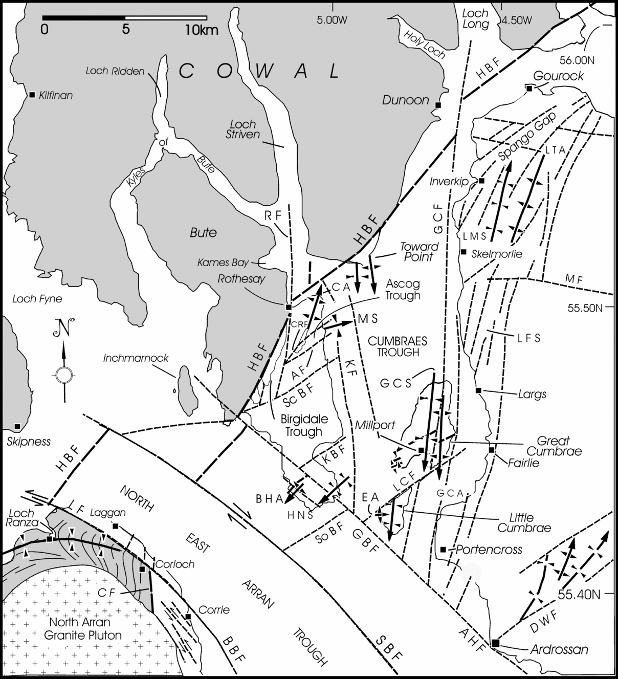
The North-East Arran Trough (Section 2.b.2 above) provides an analogue for what Young & Caldwell (Reference Young and Caldwell2012) identified as the Cumbraes Trough, which occupies most of the uppermost Firth (Fig. 8). Defined by the Great Cumbrae Fault to the E and, to the W, by the Kerrycroy Fault (named herein) and perhaps other major faults within the shipping channel of the upper Firth, the N–S Cumbraes Trough is taken to extend from the Ardrossan Harbour Fault to the HBF and to incorporate a number of small, subordinate basins. The Cumbrae islands, at the trough's southern end, display the most prominent of these with an anomalously thick succession of sedimentary and volcanic rocks (Fig. 2).
Uncertainty attaches to the submarine geology of the Cumbraes Trough (compare, for example, McLean & Deegan, Reference Deegan, McLean and Deegan1978, fig. 8.1 and British Geological Survey, 1985), particularly regarding the western boundary. Deegan (Reference Deegan, McLean and Deegan1978, p. 63) confirmed the presence of two main channels within the upper Firth (McLean & Deegan, Reference McLean, Deegan, McLean and Deegan1978, fig. 1.1). The eastern one coincides with northward prolongation of the Great Cumbrae Fault, but the western one – orientated c. N10°W, parallel to the E coast of mid-Bute, and lying a little more than 2 km offshore – is apparently without structural foundation, except for a short stretch S of Ascog in Bute, where a residual gravity anomaly points to the presence of a fracture now identified as the Kerrycroy Fault (McLean & Deegan, Reference McLean, Deegan, McLean and Deegan1978, fig. 8.1). Surficial deposits on the trough floor are thicker in both channels. A plot of total magnetic intensity exposes two, parallel, linear series of elongated anomalies, c. 2 km apart, aligned with the Bute coast (McLean & Walker, Reference McLean, Walker, McLean and Deegan1978, pp. 39–41, fig. 3.1). The eastern line can be traced from just S of Toward Point to midway between Kerrytonlia Point, on the northern side of Kilchattan Bay, south Bute, and Fintray Bay, Great Cumbrae (Figs 4, 8). There it ends abruptly against another anomaly of ENE orientation believed to mark the trace of the Kilchattan Bay Fault on route across the main shipping channel towards northern Great Cumbrae (Section 2.a.1 above). The western line can be traced from Toward Quay to the southern promontory of Bute where, about 1 km SE of Glencallum Bay, it meets the Ardrossan Harbour Fault. From this point, it merges with the magnetic anomaly located some 800 m off the S coast of the south Bute promontory, possibly created by faulted repetition of the igneous rocks that dominate that coast (Section 2.a.1 above).
McLean & Walker (Reference McLean, Walker, McLean and Deegan1978, p. 39) interpreted the linear magnetic anomalies along the E coast of mid-Bute as expressions of large dykes in pre-existing faults. The N–S orientation of these dykes is consistent with that of many major Palaeogene dykes S of the HBF in mid-Bute (Geological Survey of Great Britain, Scotland, 1948; British Geological Survey, 1985, 2008), southern Cowal (Anderson, Reference Anderson1951, fig. 15), and eastern Arran (Tyrrell, Reference Tyrrell1928, pp. 241–7, fig. 34; Richey, Reference Richey1939, p. 420, fig. 6; British Geological Survey, 1987). The western margin of the Cumbraes Trough is regarded, therefore, as defined by a largely dyke-filled Kerrycroy Fault (McLean & Deegan, Reference McLean, Deegan, McLean and Deegan1978, fig. 8.1), a fracture analogous to the Brodick Bay–Laggan Fault in the North-East Arran Trough on the western side of south Bute (Figs 1, 8).
Thus, although the boundary faults of the North-East Arran Trough and the Cumbraes Trough belong to differently orientated fault groups, they behaved similarly, their offshore sides undergoing relatively high rates of subsidence as Carboniferous sediments were deposited. To a considerable extent, the troughs complement and supplement one another in terms of their post-Devonian, Palaeozoic sedimentary records. The Cumbraes Trough apparently lacks rocks younger than the Early Carboniferous (Viséan) lavas of the Clyde Plateau Formation, whereas the North-East Arran Trough includes c. 1 km of Carboniferous sedimentary rocks above the top of these lavas, together with a further c. 0.5 km of New Red (mostly Permian) Sandstone. Both troughs display a marked reduction in thickness of the Lower Carboniferous sedimentary rocks below the Clyde Plateau lavas in their marginal zones and across their boundary faults (see Hall, Reference Hall, McLean and Deegan1978, p. 48; McLean & Wren, Reference McLean, Wren, McLean and Deegan1978, p. 19; McLean & Deegan, Reference McLean, Deegan, McLean and Deegan1978, p. 108, fig. 8.1; and Young & Caldwell, Reference Young and Caldwell2012 for details of the Brodick Bay – Laggan Fault). At the S end of the Cumbraes Trough, the Cumbraes Basin carries perhaps the thickest Inverclyde section of the upper Firth (Fig. 2).
Although not strictly part of the Cumbraes Trough, the most westerly member of the N-trending fault group in the upper Firth is that extending from the southern reaches of Loch Striven to define the E coast of Bute between Kames Bay and Rothesay Bay and entering mid-Bute at Rothesay. This fault, herein designated the Rothesay Fault, effects sinistral displacement of the HBF on the S side of Rothesay Bay, recalling similar movements on the Great Cumbrae Fault just S of the entrance to Loch Long, some 12 km to the NE (Figs 1, 8).
2.c.3. Origin and age span
The origin of the Great Cumbrae Fault and associated fractures in the Largs system is less than certain, but the available evidence points to them having been initiated in Early Devonian times or even earlier as splays off the HBF system, then reactivated and further multiplied. Monro (Reference Monro1999, p. 109) suggested that association of the Largs–Hunterston faults with the kind of detritus found in the wedge of Portencross Formation at the S end of the Hunterston promontory may indicate the faults’ existence by Early Devonian time. To this may now be added four other disparate lines of direct and circumstantial evidence for Late Devonian and subsequent reactivations that include kilometre-scale displacements of Carboniferous and Palaeogene rocks by the Great Cumbrae Fault.
(1) Relation to the HBF. Two possible connections to the HBF system have already been advanced. Paterson, Hall & Stephenson (Reference Stephenson, Paterson, Hall and Stephenson1990, pp. 36–7, fig. 1; see also Anderson, Reference Anderson1951, pp. 104–5; Patterson, Reference Patterson1952, p. 435) drew attention to a series of faults, trending close to the orientation of the Great Cumbrae Fault, that combine sinistral strike-slip and vertical displacements and may be related to the HBF system. These faults displace the axial zone of the Aberfoyle Anticline (leading edge of the Tay Nappe) in the Dalradian rocks immediately N of the highland line, where the axial zone strikes across the Roseneath peninsula and Loch Long towards Cowal and Bute (British Geological Survey, 1990). One such fault – the Rothesay Fault – has already been discussed (Section 2.c.2 above; Figs 1, 8).
Another link of the Great Cumbrae – Largs system to the HBF system is suggested by the manner in which some Largs–Hunterston faults veer increasingly northeastwards to run subparallel to, or ultimately merge with, components of the HBF (Patterson, Reference Patterson1952, fold-out map; McLean & Deegan, Reference McLean, Deegan, McLean and Deegan1978, fig. 8.1; British Geological Survey, 1985; Fig. 8). Paterson, Hall & Stephenson (Reference Paterson, Hall and Stephenson1990, pp. 36–7, figs 1, 8) and Monro (Reference Monro1999, p. 109) saw them as ‘splays’ off the latter – an interpretation still further bolstered by the manner in which the N-trending faults continue through the Spango Gap to Greenock and thence across the Clyde estuary into the HBF zone SW of Loch Lomond (British Geological Survey, 1990; Fig. 8).
(2) Reactivation history. The reactivation history of the Great Cumbrae Fault – minimally Early Carboniferous to Early Palaeogene (Caldwell & Young, Reference Caldwell and Young2012) but more probably pre-Carboniferous to Early Palaeogene – shows that it and other members of its group are old established structures. This particular fault also provides the clearest record of strike-slip displacement and thus provides a standard against which to assess the movements of other faults in the group. The Great Cumbrae Fault underwent strike-slip displacement after the Craignan Fitheach Fault was initiated and after the Early Carboniferous (Viséan) dyke swarm was emplaced in later Holkerian time (Fig. 4). The latter fault, one of the lesser NE–SW faults in the upper Firth, probably originated shortly after the terminal phase of Caledonian earth movements. Thus, although individual members of the Clyde Plateau dyke swarm cannot be reliably matched across the Great Cumbrae Fault, displacement of the Great Cumbrae Trachyte Belt can be shown essentially to match that of the Craignan Fitheach Fault, and restoration to their original positions brings about a more-focused alignment of all major ‘trachytic’ intrusions with their inferred magmatic source: the Misty Law Trachytic Centre of the Renfrewshire Hills (Caldwell & Young, Reference Caldwell and Young2012, figs 3, 12).
The Great Cumbrae Fault moved again after the quartz-dolerite dykes were intruded during the Silesian (Westphalian D) ‘tholeiitic event’ (Caldwell & Young, Reference Caldwell and Young2012, tables 1, 5; Fig. 4), possibly as a late adjustment to the extensional forces that led to emplacement of that dyke swarm. The final, recorded, major transcurrent movement on the fault was in mid- to later Palaeogene or post-Palaeogene times, following emplacement of the dykes of feldspar-macrophyric hyaloandesite that Tyrrell (Reference Tyrrell1917, Reference Tyrrell1918) called ‘cumbraite’, when the fault's movement may have been a far-field response to rifting, crustal stretching and dyke emplacement in the Hebridean Igneous Province of the North Atlantic Superprovince (Emeleus & Gyopari, Reference Emeleus and Gyopari1992; Saunders et al. Reference Saunders, Fitton, Kerr, Norry, Kent, Mahoney and Coffin1997; Bell & Williamson, Reference Bell, Williamson and Trewin2002; Emeleus & Bell, Reference Emeleus and Bell2005; Macdonald & Fettes, Reference Macdonald and Fettes2007). These conspicuous displacements, manifest on a kilometre scale, may still record only part of the fault's history: they do not preclude movements of the same or lesser magnitudes that failed to imprint themselves on the surviving geological record.
(3) Marginal growth faults of the Cumbraes Basin. The Great Cumbrae Fault delineates the eastern edge of the small sedimentary basin that is a distinctive component of the larger Cumbraes Trough (Fig. 8). This basin contains an unusually thick succession of Dinantian rocks belonging mainly to the Tournaisian Inverclyde Group (Fig. 2). The succession is not found E of the fault and is not comparably developed elsewhere in the upper Firth, which suggests that the fault served as a growth margin to the basin. Other faults in the northerly trending group, including those beneath Fairlie Roads and the Largs Channel, may have shared this role, building a stepped eastern margin from the basin axis to the Largs–Hunterston shoulder (Fig. 1). Other pointers to the character of the eastern margin derive from local details but, unfortunately, tend to be moot. For example, if the Great Cumbrae Fault were the key or only controlling structure, lithofacies changes might be anticipated in the Clyde Sandstone Formation, which is exposed near the fault plane on the western side of Kames Bay (Fig. 4). No particular changes are evident. Elsewhere on Great Cumbrae, however, the Clyde Sandstone Formation contains olistostromal pockets which could well have been generated by tectonic movement on a local fault, in keeping with the interpretation of some syndepositional structures in sandstones of the Stratheden Group of the mainland (see below).
(4) Related faults and facies control. Other N-trending faults exerted some control on lithofacies and spatial distribution in the largely Famennian sandstones of the Stratheden Group in the coastal belt of the adjacent mainland. Differences across the Largs–Hunterston faults between Largs and West Kilbride allowed Bluck (Reference Bluck, Reading and Balance1980) and Monro (Reference Monro1999) to differentiate the successions nominally on the eastern and western sides of these structures. In addition, Monro (Reference Monro1999, p. 16) found the Kelly Burn Sandstone on Great Cumbrae to be ‘very much thicker’ than that at Hunterston on the mainland, and McLean & Walker (Reference McLean, Walker, McLean and Deegan1978, p. 37) noted that it increased in thickness by about one-third between the W side of the Hunterston promontory and the E side of Great Cumbrae. Monro also noted that, adjacent to the Largs–Hunterston faults, the Kelly Burn Sandstone in its Seamill facies carries syndepositional slump structures recording local tectonic instability.
The Great Cumbrae Fault and associated members of the Largs–Hunterston system, are interpreted, therefore, as ‘old’ structures dating at minimum to the earliest expressions of Variscan deformation that followed termination of the Caledonian Orogeny in the Late Devonian Epoch, about 370 million years ago, and probably to considerably earlier than that (Paterson, Hall & Stephenson, Reference Paterson, Hall and Stephenson1990, p. 37; Monro, Reference Monro1999, p. 109; Macdonald & Fettes, Reference Macdonald and Fettes2007, p. 260).
3. Structures of the Upper Firth of Clyde II: folds
Upper Palaeozoic rocks of the Firth have been deformed by at least two sets of open plunging folds, one with axial trace close to N–S, the other close to E15°N (but for general contradistinction called simply E–W). They have been found most commonly in the upper part of the Firth (Fig. 8), including parts of the mainland (Paterson, Hall & Stephenson, Reference Paterson, Hall and Stephenson1990; Monro, Reference Monro1999; British Geological Survey, 1990, 2006). The folds have an irregular and scattered distribution and, compared to the faults, exert less control on outcrop distribution and show fewer signs of having any persistent geomorphological expression. Given that both E–W and N–S folds are present on Great Cumbrae, the island makes a suitable locality to initiate consideration of the folds.
3.a. Folds of the Cumbrae Islands
N–S folds dominate the structure of Great Cumbrae. West of the Great Cumbrae Fault (Section 2.c.1 above), the island is occupied by the gently southward-plunging Great Cumbrae Syncline (Figs 4, 8). To the E, the fault-truncated western limb of the complementary, tighter, southward-plunging Great Cumbrae Anticline is juxtaposed against the syncline. The basic synclinal structure of western Great Cumbrae is evident in the truncated arc of the Inverclyde Group, which defines the bight of Millport Bay.
Minor, open folds of similar axial orientation to the Great Cumbrae Syncline are superimposed upon it. The nose of a subordinate S-plunging anticline is exposed in shoreline outcrops of the Clyde Sandstone, 150 m E of Millport harbour, and a small S-plunging syncline is evident in similar rocks between the Leck and Long Point, on the W side of Kames Bay (Fig. 4).
The Inverclyde rocks carry evidence of strong, intermittent, syndepositional subsidence of the western tract of Great Cumbrae, which retains one of the best-exposed, most continuous and thickest sections (>500 m) of the Inverclyde Group up to the Millport Sandstone Member of the Clyde Sandstone Formation (Fig. 2) in the entire Firth. Apart from the Clach, all the islets in Millport Bay are composed of the succeeding, S-dipping Eileans Sandstone Member of that same formation, which may attain a considerably greater thickness than the 150 m estimated by Monro (Reference Monro1999) before being succeeded offshore by the Clyde Plateau Formation of the Strathclyde Group in the form of the Little Cumbrae lavas.
Little Cumbrae lies well to the W of the axial trace of the Great Cumbrae Syncline (Fig. 8), but the lava flows of Little Cumbrae are themselves folded into an asymmetrical syncline with weak southerly plunge (Gunn, Reference Gunn, Gunn, Geikie, Peach and Harker1903, fig. 2). The eastern limb is the more gently dipping, exposing the entire sequence of flows, the western limb prominently cross-folded in an eastward-plunging anticline, the axial trace of which is basically orthogonal to that of the syncline, close to which it seems to terminate. Cumbrae Elbow (Geikie, Reference Geikie1897, fig. 107; Figs 3, 9) offers the most obvious expression of an E–W fold in the upper Firth. The trend of the axis of the Little Cumbrae Syncline, broadly coincident with the long dimensions of the two outliers formed by the highest lava flows (Fig. 3), is basically co-aligned with that of the Great Cumbrae Syncline, which raises the question of their being either disconnected parts of one and the same fold, or parallel folds separated presumably by a narrow anticline or a fault. The anticlinal interpretation is untenable: no evidence of such a fold exists in southwestern Great Cumbrae, nor is there adequate space to accommodate one between the adjacent extremities of the islands. Moreover, the attitude of the layering of the rocks at these extremities is quite different (Figs 3, 4, 8). If the synclinal axes were previously co-aligned, however, their current westward displacement may be readily explained by dextral movement on an extended NE–SW Little Cumbrae Fault (Section 2.a.1 above; Figs 1, 8) through the outer reaches of Millport Bay into Fairlie Roads, where it may terminate against a fault of the Largs–Hunterston system. This interpretation, adopted herein, explains the current relative positions of the two islands and the anomalous position of the Little Cumbrae volcanic outlier in the middle of the upper Firth.
McLean & Deegan (Reference Deegan, McLean and Deegan1978, fig. 8.1) and the British Geological Survey (1985) envisaged the southward-dipping Carboniferous rocks around Millport Bay, W of the Great Cumbrae Fault (Fig. 4), to flare southward and extend to the NW-trending Glencallum Bay extension of the Ardrossan Harbour Fault (Fig. 8). The Clyde Plateau lavas forming Little Cumbrae were included but depicted as an unfaulted outlier within them.
3.b. Other folds
Other folds of variable size, scattered throughout the coastal mainland and offshore islands of the Firth, may be assigned to the broadly defined N–S and E–W sets.
3.b.1. The North Ayrshire and Inverclyde mainland
Two discrete sets of folds involving Upper Devonian and Carboniferous rocks have been reported from the coastal mainland of the upper Firth.
First, Paterson, Hall & Stephenson (Reference Stephenson, Paterson, Hall and Stephenson1990, pp. 36–8, fig. 1) identified the Leap Moor Syncline, Loch Thom Anticline and adjacent folds in the Inverclyde–North Ayrshire district, NE of Skelmorlie – open folds that, in axial orientation and scale, are like the folds of the Cumbraes and similarly involve rocks of the Stratheden and Inverclyde groups (Fig. 8). As these workers have pointed out, formation of the folds may have been influenced by certain NE- and N-trending faults of the HBF and Largs–Hunterston systems.
Second, Monro (Reference Monro1999, p. 111, fig. 29) distinguished a group of open folds associated with the major caledonoid Dusk Water Fault, NE of Ardrossan (Fig. 8). Slightly smaller in scale than the Cumbrae and Skelmorlie folds, they also show more variation in axial orientation, some trending N30°E. A small, plunging fold couplet at Ardrossan has a northeasterly inclination.
3.b.2. The Cumbraes Trough
Apart from the Cumbraes Basin, there may be other small sedimentary basins within the Cumbraes Trough. One such structure may lie between the northern end of Great Cumbrae and Toward Point, where geophysical surveys revealed a patch of layered Carboniferous rocks resting on Upper Old Red Sandstone and cut by a NNW-trending dyke presumably of Palaeogene age (McLean & Walker, Reference McLean, Walker, McLean and Deegan1978, pp. 35–6, fig. 3.3; McLean & Deegan, Reference McLean, Deegan, McLean and Deegan1978, fig. 8.1). Defined by a gravity anomaly, it is probably an erosional outlier of Inverclyde sedimentary rocks, possibly with a cap of Clyde Plateau lavas, but without additional data or samples, the stratigraphical assignment remains speculative. This outlier is not shown on the British Geological Survey's (1985) map of the Firth of Clyde.
The Old Red Sandstone and Carboniferous rocks of the Toward Point outlier at the S end of the Cowal Peninsula (Stark, Reference Stark1927) expose some of the most northerly folds in the Cumbraes Trough (Fig. 10). Within the outlier, the principal faults trend NE in conformity with the HBF, which defines the outlier's northern boundary, and a thin sequence of the Inverclyde Group is most completely preserved between two of them.
Similar offshore components of the HBF system or extensions of the faults that define the Ascog Block in mid-Bute may also have contributed to preserving Carboniferous rocks within the Cumbraes Trough as far N as Toward Point (McLean & Deegan, Reference McLean, Deegan, McLean and Deegan1978, fig. 8.1; Paterson, Hall & Stephenson, Reference Paterson, Hall and Stephenson1990, fig. 8; Fig. 8). Several small, open, complementary, southward-plunging, anticlinal and synclinal warps project offshore within an E–W distance of c. 2 km. The folds are much smaller than the Leap Moor and Loch Thom folds on the opposite side of the upper Firth or the primary folds of the Cumbraes, and their lateral extent beyond Toward Point is unknown. They may be locally developed and attributable to compression generated by transcurrent movement on the HBF.
3.b.3. Bute
A member of both the N–S and the E–W fold-sets is present on the E coast of the Isle of Bute, between Rothesay Bay and Kilchattan Bay, although neither is exposed to its full extent (Figs 7, 8).
Geological map of the coast of northeastern mid-Bute, from Rothesay Bay to Ascog Bay, to show the truncated, plunging nose of the Craigmore Anticline around Bogany Point and the complexity of the coastal geology of the Ascog Block between the Craigmore and Ascog faults. Note that this is one of a few localities where argillaceous beds – the Birgidale Formation – are exposed beneath the Clyde Plateau lavas (cf. Fig. 2).

Sketch map depicting the principal geological structures in the upper Firth of Clyde described in the paper. Abbreviations: Faults: AF – Ascog Fault; AHF – Ardrossan Harbour Fault (extended as GBF); BBF – Brodick Bay Fault (extended as Laggan Fault); CF – Corloch Fault (extension of HBF); CRF – Craigmore Fault; DWF – Dusk Water Fault; GBF – Glencallum Bay Fault (extension of AHF); GCF – Great Cumbrae Fault; HBF – Highland Boundary Fault (represented by a system of fractures on the N side of the upper Firth of Clyde. For details, see Qureshi, Reference Qureshi1970; McLean & Deegan, Reference McLean, Deegan, McLean and Deegan1978; British Geological Survey, 1990); KBF – Kilchattan Bay Fault; KF – Kerrycroy Fault; LF – Laggan Fault (extension of BBF); LCF – Little Cumbrae Fault; LFS – Largs Fault System (Largs–Hunterston Fault system of some pre-existing literature); MF – Muirshiel Fault; RF – Rothesay Fault; SBF – Sound of Bute Fault; ScBF – Scalpsie Bay Fault; SoBF – South Bute Fault. Other small faults are depicted in detailed maps of individual localities (see Figs 3, 4, 5, 7 & 10). Folds: BHA – Boat House Anticline; CA – Craigmore Anticline; EA – Elbow Anticline (Little Cumbrae); GCA – Great Cumbrae Anticline; GCS – Great Cumbrae Syncline; HNS – Hawk's Neb Syncline; LMS – Leap Moor Syncline; LTA – Loch Thom Anticline; MS – Montford Syncline. Complementary folds on the N side of the Dusk Water Fault and at Toward Point are neither all shown nor individually named (for details, see British Geological Survey, 2006; Fig. 10).

First, the Craigmore Anticline (Hill & Buist, Reference Hill and Buist1994, pp. 46–50, fig. 8; Reference Hill and Buist2006, pp. 44–8, fig. 10), with axial trace close to N20°E, is centred on Bogany Point and Canada Hill, 1.5 km E of Rothesay. The fold is truncated by northeasterly trending faults of the Ascog Block. Second, in the structurally complex shoreline exposures of the Ascog Block, Young & Caldwell (Reference Young and Caldwell2011c , pp. 151–2) described a small, partly fault-bound, E-plunging syncline containing rocks belonging to the upper part of the Clyde Sandstone (Ascog Member) and possibly the basal part of the Birgidale Formation, the latter overlying the Clyde Sandstone and known elsewhere to conformably underlie the Clyde Plateau Formation. The scale of the fold is unknown because of faulting and limited exposure (see Young & Caldwell, Reference Young and Caldwell2011c ).
Although the geology and geomorphology of south Bute are so thoroughly dominated by faults of the NE- and NW-trending groups (Sections 2.a.1 and 2.b.1 above; Fig. 5), remapping has revealed the presence of two open folds with gentle westerly plunge – the Boat House Anticline and the Hawk's Neb Syncline – referred rather arbitrarily to the E–W fold-set on the basis of their northeasterly axial traces (Figs 5, 8). The Hawk's Neb Syncline includes rocks as young as Clyde Plateau volcanic products correlative with the Misty Law Trachytic Member of the Renfrewshire Hills Block (Caldwell & Young, Reference Caldwell and Young2011, fig. 10; Young & Caldwell, Reference Young and Caldwell2011b , pp. 599–606, figs 2, 7).
3.b.4. Arran and beyond
In the first detailed description of the Carboniferous rocks of the Isle of Arran, Gunn (Reference Gunn, Gunn, Geikie, Peach and Harker1903, pp. 37–52) went to considerable lengths to contrast the section on the NE coast at Corrie and that further N between the Fallen Rocks at Corloch and Laggan (see British Geological Survey, 1987 and Fig. 8 for locations). In addition to marked differences in the stratigraphy, he pointed to structural differences: the Corloch–Laggan section, which dips to the NW, more disrupted by faults than the thinner section at Corrie, which is inclined to the SE and apparently more structurally intact. The sections seemed to lie on opposing limbs of a large, northeastward-plunging anticline. Gunn, however, may not have appreciated the contrasted facies of the two sections, the full effect of the small faults or the distortion brought about by subsequent emplacement of the North Arran Granite Pluton (Woodcock & Underhill, Reference Woodcock and Underhill1987; England, Reference England1992). Young & Caldwell (Reference Young and Caldwell2012) showed also that structural comparison of these sections must take into account their lying on opposite sides of the NW-trending Brodick Bay–Laggan Fault: the key line of structural separation between the syndepositional North-East Arran Trough (McLean & Deegan, Reference McLean, Deegan, McLean and Deegan1978, pp.108–9), in which the much thicker Corloch–Laggan sediments accumulated, and the flanking Corrie shoulder (Young & Caldwell, Reference Young and Caldwell2012, figs 1–5).
In the Kintyre Peninsula of the outer Firth of Clyde, Devonian and Carboniferous rocks are downthrown to the S against Dalradian metamorphic rocks by the NW-trending Kilchenzie Fault and are exposed in sizeable tracts of the Laggan of Kintyre from Machrihanish to Campbeltown (McCallien, Reference McCallien1927; McCallien & Anderson, Reference McCallien and Anderson1930; British Geological Survey, 1996b ). Some of the largest E–W folds in the entire Firth are developed between the Laggan and the southern extremity of the peninsula, near Southend (Fig. 11). The extent to which these folds and those of the upper Firth should be compared in detail, however, is questionable. They are widely separated geographically, fall into discrete geological terranes (Grampian and Midland Valley, respectively) and contain sedimentary and volcanic successions that in a number of respects are different from those of the upper Firth and closer to those around Ballycastle in Antrim (McCallien, Reference McCallien1927; McCallien & Anderson, Reference McCallien and Anderson1930; Wilson & Robbie, Reference Wilson and Robbie1966; Smedley, Reference Smedley1986, Reference Smedley1988). Southern Kintyre may have been subject to a discrete, stronger pulse of northward compression, producing not only the E–W folds but localized, small-scale thrusting of the Lower Carboniferous lavas (Clyde Plateau Formation equivalents), as at the Galdrings, on the W side of the peninsula, S of Machrihanish (McCallien, Reference McCallien1927, p. 96).
3.c. Ages of the folds
3.c.1. The Great Cumbrae Syncline and other N–S folds: site implications
Examination of the N–S folds reveals that deformation occurred in discrete phases, none of which can be dated with much precision, and more than one deformational mechanism may have been involved.
The youngest preserved lava flow of the Lower Strathgryfe Member of the Clyde Plateau Formation on Little Cumbrae establishes a maximum, relative age for the N–S folds of the Cumbraes, and Monaghan & Parrish (Reference Monaghan and Parrish2006) assigned that member a Dinantian (Viséan, middle to late Holkerian) relative age and a radiometric age of 335 ± 2 Ma in terms of the B time-scale of Menning et al. (Reference Menning, Weyer, Drozdzewski, Vanameron and Wendt2000).
Most similar in orientation and scale to the Cumbrae folds, the Leap Moor–Loch Thom folds, near Skelmorlie (Fig. 8), were related by Paterson, Hall & Stephenson (Reference Stephenson, Paterson, Hall and Stephenson1990, pp. 36–8) to Chadian–Holkerian uplift that preceded outpouring of the Clyde Plateau lavas and having their crests overstepped by lavas of the Upper Strathgryfe Member. The Cumbrae folds must be younger, therefore, because the Lower Strathgryfe Lavas, which they incorporate, lie well above the base of the Clyde Plateau Formation (Stephenson, Reference Stephenson, Paterson, Hall and Stephenson1990, pp. 19–26; Caldwell & Young, Reference Caldwell and Young2011; Section 3.a above). The Leap Moor–Loch Thom folds may then be middle Chadian – early Holkerian in age, the Cumbrae folds no older than middle to late Holkerian and possibly much younger.
It is also unlikely that the other folds of the North Ayrshire coastal tract (Monro, Reference Monro1999) have a common origin with those of the Cumbraes. The mainland folds are associated with the Dusk Water Fault, which underwent repeated reactivation in Carboniferous times (Section 2.a and 2.a.2 above), and they incorporate rocks as young as late Namurian and early Westphalian in the adjoining Dalry Basin (Monro, Reference Monro1985). Attributing the folds to transcurrent (or ‘reversed’) movement on the Dusk Water Fault Monro (Reference Monro1999, p. 111, fig. 29) finds support in a comparable parallelism of local fold-axes to the faults extending the Paisley Ruck immediately to the NE of the Dusk Water Fault (British Geological Survey, 2006). Monro's explanation, which implies a Late Carboniferous (at oldest) deformation, cannot be applied to the Cumbrae folds. The two groups of folds are separated by the southern end of the Great Cumbrae–Largs fault system and, despite being much further removed from the Dusk Water Fault, the Cumbrae folds are considerably more prominent (Fig. 8).
The ages of folds at localities N and W of the Cumbraes are also difficult to assess. At Toward Point (Section 3.b.2 above; Fig. 10), rocks as young as the lower Clyde Sandstone (Chadian) are deformed, and still younger rocks could be incorporated offshore. The character of the Toward structures is distinctive and, like Monro's (Reference Monro1999) folds adjacent to the Dusk Water Fault, they could have been generated by strike-slip on a major NE-trending fault – in the case of Toward, the Roseneath branch of the HBF system.
Finally, the Craigmore Anticline at Bogany Point in Bute (Section 3.b.3 above; Figs 7, 8), can be said only to post-date the Upper Old Red Sandstone Bute Conglomerate (Paterson & Hall, Reference Paterson and Hall1986, p. 9, figs 1, 3; Browne, Smith & Aitken, Reference Browne, Smith and Aitken2002, p. 47, fig. 8).
Thus, with the exception of the folds on the N side of the Dusk Water Fault, the N–S fold-set of the upper Firth involves only rocks of Late Devonian and Early Carboniferous (Dinantian) age, with the Lower Strathgryfe Lavas of the Clyde Plateau Formation (Viséan, Holkerian) the youngest involved. The N–S folds of the Cumbraes and other localities in the upper Firth are cut by E–W quartz-dolerite dykes of Westphalian D age (Monaghan & Parrish, Reference Monaghan and Parrish2006), which fail to show any effects of the folding. This suggests that the deformation is no younger than Carboniferous, although a cross-cutting relationship of this kind must be considered a somewhat equivocal guide to relative chronology insofar as, had the dykes been intruded prior to the folding, their attitude may have precluded their being noticeably deformed.
3.c.2. The Little Cumbrae Anticline and other E–W folds: site implications
The age of the E–W fold-set is also difficult to constrain, but these folds post-date the more prominent N–S structures. Arching of the western limb of the main syncline on Little Cumbrae involves the entire volcanic succession there (Figs 3, 9), which is probably Viséan (middle to late Holkerian) in age (Sections 3.a and 3.c.1 above). The same episode of E–W folding may well have been responsible for the small folds in the mid-Courceyan Foul Port Member of the Kinneswood Formation near Portachur Point on Great Cumbrae (Figs 2, 4).
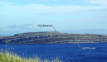
Lava flows belonging to the Lower Strathgryfe Member of the Clyde Plateau Formation at Cumbrae Elbow, Little Cumbrae, to show the anticlinal cross-fold superimposed on the western limb of the syncline that provides the principal structural control on the island (see Fig. 8 for location: view looking E from south Bute).

The Boat House Anticline and the Hawk's Neb Syncline of south Bute (Section 3.b.3 above; Fig. 5) call for a somewhat younger maximum age because they involve trachytic lavas believed to be correlative with the Misty Law Trachytic Member of the Clyde Plateau Formation in the Renfrewshire Hills, which separates the Lower and Upper Strathgryfe members (Stephenson, Reference Stephenson, Paterson, Hall and Stephenson1990, pp. 23–5). The folding in south Bute may post-date the remaining volcanic rocks there held to correlate to part of the Upper Strathgryfe lavas of the Renfrewshire Hills, but this cannot be demonstrated unequivocally in the field (Caldwell & Young, Reference Caldwell and Young2011, fig. 10; Young & Caldwell, Reference Young and Caldwell2011b , figs 2, 7).
In Kintyre, the Mull Anticline and Southend Syncline deform Old Red Sandstone and Carboniferous rocks including lavas similar to those of the Clyde Plateau Formation (Fig. 11). But differences between these lavas and those of the mainland plateau preclude stratigraphical correlation to the Renfrewshire Hills standard succession, and it is not known whether the deformed lavas of the Southend Syncline are younger or older than those of Little Cumbrae and south Bute.
Geological map of the Toward Point shore section on the Cowal Peninsula to expose the stratigraphical succession and the unusual character of the N–S folds.

Geological sketch map of the southern portion of the Kintyre Peninsula to illustrate the prominent E–W folds in the Upper Palaeozoic rocks between the Laggan and the S coast.

In summary, none of the E–W folds is known to be older than Viséan (middle to late Holkerian). They could be much younger, their age-range having no known upper limit, and they could be products of one or more compressional episodes. The simplest interpretation based on field relationships would attribute them to a single deformational episode probably no older than middle Namurian (Arnsbergian).
4. Synthesis: structures of the upper Firth in regional tectonic context
Over the last 30 years, post-Caledonian–Variscan tectonic history in the MVS has been reviewed in several papers, some broadly regional, others with a bias towards a chosen area and focus, and most present interpretations that conflict to some degree. Recent examples include Read et al. (Reference Read, Browne, Stephenson, Upton and Trewin2002), Browne et al. (Reference Browne, Monaghan, Ritchie, Underhill, Hooper, Smith and Akhurst2003), Goodenough, Stephenson & Loughlin (Reference Goodenough, Stephenson, Loughlin, Stephenson, Loughlin, Millward, Waters and Williamson2003), Ritchie et al. (Reference Ritchie, Johnson, Browne and Monaghan2003), Upton et al. (Reference Upton, Stephenson, Smedley, Wallis, Fitton, Wilson, Neumann, Davies, Timmerman, Heeremans and Larsen2004), Monaghan & Parrish (Reference Monaghan and Parrish2006), Macdonald & Fettes (Reference Macdonald and Fettes2007), Waters et al. (Reference Waters, Browne, Dean and Powell2007) and Underhill, Monaghan & Browne (Reference Underhill, Monaghan and Browne2008), and these have been relied upon herein, individually and collectively, as a primary source of regional tectonic history. Conflicting interpretations are rooted mainly in the changing stress fields that impacted on the MVS, producing what Macdonald & Fettes (Reference Macdonald and Fettes2007, p. 20) described as ‘structures of various styles and orientations [implying] . . . a complex polyphase tectonic history of extension, transtension, transpression and inversion’. By reviewing tectonic style and magmatism in northern Europe during the same period, Timmerman et al. (Reference Timmerman, Heeremans, Kirstein, Larsen, Spencer-Dunworth and Sundvoll2009) allowed the MVS to be considered in a wider regional context, and among existing regional tectonic models, the version by Coward (Reference Coward and Parker1993) best accommodates the findings of this study (Fig. 12).
Schematic diagrams combining elements of the extrusion tectonics model of Coward (Reference Coward and Parker1993) with the back-arc basin proposed by Leeder (Reference Leeder1982) to illustrate the possible tectonic configuration of Europe during the evolution of the Midland Valley of Scotland (MVS) in Late Devonian–Carboniferous times. Black arrows show plate movements; light arrows show proposed movement of the Northern European Block (NEB) during Dinantian times. (a) The northern MVS is dominated by sinistral strike-slip faulting as the NEB is displaced to the NE. At the same time, subduction during closure of the Proto-Tethys Ocean caused development of a continental back-arc basin in the vicinity of the MVS, with attendant widespread magmatic activity, including the Clyde Plateau volcanism. (b) Compression from the NE, related to closure of the Ural Ocean, caused dextral movement on NE-trending faults in the MVS (see strain ellipsoid). At the same time, the Uralide compression induced sinistral strike-slip on NW-trending faults, whereas continuing compressive forces from the S (dying phase of the Variscan Orogeny) tended to cause fault movements in the opposite sense. (c, d) Schematic N–S cross-sections through the UK showing the inferred tectonic setting of the MVS. When subduction ceased, thermal subsidence led to basin inversion with reverse movement on many former basin-defining normal faults. The large E–W-trending quartz-dolerite dykes of the MVS may be related to the putative Oslo plume (Burke & Dewey, Reference Burke and Dewey1973), whereas the dominantly northwesterly Palaeogene dyke swarms and Central Igneous Complexes (the dyke swarms extending from the western part of Scotland into England) are part of the regional magmatic episode associated with rise of the Icelandic Mantle Plume and opening of the NE Atlantic Ocean. Abbreviations: GGF – Great Glen Fault; HBF – Highland Boundary Fault; SUF – Southern Uplands Fault; KKC – Kazakhstano–Kirgizian continents. See text for discussion.

4.a. NE-trending faults
Movement on the NE-trending faults was dominated by sinistral strike-slip in the Late Devonian – Early Carboniferous and dextral strike-slip in the Late Carboniferous epochs, with the reversal occurring some time between late Viséan and early Namurian (Arnsbergian) time. When the faults were initiated, the MVS was under an extensional regime related to Dinantian northward subduction (Fig. 12a, c). This is also manifest in the outbreak of magmatism, which began earlier in the Cumbraes than in most other parts of the MVS (Young & Caldwell, Reference Young and Caldwell2011a ), and gave rise later to the dense dyke swarm and lavas of the Clyde Plateau (Caldwell & Young, Reference Caldwell and Young2011, Reference Caldwell and Young2012; Young & Caldwell, Reference Young and Caldwell2011b ,c). But the MVS must also have experienced far-field northward-directed transpressional stresses stemming from closure of the Rheic Ocean in Devonian time and the Proto-Tethyan Ocean in Early Carboniferous time (Leeder, Reference Leeder1988).
The NE-trending faults of the upper Firth (Section 2.a above) are readily accommodated to this regional interpretation, but unfortunately lack clear evidence of the amount or direction of strike-slip displacement they are anticipated to have undergone (Fig. 12a, b, strain ellipsoids). Only the Dusk Water Fault (Section 2.a above) provides unequivocal evidence of repeated movement during the Late Carboniferous Epoch. As dextral strike-slip became established, thermal subsidence and basin inversion took place, together with intensifying transpression (Fig. 12b, d). Transcurrent movements on the faults probably played a primary role in the development of flanking folds on the N side of the Dusk Water Fault, near Ardrossan (Fig. 8), and the S side of the HBF at Toward Point, as they may also have influenced folding at other localities. The reversal of strike-slip displacement on these NE-trending faults from sinistral to dextral is in keeping with the change from Variscan to Uralian compression (Coward, Reference Coward and Parker1993; Puchkov, Reference Puchkov, Burg and Ford1997; Friburg et al. Reference Friburg, Juhlin, Beckholmen, Petrov and Green2002; Fig. 12).
4.b. NW-trending faults
The NW-trending faults in the upper Firth (Section 2.b above) are also readily reconciled with the tectonic conditions believed to have prevailed regionally in Carboniferous times. A graphical explanation of why these faults have strike- or oblique-slip components is shown by the strain ellipsoids in Figure 12, which also explain why some have dextral, others sinistral, displacements, and still others offer evidence of both.
4.c. N-trending faults
Concentrated in a narrow band from Loch Long along the coast of the Inverclyde–North Ayrshire mainland, through the Largs Channel and Fairlie Roads, to S of the Hunterston–Portencross promontory (Fig. 8), the mean orientation of the group is ~N15°E. From Skelmorlie N, this orientation swings through another 30° to the E as they become aligned, or confluent, with segments of the HBF system (British Geological Survey, 1990). Their inferred age of origin (no younger than Late Devonian; Section 2.c.3 above) may be related to the earliest post-Caledonian reactivation of the HBF system (Paterson, Hall & Stephenson, Reference Stephenson, Paterson, Hall and Stephenson1990). The change in strike of the faults and concentration in the Spango Gap may have influenced development of the geniculate bend in the Clyde estuary at the ‘Tail of the Bank’, just as the consistent N15°E course of the faults southwards from that point probably controlled the trend of the coastline. The confinement and prominence of this fault system may indicate a pre-existing, deep-seated zone of weakness.
Similar but larger fractures are present in the north-central and northeastern sectors of the MVS (Rippon, Read & Park, Reference Rippon, Read and Park1996; Ritchie et al. Reference Ritchie, Johnson, Browne and Monaghan2003; Monaghan & Parrish, Reference Monaghan and Parrish2006; Underhill et al. Reference Underhill, Monaghan and Browne2008). According to Haszeldine (Reference Haszeldine, Besly and Kelling1988) and Stedman (Reference Stedman, Besly and Kelling1988), these faults imply regional E–W extension. Read (Reference Read, Besly and Kelling1988), Rippon, Read & Park (Reference Rippon, Read and Park1996) and Richie et al. (Reference Ritchie, Johnson, Browne and Monaghan2003) attributed them to E–W tension in large tracts of the MVS, in response to strike- or oblique-slip movements on major caledonoid faults – an interpretation compatible with the Coward model (Fig. 12). Structural analogies are strengthened by the presence of at least one growth basin in the upper Firth of consistent axial orientation – the Cumbraes Basin – developed on the W side of the Great Cumbrae Fault. This basin is relatively small, however, and was actively subsiding in Dinantian time when sinistral strike-slip prevailed. The much larger basins of the north-central to northeastern MVS developed mainly in late Namurian to Westphalian D time when dextral strike-slip was dominant.
4.d. Folds
Discovery of the N–S folds in the upper Firth again invites comparison to the north-central and northeastern MVS, where elongate growth basins developed on faults of similar orientation. These larger basins (Rippon, Read & Park, Reference Rippon, Read and Park1996; Ritchie et al. Reference Ritchie, Johnson, Browne and Monaghan2003; Underhill et al. Reference Underhill, Monaghan and Browne2008) are attributed mainly to episodes of transtension and transpression in Late Carboniferous (Silesian) time when dextral strike-slip conditions prevailed. In contrast, the principal N–S folds of the upper Firth (Section 3.c.1 above) formed over a wider range of time, some much earlier, and some probably by quite different mechanisms. Thus E–W compression associated with a phase of uplift (or possibly volcanic doming) in about end-Tournaisian (Chadian) time has been held responsible for the Leap Moor–Loch Thom folds and their truncation prior to Viséan (Holkerian) time (Paterson, Hall & Stephenson, Reference Paterson, Hall and Stephenson1990, p. 37), and reactivation of the powerful Dusk Water Fault for originating the much younger folds involving Lower Coal Measures of Westphalian (Langsettian) age in the Dalry Basin, near Ardrossan (Section 3.b.1 above).
Among the N–S folds in the upper Firth (Sections 3.a and 3.b above), those of the Cumbrae islands offer the closest analogue of structures in the north-central and northeastern MVS, such as the Kincardine Basin (Rippon, Read & Park, Reference Rippon, Read and Park1996), in that they incorporate a growth basin related to development of a major N–S fault. The basins, however, are radically different in size, in the age span of the deposits they contain and in the time of principal sediment accumulation: the Cumbraes Basin carries sedimentary rocks of the Stratheden Group (almost certainly Famennian in age) and Inverclyde Group (Tournaisian, Courceyan–Chadian in age) and Clyde Plateau lavas of the Strathclyde Group (Viséan, Holkerian in age), whereas the large basins E of the Clyde Plateau contain mainly thicker accumulations of the Clackmannan and Scottish Coal Measures groups (Namurian–Westphalian in age). The smaller size of the Cumbrae folds may be explained by their being far-field structures formed behind the developing buttress of the Clyde Lava Plateau, which helped to dissipate episodic, westward-encroaching transpression and, by latest Viséan time, prevented it from affecting the northwestern offshore MVS. Like those of the north-central and northeastern MVS, the N–S folds of the Cumbraes were in place by latest Westphalian (D) times because they are transected by the thick quartz-dolerite dykes emplaced at that time (Monaghan & Parrish, Reference Monaghan and Parrish2006). As first suggested by Coward (Reference Coward and Parker1993), the N–S folds and the reversal in strike-slip movements on NE-trending faults may be related to plate-tectonic events in the distant Ural Mountains. Puchkov (Reference Puchkov, Burg and Ford1997) pointed out that Uralian orogenic activity was diachronous and long lived, beginning with the accretion of arcs and micro-continents to the East European passive margin (‘soft collision’) between Late Devonian (late Frasnian) and early Middle Carboniferous times. ‘Rigid collision’ between the East European and Kazakhstano–Kirgizian continents (Puchkov, Reference Puchkov, Burg and Ford1997, fig. 17), which began in Middle or Late Carboniferous times (Friburg et al. Reference Friburg, Juhlin, Beckholmen, Petrov and Green2002) and continued into Late Permian time, involved stacking of thrust sheets, large-scale folding and the production of anatectic granites. It is the latter phase that probably was responsible for far-field effects in the western part of the MVS.
Aspects of the structural evolution of the Bolshoi–Karatau region of southern Kazakhstan, described by Allen, Alsop & Zhemcheshnikov (Reference Allen, Alsop and Zhemcheshnikov2001), also warrant close scrutiny insofar as they offer striking analogues of changing transpressive stresses and reversal of strike-slip movements on associated faults. Although there are notable differences in the size of the Kazakhstan region and the western MVS and in the timing of the polyphase deformation (distinct reactivational episodes having been recognized in the former from Neoproterozoic to Cenozoic time), similarities exist, particularly in the two Late Palaeozoic phases that most strongly affected the Late Devonian and Carboniferous rocks. The Karatau Fault System involved sinistral movements, followed by dextral transpressional reactivation – the combination resulting in a proportionately scaled, dome-and-basin fold interference pattern. Such polyphase deformation is thought to have affected large parts of central Asia. Of further and greater potential relevance to the MVS, Allen, Alsop & Zhemcheshnikov (Reference Allen, Alsop and Zhemcheshnikov2001) pointed out that reversals in the sense of strike-slip-dominated transpressive deformation across major fault systems result in transpressive inversion – an ideal process by which overprinted, orthogonal fold systems may be produced.
None of the E–W folds in the upper Firth is known to be older than Viséan (middle to late Holkerian), and they could be much younger – products of one or more transpressional episodes. Whereas field relationships permit them to be grouped in a single deformational episode no older than middle Namurian (Arnsbergian) and possibly younger, the regional tectonic setting favours a somewhat younger origin (Westphalian, Bolsovian or older) as the far-field expression of compression or transpression linked to the culminating phase of Variscan deformation (Figs 12c, d) when the MVS was subject to basin inversion. No E–W fold, however, is known to be transected by a member of the quartz-dolerite dyke swarm, which is of Westphalian D age.
5. Conclusions
Analysis of faulting and folding in the area of the upper Firth allows the following conclusions to be drawn.
(1) Three groups of intersecting faults, orientated broadly NE, N and NW, have been persistent primary controls on the stratigraphical, structural and geomorphological evolution of the upper Firth of Clyde from the Late Devonian termination of the Caledonian Orogeny, some 370 million years ago.
(2) All three groups of faults were initiated or reactivated by proto-Variscan stresses applied to the western MVS when it was part of the Variscan foreland, and all three underwent numerous influential movements during the Caledonian–Variscan interval.
(3) In a regional tectonic regime dominated by sinistral faulting in Late Devonian – Early Carboniferous time, dextral in Late Carboniferous time, horizontal or oblique-slip movements were common in all three fault groups.
(4) Insofar as some NE-trending faults were initiated by rejuvenation of deep-seated Caledonian structures, this group is interpreted as the first to have appeared, but as some early NW-trending faults probably were initiated as conjugate fractures, this latter group is thought to have developed at about the same time – an inference supported by syndepositional evidence.
(5) If the NE-trending faults were the earliest group to develop, they were also the first to show signs of waning. By middle to late Viséan times, certain lesser faults had completed their important movements and begun to be increasingly overprinted by N- and NW-trending faults.
(6) Some members of each fault group exhibit characteristics in common with the others. Thus, for example, some members of the N-trending group moved in concert with NE-trending members of the HBF system that spawned them; some N- and NW-trending faults served as growth faults for small basins and troughs, such as the Cumbraes Basin and North-East Arran Trough respectively; and in their syndepositional effects, these faults behaved like major NE-trending faults such as the Dusk Water.
(7) Reactivation of all three groups of faults was rife and commonly masked or obliterated evidence of preceding movements. The NW-trending group underwent particularly strong reactivation during later (post-Viséan) Carboniferous time, giving a misleading impression that it was then that the group originated. At least the NW- and N-trending groups maintained intermittent movements through Early Palaeogene time.
(8) The off-setting of dykes belonging to swarms of Viséan, Westphalian and Paleocene–Eocene age by the N- and NW-trending faults provides a convenient basis for reconstructing strike-slip displacements, especially on Great Cumbrae. This in turn has contributed to refining the relative chronology of minor-intrusive emplacement in the upper Firth (Caldwell & Young, Reference Caldwell and Young2012).
(9) Upper Palaeozoic rocks of the Firth have been patchily deformed by two primary sets of open, plunging folds, one with axial traces broadly N–S, the other E–W. Folding may well have developed in association with strike-slip faulting, but this cannot be demonstrated conclusively. It is suggested by some folds adjacent to major NE-trending faults, such as the HBF and Dusk Water.
(10) With the exception of these localized folds probably generated by strike-slip movements on major NE-trending faults, the N–S folds of the upper Firth involve only rocks of Late Devonian and Early Carboniferous age, with Viséan (Holkerian) lavas the youngest. Some N–S folds are cut by E–W quartz-dolerite dykes and may, therefore, be no younger than Westphalian (Bolsovian). Folds developed at least twice within this Holkerian–Bolsovian interval. The N–S folds broadly resemble similarly orientated structures in the north-central and northeastern MVS, but the N–S structures E of the Clyde Lava Plateau developed in Namurian–Westphalian times are much larger, and formed in response to stresses from the NE in a dextral strike-slip environment rather than the earlier (Dinantian) sinistral setting. The smaller size and more limited stratigraphical range of the Cumbrae folds may be explained by their being far-field structures formed behind the massif of the Clyde Lava Plateau, which acted as a buttress against westward-encroaching transpression, possibly resulting from continental collision in the Uralian Orogeny.
(11) Both the N–S folds of the Cumbraes and those of the north-central and northeastern MVS were in place by latest Westphalian times because they are transected by E–W quartz-dolerite dykes. They could have formed at any time in the middle Viséan to Bolsovian interval, but regional tectonic considerations favour a Namurian (post-Arnsbergian) age.
(12) None of the E–W folds in the upper Firth is older than Viséan (middle to late Holkerian), and they could be much younger. The simplest interpretation would attribute them to a single deformational episode, probably no older than early Namurian (Arnsbergian) and possibly younger, whereas the known tectonic evolution of the region would favour a younger, Westphalian age and interpret them as far-field products of transpression generated in the culminating stages of the Variscan Orogeny. No E–W fold is known to be transected by the terminal Westphalian quartz-dolerite dyke swarm.
(13) As first suggested by Coward (Reference Coward and Parker1993), the N–S folds and the reversal of strike-slip movements on NE-trending faults may be related to plate-tectonic events in the distant Ural Mountains. Similar strike-slip reversals in the Karatau Fault System and associated fold generation in southern Kazakhstan may offer a contemporaneous, large-scale analogue for tectonic events affecting the MVS.
Acknowledgements
We are grateful to the late T. Neville George, Professor of Geology in the University of Glasgow, who first introduced us to the geology of the Firth of Clyde, and to many members of his department who assisted us over the years, prominent among them Dr Brian Bluck, who first recognized the Craignan Fitheach Fault on Great Cumbrae, and Mr David Boyd, who conducted a magnetometer survey across a tract of the Great Cumbrae Fault in search of trailing dykes. The late Dr J. S. McTavish and Provost D. McLachlan of Millport assisted with aspects of the early field work, as did Messrs S. McIntyre, F. and K. Mapes, and J. Macfarlane with later investigations of this kind. We have greatly benefitted from critical review of our work by Dr H. C. Morris of Vancouver and ensuing discussions with him. Our transatlantic investigations have been supported in part by grants from the Natural Sciences and Engineering Research Council of Canada. Figure 3, modified after Caldwell & Young (Reference Caldwell and Young2011), and Figure 4, modified after Caldwell & Young (Reference Caldwell and Young2012), are reproduced with permission of the Royal Society of Edinburgh. Figure 1, modified after Young & Caldwell (Reference Young and Caldwell2012), is reproduced with permission of Geological Magazine. Figure 5, modified after Young & Caldwell (Reference Young and Caldwell2011c ), is reproduced with permission of the Scottish Journal of Geology.