
Introduction
The earliest Neolithic settlements in Europe were founded around 6500 cal BC in Greece and north-western Turkey, and they seem to have their roots in Anatolia (Brami & Heyd Reference Brami and Heyd2011; Özdoğan Reference Özdoğan and Krauss2011). Traditional models describe the spread of Neolithic settlement out of Anatolia as being triggered by either migration or diffusion. Increasingly, such views are being replaced by inter-regional demic diffusion models (Ammermann & Cavalli-Sforza Reference Ammerman and Cavalli-Sforza1984). While these are useful with regard to the investigation of trans-regional phenomena, they brush over the regional and historical developments of social change within individual contexts that constitute such major processes (see Cutting Reference Cutting2005; Souvatzi Reference Souvatzi2008; Düring 2011; Biehl Reference Biehl2012).
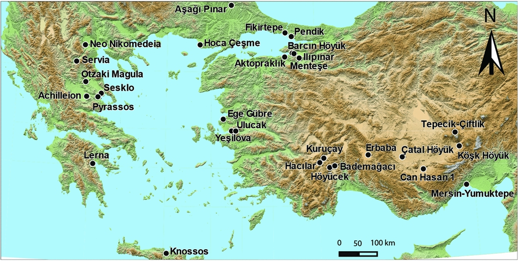
This article deals with patterns of settlement layout on a regional level, using these to infer overall patterns of social organisation. A comparative approach is applied, taking an Aegean perspective while simultaneously considering developments in Central Anatolia, western Anatolia and Greece from about 6700 to 5500 cal BC (Figure 1). The most salient factors and trends of settlement layout developments on the regional scale are identified using multivariate statistics, and these are compared with local developments on individual sites. They are then put into context with the overall processes associated with the expansion of Neolithic ways of life into Europe.
Area of investigation, showing the sites included in the analysis.

Theoretical foundation
Most studies of internal settlement layouts rest on the implicit or explicit premise that built space is in some way related to the shape of the social relations of the inhabitants (Hillier & Hanson Reference Hillier and Hanson1984; Souvatzi Reference Souvatzi2008; Fisher Reference Fisher2009). Starting from practice theory, several approaches underline the simultaneity of architecture and settlement layout in both reflecting and reproducing social order (Bourdieu Reference Bourdieu1977, Reference Bourdieu1990 [1980]; Giddens Reference Giddens1984). Settlements are not only set up according to existing social structures but also take part in the shaping of identities and social relations. Although architecture is often remodelled and altered, buildings and the spaces they form create a relatively stable material arena within which social roles and relationships are negotiated. Such built spaces promote routines and habits of practice, frequently motivating and enforcing some ways of interaction while hindering or even blocking others. Thus, an analysis of space syntax can be used to infer patterns of social organisation. Nevertheless, the effects of multiple local agencies, and of individual histories and contexts, mean that such a space syntax approach does not permit directly drawn conclusions about social organisation based on the concrete layouts of individual settlements. A systematic analysis of settlement organisation patterns at a regional scale can, however, identify overall trends affecting those local contexts and histories.
Data
Settlement pattern data from Neolithic sites dated to 6700–5500 BC in the Aegean region were analysed in order to identify dominant factors structuring the data. This period witnessed the founding of the earliest continuously settled Neolithic villages in Western Anatolia and Greece, and a marked discontinuity around 5500 BC (Perlès Reference Perlès2001; Reingruber Reference Reingruber2008; Çilingiroğlu Reference Çilingiroğlu2009; Düring 2011), which is best visible in Western Anatolia, but also in Greece (Parzinger Reference Parzinger1993).
A total of 71 published settlement plans were collected (Figure 1; Table S1 in online supplementary material), documenting excavation activities of varying quality and extent. In some cases large areas were exposed and recorded, while at other smaller excavations, only a few houses were identified and excavated. It is important to note that with smaller excavations there is an increased likelihood of missing critical variation and detail in settlement layout. For example, the presence of free-standing houses and the regularity of their arrangement may be discernible in small excavations, but not the overall symmetry of architecture. Despite this potential source of bias—not at all uncommon in archaeology—correspondence analysis is able to extract meaningful patterns from such non-standardised units of investigation (Madsen & Petersen Reference Madsen and Petersen1984; Müller & Zimmermann Reference Müller and Zimmermann1997).
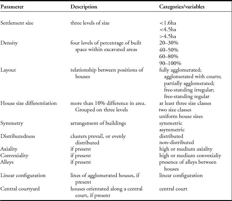
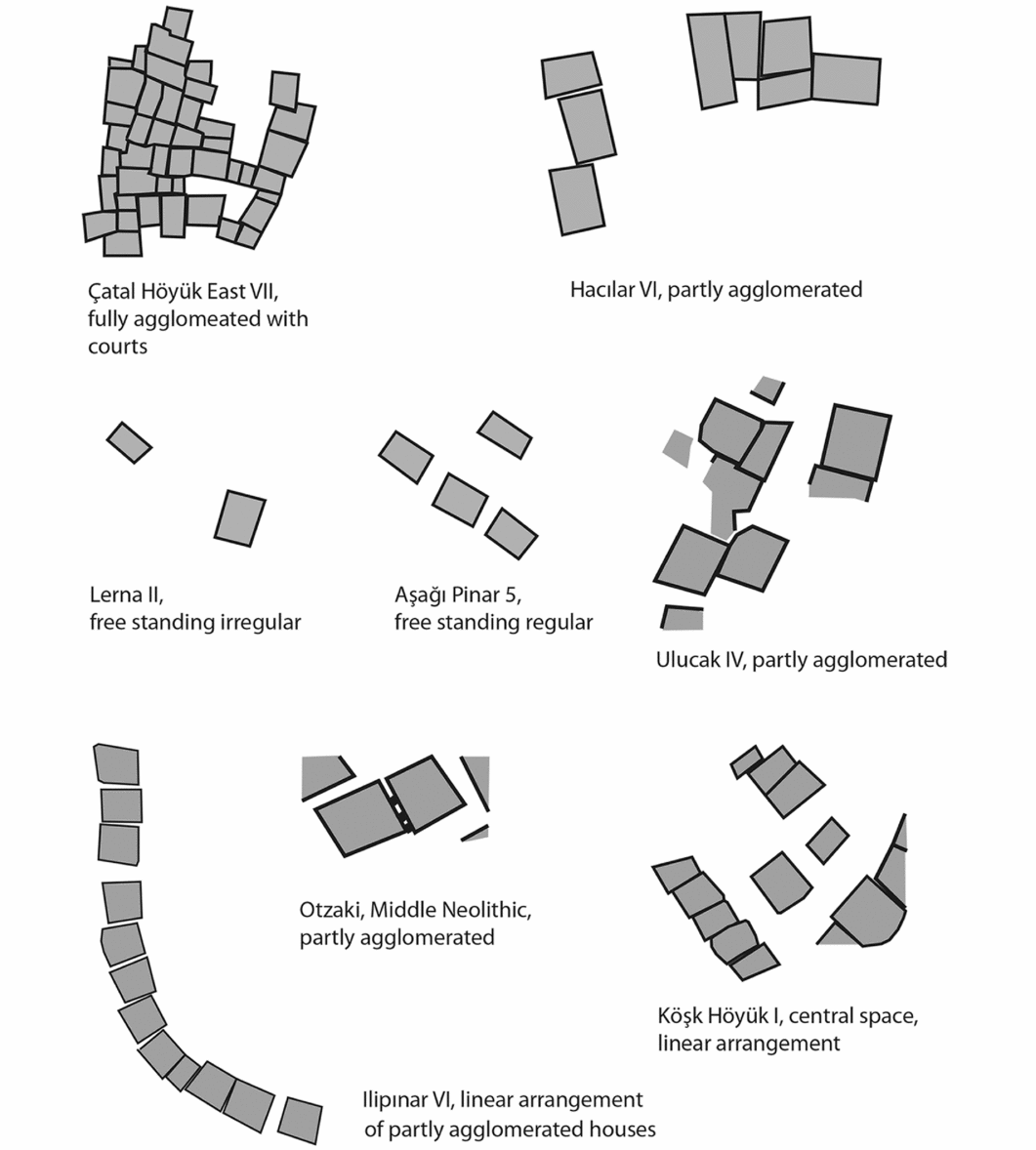
The parameters used to classify settlement layouts (Table 1) are partly orientated towards the characteristics of the dataset, and partly borrowed from a similar work by Banning developed from southern Levantine settlements (Banning Reference Banning2010). The first set of variables refers to the size of a settlement, which is always a rough estimation, based on the extent of the spread of material culture present on a site, as reported in the literature. Accordingly, a coarse classification into three size classes was applied, reflecting natural breaks in the dataset. Building density refers to the percentage of space covered by buildings in the excavation plan. For layout, settlement plans were grouped into five categories, from ‘fully agglomerated’, ‘agglomerated with courts’ and ‘partly agglomerated’ (at least two houses agglomerate, while others do not), to ‘free-standing irregular’ and ‘free-standing regular’ (Figure 2). The term ‘regular’ refers to the presence of uniform house orientation and the presence of house rows. House size differentiation refers to the variable of uniform vs differentiated architecture. Two houses are considered to have different sizes when they differ in area by more than 10 per cent.
The parameters of investigation and the variables of the analysis.

Examples of settlement plans from the area of investigation (after Mellaart Reference Mellaart1967, Reference Mellaart1970; Milojčić Reference Milojčić1983; Karul et al. Reference Karul, Eres, Özdoğan, Parzinger, Fassbinder and Becker2003; Vitelli Reference Vitelli2007; Roodenberg & Roodenberg Reference Roodenberg and Roodenberg2008; Çilingiroğlu Reference Çilingiroğlu2009; Öztan Reference Öztan, Özdoğan, Başgelen and Kuniholm2011. For references, see Table S1 in online supplementary material).

Symmetry, distributedness, axiality and convexiality are variables that refer to the overall structure of a settlement, following Banning (Reference Banning2010). In this analysis, ‘convexiality’ refers to a dominance of concentrated open-air spaces, which create distinct, confined arenas between houses or walls—the very opposite of ‘axiality’, which creates wide open spaces with extended visibility. Thus, these parameters can only be assessed in those cases where a larger part of a settlement is uncovered. Finally, the analysis considered the presence of a large central courtyard; agglomerated houses that form a line; and alleys between houses that exceed the gap between two parallel pairs of houses and also do not include the presence of free axes in a settlement with regular, free-standing houses. This set of qualitative parameters enables a structural analysis of internal settlement patterns.
Analyses
Correspondence analysis (see Greenacre Reference Greenacre1984, Reference Greenacre1993; Müller & Zimmermann Reference Müller and Zimmermann1997) was employed to explore the data for patterns of internal settlement organisation. This multivariate statistical procedure was chosen because it is robust with regard to data structure and deals with categorical data. The calculations were carried out using CAPCA-Module, version 2.11 (Madsen Reference Madsen2015) on the basis of co-occurrences of the traits present in each settlement. Details are provided in the online supplementary material: Tables S2 & S3.
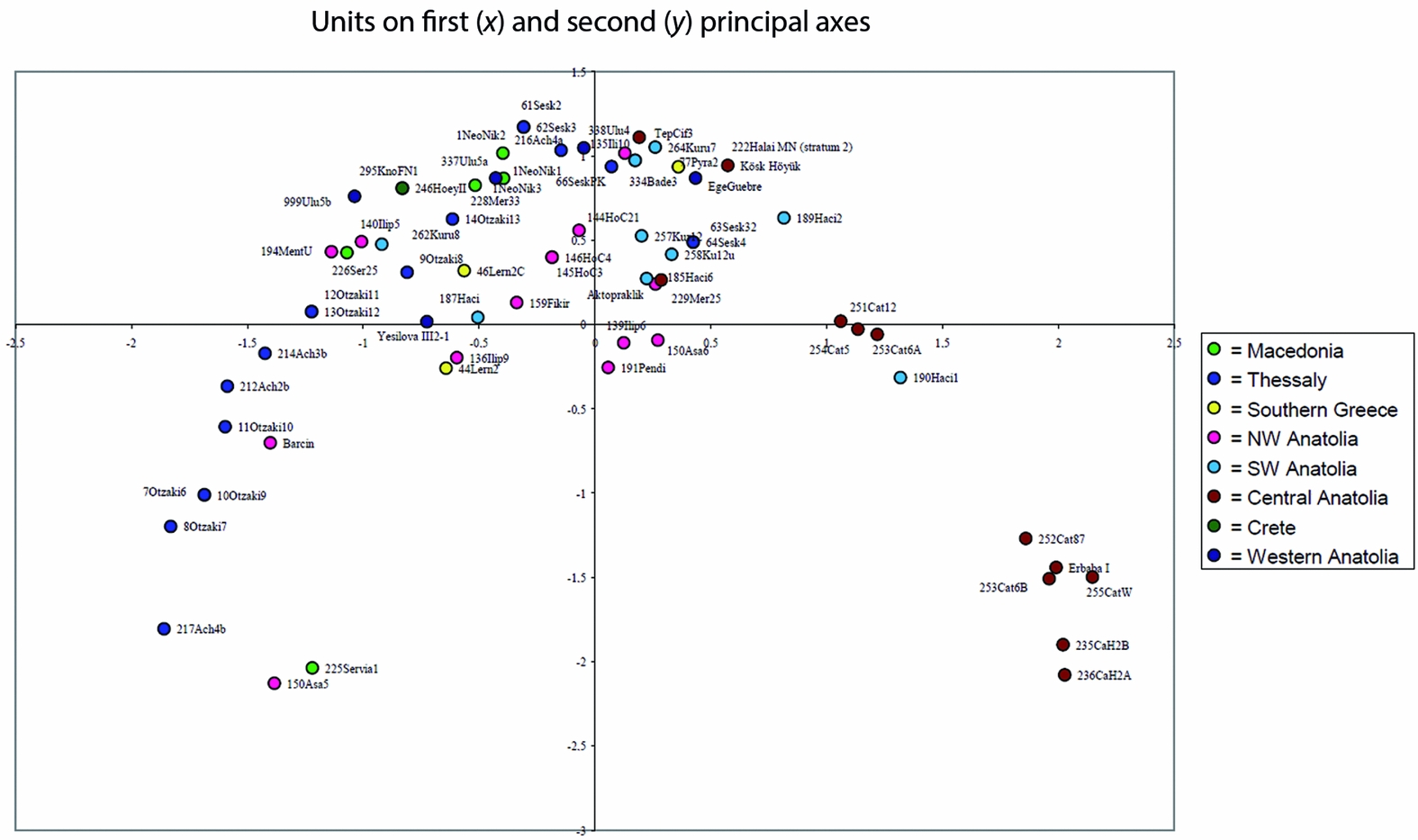
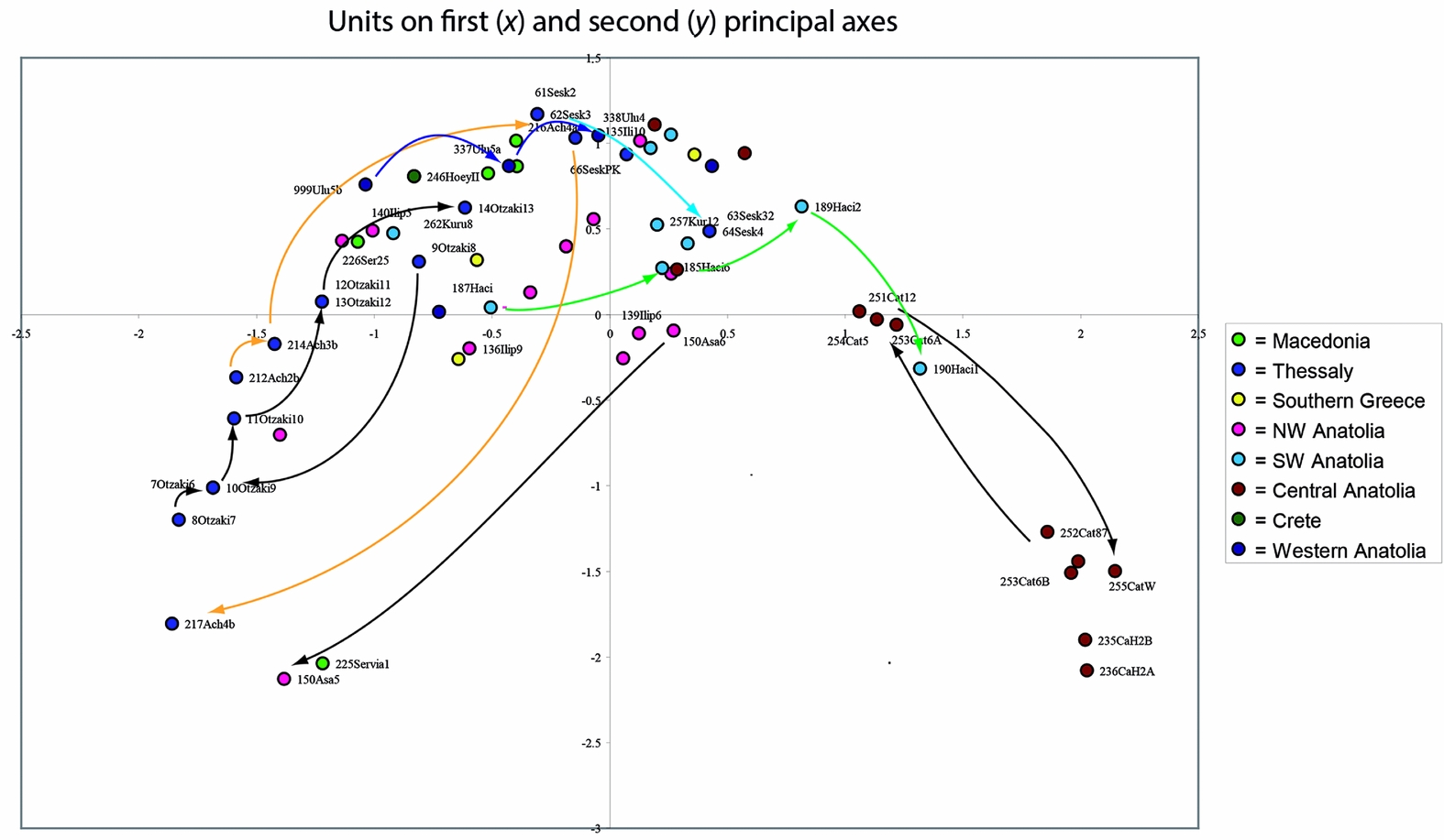
Theoretically, the settlement plans could be ordered according to numerous different parameters; that is, they have many dimensions in which one could find meaningful patterns. Correspondence analysis synthesises those dimensions and detects those factors that create the greatest degree of differentiation between the settlements, and displays them in a metric order relative to those factors. Four factors were calculated; these explain 44.75 per cent of the variation in the dataset. Figure 3 shows the two most salient factors, accounting for 14.74 per cent and 11.37 per cent of the data variation. Thus, the proximity of the points on the correspondence map in Figure 3 reflects the similarity of the settlement plans.
Correspondence analysis (performed with CAPCA; Madsen Reference Madsen2015) of the parameters of settlement layout shown in Table 1. Display of units in relation to the first (x-axis, 14.74% explanation) and second (y-axis, 11.37%) calculated factors.

The settlements are aligned along the most salient factor, represented by the x-axis. Along the second factor, represented by the y-axis, the majority of settlements are placed on the upper part of the graph. The data cloud in Figure 3 is mostly continuous, although on the right side, there is a marked gap separating a group of Central Anatolian settlements; a second, slightly isolated group is also visible, containing Central Anatolian settlements plus south-west Anatolian Hacılar I.
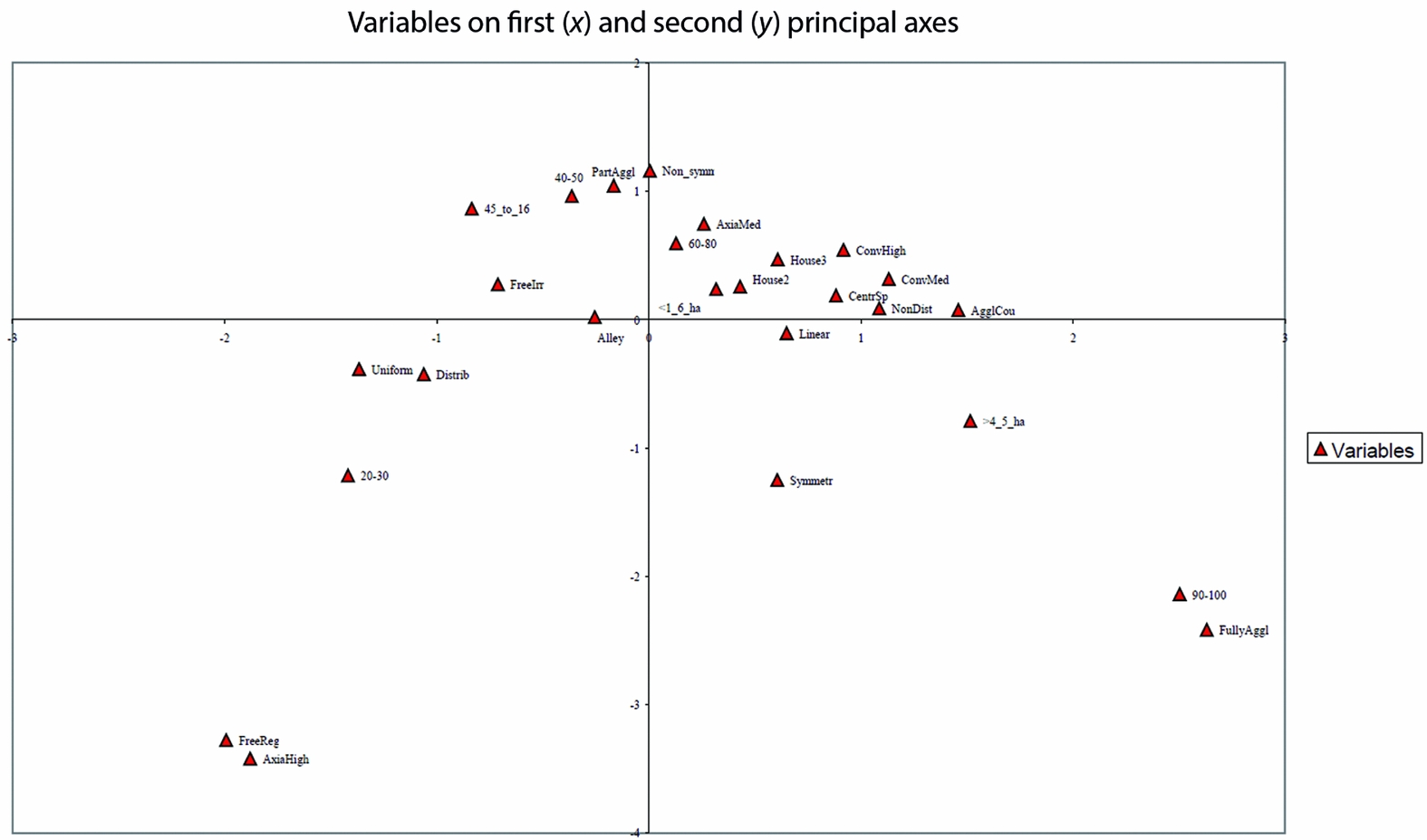
The relative position of variables in Figure 4 refers to their frequency of occurrence in the context of the settlement units (Figure 3), and the graph helps to interpret the factors extracted by the analysis. Starting with the first factor (the x-axis), moving from right to left, we find a sequence from ‘fully agglomerated’, ‘agglomerated with courts’ and ‘partly agglomerated’, to ‘free-standing irregular’ and ‘free-standing regular’. In the same direction, there is the sequence from very densely built settlements on the right to less densely built settlements on the left (see percentage values in Figure 4). The largest size group (>4.5ha) is located on the right; on the left side, settlements are smaller (1.6–4.5ha), while the smallest settlements seem to appear everywhere, and thus this trait (<1.6ha) is located in the middle of the graph. Concerning the differentiation of house sizes, ‘three or more size classes’ (House 3) is located to the right of ‘two size classes’ (House 2), which is again located to the right of the trait ‘uniform house sizes’. For convexiality and axiality, we find a succession from the right to the left, which reads: ‘highly convex’, ‘moderately convex’, ‘moderately axial’, ‘highly axial’. ‘Non-distributed’ settlement arrangement is located to the right, and ‘distributed’ settlement arrangement to the left of the graph. The traits ‘central court’, ‘alley’ and ‘linear alignment’ are grouped together on the right side of the central cluster.
Correspondence analysis (performed with CAPCA; Madsen Reference Madsen2015) of the parameters of settlement layout shown in Table 1. Display of variables in relation to the first (x-axis, 14.74% explanation) and second (y-axis, 11.37%) calculated factors.

This arrangement of variables indicates that the first factor of the analysis—accounting for almost 15 per cent of the variation—refers to the difference between, on the one hand, large, agglomerated, densely built, internally differentiated settlements that highlight convex spaces, and, on the other, smaller settlements with distributed, more or less regularly placed, free-standing houses of uniform size that highlight axial spaces. With regard to the second factor (the y-axis in Figure 4), the variable placement indicates that ‘symmetry’ of settlement plans is located on the lower part of the graph, and ‘asymmetrical’ settlement plans on the upper part. On the lower part of the graph, we find fully agglomerated or free-standing regular arrangements, whereas on the upper part, we find partly agglomerated and free-standing irregular. Uniform house sizes are located on the lower part of the graph, non-uniform ones (two, or three or more, house sizes) on the upper part. It can therefore be deduced that this second factor, represented in the y-axis, is that of order, symmetry and, more generally, a regular structure on the lower part of the graph vs lack of order, asymmetry and non-uniformity on the upper part.
Discussion
We are dealing here with two different kinds of factors. One, the secondary factor, the y-axis, refers to the mode of social organisation, namely the question of overall control governing the house position and arrangement; in other words, the presence or absence, or rather the strength, of settlement-wide social institutions. By contrast, the primary factor, the x-axis, represents different specific cultural forms of organisation of space. The distribution of sites along this axis seems to have a geographic significance, as the right side is dominated by Central Anatolian settlements; these extend into the central part of the graph. The south-western Anatolian settlements, such as Hacılar, Kuruçay and Bademağacı are mostly located in the centre, while the western Anatolian and southern Greek sites are located in the centre with a tendency towards the left part of the graph. The north-western Turkish settlements and the northern Greek sites are concentrated on the left side, with a tendency towards the left-centre part of the graph. Thus, the alignment of settlements along the arc-like data cloud shows a clear geographic tendency from the south-east on the right side to the north-west on the left.
The x-dimension is therefore interpreted to represent the difference between large, agglomerated, internally differentiated settlements, creating convex spaces, and smaller settlements with distributed, more or less regularly placed, free-standing houses of uniform sizes, creating axial spaces. This difference, showing a geographic trajectory, is related to historically located, specific cultural traditions. On the right side of the graph, we find settlements that Düring (Reference Düring2006) has described as Central Anatolian ‘clustered neighbourhoods’, namely several layers of Çatalhöyük East and Erbaba, but also Çatalhöyük West and Can Hasan 1. As a heuristic concept, this first type of settlement will be termed the ‘Anatolian village’ (although significant variability is also present in Anatolia).
The other end of the spectrum described by the first factor of the correspondence analysis includes settlements with free-standing, more or less regularly arranged, mostly uniform houses, such as Achilleion 4b (Gimbutas et al. Reference Gimbutas, Winn and Shimabuku1989), Otzaki (Area 1, Planum 6, Milojčić Reference Milojčić1983), Servia 1 (Ridley et al. Reference Ridley, Wardle and Mould2000) or Asagi Pinar 5 (Karul et al. Reference Karul, Eres, Özdoğan, Parzinger, Fassbinder and Becker2003). These represent a pattern known from the later Neolithic Balkan region, as for example in the sites of Okolište, Obre II, Divostin (Hofmann Reference Hofmann2013), Iclod and Poduri (Mischka Reference Mischka and Hansen2010) or Pietrele (Hansen et al. Reference Hansen, Reingruber and Toderaş2009), in Parța, Uivar (Draşovean & Schier Reference Draşovean, Schier and Hansen2010) and Drama (Lichardus et al. Reference Lichardus, Fol, Getov, Bertemes, Echt, Katincarov and Iliev1996). The pattern is uncommon in Anatolia, and this type of settlement will hence be termed the ‘Balkan village’.
It is instructive to note the specific ways in which these two historically situated cultural variants of overall social institutions are actually expressed. In the case of the Anatolian village, the agglomeration of houses restricts and physically predetermines the possibilities for forms, sizes and positions of houses. The agglomeration type also promotes the creation of convex spaces, often in the form of courtyards between the houses. The regular placement of free-standing houses in the Balkan village reflects a different kind of overall order. Here, no physical constraint prevents deviation from the general structure. There is, in theory, a higher degree of autonomy for every single house. Two very different concepts of control of space are apparent in the respective settlement models: convex spaces partition areas, creating units within a settlement community, perhaps on several scales, as, for example, discussed for the ‘clustered neighbourhoods’ (Düring Reference Düring2006). Axial spaces create a wide but rather uniform visibility throughout the settlement. The absence of a central point to such a regular, linear layout furthers an inter-house uniformity, also expressed by the uniform house sizes. Thus, the Anatolian village and the Balkan village types represent two distinctly different variants of overall organisation of space, referring to different forms of settlement-wide social institutions. The Anatolian village would indicate a multi-level organisation, with (at least) household, neighbourhood and settlement levels. The Balkan village indicates a two-level organisation (household and settlement).
Neither of these two ‘ideal types’, however, represents an exclusive principal settlement organisation in either Central Anatolia, or in Greece and the north-west of Turkey. The distribution of data points in Figure 3 indicates that there is a continuous field of variation extending from one ‘ideal type’ to the other, with the exception of a slight discontinuity separating the majority of central Anatolian sites to the right of the graph.
Keeping in mind that the arc-like shape of the data cloud (Figure 3), from the right to the left, represents a gradual sequence from the south-east to the north-west, it is interesting to note that between the two variants (Anatolian and Balkan villages) there is a large area—indeed, including the majority of sites in the region—which is characterised by a lack of a strong overall structuring principle. On the contrary, in these settlements, there is a varying mixture of components that are characteristic for both sides of the graph: a mixture of free-standing houses and agglomerated parts of a settlement, of uniform houses and differing house sizes, of convex spaces and axiality. Indeed, with a few exceptions, none of those settlements located in the middle of the first axis show stability of any settlement layout from one phase to the next. Also, although not part of this analysis, there is a curious variability of house forms and building techniques, with mud-brick, post-built houses or light wattle-and-daub-constructions found together in the same regions, often even in the same settlements (e.g. Ilıpınar, Hacılar, Otzaki or Achilleion; see Reingruber Reference Reingruber2008; Lillie et al. Reference Lillie, Budd, Alpaslan-Roodenberg, Karul and Pinhasi2012).
Settlements resembling the Anatolian village obviously lasted a lot longer than those of the Balkan village type. The settlement cluster to the right of the graph spans the sequence of Çatalhöyük East until Level VII, dating prior to 6500 BC, but also the later Çatalhöyük, Erbaba and Can Hasan 1. The settlements on the left edge of the graph start later, dating clearly after 6000 until around 5500 BC. So, although neither of the two factors calculated refers directly to chronology, the settlement pattern type represented on the right side (the Anatolian village) reaches back to a time before there is Neolithic settlement to the west of Central Anatolia. Thus, the shape of the data cloud indicates that in this region, and during the process of expansion to the west, the pattern of overall social control referred to as the Anatolian village is lost, or at least becomes less important in most of the regions and for a considerable period, until a new overall structure (the Balkan village) is formed. In Greece, however, as in the Balkans, this regularity of house placements indicating overall order is much less frequent and much less durable when compared to the Anatolian village. This is reflected in Figure 3, where most settlements on the left side, the Balkan village side, are actually located towards the upper part of the graph. Those settlements do show free-standing houses, dispersed arrangements and much free space within the site, but also less regular house placements, such as diverse orientations or singular instances of house agglomeration (e.g. Otzaki, Area I, Planum 8; see Milojčić Reference Milojčić1983).
To sum up, the dominant state on a regional scale is a tension between an older, Central Anatolian mode of overall social organisation that is (and remains) strongest in the south-east, and a younger one that is strongest in the north-west. In the region in between, characteristics of these two poles are present and mixed to varying degrees, but signs of lasting overall social organisational principles are very weak.
Individual histories
As we are mostly dealing with tell settlements, it is possible to follow the specific developments of settlement organisation from level to level, and to compare these individual histories in the context of the overall structure (Figure 5). At Çatalhöyük East, the Anatolian village principle is dominant until Level VII, but from Level VIA onwards (about 6500 BC), the layout of the settlement loses stability (see Hodder Reference Hodder2014; Marciniak et al. Reference Marciniak, Barański, Bayliss, Czerniak, Goslar, Southon and Taylor2015). Large courts become more important, and move these settlements towards the centre of the graph. Çatalhöyük West (Biehl Reference Biehl2012), however, is again placed on the right side of the graph.
The directions of stratigraphically related settlements on single tell sites indicating individual histories with respect to their placement in the correspondence analysis displayed in Figure 3; the same factors are displayed.

The sequence at Hacılar (Mellaart 1970) is located in the central part of the graph, while Hacılar 1, with its largely agglomerated layout, shows a tendency towards the Anatolian village. Kuruçay (Duru Reference Duru, Başgelen, Özdoğan and Kuniholm2012) and Ilıpınar are located within the central cluster. Aşağı Pinar starts with a partly agglomerated layout, and is thus located in the central cluster, but is transformed into a Balkan village type over time (Karul et al. Reference Karul, Eres, Özdoğan, Parzinger, Fassbinder and Becker2003). The opposite is true for Ulucak in western Anatolia (Çilingiroğlu Reference Çilingiroğlu2009) and for the Thessalian sites of Achilleion (Gimbutas et al. Reference Gimbutas, Winn and Shimabuku1989), Otzaki (Milojčić Reference Milojčić1983) and Sesklo (Kotsakis Reference Kotsakis, Tasic and Grozdanov2006). These all start out structured in the mode of Balkan villages, but characteristics associated with the Anatolian village become continuously stronger, albeit with fluctuations, over time, and the settlements move towards the centre of the graph.
This short account demonstrates how individual histories of settlements, although driven by site-specific or local developments, are better understood when viewed against the wider context of regional trends. We see different developments active at different scales. The presence of individual agencies, local economic or environmental patterns cannot, however, totally suppress the salience of the overall trends identified by the correspondence analysis.
Traditions and regional interaction
The Balkan village and the Anatolian village represent specific forms of spatial organisation of settlements that can be regionally and chronologically located. It seems plausible to connect the Anatolian village, with its distinct form, to a kind of social organisation whose structure was shaped by millennia of (more or less) sedentary village life and centuries of more complex and extensive social relations, gradually rising group sizes, homogenisation of settlement layout, house forms and building techniques. Taking Çatalhöyük East, Erbaba and Can Hasan 1 as the most representative examples of this type of settlement, a connection to Central Anatolian predecessors, such as Aşıklı Höyük (Özbaşaran Reference Özbaşaran, Özdoğan, Başgelen and Kuniholm2012), and Near Eastern Pre-Pottery Neolithic traditions is probable—a connection that is also witnessed by parallels in the form of architecture, settlement organisation and sizes to late Pre-Pottery Neolithic B sites such as Ain Ghazal, Ba'ja or Sabi Abyat (Akkermans & Schwartz Reference Akkermans and Schwartz2009; Banning 2012). It is therefore proposed that the Anatolian village is a local expression of a distinct tradition that builds to a large extent on a Near Eastern Neolithic heritage.
The Balkan village, however, refers to a different tradition of Neolithic society. In terms of domesticated animals and plants and various components of material culture, this second tradition also builds upon a Near Eastern Neolithic heritage, and the tell-forming extreme sedentism is the same as in Central Anatolia, yet a different mode of intra-site organisation is in evidence. One possible reason for such a difference could be that the communities founding new settlements on the European shores derived from a different tradition of Near Eastern Neolithic communities; for example, from the southern Levant. Another possible explanation is that the newly formed Neolithic communities in north-western Turkey and Greece still derived from the Central Anatolian communities, as indicated by similarities in material culture (Özdoğan Reference Özdoğan and Krauss2011), but underwent a drastic change in their social organisation. This second option is supported by the structure of the data cloud in Figure 3, which mostly shows a continuous transformation of traits of spatial organisation, reaching from the Anatolian village to the Balkan village, from south-east to north-west—coinciding with the general direction of Neolithic transition in the region. The graph also indicates that along this transformation, the strength of overall, settlement-wide institutions is weakened and lost, until the new Balkan village configuration reappears in the north-west. In this interpretation, the Balkan village type of social organisation would have developed out of the Anatolian village type, a process during which overall social institutions dissolved. If that is the case, what caused these changes in social organisation? Here, it is instructive to look more closely at the concrete differences between the Balkan and Anatolian village types. The most marked traits are smaller settlement sizes, more autonomous houses and a less stable spatial organisation, which frequently changes its shape. Even if it is somewhat speculative (we actually have almost no data on the social organisation of late Mesolithic hunters and gatherers in the region), based on general or probabilistic considerations of mobile hunter-gatherer social organisation in periods of low-density populations (e.g. Kelly Reference Kelly1995: 215–59), one could argue that these specific traits might be a heritage referring to earlier Mesolithic modes of social organisation. The Balkan village model of early Neolithic spatial organisation shows stronger impact from a local Mesolithic heritage than does the Anatolian village. If so, the most probable reason for the changes observed would be the inclusion of people with a more recent hunter-gatherer background. For the settlements on the upper part of the graph especially, the unstable and heterogeneous settlement layouts could very well indicate a co-residence of individuals or households with very different cultural and social backgrounds, a situation where different norms and practices met, interacted and created new communities.
Arguably, such a model of social transformation would also work without including a Mesolithic component. In any case, ‘pure’ Neolithic communities could very well be thought of as dynamic, ever-changing and culturally heterogeneous social groups. When studying Neolithic communities, there is a curious tendency to assume the presence of stable, homogeneous and coherent social groups as a default configuration for settlement inhabitants. In fact, an ever-changing, regionally and locally diverse mixture of different traditions, habits and practices, as dominates western Turkey and the Aegean region in the early Neolithic (based on interpretation of Figures 3–5), points towards inhomogeneous and unstable communities. In times of rapid expansion of new practices around the introduction of horticulture and herding, a high degree of individual mobility and frequent mixing of populations should actually be seen as the more probable social configuration, whether or not it is thought to have included a stronger Mesolithic heritage. Bhabha's (Reference Bhabha2010) concept of hybridity comes to mind, where different cultures are not ‘melted’ or tensions ‘resolved’, but rather form a heterogeneous mixture; a new form of community and social practice emerges, which challenges routines and security, but opens up much potential for creativity.
Highly mobile individuals from different backgrounds, and thus more heterogeneous, intermixed communities, can be seen as the mechanism by which those local and regional trajectories of changing settlement configuration are actually driven. Such a view does not contradict the demic diffusion model, because the latter works on a much larger scale. It is, however, exactly this large-scale perspective that often seems to favour unjustified ideas about culturally and biologically homogeneous social groups as agents in the model. Such concepts have more recently been supported by aDNA analyses (Brandt et al. Reference Brandt, Haak, Adler, Roth, Szécsényi-Nagy, Karimnia, Möller-Rieker, Meller, Ganslmeier, Friederich, Dresely, Nicklisch, Pickrell, Sirocko, Reich, Cooper and Alt2013; Haak et al. Reference Haak, Lazaridis, Patterson, Rohland, Mallick, Llamas, Brandt, Nordenfelt, Harney, Stewardson, Fu, Mittnik, Bánffy, Economou, Francken, Friederich, Pena, Hallgren, Khartanovich, Khokhlov, Kunst, Kuznetsov, Meller, Mochalov, Moiseyev, Nicklisch, Pichler, Risch, Rojo Guerra, Roth, Szécsényi-Nagy, Wahl, Meyer, Krause, Brown, Anthony, Cooper, Alt and Reich2015; Szécsényi-Nagy et al. Reference Szécsényi-Nagy, Brandt, Haak, Keerl, Jakucs, Möller-Rieker, Köhler, Mende, Oross, Marton, Osztás, Kiss, Fecher, Pálfi, Molnár, Sebők, Czene, Paluch, Šlaus, Novak, Pećina-Šlaus, Ősz, Voicsek, Somogyi, Tóth, Kromer, Bánffy and Alt2015) proposing that the Early Neolithic populations in Central Europe, the Carpathian Basin and north-western Anatolia (Mathieson et al. Reference Mathieson, Lazaridis, Rohland, Mallick, Patterson, Roodenberg, Harney, Stewardson, Fernandes, Novak, Sirak, Gamba, Jones, Llamas, Dryomov, Pickrell, Arsuaga, de Castro, Carbonell, Gerritsen, Khokhlov, Kuznetsov, Lozano, Meller, Mochalov, Moiseyev, Guerra, Roodenberg, Vergès, Krause, Cooper, Alt, Brown, Anthony, Lalueza-Fox, Haak, Pinhasi and Reich2015) seem to represent clearly different biological lineages to the Central, Western and Northern European Mesolithic populations, more or less excluding a significant genetic contribution of the latter. It is still unknown, however, how these Neolithic populations entering south-eastern and Central Europe were actually formed, and which role Anatolian or Aegean hunter-gatherers played in this process. The wider range of haplogroups discernible in the Central European Neolithic sample does not, at least, contradict a more heterogeneous and dynamic history of these populations.
Conclusion
A multivariate analysis of internal settlement organisation revealed an overall structure dominated by two factors, one of which reflects the presence or strength of settlement-wide social institutions, while the second identified two different, historically located types of settlement layout, termed the ‘Anatolian village’ and the ‘Balkan village’. The Anatolian village is connected to Near Eastern Pre-Pottery Neolithic traditions. Overall social control is secured through an extreme concentration of habitation, convex spaces and a temporal stability of form and position of houses. In the north-west (Greece and north-western Turkey), a new model of settlement-wide social organisation was established: the Balkan village. This featured free-standing, more or less regularly placed, uniform houses, axial spaces and a less centralised control of space. These Balkan village settlements were rather unstable: at most sites, a regular layout was not repeated, even in successive layers. Notwithstanding the lack of data characterising local Mesolithic populations, it is argued that the Balkan village mode of social organisation shows a stronger heritage of mobile, small-scale hunter-gatherers than the Anatolian model.
Between the two regionally located types of social organisation there is a large transitional space, in which overall social institutions seem to be weak, expressed by heterogeneous, varying and unstable settlement layouts. It therefore seems plausible to argue that the northward and westward expansion of Neolithic settlement happening around 6500 BC is connected to a weakening of social institutions that had prevailed in Central Anatolia. This created a third space where a hybridisation of traditions stemming from several different sources, be it Near Eastern Neolithic communities or local hunter-gatherers, constituted new, dynamic societies.
Supplementary material
Supplementary material for this article can be found at http://dx.doi.org/10.15184/aqy.2016.170