


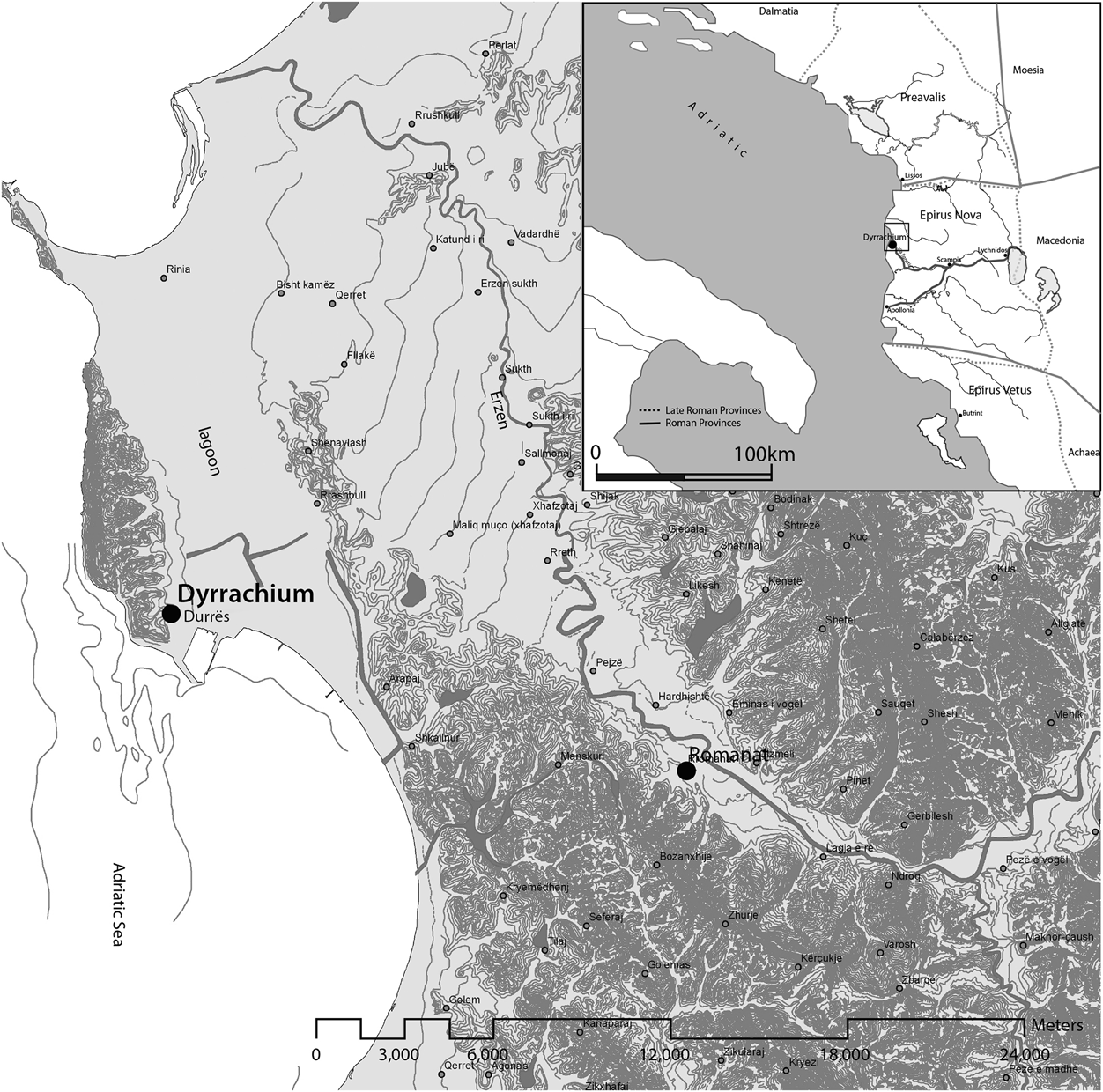
The modern city of Durrës is situated exactly where the ancient town of Epidamnos/Dyrrachium lay. It is located at the southern end of an elevated peninsula that extends to the north and northwest, and at the southwestern edge of an inland lagoon that extends to the north and east (Fig. 1).Footnote 1 This physical setting proved to be important for the city's development and changing uses of the landscape. The surrounding area has few sources of drinking water. The nearest supply is in the Boreas Mountains, ca. 2 km north of the city.Footnote 2 The other known source is the River Erzen (the ancient Ululeus), whose source has been identified near Romanat, some 15 km to the east.Footnote 3 The Adriatic Sea to the west and the lagoon to the east created not only an excellent defended position but also easy communications for trade and fishing resources for the local economy.
Location of Dyrrachium in relation to the surrounding landscape. (Map after Forsén et al. Reference Forsén, Shkodra-Rrugia, Korhonen, Shehi, Ruka, Tikkala, Lamboley, Përzhita and Skenderaj2018, fig. 1, used with permission; inset map by B. Shkodra-Rrugia.)
Though the city of Epidamnos was founded as a Corinthian/Corcyrean colony in 627 BCE, archaeological evidence from the city and its territory dates back to the 3rd millennium BCE.Footnote 4 Located in a liminal position as a port city on the eastern Adriatic coast, it developed gradually. From the 3rd c. BCE, now known as Dyrrachium, it came under increasing Roman influence, until it was eventually declared a colony.Footnote 5 A massive Trajanic–Hadrianic program of urban development gave the Roman city its principal layout and monumentality. The epigraphic evidence has shown that the main monumental buildings – the Hadrianic aqueduct,Footnote 6 the amphitheater, the public bath, the library – and a number of religious buildings are connected to this construction program.Footnote 7 Archaeological excavations are continuously producing better-stratified data and a clearer understanding of the urban layout, which was established on an orthogonal plan (Fig. 2).Footnote 8 Significant wealth is also reflected in the luxurious residences and villas that expanded outward from the public center to the northern suburbs of the town.Footnote 9
Plan of Dyrrachium showing the sites mentioned in the text. Sites 01–15 are Roman features. Sites 001–007 belong to the newly identified Late Roman phase. The baths discussed in this article are at 001, in the center of the city. (Plan by B. Shkodra-Rrugia; street grid after Shehi Reference Shehi2007 and Shehi Reference Shehi, Përzhita, Gjipali, Hoxha and Muka2014.)

The building activity that was widely recorded elsewhere in the Roman provinces during the Severan period does not seem to have been as spectacular at Dyrrachium.Footnote 10 It is archaeologically identifiable mainly through the renewal of earlier monuments. Alexander Severus apparently had to restore the aqueduct constructed for the Dyrrachians by the emperor Hadrian.Footnote 11 The restoration of deteriorated sections of the Roman road that began at Dyrrachium can also be associated with Alexander Severus's building program.
The administrative reorganization of the Roman Empire at the end of the 3rd c. or beginning of the 4th c. CE created the province of Epirus Nova from parts of the earlier province of Macedonia (Malal. 13.42.188). The rise of Dyrrachium's political status (Not.Dign.Or. 3.5–19) as the capital of this newly created province may have been followed by substantial transformations aimed at increasing urban space. Recovery was especially favored by the fact that the emperor Anastasius (r. 491–518 CE) was a native of the city (Malal. 16.A1–3.392). However, the city's continuous and uninterrupted occupation as a major population center down to the present day means that we have limited knowledge of its Late Roman phases and very few possibilities for large-scale excavations.
Bathing at Dyrrachium
As architectonic structures and important cultural spaces, baths were continuously shaped by social and urban changes. Baths at Dyrrachium date from at least the first half of the 1st c. CE.Footnote 12 The evidence is fragmentary but putting it together is important for contextualizing the new bath complex within the broader picture of bathing at Dyrrhachium and in relation to Late Roman urban developments.
At the southern edge of the Roman city, recent test trenches have revealed evidence of perhaps one of the earliest bath buildings in town, dated to the first half of the 1st c. CE (Fig. 2: 04).Footnote 13 A stretch of brick wall 13.40 m long, laid out 5 m from the reused remnants of the Hellenistic fortifications, seems to represent the outer wall of the bath building. The outer/southern face of this wall is fronted by a conduit and a possible east–west street. A hypocaust structure of circular plan could represent one of the hot rooms of the building, either a caldarium or a laconicum.Footnote 14 Such a round feature can be a chronological indication of the earliest bathhouse in the town, as it is widely considered to be of Greek origin and is rarely seen after the first half of the 1st c. CE.Footnote 15 Further traces of walls nearby might be the remains of a portico, which reused the abandoned Hellenistic fortifications,Footnote 16 and could indicate that the complex functioned as a harborside bath-gymnasium comparable to the Domitianic complex at Ephesus.Footnote 17
To the north of where the Roman city center is assumed to have been, the remains of a further public bathhouse have been located (Fig. 2: 05).Footnote 18 This seems to date to around the first half of the 1st c. CE and consists of a row of three north–south oriented rooms with hypocausts, another two small rooms and three praefurnia. These baths were inserted into a new area of the city plan, with a north–south orientation, that was created by leveling a late 2nd-c. BCE house.
The main public baths of the city (Fig. 2: 03),Footnote 19 still standing close to the supposed Roman city center, were laid out to the east of the best-preserved stretch of the Roman north–south street.Footnote 20 The excavated rooms consist of a row of three main square units aligned north–south, consisting of the pool of a frigidarium, a tepidarium, and a caldarium. Recently recorded evidence suggests a date before the Hadrianic period.Footnote 21
Other baths, though attested through limited investigations, may reflect the improved conditions following the construction of the Hadrianic aqueduct. In the far northern part of the city, indeterminate physical evidence for one possible bathhouse building is as yet unpublished. The two different structural parts – one a mosaic floor depicting a mythical marine celebration (Fig. 2: 06) and the other either an atrium or a hypocaust floor (Fig. 2: 07)Footnote 22 – are suggested to be part of the same monument, either a suburban mansionFootnote 23 or a private bathhouse.Footnote 24 Despite the very limited information, the size of the atrium/hypocaust space,Footnote 25 as well as the distinctive mosaic floor,Footnote 26 offers a glimpse of how rich and impressive both urban and suburban Dyrrachium might have been during the Hadrianic period.Footnote 27
Several other structural remains are recorded west of this find spot (Fig. 2: 08).Footnote 28 A hypocaust floor, two praefurnia, and a drain oriented east–west probably relate to another Roman bath building. The comparable form and construction technique of the drainage conduit, recorded underneath the sidewalk of the cardo to the west of the main public bath, suggest that the structures are part of the same phase of the urban layout.Footnote 29
A final discovery, interpreted as a Roman bathing area, consists of a hypocaust system divided into two different spaces by two heating conduits (Fig. 2: 09).Footnote 30 When this structure was built is uncertain but it was in use at least until the destructive events linked to the earthquake of 345/6 CE, at which point it changed function.
Late Roman Dyrrachium
The study of Late Roman urbanism is primarily focused on the changes introduced into the earlier Roman urban structure. These changes usually begin to occur during the Tetrarchy. The political and cultural transformations of this period are above all reflected in the development of a new Imperial architecture, favoring the political and ceremonial interaction between the emperor and the citizens.Footnote 31 This is the case for Sirmium and Thessaloniki in the Balkans, which received monumental palaces, baths, and circuses.Footnote 32 How are these broader developments reflected in our current knowledge of the archaeology of Dyrrachium?
Until recently, reconstruction and maintenance were the most frequently attested features at Dyrrachium for the 4th and 5th c. CE; these activities begin in the 3rd c. and continue into the 5th. Epigraphic evidence attests to the reconstruction of the Roman street that started in the city (possibly the Via Egnatia), as well as the aqueduct, by Alexander Severus (r. 222–35 CE).Footnote 33 Alterations datable to the second half of the 3rd c. CE have been documented in a bath structure discussed above (Fig. 2: 05).Footnote 34 Here, secondary walls seem to have subdivided the existing spaces. Further structural rearrangements, preserving the north–south orientation of the Roman phase and reconstructing the suspensurae and caldarium, using bricks with Christian symbols, ensured that these baths continued to function until the end of the 5th c. CE.Footnote 35 Further north, recently discovered Late Roman structures consisting of a decorative basin and a subsequent remodeling relate to modifications made to another Roman bath (Fig. 2: 09).Footnote 36 Indeed, investigations in the main public baths (Fig. 2: 03) have revealed convincing evidence for their continuous use up to the 5th c. CE.Footnote 37
In addition to rebuilding and maintenance, there is also evidence for the construction of new public monuments. John Malalas attributes a hippodrome and many other buildings in the city to Anastasius (Malal. 17.15.237), though it is possible that the emperor was actually responsible only for their reconstruction.Footnote 38 Archaeological work has documented the connection of another public monument, the Circular Forum, to Anastasius's building program.Footnote 39 The political horizons of this era, favored by Anastasius's local origins, gave Dyrrachium a new monumental and material aspect. The Circular Forum, at the core of the Late Roman urban center, reused existing Late Roman monuments in a unique architectonic shape with an asymmetrical design.Footnote 40
For the Late Roman period, there is better evidence for the extension of the city to the north, including into areas previously occupied by the Roman necropolis. This is attested by the recent discovery of the first documented phase of the Late Roman defensive system.Footnote 41 However, the chronology of this urban enlargement, despite considerable debate, has not yet been established by stratigraphic evidence.Footnote 42 Its north–south layout respects and builds on the existing Roman urban plan and street network. Other suggestive finds, albeit divorced from their original context, may relate to new building projects. A sculpted relief, reused in the northern gate of the medieval city wall, the “Porta Grande,” probably comes from an important public structure.Footnote 43 The iconographic scheme and the repertoire of Roman triumphal themes can be compared to those on the Arch of Galerius at Thessaloniki, constructed 298–303 CE.Footnote 44
In fact, several recent discoveries at Dyrrachium indicate that there was an important, previously unknown, urban phase between the Imperial period and the 6th c. CE.Footnote 45 These discoveries include the bath complex discussed below (Fig. 2: 001). This phase may also be linked to the identification of a stretch of opus mixtum wall, oriented north–south (Fig. 2: 005), recently redocumented as part of the stratigraphy recorded in the eastern part of the Late Antique Circular Forum.Footnote 46 The same north–south orientation is further attested by two new Late Roman brick structures, a segment of an open conduit (Fig. 2: 004) and another as yet uncertain structure, the function of which is also connected to water (Fig. 2: 003).Footnote 47 Beyond the city center, a Late Roman villa (Fig. 2: 007), dating between the 4th and 5th c. CE, has been found using aerial photographs and GPR.Footnote 48 Interpreted as a rich urban residence, this structure consists of a large square peristyle surrounded by a gallery and other structures.
All these features, representing either ex novo constructions or alterations to existing buildings, and in both cases preserving the urban layout of the Roman city, seem to represent a distinct urban phase between the Roman colonial city and that of the Anastasian/Justinianic period. This important Late Roman phase, the subject of an ongoing research project, is still in the first stages of recognition.Footnote 49 The recently discovered bath complex seems to fit within this context of urban realignments and changes.
Description of the new bath complex
The new bath complex is located very close to what is presumed to be the center of the Roman city (Fig. 2: 001).Footnote 50 It is positioned at the intersection between two known Roman streets. The alignment of the north–south street has been recorded archaeologically at the western entrance of the modern marketplace (Fig. 2: 10).Footnote 51 Remains of the east–west street, measuring 2.70 m wide, were revealed during a rescue excavation in 2005 further to the west (Fig. 2: 12).Footnote 52 That these roads were laid out within a wider Roman grid system is shown by a crossroads excavated to the northeast (Fig. 2: 11).Footnote 53
The long sides of the structure are oriented east–west, an orientation slightly affected by the difference in ground level (3 cm over a length of 5 m). The distinct east–west and northwest–southeast downslope of the city's topography strongly shaped the layout of the street network in different parts of the city, as well as the layout of its buildings.Footnote 54 The central and northern area is more closely oriented to the cardinal directions due to the almost flat terrain.
It is surprising that the new bath complex seems to be an ex novo construction, given the centrality of its position within the town. The site is surrounded by pre-existing structures and the densely occupied insulae of the Roman city (Fig. 3). A few meters north of site 001, previous excavations identified an underground conduit dated to the 2nd–3rd c. CE (Fig. 3: a).Footnote 55 Traces of another contemporaneous underground conduit oriented northwest–southeast, have been found to the northeast at a depth of 3.60 m (Fig. 3: b).Footnote 56 A wall segment in solid brick masonry, identified to the east of site 001 (Fig. 3: c),Footnote 57 could be part of the same monument. About 60 m to the northeast the structural remains of another public monument were discovered, consisting of a curved wall constructed entirely of bricks bonded with mortar (Fig. 3: 002).Footnote 58 This structure shares some of the same technical characteristics as 001, but in contrast appears to have been built by reusing earlier Roman masonry. The functions of both this earlier masonry and the later structure are as yet unclear. Explanations of the curved structure (phase 2) associate it with either a religious or a high-status public or palatial monument of the Late Antique period.Footnote 59 This feature lies relatively close to site 001 and could be part of the same complex, although its connection to 001 would need to be verified with further excavation.
The recently excavated bath complex (001) within its urban context. (Plan by B. Shkodra-Rrugia.)

Very limited physical evidence of the new baths is accessible at site 001. To date only a single section of the structure has been uncovered. This consists of a row of three rectangular spaces laid out parallel to each other: from north to south, these are designated Ia/Ib, Ic/Id, and II (Figs. 4–5). The walls dividing these spaces all run east–west, suggesting that the whole structure was aligned with the street grid, though, in the absence of the full plan of the complex, this must remain speculative.
Plan of the excavated portion of the bath complex. Shaded features are walls. (Plan by M. Nushi.)

Reconstructed elevation drawing through the excavated features (A–A’ on Fig. 4), looking west. (Reconstruction drawing by M. Nushi.)

A curious feature of the structure is the presence of an above-ground conduit running east–west between spaces Ic and II, with its sides formed by walls 3 and 4 (Fig. 6a). This conduit is documented to a height of 1.55 m; its maximum width is 0.90 m, though it narrows to 0.36 m wide at the base. It is constructed from ceramic tiles that are preserved due to the structure's reuse as a grave. Later intervention has worn away the lining of the conduit walls, though traces of hydraulic mortar survive in places beneath a thin layer of lime plaster that can be connected to the later reuse of the structure (Fig. 6b). This feature recalls the conduits of Roman aqueducts, which have a standard shape and structure, and this must have been a major water-supply conduit.Footnote 60 Such conduits were usually roofed by a vault, probably in this case also serving as the support of other superstructures. In addition to its primary function, this conduit may have served as a division between two main parts of the bath structure, the northern and the southern sections.
(a) The above-ground conduit between walls 3 and 4, looking west; (b) Detail of the bottom of the conduit, looking west. (B. Shkodra-Rrugia.)

The northern section of the building can be identified as the frigidarium, comprising a main hall (Ia), off which a bay extended to the west (Ib) and at least two pools opened to the south (Ic and Id) (Fig. 4). The main hall (Ia/Ib) measured at least 7 m in length (east–west) and 2–3 m in width (north–south), though only its southern wall survives (Fig. 4: 2). This wall is made of solid brick masonry, 1.30 m thick and preserved to a height of ca. 3.30 m. Its northern face preserves traces of fine wall plaster, painted in bands of three different colors (Fig. 7a). At the eastern end a niche is built into this wall, 0.90 m high × 0.45 m deep (Fig. 7b). The base of this niche is 1.35 m above the floor level. What survives of the floor of Ia is only the solid make-up layer of hydraulic mortar, which is traversed by an underground conduit (0.30 m wide × 0.20 m deep), running parallel to wall 2, 0.30 m north of it (Fig. 4).
(a) Elevation drawing of wall 2 in the frigidarium (B–B’ on Fig. 4), looking south. (Elevation drawing by P. Naipi.) (b) Detail of the niche at the eastern end of wall 2, looking southeast. (B. Shkodra-Rrugia.)

The southwest corner of the main hall is articulated by a massive pier of cruciform plan (Fig. 4: 1), indicating a cross-vaulted scheme. This pier divided the space and at the same time integrated the features around the main hall. It anchored at least three such features: the western bay (Fig. 4: Ib) and two cold-water pools (Ic and Id). The ground level of the western bay (Ib) steps up 0.61 m from the main hall (Fig. 5) and it is from this raised section that the pool in Ic was accessed.
The pool opening off the southern side of the main hall (Ic) measured 5 m in width and was articulated by massive piers at its northwest and southwest corners (Figs. 4–5: walls 1 and 3). This pool was connected to Ib as well as another probable pool to the west (Fig. 4: Id). Among the excavated features of pool Ic were large stretches of the floor paved in Proconnesian marble panels of various sizes (the largest measuring 91.5 × 82 cm; see Suppl. Fig. 2). Panels of the same marble were used on the walls (ranging in thickness from 4.5 cm to 5.5 cm), fixed in place with iron pins fastened with lead to the brick walls (Fig. 8). Though physically preserved up to 0.40 m in height, this revetment extended at least up to 1.98 m, to judge from the remaining iron pins. The wall revetment was sumptuously finished, based on the discovery of numerous fragments of marble molding (85 in total). These elements were unfortunately found redeposited in the subsequent fills related to the remodeling of the bath; none was found in situ. These decorative elements represent two different types: one type is an undecorated marble strip; the other is a carved marble framing element consisting of small alternating rectangles on either one side (Fig. 9: 1a–c) or both sides (Fig. 9: 2a–b). Both types may have been used to frame the plain rectangular slabs; alternatively, a combination could have been used to create horizontal decorative moldings. The marble flooring and wall revetment were fixed in place with hydraulic mortar made of a waterproof mixture of lime, sand, and crushed ceramic fragments.
Detail of the wall revetment in Room Ic. (B. Shkodra-Rrugia.)

Marble framing elements with carved decoration, from Room Ic. (B. Shkodra-Rrugia.)

While the spaces labeled Ia–d appear not to have been heated, room II contained a hypocaust floor. Its partially surviving northern and southern boundary walls (Figs. 4–5: walls 4 and 5) indicate that it was 4.70 m wide (north–south). Excavation was limited to the northern half, supplemented by a very limited trench in the southern half, as the room was heavily disturbed by two subsequent interventions.Footnote 61 In the northern part of the room, the tiled sub-floor of the hypocaust and some of its brick pillars are preserved (Fig. 10; see also Suppl. Fig. 3). These pilae are composed of rectangular bricks (34–36 × 28–30 cm), set ca. 44–47 cm apart; the spacing between the pillars placed against the northern wall is slightly narrower, at 40 cm apart. Both pillars surviving against the northern wall preserve traces of arches connecting the pillars to each other. Their preserved height varies from 30 cm to 72 cm, the latter corresponding to the base of the arch. There are no surviving traces of the suspensura nor any evidence for the existence of a pool. The faces of the walls preserve plaster traces but no signs of double walls for heating tubuli. The absence of these details suggests that the room functioned as either a tepidarium or an apodyterium.Footnote 62 The southern wall of room II (Fig. 4: 5) was recorded to a height of 2.50 m, although it was impossible to reach the bottom of the suspensura. At the eastern end of this stretch of wall traces of a double brickwork vault survive (Fig. 11), perhaps one of the passages into the tepidarium.
Hypocaust pilae and north wall of Room II, looking north. (B. Shkodra-Rrugia.)

Elevation and reconstruction drawing of the narrow passageway in the south wall of room II, showing the double brickwork vault, looking south. (Drawing by M. Nushi.)

The whole recorded structure is entirely constructed in solid brick masonry, with large bricks (ranging in size from 31 × 4.5 × 29 cm to 32 × 5 × 29 cm). The thickness of four courses measures 38–40 cm. The lime mortar is grayish-white with frequent inclusions of pottery crushed into tiny nodules, laid in courses of similar thickness (4–5 cm) to the bricks. Traces of finer-quality mortar are visible filling the joints. A very similar technique was employed for Dyrrachium's city wall,Footnote 63 most visible in the northernmost stretch of the circuit (the first phase).Footnote 64 This construction is comparable to Late Roman/Early Byzantine techniques observed elsewhere, e.g., in Trier, Thessaloniki, and Constantinople.Footnote 65 Stone was used only in the spaces comprising the frigidarium (Ia–d). Here, the third course of masonry from the bottom comprised a line of limestone blocks of more or less the same dimensions (46 × 27 × 60 cm) (Fig. 12). This arrangement was perhaps intended to add strength to these load-bearing walls.Footnote 66 There is another example of such masonry recorded in a rescue excavation at Dyrrhachium, perhaps linked with an Early Byzantine basilica.Footnote 67
Detail of the masonry of pier 1 in Room Ic, looking northwest. (B. Shkodra-Rrugia.)

Planning and typology
The very limited visible remains of the standing structure hinder a full identification of the various parts of the baths and analysis of their layout. Since the caldarium has not yet been identified, the arrangement of the key spaces within the structure cannot be verified.Footnote 68 Nevertheless, the linear sequence of rooms, the use of running water, and the architectonic characteristics of the frigidarium find typological parallels in both ring-type and row-type baths.Footnote 69 Moreover, in the design of the frigidarium and tepidarium/apodyterium, Dyrrachium's new bath recalls certain architectural characteristics of the Imperial type.
The most characteristic architectonic feature is the frigidarium. Though its plan is not fully known, it reveals distinctive features consisting of a main space flanked by a pair of independent pools. Its architectural design, including rectilinear lines, piers in the corners setting off independent pools, and especially the cross-vaulted roof, is often seen in the medium-to-large-size balnea, as well as in the Imperial type of bath.Footnote 70
The placement of niches at a higher level than the main floor level and their suitability for housing sculptures may recall the character of a nymphaeum. This is further supported by the underground conduit traversing the frigidarium floor level and running parallel to its southern wall. The functional meaning of a nymphaeum is directly linked with the continuous flow of water, issuing from openings immediately below the niches. The representation of such an architectonic and decorative order is suggested within the layout of the natatio in the Baths of Caracalla in Rome.Footnote 71
Dyrrachium's frigidarium can be compared with a number of large and medium-sized baths in Rome and the provinces. The design of the known sections, even though the full dimensions are unknown, recalls the rectilinear form of the spaces at the Baths of Diocletian.Footnote 72 Its cross-vaulted main hall with narrower flanking spaces representing a basilical frigidarium type also seems a probable arrangement for Dyrrachium's frigidarium. Further afield, the squarish frigidarium of the medium-to-large baths of Julia Memmia at Bulla Regia is comparably flanked by a pair of independent pool chambers.Footnote 73
Architecturally, baths utilized a range of relatively interchangeable features, so that provincial variations can be seen alongside the basic formal elements. It is exactly this combination of traditionalism and flexibility that forms the strength of Roman architectural systems.Footnote 74 The above-ground conduit (Figs. 4–5: walls 3 and 4) between the frigidarium and the tepidarium may be considered a local creation reflecting the need to fit the new building plan to the topography of the site while respecting the layout of the existing monuments. The position of this walled conduit between two functional rooms seems to prevent any interconnection between the frigidarium and tepidarium, at least in this excavated segment. It could be either a service corridor or a water-supply conduit. In Roman baths, service activities were separated from the main bathing rooms, and these service spaces are usually underground. Water-supply conduits however, can be located above ground level, as is the case of an external recess located above the natatio, near the central window of the caldarium, in the Central Baths at Pompeii, as well as in the Imperial Baths at Trier.Footnote 75
The details of this water-supply conduit shed light on the copious use of water in this new bath. Notwithstanding the many known ways to obtain and store water in Roman baths, aqueducts were the most effective means of meeting the need for water.Footnote 76 The existence of a 15-km-long aqueduct, ordered by Emperor Hadrian,Footnote 77 suggests that the new bath may have been supplied by this aqueduct, possibly through an elevated distribution tank located somewhere to the west. The open conduit recently discovered 56 m southwest of the bath (Fig. 2: 004) is the first physical evidence to support this suggestion.Footnote 78 Additional fieldwork may provide further physical evidence concerning the use of water.
A final apparent deviation from the typical Roman technical details is found in the hypocaust system. The brick pillars of the tepidarium's hypocaust are designed with a connecting vaulted structure, which is also the case for another bath building in the city.Footnote 79 Vaulted hypocaust floors are known at other provincial baths, such as the South Bath at Perge,Footnote 80 the Hadrianic Baths at Ankara (both in Turkey), or the baths at an Imperial villa at Poitiers in France.Footnote 81
The dating elements
Dating the construction of the monument is difficult in the absence of historical and epigraphic sources. No stratified layers physically connected with the construction phase were reached, and in general very few datable finds were recovered. The ceramics found in the frigidarium do not help to establish a chronology for the construction because they were found in abandonment layers. In the absence of direct evidence for dating, we have to look further into architectural and historic details.
The decorative framing elements from the marble revetment can be evaluated as chronological indicators, though it is not clear if they belong to the initial phase of the building. Identical framing elements are known from another bath building in Dyrrachium (Fig. 2: 05) but are not clearly linked to a certain construction phase.Footnote 82 There, structural changes in phase 3 are dated to the second half of the 4th c. to the end of the 5th c. CE. Connected to those changes are arched pilae in the hypocaust room and the use of bricks with Christian symbols, two features that can be compared to the bath complex discussed here.Footnote 83 Beyond Dyrrachium, a parallel comes from the Mausoleum of Galla Placidia at Ravenna (first half of the 5th c. CE), where the details differ but the organization of the marble paneling seems to be the same; a carved marble strip is used here, too, as horizontal framing for the marble slab revetment.Footnote 84 The same technique is found in the church of Hagia Sophia in Constantinople, where white fillet moldings identical to those in Dyrrhachium frame the tall, colorful slabs.Footnote 85 The pattern finds an important earlier parallel (second half of the 5th c. CE) in the lost marble revetment of the nave of Saint Demetrius in Thessaloniki.Footnote 86 In the revetment of San Vitale in Ravenna (522–32 CE), two types of stucco framing element were used to create decorative architectonic bands.Footnote 87 Molded strips framed an undecorated one to create a decorative band in between the large revetment slabs. These examples from Ravenna and Constantinople may thus represent two distinct architectonic patterns.
The surface treatment of the marble has parallels as well. The Proconnesian slabs all have a highly polished surface, while the other white marble slabs have a slightly coarse, unpolished surface. Extensive polishing can be seen on the range of marbles used in the revetment of Hagia Sofia in the 6th c.,Footnote 88 though such a polishing technique seems also to have obtained earlier in the Constantinian basilica in Trier.Footnote 89
The brick stamps and marks
Stamps and marks on the bricks from the site can provide additional chronological information, though all the recorded examples were found in demolition layers linked to modern interventions.Footnote 90 The relevant bricks are mainly represented by fragmentary examples, varying in thickness from 4 to 4.5 cm. Two bricks, one finger-marked (Suppl. Fig. 4: 1) and the other with the impression of a mold (Suppl. Fig. 6: 2), are slightly thinner, at 3.7 cm. Only one example (Suppl. Fig. 6: 1) survives with complete dimensions (35.5 × 29.5 × 4.5 cm). Most of the measured examples are 35 cm long, with a width varying from 28 to 29 cm (Suppl. Fig. 5: 2). Many examples display traces of parallel striations created while compressing the clay and smoothing the surface into the mold.Footnote 91 Others display more conspicuous marks imprinted by fingers. These fingermarks represent circles and wavy lines made with one finger (Suppl. Fig. 4: 1) or two (Suppl. Fig. 4: 2).
Another group of bricks bears moldmade impressions in relief. The most common symbol represented is the cross. It is recorded as a solitary emblem (Suppl. Fig. 5: 1), accompanied by a typical bar monogram (Fig. 13: 1–2) or other letters (Fig. 13: 3). All are simple relief crosses, in both Greek and Latin style. The simplest, with parallel sides and plain ends, and an adjacent small square in relief (Suppl. Fig. 5: 1), appears in one example only. The rest feature the relief cross with splayed ends, either as a solitary emblem or in association with a peculiar feature. This feature consists of an irregular impression representing a roughly circular shape with a central horizontal arm forked at one end (Fig. 13: 1–2). If this central arm depicts a forked cross, it may relate to the Christian symbolism of a tree.Footnote 92 The tree was often worshipped as a symbolic image of a divine entity or as a place of sacred powers.Footnote 93 Alternatively, this could be interpreted as a bar monogram preceding the Latin cross. This pseudo-circular design may consist of four letters in ligature, producing Theou (Θεοῦ).
Tool-made impressions: cross with bar monogram (1–2) and Greek cross with Γ (3). (Photos by B. Shkodra-Rrugia; drawings by G. Rrugia.)

As for chronology, finger-marking seems to signal a particular phase of brick stamping. Decontextualized evidence from Dyrrachium has shown traces of finger-marking on Roman bricks.Footnote 94 Further afield, 4th-c. CE building material at Constantinople indicates that stamping bricks was rare in this period compared to the common application of finger-markings.Footnote 95 Finger-marked bricks are also common in the Tetrarchic period in Thessaloniki, the earliest of them found in the construction phase of the Rotunda (beginning of the 4th c. CE) and others in the mid-5th c. CE, the later period also characterized by moldmade marks in relief.Footnote 96
Among the impressed marks, the cross symbol is the most common, either as a solitary emblem or, mainly, as the Latin variant accompanied by a bar monogram. It is widely attested that crosses became near-omnipresent during the later 4th c. CE, appearing in public monuments, streets, houses, and everywhere in the cityscape.Footnote 97 The evidence from Constantinople shows that the earliest Christian symbols attested in the city's townscape date to the last quarter of the 4th c. CE,Footnote 98 with carved crosses found especially in monuments dating to the period between Theodosius I and Marcian (379–457 CE).Footnote 99 The simple crosses in particular, which are carved in relief, are associated with monuments dating to the reign of Theodosius the Great.Footnote 100
Conclusion
Despite the silence of the historical sources, the lack of epigraphic evidence, and the absence of stratified finds to establish the chronology of this bath complex, a number of factors can be noted. Dyrrachium's historical circumstances following its new status as the capital of Epirus Nova at the end of the 3rd c. or beginning of the 4th c. CE, together with the construction techniques and the building materials employed, create a context in which this new archaeological feature can be better understood.
The construction of a new bath complex, in line with other new building projects respecting the orthogonal layout of the Roman Imperial city, suggests an important new urban phase for Dyrrachium. Its plan, structured by the row/ring order of frigidarium and tepidarium, as well as the architectural characteristics of the frigidarium linked to a cross-vaulted standard scheme and flanked by a pair of independent pools, are all design principles associated with Imperial baths. Likewise, the use of water in a nymphaeum-like arrangement seems to be a symbol of wealth and luxury. These attractive elements heightened sensual pleasure and relaxation for bathers. Additionally, traces of elaborate wall revetment, with marble slabs combined with decorative architectonic bands, recall techniques employed in important Late Roman monuments in both the Eastern and Western Empire that date from the second half of the 4th c. CE (another bath building in Dyrrachium; Fig. 2: 05) to the first half of the 6th c. (Hagia Sophia in Constantinople). The decorative details of the marble architectonic elements show stronger influences from the East than from northern Italy.
Variations reflecting more localized architectural influences can also be detected. The whole recorded structure, built of solid brick masonry, attests to an important building project in line with the highly unusual construction of the 2.8-km city wall. The exclusive use of bricks – very significant for the circumstances of Late Antiquity – has few comparable examples, mainly from cities with Imperial authority. Such an all-brick structure created an imposing monumentality that signified the power and presence of administrative rulers. In addition, the moldmade signs give some indication of the date of construction, as well as being elements of Christian symbolism. Parallels to the finger-marking and the moldmade marks, together with the bricks’ dimensions, define a chronological frame between the first quarter of the 4th c. and the middle of the 5th c. CE. These marks were not intended to be visible, and their use in the masonry seems to create a clear link between their meaning and the invisible display. Their positioning cannot be seen as a way to define Christian identity or to display a certain symbolism, but their role may be apotropaic, a form of divine protection for the monument.
Acknowledgments
This paper was written while I held a three-month invited scholarship at the Institut für Vor- und frühgeschichtliche Archäologie und Provinzialrömische Archäologie in Munich, and I gratefully acknowledge Prof. Dr. S. Ortisi and DAAD for this opportunity. I would also like to thank Assoc. Prof. W. Bowden (University of Nottingham) who not only read the paper and made valuable comments and suggestions but also improved the English. I am also grateful for the support and valuable suggestions of Prof. Dr. H. von Hesberg, Prof. Dr. M. Mackensen, and Prof. Dr. Franz Alto Bauer on specific queries and uncertain matters. Unfortunately, during the final preparation of the manuscript, it was not possible to consult all of the additional bibliography suggested by the reviewers.
Supplementary Material
This includes additional photos and drawings of excavated features and materials, together with a catalog of the bricks. To view the supplementary material for this article, please visit https://doi.org/10.1017/S1047759421000386.



