INTRODUCTION
Of the entire Svalbard Archipelago, Sørkappland or the southern part of West Spitsbergen, is nearest to Europe and the most easily accessible landing place for sailors. Sailors were aided by the West Svalbard Current, which reaches its western shores. It carries warmer water, forming a “bay” in the Greenland Sea, reaching far to the north that in summer months is free of large ice fields. When the Artic was being explored in the 16th and 17th centuries, explorers were able to sail much further north in the Arctic than previously done, even in the harsh climatic conditions of the Little Ice Age. It was the Sørkappland region where the first historically attested landing of West European sailors took place on the shores of the “New Land” (“Nieuve land”), as Spitsbergen was known after its discovery by Willem Barents in 1596 (Hacquebord Reference Hacquebord1981). On 6 May 1610, the crew of the Amitie, a small ship belonging to the London-based Muscovy Company, landed in what is today known as Hornsund fjord. Soon afterwards in 1613, Hornsund became the place of intensive whaling operations, carried out first by English and later mainly Dutch whalers (Chochorowski Reference Chochorowski1989a).
From the southern and western coast, relics have also been known of hunting stations of the Pomors, Russian walrus hunters from the White Sea region. In the 1980s, Soviet scholars introduced the hypothesis that the Pomor hunters had been active on the Spitsbergen coasts and built their hunting stations there even before its discovery by Barents (Starkov et al. Reference Starkov, Korjakin and Zav’jalov1983; Chernykh Reference Chernykh1987, Reference Chernykh1990; Starkov Reference Starkov1987, Reference Starkov1990, Reference Starkov1998). This hypothesis referred to suggestions that had previously been raised based on historical accounts (Heinz Reference Heinz1966), and which posited that Pomor sailors visited these waters as early as the 16th, or maybe even 15th, century. However, material evidence for these early Russian stations in Spitsbergen was lacking. This changed with the publication by Soviet researchers of dendrochronological age estimations for five Pomor hunting stations from the southern and western coasts of Spitsbergen, and which predated the discovery by Barents in 1596 (Starkov Reference Starkov1998). Two of these stations, Mosvatnet 2 on Sørkappøya Island and Sørneset (dated to 1588 and 1563, respectively), were situated on the southern end of Sørkappland, the area closest to the continent and to sailing routes of the Barents Sea (Chernykh Reference Chernykh1987, Reference Chernykh1990). The publication of the dendrochronological data revived the discussion on the “pre-Barents” beginnings of Russian promysl (hunting expeditions) in Spitsbergen (Albrethsen and Arlov Reference Albrethsen and Arlov1988; Chochorowski Reference Chochorowski1992, Reference Chochorowski1999; Jasinski Reference Jasinski1993; Hultgreen Reference Hultgreen2000), to which the research presented in this paper also refers.
ARCHAEOLOGICAL INVESTIGATION
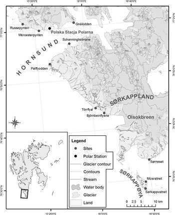
In 1982–1987, a Polish archaeological expedition from Jagiellonian University excavated the remains of Pomor hunting stations in the Sørkappland and Hornsund fjord areas. The research assessed the relics of three stations (Chochorowski Reference Chochorowski1988, Reference Chochorowski1989b)—Bjørnbeinflyene, Palffyodden, and Schönningholmane—as well as the remains of a landing place used by the Pomors on the coast of Tørrflya (Figure 1).
Map showing the location of Pomor hunting stations south of the Hornsund fjord on Spitzbergen Island investigated by the archaeological expedition from Jagiellonian University.

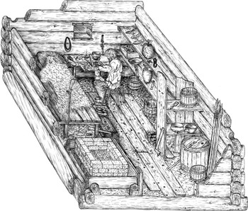
In Bjørnbeinflyene, on a high (11 m asl) promontory inaccessible from the sea, relics of a hut were discovered, built of material of very diversified origins. The ground beams were massive logs, perhaps taken from drift material at the shore (Figure 2). It was only on them that carefully hewn soleplate beams were laid, which were obviously “prefabricates” brought from the continent. The hut’s floor was made from the deck planks of a wrecked ship. Close to the hut there also were relics of a monumental cross, with a grave in a stone setting at its base. The discovery of a kaolinite pipe helped identify 1770–1810 as the time period when the hut was used (Chochorowski Reference Chochorowski1988).
Bjørnbeinflyene: reconstruction of the inside of a hut

On a nearby section of the Tørrflya coast, running to the northwest, the traces of a landing place were identified, along with pieces of a damaged boat (frames, clamps, deck planks, hull planks) typical of Pomor shipbuilding. The landing place must have been used by Pomor hunters and sailors operating from a nearby station in Bjørnbeinflyene, as the direct access to the latter was impeded by numerous skerries and shoals.
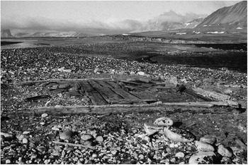
The relics of the Pomor station on Palffyodden on the southern side of the Hornsund mouth are more complex. They consist of the ruins of three huts, of which one (A) was built on an old berm crest 6 m high, and two (B, C) on a lower, 3-m-high terrace. Nearby, a small cemetery consisting of five graves covered with stone pavements was found. The ground beams of hut A were carefully worked, prefabricated beams. The floor was made from planks undoubtedly originating from a shipwreck (Figure 3). A fragment of a kaolinite pipe stem found in the ruins suggests the hut was used around 1720 (Chochorowski Reference Chochorowski1988). Hut B was built entirely from driftwood. Its layout and constructional solutions make it similar to the Bjørnbeinflyene hut (Chochorowski Reference Chochorowski1989b). All that survived from hut C were the remains of stones originally facing the ground beams. The finds of kaolinite pipe fragments date the time when the structure was used to around mid-18th century (1750–1760) (Chochorowski Reference Chochorowski1988). The relics of hut B were the best preserved of the entire Palffyodden complex, which suggest their youngest chronological position. All evidence indicates that the huts in Palffyodden were not built and occupied at the same time. Each represents a different architectural type and reveals a different intensity of occupation. Thus, they most likely were built in succession, perhaps because a certain tradition developed of returning to the place that was convenient from the point of view of hunting strategies.
Palffyodden, Hut A

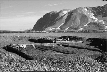
The Pomor station in Schönningholmane also has a complex structure. It also comprises three buildings, of which two (huts B and C, Figure 4) were built close to each other while the third one (hut A) is approximately 80 m to the west (Chochorowski 1989). All the huts were erected from carefully prepared beams (prefabricates) sealed with moss. Even in the floors, no secondarily used elements were recorded. Hut B stands out for its dimensions. It was surely intended as a base for a large group of hunters (known in Russian as an artel). The nearby hut C provided with a stone stove must have originally played the role of a bath (bania). It was only later that a smaller room was added to it and the function was probably changed to a dwelling. Hut A was most likely the house of the skipper (kormshchik) who directed the entire enterprise. The results of the exploration allowed for a hypothesis to be formulated that all three buildings were erected within the same period and originally formed a functionally related complex.
Schönningholmane: hut B in the first plan, with hut C behind it

On a hill (37.6 m asl) situated above the station ruins, which offered a view of the entire surrounding area, a shaft of a monumental cross was found, set in the ground and reinforced with a stone mound. Its arms were found in a deep ravine, approximately 80–90 m to the northwest from the shaft. The cross was most likely erected after the artel of hunters had landed and the decision to found the station had been made, as a symbolic sacralization of the place and a votive offering for the success of the enterprise. From the chronological perspective, it no doubt marks the terminus post quem for building the station. There can be little doubt that the Schönningholmane station was built for the entire artel and adapted to suit the needs of a winter stay. Only after the station had been abandoned (or burnt down) was its best preserved building adapted as a dwelling, this time for a small group or even a single hunter.
MATERIAL AND METHODS
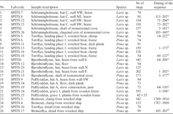
The subject of the current research is the archaeological timber originating from wooden buildings, relics of monumental crosses, and the wreck of a boat (Table 1). Twenty-six samples were selected for the analysis, which represent the most important groups of construction material used in Pomor stations, namely:
-
∙ Constructional elements of dwellings, appearing to be prefabricates brought from the continent (samples SPITS7-9, 19, 21-23);
-
∙ “Raw” driftwood, most likely collected locally (samples SPITS1, 20);
-
∙ Elements of monumental votive crosses, probably also brought from the continent (samples SPITS2, 15, 26);
-
∙ Planks from a wooden frame of grave 1 in Palffyodden (samples SPITS24, 25);
-
∙ Construction elements of ships (deck planks), secondarily used in hut construction (samples SPITS12, 14);
-
∙ Construction elements of a wrecked boat (small ship?) from Tørrflya (samples SPITS5-6, 11, 13, 16, 18); and
-
∙ Shipwreck timbers found on the shore (samples SPITS3-4, 10, 17).
Dendrochronologically analyzed samples of timber from the Pomor hunting stations.

* Relative dating against floating chronology SPITS_A3.
# Relative dating against floating chronology SPITS_B1.
The dendrochronological analysis followed standard research procedures (Schweingruber Reference Schweingruber1989). Prior to the measurements, two to four measurement paths 2–3 cm wide were cut off along radii using a preparation knife. Subsequently, for each of the samples prepared in this way, the annual growth width was measured with 0.01-mm accuracy, using a Dendrolab 1.0 apparatus (Zielski and Krąpiec Reference Zielski and Krąpiec2004). Measurements of annual growth sequences were recorded and analyzed using TREE-RINGS (Krawczyk and Krąpiec Reference Krawczyk and Krąpiec1995) and TSAP software (Rinn Reference Rinn2005). The similarity of dendrochronological sequences was assessed by means of the coefficient of parallel run (Gl) and the t coefficient (Eckstein and Bauch Reference Eckstein and Bauch1969; Baillie and Pilcher Reference Baillie and Pilcher1973). For visual assessment of the dendrograms’ similarity, logarithmically transformed raw curves were used.
In the next stage of the analysis, the correctness of the measurements and the cross-dating quality were verified using COFECHA software (Holmes Reference Holmes1983), which allows for an efficient identification of missing rings and measurement errors. The best-correlated individual sequences were used to develop the chronology with TSAP software. Standardization of dendrochronological sequences and development of standardized chronologies were performed with the ARSTAN-4.1d computer program (Cook and Krusic Reference Cook and Krusic2005).
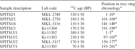
Radiocarbon dating by liquid scintillation was carried out in the Laboratory of the Institute of Environmental Geochemistry National Academy of Sciences of Ukraine in Kiev (Ukraine) and the Laboratory of Absolute Dating in Kraków (Poland). Age determinations were made for six wood samples (properly selected sequences of tree rings) whose relative chronology was established dendrochronologically. The wood underwent initial preparation with the acid-alkali-acid (AAA) method. Next, benzene was synthesized from a carbonized wood sample (Skripkin and Kovalyukh Reference Skripkin and Kovalyukh1994). The 14C concentration was measured using the liquid scintillation counting (LSC) method, using Quantulus 1220 and Hidex300SL spectrometers (Krapiec and Walanus Reference Krapiec and Walanus2011). The results are shown in Table 2.
Sample description and conventional ages.

a Position of tree rings in chronology SPITS_A3 (*) and SPITS_B1 (#), used in the wiggle-matching analysis.
Since the absolute age of wood relatively dated with the dendrochronological method had to be determined independently, the wiggle-matching method was applied. The wiggle-matching technique, together with its mathematical assumptions, is described by Bronk Ramsey et al. (Reference Bronk Ramsey, van der Plicht and Weninger2001). Wiggle-matching analysis was performed with the program OxCal v 4.2.2 (Bronk Ramsey Reference Bronk Ramsey2009) and the calibration curve IntCal13 (Reimer et al. Reference Reimer, Bard, Bayliss, Beck, Blackwell, Bronk Ramsey, Buck, Cheng, Edwards, Friedrich, Grootes, Guilderson, Haflidason, Hajdas, Hatté, Heaton, Hoffmann, Hogg, Hughen, Kaiser, Kromer, Manning, Niu, Reimer, Richards, Scott, Southon, Staff, Turney and van der Plicht2013). The D_Sequence model of OxCal with defined gaps was employed to account for almost the final tree rings of the pine and larch chronologies. The gap was a precisely known interval between the center of the relatively dated tree-ring series submitted for 14C dating. The best match between the calibration curve and tree-ring data was calculated using the agreement index A, which indicates the extent to which the posterior distribution overlaps with the individual 14C distributions in a similar way as the χ2 test (Bronk Ramsey et al. Reference Bronk Ramsey, van der Plicht and Weninger2001).
RESULTS AND DISCUSSION
The results of the dendrochronological analysis of 26 wood samples representing nearly all possible categories of construction material including shipwreck elements indicate that the wood is also diversified in terms of species (Table 1). The samples include the wood of coniferous trees only, but belonging to three different species: larch; Larix sp. (13 pieces), pine; Pinus sp. (11 pieces); and spruce, Picea sp. (2 pieces). The most popular construction wood was larch, which predominates among the prefabricates brought from the continent. The majority of the analyzed samples (64%) revealed long sequences of more than 90 rings, while 20% represented long-lived trees over 150 yr old.
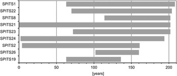
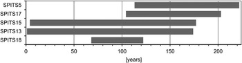
Correlations using the computer programs and visual comparisons of dendrograms made it possible to identify identical age sequences among particular types of samples. This provided the basis for developing the following chronologies: SPITS_A3 (larch, 9 samples, 208 yr, Figure 5); SPITS_B1 (pine, 5 samples, 222 yr, Figure 6); and SPITS_C1 (spruce, 2 samples, 142 yr). They were compared with the available standard curves both for driftwood and north Russian wood (Eggertson Reference Eggertsson1994a, Reference Eggertsson1994b; Hellmann et al. Reference Hellmann, Tegel, Eggertsson, Schweingruber, Blanchette, Kirdyanov, Gärtner and Büntgen2013, Reference Hellmann, Tegel, Kirdyanov, Eggertsson, Esper, Agafonov, Nikolaev, Knorre, Myglan, Churakova (Sidorova), Schweingruber, Nievergelt, Verstege and Büntgen2015, Reference Hellmann, Agafonov, Churakova (Sidorova), Düthorn, Eggertsson, Esper, Kirdyanov, Knorre, Moiseev, Myglan, Nikolaev, Reinig, Schweingruber, Solomina, Tegel and Büntgen2016). The absolute chronology was established only for the spruce sequence, thanks to its correlation with the chronology of driftwood from Isfjorden (t=7), developed by Ó Eggertsson and dated based on the chronological data from the Archangelsk region (Ó Eggertsson, personal communication, 2015). It spans the period of AD 1769–1910. Regrettably, after the death of Dr N Chernykh, the dendrochronological sequences of wood samples originating from Russian excavations in Spitsbergen, as well as the materials on which they were based, became inaccessible.
Correlation block diagram of the dendrochronological sequences forming the larch chronology SPITS_A3.

Correlation block diagram of the dendrochronological sequences forming the pine chronology SPITS_B1.

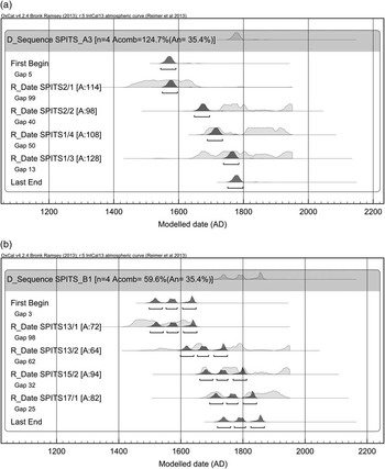
In this situation, the absolute dating of the analyzed larch and pine sequences becomes an important issue. Since their dating could not be established based on the available absolute chronologies, the only chance for determining their chronological position at least approximately was the wiggle-matching method. The samples selected for 14C analyses from the larch sequence (SPITS_A3) included one from a beam SPITS 1 (soleplate beam from Bjørnbeinflyene) and two from SPITS 2 (the shaft of the cross), covering 10 tree rings each, with the middle of their ranges falling in the years 6, 105, and 195 of the sequence, respectively (Table 2). The results (Figure 7A) suggest that the youngest rings of the larch sequence cannot be older than about AD 1751, and their most probable timespan is the second half of the 18th and possibly the 19th century. Taking into account that the samples originated from the hut in Bjørnbeinflyene (archaeologically dated to 1770–1810) and the cross from the contemporary Schönningholmane station, but ~43 yr older than the station (see Table 1), the chronological proximity of the results seems very significant. An analogical procedure was performed for the pine chronology (SPITS_B1). Three intervals of tree rings were selected from samples SPITS 13 (the frame of the wrecked boat from Tørrflya) and SPITS 17 (shipwreck element–driftwood from Breinesflya). Their midpoints fall at years 3, 101, and 197 of the entire SPITS_B1 sequence, respectively (Table 2). The wiggle-matching results (Figure 7B) show that the youngest rings of the pine sequence date from AD 1718–1760 (31.1% probability), 1772–1808 (31.7%), or 1825–1869 (32.6%). Given the archaeological and historical evidence for Pomor sailing activity in this region, the first of the above ranges seems more likely not just in statistical terms. This also corroborates the assumption that the traces of Pomor activity in Tørrflya and nearby Breinesflya are most likely linked with the episode of construction of the hunting hut in Bjørnbeinflyene (1770–1810). A general conclusion that emerges from all the results presented above is that the oldest age estimations do not reach earlier than the 17th/18th century transition and the first half of the 19th century.
14C wiggle-matching of the floating chronologies: (A) SPITS_A3 and (B) SPITS_B1

The synchronization of results obtained for wood from the analyzed features (huts, crosses, shipwreck) fully confirms the reliability of conclusions drawn on the basis of archaeological evidence (tobacco pipes in particular). The relics of Russian hunting stations in the northern part of Sørkappland, confined by the Olsok glacier (Olsokbreen) from the south and Hornsund from the north, are the remains of a functionally autonomous organization, whose genesis and historical development are marked by intrinsic logic and rationality of operations. In the initial stage of their activity, Pomor sailors and hunters penetrating the inshore fisheries of southern Spitsbergen chose the Palffyodden promontory at the southern mouth of the Hornsund fjord, protruding into the sea and easily distinguishable by the conical shape of Hohenlohefjellet (614 m asl), as the base for their operations. Dotted with skerries, rocky islands. and promontories, but also providing sheltered beaches in small bays, the Palffyodden region most likely abounded in walrus. It was also the place crossed by the polar bear paths, although it did not provide safe anchorage. At some point near the beginning of the 18th century (around 1720), the first hut was probably built in Palffyodden, which was actually not particularly conveniently as it is situated in a place exposed to strong winds blowing both from the fjord and the sea. However, due to its strategic position, Palffyodden remained a convenient starting point for subsequent generations of hunters in their penetration of the hunting grounds along the coast, both towards the fjord and to the south to the barrier of the Olsok glacier. This is why a succession of huts was built in that place (hut C in ~1750–1760; hut B in late 18th century?), which were better adjusted to the landscape and protected from harsh environmental conditions. The permanence of the operations is symbolized by the small cemetery established near the station buildings. In the last decades of the 18th century, the intensification of hunting operations and accumulation of knowledge about topography and sailing conditions in this part of Sørkappland resulted in the founding of a new station in Schönningholmene by the Pomors, arguably in the best place possible, near a safe anchorage. The station was large and was built in a single episode as a base station for an organized group (artel) of hunters. Its satellite posts, allowing the range of hunting operations to be extended, were probably the youngest building in Palffyodden and the small hut in Bjørnbeinflyene, built deliberately on the southern fringes of the hunting area. The entire enterprise was not only carefully planned and realized with a flourish, but also sacrally sanctioned in line with the norms characteristic of the religious mentality (Orthodox) of the Pomors. It is quite likely that the final episodes of Russian promysl in the discussed area, dated previously to the first quarter of the 19th century (?), had the form of operations carried out by small groups or individual hunters who used single huts that were still suitable for winter habitation (e.g. Bjørnbeinflyene, hut C in Schönningholmene, or hut B in Palffyodden). Thus, the picture of the Russian promysl development in the northern part of Sørkappland, which emerges from the synchronization of dendrochronological analysis and absolute dating of the relics of wooden constructions, is generally consistent with the chronological frameworks established for this phenomenon based on historical data (Jasinski Reference Jasinski1993; Hultgreen Reference Hultgreen2000), whereas new findings from the samples collected herein do not support the hypothesis positing a pre-Barents chronology of Russian promysl in this area.
ACKNOWLEDGMENTS
This study was supported by Institute of Archaeology of Jagiellonian University in Kraków and partly by the Faculty of Geology, Geophysics and Environmental Protection, AGH–University of Science and Technology in Kraków (project no 11.11.140.173). The authors would like to thank Dr E Szychowska-Krąpiec for her help in measuring the dendrochronological sequences.