Introduction
Maps are crucial instruments for defining a region and affecting popular perceptions and understandings of its geographic, social, and political shape. In the northern polar region, mapmaking processes have been especially important for articulating the extent of the Arctic. From the efforts of European explorers between the sixteenth and nineteenth centuries to find the northwest passage to modern-day bathymetric charting of the Arctic Ocean seafloor, mapping the Arctic remains an important pursuit for the eight countries with territorial claims north of the Arctic Circle, along with the many countries south of 66°33’N that possess northern interests.
A rich body of literature has deconstructed Canada's historical attempts to define its ‘North’ or ‘Arctic’ region (for example Grace Reference Grace2002; Wonders Reference Wonders2003). In his essay, ‘The North in Canadian History’, mid-century Manitoba politician William Morton (Reference Morton1960) declared that Canada was unlike the United States, for ‘what makes the difference is the North, the fact that Canada is a northern country, with a northern economy, a northern way of life, and a northern destiny’ (Reference Morton1960: 26). The north is integral to Canada's identity and to its future, but defining what is included within it has long challenged the federation. Quebecois geographer Louis-Edmond Hamelin introduced the concept of ‘nordicity’ to quantify a place's degree of northerness based on ten ‘polar values’, variables ranging from latitude to degree of economy activity (Hamelin Reference Hamelin and Barr1979). Despite such attempts at quantification, Grace avers, ‘North is an idea as much as any physical region that can be mapped and measured for nordicity’ (2002: xii). But in fact the north constitutes multiple ideas. As we attempt to show in this paper, different groups possess different conceptions of the region.
Since the 2000s, ideas about the Arctic have been shifting domestically and internationally, driven by the melting of polar ice and the global commodities boom, among other factors. Many Arctic countries’ northern regions have moved closer to the centre of their domestic and foreign policy strategies (Heininen Reference Heininen and Heininen2012), while areas just on their fringes have become marginalised as liminal spaces neither included within the newly (re)defined ‘Arctic’ nor in the southern metropolitan heartland. In Canada, former Prime Minister Stephen Harper aggressively promoted Canadian sovereignty over its Arctic, the region's economic value, and the importance of the north to Canadian national identity (Dodds Reference Dodds2011). Given these developments, it is worth reassessing how the Canadian north is articulated in the contemporary era. We argue that insufficient attention is paid to the ways in which the Arctic is defined domestically within each country, hampering understanding of how region-building processes have impact on communities and individuals as well as inter-state Arctic relations. This topic is also worthy of reflection because domestic perceptions also affect international definitions of the Arctic. For instance, pressure from indigenous groups forced the government of Canada to include Nunavik and Nunatsiavut (the Inuit homelands in northern Quebec and Newfoundland and Labrador, respectively) in regional maps for the Arctic Monitoring and Assessment Programme and the Arctic Human Development Report (Arctic Reference CouncilCouncil n.d.), even though Canada does not officially recognise either of these more extensive spatial definitions of the Canadian Arctic within its own northern policy. This discrepancy may speak to Canada's perception of itself as a leader when it comes to Arctic foreign policy, which contrasts with its status as a ‘laggard’ in domestic Arctic policy (Keskitalo Reference Keskitalo2004).
In contrast to much of the recent work that interrogates how the five littoral countries around the Arctic Ocean (Canada, Greenland (Denmark), Norway, Russia, the United States and arguably Iceland), delimit the international borders of their Arctic regions in relation to one another (Blunden Reference Blunden2009; Dodds Reference Dodds2010; Gerhardt and others Reference Gerhardt, Steinberg and Tasch2010), we elucidate the process through which the contemporary Canadian Arctic is defined through many and competing cartographic practices and by different organisations. We pay special attention to maps produced by representatives of Inuit in Canada who put forth a vision of an Inuit homeland, Inuit Nunangat, that differs significantly from the state-defined Canadian north. Though outside the scope of this paper, it is worth noting that competing definitions of the north affect more than just Inuit. Aboriginal peoples, some of whom live within the state-defined north and some beyond, experience these same divisions, too, as do non-aboriginal northerners.
Rather than considering state-centric geopolitics, our approach shifts questions about Arctic mapmaking and policy to the scale of the individuals inhabiting the Arctic. Here, decisions about how government defines the Arctic region have tangible impacts on people living both inside and outside the state-defined space. The mapmaking efforts and policies that materialise due to disparities between state and local inhabitants’ definitions of the Arctic create bifurcated communities, with those living outside the state-defined Arctic, we argue, being marginalised due to their exclusion from federal programmes, state subsidies for northern residents, and conceptual belonging as northerners.
We begin this paper by tracing the role of Inuit and western knowledge in mapping the Arctic. We then examine three case studies to question how the Arctic is defined and mapped within Canada. We review, in the following order: a state-oriented map produced by the federal government as part of its Northern Strategy (2009) policy document; a resource-oriented map produced by the federally-funded Geo-Mapping for Energy and Materials (GEM) programme; and two recent indigenous-oriented maps produced by Inuit Tapiriit Kanatami (ITK), the national organisation representing Inuit in Canada. Drawing on Rundstrom (Reference Rundstrom1990), for these three case studies we perform an institutional analysis to help explain how the values associated with different institutions are presented in maps. Our approach is novel in that we attempt to show that while the process of making an individual map is a finite process, articulating a region is an iterative process that occurs partly through a ‘cartographic conversation’ in which maps enter the public sphere, and the world views that inform them are taken up, consciously or not, in the creation of other maps.
In the discussion, we elaborate on how the differences in cartographic articulations of the Canadian Arctic between state and indigenous maps have substantive implications for policy, particularly in terms of land use and access to certain Arctic-specific federal funds. In this section, we also investigate how the four maps ‘speak’ to each other in order to highlight differences in state- versus indigenous-led mapmaking efforts. First, we show how ITK has adopted western cartographic thinking and conceptions of space and territory, and second, we explore how what is left out is just as revealing of a mapmaker's agenda as what is displayed, be it communities, environments such as sea ice, or other countries. We thus illustrate that the definition of the Arctic as a region is predicated on deliberate erasures and omissions. To conclude, we reflect upon how the Northern Strategy, GEM, and ITK maps demonstrate that articulating the extent of the Canadian Arctic remains a continuing and contested process.
Inuit and western mapping in the Canadian Arctic
Cartographic mapping is a vital part of constructing the Arctic region. This is especially the case because, as the Arctic Human Development Report notes, ‘there is nothing intuitively obvious about the idea of treating the Arctic as a distinct region . . . It is possible to resort to the use of biophysical criteria to determine the extent of the Arctic as a region . . . [but] this approach has little to recommend it in cultural, economic, or political terms, [and] it also fails to produce a clear cut result’ (Young and Einarsson Reference Young and Einarsson2004: 17–18). Mapping, as many acknowledge, is thus clearly subjective (Harley Reference Harley, Cosgrove and Daniels1988, Reference Harley1989; Monmonier Reference Monmonier1991; Edney Reference Edney1993; Crampton Reference Crampton2011). Maps are cartographic artefacts that represent specific worldviews and spatial ontologies (Mundy Reference Mundy2000). Rundstrom (Reference Rundstrom1990: 155) claims that, when put to paper, maps resulting from different interests and ways of thinking ‘reflect and reinforce the world view or spatial thought of a culture’. Certainly, when a single spatial ontology takes hold within the public domain as the accepted definition of a region, this can extinguish other spatial images. However culture's representations of space can coincide and influence each other too.
Since the first contact between Inuit and European explorers in the Canadian Arctic, indigenous modes of spatial thought have rarely developed in isolation from western ways of thinking about visualising space. Still, while the mapmaking processes of Arctic indigenous peoples have been explored, especially within Canada (for example, Spink and Moodie Reference Spink and Moodie1972; Rundstrom Reference Rundstrom1990; Okladnikova Reference Okladnikova, Woodward and Lewis1998; Aporta Reference Aporta2009; Tobias Reference Tobias2009), they have rarely been put into contrast with maps made by states and other organisations, which are usually considered independently. Though Inuit conceptions of geography were historically distinct from European spatial ontologies (Aporta Reference Aporta2009), modern Inuit maps such as those discussed below indicate apparent shifts in Inuit spatial thought, dividing Inuit Nunangat using settler-colonial Canadian boundaries rather than relying on traditional Inuit ways of seeing the north.
Whereas today's ITK maps adopt western mapmaking practices, the flow of cartographic knowledge was previously reversed, with Inuit often assisting European explorers in their navigational endeavours. Rundstrom (Reference Rundstrom1990: 159) explains how the accuracy of Inuit maps constantly ‘astonished’ British and Danish mariners, geologists, and explorers. Indigenous knowledge, though often provided voluntarily, was later used to support the expansion of western imperial and colonial interests, enabling dispossession of traditional Inuit territories by the Canadian state. In the post-World War II period, indigenous lands in Alaska and Canada were accurately mapped, often by military bodies, in order for the state to secure land tenure and establish control over access to natural resources (Chapin and others Reference Chapin, Lamb and Threlkeld2005).
By the 1980s and 1990s, the Canadian state's military interests in the Arctic were secure (though reduced compared to their Cold War's height), but perhaps as important was the material and cartographic reorganisation of the region according to Western concepts of permanent settlement, and private property. Price and Cooper (Reference Price and Cooper2007:116) argue that ‘maps have power because there is a tendency by map readers to equate territorial representation with ownership’. Mapping is a practice that, especially when carried out by the state, supports its structuring of a physical space (Sikor and Lund Reference Sikor and Lund2009). Consequently, the dominance of Western cartographic practices in delineating and visualising the Canadian Arctic as a region based on features such as straight baselines, continental shelves, and the 60th parallel rather than a networked and interconnected area based on indigenous use means that map readers may first think of the Canadian Arctic as the state's northern frontier rather than as an Inuit homeland. Whereas Aporta (Reference Aporta2009) has shown that the Inuit in Nunavut conceive of their northern homeland as a network of trails connecting communities, fishing lakes, and hunting grounds, Canadian state-produced maps tend to emphasise the region's physical geography and natural resources while showing only a handful of isolated settlements. Such people-less portrayals convey a decidedly different narrative for ongoing or potential land use in the region and conceivably make it easier to build public support for industrial activities like hydrocarbon extraction and trans-Arctic shipping.
While state-of-the-art mapping practices dominate current cartographic practices in the Arctic, new representations of Inuit ways of seeing space have entered the public debate. One example is the Igliniit project, which merges Inuit traditional knowledge with new technology to track Inuit travel routes across sea ice (Gearheard and others Reference Gearheard, Aporta and Aipellee2011). A second is the interactive online atlas of Pan-Inuit Trails (http://www.paninuittrails.org), which visualises Inuit mobility and occupancy in the Canadian Arctic. Such projects could be considered forms of ‘counter-mapping’, a term used for the practice of mapping against dominant power structures (Peluso Reference Peluso1995). Poole (Reference Poole1995) advocates the potential of counter-mapping to enable greater protection of indigenous land rights and management of resources, among other things. In this context, Inuit creation of their own maps of the Arctic, or the simple attachment of Inuktitut place names to locations they know and inhabit, allows them to assert claims over the region as they perceive politically, geographically, and socially appropriate. As remarked in a document by Qikiqtani Inuit Association (2012: 14) on Inuit participation in managing Lancaster Sound: ‘Maps are one of the most important tools to collect Inuit Qaujimajatuqangit [Inuit knowledge] and make it available for direct and sustained participation of Inuit in the integrated planning of the Lancaster Sound [National Marine Conservation Area]’.
In reflecting power relationships and constructing boundaries, maps define territory with critical implications for identity and difference (Wastl-Walter and Staeheli Reference Wastl–Walter, Staeheli, Staeheli, Kofman and Peake2004). This is not to say that southern scientists and policymakers never work with indigenous peoples or engage with indigenous knowledge, but rather to point out that their epistemologies often triumph when it comes to presenting a region cartographically. The cartographies of maps issued by national governments and scientific agencies can have implications beyond just defining where the Arctic is; indeed, they affect the investments and subsidies that support northern communities and can even unite or divide entire groups of people, depending on where boundary lines are drawn. Far from the unified, pristine expanse that it may appear as when seen from outside, the Canadian north, in particular, is continually driven by conflicts at the national level over where to draw the domestic border between north and south.
Reading between the maps
Case study 1. A government's view of the north
At least since the 1950s, the Government of Canada has attempted to integrate its northern regions into the nation and encourage the idea of a ‘Northern homeland’ (Tester and Kulchyski Reference Tester and Kulchyski1994). Paradoxically, however, the federal government routinely defines the North as a region apart from the rest of Canada. In step with increased global interest in the Arctic and the release of policy documents in other northern states regarding their Arctic regions (Heininen Reference Heininen and Heininen2012), the federal government published its own Arctic policy in 2009, entitled Canada's Northern Strategy (Canada 2009). Since its purpose was to provide an overarching framework for all areas of federal Arctic policy, the Northern Strategy's depiction of the Arctic may be interpreted as authoritative – though not the sole representation of how the decade-long Harper government conceived of the region with a spatial definition that has generated definite consequences for the people living within and outside its bounds.
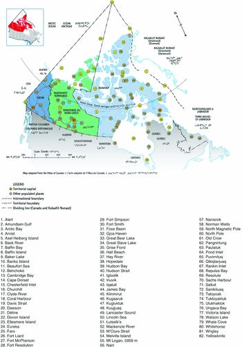
The government of Canada inconsistently defines the territorial extent of its Arctic region; over time and across departments, documents, and maps, the geographic and social boundaries of Canada's Arctic fluctuate. The principal map provided in the Northern Strategy (Fig. 1) identifies ‘Canada's north’ as congruent with the three federal territories of Yukon, Northwest Territories, and Nunavut, even though seven communities located in the northern regions of three different provinces are listed on the map and in the index of ‘populated places’. This may represent a pragmatic effort to include communities that would typically be defined as socially and ecologically ‘Arctic’ while avoiding the inclusion of land area under provincial jurisdiction. Yet, at the same time, it puts these populations into a state of ‘peripheral Arcticness,’ with little legal or political clarity regarding their potential northern status, as they remain officially outside the three territories that constitute the state's view of the north's extent. Maps, documents, and websites related to the Northern Strategy repeatedly emphasise the three territories in depictions of ‘the Arctic’ or ‘the north.’ Similarly, the government's list of achievements under the Northern Strategy highlights numerous federal-territorial programmes and agreements while omitting any programming or policy achievements outside the territories (Canada 2011). In sum, while there are inconsistencies in the government's own definition, the federal government principally defines the Arctic in terms of the three territories.
Map of Canada's North. Source: Canada's Northern Strategy (2009).

The lines delineating the international limits of the Canadian Arctic are also drawn on a political, rather than legal or geographical, basis. In Canadian legal terms, ‘international boundary’ refers to national borders as determined by the International Boundary Commission, but in the Northern Strategy map, the term also refers to the Exclusive Economic Zone (EEZ) and prospective limits of the extended continental shelf. Extending all the way to the North Pole, the area on the map enclosed by ‘international boundaries’ is actually larger than the present EEZ afforded to Canada under international law. It mirrors the ‘sector’ of the Arctic from 60°W to 141°W, first proposed as Canadian in 1907, claimed by Canada in 1925, formalised by the Imperial Privy Council in 1927, and abandoned by Prime Minister Harper in 2006. Since the sector principle was never recognised under international law, the map enshrines as cartographic fact a political claim of dubious legal standing (Byers Reference Byers2009: 43–44). The map also divides the waters contained within Canada's supposed ‘sector’ of the Arctic Ocean between Nunavut and the Northwest Territories, but not between Yukon and the Northwest Territories. Thus, not only does the map lay claim to waters not officially recognised as Canadian, it also arbitrarily apportions these between only two of its three territories, despite the fact that blue marine areas in the north fall under federal, not territorial, jurisdiction (Becklumb Reference Becklumb2013).
Similarly, the western maritime boundary in the Beaufort Sea is drawn as a prolongation of the terrestrial border between Alaska and Yukon, reflecting the government's position in the continuing boundary dispute with the United States. In the east, however, Canada is not represented as having an ‘international boundary’ but rather a ‘dividing line’ with what the map labels Kalaallit Nunaat (instead of the more conventional ‘Greenland’). This line is drawn all the way to the North Pole, representing the boundary established between the two countries in 1973 ‘on the basis of the equidistance principle from straight baselines created along the coastlines of Greenland and of Canada’ (Office of the Geographer 1976: 5). However, the ‘dividing line’ changes into an ‘international boundary’ north of Greenland as it passes through the Lincoln Sea, suggesting that the Canadian government views this potentially resource-rich marine area as its sovereign territory. This is even more puzzling given that the only disputed land territory in the entire circumpolar region is Hans Island, located in the middle of the Nares Strait between Canada's Ellesmere Island and Greenland. Thus, the Northern Strategy map clearly stakes Canadian claims to contested Arctic territory in some areas while demonstrating a surprisingly vague commitment on the subjects of international separation between Canada and Greenland and sovereignty over Hans Island, which is also not listed in the index of Arctic locations.
While principles such as straight baselines, sectoral lines, equidistance, and political boundaries between territories and provinces inform delimitation of the western Canadian Arctic and Arctic Archipelago, in the eastern Arctic the Northern Strategy map illustrates that geography, particularly water, is a significant determinant of boundaries. In addition to the provincial status of Quebec and Labrador, in the eyes of government cartographers their separation from Nunavut by Hudson Strait (Nuvummiut Tariunga) justifies their exclusion from the Arctic. This division speaks to categorical differences between the Government of Canada and Inuit in their conception of terrain. Whereas western understandings tend to view water as a material that divides, for Inuit who have long navigated the many waterways in their environment (Arima Reference Arima1994), limiting the Arctic's southern extent to the Hudson Strait is counterintuitive. Müller-Wille (Reference Müller–Wille1989: 20) finds that ‘Inuit consider this area - coast and offshore - as one within the bounds of Nunavik as represented by their contiguous Inuit place name system’.
The Northern Strategy map clearly demonstrates the dominance of settler geographies over those of indigenous peoples. While Canada's Arctic sovereignty rests in part on Inuit use and occupancy (Canada 2009), the Northern Strategy map minimally reflects Inuit spatial ontologies. Indeed, the map represents a bifurcated landscape of water and land contrary to the Inuit view of their relationship as an integrated whole (Aporta Reference Aporta2009). In this respect, the map (re)inscribes the Arctic in terms of southern Canadian values and interests and from the perspective of Canadian sovereignty. Curiously, the omission of Inuit perspectives serves to undermine Inuit sovereignty as a self-determining indigenous people while also potentially weakening Canada's own Arctic sovereignty claims. The federal government has used the prior occupation of Inuit to support its Arctic sovereignty claims since at least 1985, when Secretary of State for External Affairs Joe Clark told the House of Commons: ‘Canada's sovereignty in the Arctic is indivisible. It embraces land, sea and ice . . . From time immemorial Canada's Inuit people have used and occupied the ice as they have used and occupied the land’ (quoted in Byers Reference Byers2009: 53). Some analysts have wondered why the federal government has not explicitly marshalled Inuit sovereignty to support its own assertion of Canadian sovereignty with respect to the northwest passage (Fenge Reference Fenge2008, Reference Fenge and Nickels2013; Mifflin Reference Mifflin2008; Byers Reference Byers2009). Instead, the Northern Strategy map omits Canadian Inuit polities entirely, denying them recognition as constituent political units of the Canadian north. However, the use of a ‘dividing line’ rather than an ‘international boundary’ to separate Nunavut and Greenland, as well as use of the Inuit term Kalaallit Nunaat, seem to imply the possibility of some alternative political relationship. Perhaps inadvertently, the map suggests some possible form of ‘Inuit Union’ (Ejesiak Reference Ejesiak and Nickels2013), given that the boundary between Inuit in Canada and Greenland is not depicted as a political border separating sovereign states.
This reflects a further inconsistency in the Northern Strategy map's elucidation of the transnational boundaries between Inuit inhabiting Canada, Greenland, and the United States (as well as Russia, which is not shown on this map). Inuit in Nunavut and Greenland are shown as separated by a vaguely defined ‘dividing line’, but the 141°W border that separates the Inuvialuit and Inupiat communities living in Yukon and Alaska, respectively, is clearly depicted as an international boundary separating Canadian sovereign territory from the United States. Overall, the map portrays certain geopolitical boundaries as more significant than others and certain intra-Inuit relations as more meaningful, while selectively employing contested legal concepts, political claims, and indigenous sovereignty in ways that are both confused and, quite possibly, counter-productive to the execution of Canada's Arctic policy objectives.
Case study 2: Geo-mapping for energy and minerals- but not people
The second case study analyses a map produced by Natural Resources Canada's (NRCan) Geo-mapping for energy and minerals (GEM) programme. Established in 2008, GEM is described by the Northern Strategy as ‘a significant new geo-mapping effort . . . that will combine the latest technology and geoscientific analysis methods to build our understanding of the geology of Canada's north, including in the Canadian Arctic Archipelago’ (Canada 2009: 16). GEM was a cornerstone of the Conservative government's economic vision for the Canadian north, which prioritises non-renewable natural resource extraction, private sector involvement in northern governance, and commercialisation of Arctic science and research (Aglukkaq Reference Aglukkaq2012). While the programme reflects top-down, government-initiated science, it also has an Advisory Group of Northerners that includes ‘representatives from territorial governments, the private sector and aboriginal socio-economic development organisations’ (NRCan 2015). The first phase of GEM lasted from 2008–2013, and the programme was renewed until 2020 with a further CAD$100 million. GEM can be seen as a realisation of NRCan's (2015) stated commitment to ‘helping unlock the full mineral and energy potential of the North and to promoting responsible land development in the region’.
Before it becomes possible to develop Arctic resources, the federal government must first determine the boundaries of the region to be explored. GEM, which has so far created over 700 maps, builds on a long history of mapmaking for identifying and securing natural resource deposits (Vandergeest and Peluso Reference Vandergeest and Peluso1995; Vandergeest Reference Vandergeest1996), especially in Canada (Chapin and others Reference Chapin, Lamb and Threlkeld2005). When Prime Minister Harper announced GEM prior to his annual northern visit in 2008, he drew parallels with the cartographic efforts of Arctic explorers in previous centuries:
The geo-mapping project is part of a larger plan to map and chart Canada's North, to continue the bold tradition of exploration that has defined our history, and to strengthen our understanding and our sovereignty over a region that will define our future. As I've said before, use it or lose it is the first principle of Arctic sovereignty. To develop the North, we must know the North. To protect the North, we must control the North. To accomplish all our goals for the North, we must be in the North (Prime Minister of Canada 2008).
Harper's comments divulge his view that it is not enough for a state to merely claim land, especially in areas with abundant natural resources. Instead, it must transform the land from uncharted terrain into mapped and known territory to render it legible for state interests. Under the ‘use it or lose it’ sovereignty doctrine of the Harper government, Canada has been preoccupied with the notion that the state must outwardly demonstrate ownership over its Arctic territory through ‘control, surveillance, and regulation vis-à-vis markets, populations, and external agencies’ (Ong Reference Ong2000: 56). Control, surveillance, and regulation, however, cannot take place without knowing where resources of interest are located, which is where the scientific and industrial knowledge produced through mapping activities like GEM become relevant.
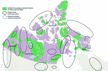
Due to the importance of GEM in realising the natural resource potential of the Canadian Arctic, which constitutes a large part of the Northern Strategy's economic and social development pillar, in this case study we focus on an overview map included in a 2012 NRCan report that depicts GEM's area of interest (Fig. 2). Though also commissioned by the Conservative government, the map depicts the Canadian north in a markedly different fashion than the one produced for the Northern Strategy. Three of the GEM map's features are particularly notable: its project zones, categorisation of areas into essentially ‘known and ‘unknown’, and diamond corridors.
GEM Project Areas. Source: GEM Coordination Office, via NRCan (2012).

First, while the coloured area in the GEM map matches the terrestrial Arctic region as defined in the Northern Strategy, the ‘project zones’ for resource exploration extend far beyond the three territories’ southern b orders. The project zones are all ovals of various sizes without reference to geographical or even political features, as if a government cartographer's hand were drawing at whim over a map of northern Canada. One project zone includes an area approaching Prince George, British Columbia, while another includes areas in the provinces of Quebec and Newfoundland and Labrador, and the Inuit region of Nunatsiavut. Other project zones are depicted entirely within the provinces of Saskatchewan and Manitoba, with no overlap at all with the territories. The inclusion of significant provincial areas illustrates a fundamental distinction between the GEM and Northern Strategy maps regarding the areas considered within the scope of ‘the north’. The federal government's boundaries of the Arctic appear flexible when a looser definition supports its resource development plans, but less so when it entails including communities in the provincial north. Notably, however, the resource-rich Beaufort Sea, one of the most accessible areas in the Canadian Arctic, is omitted as a project zone even though other marine resource areas are included. This selective representation of resource areas may be due, in part, to NRCan's wish to avoid raising the question of disputed boundaries with the United States. In that sense, then, the map is not even comprehensive with respect to potential areas for resource extraction, emphasising that a large part of the stories maps tell is revealed by their exclusions, whether people, areas, or resources.
A second notable feature of the GEM map is its division of land into two categories: areas with ‘Sufficient knowledge to identify potential for resources (pre GEM)’ and areas without. The report in which the GEM map is included describes public geoscience knowledge and geological knowledge as the information necessary to support stable long-term resource development and for ‘investment and development decisions by the private sector and Northerners in general’ in such sectors (NRCan Reference McCannon2012). Agrawal (Reference Agrawal2002) finds that indigenous spatial ontologies are often appropriated by more powerful actors for the purposes of identifying resources, a distraction which undermines their ability to upset existing power relations. But no indigenous spatial ontologies seem to inform the GEM map. The geoscience and geological knowledge required involve data from state-of-the-art scientific methods and high-tech infrastructure, while the resources in question are limited to non-renewable commodities such as fossil fuels and minerals. Both the knowledge GEM needs and the export-oriented resources it uncovers are of a qualitatively different nature than indigenous knowledge and resources, which generally encompass the biotic resources necessary for subsistence (Wenzel Reference Wenzel2009). Together, these differences in valuation of natural resources, and by extension the different locations in which they may be found, speak to the role of historically and geographically contingent social appraisals in turning nature into resources (Castree Reference Castree1997). In the NRCan map, no maritime areas fall within the category of ‘Sufficient knowledge to identify potential for resources (pre GEM)’ even though places including Lancaster Sound, the northern part of Hudson Bay, and the eastern Beaufort Sea are deemed ‘Project zones.’ This omission underscores the Canadian government's tendencies to bifurcate water and sea areas and to depict greater confidence in its knowledge of land rather than water, which continues to complicate Western conceptions of territory. Areas for which there is sufficient knowledge, a category that visually encompasses about a quarter of the three territories, are often shaped like quadrants, suggesting the state surveyor's hand at work dividing space according to geometric principles rather than indigenous familiarity with land, sea, and ice.
Diamonds are the only natural resource specifically identified on the GEM map and are illustrated by the third feature of interest: the dashed-line ‘diamond corridors’. Minerals like gold, nickel, and uranium have attracted miners to the Canadian north since at least the late nineteenth century, but the diamond boom only began in earnest in the Northwest Territories in the 1990s following the discovery of diamonds at Lac de Gras, within the westernmost ‘diamond corridor’ on the map. The encircled diamond corridor has resulted in a literal diamond highway. This is where the world's longest heavy-haul ice road lies, supporting the area's diamond mining and exploration activities. The NWT's transformation into one of the world's major diamond producers has had significant impact on the territory's people and environment, generating not only unprecedented revenues but also negative effects ranging from mental health problems to environmental degradation (Gibson and Klinck Reference Gibson and Klinck2005). Many of these issues could play out again in the map's two proposed diamond corridors in Nunavut.
Also not represented in the map are most communities, living resources, and ice. Instead, only the three territorial capitals are featured, along with Resolute, an Inuit hamlet that has been a central focus of Harper's policies towards Arctic sovereignty. There, the Department of National Defence (DND) and NRCan are constructing a joint facility that will incorporate a new Canadian Armed Forces Training Centre, a project that requires the expansion of the existing facility housing NRCan's Polar Continental Shelf Program. DND asserts that ‘as activity in Canada's Arctic accelerates, the military will play an increasingly vital role in demonstrating a visible Canadian presence in this potentially resource-rich region’ (National Defence and the Canadian Armed Forces 2013). Ostensibly, the GEM map is intended to display potential zones of natural resource extraction. It also reveals the interdependence of science, resource extraction, sovereignty, and the military in the Canadian Arctic, which often occurs at the exclusion of northern communities.
Case study 3. Inuit Nunangat: the Arctic as homeland to Canadian Inuit
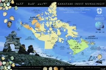
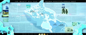
The third case study examines two maps produced by ITK. Founded in 1971, ITK ‘represents and promotes interests of Inuit on a wide variety of environmental, social, cultural, and political issues and challenges facing Inuit on the national level’ (ITK n.d.). In 2005, ITK produced a map titled Kanatami Inuit Nunalingit [Inuit communities of Canada] (Fig. 3) portraying the 53 Inuit communities located across northern Canada (ITK 2005). In addition to including individual communities, the map visualises Inuit Nunangat as comprising the four federally recognised Inuit regions: the Inuvialuit Settlement Region, Nunavut, Nunavik, and Nunatsiavut. The map's foundation thus rests on human geography and Inuit land claim agreements. Map features are presented primarily in Inuktitut (both syllabics and Roman orthography), with English and French translations taking a secondary role. ITK published a second map, Sikunga Ausuittuq Ammalu Inuit [Polar ice and Inuit] (Fig. 4), to complement ‘Inuit communities of Canada’ (ITK 2008b). While it provides names and descriptive passages for each of the four Inuit regions in English and Inuktitut, the map's principal feature is its distinction between ‘land fast ice’, ‘marginal ice’, and ‘polynyas’, all rendered in shades of icy blue and white. In contrast to the Northern Strategy map, which depicts Greenland as Kalaallit Nunaat, the ITK maps do not allude to Inuit in Greenland, Russia, Alaska, or those living elsewhere within Canada but outside Inuit Nunangat. Somewhat surprisingly, these maps thus depict Inuit in northern Canada in isolation from the transnational Inuit community and omit significant numbers of Inuit who no longer reside in the north. This omission could be interpreted as the adoption of state-centric spatial ontologies by ITK that, rather than imagine the Inuit homeland as a transnational networked area of communities spanning the Arctic and sub-Arctic, conceive of it as predicated on sovereign space bounded within the international state system. Conversely, however, Sikunga Ausuittuq Ammalu Inuit [Polar ice and Inuit] exclusively depicts sea ice and does not visualise comparable terrestrial features such as land ice, ice roads, or permafrost. On the one hand, this emphasis underscores the centrality of sea ice to Inuit identity and ways of life (Bravo Reference Bravo2009). On the other, this reproduction of a land/water binary also reflects Inuit adoption of western orderings of geographic space.
Kanatami Inuit Nunalingit (Inuit Communities of Canada). Source: Inuit Tapiriit Kanatami (2005).

Sikunga Ausuittuq Ammalu Inuit (Polar Ice and Inuit). Source: Inuit Tapiriit Kanatami (2008).

The ITK maps in Figs. 3 and 4 address two crucial omissions in the federal government's Northern Strategy. First, the ‘Inuit communities of Canada’ map (Fig. 3) depicts all four recognised Inuit land claim areas in Canada, including Nunavik in northern Quebec and Nunatsiavut in northern Labrador, which are both excluded from the Northern Strategy map. This reflects the Inuit notion of themselves as a people separated by artificial jurisdictional boundaries within Canada as well as by international boundaries between Canada, Greenland, the United States, and Russia. In parliamentary testimonies, Inuit witnesses decried the division of Inuit Nunangat and the exclusion of Inuit located within the provincial north from Canada's Arctic policy. Testimonial criticisms included explicit requests or references to past requests for the Government of Canada to reconsider its exclusion of certain Inuit on the basis of living within provinces rather than territories. For example, an executive with Makivik Corporation, which administers the Inuit land claim agreement in Nunavik, testified to the House of Commons Standing Committee on National Defence:
We are not second-class Inuit. Nunavik's exclusion from the Northern Strategy is based on artificial boundaries, not geographical or social ones. We are Inuit, just like our cousins in Nunavut, and we want the Canadian government to recognise this simple reality . . . We request that the Canadian government clearly acknowledge that the Northern Strategy applies to Nunavik to the same extent as to other regions in Canada's Arctic . . . Make it a Northern Strategy for the northern population and the geography – the people and the land. Don't exclude us just because we happen to be in the province of Quebec (Standing Committee on National Defence 2009: 7).
Despite the clear, repeated, and insistent objections of the peoples in question, the federal government has maintained its policy of defining the Arctic in a way that divides and effectively excludes some indigenous peoples. In effect, the government's definition of the Canadian Arctic through the Northern Strategy acts to silence some indigenous voices through the imposition of settler-colonial boundaries.
Second, the ‘Inuit communities of Canada’ map, particularly with its surrounding graphics and background, alludes to how Inuit Nunangat comprises land, water, and ice, as all three are integral to Inuit culture and ways of life (ITK 2008a). Sea ice is often not considered in western-oriented, political maps of the Arctic, in part because its dynamic, seasonal nature makes it difficult to include in maps based on a spatial ontology of fixed and unchanging land, such as the Northern Strategy’s. In contrast to such a static view of Earth's surface, the Inuit Circumpolar Council (ICC) (2008: 2) notes that ‘when defining our “land”, Inuit do not distinguish between the ground upon which our communities are built and the sea ice upon which we travel, hunt, and build igloos as temporary camps. Land is anywhere our feet, dog teams, or snowmobiles can take us.’ For Inuit, ‘land’ and ‘territory’ are mobile rather than fixed concepts, and consequently, the Arctic conceivably extends to wherever they travel.
Translating these concepts into maps can be challenging. However, attempting to do so, and therefore appropriately conveying the scope of Inuit Nunangat, is crucial for sociocultural and political reasons, including Inuit representation to the federal government in Ottawa and allowing Inuit to maintain or re-establish alternative economic foundations on which to secure their livelihoods. It was in order to convey these important messages that ITK published Sikunga Ausuittuq Ammalu Inuit [Polar ice and Inuit] (Fig. 4), which even more explicitly reminds us that sea- and ice-scapes are vital components of Inuit conceptions of, and well-being in, the Arctic (ITK 2008b). But, as is now well known, climate change poses exceptional threats to the character and extent of sea ice in the Arctic, which has considerable implications for Inuit and non-Inuit use of the sea and land, including subsistence, resource extraction, and shipping (ACIA 2004).
In addressing the omissions outlined above, ITK's maps contrast with the Northern Strategy and GEM maps by making Inuit in the Canadian north visible and recognisable. ITK's maps are not primarily cartographic renditions of the geographical extent of the Arctic in Canada, but rather visualisations of the Inuit homeland. The maps focus on human beings and their livelihoods, highlighting a key divergence in conceptions of the Arctic as indigenous homeland versus resource frontier. The message reiterated by ITK (2008a) echoes discussions from decades past: ‘The Arctic is not an empty, remote space waiting passively for Southern-led resource exploitation to occur; instead, it is filled with people who possess autonomy and lead distinct ways of life’.
The ITK maps reflect major institutional shifts resulting both from and in increased political decision-making abilities for Inuit in Canada, but can only be effective if bodies other than Inuit themselves accept them. To address this concern, ITK also published a document in 2008 titled An integrated Arctic-Northern strategy. ITK submitted the document to the federal government during the drafting of the Northern Strategy to ensure Inuit were involved in the formation of government policy. Significantly, it includes a call for ‘getting the geography right’ with the objective of ‘[d]ispelling confusion and defining a workable Canadian stage for Arctic-Northern policy’ (ITK 2008a). In the eyes of ITK, a workable stage for policy in the region is one that encompasses two precise geographic components: ‘an Arctic component, which can be said to be the same geographic area as Inuit Nunaat, the land and marine areas that make up the modern Inuit land claims agreements that stretch from the Beaufort Sea region to Labrador; and a north component, which can be said to be composed of the three territories’ (ITK 2008a: 11). ITK proposed the unique term ‘Arctic-North’ as a comprehensive label for the region in question that would bridge the gap between Inuit and government understandings of what constitutes the Arctic. An additional important component of the Integrated Arctic-Northern strategy concerns questions of land use and management. As Inuit regions strive to facilitate vibrant, self-sufficient northern communities able to practice their culture and traditions (for example, Nunatsiavut Government 2012), the ability to inform land use decisions is as crucial as questions over the geographic extent of the Arctic.
Maps matter: effects of colonial cartography in Northern Canada
Our comparison of maps produced by the federal government for the Northern Strategy and the GEM programme with two maps produced by ITK helps elucidate differences in how western and Inuit spatial ontologies articulate the Canadian Arctic. Whereas the priority of the Northern Strategy map is to delineate land extent, the GEM map focuses on demarcating land for the specific purpose of promoting resource extraction. The ITK maps serve as counter-narratives to the federal government's dominant paradigms of sovereignty and resource development. Yet the government's western way of defining the region with spatio-political boundaries based primarily on land rather than water or ice is clearly dominant. This dominance affects two key activities: delimiting an Arctic ‘in-group’, which has access to federal funds earmarked for the Canadian Arctic, and determining land use.
An Arctic in-group and a subaltern sub-Arctic
The federal government's definition of the Arctic excludes provincial Arctic and sub-Arctic regions from the Canadian north, separating the territories’ inhabitants from people short distances away, who might be considered near neighbours living in ecologically and socially similar circumstances. According to Coates and Poelzer (Reference Coates and Poelzer2014: 4), ‘the oddity of a massive federal presence in the territorial North and minimal on-the-ground activities just a few miles to the south is one of the most surprising and little discussed realities of Canadian political life’. Fundamentally, the federal government's emphasis on the three territories can be distilled into the production of social meaning, largely symbolic, for the area north of 60°N (which forms the southern boundary between the territories and the western provinces); and to the federal government's preference for avoiding negotiations with provinces over areas under their jurisdiction located north of 60° (as in Quebec), or in the sub-Arctic latitudes between 55° and 59° (all other provinces except for the Maritimes). The separation of the territories from the provincial north is a determining feature of the Canadian Arctic because these areas are solely distinguishable on this constructed, political basis. As the ITK maps show to the contrary, there is no meaningful distinction to be drawn between the spaces located immediately to the north or south of 60°N besides their political differentiation as reproduced through government policy.
The imposition of settler-colonial definitions of the Arctic and its inhabitants silences indigenous conceptions of the Arctic. In response, the ITK maps represent efforts at counter-mapping, even if they adopt many principles of western spatial knowledge and cartography. For example, the ITK maps sanction Canada's provincial, territorial, and international borders. They delineate a specific territory for Inuit that fits neatly within the political divisions of contemporary Canada and do not include Inuit living in southern cities or outside of Canada. The federal government's imposition of arbitrary boundaries over the areas it understands as the Canadian Arctic significantly curtails the capacity of some indigenous peoples to articulate their interests within the framework of Canada's federal Arctic policy, let alone within their own frameworks. The effects of this colonial demarcation are twofold: first, it reproduces political and policy distinctions between the territorial and provincial Arctic regions, most notably in Quebec (which has territory north of 60°N); second, it divides Inuit into different groups despite their leaders’ insistence that Inuit are a single, unified people.
In a basic sense, returning to our initial point regarding the subjectivity of defining the Arctic as a region, the Arctic is predominantly a colonial construction. It is only in reference to southern metropoles and centres of government, capital, and population that a single ‘Arctic’ exists, and the historical division of circumpolar territory into exclusive national regions is an entirely colonial process. Ejesiak is blunt in his assessment that ‘the international borders that separate the Inuit were imposed by the conquerors without any input from them’ (2013: 68). Broadhead similarly observes the colonial nature of the Arctic, including the widespread substitution of Anglophone place names:
The concept of the Canadian Arctic is a colonial construction, about which Canadians are neither taught nor curious. A cursory look at a map of the region demonstrates the colonial nature of the state's sovereignty claims . . . The names covering the area are thoroughly English . . . the Queen Elizabeth Islands, the Victoria and Albert Mountains, or . . . the British Empire Range at the tip of Ellesmere Island (Broadhead Reference Broadhead2010: 922).
The continuing reproduction of a federally defined and colonial Canadian Arctic is particularly problematic because it highlights both the current disposition of the Canadian state towards ignoring the taxonomic preferences of people who actually live in the north, particularly indigenous peoples, and the continual structural power the colonial state exercises over indigenous epistemologies and identities.
The inclusion of the territories and exclusion of the provincial north in the Northern Strategy also has significant ramifications for the allocation of federal programming funds and the inclusion of various groups in partnerships and consultations with the federal government. In its achievements under the Northern Strategy, the federal government lists billions’ of dollars worth of funds spent on social and economic development and infrastructure (Canada 2011: 3–6). All these funds were exclusively allocated for the territories. Residents of the provincial north, a majority of whom are indigenous, were excluded from accessing them. It would seem justifiable, then, to claim the sub-Arctic is a ‘sub-altern’ region in the eyes of the federal government, subaltern being defined as a population considered to be outside the existing power structure within either colonial or post-colonial societies (Spivak Reference Spivak, Williams and Chrisman1988; Escobar Reference Escobar2001).
If areas comprising the provincial north were included in federal Arctic policy, it would significantly increase the number of political bodies affected by, and thus legitimately able to speak to, Arctic policy. As Coates and Poelzer (Reference Coates and Poelzer2014: 2) note, ‘the vast sub-Arctic expanse [of the provincial north] has close to 1.5 million residents, holds enormous resource potential in oil and gas, forestry, mining, and hydro-electric development, is home to dozens of culturally-distinct First Nations, Métis, and Inuit groups, and is facing enormous pressures for change’. In addition to other possible reasons, including the provincial north in the Canadian definition of the Arctic would increase the number of bodies able to make claims against the Canadian state. Thus, the current federal framework serves to exclude millions of people, including significant numbers of indigenous peoples, from contributing to or benefiting from Canadian Arctic policy.
Defining land use
Similar to the Northern Strategy map, as a cartographic artefact of the federal government, the GEM map illustrates the predominance of southern interests and perspectives in articulating the Arctic's extent and land use. Although GEM professes to collaborate with indigenous organisations and emphasises its desire to improve opportunities for northern employment, its activities can be considered another step in the process of colonising the North, replacing indigenous ways of conceiving space as networked, fluid, and multipurpose with the delineation of land into quadrants, zones, and blocks designed to facilitate export-oriented resource extraction. While communities in the provincial North are ineligible for certain federal grants due to their location outside the borders of the Canadian Arctic as defined in the Northern Strategy, paradoxically, certain GEM project zones extend into the provinces in which federal money can be used to support resource exploration. GEM has already supported actual exploration in areas outside the territorial Arctic, such as investigating hydrocarbon potential in the Hudson Bay and Foxe Basins in Manitoba (Nicolas and Lavoie Reference Nicolas and Lavoie2009). GEM intends to share the knowledge it develops with ‘industry investors, land-use planners, government and community agencies’ in order to inform natural resource development, mostly in the form of hydrocarbons and minerals, in the Canadian north (NRCan 2015). The explanation accompanying the map states that ‘in large areas of the North, insufficient public geoscience information exists to attract and guide effective private sector investment in exploration’ (NRCan 2012). In other words, public funding earmarked for an ostensibly Arctic programme is also being used to support private sector resource development outside areas the Northern Strategy considers to be Arctic while communities in many of these same project zones struggle to gain access to federal Arctic funds.
With its ‘project zones’, ‘areas of sufficient knowledge to identify potential for resources’, and ‘diamond corridors’, the GEM map exemplifies the Conservative government's pursuit of an Arctic strategy in which the Arctic is conceived as a resource periphery whose commodities will enrich the industrial world, in line with core-periphery models of international political economy (Bone Reference Bone2009; McCannon Reference McCannon2012). When compared, the GEM and ITK maps reiterate many of the longstanding tensions plaguing Arctic development and well-being, including differing perceptions of the Arctic as a sparsely inhabited extractive frontier of the Canadian south as opposed to a vibrant homeland for indigenous peoples.
The implications of maps like GEM's that inscribe certain areas for export-oriented, resource-intensive land use rather than traditional occupancy and subsistence lifestyles are far-reaching. As Tester and Kulchyski (Reference Tester and Kulchyski1994) point out, extractive industries historically served as critical agents in the struggle to incorporate Inuit into the dominant Canadian society. Not only was the Arctic to be ‘modernized’, its inhabitants were subject to significant socio-cultural interventions as well. These were partly the result of (colonial) allegations that indigenous groups in North America were not ‘using’ the land appropriately; in other words, subsistence hunting and gathering were not considered viable alternatives to ideas of western economic development (Keeling and Sandlos Reference Keeling and Sandlos2009; King Reference King2012).
Yet Inuit rights-holders have countered the government's ability to claim any area that is mapped as ripe for extraction, and even to produce maps in the first place. For instance, certain Inuit associations have opposed some of GEM's activities on the basis of their mapping technologies. Most notably, in August 2010 the Qikiqtani Inuit Association won an injunction against the government from the Nunavut Court of Justice to halt seismic testing in Lancaster Sound. John Cheechoo, director of ITK's Environment and Wildlife section, testified before the House of Commons Standing Committee on Natural Resources that the court had forcefully upheld the idea that ‘no approach to resource exploration development in the Arctic will be successful unless Inuit are full partners and draw direct and substantial benefits’ (ITK 2011). Illustrating the federal government's surprise, and its disconnection from indigenous communities, in its 2012 Evaluation Report NRCan (2012) called the Lancaster Sound injunction ‘the single largest unanticipated negative outcome of the Program’. Conversely, in August 2015 an appellate court rejected efforts by the community of Clyde River to stop seismic testing off the east coast of Baffin Island, ruling that the federal regulator had sufficiently fulfilled its constitutional duty to consult local Inuit (Nunatsiaq News (Iqaluit) 18 August 2015). As a result of such conflicting outcomes, it is difficult to predict the efficacy of Inuit legal efforts to obstruct unwanted extractive activities in their territory.
Certainly, it would be misleading to label all Inuit as opposed to resource extraction (ICC 2011; Nuttall Reference Nuttall2013). As northern residents become more integrated into resource extraction processes, the core-periphery economic model fails to adequately consider how locals, communities, or even entire regions interact and are embedded within land use and industrial development decisions. What is important, therefore, especially in the context of sustainable development and well-being, is to ensure that Inuit have voices and, more importantly, decision-making abilities to articulate and determine their own futures, and the spatial vocabularies and maps to represent their homeland as they see fit.
Conclusion
Each of the four maps discussed in this paper offers insight into how different political bodies construct the Canadian Arctic as a geographic, political, and social region for distinct political purposes. The Northern Strategy map exemplifies how the federal government applies particular parameters to define the geographic extent of the Arctic. While these parameters are not entirely consistent, even within the Northern Strategy itself, they are based on settler-colonial geographies that render the Canadian Arctic generally equivalent to the three territories, with selective exceptions made to include provincial areas. By eschewing most of the provincial north, this rendering is sensitive to the constitutional jurisdictions of the federal and provincial governments and mainly delimits the Canadian Arctic to territory under federal authority. In so doing, it demonstrates limited consideration of indigenous political claims, particularly those of the Inuit. By excluding two of the four recognised Inuit areas in Canada, the Northern Strategy map privileges settler boundaries at the expense of indigenous geographies, though it remains ambiguous with respect to the transnational ties that bind Inuit in Canada with their kin in Greenland and the United States.
The GEM map highlights forms of land use, particularly natural resource exploitation, that the federal government deems worthy of pursuit. It also demonstrates that, in the context of resource development, the federal government adheres to a more geographically flexible Arctic region than suggested by the Northern Strategy. The GEM map encompasses significant provincial territory and extends an understanding of the Canadian Arctic far south of 60°N. It also reduces northern Canada into two types of space: land sufficiently and insufficiently known to enable non-renewable natural resource extraction. GEM thereby reproduces longstanding conceptions of the Arctic as a resource storehouse whose value lies in providing commodities for southern-based producers and markets. This depiction erases forms of land use alternative to non-renewable resource extraction, including local and indigenous uses and the biotic resources on which they rely. The GEM map thus illustrates that the federal government flexibly interprets the boundaries of Arctic Canada in order to facilitate capital accumulation and resource extraction. Such activities, moreover, are premised not just on realising rents from northern resources for the state and private sector actors, but on denying the possibility for other forms of economic or subsistence activities or even the possibility of not extracting natural resources.
Finally, the ITK maps provide a cartographic counter-narrative to those produced by the federal government. In contrast to both the Northern Strategy and GEM, ITK identifies an Arctic region defined by Inuit use and occupancy and interrelationships between land, water, and sea ice. The maps delineate the Inuit homeland without consideration of territorial or provincial boundaries, for all four regions of Inuit Nunangaat are included without distinction. The partial exception is Nunavut, which is represented in its entirety, and therefore is the only region whose political boundaries are delineated by both the ITK and Canadian state maps. However, it appears that ITK's cartographies are also shaped and constrained by settler-colonial influences. Inuit Nunangat is depicted in isolation from the broader, transnational Inuit homeland of Inuit Nunaat, suggesting that Inuit in Canada have come to see themselves as significantly detached from Inuit living elsewhere in the circumpolar Arctic. In this respect, the ITK map is actually less inclusive than its Northern Strategy counterpart, as it is entirely restricted to Canadian sovereign territory without allusion to Inuit political or cultural continuity across national borders.
Overall, we conclude that these maps convey different narratives of the Canadian Arctic while also contributing to the region's (re)production as a defined political space. As with any cartographic visualisations, these maps result in exclusions and omissions, though not necessarily in the ways one would expect. As the official, state-sanctioned representation of the Canadian Arctic for the federal government, the Northern Strategy map reflects the dominant representation of the north as a political region. It is an influential depiction of the Canadian Arctic that has significant social consequences for those peoples and communities included and excluded by its boundaries. The GEM and ITK maps demonstrate, however, that even dominant official representations of political space are subject to interpretation and contestation by the governments that produced them and by the actors who seek to rewrite the dominant depiction. Mapping space is a fundamentally political enterprise, and these maps suggest that in the Canadian Arctic, mapping remains incomplete and contested.
Note on Figures
The Northern Strategy map (Fig. 1) is reprinted with permission from Aboriginal Affairs and Northern Development Canada, while both ITK maps (Figs. 3 and 4) are reprinted with permission from Inuit Tapiriit Kanatami. Permission to republish the GEM map (Fig. 2) was requested from Natural Resources Canada but not granted. Upon consultation with the editors of Polar Record, however, the authors decided that since the map is freely accessible within the public domain, it qualifies for publication under fair use principles.
Financial support
This work was supported by a National Science Foundation Graduate Research Fellowship [grant number DGE-1144087] and Arctic-FROST (PLR # 1338850) funded meetings and workshops valuable for drafting the paper.
Conflicts of interest
None.
Acknowledgements
The authors wish to thank the Institute for Advanced Sustainability Studies (IASS) for hosting the Potsdam Summer School ‘Arctic in the Anthropocene’ in summer 2014 and three reviewers for their helpful advice for improving this paper.