1. Introduction
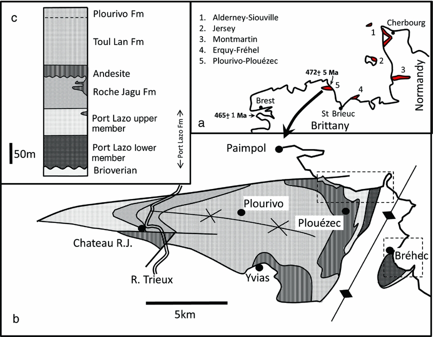
Coarse-grained, continental clastic sediments (red beds) of Palaeozoic age are widespread in NW France where they rest with unconformity on late Precambrian rocks deformed during the Cadomian Orogeny (Fig. 1a). The Cadomian Orogeny in NW France is probably best interpreted as a sinistral, transpressive, subduction-related event, climaxing at 540 Ma (Peucat, Reference Peucat1986; Treloar & Strachan, Reference Treloar, Strachan, D'Lemos, Strachan and Topley1990). The succeeding red beds are commonly bracketed as Cambro-Ordovician in age in view of their largely unfossiliferous character and loosely constrained stratigraphic control. They are commonly referred to as post-orogenic molasse-type deposits (Renouf, Reference Renouf1974), formed by erosion of the Cadomian highlands. This may be a valid description for lower Cambrian red beds (540–509 Ma) deposited immediately after the climax of the Cadomian Orogeny, but is less justified for Early Ordovician strata which were deposited 90 Ma later. Locally in Normandy, red beds clearly underlie fossiliferous marine early Cambrian strata (e.g. Alderney Sandstone Formation and its extension into the Siouville Syncline of the Cotentin peninsula). In other localities, for example at Erquy–Cap Fréhel, the age of the red beds is not so well constrained stratigraphically but a compelling similarity of facies is supportive of a comparable genesis. Locally, red beds or covering strata are intercalated with volcanic flows that have yielded convincing radiometric dates of Early Ordovician age (e.g. Auvray et al. Reference Auvray, Mace, Vidal and Van Der Voo1980; Bonjour et al. Reference Bonjour, Peucat, Chauvel, Paris and Cornichet1988). One such red-bed sequence is present in the lower Palaeozoic Plourivo-Plouézec Group where andesites interbedded with red beds have yielded a Rb–Sr date of 472±5 Ma (Auvray et al. Reference Auvray, Mace, Vidal and Van Der Voo1980), interpreted as an eruption age (Fig. 1b, c). This age date has been used to suggest that the sedimentary sequence in this basin is of Ordovician age and therefore not of immediately post-orogenic origin (Suire, Dabard & Chauvel, Reference Suire, Dabard and Chauvel1991; Egal et al. Reference Egal, Le Goff, Guennoc, Lebret, Thiéblemont, Hallégouët, Houlgatte, Callier and Carn1995).
Location and stratigraphy of the lower Palaeozoic strata of the Plourivo-Plouézec basin. (a) Location of other red-bed deposits and radiometric data. (b) Sketch map of the basin fill, partly after Auvray et al. (Reference Auvray, Mace, Vidal and Van Der Voo1980) and Egal et al. (Reference Egal, Le Goff, Guennoc, Lebret, Thiéblemont, Hallégouët, Houlgatte, Callier and Carn1995). Dashed outlines locate maps in Figures 2 and 3. (c) Stratigraphic subdivision.

The purpose of this paper is to characterize the sedimentology and stratigraphy of the Port Lazo and Roche Jagu formations and to evaluate the relationship of the andesites to the sedimentary rocks of the Plourivo-Plouézec Group. The results are used to challenge the age assigned to the different formations of the basin fill, define a regional palaeogeographic setting and add further to our knowledge of the sedimentary processes operating on early Palaeozoic palaeoenvironments.
2. Geological setting
The rocks of NW France are of late Precambrian and early Palaeozoic age and largely relate to the passing of the Cadomian orogenic cycle which climaxed at c. 540 Ma (Peucat, Reference Peucat1986; D'Lemos, Strachan & Topley, Reference D'Lemos, Strachan, Topley, D'Lemos, Strachan and Topley1990). The Precambrian rocks of the region are interpreted to relate to crustal accretion at a destructive plate boundary. The rocks include patches of >2 Ga old ‘Icartian’ basement, succeeded by a younger Neoproterozoic (600–540 Ma old) cover of metasediments and island-arc-type volcanic rocks known as the Brioverian (Rabu et al. Reference Rabu, Chantraine, Chauvel, Denis, Balé, Bardy, D'Lemos, Strachan and Topley1990). These are all intruded by abundant plutons, predominantly granitic in character (Brown et al. Reference Brown, Power, Topley, D'lemos, D'Lemos, Strachan and Topley1990). The Cadomian Orogeny in NW France is probably best interpreted as a sinistral, transpressive, subduction-related event, which climaxed at 540 Ma (Brun & Balé, Reference Brun, Balé, D'Lemos, Strachan and Topley1990; Gapais & Balé, Reference Gapais, Balé, D'Lemos, Strachan and Topley1990; Treloar & Strachan, Reference Treloar, Strachan, D'Lemos, Strachan and Topley1990). Erosion of the resulting Cadomian uplands immediately following the orogenic climax is interpreted to have resulted in the deposition of red beds and shallow marine strata, which accumulated in extensional basins opened along the prevailing structural grain (Went & Andrews, Reference Went, Andrews, D'Lemos, Strachan and Topley1990).
The lower Palaeozoic rocks of Normandy and Brittany are predominantly Cambrian and Ordovician in age (Doré, Reference Doré1972, Reference Doré, Chantraine, Rolet, Santallier, Piqué and Kleppie1994; Doré et al. Reference Doré, Juignet, Larsonneur, Pareyn and Rioult1977). In Normandy the Cambrian sequences are up to 800 m thick, in part fossiliferous, and well dated as early Cambrian. They comprise red beds succeeded by transgressive sequences of sandstones, marine shales and limestones (Doré, Reference Doré1972; Brasier, Reference Brasier1980). This deepening of the basin through early Cambrian time was associated with the transgression of an irregular shoreline in a direction from east to west (Doré, Reference Doré1972). Non-marine basin elements comprising predominantly fluvial strata have been identified draining east, towards the early Cambrian shoreline (Went & Andrews, Reference Went, Andrews, D'Lemos, Strachan and Topley1990). The middle and upper Cambrian strata are reported to be absent, reflecting a period of broad regional uplift during this time. Lower Ordovician strata of Arenig age, on the other hand, are widespread over both Normandy and Brittany. This reflects a period of renewed subsidence and marine transgression, unrelated to the Cadomian orogenic cycle, and was probably associated with the opening of the Rheic Ocean (Robardet, Paris & Racheboeuf, Reference Robardet, Paris, Racheboeuf, McKerrow and Scotese1990). In Normandy, Arenig sediments are sandstone dominated and exclusively of shallow marine affinity (the Grès Armoricain). In Brittany the Grès Armoricain is locally underlain by red beds, for example the Cap de la Chèvre Formation which is also ascribed an Arenig age (Bonjour et al. Reference Bonjour, Peucat, Chauvel, Paris and Cornichet1988).
The Plourivo-Plouézec Group comprises four formations (Auvray et al. Reference Auvray, Mace, Vidal and Van Der Voo1980; Suire, Dabard & Chauvel, Reference Suire, Dabard and Chauvel1991; Egal et al. Reference Egal, Le Goff, Guennoc, Lebret, Thiéblemont, Hallégouët, Houlgatte, Callier and Carn1995). These are, from the bottom: the Port Lazo, Roche Jagu, Toul Lan and Plourivo Shale formations. A thick sequence of andesites occurs above and within the Roche Jagu Formation. The andesites which are thick and widespread in the east of the main outcrop, but scarce in the west, are the rocks from which the radiometric age date of 472±5 Ma was obtained by Auvray et al. (Reference Auvray, Mace, Vidal and Van Der Voo1980). The vertical sequence of rocks in the group is illustrated in Figure 1c. The outcrop of the different formations is largely controlled by the folding of the sequence into a basinal syncline, albeit one cut by numerous faults. The outlier at Bréhec is separated from the main outcrop by a N–S-aligned anticline which brings Brioverian metasediments to the surface south of Pointe de Plouézec (Figs 1, 2).
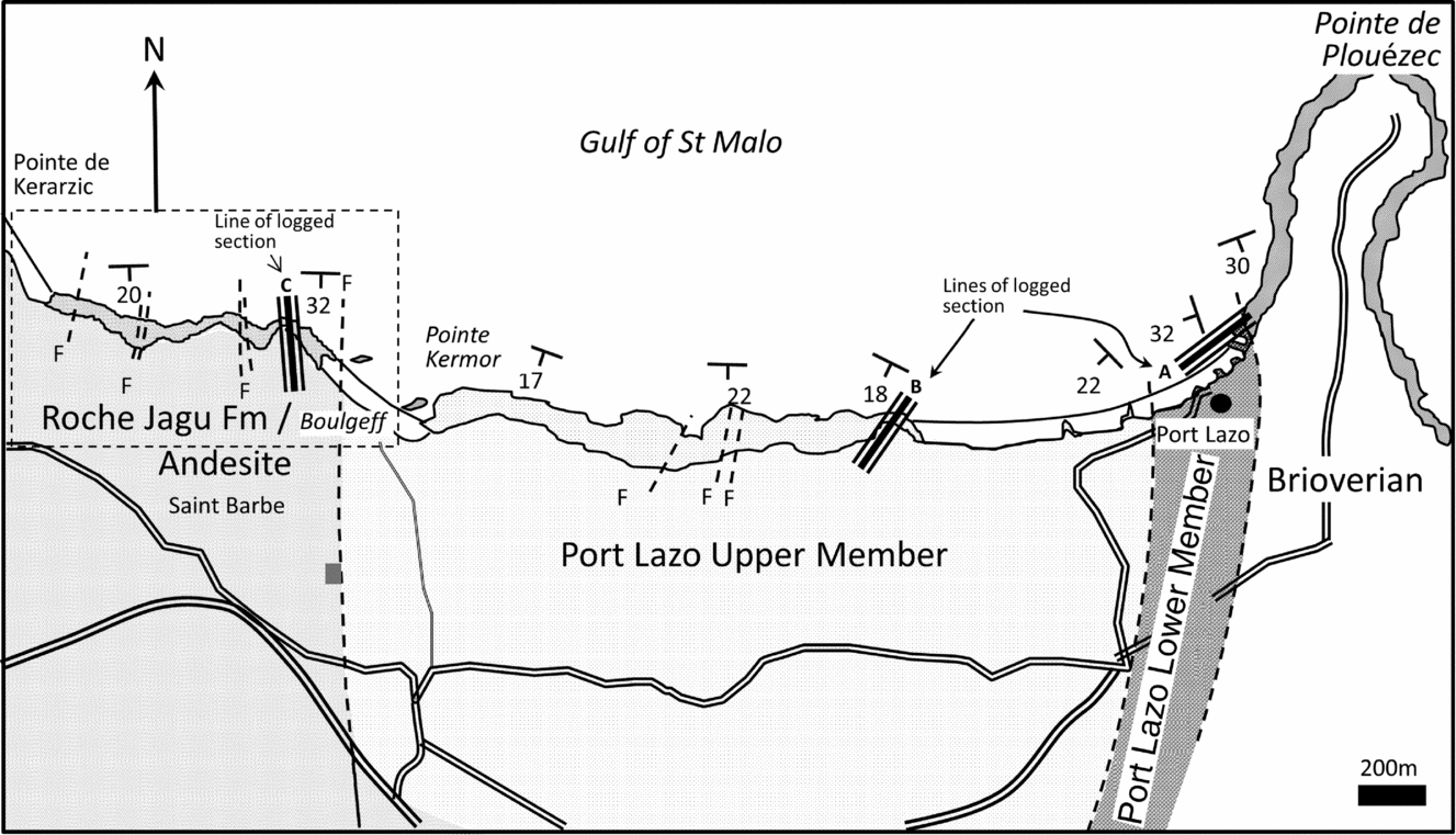
Map summarizing field relationships on the north coast from Port Lazo to Pointe de Kerarzic. Solid colour on coast denotes extent of exposure on the rock platform. Inset dashed outline refers to detail in Figure 14.

3. Methods
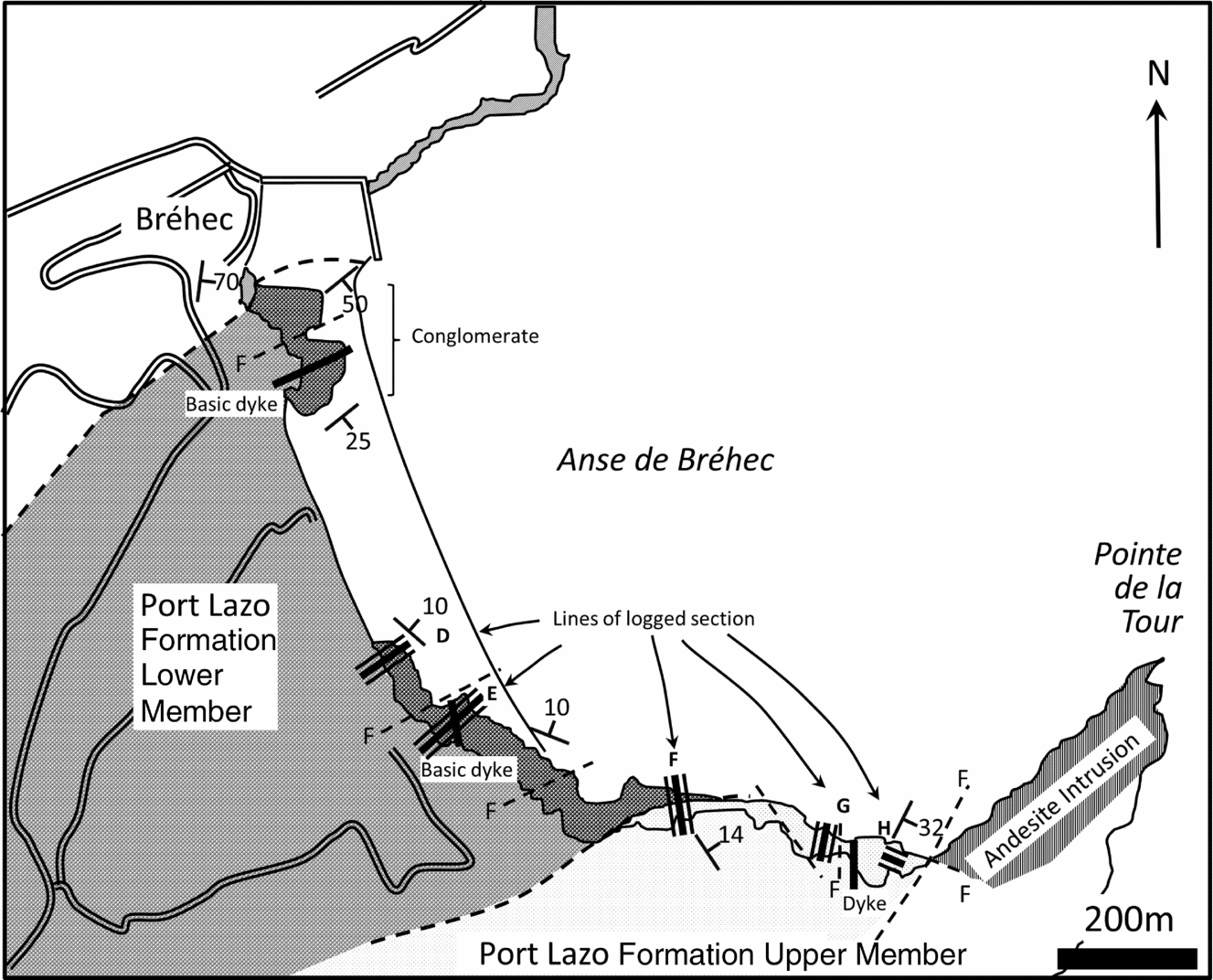
The sedimentology and surfaces bounding the formations have been studied on the coast where exposures are generally good. Field relationships were studied and data collected from Port Lazo to Pointe de Kerarzic in the main outcrop and from the outlier at Anse de Bréhec (Figs 1b, 2, 3). The best inland exposures allow for recognition of the formation present, but are not generally well suited to detailed sedimentological evaluation. Observations were nonetheless made at Chateau Roche Jagu on the west (left) bank of the River Trieux and mid-cliff at the level of the railway line on the east (right) bank of the river.
Map summarizing field relationships on the east coast in Anse de Bréhec. Solid colour on coast denotes extent of exposure on the rock platform.

Data were collected in the form of maps of field relationships, sedimentological logs of representative sections and photographs of key facies. Palaeocurrents were obtained from pebble imbrication, cross-stratification, channel margins and current ripple lamination. Recordings were made either of foreset planes directly (dip amount and direction) or as the direction of current flow as a reading of pitch in the plane of bedding (direction only), as dictated by palaeocurrent indicator and exposure type. The results were reoriented on a stereonet to remove bedding dip.
4. Port Lazo Formation
Sedimentological observations made during this study indicate that the Port Lazo Formation should be divided into two intervals or informal members. The Port Lazo Formation lower member is composed of red-coloured conglomerate, sandstone and mudstone. The Port Lazo Formation upper member is characterized by grey-coloured sandstone and subordinate mudstone. The distinction in the field is clear, but in previous work and in the notes accompanying the French Geological Survey Map it is reported solely as a change in facies (Suire, Dabard & Chauvel, Reference Suire, Dabard and Chauvel1991; Egal et al. Reference Egal, Le Goff, Guennoc, Lebret, Thiéblemont, Hallégouët, Houlgatte, Callier and Carn1995). The description of the formation as comprising two members is preferred, since it emphasizes the stratigraphic (rather than lateral) change in lithology and facies as well as the permanent (not interdigitating) and widespread nature of the change. As such, it acts as a useful subdivision of the basin fill.
4.a. Port Lazo Formation lower member
4.a.1. Bounding surfaces and thickness
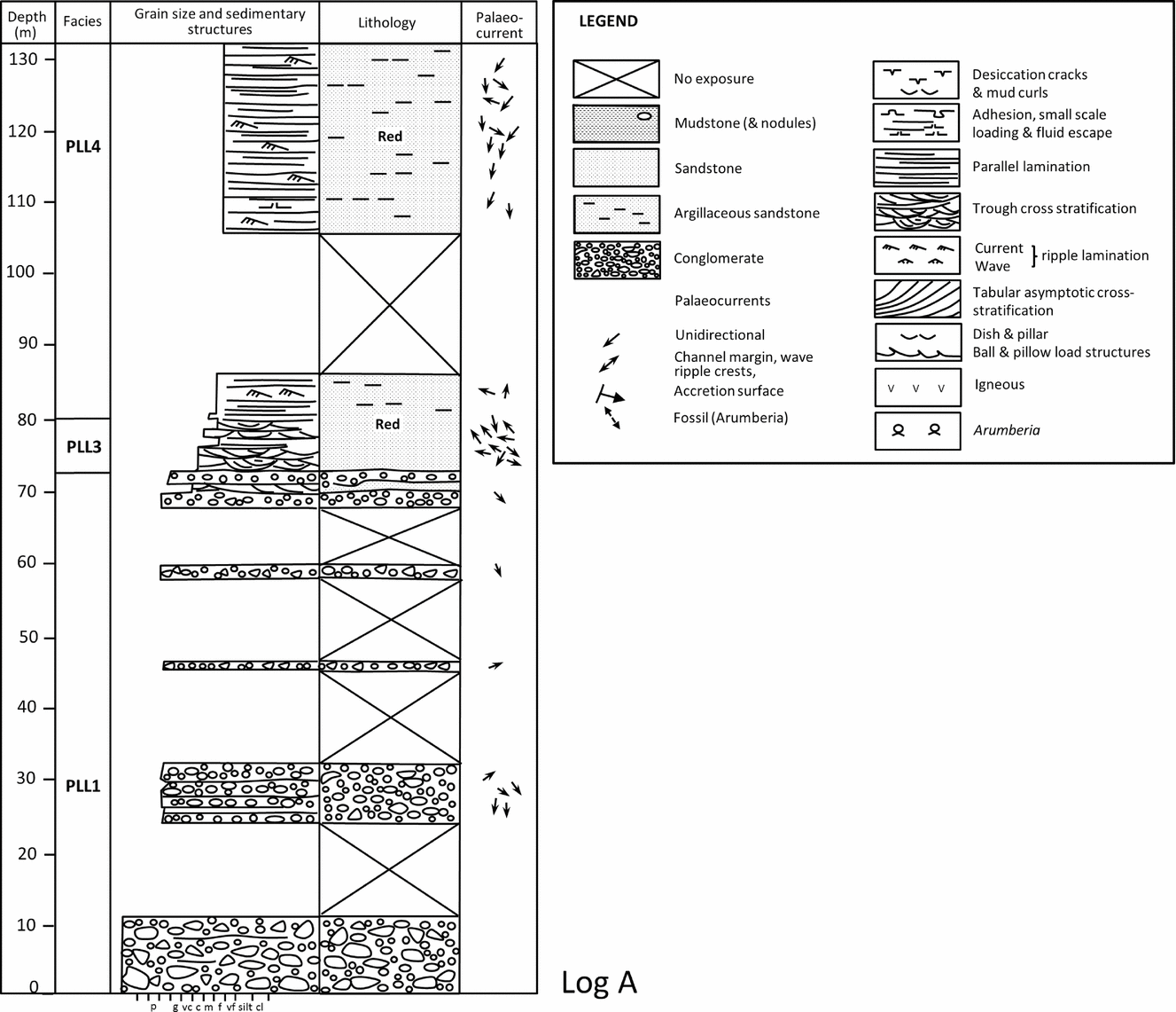
The Port Lazo Formation lower member is exposed on reefs on the foreshore at the small harbour of Port Lazo and in the Anse de Bréhec on the western and eastern limbs respectively, of a roughly N–S-striking anticline (Fig. 1). The Port Lazo Formation lower member rests unconformably on Brioverian metasediments at both locations (Figs 2, 3). The contact can be seen directly at Bréhec, and located to within c. 1 m at Port Lazo. Cobble grade conglomerate, with a few boulders, rests with marked angular unconformity on eroded Brioverian sandstones and shales at both localities (cf. Went, Andrews and Williams, Reference Went, Andrews and Williams1988; Went, Reference Went1991). The Port Lazo Formation lower member is estimated to be up to 130 m thick at Port Lazo (Fig. 4). Comparable facies occur at each locality, but the sequence is apparently somewhat thinner (50 m) in Bréhec. The fact that the member is not seen inland in the main outcrop suggests that the member may thin and be overlapped or overstepped to the south by the Port Lazo Formation upper member.

4.a.2. Facies
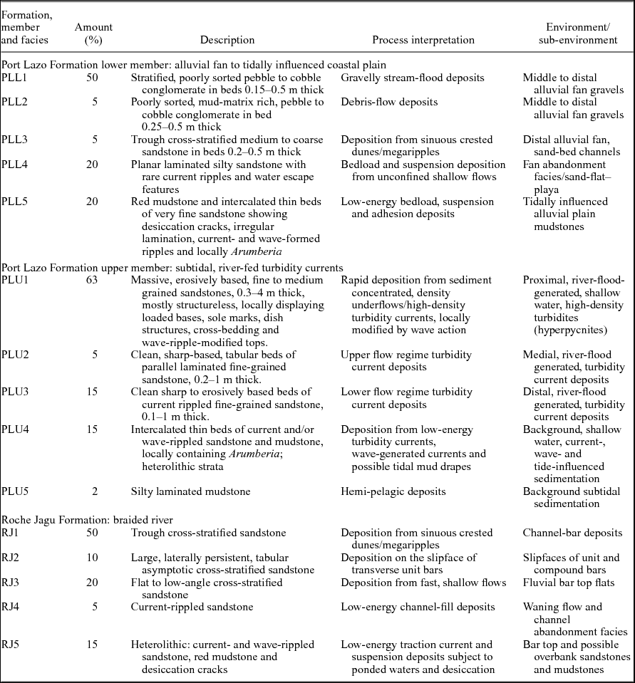
The Port Lazo Formation lower member comprises five facies: planar stratified, sand-matrix conglomerate; mud-matrix conglomerate; trough cross-stratified sandstone; laminated silty sandstone; and red mudstone (Table 1, Figs 4–7).
Summary of facies, Port Lazo and Roche Jagu formations.

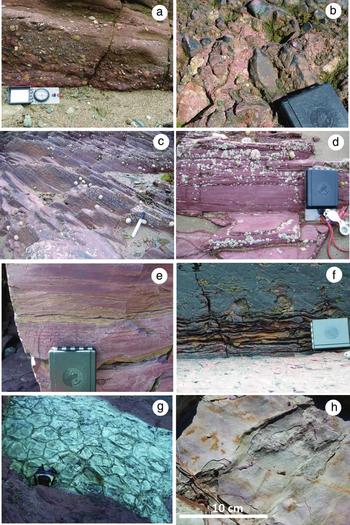
Port Lazo Formation lower member. (a) Crudely bedded and imbricated pebble conglomerate, Port Lazo. (b) Red, mud-matrix conglomerate, Bréhec. (c) Trough cross-stratified sandstone, Port Lazo. (d) Parallel and ripple-laminated very fine sandstone and siltstone, Port Lazo. (e) Red mudstone with intercalated very-fine-grained, ripple cross-laminated sandstones, Bréhec. (f) Irregular bumpy lamination interpreted as adhesion warts, Bréhec. (g) Large desiccation polygons in red mudstone, Brehec. (h) Bedding plane of red mudstone displaying fine, sub-parallel ridges and grooves, and ovoid pits typical of Arumberia, Bréhec.

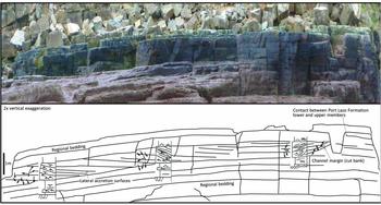
Large-scale low-angle cross-bedding interpreted as lateral accretion associated with a tidally influenced channel at the top of the Port Lazo Formation lower member. Mini logs depict sedimentary structure at three locations. Horizontal field of view is c. 30 m. View is to the south and palaeoflow is into the page. An erosion surface interpreted as the cut bank is visible on the right-hand side. Palaeocurrent orientations: north to top of page.

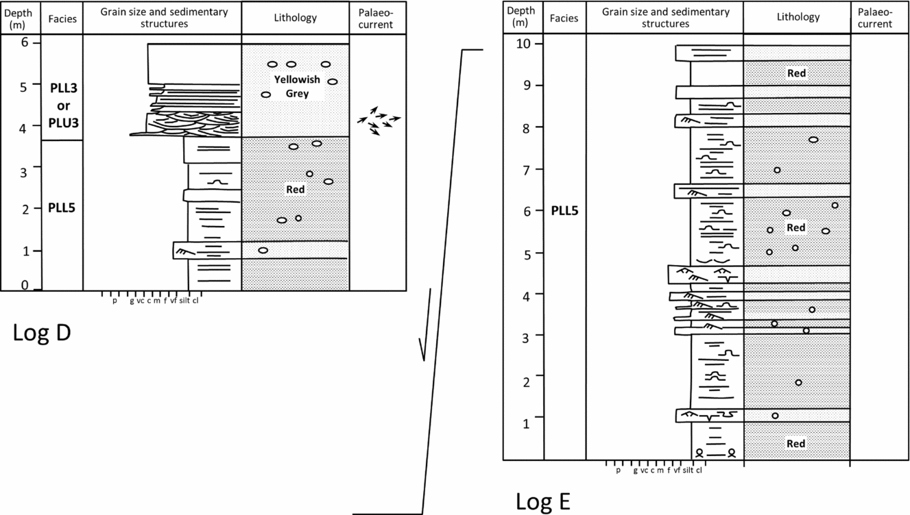
Measured sections through the upper parts of the Port Lazo Formation lower member, Anse de Bréhec.

4.a.2.a. Planar-stratified sand-matrix conglomerate (PLL1)
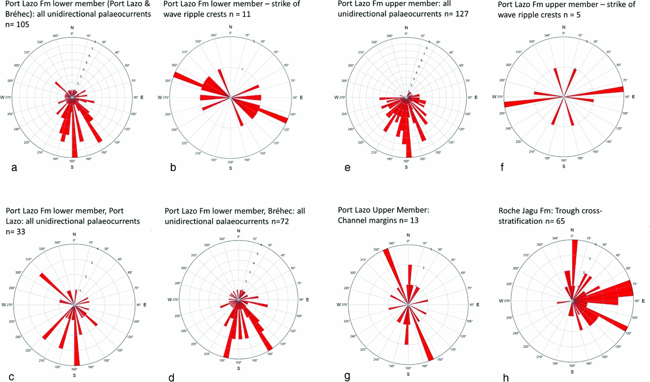
These are very poorly sorted, moderately to poorly organized, cobble to pebble grade, clast-supported conglomerates. The conglomerates show a crude horizontal, decimetre-scale bedding or stratification and the clasts are locally imbricated (Fig. 5a). Palaeocurrents obtained from pebble imbrication suggest flow to the south (Figs 4, 8). The intergranular matrix is red-coloured granular sand. The clasts are predominantly of Brioverian sandstone and shale. This facies accounts for c. 50% of the Port Lazo lower member (Table 1).
Summary of main palaeoflow indicators from (a–d) Port Lazo Formation, lower member; (e–g) Port Lazo Formation, upper member; and (h) Roche Jagu Formation.

4.a.2.b. Mud-matrix conglomerate (PLL2)
These are poorly organized, decimetre-scale beds of pebble to cobble conglomerate, locally containing larger boulders, set in a red muddy matrix (Fig. 5b). The larger clasts within this facies are largely in contact and therefore clast supported. Smaller particles, up to small pebble grade, are commonly supported by the mud matrix, however. This facies is present at Bréhec and accounts for c. 5% of the Port Lazo Formation lower member.
4.a.2.c. Cross-stratified medium-grained sandstone (PLL3)
These are typically medium-grained, red sandstones showing decimetre-scale trough cross-stratification. This facies occurs overlying conglomerate at Port Lazo and interbedded with red mudstone in Bréhec (Fig. 5c). Palaeocurrents obtained from trough foresets display a fair spread of azimuths, but mostly indicate flow to the south. However, one 2.5 m thick interval of yellowish-grey, trough cross-stratified sandstone present towards the top of the sequence in Bréhec displays easterly palaeocurrents (Fig. 7, log D). Facies PLL3 makes up c. 5% of the Port Lazo Formation lower member.
4.a.2.d. Laminated silty sandstone (PLL4)
These are red-coloured, fine- to very-fine-grained, predominantly parallel-laminated, silty sandstones. Less commonly, this facies shows current ripple cross-lamination, loading and water escape features (Fig. 5d). This facies occurs succeeding the trough cross-stratified sandstones in Port Lazo (Fig. 4) and is also present as an interval 1 m thick intercalated with conglomerate in Bréhec. Palaeocurrents obtained from ripple cross-lamination in this facies in Port Lazo and Bréhec are typically directed southwards.
4.a.2.e. Red mudstone (PLL5)
This facies is well exposed in strike section in low cliffs on the south side of the Anse de Bréhec. The contact with the underlying conglomerates, which are on the north side of the bay, is obscured by the beach at Bréhec. These are red-coloured mudstones intercalated with buff-coloured, very fine sandstones (Fig. 5e). The intercalated sandstones typically show abundant current- and wave-formed ripple lamination. Palaeocurrents obtained from ripple cross-lamination are directed to the south. Measurements of the strike of wave-formed ripple crests, exposed in plan view, are roughly E–W-trending (Fig. 8b). The mudstones display irregular, warty laminations, desiccation cracks and polygons, sand dykes and cement nodules (Fig. 5f, g). Lamination both runs through, and is deformed around, the cement nodules. Immediately beneath the contact with the Port Lazo Formation upper member, an interval of silty, very fine sandstone shows bedding-discordant, inclined stratification passing laterally to a steep erosion surface with 0.8 m of relief (Fig. 6). Palaeocurrents obtained from this interval are directed to the south and east, normal to and up the dip of the inclined bedding-discordant stratification. Locally, this facies contains probable fossil remains. These are manifest on bedding plane structures as millimetre-scale ridges and grooves associated with millimetre-scale circular to ovoid pits (Fig. 5h). These are identified as the enigmatic structure Arumberia, an Ediacarian – lower Cambrian impression fossil (Glaessner & Walter, Reference Glaessner and Walter1975; Bland, Reference Bland1984; Davies et al. Reference Davies, Lui, Gibling and Miller2016).
4.a.3. Interpretation
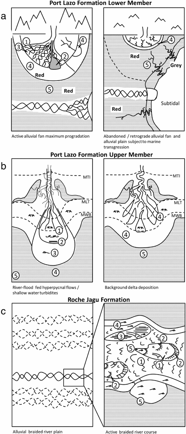
The facies of the Port Lazo Formation lower member are interpreted to represent the deposits of a southwards-building, alluvial fan to tidally influenced alluvial plain system. A continental environment of deposition is generally supported by the red colouration and abundant evidence of subaerial exposure (e.g. desiccation cracks). Petrographic data (clast composition observations plus data in Egal et al. Reference Egal, Le Goff, Guennoc, Lebret, Thiéblemont, Hallégouët, Houlgatte, Callier and Carn1995) indicate that the drainage basin was composed of Brioverian rocks. A depositional model for the Port Lazo lower member is presented in Figure 9a. Facies and environmental interpretation are further detailed in the following.
Environment of deposition. (a) Port Lazo Formation, lower member; (b) Port Lazo Formation, upper member; and (c) Roche Jagu Formation. Numbers relate to facies codes defined in the text.

The sand-matrix conglomerates (PLL1) are interpreted as waterlain stream- and sheet-flood deposits (Blair, Reference Blair1987, Reference Blair1999). The clast-supported texture and crude stratification and bedding attests to gradual aggradation of clasts from water flows. However, the very poor sorting of the clasts and locally poorly organized fabrics argues against prolonged stream flows and favours deposition from rapidly waning water floods that may, on occasion, have been hyperconcentrated to some degree (Costa, Reference Costa, Baker, Kochel and Patton1988). They are interpreted as distal alluvial fan deposits.
The mud-matrix conglomerates (PLL2), which are also poorly sorted, are interpreted as muddy debris-flow deposits (Sharp & Nobles, Reference Sharp and Nobles1953; Blair & McPherson, Reference Blair and McPherson1998). They are characteristic of, and almost unique to, alluvial fans. The mud matrix is inferred to have had relatively low cohesive strength, as suggested by the matrix support of only the smaller particles, but was nonetheless probably of significance to flow mobility and in providing buoyant support to the larger clasts (Nemec & Steel, Reference Nemec, Steel, Koster and Steel1984).
The trough cross-stratified sandstones (PLL3) attest to deposition from the migration of sinuous crested dune bedforms in turbulent water flows 2–4 m deep (Guy, Simons & Richardson, Reference Guy, Simons and Richardson1966; Allen, Reference Allen1984; Bridge & Tye, Reference Bridge and Tye2000). These are generally interpreted as distal fan, stream channel deposits. However, the yellowish-grey, trough cross-stratified sandstone intercalated with red mudstone towards the top of the sequence in Bréhec shows strong easterly palaeocurrents, and may possibly represent the deposits of a modestly sized trunk river (Figs 7, 9).
The laminated silty sandstones (PLL4) are interpreted as the deposits of practically unconfined sheet flows. Water escape features attest to the periodically saturated nature of the substrate, suggesting a fluctuating, generally high-water table such as that encountered where alluvial fans transition to mud-dominated flats or playas (Hardie, Smoot & Eugster, Reference Hardie, Smoot, Eugster, Matter and Tucker1978; Hubert & Hyde, Reference Hubert and Hyde1982; Tunbridge, Reference Tunbridge1984). This facies may represent deposition marginal to an active retreating alluvial fan system or, alternatively, reflect the abandonment of the pre-existing fan system (Heward, Reference Heward and Miall1978).
The red mudstones (PLL5) are interpreted to represent deposition on a playa to tidally influenced alluvial plain. Playas (mudflats) are commonly observed marginal to alluvial fan systems (Hardie, Smoot & Eugster, Reference Hardie, Smoot, Eugster, Matter and Tucker1978; Hubert & Hyde, Reference Hubert and Hyde1982) where they may merge into alluvial plains. Fine-grained sediment dominates in both environments, the distinction being that sediment on the alluvial plain is largely supplied by a trunk fluvial system. There is limited evidence for a trunk river, although a possible exception is the yellowish-grey, trough cross-stratified sandstone seen near the top of the mudstone sequence (Figs 7, 9). Tidal influences are inferred from the presence of Arumberia and the evidence of small migratory channels towards the top of the sequence.
The wave-formed ripples present in the fine and very fine sandstones within the mudstones attest to winds blowing over shallow water, possibly ephemeral lakes formed through flooding or alternatively from tidal influx. On the other hand, the abundant intervals showing desiccation cracks and sand dykes clearly point to periods of subaerial exposure and confirm this is a continental environment of deposition (Oomkens, Reference Oomkens1966; Tunbridge, Reference Tunbridge1984). The irregular warty laminations are interpreted as adhesion structures (Kocurek & Fielder, Reference Kocurek and Fielder1982). They may have been formed entirely by physical processes of wetting and drying or, alternatively, have involved the presence of algal films (Davies et al. Reference Davies, Lui, Gibling and Miller2016). The initial formation of the cement nodules in the mudstones was relatively early, as indicated by some differential compaction that occurs around them, and may have developed via early diagenesis associated with the fluctuating water table levels. Arumberia is believed to have been formed by a microbial organism adapted to mixed salinity and periodically desiccated environments (Kumar & Pandey, Reference Kumar and Pandey2009; Kolesnikov, Grazhdankin & Maslov, Reference Kolesnikov, Grazhdankin and Maslov2012) and is therefore consistent with a tidally influenced alluvial plain.
The inclined stratification at the very top of the sequence is interpreted to reflect lateral accretion on a very-fine-grained bank-attached bar and the associated erosion surface, the cut bank. The inclined surfaces dip towards the cut bank and contain current ripples which indicate flow to the south, orthogonal to and, in places, up the depositional dip of the accretionary surface, suggestive of a component of helical flow accompanying lateral migration of the channel (Fig. 6). The channel evidently lay dry for periods of time judging by the desiccation cracks formed throughout the sequence and, when in flow, was of low energy with only ripple bedforms developed. Muddy point bars tend to be associated with tidally influenced channels in coastal parts of alluvial plains (Stewart, Reference Stewart, Collinson and Lewin1983; Thomas et al. Reference Thomas, Smith, Wood, Visser, Calverley-Range and Koster1987), an observation consistent with the immediate change upwards to grey sediment of the Port Lazo Formation upper member, which is interpreted to be subtidal marine in origin. Nevertheless, fluvial or ebb flow discharge was evidently dominant as only southwards flow is observed.
The coarse facies present in the Port Lazo Formation lower member bear a striking resemblance to the facies of the Rozel Conglomerate Formation (Went, Reference Went2005). The latter likewise contains a reported occurrence of Arumberia (Bland, Reference Bland1984). The proportions of the different facies present in the two formations highlights that the Port Lazo Formation lower member was probably deposited in a more distal fan setting than the Rozel Conglomerate Formation.
4.b. Port Lazo Formation upper member
4.b.1. Bounding surfaces and thickness
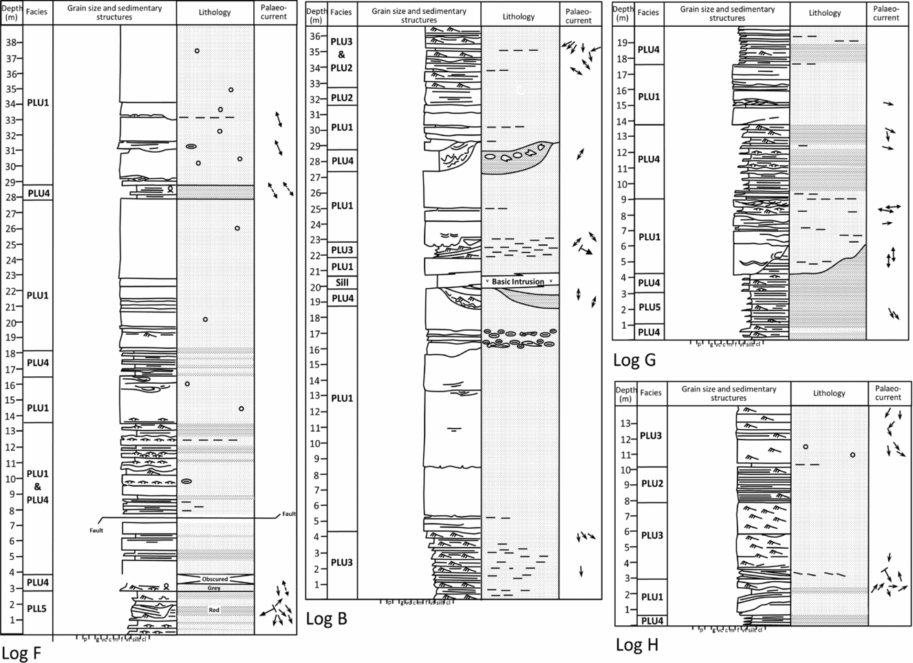
The contact between the Port Lazo Formation lower and upper members is not exposed on the north coast west of Port Lazo, where a 100 m section of beach gravels separates the two nearest exposures. However, it is exposed in the Anse de Bréhec where the two members are in structural conformance. A measured section through the contact is shown in Figure 10 (log F). Red mudstone and very fine sandstone is succeeded by current-rippled fine grey sandstone and mudstone. The beds immediately above the contact contain examples of an impression fossil comparable to Arumberia (Fig. 11f). A fault and boulders from a rock fall prevent the viewing of an uninterrupted section above the contact. However, there is a rapid transition to thick massive sandstones and intercalated, thin mudstones. The top of the formation in Bréhec is a faulted contact with an andesite intrusion (Fig. 3). The total thickness of the upper member to the fault contact is on the order of 100 m.
Measured sections through the Port Lazo Formation upper member, Anse de Bréhec (logs F, G, H) and Boulgeff (log B)

On the north coast west of Port Lazo to Pointe Kermor the member crops out in strike section. The top and base are not exposed. The base may well be conformable; however, the top is undoubtedly faulted. The fault contact with the Roche Jagu Formation runs through the west of the bay at Boulgeff. A number of faults cut the section from Port Lazo to Boulgeff, making thickness estimates problematic. However, c. 60 m of section is estimated to be present. The mapping of Auvray et al. (Reference Auvray, Mace, Vidal and Van Der Voo1980) and Egal et al. (Reference Egal, Le Goff, Guennoc, Lebret, Thiéblemont, Hallégouët, Houlgatte, Callier and Carn1995) suggests the formation thins to the south in the main outcrop, where it is overlapped or overstepped by andesites (Fig. 1).
4.b.2. Facies
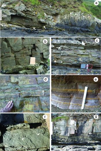
Five depositional facies are identified in the Port Lazo Formation upper member. A summary of the depositional characteristics of the facies, their relative abundance and interpretation are presented in Table 1. They are further described in the following sections and illustrated in Figure 11.
Port Lazo Formation Upper Member. (a) Thick bedded, erosively based sandstones showing prominent load structures at contact with inclined heterolithic strata (left arrow), channel margin (middle arrow) and steep-sided mud- and sand-filled channel above surface marked with right arrow. (b) Flat laminated clean sandstone (board for scale is 30 cm high). (c) Current ripple-laminated fine sandstone. (d) Heterolithic strata with beds of sandstone comprising symmetrical wave-formed ripples draped with alternating thin layers of mudstone and sandstone (arrowed). (e) Parallel laminated silty mudstone. (f) Bedding plane view of large Arumberia at the base of the upper member in Bréhec. (g) Stepped erosional contact (at hammer head, arrowed) between thick massive sandstone and unit of inclined heterolithic strata.

4.b.2.a. Thick bedded, massive sandstones (PLU1)
These are thick beds (0.4–5 m) of grey-coloured, fine- to medium-grained, largely structureless sandstone. Locally the sandstones display dish and pillar structures, faint parallel lamination or minor decimetre-scale cross-bedding. Beds show sharp, planar to channelized erosive bases, locally with sole marks or ball and flame load structures (Table 1; Fig. 10a). Bed tops locally display wave ripple forms, or may be incised by deep channels (Fig. 9, logs F and B). This facies contains common nodular concretions. Palaeocurrents obtained from channel margins are oriented NNW–SSE and wave ripple crests strike approximately E–W (Fig. 8f, g). This facies accounts for c. 60% of the Port Lazo Formation upper member.
4.b.2.b. Parallel laminated sandstone (PLU2)
These are sharp-based, tabular beds 30–50 cm thick of clean, grey-coloured fine to medium sandstone showing parallel lamination. They locally stack vertically to form bed sets 1–2 m thick (Fig. 11b). This facies accounts for 5% of the Port Lazo Formation upper member.
4.b.2.c. Current-ripple-laminated sandstone (PLU3)
These are sharp-based, tabular units of clean current-ripple-laminated sandstone organized in beds and bed sets 0.1–2 m thick (Figs 10 (logs B, H), 11c). The beds typically show negligible grading and the current ripple lamination displays low angles of climb. Palaeocurrents obtained from current-ripple lamination are unambiguously directed to the south. This facies accounts for c. 15% of the Port Lazo Formation upper member and is commonly intercalated with facies PLU2.
4.b.2.d. Heterolithic strata (thin interbeds of sandstone and mudstone) (PLU4)
These are thin tabular beds (2–20 cm thick) of intercalated fine-grained sandstone and parallel laminated grey to purple mudstone (Figs 10 (log G), 11d). The thin sandstone beds are typically sharp or erosively based, locally graded and commonly display current and wave ripple forms and cross-lamination. Locally thin, millimetre-scale couplets of mudstone and very fine sandstone drape the sandstones beds. The intervals of heterolithic strata which are 0.5–5 m thick locally display examples of Arumberia, but are otherwise devoid of trace or body fossils. Heterolithic strata locally show evidence of gravity-induced deformation and convolution.
4.b.2.e. Parallel laminated mudstone (PLU5)
These are intervals 0.25–2 m thick of parallel laminated grey to purple mudstone (Figs 10 (log G), 11e). They comprise centimetre-scale beds of normally graded siltstone and claystone and constitute c. 5% of the total interval. The parallel laminated mudstones commonly show evidence of gravity-induced, post-depositional modification including recumbent folded intervals, slumped bedding and convolution.
4.b.3. Stratal architecture
The sedimentary facies described are associated with some distinctive architectural elements. Although vertical stacking of tabular bedded sandstone and shale is commonly observed, evidence of channelling is also widespread. Many of the massive sandstone (facies PLU1) show channelized bases with relief of 1–2 m as described in the sedimentary logs and photos (Figs 10, 11). Also common are deep channel scours 1–3 m deep, with heterolithic fills. The heterolithic fills variously show sandstone pillows loaded into convoluted mudstone, thin beds of alternating rippled sandstone and mudstone, and locally thicker channelized sand bodies forming a composite fill to a larger channel. Smaller-scale (centimetre–decimetre-deep) channel bodies are less conspicuous, but also locally present. Lenticular sandstone bodies several metres to tens of metres wide are locally arranged as shingled stacks with the shingling occurring approximately perpendicular to palaeoflow. Partings of mudstone commonly separate the sandstone bodies in these cases. Also common are intervals of more mudstone-dominated heterolithic material which shows inclined bedding relative to regional dip. The inclination of the strata in these intervals also tends to be perpendicular to the prevailing palaeocurrent (Fig. 11g).
4.b.4. Interpretation
The grey colouration and lack of any indicators of subaerial exposure suggests deposition took place in a subtidal environment. Deposition is interpreted to have occurred in the subtidal parts of a southwards building delta or estuary, as depicted in Figure 8b. The bulk of sedimentation is interpreted to have occurred during river flood in the form of hyperpycnal turbidity current flows. Subordinate deposition is interpreted to have occurred as background sedimentation in a low-energy wave and tide-influenced environment. Facies interpretations and environmental analysis are detailed in the following.
The prominent thick beds of structureless or dewatered sandstone (PLU1) with erosive and commonly loaded bases point to deposition from mass flows, specifically high-density turbidity currents (Lowe, Reference Lowe, Doyle and Pilkey1979, Reference Lowe1982; Kneller & Branney, Reference Kneller and Branney1995). The sharp to erosively channelized bases and localized association with channel cuts suggest a largely channelized origin. They are interpreted as the product of density underflows (hyperpycnal flows) formed at the mouths of major river channels in times of flood (Plink-Björklund & Steel, Reference Plink-Björklund and Steel2004). The underflows are believed to have resulted from high river discharges and sediment loads (Burgess & Hovius, Reference Burgess and Hovius1998; Mulder et al. Reference Mulder, Syvitski, Migeon, Faugeres and Savoye2003). Turbid sediment-rich waters entered the sea and transitioned to density flows at a plunging zone, in this case probably the top of the delta front (Mulder et al. Reference Mulder, Syvitski, Migeon, Faugeres and Savoye2003). High-density turbidity currents resulted in much rapid deposition on the delta front as flow competence was lost offshore (Nelson, Reference Nelson1982). The ball and flame structures which are locally present in this facies attests to the weight of sediment introduced on deposition (Mutti et al. Reference Mutti, Tinterri, Magalhaes and Basta2007). Periodically during flows, the rate of sediment deposition was reduced allowing localized planar lamination and traction bedforms to develop. This is consistent with modern river-fed hyperpycnal flows which, although they tend to last for several days or weeks, may ebb temporarily (Mulder et al. Reference Mulder, Syvitski, Migeon, Faugeres and Savoye2003). The interpretation places sediment deposition in subtidal channels immediately offshore of the fluvial/tidal mouth bar. The localized moulding of the tops of massive sandstones into wave-formed ripples attests to the action of waves touching the water bottom, confirming that the massive sandstones were deposited in relatively shallow water, certainly above wave base (Raaf, Boersma & Gelder, Reference Raaf, Boersma and Gelder1977). Locally, where the sandstones and wave ripple forms occur associated with thin couplets of sandstone and mudstone (Fig. 11d) they resemble tidal rhythmites (Rahmani, Reference Rahmani, Boer and Van Gelder1988). This suggests the sediments may have been modified by both waves and tides, the mud deposition occurring via particle flocculation during slack water periods (Reading & Collinson, Reference Reading, Collinson and Reading1996).
The tabular bedded intervals of parallel laminated sandstone (PLU2) are interpreted to reflect upper flow regime, plane bed deposition from turbidity currents (Bouma, Reference Bouma1962; Lowe, Reference Lowe1982). This facies is locally transitional to facies PLU1 and is interpreted to reflect slower rates of bed aggradation than for the massive sandstone deposition. This facies is not generally associated with conspicuous channelling and, as such, it is interpreted to reflect deposition from less concentrated, unconfined flows in a slightly more distal environmental setting.
The beds of current-ripple-laminated sandstone (PLU3) are also interpreted as turbidity current deposits, reflecting aggradation under lower-flow-regime conditions (Bouma, Reference Bouma1962; Lowe, Reference Lowe, Doyle and Pilkey1979, Reference Lowe1982). The fairly thick tabular beds of ripple cross-lamination are interpreted to reflect deposition from fairly sustained, unconfined flows in a medial to distal environmental setting. Deposition from fairly long-duration sustained flows is deduced from the fairly thick beds, lack of conspicuous grading and low angle of climb associated with the ripple cross-lamination. The general lack of wave-formed structures suggests this facies was deposited below fair-weather wave base.
The intervals of heterolithic strata, comprising thin beds of current and wave-ripple-laminated sandstone and silty mudstone are interpreted to reflect low-energy sedimentation either in areas marginal to the main locus of hyperpycnal turbidity current deposition or outside times of major flood activity. The thin, graded beds of current-ripple-laminated sandstone are interpreted to reflect deposition from dilute turbidity current flows of short duration. The occurrence of wave-formed ripples indicates deposition took place in relatively shallow waters, an observation consistent with the occurrence of Arumberia in this facies. The mud–sand couplets locally present in this facies may furthermore reflect shallow-water deposition through the action of tides (Rahmani, Reference Rahmani, Boer and Van Gelder1988; Visser, Reference Visser1980; Dalrymple, Zaitlin & Boyd, Reference Dalrymple, Zaitlin and Boyd1992).
Intervals of laminated mudstone, comprising normally graded centimetre-scale beds of siltstone and claystone, are interpreted to reflect deposition from very-low-energy turbidity currents. They are interpreted to have been deposited in an environment marginal to and/or distal from that of PLU4.
Palaeocurrents, obtained mostly from current ripple lamination, are strongly unidirectional and indicate that the observed turbidity-current-dominated wedge of delta sediments built southwards through time. Most of the sediment is interpreted to have come from fluvially generated underflows. Loading from these dense flows or seismic events in the basin may have triggered slides and dewatering on the delta front, resulting in the occurrences of chaotic beds and recumbent folded strata (Damuth, Reference Damuth1994; Mulder & Cochonat, Reference Mulder and Cochonat1996; Morgan, Reference Morgan, Arthur, MacGregor and Cameron2003, Briggs et al. Reference Briggs, Davies, Cartwright and Morgan2006).
The evidence for large-scale, deeply incised channels in the Port Lazo Formation upper member is interpreted to reflect deposition in a setting close to the river mouth. The cuts are tentatively ascribed to the turbidity current delivery process, and were in many cases filled by the same event. In some cases, however, the deep channel cut was evidently filled in multiple stages and partly by later events. The channel fills that comprise both sandstone and mudstone were clearly filled by a mixture of events of low and high energy.
The shingled sandstone bodies and inclined heterolithic strata occur in intervals showing evidence for channelling. These strata are inclined in a direction perpendicular to palaeoflow and are interpreted as lateral accretion surfaces formed on bank-attached bars associated with the subtidal channels. Such channels and facies are present in the subtidal parts of deltas, and are common on submarine slopes in both the Niger and Nile deltas (Peakall, McCaffrey & Kneller, Reference Peakall, McCaffrey and Kneller2000; Posamentier & Kolla, Reference Posamentier and Kolla2003; Samuel et al. Reference Samuel, Kneller, Raslan, Sharp and Parsons2003; Peakall et al. Reference Peakall, Amos, Keevil, Bradbury and Gupta2007).
5. Roche Jagu Formation
The Roche Jagu Formation takes its name from the château which lies above the River Trieux, where sandstones are exposed on the banks of the river and in railway cuttings on the east (right) bank (Fig. 1). The best exposures of this formation, however, are on the north coast between the small port of Kerarzic and the beach at Boulgeff, where andesite is also present (Fig. 2).
5.a. Bounding surfaces and thickness
The contact between the Port Lazo Formation upper member and the Roche Jagu Formation is not exposed in the bay at Boulgeff, but lies under the western part of the beach. Structural-stratigraphic considerations determine that the contact must be faulted (Fig. 2).
The contact between the Port Lazo Formation upper member and the Roche Jagu Formation elsewhere in the Plourivo-Plouézec outcrop is typically obscured from view and assumed to be faulted (Egal et al. Reference Egal, Le Goff, Guennoc, Lebret, Thiéblemont, Hallégouët, Houlgatte, Callier and Carn1995). However, a structurally conformable superposition on the River Trieux is reported by Egal et al. (Reference Egal, Le Goff, Guennoc, Lebret, Thiéblemont, Hallégouët, Houlgatte, Callier and Carn1995) who note red sandstones replacing grey beds of alternating sandstone and mudstone. The thickness of the Roche Jagu Formation is estimated by Egal et al. (Reference Egal, Le Goff, Guennoc, Lebret, Thiéblemont, Hallégouët, Houlgatte, Callier and Carn1995) to be up to 80 m.
5.b. Facies
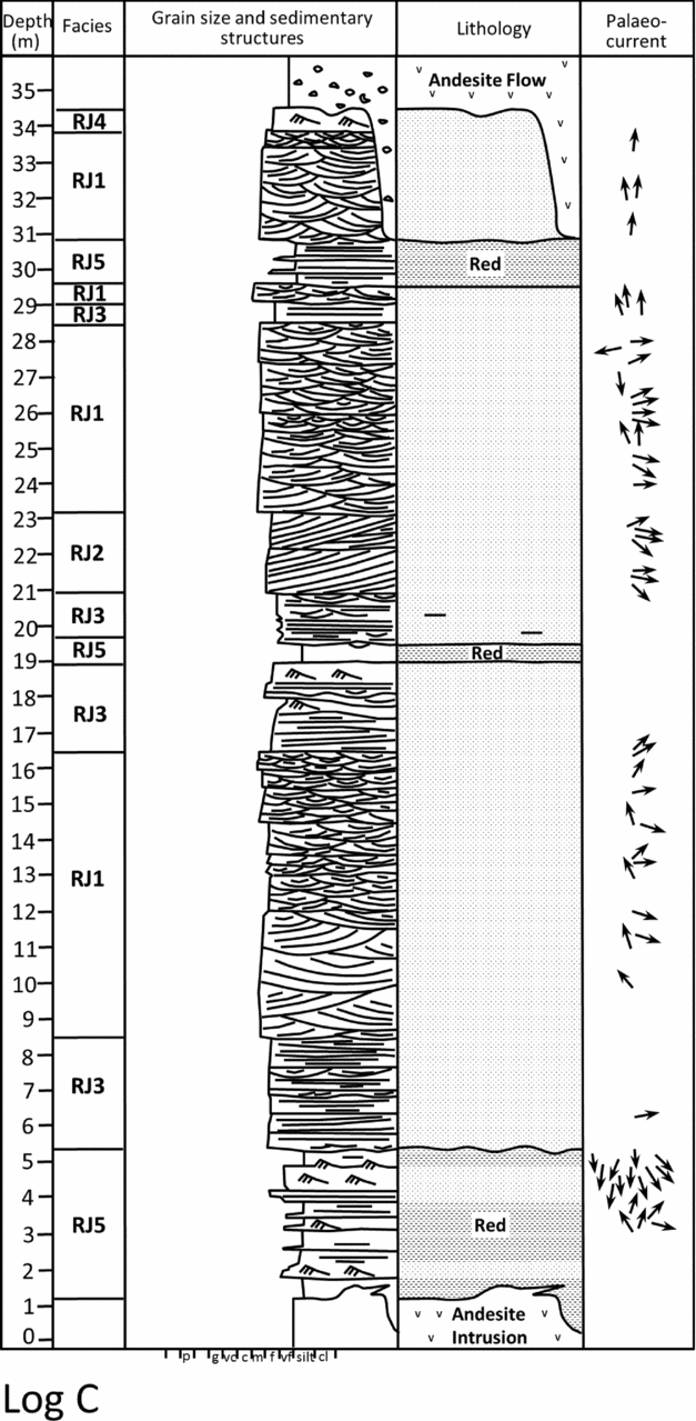
The Roche Jagu Formation is subdivided into five facies. These are trough cross-stratified sandstone, tabular asymptotic cross-stratified sandstone, flat to low-angle cross-stratified sandstone, ripple cross-laminated sandstone and heterolithic intervals of sandstone and red mudstone. The facies are summarized in Table 1 and illustrated in Figures 12 and 13.
Measured section through the Roche Jagu Formation, west of Boulgeff.

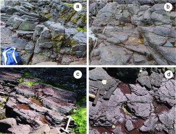
Roche Jagu Formation. (a) Trough cross-stratified sandstone; (b) large-scale tabular asymptotic sandstone; base of foreset at level of hammer head; (c) heterolithic strata comprising interbedded fine sandstone and red mudstone; and (d) bedding plane view of red mudstone showing sand-filled desiccation cracks. All photos Boulgeff to Pointe de Kerarzic.

5.b.1. Trough cross-stratified sandstone (RJ1)
These are beds, 20 cm to 3.5 m thick, of fine- to medium-grained sandstone showing trough cross-stratification (Fig. 13a). Beds are erosively based and typically stacked to form intervals several metres thick (Fig. 12). Sets of trough cross-stratification of thickness 15–50 cm predominate. Average set height is 30 cm and maximum set height is 1 m. Palaeocurrents obtained from trough foresets and trough axes indicate a current flow to the east (Fig. 8).
5.b.2. Tabular asymptotic cross-stratified sandstone (RJ2)
These are beds c. 1–1.5 m thick of fine-grained sandstone showing tabular asymptotic cross-stratification. The beds are laterally persistent for over 150 m where seen in strike section east of Kerarzic. They show a number of reactivation surfaces. Maximum dips are c. 30°, approximately at the angle of repose. The foresets become asymptotic at the base. Palaeocurrents show flow to the SE broadly similar to the results obtained from trough cross-stratification (Fig. 12).
5.b.3. Flat to low-angle cross-stratified fine sandstone (RJ3)
These are beds c. 0.5–1 m thick of fine sandstone showing flat stratification or very-low-angle cross-stratification. Beds are commonly stacked into intervals up to 3 m thick with thin laterally discontinuous beds of trough cross-stratification locally interleaved. The few palaeocurrents obtained from the low-angle cross-strata are oriented NE, broadly similar to the results obtained from trough cross-strata.
5.b.4. Ripple cross-laminated fine sandstone (RJ4)
These are beds 50 cm thick of current-ripple cross-laminated sandstone. They are typically found capping bed sets of trough cross-stratification (Fig. 12).
5.b.5. Heterolithic fine sandstone and red mudstone (RJ5)
These are intervals typically 1–2 m thick which show intercalated tabular beds of fine current-ripple-laminated sandstone and red mudstone. The mudstones locally show desiccation cracks and sand dykes up to 1 cm wide. These are particularly conspicuous in bedding plane exposures where they display polygonal geometries (Fig. 13c, d). Palaeocurrents from ripple cross-lamination are limited in number (n = 16) and show modes to the south and north.
5.c. Interpretation
The facies, palaeocurrents and red colouration of the Roche Jagu Sandstones is interpreted to reflect deposition in an easterly flowing, braided river depositional environment, as depicted in Figure 9c.
The trough cross-stratified sandstones (RJ1) are interpreted as fluvial channel sandstones. The sets of trough cross-strata attest to deposition from sinuous crested dune bedforms in unidirectional water flows of the order 5–7 m deep (Yalin, Reference Yalin1964; Guy, Simons & Richardson, Reference Guy, Simons and Richardson1966; Allen, Reference Allen1968; Bridge & Tye, Reference Bridge and Tye2000). The erosive bed bases and inferred water depths suggest the flows were confined in channels. The repeated stacking of erosively based beds of trough cross-stratification attests to frequent avulsion of the channels, suggesting the river course was braided in character. The palaeocurrents are unidirectional and indicate flow to the east. The red colouration and intercalation with other facies, showing evidence for subaerial exposure, confirms the environment was continental and the sediments periodically exposed to desiccation (Cotter, Reference Cotter and Miall1978; Todd & Went, Reference Todd and Went1991; Collinson, Reference Collinson and Reading1996).
The tabular asymptotic cross-stratified sandstones (RJ2) are interpreted as the slipfaces to transverse unit bars (Smith, Reference Smith1972; Cant & Walker, Reference Cant and Walker1978; Bridge & Lunt, Reference Bridge, Lunt, Sambrook, Best, Bristow and Petts2006). The palaeocurrents obtained from this facies are to the SE, suggesting flow either parallel to that in the main channels or at a low angle to it. The lateral extent of these foresets and the presence of reactivation surfaces suggest these were semi-permanent features probably established on larger compound bars within the river course. These are therefore interpreted as the slipfaces to unit bars dipping broadly parallel with the main channel axes. The scale of the slipfaces is also consistent with flows of several metres depth.
The flat to low-angle cross-stratified sandstones (RJ3) are interpreted as sandy, inter-channel bar flats. The flat stratification is interpreted to have formed as upper flow regime planar lamination or locally, from the migration of very-low-amplitude sandwaves formed in the fast, very shallow waters flowing over the bar flats (Smith, Reference Smith1971; Harms et al. Reference Harms, Southard, Spearing and Walker1975; Cant & Walker, Reference Cant and Walker1978). The laterally impersistent beds of small-scale trough cross-stratification are interpreted as the dune-covered floors of small channels crossing the bar top flats and draining flood waters back into the main channels (Bridge & Lunt, Reference Bridge, Lunt, Sambrook, Best, Bristow and Petts2006).
The relatively thin beds of ripple cross-laminated sandstone (RJ4) capping bed sets of trough cross-stratification are interpreted as channel abandonment deposits. The low-energy bedforms are observed capping fining-upwards and thinning-upwards bed sets of trough cross-strata which themselves show decreasing set size. These are therefore interpreted as the final low-energy flows filling aggrading channel courses.
The heterolithic strata (RJ5), comprising tabular beds of fine ripple cross-laminated sandstone and red mudstone, are interpreted as the deposits of weakly confined to unconfined flows. The palaeocurrents obtained from the ripple cross-laminated sandstones that show north and south modes might be interpreted to reflect flows dispersing at a high angle to the main channel direction. The intercalated mudstones suggest suspension deposition from temporarily ponded waters. The sand-filled mudcracks attest to the subaerial exposure of these red mudstones. Deposition may have occurred on the low-energy (bar tail) parts of large compound bars (Bridge & Lunt, Reference Bridge, Lunt, Sambrook, Best, Bristow and Petts2006) or on levees/flood basins (Collinson, Reference Collinson and Reading1996). There is insufficient exposure to be able to discriminate between the two possibilities (cf. Ielpi & Ghinassi, Reference Ielpi and Ghinassi2015).
6. Andesite and Toul Lan Formation
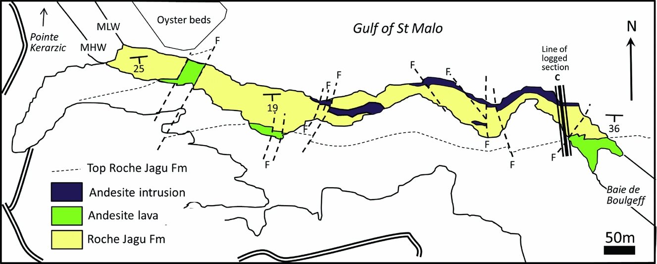
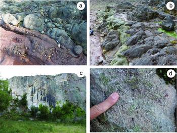
Andesite is found predominantly in the east and south of the main outcrop (Fig. 1) where it reaches a maximum of 80 m thick (Egal et al. Reference Egal, Le Goff, Guennoc, Lebret, Thiéblemont, Hallégouët, Houlgatte, Callier and Carn1995). Exposures of andesite occur in quarries and on the coast. The best exposures are found on the north coast between Boulgeff and Pointe Kerarzic, where andesite occurs at six localities in contact with sandstones of the Roche Jagu Formation (Fig. 14). The characteristics and field relationships have been studied at each of these six localities. Amydaloidal andesite, greyish purple in colour, occurs overlying the top of the Roche Jagu Formation at three localities which are correlated as shown in Figure 14. The evidence of a vesicular texture (now amydaloidal) attests to the free escape of gas from the magma and suggests these andesites are best interpreted as extrusive lava flow deposits (Fig. 15a). The contact between the lavas and the underlying sandstones is erosional, with relief of up to 4 m (Fig. 12). The nature of the surface suggests an unconformity, albeit one with no major angular discordance. The remaining andesite bodies are all non-amydaloidal. The boundaries of some of these andesite bodies are approximately parallel to bedding. However, detailed examination reveals areas of bedding-discordant contact with the sandstones in all of the bodies (Fig. 15b). Sandstone stratification is either destroyed through baking or runs right up to the andesite body; there is no change of facies or weathering products associated with the irregular boundaries of the andesites. No clasts of andesite are found in the sandstones. These properties all confirm that the non-amydaloidal andesites are intrusions. Both the lavas and the intrusions therefore post-date the Roche Jagu Sandstones. This has major implications for the interpretation of radiometric data obtained from the andesites by Auvray et al. (Reference Auvray, Mace, Vidal and Van Der Voo1980). Far from being indicative of an Ordovician (Arenig) age for the Port Lazo and Roche Jagu formations, it suggests they are actually pre-Arenig in age.
Map summarizing field relationships on the north coast from Baie de Boulgeff to Pointe de Kerarzic (see inset in Fig. 2).

(a) Amydaloidal andesite lava erosive on red mudstone of the Roche Jagu Formation. (b) Andesite intrusion (grey) into red sandstone of the Roche Jagu Formation. (c) Pale whitish pebbly sandstone of the Toul Lan Formation, bedding arrowed. (d) Close-up view of the granular sandstone showing rounded larger grains, Toul Lan Formation.

The Toul Lan Formation overlies either the andesite or the Roche Jagu Formation but is exposed only in inland locations where it is up to 150 m thick. The best exposures occur in large disused quarries where decimetre-scale beds of white to pink, pebbly sandstone are characteristic (Fig. 15c, d). The granular and pebbly components include jasper and vein quartz and are sub-rounded in form. Towards the top of the formation marine trace fossils have been observed (Egal et al. Reference Egal, Le Goff, Guennoc, Lebret, Thiéblemont, Hallégouët, Houlgatte, Callier and Carn1995).
7. Discussion
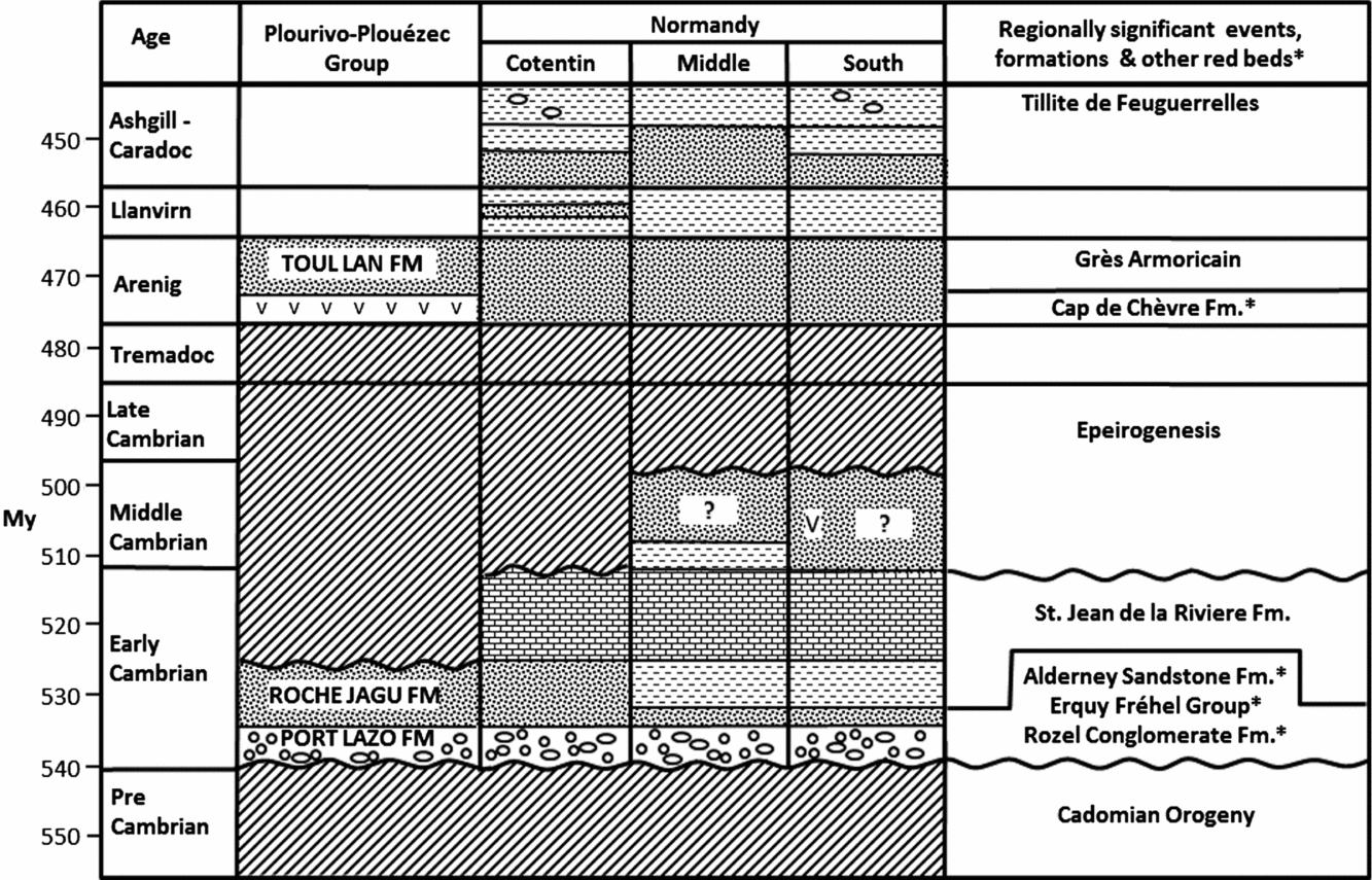
On the basis of the sedimentology and field observations, the lower Palaeozoic basin fill of Plourivo-Plouézec is interpreted to comprise strata of both early Cambrian and Early Ordovician age. The Port Lazo and Roche Jagu formations are interpreted to be Lower Cambrian in age. An unconformity is believed to separate these older formations from the andesites and the Toul Lan Formation, which are interpreted to be Early Ordovician (Arenig) in age. This interpretation is summarized in the Wheeler diagram in Figure 16. The reasoning behind this interpretation is discussed further below.
Interpretation of the chronostratigraphy of the Plourivo-Plouézec Group and relationship to other regionally significant events and formations.

The angular unconformity between the Port Lazo Formation and the underlying Brioverian metasediments is readily observable and indisputable. The deformation of the late Precambrian metasediments is attributed to the end Precambrian, Cadomian Orogeny which climaxed at c. 540 Ma (Peucat, Reference Peucat1986). This places a maximum age limit on the Port Lazo Formation.
The Port Lazo Formation lower member is up to 130 m thick and records deposition in an alluvial fan to alluvial plain environment of deposition. Deposition within an intermontane, early post-orogenic, extensional basin is consistent with this alluvial fan depositional setting. The succeeding sediments of the Port Lazo Formation upper member are unambiguously subaqueous in origin and point to a rise in base level, consistent with deposition following a marine transgression. The sand-dominated nature of the Port Lazo Formation upper member furthermore emphasizes the abundant supply of arenaceous sediment from nearby upland drainage basins.
The restriction of faunal evidence to localized occurrences of the enigmatic Ediacaran – early Cambrian impression fossil Arumberia, found in the Port Lazo Formation lower and upper members, might be used to suggest the sediments pre-date the radiation of Cambrian life and are therefore either very latest Precambrian or earliest Cambrian in age (c. 540 Ma). Arumberia is recognized as a fossil organism adapted to mixed salinity and periodically desiccated environments (Kumar & Pandey, Reference Kumar and Pandey2009; Kolesnikov, Grazhdankin & Maslov, Reference Kolesnikov, Grazhdankin and Maslov2012). It was initially believed to be restricted to the late Precambrian, Vendian period (Glaessner & Walter, Reference Glaessner and Walter1975) but more recent discoveries indicate its range extends into early Cambrian time (Bland, Reference Bland1984). It is a somewhat controversial fossil, with a non-biogenic origin even being proposed by McIlroy & Walter (Reference McIlroy and Walter1997). However, despite much searching, Arumberia is not known to exist after early Cambrian time. Despite its uncertain biological affinity it is still believed to have value as an age indicator and, in this case, is consistent with the suggested early Cambrian age.
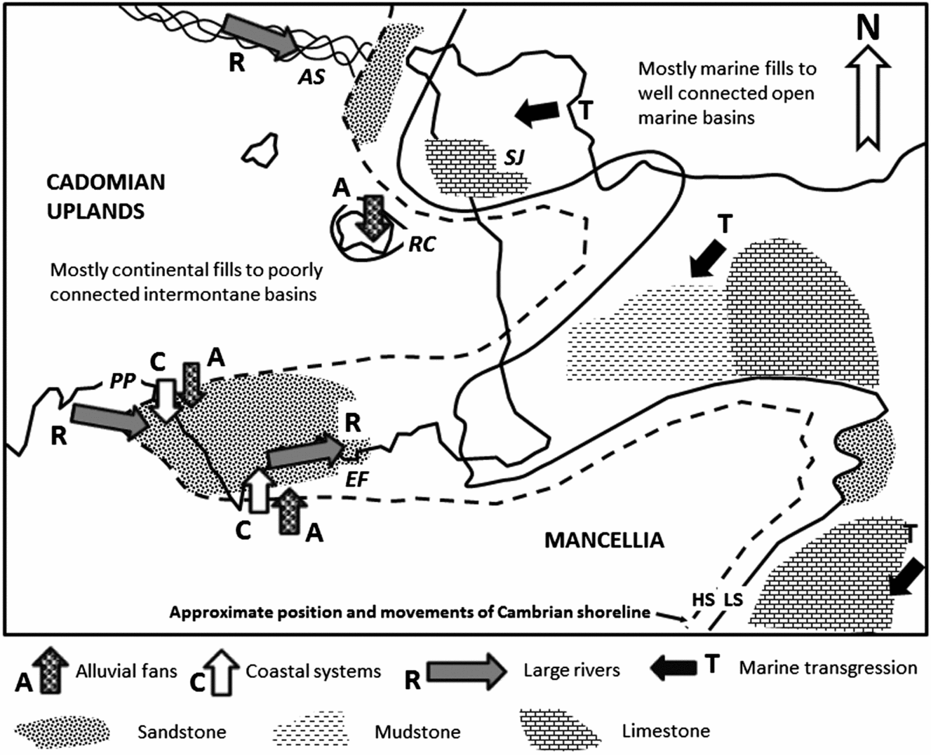
Discounting the presence of Arumberia, a somewhat younger age could be considered if the environment was non-marine or severely stressed, thereby inhibiting colonization (cf. Suire, Dabard & Chauvel, Reference Suire, Dabard and Chauvel1991; Egal et al. Reference Egal, Le Goff, Guennoc, Lebret, Thiéblemont, Hallégouët, Houlgatte, Callier and Carn1995). A non-marine environment is not excluded, since basinal processes appear to have been of low energy. However, if the evidence for tides is accepted, then the basinal waters must have been open marine since tides are not known to be effective in lakes. It is considered plausible that common outpourings of fresh water and sediment from river floods entering a restricted marine environment (Fig. 17) made it sufficiently stressed to inhibit habitation (cf. Jackson et al. Reference Jackson, Larsen, Hanslien and Tjensland2011).
Proposed early Cambrian palaeogeography: PP – Plourivo-Plouézec; EF – Erquy Fréhel; RC – Rozel Conglomerate; AS – Alderney Sandstone; SJ – St Jean de la Riviere.

An upper age for the Port Lazo and Roche Jagu formations is provided by the relationship and dating of the andesites that occur associated with the Plourivo-Plouézec Group sedimentary strata. The detailed evaluation of field relationships observed around the coast indicates that the andesites are a mixture of extrusive lavas and commonly substantial, intrusive bodies. The lavas exclusively overly the Roche Jagu Formation with several metres of relief present on what looks like an unconformity, albeit one with no great angular discordance. Other andesite bodies are intrusive into and post-date the Port Lazo and Roche Jagu formations. The lavas and intrusions are petrographically and chemically comparable and therefore believed to be related. A mixture of the lavas and the intrusions has been used as samples in the dating of the andesites (Auvray et al. Reference Auvray, Mace, Vidal and Van Der Voo1980). They have been dated using the Rb/Sr method, yielding a good isochron and date of 472±5 Ma (Arenig). This was interpreted by Auvray et al. (Reference Auvray, Mace, Vidal and Van Der Voo1980) as reflecting an age of eruption. Despite a number of reservations, the interpretation of this age date seems reasonable and places an upper limit on the age of the Port Lazo and Roche Jagu formations. It also places a lower limit on the age of the Toul Lan Formation which succeeds the andesite and is not intruded by it (Egal et al. Reference Egal, Le Goff, Guennoc, Lebret, Thiéblemont, Hallégouët, Houlgatte, Callier and Carn1995).
Palaeogeographic reconstructions also need to be considered in support of an age proposal (Fig. 17). The fossiliferous lower Cambrian strata in Normandy led Doré (Reference Doré1972, Reference Doré, Chantraine, Rolet, Santallier, Piqué and Kleppie1994) and Doré et al. (Reference Doré, Juignet, Larsonneur, Pareyn and Rioult1977) to propose a sinuous early Cambrian shoreline separating marine Cambrian in the east from an exposed area over northern Brittany in the west. Went & Andrews (Reference Went, Andrews, D'Lemos, Strachan and Topley1990) proposed that the fluvially dominated Alderney Sandstone Formation and Erquy-Fréhel Group sediments were also probably Cambrian in age, and that the marine Cambrian basins of Normandy extended westwards into northern Brittany but with fills largely of continental strata. This western area was generally an intermontane basin region but was still connected to the marine environment, albeit through relatively narrow seaways. The Port Lazo and Roche Jagu formations of the Plourivo-Plouézec Group share some similarities with the strata exposed in Erquy. This is perhaps not so surprising since they are relatively close geographically. One feature of the Alderney Sandstone and Fréhel Formation sandstones is that they were clearly deposited by moderately large rivers that drained east to the early Cambrian shoreline (Fig. 17). The facies, palaeocurrents and palaeohydraulic characteristics of the Roche Jagu Formation sandstones are closely comparable to those seen in Alderney and at Erquy (Went & Andrews, Reference Went, Andrews, D'Lemos, Strachan and Topley1990, Reference Went and Andrews1991; Todd & Went, Reference Todd and Went1991). It is proposed that each records a moderately large river, draining east to an early Cambrian shoreline that oscillated somewhat around a N–S-aligned line in western Normandy (Fig. 17). In central and northern Normandy the lower Cambrian sequence is transgressive. This cannot be demonstrated categorically in Plouézec, Erquy or Alderney since continental sediments dominate. Marine intervals are however present in each of the above sequences, suggesting a connection to the sea (Went, Reference Went2013). The marine Erquy Quartzite and the Bluestone Bay Sandstone sequence in Alderney may actually correlate with the Port Lazo Formation upper member. This cannot be asserted with confidence since there is a difference in facies, but it is a possibility. On the other hand, local tectonic controls on basin subsidence may have determined that multiple, non-synchronous marine incursions affected these basins. While the large trunk rivers drained east parallel to the structural grain, lateral systems, typically either alluvial fans or coastal facies, fed the basin from the north or south. In Erquy the alluvial fan systems drained north, whereas in Plouézec they evidently drained south. It is proposed that this is because they were on opposite sides of the depositional basin. Likewise, the nearshore sandstones in Erquy show N-oriented (ebb-dominated) palaeocurrents interpreted to reflect an E–W-oriented strandline, whereas in Plouézec the river-flood-dominated delta shed hyperpycnal flows southwards. This palaeogeographic interpretation is captured in Figure 17.
The Cambrian sequences in northern Normandy are exclusively of early Cambrian age. The Cambrian strata in central and southern Normandy may extend into the middle Cambrian period. A period of regional upwarping (epeirogenesis) during middle and late Cambrian time, extending through to the earliest Arenig, affected Normandy and Brittany. During the Arenig, subsidence was renewed and shallow-water sandstones (Grès Armoricain) and shales were deposited across all Normandy and Brittany. In Brittany, a phase of Arenig-aged red-bed deposition locally preceded deposition of the Grès Armoricain (Bonjour et al. Reference Bonjour, Peucat, Chauvel, Paris and Cornichet1988). The andesites in Plouézec are dated as Arenig in age. They are believed to have formed during broadly the same phase of crustal extension that was responsible for the volcanic rocks interbedded with the Grès Armoricain in Crozon (Bonjour et al. Reference Bonjour, Peucat, Chauvel, Paris and Cornichet1988). The Toul Lan Formation shares some similarities with the Grès Armoricain and is interpreted to have been deposited very soon after eruption of the andesitic lavas, also in the Arenig. This renewed phase of crustal extension during Early Ordovician time is related to the opening of the Rheic Ocean (Robardet, Paris & Racheboeuf, Reference Robardet, Paris, Racheboeuf, McKerrow and Scotese1990).
Although the facies of Port Lazo Formation lower member and the Roche Jagu Formation share features in common with the continental clastic deposits of the Rozel Conglomerate, Alderney Sandstone and Erquy-Fréhel formations, there are also some differences. The Port Lazo Formation lower member contains a significant volume of red mudstone, unlike the other localities. Pre-vegetation rivers tended to be braided in character (Davies & Gibling, Reference Davies and Gibling2010; Davies, Gibling & Rygel, Reference Davies, Gibling and Rygel2011). However, in the lower coastal reaches of the mud-prone alluvial plain in Plourivo-Plouézec, there is evidence for laterally migrating, single-thread, sinuous channels. These channels carried a very fine bedload and may have been tidally influenced. Nevertheless, they confirm that not all channels on pre-vegetation alluvial plains were braided (Santos & Owen, Reference Santos and Owen2016).
The facies of the subtidal Port Lazo Formation upper member also contrast with the nearshore marine facies observed at Erquy and in Alderney which are quartzites (Went, Reference Went2013). Perhaps the main reason for the marked contrast in coastal processes operating in Plourivo-Plouézec compared with Erquy and Alderney was the difference in the grade of the sediment supplied to the shoreline. During deposition of the Port Lazo Formation upper member, rivers delivered fine-grained muddy sand to the shoreline, whereas in Erquy and Alderney the rivers supplied very-coarse-grained sand. The fine grade of the material allowed turbulent suspensions to develop at river mouths in Plourivo-Plouézec but not in Erquy or Alderney, where coarse sands dictated that coastal facies were dominated by bedload processes (Went, Reference Went2013). Many early Palaeozoic rivers were characterized by large floods, a property well suited to the formation of hyperpycnal flows. However, not all rivers carried a sediment load that was suited to their development.
8. Conclusions
The deposits of the Port Lazo and Roche Jagu formations of the Plourivo-Plouézec Group represent deposition in three separate depositional systems. The Port Lazo Formation lower member is composed of conglomerates, cross-bedded sandstones and mudstones and records deposition in a southwards-building alluvial fan to lower alluvial plain setting. The Port Lazo Formation upper member is composed of fine-grained massive sandstones, ripple cross-laminated sandstones and subordinate mudstones, and records deposition in a tide- and wave-influenced, but river-flood-dominated, subtidal environment. Sedimentation was dominated by river-flood-generated, southwards-flowing, shallow-water turbidity currents (hyperpycnites). The Roche Jagu Formation comprises cross-bedded sandstones and subordinate mudstone, and records deposition in a moderately large, eastwards-flowing, braided river environment.
Andesitic lavas rest on the Roche Jagu Formation via a prominent erosion surface identified as an unconformity. Andesites interbedded with the sedimentary rocks of the Roche Jagu Formation are intrusions. The andesites, dated at 472±5 Ma, therefore post-date deposition of the Port Lazo and Roche Jagu formations, and pre-date the Toul Lan Formation. The relationship to the andesites, the presence of the Ediacaran – early Cambrian impression fossil Arumberia and regional correlations of facies all suggest the Port Lazo and Roche Jagu formations are early Cambrian in age and relate to a phase of early post-orogenic sedimentation in extensional basins. The andesites and Toul Lan Formation are interpreted as Early Ordovician in age, and relate to a renewed phase of extension associated with the opening of the Rheic ocean in the Arenig.
The Port Lazo and Roche Jagu formations accumulated in an intermontane basin where rivers supplied fine-grained sand and mud to the shoreline. The sediment calibre was a significant control on the sedimentary facies. The mud-prone alluvial plain was crossed, at least in part, by meandering channels, uncommon during early Palaeozoic time, and hyperpycnites dominated sedimentation in the nearshore coastal zone.
Acknowledgements
Thanks are extended to the editor and to the referees, Alessandro Ielpi and Piret Plink-Bjorkland, for constructive reviews that helped to significantly improve the final script. Thanks also to Neil Davies and Will McMahon for discussions on the enigmatic Arumberia. This research received no specific grant from any funding agency, commercial or not-for-profit sectors.