


Introduction
Migratory landbirds are among the most threatened bird groups in the world (Bairlein Reference Bairlein2016). They face multiple risks from global change (Zurell et al. Reference Zurell, Graham, Gallien, Thuiller and Zimmermann2018) and local processes along the different stages of their annual cycle, both on their breeding and wintering grounds, and during migration. Birds are often well studied on their breeding grounds, but their movements away from the breeding grounds are generally less well known (Marra et al. Reference Marra, Cohen, Loss, Rutter and Tonra2015; Vickery et al. Reference Vickery, Mallord, Adams, Beresford, Both and Cresswell2023). Therefore, identifying migratory routes and stopover sites, and the risks posed to migratory birds at these locations, can make an important contribution to their conservation. A better understanding of migratory movements, including crossings of ecological barriers such as open water and desert (Dufour et al. Reference Dufour, Nussbaumer, Briedis, Bocher, Conway and Coulomb2026), and stopover use, may help to identify areas where they are most at risk and promote better protection during the entire annual cycle.
The European Turtle-dove Streptopelia turtur (turtle-dove hereafter) is a migratory landbird that breeds across much of the Western Palearctic and into Central Asia, and winters across the Sahel zone in sub-Saharan Africa. It is classified by the IUCN as Vulnerable due to large-scale population decline, caused by habitat loss and degradation, disease and hunting, the last of which occurs mainly along migration routes and at stopover sites (Baptista et al. Reference Baptista, Trail, Horblit, Boesman, Sharpe and Kirwan2020; BirdLife International 2019). Among the identified threats to the species, Fisher et al. (Reference Fisher, Ashpole, Scallan, Proud and Carboneras2018) identified the loss of high-quality habitats for breeding, and the loss of productive habitats for stopover and wintering, as the most important. Hunting was highly unsustainable across Europe (Lormée et al. Reference Lormée, Barbraud, Peach, Carboneras, Lebreton and Moreno-Zarate2020; Carboneras et al. Reference Carboneras, Šilarová, Škorpilová and Arroyo2024), while illegal killing was also identified as critical, with some 600,000 turtle-doves estimated to be killed illegally across the Mediterranean Basin annually (Brochet et al. Reference Brochet, Van Den Bossche, Jbour, Ndang’ang’a, Jones and Abdou2016). Breeding phenology, migration routes, stopover sites and winter quarters, and corresponding habitat uses have all been documented for turtle-doves breeding in western and central Europe and using a westerly migration route to Africa (Eraud et al. Reference Eraud, Rivière, Lormée, Fox, Ducamp and Boutin2013; Lormée et al. Reference Lormée, Boutin, Pinaud, Bidault and Eraud2016; Marx et al. Reference Marx, Korner-Nievergelt and Quillfeldt2016; Ren et al. Reference Ren, Princé, Bocher, Champagnon, Duriez and Jiguet2025; Requena et al. Reference Requena, Lormée, Beresford, Buchanan and Eraud2025; Schumm et al. Reference Schumm, Metzger, Neuling, Austad, Galea and Barbara2021). Lormée and Carboneras (Reference Lormée and Carboneras2021) suggested that eastern European breeding populations use a flyway along the Levantine coast. Nevertheless, the migration behaviour of the turtle-dove populations using the East Mediterranean–East African flyway has not been studied before. This information is important for the global conservation of this threatened species, as a significant proportion of the global population uses the East Mediterranean–East African flyway (BirdLife International 2019; Fisher et al. Reference Fisher, Ashpole, Scallan, Proud and Carboneras2018). Multiple threats, including land-use changes and hunting (BirdLife International 2019), and potentially also development of infrastructure along their migration routes, threaten their survival and that of other migratory birds (Schuster et al. Reference Schuster, Bulling and Köppel2015; Smallwood and Thelander Reference Smallwood and Thelander2008). Identifying migration routes, important stopover sites and wintering areas is necessary to direct conservation efforts to areas of importance for the species.
Despite being globally threatened, the species can still be legally hunted in several countries along the East Mediterranean–East African flyway. In Israel, a temporary hunting ban has been in place since 2020, following the species’ classification in the national Red List as Near Threatened (Mayrose et al. Reference Mayrose, Labinger, Steinitz, Hatsofe, Haviv and Perlman2017). Recent studies have since reported a decline of 81% in turtle-dove numbers at monitored sites in Israel between 2012 and 2021 (Grossbard and Renan Reference Grossbard and Renan2024). The first temporary order was issued for one year by the Environmental Protection Minister, Gila Gamliel, and was then extended for a further three years by her successor, Tamar Zandberg. During this period, the Israel Nature and Parks Authority was tasked with conducting research on the status of the turtle-dove in Israel.
In this study, we aimed to document the migratory behaviour of turtle-doves along the East Mediterranean–East African flyway, based on birds tracked from Azerbaijan and Israel. We investigated migration timing and routes, identified important stopover sites and wintering areas, and considered possible causes of mortality. This information may improve understanding of the migratory behaviour of this threatened species and inform conservation policies along its flyway.
Methods
Tagging
In Azerbaijan, 10 turtle-doves were fitted with GPS tags between 9 and 13 July 2023 at Moranli (39.44° N, 48.41° E; see Supplementary material Table S1). Three different types of solar-powered tags were used: GPS-GSM Interrex Mini P1 2G tags (weighing 5 g each) for four birds, GNSS-GPS Hunan HQBG1204 (4.5 g) for four birds, and Argos-GPS Microsensory tags for two individuals (4 g). The birds were trapped using mist nets. The age of the individuals was determined from plumage characteristics; the sample comprised one adult (Hunan tag) and nine juveniles. The tags were attached using individually adjusted wing-loop backpack harnesses made from 1.5-mm-wide silicone tubing (RCT®-DKA-795, RCT Reichelt Chemietechnik GmbH + Co., Heidelberg, Germany).
In Israel, 16 birds (four in 2022, 12 in 2023; 12 birds in their first calendar year, four adults; see Supplementary material Table S1) were fitted with Interrex Mini M1 tags (5 g). The reason for tagging both juvenile and adult birds was to obtain a more representative sample of the population’s migratory routes, assuming possible age-related differences (Efrat et al. Reference Efrat, Lehnardt, Bragin, Bragin, Avgar and Katzner2025). Tracking mostly juveniles was intended to ensure their representation in the data, as juvenile survival is expected to be much lower than that of adult birds. The tags were attached using bespoke Teflon backpack straps supplied by the manufacturer. The birds were trapped using mist nets in the Bet Shean Valley in northern Israel (32.40° N, 35.52° E) during the first half of September, when there are large turtle-dove concentrations in this region. At the time of trapping, it was unclear whether the birds present belonged to migrant populations originating from breeding areas further north, or local breeding populations.
Data collected by the tags included GPS fixes, speed, and altitude above sea level, with varying sampling frequency depending on battery charge. The total maximum weight of individual equipment, including the mandatory metal identification ring, GPS device, and harness, was 6 g. This corresponded to 4.5% of the birds’ mean body mass (132 g), ranging from 3.6% to 5.2% across the 26 individuals, which is similar to values reported in previous studies: Ren et al. (Reference Ren, Princé, Bocher, Champagnon, Duriez and Jiguet2025) (Interrex Mini and Ornitela OT-6 tags), Barboutis et al. (Reference Barboutis, Bounas, Navarrete and Fransson2023) (including GPS Argos solar tags of 5.5 g) and Schumm et al. (Reference Schumm, Metzger, Neuling, Austad, Galea and Barbara2021) (including 5 g solar PTT).
We also documented technical failures for some tags. For example, among tags deployed in Israel, tag 0A5B (bird ID2) was still connecting and transmitting accelerometer data, indicating that it was still active on 11 January 2026, although it had not recorded or transmitted GPS locations since 29 April 2024. Tag 0A33 (bird ID9) connected until 28 May 2025, but stopped recording GPS positions on 24 April 2024. Furthermore, turtle-doves tagged in Bahrain with similar Interrex tags apparently removed their GPS antennas and then stopped transmitting locations (photographic evidence; M. J. McGrady, pers. comm.). Thus, the loss of turtle-doves from tracking records may in some cases reflect a technical failure of the tracking technology, although this cannot be confirmed.
Data handling
To study the migratory phenology and characteristics of the tagged turtle-doves, we first selected accurate GPS fixes. We filtered outliers from our GPS data in two stages: 1) we visually identified and excluded spoofed GPS locations, which at the time of the study were few and clearly recognised (Jiguet et al. Reference Jiguet, Mayrose, Piha, Efrat, Seimola and Sapir2025); 2) we calculated speed and turn angle between each pair of GPS locations and removed locations above the 98th percentile, assuming that these were erroneous. We aimed to gain insights into the migration of the turtle-doves using three metrics: daily progress, maximum flight durations, and flight altitude. For daily progress, we used a single GPS location per day. Because we assumed that most migration occurs at night, we kept only the location closest to noon on each tracking day, with noon calculated using the suncalc R package (Thieurmel and Elmarhraoui Reference Thieurmel and Elmarhraoui2019). Noon was chosen because turtle-doves are predominantly nocturnal migrants (Lormée et al. Reference Lormée, Boutin, Pinaud, Bidault and Eraud2016; Dufour et al. Reference Dufour, Nussbaumer, Briedis, Bocher, Conway and Coulomb2026). Following visual examination of the birds’ movements, we noticed that the transition from sedentary behaviour to directional migration occurred when birds travelled more than 30 km in 24 h. Therefore, we defined a migratory day as one on which a turtle-dove moved more than 30 km in the migratory direction (south in autumn and north in spring) within 24 h. Consequently, stopovers were defined as periods of at least 24 h during which a bird moved less than 30 km in the migratory direction (Schmaljohann et al. Reference Schmaljohann, Eikenaar and Sapir2022). We then calculated mean departure date and daily migration distance and counted the number of migration days for all turtle-doves for which we had migration tracking data. We also separately calculated the mean daily migration distance for the first day of migration, because that day had the largest sample size. For the turtle-doves for which we obtained complete autumn migration tracks, we calculated the total migration distance. To calculate maximum flight duration, we used all data and assumed that a turtle-dove was in flight if the GPS speed was greater than 2 ms-1. We considered a flight as continuous if all consecutive GPS locations were in flight, and the time between locations was less than 2 h. Finally, for all 1,722 locations in flight during migration, we calculated the height above ground level. To do this, we first filtered the height above sea level received from the GPS transmitters to avoid large errors, removing altitudes above 2,000 m or below -1,000 m (five and seven locations, respectively). We then downloaded ground elevation height data using the elevatr R package (Hollister and Shah Reference Hollister and Shah2017) at a resolution of c.110 m for every location, and subtracted this elevation from the height above sea level received from the transmitters. Finally, we calculated the mean ± SD separately for locations of all flights over land (1,670 locations) and over water (40 locations) (whilst 12 locations situated at the interface between land and sea have not been allocated).
The tracking data of birds tagged in Azerbaijan, obtained with various tracking technologies, included major gaps, often failing to record locations for 10–12 h. Thus, the migratory information for turtle-doves tagged in Azerbaijan is less accurate than that for turtle-doves tagged in Israel, which usually had no daily gaps longer than 1 h, and only one migratory day had a single two-hour gap. For that reason, we do not report exact total durations or distances for continuous flights, retaining only daily-scale data. The three juveniles tagged in Azerbaijan initiated migration (see below) and made long (>30 km per 24 h) movements by the end of July, which made it challenging to define the initiation of migration. Following thorough examination of the data, we identified 39° N as a threshold for migration, because for all birds tagged in Azerbaijan, once they crossed that line to the south, they did not return north. Tracks recorded south of 39° N were defined as migratory or stopover using the same method described above, with the threshold being 30 km per 24 h.
Data handling and analyses were conducted using R (R Core Team Reference Team2021). Land uses at stopover sites and on wintering grounds were assessed visually using Google Earth imagery.
Results
Tracking summary
Of the 26 turtle-doves tagged, autumn migration was identified for 16: four tagged in Azerbaijan (the only adult and three juveniles) and 12 tagged in Israel (four in 2022 and eight in 2023; Figure 2a). The latter comprised four adults and eight of the 12 tagged juveniles. We identified migration in two more juveniles tagged in Azerbaijan, though their tags did not record GPS locations. These two Interrex tags (ID20 and ID21) reported the locations of GSM antennas to which they connected, confirming migratory movements.
The turtle-doves were tracked for 1–49 days (10.5 ± 13.8, mean ± SD) between the first and last days of recorded autumn migration: 1–21 days (11.3 ± 8.3) and 1–49 days (10.3 ± 15.7) for birds tagged in Azerbaijan and Israel, respectively. Active migration (>30 km within 24 h) was recorded on 1–9 days (3.6 ± 2.23): 1–7 days (3.75 ± 2.5) for birds tagged in Azerbaijan and 1–9 days (3.6 ± 2.3) for birds tagged in Israel.
Migration overview
Migration began before dusk, and most flights were nocturnal. The last recorded locations for turtle-doves tagged in Azerbaijan were in Iran (ID19), Iraq (ID24 and ID26), Saudi Arabia (ID20 and ID21) and in northern Sudan (ID23) (Figure 1). The adult turtle-dove that flew all the way to Sudan crossed the Red Sea, flying a minimum of 170 km over open water before reaching Africa (the temporal resolution of the data precluded certainty about its exact route over the water). This bird then continued over the Sahara Desert for 500 km until it reached the Nile River in Sudan (Figure 1). No wintering locations or spring migrations were recorded.
Migration tracks of 8 European Turtle-doves Streptopelia turtur tagged in Azerbaijan (July 2023) and Israel (September 2022 and 2023); ringing sites are shown with black triangles. Colours represent different individuals. Circles represent stopovers lasting 24 h or more; circle size is proportional to stopover duration, except for two individuals tagged in Azerbaijan who connected to geolocated GSM antennas but did not send GPS locations. Dashed blue line is the Nile River. Green and blue represent IDs 7 and 9 in Supplementary material Table S1, which completed full migration cycles. Migration onset was defined as the first day with directional southward movement of >30 km in 24 h, or the crossing of 39° N for birds tagged in Azerbaijan; accordingly, migration and stopover days were defined as days with >30 km or <30 km movements in 24 h, respectively (see Methods).

Figure 1. Long description
A geographical map of the Middle East and Northeast Africa with a coordinate grid.
* Ringing Sites: Marked with black triangles in Azerbaijan (Northeast) and Israel (West).
* Migration Routes:
- Birds from Azerbaijan (IDs 7 and 9, shown in green and blue) travel Southwest through Iran, Iraq, and Saudi Arabia, crossing the Red Sea into Sudan and Ethiopia.
- Other tracks from Azerbaijan (brown, purple, yellow, pink) show varied paths across the Arabian Peninsula, with some ending at dashed circles labeled Estimated location in Saudi Arabia and Iraq.
- Birds from Israel travel South along the Nile River valley into Egypt and Sudan.
* Stopovers and Wintering:
- Circles along the paths indicate stopovers, with larger diameters representing longer durations (up to greater than 25 days). Significant stopover clusters are visible in the Nile Delta and central Sudan.
- Black X marks indicate wintering sites in Southern Sudan and Ethiopia.
* Geographical Features: The Nile River is indicated by a dashed blue line. Countries labeled include Turkey, Georgia, Armenia, Azerbaijan, Iran, Syria, Lebanon, Israel, Jordan, Iraq, Saudi Arabia, Egypt, Sudan, Eritrea, Ethiopia, and Chad.
* Scale and Orientation: A north arrow is at the top center. A scale bar at the bottom left indicates 0 to 400 km.
Migration tracks of 10 European Turtle-doves Streptopelia turtur tagged in Israel in September 2022 and 2023. The ringing site is shown with a black triangle. Colours represent different individuals. (a) The full autumn migration tracks of ten birds tagged in Israel, including sea and desert crossings. (b) Migration tracks of the same ten birds are shown during their first days of migration along the Great Rift Valley, including flights over the Dead Sea.

Figure 2. Long description
A two-panel map set with a legend and scale bars.
Panel A (Left): A large-scale map of the Eastern Mediterranean and Northeast Africa. A black triangle marks the ringing site in Northern Israel. Ten colored lines (purple, green, yellow, and blue shades) originate from this point, traveling South through Jordan and Saudi Arabia. Most tracks cross the Red Sea into Egypt. Large circles on the tracks indicate stopover durations, with the largest circles representing over 25 days, concentrated in Southern Egypt. A dashed blue line marks a western boundary in Egypt. The X-axis ranges from 30 degrees East to 36 degrees East, and the Y-axis from 24 degrees North to 32 degrees North.
Panel B (Right): A high-resolution inset of the initial migration stage. The tracks are tightly clustered, moving South from the black triangle ringing site at approximately 32.5 degrees North. The paths follow the Great Rift Valley, passing directly over and along the eastern shore of the Dead Sea. The X-axis ranges from 35.0 degrees East to 35.5 degrees East, and the Y-axis from 31.0 degrees North to 32.5 degrees North.
The legend in the top left defines the black triangle as the Ringing Site and provides a scale for ‘Days In Stop Over’ using six graduated circle sizes from 0 to greater than 25. Scale bars indicate 200 kilometers for Panel A and 30 kilometers for Panel B.
For turtle-doves tagged in Israel, in 2022, the four tagged turtle-doves, three young birds and one adult, were recorded setting off on migration south along the Great Rift Valley. Their last recorded locations were in southern Israel (IDs 13 and 14 in Table S1), the east coast of the Red Sea in Saudi Arabia (ID15), and southern Sinai Peninsula (ID16). In 2023, eight (five juveniles and three adults) of the 12 tagged birds were recorded setting off on migration using a similar route along the Great Rift Valley as those that migrated in 2022 (Figure 2b). Two birds followed the eastern shores of the Gulf of Aqaba, while six birds followed the western shores. Six birds crossed the Red Sea southwest of the Gulf of Aqaba, flying 100–345 km over open water. One bird (ID7) appeared to fly non-stop over water from the northernmost point of the Gulf of Aqaba. This suggests that this turtle-dove flew c.385 km over open water, yet the temporal resolution of the data does not allow us to be certain about the exact flight locations during the crossing of the Gulf of Aqaba. After short rests close to the western shore of the Red Sea in Egypt, four birds continued inland and headed towards the Nile River, between the cities of Aswan and Luxor in Egypt, a flight of approximately 150 km over desert. These birds then stopped over in cultivated areas along the Nile River between Luxor and Aswan. The final location of three individuals (IDs 1, 3 and 12) was recorded in cultivated land along the Nile River. The final location of another individual (ID11) was along the Red Sea coast in Egypt, shortly after it had completed its sea crossing (Figure 2).
Complete wintering tracks were recorded for two individuals (Figure 1). ID7, an adult bird, continued south from its stopover site along the Nile in Egypt between Luxor and Aswan on 15 October 2023, flying another 1,600 km along the Nile. It spent over two months in southern Sudan, then on 17 January 2024, it moved another 100 km southeast and spent the rest of the winter in northern South Sudan (9.94° N, 30.20° E), flying short distances daily between presumed foraging and roost sites in a landscape comprising an apparent mosaic of acacia savanna and farmland. It was recorded setting off on migration north on 28 March 2024, following a similar route to its southward migration. It stopped over twice on its way north: between 29 March and 2 May 2024 in open desert with scattered bushes west of the Nile in southern Sudan, and again in cultivated land along the Nile north of Aswan, Egypt, between 7 and 27 May 2024. ID9, a juvenile bird, followed a more easterly route in its southward migration. After crossing the Red Sea, it continued flying south over desert for approximately 730 km farther, reaching the Nile River in northern Sudan. On 7 November 2023, it continued heading south along the Nile for another 500 km and stayed in cultivated land along the Nile 180 km south of Khartoum, Sudan, until 20 December 2023. It is unknown where it spent the rest of winter 2023/24. It was picked up again transmitting in autumn 2024. On 30 October 2024, it sent locations along the Nile in Khartoum, Sudan. It spent winter 2024/25 in a region of cultivated land along the Nile north of Khartoum. Its final location was sent on 29 April 2025, about 150 km north of Khartoum, where it disappeared.
These birds (ID7 and ID9) were also tracked in northern Israel in spring and summer 2024. However, because of GNSS spoofing (Jiguet et al. Reference Jiguet, Mayrose, Piha, Efrat, Seimola and Sapir2025), it was impossible to determine their exact locations. Both birds spent summer 2024 along the Jordan River, in the vicinity of where they had been tagged, and may have bred there. A third bird (ID2, juvenile) possibly survived its southward migration in autumn 2023 and the winter season of 2023/24. It was recorded beginning migration south on 30 September 2023. It migrated 160 km and stopped over in the southern Dead Sea region in Israel, after which it did not send any more locations for the rest of its autumn migration and winter period. It was picked up again sending spoofed GNSS locations in late April 2024, but continued to connect to GSM towers in southern Sinai for almost a year, suggesting that it may have died in that area around that time. It is unknown where it had spent winter 2023/24.
Flight details
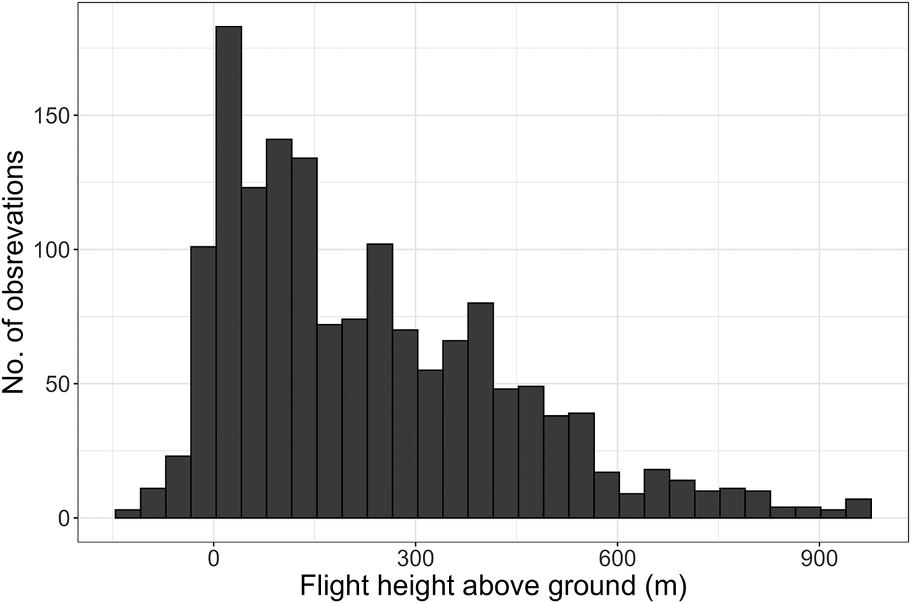
Flight details of birds tagged in Israel and Azerbaijan are summarised in Table 1. Mean autumn migration departure date was 13 September ± 12.4 days (range 28 August to 23 September) and 30 September ± 5.5 days (range 21 September to 8 October) for birds tagged in Azerbaijan and Israel, respectively. During active migration days, the turtle-doves covered a daily distance of 271 ± 203 km (range 32.5–752 km); 328 ± 203 km (range 43.5–752 km) and 249 ± 201 km (range 32.5–704 km) for birds tagged in Azerbaijan and Israel, respectively. During the first day of migration, the turtle-doves covered 212 ± 166 km (range 63.9–704 km); 238 ± 93 km (range 153–362 km) and 203 ± 188 km (range 63.9–704 km) for birds tagged in Azerbaijan and Israel, respectively. Continuous flights were calculated only for turtle-doves tagged in Israel, due to large gaps in location acquisition for turtle-doves tagged in Azerbaijan. Continuous flights lasted 0.8–13 h, covering 33.4–719 km, with the two longest flights lasting 11 and 13 h and covering 713 and 719 km, respectively, flying over the Gulf of Aqaba and crossing the Red Sea and desert. Flight altitudes were 241 ± 286 m above ground level: 160 ± 383 m and 251 ± 270 m for birds tagged in Azerbaijan and Israel, respectively. Flights above water were only detected for turtle-doves tagged in Israel, with a mean altitude of 255 ± 217 m above water (Figure 3).
Flight details of European Turtle-doves tagged in Israel and Azerbaijan in 2022 and 2023.

Table 1. Long description
The table consists of eight columns and two data rows.
Column headers from left to right are: Migration metrics, Migration onset date (mean plus or minus S D days), Number of days tracked during active migration (greater than 30 km within 24 h, mean plus or minus S D), Mean daily distance covered (km, mean plus or minus S D, range), Distance covered on first day of migration (km, mean plus or minus S D, range), Total migration distance (n = 2; km, range), Flight altitude above ground (m, mean plus or minus S D), and Flight altitude above water (m, mean plus or minus S D).
Row 1: Azerbaijan (n = 4).
- Migration onset: 13 September plus or minus 12.4 days.
- Days tracked: 1 to 7 (3.75 plus or minus 2.5).
- Mean daily distance: 328 plus or minus 203 (43.5 to 752).
- First day distance: 238 plus or minus 93 (153 to 362).
- Flight altitude above ground: 160 plus or minus 383.
- Total distance and altitude above water are blank.
Row 2: Israel (n = 12).
- Migration onset: 30 September plus or minus 5.5 days.
- Days tracked: 1 to 9 (3.6 plus or minus 2.3).
- Mean daily distance: 249 plus or minus 201 (32.5 to 704).
- First day distance: 203 plus or minus 188 (63.9 to 704).
- Total migration distance: 2,050 to 2,516.
- Flight altitude above ground: 251 plus or minus 270.
- Flight altitude above water: 255 plus or minus 217.
Flight height above ground during active migration for 16 tracked European Turtle-doves Streptopelia turtur tagged in Azerbaijan and Israel. The data shown here represent the central 95% of the distribution, i.e., between the 2.5th and 97.5th percentiles.

Figure 3. Long description
The horizontal X-axis is labeled Flight height above ground m with major tick marks at 0, 300, 600, and 900. The vertical Y-axis is labeled No. of observations with tick marks at 0, 50, 100, and 150.
Data distribution:
* The histogram shows a strong right-skewed distribution.
* The highest frequency peak occurs just above 0 meters, reaching nearly 180 observations.
* A secondary, lower peak occurs around 250 meters with approximately 100 observations.
* A third minor peak is visible near 400 meters with about 80 observations.
* Beyond 600 meters, the number of observations drops significantly, tapering off toward 900 meters with very low frequencies per bin.
* A small number of observations are recorded slightly below the 0-meter mark on the X-axis.
For the two turtle-doves for which complete autumn migration tracking data were obtained (ID7 and ID9), the migration duration was 32 and 49 days, actively migrating during six and nine days and covering 2,050 and 2,516 km, respectively.
Discussion
Detailed knowledge of the migration of turtle-doves from the East Mediterranean–East African flyway remains limited (Bankovics Reference Bankovics2001; Fisher et al. Reference Fisher, Ashpole, Scallan, Proud and Carboneras2018) and this study provides the first details on the southbound migration of turtle-doves tracked from Azerbaijan and Israel to north-east Africa, along the flyway. Turtle-doves tagged in Azerbaijan and Israel migrated south or south-west in autumn. Their recorded routes converged in north-eastern Africa along the Nile River, and the birds overwintered in Sudan and South Sudan. During migration, the tagged birds crossed ecological barriers in long non-stop flights that included sea and desert crossings; some birds flew more than 340 km over open water, with continuous flights of up to 750 km. Turtle-doves tagged in Azerbaijan initiated migration considerably earlier than those tagged in Israel. Mean migration onset date was 13 September in Azerbaijan, compared with 30 September in Israel. While it is clear that turtle-doves tagged in Azerbaijan bred locally, it is not confirmed that all turtle-doves tagged in Israel belonged to the local breeding population and some may have been migrants. Therefore, these data cannot support broader ecological hypotheses about the relationship between breeding latitude and migration timing. Turtle-doves tagged both in Azerbaijan and in Israel flew at relatively low altitudes, with a mean of 160 m above ground in turtle-doves tagged in Azerbaijan, and 251 m above ground and 255 m above water during sea crossings in turtle-doves tagged in Israel. Too few turtle-doves tagged in Azerbaijan completed long migrations to allow comparison of flight details with turtle-doves tagged in Israel.
In general, previous studies have focused on turtle-doves using the East Atlantic flyway. Only three of the 26 tagged birds—one adult and two juveniles—were recorded returning north in spring; two were located close to their tagging sites, possibly close to their natal sites. Fidelity to breeding sites has been shown in adult turtle-doves in multiple studies, including in Malta (Schumm et al. Reference Schumm, Metzger, Neuling, Austad, Galea and Barbara2021) and France (Ren et al. Reference Ren, Princé, Bocher, Champagnon, Duriez and Jiguet2025). The observation of apparent natal-site philopatry by one juvenile turtle-dove (ID9) should be confirmed with larger samples.
All turtle-doves that were tracked during their southbound migration to northeastern Africa stopped over in cultivated land along the Nile River. Moreover, the three turtle-doves that were tracked to their actual or potential wintering grounds (ID7, ID9 and ID23) stopped over along the Nile River in Sudan. The adult turtle-dove (ID7) that was tracked on its northbound migration used similar stopover sites along the Nile. This information emphasises the importance of the Nile River and the cultivated land along it as a ‘green’ corridor across the vast desert belt of Sudan and Egypt (Noby et al. Reference Noby, Heitkönig, Bulte and Naguib2025).
Two of the eight turtle-doves tagged in Israel that migrated south in autumn along the shores of the Gulf of Aqaba flew along the east coast of the Gulf. Turtle-doves tagged in Azerbaijan moved to Iran and Iraq then across the Arabian Desert to reach the Red Sea shores. Relatively low flight altitudes, i.e. a mean flight altitude of 251 m above ground and 255 m above water (for turtle-doves tagged in Israel), combined with their migration routes, may expose them to collision with developing infrastructure along their journey. Importantly, the development of the giant city “The Line” in Saudi Arabia, which includes the planned construction of 500 m-tall glass structures, flanked by rows of wind turbines, extending 170 km from the Gulf of Aqaba coast inland, could create a substantial collision risk for turtle-doves and other migratory birds using this flyway. Further large wind-energy projects are planned by Saudi Arabia and Jordan along the Gulf of Aqaba east coast. This potential threat to turtle-doves and other migratory birds requires the immediate attention of conservation organisations and the implementation of mitigation measures to prevent mass collisions of migratory birds with planned infrastructure. Any development of wind energy facilities and other potentially harmful infrastructure along this migration flyway should consider the potential impact on migratory birds, especially globally threatened species such as the turtle-dove.
Recognition of the importance of cultivated land along the Nile as an important stopover region for turtle-doves, as indicated in this study, should prompt particular attention to the safety and functionality of the stopover sites for turtle-doves and other trans-Saharan migratory birds. Importantly, levels of illegal killing in Egypt are still high and have increased by 5–24% since 2020 (BirdLife International and EuroNatur 2025). Lake Burullus and Lake Nasser were identified by Brochet et al. (Reference Brochet, Van Den Bossche, Jbour, Ndang’ang’a, Jones and Abdou2016) as among the worst locations, with an estimated 428,000 and 225,000 birds, respectively, illegally killed or taken each year. However, levels of illegal killing of turtle-doves and other migratory birds are unknown in cultivated lands along the Nile in Egypt north of Lake Nasser, and in Sudan, used as stopover sites by turtle-doves tracked in this study. It is important to collect data on illegal killing of turtle-doves and other migratory birds in these regions to inform targeted conservation action there.
Detailed information on winter movements was available for only two individuals (ID7 and ID9). Turtle-doves tagged in the United Kingdom and France showed significant southward rainfall-related range shifts during winter (Lormée et al. Reference Lormée, Boutin, Pinaud, Bidault and Eraud2016; Requena et al. Reference Requena, Lormée, Beresford, Buchanan and Eraud2025). ID7 similarly moved south by only just over 100 km between its arrival on 13 November 2023 and its departure north on 28 March 2024. ID9 stayed locally in cultivated land along the Nile in Sudan all winter. More information is needed on the wintering site characteristics and intra-African movements of turtle-doves using the East Mediterranean–East African flyway, especially in relation to seasonal land-use changes and weather variability.
The data collected in this study have already helped to mitigate threats to the species in Israel. First, the return in summer 2024 of two birds tagged in autumn 2023 to the area where they had been tagged indicated that at least some of the turtle-doves present in northern Israel during September are likely local breeders. Second, the southward migration onset dates of the turtle-doves tagged in Israel extended well into October. These data supported an extension of the hunting ban in 2024 because the current hunting period (from 1 September) threatens both local breeders and migrants. Such a hunting ban can be effective in restoring turtle-dove populations (Carboneras et al. Reference Carboneras, Šilarová, Škorpilová and Arroyo2024).
All five adult turtle-doves survived until the start of post-breeding migration, and all five tags (100%) continued to transmit, while the tags of 10 of 21 juvenile turtle-doves (48%) stopped transmitting information before migration began (33% for juveniles tagged in September in Israel, 56% for juveniles tagged in July in Azerbaijan). Such a difference may reflect increased mortality (including predation) in young, inexperienced individuals (Jones et al. Reference Jones, Kaiser and Sillett2026). For example, Dunn et al. (Reference Dunn, Morris and Grice2016) found that survival in turtle-doves in the United Kingdom was only 0.429 in the first 35 days after fledging. The proportion of adults yielding data before and during migration in this study was similar to that reported in previous studies. Eraud and Lormée (Reference Eraud and Lormée2023) radio-tagged adults during the breeding period, and were able to obtain complete tracking records throughout the breeding season for 15 of 63 adults. Of three adult males tracked by Lormée et al. (Reference Lormée, Boutin, Pinaud, Bidault and Eraud2016) from the breeding grounds, one reached its winter quarters. In Requena et al. (Reference Requena, Lormée, Beresford, Buchanan and Eraud2025), 14 of 42 birds tagged on the breeding grounds reached their winter quarters. In Schumm et al. (Reference Schumm, Metzger, Neuling, Austad, Galea and Barbara2021), of 16 adult birds tagged on spring stopover or breeding grounds, five could be tracked to their wintering grounds. Dunn et al. (Reference Dunn, Morris and Grice2016) found a post-fledging survival estimate of approximately 43% over 35 days, with small radio tags (0.9 g).
Supplementary material
The supplementary material for this article can be found at http://doi.org/10.1017/S0959270926100860.
Acknowledgements
Some of the tags were funded by the French Ministry of Ecology. David Troupin assisted with tag calibration and preparation. R. Efrat was supported by the Alexander von Humboldt Foundation. The German Ornithological Society (DOG) provided a grant to Y.R. Schumm for fieldwork in Azerbaijan, using funds from the Ursula Honig estate. We thank Aflatune Huseynov and Zabil Abbasov of Moranli village.
Data accessibility statement
The tracking data used in this study are archived on the Movebank platform under study IDs 1967325501 and 2887051258.
Contributions
Conceptualisation: Y.P., F.J., R.E., P.Q., E.S., I.M. and Y.R.S.; writing – original draft: Y.P., F.J. and R.E.; writing – review and editing: Y.P., F.J., Y.W., I.B., Y.K., N.S., R.E., P.Q., Y.R.S. and E.S.; funding acquisition: F.J., Y.P., P.Q. and Y.R.S.
Competing interests
The authors declare they have no competing interests.
Ethical statement
All bird handling and tagging procedures in Israel were conducted by licensed bird ringers, in accordance with standard bird ringing protocols, under ringing and tagging permit no. 2021/42841, issued by the Israel Nature and Parks Authority. There are no specific regulations governing bird tagging in Azerbaijan. All birds in Azerbaijan were trapped and tagged under standard permits for ringing and marking of animals for scientific purposes.




 Open access

