INTRODUCTION
One approach to understanding the nature of threats to protected areas is assessing their occurrence and distributions. Boundary edges are of particular interest for this assessment, as threats are likely to occur on the interface between the protected areas and human dominated landscapes. For example, forest degradation processes in the tropics often occur when cultivators colonize forest margins (Tole Reference Tole2002).
Many studies have quantified how microclimatic variables such as light intensity, moisture distribution, temperature variability and variation in wind strength change from the edge to the interior (for example see Carmago & Kapos Reference Carmago and Kapos1995; Turton & Freiburger Reference Turton, Freiburger, Laurance and Bierregaard1997; Gehlhausen et al. Reference Gehlhausen, Schwartz and Augspurger2000). Others have examined how flora and fauna are aligned along edge-habitat interior gradients in forests around the world (review by Laurance & Bieregaard Reference Laurance and Bierregaard1997) and in the site studied here (Olupot Reference Olupot2009; Olupot et al. Reference Olupot, Barigyira and McNeilage2009). Changes in habitat extent through time have been recorded (Westman et al. Reference Westman, Strong and Wilcox1989; Ite and Adams Reference Ite and Adams1998; Hudak & Wessman Reference Hudak and Wessman2000; Mayaux et al. Reference Mayaux, Gradi and Malingreau2000; Vascouscelos et al. Reference Vascouscelos, Biai, Araujo and Diniz2002; Ambrose & Bratton Reference Ambrose and Bratton2005; Sivrikaya et al. Reference Sivrikaya, Cakir, Kadiogullari, Kele, Baskent and Terzioglu2007; Forrest et al. Reference Forrest, Sanderson, Wallace, Lazzo, Cerveró and Coppolillo2008). Cascading effects of edge creation have been reported, for example, high fire frequency can trap woodlands in a regeneration phase and persistent burning can slowly regress the woodlands to fire climax grassland (Croze Reference Croze1974; Norton-Griffiths Reference Norton-Griffiths, Sinclair and Norton-Griffiths1979).
Finer assessments at the level of threat, its location and type are needed for timely intervention to keep problems under control. For example, management effectiveness is improved with enhanced detection (Bruner et al. Reference Bruner, Gullison, Rice and da Fonseca2001). Although impacts of farming, timber extraction, fuelwood collection, overgrazing and infrastructure development on habitat modification have been studied (Allen & Barnes Reference Allen and Barnes1985; Collins Reference Collins1986; Tole Reference Tole1998; Totland et al. Reference Totland, Nyeko, Bjerknes, Hegland and Nielsen2005; Ewers & Laurance Reference Ewers and Laurance2006; Robbins et al. Reference Robbins, McSweeney, Waite and Rice2006), there is still a dearth of information on magnitudes of individual threats and their patterns. More seriously, the extent to which human influence varies from the edge to habitat interiors is generally unknown (Murcia Reference Murcia1995). At the protected area level, this knowledge is valuable in designing law enforcement strategies and management plans.
This study quantified current threats and determined their extents and spatial patterns along the edge of Bwindi Impenetrable National Park, Uganda (BINP). The site was upgraded from forest reserve to national park in 1991; it is surrounded by a densely populated rural community heavily dependent on natural resources for a living and is similar to many forested parks in the tropics (Chapman & Peres Reference Chapman and Peres2001). Because of reliance on Park resources, the local population resisted upgrading of the site to a national park, as this would limit their access to non-timber forest products (NTFPs). As a forest reserve, communities had open access to NTFPs, while access to timber was allowed but restricted (Howard Reference Howard1991). Park legislation does not permit hunting and harvesting of timber. Legislation was complemented by improved law enforcement effort, increasing presence of guards, and therefore risk of arrest and prosecution of violators. The only legal access to NTFPs is limited to 42 plant species recommended for harvesting under multiple-use agreements (Olupot et al. Reference Olupot, Barigyira and McNeilage2009). In addition to improved law enforcement, the years following Park legislation also saw increased community outreach aimed at reducing community dependence on Park resources and improving attitudes towards the Park. Outreach programmes included wildlife education, tree planting for alternative wood resources, support to schools and health services, support to income-generating activities and sharing of revenue generated from tourists visiting the Park.
As a result of the adjacent high density of people, wildlands in the vicinity of the Park have been almost completely lost, and the edge is very abrupt. Any forest resources used by the local community were therefore likely to be extracted illegally from the Park, despite ongoing conservation efforts; the extent of the problem remained uncertain.
We followed an edge-based as approach, as this seemed most logical given patterns of settlement. Previous Park surveys (Howard Reference Howard1991; T. Butynski, unpublished report 1984) also suggested that anthropogenic threat was most prevalent towards the Park periphery, although, unlike this study, these studies covered the entire Park area. Our objectives included: (1) evaluating intensity and distribution of human activity at the Park's edge, (2) determining potential hotspots for human-wildlife conflict through documentation of areas where wild animals were most likely to exit the Park, (3) providing local examples of situations that precipitate negative attitudes of local people towards the Park and how human activities outside the Park can indirectly conflict with Park conservation objectives to spur relevant intervention actions, including further research, (4) determining types of exotic plants in the Park, their distribution patterns and sources of infestation, (5) evaluating boundary integrity through inventory of boundary markers and extent of boundary maintenance, (6) using field observations to analyse ways of improving boundary integrity, and (7) making a general comparison of whether or not the level of threat had changed since the area was declared a national park.
METHODS
Study site
Bwindi Impenetrable National Park (321 km2) in south-western Uganda (0° 53’–1° 08’S, 29° 35’–29° 50’E) is one of a series of protected areas in the Albertine Rift, a region globally famous for its biodiversity thought to result from proximity to a Pleistocene refugium for many species of flora and fauna now endemic to the Rift (Hamilton Reference Hamilton and van Zinderen-Bakker1976). For example, the mountain gorilla (Gorilla beringei beringei) is found only here and in one other site, namely the Virunga Volcanoes located 25 km to the south.
The Park comprises steep-sided hills and spans an altitude range of c. 1400 m, tilting from the highest point 2607 m in the south-east to the lowest 1190 m in the north-west (T. Butynski, unpublished report 1984). The boundary is typically an abrupt transition between forest and a matrix of croplands and settlements. It was upgraded to a national park from a forest reserve in 1991. Prior to this the forest was under severe human pressure. Many people entered the area daily to illegally remove wood, bamboo, livestock forage, minerals, honey and meat (T. Butynski, unpublished report 1984). Until 1991, timber extraction, gold mining and hunting were the gravest threats, leading to opening up of large forest gaps and the extinction of at least two mammal species, namely buffalo (Syncerus caffer) and leopard (Panthera pardus). Following the change of status to national park, greater effort was made to stop extractive exploitation, although limited extraction of plants for medicinal and weaving purposes was subsequently permitted in seven zones adjacent the Park.
Field methods
We established threats and measured patterns by sampling along a gradient from the Park edge towards the interior, and through quantification along the boundary line from May 2001 to February 2003. Sampling was made possible with the help of 8–10 assistants, headed by Robert Barigyira (Institute of Tropical Forest Conservation), a member of the local community who has extensive experience of working to harmonize people-park relations.
Edge-interior assessments were conducted along 1-km transects running perpendicular to the edge. Observations were made in 50 m × 5 m plots arranged lengthwise, end to end along the transects so that there were 20 plots per transect. Counts were facilitated by setting transect centrelines through the middle of the plots such that each plot was 2.5 m wide on either side of the line. To determine transect start points and inter-transect intervals, we used a map of the Park's boundary and surrounding parishes (second smallest government administrative unit, 22 surrounding the Park including a 4.8-km segment along the Uganda/Democratic Republic of Congo border) overlaid with a universal transverse mercator (UTM) grid, and on paper set locations and directions of eight transects against each parish/park edge. Inter-transect intervals accordingly varied depending on the lengths of the parish-park interfaces but were equidistant within each parish. We set edge-interior transects to begin at only interfaces ≥ 5 km long. In two cases, boundary lengths of adjacent parishes were combined to achieve this length. In this way, we set 104 transects perpendicular to the Park boundary. We used hand-held global positioning system (GPS) units to guide us to transect start points and compasses to set and maintain transect directions in the field.
Within sample plots, all visible evidence of plant harvesting, trapping and snaring, illegal honey harvesting and evidence of fire was recorded. Where trees were recently cut (≤2 years), stumps were counted. Ageing of stumps was done using a method suggested by Douglas Sheil (unpublished report 1997) so that only stump surfaces firm to a scratch were considered to fall within this age range. Signs of burning were evidenced from charring of live tree stems, dead stumps and logs. These were recorded as present or absent per plot. Types and numbers of exotic plants were also recorded. Exotic plants were identified by cross-checking species with published indigenous plants (for example Eggeling Reference Eggeling1951) and tracing origins and history through web searches (for example US Department of Agriculture website, see http://plants.usda.gov/index.html).
Boundary walks covered the entire Park perimeter with distance measurements made using a hip chain and involved sampling an area up to 60 m into the Park. While walking along the boundary line, evidence of resource harvesting and other anthropogenic disturbance, including agricultural encroachment and livestock grazing, were sought. All signs of resource harvest visible by walking within a 5-m radius of each observed harvest sign were identified and noted. When no other signs of harvest were visible, the observer returned to the Park boundary line. Instances of resource extraction were detected by walking the boundary, and entering 5–10 m into the forest at 10 points randomly selected within every 400 m transect along the edge. Random locations were pre-selected and generated using hand-held calculators or in Microsoft Excel. We also followed human trails and footpaths from the edge to 20–30 m into the Park.
We recorded the dimensions of any agricultural clearing, and the presence or absence of livestock grazing every 50 m. Signs of large wild mammals were noted by recording presence of dung heaps on the boundary or inside the Park, or of tracks crossing the boundary. We also counted boundary markers encountered, noted the length of boundary line maintained and other potential sources of people-park conflict, such as Park trees spreading canopies over or falling on privately owned land. Where boundary markers were trees, only trees that were alive and healthy were counted. Boundary maintenance was assessed from the height of grass, herbs and shrubs in a 4-m strip along the boundary, 2 m on either side of what was estimated to be the boundary line. When the vegetation height was > 0.5 m, the area was considered to have poor maintenance. Boundaries marked by roads, rivers and streams were regarded as maintained irrespective of vegetation cover and height.
Fieldwork was conducted by the field team camping in the villages near the Park edge. The team stayed 3–10 days in each of the 21 sites to have ample time to interact with the local communities, to get their views about people-park conflicts, and the extent to which the Park impacted them. The main focus of these discussions was boundary line issues concerning trees at the Park edge, boundary marking and maintenance. The team discussed these views for several days in the field shortly before completion of the fieldwork. We also interviewed key informants concerning two outstanding issues, namely the isolation of a small community of nine households (Ishaya community) in a boundary enclave and the management of one of the last remaining swamps in this region (Ngoto swamp), a portion of which occurred inside the Park. To expose issues related to the plight of the Ishaya community, we talked to the elder of this community and his assistant, and the village catechist (parish priest), who were the leaders of this small community of less than 20 adults. We were interested to know how long they had lived in the area, what led to their isolation, how they earned their living, whether or not they were isolated by choice and what solutions they thought would best solve their problems, if any. To determine pressing issues concerning the management of Ngoto swamp, the best example of people's activities outside the Park conflicting indirectly with Park objectives, we independently talked to two Park rangers in a neighbouring outpost and two key informants from the local community in the vicinity of the swamp. Among the issues we wanted answered by the rangers were whether the swamp was of tourist interest, how often it was visited by tourists if at all, what the tourists went to see, who benefited from their visits and whether or not the local villagers were concerned about these visits. We asked informants from the neighbouring community whether they benefited from the swamp, whether the activities in the swamp were regulated and what they perceived as threats to the swamp.
Data analysis
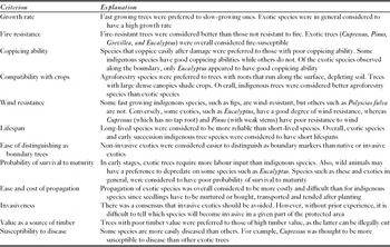
Edge-interior trends of resource extraction and density of exotic species were calculated as averages of counts per plot and fire incidences as an average of presence/absence records. To determine suitability of individual species as boundary markers, a list of potential indigenous (Myrica salicifolia, Agauria saliscifolia, Faurea saligna, Nuxia congesta, Syzigium sp., Polyscias fulva, Harungana madagascariensis, Markhamia lutea, Maesopsis sp., Carapa grandiflora, Podocarpus milanjianus) and exotic (Cupressus lusitanica, Pinus sp., Grevillea robusta, Eucalyptus sp.) tree species was drawn up. Both exotic and indigenous trees were originally used to mark the boundary. Less suitable trees were eliminated by a set of criteria, based on analysis of their advantages and disadvantages (Table 1).
Evaluation criteria of species recommended for boundary marking in Bwindi Impenetrable National Park. In general, exotics were considered less suitable as boundary markers than indigenous species.

RESULTS
The boundary of BINP was 156 km long, demarcated by boundary markers, 34 km of rivers and streams and 12 km of roads. Edge-interior transects were over 100 km. Threats observed in and around the edge of BINP are considered separately.
Extractive use
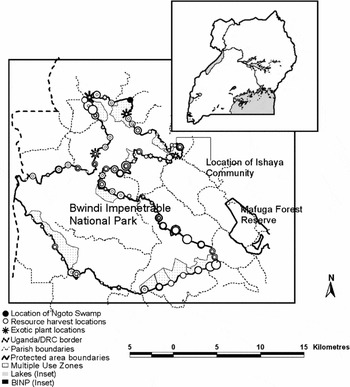
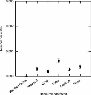
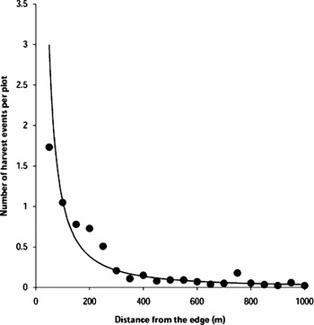
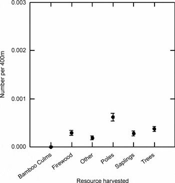
We observed signs of cutting of trees, poles, saplings/shrubs, firewood (dry wood) and bamboo culms. Other signs of harvesting were snares and traps, honey collecting, digging of root tubers and the cutting of stems for weaving materials. The signs were spatially clumped (Fig. 1). Pole harvesting signs were most commonly encountered, followed by harvest of trees (stump size usually < 20 cm diameter), saplings or shrubs (stump diameter < 5 cm) and firewood (harvested when dry). Signs of harvesting bamboo and other products were rare (Fig. 2), signs being commonest within 350 m of the Park boundary (Fig. 3). Firewood harvest sign was the commonest form of harvesting within 10 m of the Park boundary line. Evidence of harvesting trees for timber was minimal; we observed only three incidences of trees cut for timber.
Map of Uganda (inset) showing the location of Bwindi Impenetrable National Park (BINP, dark blob along the south-western border) and map of BINP showing surrounding parishes, resource harvest points and distribution of exotic species as assessed from boundary walks. Symbol sizes for resource harvest and exotic species are proportional to intensity of harvest.

Mean number of harvests encountered per 400 m of the Park boundary up to 60m from the boundary, as assessed from boundary walks (±1 SE).
Mean number of plant harvest events per plot with distance from the forest edge in BINP, the trend of harvesting along an edge-interior gradient being best approximated by a power function.

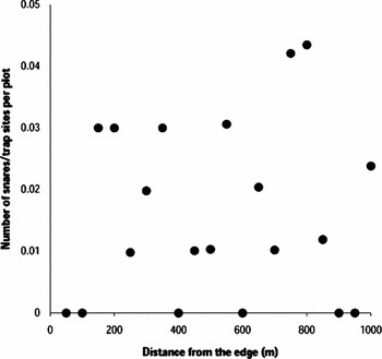
There was no evidence of recent mining inside the Park; only two freshly dug mining pits were observed at a single site just outside of the Park boundary. Evidence of hunting (numbers of snares and trap sites encountered) was uncommon. Snares were not seen within 150 m of the park edge, but their encounter rate tended to increase towards the interior (Fig. 4). Most snares were found near the bamboo zone.
Plot of mean number of items of hunting evidence against distance from the edge of BINP.

Agricultural encroachment, livestock grazing and fire damage
Agricultural encroachment was minimal and typically involved slight boundary shifts. However, one clearing measuring 920 m2 was encountered 550 m inside the Park. Seven small patches were observed at various sites near the edge, ranging from 33 m2 to 3037 m2 in area. Altogether, ongoing encroachment covered a total area just over 0.5 ha in the 1-km wide peripheral region.
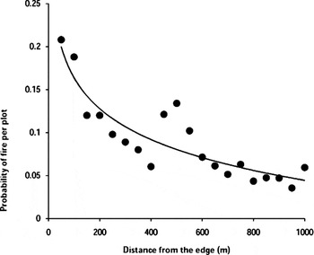
Livestock grazing inside the Park was minimal and usually occurred within 20 m of the boundary. There was no evidence of intensive vegetation cropping or heavy trampling, suggesting that the areas visited by livestock were not overgrazed. On average, livestock or livestock sign (tracks or dung) on the boundary line were encountered 0.04 times per 50 m length of the boundary line. Evidence of fire burns was commonest near the edge, decreasing rapidly within the first 150 m and thereafter gradually towards the forest interior (Fig. 5).
Plot of probability of evidence of previous burns against distance from the edge of BINP, the edge-interior trend being best approximated by a logarithmic function.

Wild animals coming out of the Park
There was evidence that several large mammal species crossed the Park boundary into adjacent land. Baboon (Papio anubis) signs were the commonest, encountered at an average rate of 1.39 per km, followed by bushpig (Potamochoerus lavartus) (0.20 km−1), gorilla (Gorilla beringei beringei) (0.15 km−1), sightings of arboreal monkeys (blue monkey Cercopithecus mitis, l'hoest's monkey Cercopithecus l'hoesti, redtails Cercopithecus ascanius and black-and-white colobus Colobus guereza) (0.14 km−1), chimpanzee (Pan troglodytes) (0.10 km−1) and duiker (black-fronted duiker Cephalophus nigrifrons and yellow-backed duiker Cephalophus sylvicultor) (0.09 km−1). Signs of forest carnivores (usually serval cats Felis serval, side-stripped jackals Canis adustus, and golden cats Profelis aurata and African civets Viverra civetta) and elephants (Loxodonta africana) were rare (0.09 km−1). Baboon and chimpanzee signs were twice as high in the northern sector (0.10 km−1) as compared to southern sector (0.05 km−1), while monkey sightings and carnivore and duiker signs were equally common in both sectors (northern sector average = 0.15 km−1, southern sector average = 0.18 km−1). Bushpig signs were three and a half times higher in the southern sector (northern sector 0.06 km−1, southern sector 0.23 km−1); elephant and gorilla signs were encountered only in the southern sector.
Occurrence of exotic plants
Nineteen exotic plant species were found inside the Park, but only a few of these were common and had the ability to propagate without human assistance. These species in decreasing order of stem density/clumps were Lantana camara, Cupressus lusitanica, Camellia sinensis, Datura suaveolens, Eucalyptus grandis, Acacia mearnsii, Medicago sativa, Sesbania sesban, Passiflora incarmata, Coffea arabica, Pinus sp., Persea americana, Grevillea robusta, Carica papaya, Xanthosoma sagittifolium and Helianthus maximiliani. The bracken fern (Pteridium aquilinum) was widespread, colonizing large gaps throughout the Park. Only eight of these species (47%) were found in edge-interior transects with two others, namely Cannabis sativa (marijuana) and Cyphomandra betacea (tree tomato) which had been planted in a clearing inside the Park.
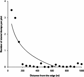
For eight species, less than 20 individuals each were found. For Medicago sativa and Datura suaveolens, the stems appeared to have been planted by people. Eucalyptus grandis and Acacia mearnsii appeared to self-propagate, as seen by small plants at various stages of growth nearby. Young Eucalyptus grandis grew only underneath parent plants in a small (<1 ha) experimental plantation more than 15 years old, and Acacia mearnsii plants were found only within 5 m of the edge. The only species that appeared to spread on their own deeper (>10 m) into the Park boundary were Lantana camara and Camellia sinensis in the northern sector, Cupressus lusitanica in the south-east, and Passiflora incarmata and Pteridium aquilinum throughout the Park. Exotic plants were usually found within 200–250 m from the edge (Fig. 6).
Plot of mean number of stems/clumps of exotic plants against distance from the edge of BINP, the edge-interior trend indicated by a logarithmic function.

Illegal activity inside multiple use zones
Signs of illegal resource extraction were observed both in multiple use and non-multiple use zones (Fig. 1). Illegal activity in these zones included cutting of small trees and branches within 5 m of beehives, planting of exotic Datura suaveolens to attract bees, and in one case, association of snares with beehives. At least 10 snares were found within a 30 m radius of a bee-keeping site. We also noted a case where resource users were apparently not clear about the limits of the multiple use zone and harvested in an ungazetted area.
Boundary marking and maintenance
Of the boundary section unmarked by roads, rivers and streams, 16.7 km were marked by soil mounds, and the rest (93.2 km) by tree markers. The trees planted were Cupressus lusitanica, Pinus sp., Eucalyptus sp., Markhamia lutea and Ficus spp. Cupressus and Pinus were dying out, and three Cupressus trees were observed to have been cut for timber. More than 10 Markhamia trees were cut, but the reason was not apparent. Overall, live boundary trees averaged 0.5 trees km−1. Maintained sections of the boundary line, including cleared sections and stretches of roads, streams and rivers, altogether accounted for approximated 59% of the total boundary length.
Based on observations along the boundary using criteria such as ease of propagation, suitability as a source of timber, resistance to fire, disease and wind, impact on crops and other criteria (Table 1), indigenous species had better potential as boundary markers than exotic species. Of the indigenous species considered, Ficus species was considered the most suitable for BINP, followed by Markhamia lutea and Carapa grandiflora.
Degradation of natural habitats adjacent the Park
There was intensive logging of the few remaining forest fragments adjacent to the Park. Interviews with Park rangers and key informants in the local community showed that Ngoto swamp was of tourist interest, and that tour companies sometimes took tourists to watch endemic birds. The swamp is important for conservation of the near threatened papyrus gonolek (Laniarius mufumbiri) and white-winged warbler (Xenoligea montana), which are both restricted to the papyrus reedbed, and Caruther's cisticola (Cisticola carruthersi) which prefers marshland. Grauer's rush warbler (Bradypterus graueri), a highly threatened endemic of the Albertine Rift, was thought to occur in this swamp, but its presence has not been confirmed. The swamp also contains the tree Voacanga thouarsii, and is the only place in the Park where the species was found. The swamp is also important because of it function in water flow, as the Kiizi river drains the swamp and flows back into the Park.
According to the rangers and local community members interviewed, the main threat to the swamp was fire, which occasionally burnt the entire swamp, but not the small portion (< 10% of the swamp) occurring within the Park. Fires were set by people who harvested papyrus to generate high quality stems for weaving. Respondents also said that fires were sometimes put out by fisherfolk who believed that burning reduced fish catches; however, the fishers were frequently unable to extinguish the fire.
People-park conflict and wildlife impact on the Ishaya community
We noted stunting of crops in fields shaded by trees near the Park edge, or in the vicinity of Cupressus or pines planted as boundary markers and this was confirmed by the local community. We also observed Park trees that had fallen outside the Park, and raiding of crops by wildlife, especially baboons. The local community complained of baboons and other wild animals stealing their chickens and killing young goats.
Interviews with the catechist and two elders of the Ishaya community (nine households) revealed that they had lived in the area for over 40 years, but perceived themselves as increasingly isolated because of migration of communities in four parishes (Masya, Kifunjo, Muramba and Kinaba) away from the Park edge as a result of crop raiding by wild animals, usually baboons. The community was isolated from neighbouring homes by a 1.5 km walk and a 350 m ridge. Nearby markets, schools, and health centres were located much further away. According to informants, the community could not grow food crops in their gardens and had to maintain 12 hour watches over their livestock. Their isolation, they said, was a result of there being no alternative place for them to settle and they were eager to see the Park purchase their land so that they could buy land elsewhere.
DISCUSSION
Prior to BINP attaining national park status in 1991, there was widespread timber harvesting and other forms of resource exploitation, including hunting and gold mining, and gathering of firewood, poles and stakes (T. Butynski, unpublished report 1984; Howard Reference Howard1991). These activities were widespread, but were most intensive within 1 km of the Park edge (T. Butynski, unpublished report 1984), while the outer 61% of the Park was heavily logged (Howard Reference Howard1991). We found that most resource harvesting occurred within 300–350 m of the Park edge and was patchily distributed. Evidence of recent gold mining was not found in the Park, timber harvesting was very rare and fires were less common than in 2001 (A. Kasangaki, D. Babaasa, R. Bitariho, & G. Mugiri, unpublished report 2001). These findings suggest that Park legislation and complementary law enforcement efforts and community outreach and support programmes have overall achieved greater Park security. However, the loss and degradation of habitats around the Park, and other studies (see DeFries et al. Reference DeFries, Hansen, Townshend, Janetos and Loveland2000; Bounoua et al. Reference Bounoua, DeFries, Collatz, Sellers and Khan2002) indicate that a well-protected edge alone might not be enough for long-term conservation and there is need to allow for habitat connectivity.
At site level, occurrence and extent of resource exploitation are likely influenced by such factors as degree of law enforcement (including both occurrence of ranger outposts and law enforcement effort), ease of Park access as determined by proximity of settlements or occurrence of barriers such as a large river along the boundary, proximity to habitations of people willing to take risk, availability of alternatives such as wood for building and fuelwood, and options for non-Park related income. We recommend that future studies examine relationships between concentrations of illegal activity and these potential predictor variables.
We now also have greater understanding of threats to BINP and forests in general, especially with respect to exotics, boundary maintenance and hotspots of human-wildlife conflict. One threat deserving greater attention is the occurrence and spread of exotic plants. Impacts of invasive exotic species on native species, communities and ecosystems are widely recognized (Elton Reference Elton1958; Simberloff Reference Simberloff1996; Reaser et al. Reference Reaser, Meyerson, Cronk, De Poorter, Eldrege, Green, Kairo, Latasi, Mack, Mauremootoo, O'Dowd, Orapa, Sastroutomo, Saunders, Shine, Thrainsson and Vaiutu2007), and exotic species have received widespread recognition as one of the world's most serious causes of species decline and habitat degradation (Vitousek et al. Reference Vitousek, D'Antonio, Loope, Rejmanek and Westbrooks1997; Wilcove et al. Reference Wilcove, Rothstein, Dubow, Phillips and Losos1998; D'Antonio & Meyerson Reference D'Antonio and Meyerson2002). Management of non-indigenous species is therefore a crucial aspect of maintaining native biodiversity and normal ecosystem functions (Byers et al. Reference Byers, Reichard, Randall, Parker, Smith, Lonsdale, Atkinson, Seastedt, Williamson, Chornesky and Hayes2002) and many protected area management plans have included eradication densities as core activities (D'Antonio & Meyerson Reference D'Antonio and Meyerson2002). Prior to this study, BINP management was aware of occurrence of Eucalyptus sp. in two small (<1 ha) plantations set up by the Forest Department to test its suitability for planting by the local community. However, other exotic species and their extent in the Park were largely unknown. This study has shown that several species of exotic plants occur, but they are at present primarily at the periphery of the Park. Five species (Lantana camara, Camellia sinensis, Cupressus lusitanica, Passiflora incarmata and Pteridium aquilinum) may be spreading without direct aid by humans. Of these, only L. camara, C. lusitanica and P. acquilinum may be presently of conservation concern. L. camara has likely spread into the forest from fields north of the Park (R. Barigyira, personal observation 2001) and C. lusitanica from trees planted to mark the Park boundary at the south-eastern edge. The point of entry of P. acquilinum is unclear.
The second issue concerns loss of boundary marking, insufficient maintenance of the boundary line and choice of trees to plant as boundary markers. Related to this is the management of trees at the Park edge. Boundary marking and maintenance make agricultural encroachment difficult, and reduce the possibility of fires spreading from neighbouring fields into the Park (Cochrane Reference Cochrane2003). Live tree markers can also help to regenerate gaps opening up on the edge by serving as nuclei (Holz & Placci, Reference Holz, Placci, Mansourian, Vallauri and Dudley2005). Sparseness of live tree markers lies in the fact that the exotic trees used are dying, perhaps of old age, but also from fires, which typically start from the edge. The only live tree markers surviving on the boundary were figs and other indigenous trees. Concerns related to perceived reduction of soil fertility by exotic trees planted as boundary markers or shading of crops and Park trees falling on crop gardens were uncommon, but still an issue to the individuals affected. This is because land is scarce; the landscape is heavily populated and every small piece of land is highly valued by the local community. Using fig trees and other indigenous trees as boundary markers may help resolve some of these problems. Fig trees are easy to propagate, they have no timber value, are wind resistant, are long lived, can grow in open situations, are fire-resistant and are considered crop-friendly, among other suitable characteristics. Future research to deepen insight into the relationship between boundary management practices and attitudes of local communities towards the Park could take the form of household attitude surveys (Heinen Reference Heinen1993).
The third issue concerns assessment and monitoring of potential hotspots of human-wildlife conflict and what to do when neighbouring communities are severely impacted by such conflict. With respect to human-wildlife conflict, some studies have quantified the extent and spatial patterns of crop damage by specific wildlife species through monitoring crop fields (see Naughton-Treves Reference Naughton-Treves1997; Naughton-Treves et al. Reference Naughton-Treves, Treves, Chapman and Wrangham1998; DeVault et al. Reference DeVault, Beasly, Humberg, MacGowan, Retamosa and Rhodes2007). Another approach is to identify locations where the human-wildlife conflict problems are serious along the edge. Assessments along the boundary line should be used to validate reports from communities. Solutions to crop raiding should in some cases directly address livelihood issues of communities that are severely affected. For example, they could be financed to relocate if they strongly so desired, as was the case for the Ishaya community.
An edge-based approach to threat assessment can be useful in elucidating types and extents of threats to protected areas and in proposing solutions. W. Olupot (unpublished report 2004) gave a number of recommendations as to how threats along the edge could be resolved. Since then, there are indications that actions have been taken in response to Olupot's (unpublished report 2004) recommendations. For example, exotic species management is now reflected in Uganda Wildlife Authority's management plans (see Uganda Wildlife Authority, unpublished management plan for Semliki National Park 2005) and the International Gorilla Conservation Program (IGCP) removed exotic plants from the 4.2 km2 of land adjacent to the Park bought from the local community to facilitate gorilla tourism. Also, IGCP and the World Conservation Union (IUCN) Uganda Programme have developed tourism management plans and management strategies, respectively, for the Ngoto swamp (Stephen Asuma, personal communication 2008).
CONCLUSIONS
An edge-based approach has permitted a better understanding of the range of anthropogenic threats in BINP and threats in BINP have been drastically reduced since it was upgraded to national park status in 1991. This approach should be generally applicable to forested tropical parks, and in this case has revealed several previously unknown threats, including the occurrence of exotic plants, loss of boundary markers, boundary maintenance, isolation of a community as a result of crop raiding, and management of what appears to be a sensitive habitat along the Park boundary. The edge-based approach has many advantages to investigating threats to national parks, including spreading sampling around the park, not biasing sampling to easily assessable boundary areas, identifying hotspots of anthropogenic threats and human-wildlife conflict, and quantifying the distance that various threats penetrate into the park, thus estimating the proportion of the park that is primarily untouched.
ACKNOWLEDGEMENTS
We thank all field assistants who made this study possible, in particular Godfrey Mayooba, Chrispine Safari, Benon Twehikire, Philemon Tumwesigye, Narsi Owesigire and Damazo Zoreka. We are grateful to Sam Ayebare of WCS Uganda office for helping with GIS work. We also thank the Uganda National Council of Research and Technology and the Uganda Wildlife Authority for permission to conduct the research. The study was funded by the Wildlife Conservation Society.