Introduction
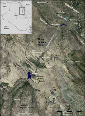
The river that is known in Kurdish as the Sirwan and in Arabic as the Diyala, which flows from its headwaters in the Zagros Mountains of western Iran to its ultimate confluence with the Tigris River just south of Baghdad, holds a special place in the archaeology of the ancient Near East (Fig. 1). It was in the lower plains of the Diyala where in the 1920s–1930s the University of Chicago's Oriental Institute undertook major excavations at the sites of Tell Asmar, Khafaje, Ishchali and elsewhere, transforming our knowledge of Bronze Age Mesopotamian civilisation and recovering some of the hallmark works of art and architecture known from this period (Frankfort et al. Reference Frankfort, Jacobsen and Preusser1932; Reference Frankfort, Lloyd and Jacobsen1940; Delougaz Reference Delougaz1940; Delougaz and Lloyd Reference Delougaz and Lloyd1942; Delougaz et al. Reference Delougaz, Hill and Lloyd1967). The vast plains surrounding these sites also served as the proving grounds for Robert McC. Adams’ first major survey project, published as Land Behind Baghdad (Reference Adams1965). His work revolutionised our understanding of the emergence and development of complex societies in Mesopotamia and pioneered new regional-scale approaches to the archaeology of landscapes.
Map of the Sirwan/Diyala region with key sites mentioned in the text (base map © MDA Information Systems 2010, USGS and NASA)

While Iraqi Department of Antiquities-led excavations continued in subsequent decades, particularly at sites impacted by the growth of Baghdad such as Tell Harmal (Baqir Reference Baqir1946, Reference Baqir1948; Hussein Reference Hussein2001) and Tell edh-Dhibaʾi (Mustafa Reference Mustafa1949; Al-Gailani Reference Al-Gailani1965; Hamoodi Reference Hamoodi1990), most of the Diyala region, particularly in its upper reaches, has seen little archaeological research. A few of the most prominent sites in the Upper Diyala corridor were mapped in the 1960s for inclusion in the national Iraqi Archaeological Atlas (Iraqi Directorate General of Antiquities 1970) and excavations were later undertaken by the Iraqi Department of Antiquities at the multi-period mound of Qala Shirwana and the Halaf/Ubaid site of Tepe Rahim. The most extensive work took place in the 1970s when, in advance of the construction of a major dam just north of the Jebel Hamrin, a survey was executed in the impacted area and salvage excavations were undertaken at numerous sites (e.g. Roaf Reference Roaf and Curtis1982; Postgate and Roaf Reference Postgate and Roaf1982; Killick Reference Killick1988; Yaseen Reference Yaseen2005). The region to the north of the Hamrin basin and below the Sharezor Plain,Footnote 2 remains for the most part an archaeological terra incognita.
The Sirwan Regional Project is an archaeological expedition undertaken jointly by the authors, in cooperation with the Garmian Department of Antiquities, headquartered in Kalar, Kurdish Regional Government. The project, which was initiated in 2013, undertakes extensive archaeological survey, paleo-environmental investigations, and targeted excavations throughout our study area, encompassing all periods of human occupation, from early prehistory through early modern times. The Upper Diyala/Sirwan constitutes a key transitional zone between the lowland Mesopotamian plains and Zagros highlands, serving as one of the primary transport and communication routes connecting these historically important regions. As such, archaeological investigations have great promise to shed light on issues ranging from the emergence of sedentary agriculture, the development of the world's first complex societies, and the cultural interactions that took place between imperial centres of power in lowland Mesopotamia and Iran and the highland communities of the Zagros.
This paper introduces the physical landscape of the study area, presents an overview of our methods for discovery and documentation of archaeological remains, and a brief summary of our initial findings from the 2013–2015 seasons highlighting a few key sites that have been documented to date. While much of the region remains to be investigated and many of our interpretations are necessarily provisional, our results to date nonetheless clearly demonstrate the enormous potential of the region for continued research and highlight some of the major issues we will be investigating next.
Geographic Setting
The Sirwan Regional Project's study area comprises approximately 4000 square kilometres along the main branch of the Diyala River and into the surrounding highlands, extending from the town of Darbandikhan in the north to the southern edge of the Kurdistan Region at the Jebel Nasaz range (Fig. 1). The Qara Dagh mountains at the northern edge of the area separate it from the Kurdish plateau, home to the Sharezor Plain and the city of Suleymaniyah, while the steep Zagros front ranges of the Kuh-i Bamu and Kuh-i Bishkhan along the modern Iranian border form the eastern edge of the survey.
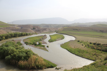
The study area encompasses a wide variety of environmental zones, with major differences in water and resource availability, agricultural potential, and ease of communication and transport. The geography of the region is therefore key to understanding settlement history, patterns of land use, as well as the variable preservation of archaeological sites. The main branch of the Diyala between the modern towns of Darbandikhan and Kalar forms a deeply incised channel, flowing more than 100 metres below the relict gravel terraces above (Fig. 2). Within the narrow modern floodplain, the river forms a high-energy braided channel. During heavy rains in winter months as well as during spring snow melt in the Zagros, the river floods this narrow plain, making it poorly suited to permanent settlement as well as most types of agriculture. Navigation on this part of the river is possible only in small boats, but the river nonetheless offers abundant resources in terms of fish, water, and animal pasture during the arid summer months.
Photograph of incised Diyala/Sirwan River Valley

The western terrace of the river is the most arid part of our study area, with mean annual rainfall of less than 250 millimetres and few permanent springs. Today, much of this region is farmed with an annual cereal crop using mechanised pumping of Diyala water, but in antiquity cultivation would have been unreliable, with a rainfed crop only possible in unusually wet years. Numerous large seasonal wadis flow into the Diyala along the western side of the river, and at high elevations to the west there are a few perennial springs and also modern villages, but for the most part this region appears to have been home to relatively little ancient settlement.
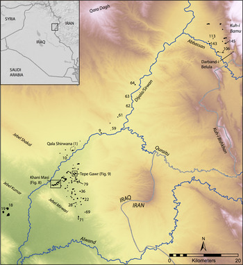
The eastern side of the upper river valley is quite different from the west, owing to abundant springs and groundwater supplied by high rainfall and seasonal snow melt in the Iranian Zagros. Three major tributaries of the Diyala, the Abbassan, Quraitu, and Alwand Rivers (Fig. 3), flow throughout the year and offer the possibility of reliable irrigated cultivation on the high terraces to the east of the Diyala. These areas also receive considerably more rainfall than elsewhere in the region due to the orographic effect of the Zagros, enabling more reliable dry farming of cereals. Unsurprisingly, these agriculturally rich tributary valleys appear to have had significantly more ancient settlement than the eastern side of the Diyala. Above the well-watered plains along the foothills of the eastern terrace loom the high, rocky peaks of the Zagros, occasionally bisected by deep drainages. Within this upland zone traditional forms of agrarian settlement are scarce outside of occasional small valleys where springs are present, but the region is rich in cave sites, religious shrines, and fortifications of various periods.
Map illustrating location of archaeological sites documented by the Sirwan Regional Project (2013–2015)

The tributary river valleys of the Abbassan, Quraitu, and Alwand also constitute a key communication and transport corridor connecting the Diyala and thereby lowland Mesopotamia with the Iranian Plateau. Rawlinson (Reference Rawlinson1839) reports on the relative ease of movement through these upland river valleys, which at the time collectively constituted the Ottoman Pashalik of Zuhab/Zohab (Kashani-Sabet Reference Kashani-Sabet2000).
South of the modern town of Kalar, the landscape changes dramatically as the high, arid terraces of the northern Diyala Valley give way to several low-lying basins constrained between a series of hill ranges (Figs. 1, 3). Kalar is also situated at the northernmost year-round ford across the river. Because the main branch of the Diyala in this area remains incised, flooding and sedimentation on the flanking basins are rare, while traditional irrigation from the Diyala is challenging. However, these basins are amply watered by a large number of artesian springs, supplied by groundwater in the Zagros. These springs flow together to form streams, and produce marshlands in some parts of the basins. In the Khani Masi plain to the east of Kalar where much of our work to date has been focused, these reed-covered marshlands at the southeastern part of the plain are known as “Suz Bulak”, an archaising Kurdish name that is roughly translated as “Green Springs”.
Like the upper terraces, the flanking basins south of Kalar receive too little rainfall to support dry farming, but the abundant perennial water supply, the rich soils, and the relative ease with which traditional forms of irrigation agriculture can be undertaken make these basins among the most agriculturally productive in the entire region. At the same time, the lack of significant sedimentation from the Diyala during the Holocene results in much better archaeological preservation than seen to the south of the Jebel Hamrin, where heavy sedimentation along the anastomosing channels in the broad alluvial fan has buried much of the landscape below many metres of sediment (Adams Reference Adams1965). It is within these basins of the Middle Diyala that we find the richest archaeological record in the entire region, with a high density of sites from all periods of human settlement dating back to the Pre-Pottery Neolithic, as well as all of the largest settlements of later periods, from the Bronze Age to the present day (Fig. 3).
Methodology
The Sirwan Regional Project's survey area, at around 4000 square kilometres, is quite large by modern survey standards and encompasses a wide variety of challenging archaeological landscapes, including rugged highlands, arid plateaus, and marshy irrigated fields. Moreover, as discussed above, at the start of the survey project very little was known regarding the archaeology of the region. The national Iraqi Archaeological Atlas, for example, recorded numerous historic sites in the region near Darbandikhan, but only six of the tallest mounds in the Khani Masi plain, without dating information, and recorded virtually nothing in the other plains to the south. Moreover, because the area is witnessing rapid industrial, urban, and agricultural development, many archaeological sites and features are being destroyed at an alarming rate. We have thus developed a survey strategy that seeks to maximise site discovery.
In our initial seasons of fieldwork, we relied primarily on analysis of satellite imagery, including both declassified 1960s-era CORONA (Casana et al. Reference Casana, Cothren and Kalayci2012) and modern high-resolution GeoEye and WorldView imagery, for the identification of sites. Prior to our first field season, we mapped more than 600 probable archaeological sites, primarily concentrated in the lower plains to the south and east of Kalar as well as in the plains of the upper eastern terrace. Much of our fieldwork to date has been devoted to ground-truthing features identified on satellite imagery and historic maps, sites recorded on the Iraqi Archaeological Atlas, as well as opportunistic spot finds and informant-led discoveries made in the course of survey. For each site we identify, we create a map, record detailed physiographic features, and conduct collections of surface artefacts, demarcating them into major topographic features of sites when possible (e.g. high mound, lower slope, etc.).
In 2014–2015, we instituted a complementary strategy to both acquire more information from key sites and begin to improve our knowledge of particular periods. Alongside more traditional regional survey, we now select three to four key sites per season, particularly those dating to lesser known periods and possessing relatively shorter occupational histories. On these sites we conduct aerial photogrammetric mapping (using either a kite or a small quadcopter), magnetic gradiometry or other geophysical survey and, guided by the results, we then undertake targeted excavation of features at one or two sites. Test excavations, typically in a 1 × 4 metre sounding, provide more contextual information than surface finds as well as a more secure sample of a particular ceramic assemblage, paleobotanical, faunal, and other data, alongside radiocarbon and OSL samples that offer absolute dates for particular phases of settlement. This adaptable and flexible strategy, which can be thought of as a horizontal approach to archaeological stratigraphy, will ultimately serve as the basis for a greatly refined local material culture chronology not normally achieved in more traditional surveys in the wider Middle East.
Settlement history
Of the approximately 600 probable sites identified on satellite imagery, our project has visited and recorded 148 sites to date, as well as numerous ancient irrigation works and other water management features (Fig. 3). Sites range in date from the Pre-Pottery Neolithic through to the early modern period, with most major phases represented. We have focused the majority of our work in two parts of our study area, the Khani Masi Plain just east of Kalar, and the Abbassan Valley at the northern end of our survey area along the Zagros flanks. We have also conducted brief exploratory surveys in other parts of the region, including along the high central terraces and in the southwestern flanking basins of the Diyala Valley. Assessing the complete range of occupation at the sites even within the relatively well-sampled Khani Masi Plain and Abbassan Valley is an ongoing project due primarily to the relatively poorly known local ceramic sequence. In some periods, the ceramics of the Upper Diyala are sufficiently closely related to better-known material culture sequences from lower Mesopotamia, the Jazireh, or the Iranian Plateau to enable confident identification, but in other periods such linkages are tenuous at best. While we continue to refine our ability to identify particular phases with confidence, we can nonetheless begin to sketch out some broad patterns in settlement over time. Below we present results from several key type sites that illustrate the nature of occupation in various periods as well as the type of material culture encountered in the region.
Early prehistoric sites
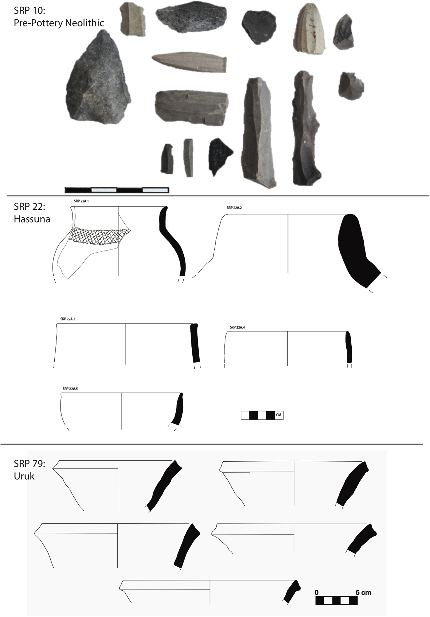
Particularly within the flanking basins to the south of modern Kalar, we have found a rather large number of early prehistoric occupations, a fact which is made more significant given the near total absence of pre-Uruk period settlement in the lower Diyala plains (Adams Reference Adams1965). The oldest settlement discovered thus far is a Pre-Pottery Neolithic site (SRP 10), with lithic material that has many linkages to finds from Jarmo not far to the west (Braidwood and Howe Reference Braidwood and Howe1982). Lithics recovered from the site include a large number of micro-blade tools, prismatic cores, and occasional obsidian blades (Fig. 4). The site forms a mound measuring eight metres in height and is located on the western side of the Diyala, just south of modern Kalar. Today SRP 10 is surrounded by intensive date palm cultivation and is adjacent to a small spring. Like most prominent mounded sites in the region, the top of the mound was badly damaged by construction of a military garrison during the 1980s, cutting primarily into the Sasanian levels at the top of the site.
Prehistoric finds, including (top) Pre-Pottery Neolithic materials from SRP 10, (middle) Hassuna ceramics from SRP 22, and (bottom) Uruk-period bevelled-rim bowls from SRP 79 (drawings: Francesca Chelazzi, Evrim Nazli Şerifoğlu, Lorraine McEwan)
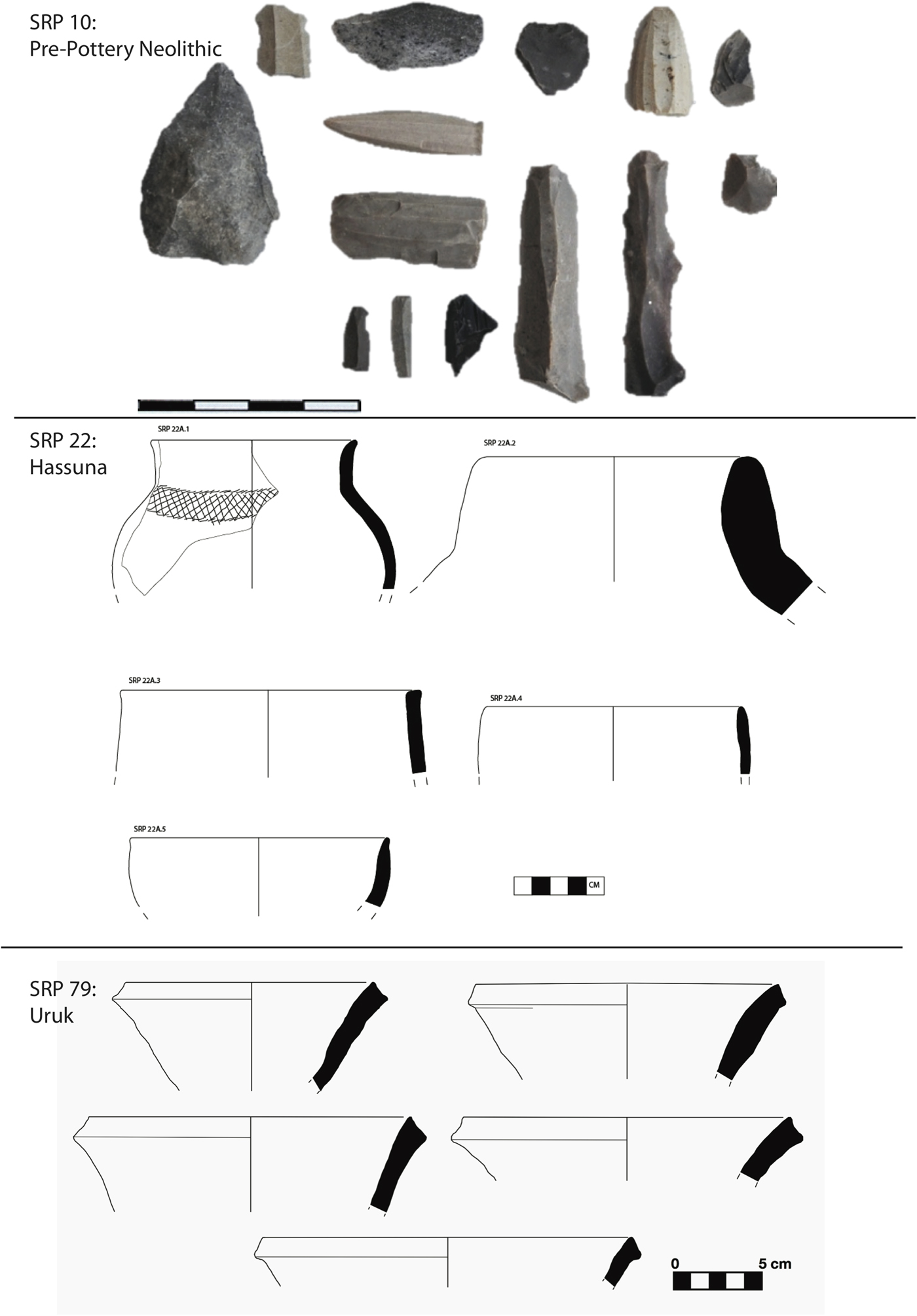
Numerous sites recorded were occupied in the Pottery Neolithic, and these generally display close affinities to Hassuna sites known from northern Mesopotamia. Some sites, such as Fallah (SRP 22) contain the full range of standard Hassuna pottery, leaving little doubt regarding their date (Fig. 4). However, numerous other sites, such as Tepe Sirwan (SRP 36), located just 1.5 kilometres to the north, seem to date to a chronologically distinct but Hassuna-related phase. Ceramic collections from Tepe Sirwan and other sites like it are overwhelmingly dominated by coarse, handmade, chaff-tempered, chaff-faced wares, with incised pottery of a better known Hassuna type comprising less than five percent of the assemblage. However, the assemblage also includes so-called “husking trays” as well as numerous bowls and necked jars typical of the Hassuna period. The absolute date of this assemblage remains uncertain, but has its closest parallels with the Lower Phase at the nearby site of Matarrah (Braidwood et al. Reference Braidwood, Braidwood, Smith and Leslie1952) and possibly the archaic Hassuna found in the earliest level of Tell Hassuna (Lloyd et al. Reference Lloyd, Safar and Braidwood1945). Given these parallels, the assemblage likely falls sometime during the late seventh or early sixth millennium b.c. The absence of Samarran pottery at any site yet discovered is notable, given the relatively close proximity of our survey area to Chogha Mami (Oates Reference Oates1969), suggesting a proximate boundary between the two ceramic cultures around the Jebel Hamrin.
Several sites have produced high-quality Halaf period wares. Halaf sites are particularly numerous in the Khani Masi plain, where a string of Halaf sites are present along the relict levees on the eastern side of the Diyala including SRP 43, 93, 118 and 101. Several sites in the southern Khani Masi plain, including SRP 28 and SRP 69, show a continuation of occupation into the Ubaid period, with strong affinities to southern Mesopotamian Ubaid materials. The presence of both Halaf and Ubaid wares in the region is significant, as south of the Jebel Hamrin Halaf materials are generally absent (Campbell Reference Campbell1992), suggestive again of a proximal boundary between Halaf and early Ubaid cultures.
Uruk period (fourth millennium b.c.) sites appear rarely compared to earlier and later settlements, perhaps because they lie buried beneath later Bronze Age settlements. One site, Gakol Kale (SRP 79), produced a large collection of bevelled-rim bowls, in addition to earlier Ubaid wares, suggestive of continuous occupation from the Ubaid to Uruk periods (Fig. 4). However, the site is largely covered by an Ottoman fort and early modern occupational debris. Two other small sites, SRP 117 and 119, located a few hundred metres apart on a relict Diyala levee at the western edge of the Khani Masi plain, appear to be late fourth or early third millennium b.c. in date. SRP 117 produced a large surface collection including many bevelled-rim bowls and several spouted vessels typical of the Uruk/Jemdet Nasr periods. The presence of brown and plum-coloured painted pottery with geometric motifs of Jemdet Nasr style, as well as several squat neck stone vessels reminiscent of Early Dynastic types, points to an early third millennium date for the site, but the large majority of the assemblage is entirely local in character. The date of these sites and their relationship to nearby, likely contemporary settlements in the Hamrin basin that have very strong ties to classic southern Uruk/Jemdet Nasr cultures (Killick Reference Killick1988) will be one key issue for future investigation.
Bronze and Iron Ages
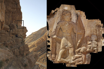
Our survey area is perhaps best known to Near Eastern archaeologists as home to the Bronze Age rock relief at Shaikhan (a.k.a. Darband-i-Belula; Fig. 5). Located in the steep Kuh-i Bamu range on the eastern side of the Abbassan Valley, it was originally documented by Rawlinson (Reference Rawlinson1839) in 1836 and has been the subject of much discussion (Börker-Klähn Reference Börker-Klähn1982: 139–40; Postgate and Roaf Reference Postgate and Roaf1997; Glatz Reference Glatz and Osborne2014). Most likely dating to the Old Babylonian period and depicting an unknown local ruler vanquishing another unknown local enemy, its presence indicates unambiguously the significance of the Upper Diyala during the Bronze Age but also underscores how little is known of the region or of its connections to communities in lowland Mesopotamia and Iran. Even within the immediate vicinity of the relief itself, no Bronze Age archaeological sites had even been recorded prior to our survey, with the relief standing as the only testament to the presence of people in the region.
Darband-i-Belula rock relief monument in the Abbassan Valley and 3D model (photo credit: Claudia Glatz; imagery processing: Elise Laugier)

The lack of previous archaeological research on the Bronze and Iron Ages in the Upper Diyala creates a challenge for dating occupations from these periods, as some phases, such as in the early to mid-third millennium b.c., show little resemblance to better known ceramic sequences from southern Mesopotamia or elsewhere. In the second millennium b.c., on the other hand, the ceramic assemblage at sites in the southern basins is fairly closely related to that from the Lower Diyala Plains, featuring a large number of characteristic goblets and employing the near homogeneous yellowish buff fabrics common throughout lower Mesopotamia between the Akkadian and Kassite periods. However, as noted by Adams (Reference Adams1965: 50–52), continuity in the Middle and Late Bronze Age south Mesopotamian ceramic tradition poses difficulties in distinguishing Old Babylonian from later Kassite-period occupations. By the first millennium b.c., we see very few of the typical Neo-Assyrian ceramics that are common in the Erbil Plain and elsewhere on the Upper Tigris and Zab rivers, again making it challenging to identify this period with confidence. Our work to build a local ceramic sequence is ongoing, and will ultimately be of great value in better dating our survey collections, as well as for exploring the changing nature of cultural connections between our study area, other parts of the western Zagros, northern and southern Mesopotamia, as well as Iran.
Despite the difficulties in dating much of the ceramic assemblage, we can nonetheless begin to make some generalisations regarding Bronze and Iron Age settlement (Glatz and Casana, Reference Glatz and Casana2016). Particularly in the northern part of our study area, in the Abbassan Valley, all occupations thus far discovered that date to the third, second and early first millennia b.c. are located at larger, multi-period mounds, as is characteristically the case in northern Mesopotamia and elsewhere (Wilkinson Reference Wilkinson2003; Casana Reference Casana2007). These mounded sites, including SRP 106, 113, and 143, measure up to thirty metres in height and tend to be situated in the most agriculturally productive regions, in areas surrounded by arable farmland and adjacent to perennial spring-fed streams (Fig. 3). In the southern part of our survey area, especially in the now well-documented Khani Masi plain, the nucleated, tell-based settlement system typical of dry-farmed areas of the northern Fertile Crescent begins to give way to a settlement pattern more characteristic of the southern Mesopotamian irrigated plains, in which sites are more numerous and occupations tend to be shorter lived. We still find significant Bronze and Iron Age settlement at prominent multi-period tell sites, but in the southern basins we have also recorded a significant number of low mounds dating to individual phases.
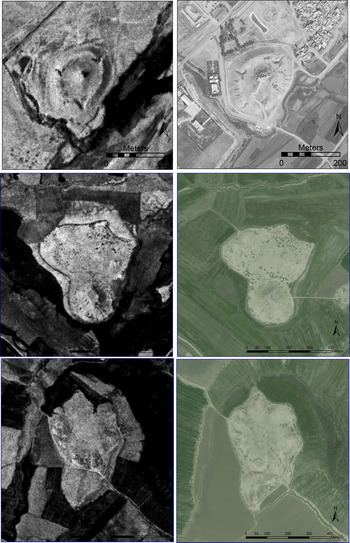
It is also within the southern basins on the banks of the main branch of the Diyala that we find the largest Bronze and Iron Age sites in the region. For example, on the outskirts of the modern town of Kalar lies the massive site of Qala Shirwana (SRP 1), one of the largest mounds in the KRG (Fig. 6). The site forms a mound measuring more than thirty metres in height, with an additional ten metres high citadel at the centre. In the 1800s, a chateau was built on top of the citadel, today housing a small culture and heritage museum, and the remainder of the site serves as a city park. The modern use of the mound makes conventional survey impractical, but significant excavation was undertaken at the site by an Iraqi team in the 1970s showing a long history of Bronze Age occupation. The site is thus a good candidate for the capital city of one of several historically known kingdoms thought to occupy the Upper Diyala, including Šimurrum (as suggested by Frayne Reference Frayne, Young, Chavalas and Averbeck1997: 104; but see Frayne Reference Frayne2008: 46; Altaweel et al. Reference Altaweel, Marsh, Mühl, Nieuwenhuyse, Radner, Rasheed and Saber2012: 9–11 for a different localisation), Lullubum, Namarum, and Nikum.
The major Bronze and Iron Age sites of (top) Qala Shirwana (SRP 1), (middle) Tepe Kalan (SRP 18), and (bottom) Binah Baj (SRP 19) as they appear on 1968 CORONA and 2011 GeoEye satellite imagery (2011 imagery © DigitalGlobe 2015)

Further to the south, other quite large Bronze and Iron Age sites have been recorded, including the notable site of Tepe Kalan (SRP 18; Fig. 6). It is among the largest sites in the region measuring around twenty hectares, with a prominent 4.5 hectare mounded feature possessing a rectangular top, rising twenty-five metres above the floodplain, suggestive of a temple mound that would be expected at many Mesopotamian cities. Collections from the site are primarily second millennium b.c., including a large assemblage of goblets and other materials quite reminiscent of Lower Diyala pottery of the Ur III through Kassite periods (Armstrong and Gasche Reference Armstrong and Gasche2014). The site also has medieval architectural remains across its surface, including a standing shrine, and is currently home to a Kurdish military base on top of the mound.
Just a few hundred metres from Tepe Kalan is another mound of similar size (c. fourteen hectares), Binah Baj (SRP 19), that also possesses a subtle three hectare upper citadel measuring around eight metres in height, suggestive of the presence of ancient elite architecture (Fig. 6). Collections at the site appear to include an earlier but poorly known third millennium b.c. assemblage, as well as a good range of identifiable Neo-Assyrian materials, including numerous carinated cups, a bronze fibula characteristic of the period, and an unusual object resembling a terra cotta stamp with a moulded lion on top. The close proximity of these two significant sites points to the importance of this area in general as a long-lived site for the location of administrative centres in the Bronze and Iron Ages. Numerous other very large sites have been identified through imagery analysis in this same region, but due to the security situation this far south, we elected for the time being to focus our efforts on regions further north.
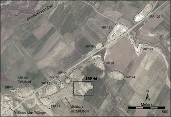
On the eastern side of the Diyala in the Khani Masi plain, we have recorded several dozen mounded Bronze and Iron Age sites, the tallest of which is Tell Majid or Khani Masi Tepe (SRP 39). This sizable mound has a long history of settlement, including a large Sasanian and early medieval occupation, but has been badly damaged by the construction of a military garrison on the top of the site. Tell Majid is the most prominent mound within a nearly continuous cluster of more than a dozen low mounds, all tightly clustered together along a 1.5 kilometre long area (Fig. 7). This concentration of sites, known as the Khani Masi site cluster, is situated on top of a relict Diyala levee, sufficiently above the active floodplain to the west as to avoid flooding. In addition, a series of perennial springs emerge from the plain to the east, coming together to form a sizable stream that flows into the Diyala adjacent to the site cluster, giving the area its name “Khani Masi” or literally, “fish springs.”
The Khani Masi site cluster as appearing on a 2011 GeoEye satellite image (© DigitalGlobe 2015). Mounds on this relict levee date from the Halaf to medieval periods, and include the major Late Bronze Age settlement at SRP 46

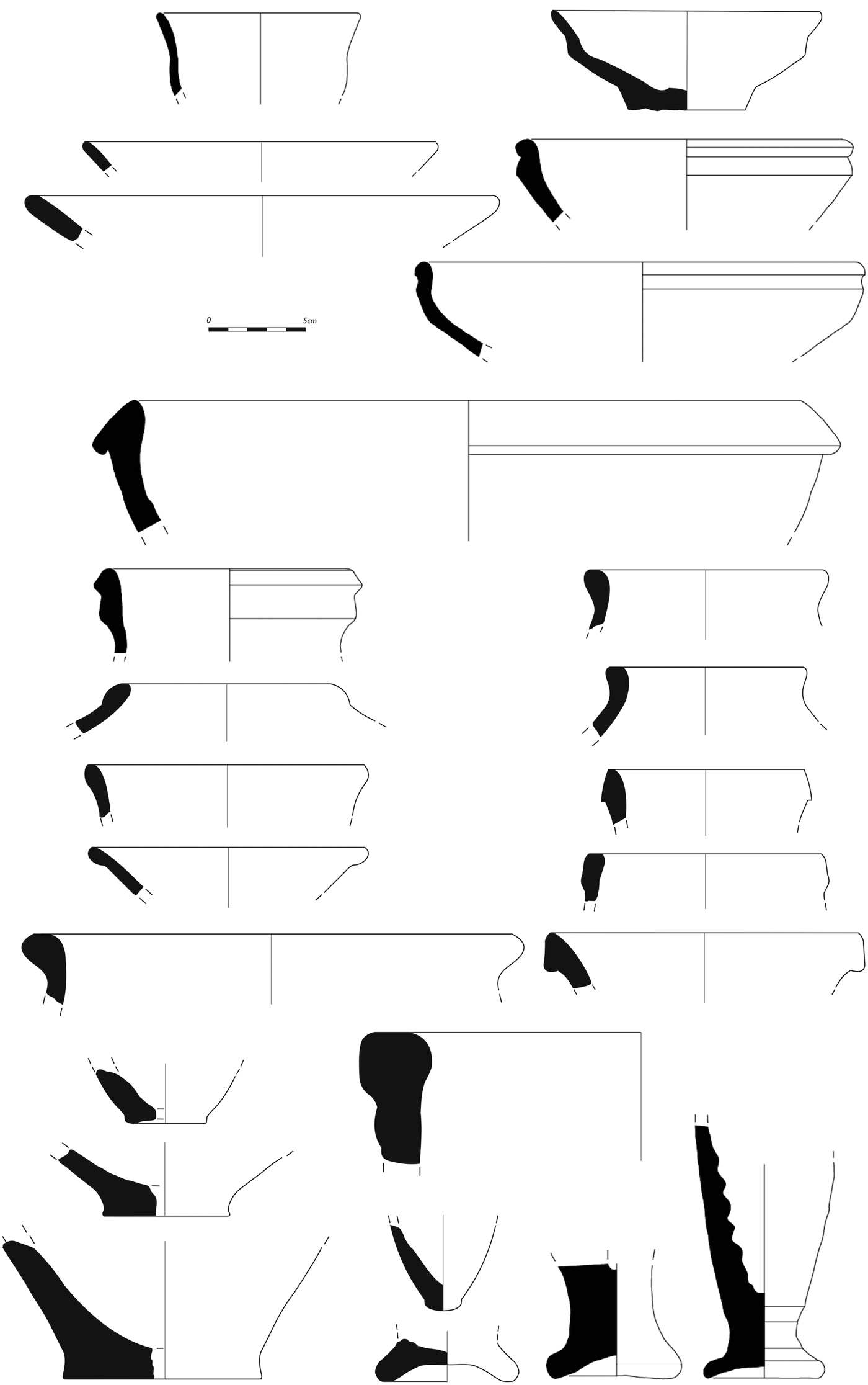
The individual mounds within the Khani Masi site cluster range in date from the Halaf to the Sasanian period, but one in particular deserves special mention. The site recorded as SRP 46 forms an extensive low mound, only a few metres above the plain but covering around eight hectares in area, and surface collection shows it to be almost exclusively mid- to late second millennium b.c. in date (Fig. 8). A geophysical survey conducted on the site in 2014 revealed extensive remains of burned, monumental buildings, while radiocarbon dates from a test excavation suggest a destruction in the thirteenth century b.c. (Glatz and Casana Reference Glatz and Casana2016). This very promising site has the potential to yield unique evidence regarding the still poorly known Kassite period in the Upper Diyala region, and will be the subject of expanded excavation in coming years.
Second millennium b.c. surface pottery from SRP 46 (drawings: Francesca Chelazzi, Evrim Nazli Şerifoğlu, Lorraine McEwan)

Parthian and Sasanian periods
During the Parthian and Sasanian periods, the Upper Diyala witnessed the most intensive expansion of settlement and agriculture in the region's history, as very large numbers of settlements began to appear in all topographic and environmental zones alongside a massive investment in irrigation and water management projects. A very similar trend towards intensified agricultural production and peak settlement density has already been well-documented in Lower Mesopotamia (Adams Reference Adams1965, Reference Adams1981) and throughout much of the larger region. Our data from the Upper Diyala fits well within these established trends, and also reveals a variety of innovative ways in which agricultural and water management technologies were adapted to the unique environment of the region, helping to support the growth of some of the region's most impressive ancient cities.
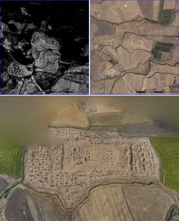
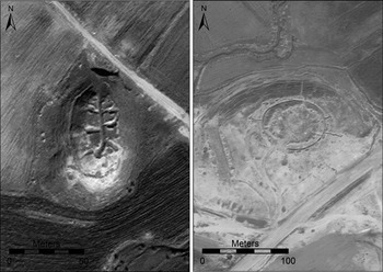
In the central Khani Masi Plain we find some of the densest Parthian and Sasanian settlement, including the site of Gawr Tepe (SRP11) where a large architectural complex is still preserved (Fig. 9). The rectangular building complex measures 340 × 220 metres, with numerous wall foundations clearly visible on satellite imagery. The centre of the complex forms a high citadel approximately eighteen metres above the plain, damaged by looting holes but which appears to have been a platform for a monumental building. Surface collection on the site suggests an occupation primarily in the Sasanian and early medieval periods. This building complex is surrounded by numerous smaller mounds, most of which also show contemporary occupation and thus are likely part of a sprawling urban settlement with Gawr Tepe at its centre. Some of these other sites, such as SRP 12 and 125, form prominent small mounds, and thus may also have been ancient monumental buildings. Other low mounds, such as SRP 124, are characterised by the presence of baked mudbrick but very sparse pottery or other artefacts, suggesting they are special use sites. To the south of Gawr Tepe are a number of contemporary sites including SRP 84, 85, 86 and 142 that contain abundant slag, fragments of large storage vessels, as well as grinding and mill stones, indicating that they may also be specialised sites for industrial production or agricultural processing.
Gawr Tepe, a major Sasanian city in the central Khani Masi plain as it appears in 1968 CORONA (upper left) and modern Google Maps served imagery (upper right). A 3D model of the central building complex (bottom), measuring nearly 350 m, was produced from kite photographs (imagery processing: Elise Laugier)

Throughout the rest of the Khani Masi plain, there are many other small Parthian and Sasanian period sites, some exclusively dating to those periods and others situated on top of earlier prehistoric and Bronze Age mounds. Indeed, it is difficult to find a mound that does not produce at least some evidence of minor Parthian/Sasanian settlement. The emerging picture of settlement in these periods is of a very densely occupied region, with the large city of Gawr Tepe at its centre and a vast network of smaller villages, farmsteads, and specialised production and processing sites throughout the region.
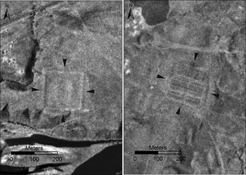
Some of the settlements we have recorded in the agricultural plain may have had a military function, but the clearest attestation of Sasanian military forts is found on the more arid stretch of the Diyala high terraces, between the more populated southern basins and the northern tributary valleys. Settlement in this area today remains sparse, but as a key communication corridor forming part of the Khorasan Road, a branch of the Silk Road into Persia and beyond, security for caravans and transport would have been a key concern. Several probable military forts of the Sasanian period have been identified, including SRP 9, a site bounded by a square fortification 180 metres on a side (Fig. 10). Although surface materials at the site were very sparse, the plan of the fortification walls conforms to plans common in the Sasanian period (Sauer et al. Reference Sauer, Omrani Rekavandi, Wilkinson, Nokandeh, Vagalinski and Sharankov2015a, Reference Sauer, Pitskhelauri, Hopper, Tiliakou, Pickard, Lawrence, Diana, Kranioti and Shupe2015b). We identified a similar feature on CORONA imagery further north on the east bank of the river, that is likely also to be a fort given the presence of several parallel banks of rooms characteristic of Sasanian military barracks (Fig. 9). Further north still, the modern village of Tazadee is home to a medieval caravanserai, Qalai Gawri (SRP 61), but surface collections on the mound show abundant Sasanian ceramics, suggesting it too may have once been a Sasanian fortress.
Probable Sasanian military forts at SRP 9 (left) and a still unrecorded site on the east bank of the Diyala, as seen on 1968 CORONA imagery

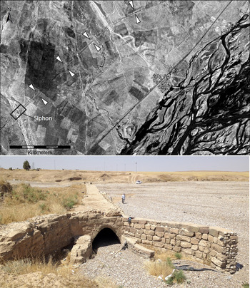
Parthian and Sasanian settlements were supported by an investment in irrigation that is unparalleled in earlier periods, enabling large areas that were uncultivated in previous periods to be farmed, while also boosting production in areas that had long been agricultural. One of the best examples of the scale of irrigation in these periods is a large canal system on the western side of the Diyala, mapped using CORONA satellite imagery from 1969 (Fig. 11). In this area a linear canal feature can be clearly traced, tapping Diyala waters north of modern Kalar and delivering the water more than forty kilometres downstream, where it was used to irrigate a plain on the west side of the valley. Today the canal that was visible in the 1960s has been mostly obscured by urban development around Kalar and agricultural intensification elsewhere, but even in areas where it is still visible on modern satellite imagery, it is very difficult to trace on the ground, evident only as a subtle linear depression less than 0.5 metres deep and around twenty metres wide. However, at points where the canal crosses a drainage channel, we have found remains of stone-lined siphons, which used water pressure to force water below seasonal drainages (Fig. 10). Water from the canal ultimately ran into a natural drainage and then was used to irrigate an area of around fourteen square kilometres. This canal represents a sizable investment in labour and is a testament to the capabilities of Parthian and Sasanian engineers to reshape the agricultural landscape.
1969 CORONA satellite image revealing a major likely Sasanian canal west of modern Kalar (top). Several stone built siphons are preserved where the canal once crossed seasonal drainages, including this partially reconstructed example (bottom)

Later Medieval, Ottoman and Modern periods
While our survey area was of undoubted importance in the late medieval and Ottoman periods, much of the archaeological record from these periods is likely obscured by modern settlements. Historic maps from the early twentieth century show that most of the towns and villages which are occupied today were also the key towns a century ago, and presumably have a long history of settlement previous to that time. Most major towns such as Kalar and Darbandikhan, as well as many villages, including Tazadee and Horen, possess historic buildings dating back several centuries at least.
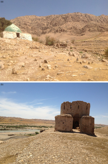
Religious shrines, often today in ruins, are among the most prominent remains of the medieval and Ottoman periods. The site of Imam Musa Kazm (SRP 145) on the edge of the Abbassan Valley for example is the site of many stone-built shrines, surrounded by hundreds of burials (Fig. 12a). The most recent shrine at the centre of the site is still maintained, but most of the older shrines, some probably several centuries in age, are today in ruins. Many other smaller shines are evident in the modern villages in this area, and some of these were already in ruins in the early nineteenth century, as reported by Rawlinson (Reference Rawlinson1839). Historic shrines have also been mapped at numerous sites in the southern basins, including at Tepe Kalan (SRP 18), where surface collection suggests that a medieval village once sat on top of the high mound at the site. Similarly, at Tepe Imam Mohammed (SRP 17) in the Khani Masi Plain a shrine sits at the base of the high Bronze Age mound, which has a later medieval settlement on top of it. A large medieval occupation is also located at the nearby mound of SRP 48.
(a) Ottoman period and earlier shrines and graves at SRP 145 in the Abbassan Valley. (b) Ottoman watchtower (SRP 63) on the west bank of the Diyala/Sirwan River

Perhaps the most visible Ottoman-period remains are a series of watchtowers (SRP 58, 59, 62 and 63) along the arid high terrace of the Diyala (Fig. 12b). Situated in the same region where the Sasanian forts are located, these watchtowers were built in a standard style, with a circular stone base approximately six metres in diameter. They appear to be quite regularly spaced along the axis of the valley at three to four kilometre intervals, and each tower has a clear line of sight to the next, which would have presumably facilitated rapid communication up and down the valley through flag or fire signals. During the Ottoman period, the Diyala constituted a contested boundary between the Ottoman Sultan's and the Persian Shah's respective spheres of influence (Ateş Reference Ateş2013), helping to explain the militarization of the river's west bank. These towers are in a rapidly deteriorating state, and several towers that are indicated on US military maps from the 1950s are completely gone. Extensive gravel mining in the Diyala valley bottom has greatly increased bank erosion in recent years, and so some towers appear to have simply crumbled into the river, while others are precariously close to the eroding bank today.
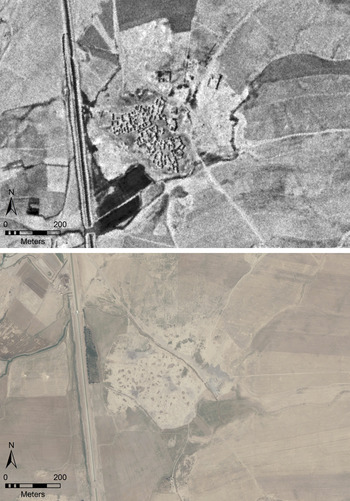
One final and sad note regards the archaeology of the modern period. Like some other parts of northern Iraq, many Kurdish communities in the Upper Diyala region endured brutal treatment by the regime of Saddam Hussein, particularly during the 1970s and 1980s (Hania and Bouckaert Reference Hania and Bouckaert2004). Tens of thousands of Kurdish residents of the region were killed during this period, and the regime's “Arabization” plan forced countless others to abandon towns and villages they had occupied for centuries. This terrible history of late twentieth century oppression is clearly evident in our survey region, as dozens of villages that CORONA satellite imagery shows were occupied during the 1960s and 1970s were abandoned during the 1980s (Fig. 13). Today these former villages appear quite similar to other archaeological sites in the region, as low mounds with rapidly eroding mudbrick house foundations barely visible at the surface, serving as a stark reminder of recent Kurdish history.
A Kurdish village as it appeared on CORONA satellite imagery in 1968 (top) is one of dozens that were forcibly abandoned during the 1980s, now appearing much like other archaeological sites (bottom) (GeoEye imagery © DigitalGlobe 2015)

Evidence of the military conflicts that resulted in such suffering among the local Kurdish communities is also evident throughout our survey region. It is difficult to find a mound more than a few metres in height that was not damaged by trenching or more substantial construction of military garrisons during the 1980s and 1990s. Ancient mounds are often located in strategic positions and are frequently the locations with highest ground and best visibility, making them tempting locations for military field commanders to fortify. In the worst cases military activities have obliterated mounds, with ten to fifteen metre deep trenches dug through sites, as at SRP 34, or produced cement-lined trenches and deep bunkers as at Tell Majid (SRP 39) and Tepe Ama Hosn (SRP 113; Fig. 14). The severe damage to the archaeological record evident in our survey area offers an example of the likely future for sites in Syria and northern Iraq, which today are being fortified and occupied by military forces in an even more intensive manner (Casana Reference Casana2015; Casana and Panahipour Reference Casana and Panahipour2014).
1980s and later military installations have done severe damage to many of the most prominent mounded archaeological sites in the region, as seen on 2011 and 2015 GeoEye satellite images of Tell Majid (SRP 39) and Tepe Ama Hosn (SRP 113; GeoEye imagery © DigitalGlobe 2015)

Conclusions and future directions
The initial three field seasons undertaken by the Sirwan Regional Project from 2013–2015 documented a large number of significant archaeological sites. We have begun to build a broader picture of the region's settlement history, and have highlighted key questions for future investigations. Prior to the initiation of our research in the Upper Diyala region, the archaeology of the area was almost completely unknown to modern scholarship, save for a handful of monuments and the location of a few large mounds. We now have a fairly good understanding of the region's environment and water resources, the overall density and distribution of ancient settlement, and typical trends in the preservation, morphology, and other characteristics of sites from various periods. We have shown that the region possesses an exceptionally rich record of prehistoric sites dating back to the earliest sedentary settlement in the Pre-Pottery Neolithic. We have also documented a number of significant Bronze Age urban centres whose historic identities are yet to be determined but which will no doubt warrant a reassessment of traditional reconstructions of political geographies in the years to come. We have also shown the region to possess a robust record of later settlement and irrigation, particularly in the Parthian and Sasanian periods. In addition, we have begun to recognise key distinctions in the settlement and material culture across different areas within the larger region, particularly for example in the sites that populate the upland plains flanking the Zagros foothills versus the expansive mounds of the low-lying irrigated basins in the south.
These findings are helping to shape our plans for future research in this promising region. One critical task, as discussed above, will be to refine the material culture sequence for the Upper Diyala through continued excavation at key sites and absolute dating of finds. It has become clear that a large portion of the artefactual assemblage in many periods is of a distinctly local character, with few ceramic types that can confidently be linked to other regional chronologies. This fact affects our ability to date occupations on the basis of surface collection, but also offers an opportunity to chart diachronic change in degrees of connectivity between the Upper Diyala and surrounding traditional centres of power. Our ongoing work will expand our approach of excavating targeted test soundings at key sites in order to build a better chronological sequence.
Our regional survey efforts will also continue, documenting more of the still hundreds of unrecorded mounds in the southern basins, expanding our work considerably in some of the upland plains, as well as exploratory pedestrian survey into the arid drainages to the west of the Diyala. Regional settlement survey will work in tandem with more site-focused studies, especially through geophysical prospection and aerial mapping in order to reveal potential distinctions in the built environments of settlements over time as well as in different areas. In addition, archaeological survey efforts will be closely coordinated with geomorphological and paleoenvironmental investigations in order to better clarify the ways in which the landscape has been transformed over the Holocene through both climatic and anthropogenic mechanisms.
Finally, we plan to begin expanded excavations at the Khani Masi site cluster, including at SRP 46 where extensive remains of Kassite-period monumental architecture are preserved just below the surface. Excavations at this site have the potential to transform our understanding of the social and political history of the region during the second millennium b.c., while excavations on other mounds within the site cluster will reveal cultural transformations and the dynamic history of highland-lowland connections among communities throughout this key region.