Mesoamerica is of special interest to anthropological archaeologists because it offers the possibility of studying how and why complex societies emerged. Features in common with other areas of the world where civilizations also arose in ancient times include a chronological-developmental sequence from hunter-gatherers to early agriculturalists, and the emergence of villages and eventually cities. Cities, or urban centers, provided a context for competition that resulted in cultural innovations such as writing, division of labor, social classes, military organization, and formalized religion. Ancient Mesoamerican civilization is actually an amalgam created through interaction among distinct ethnic groups in different areas, Veracruz, the Maya area, central Mexico, Oaxaca, west Mexico, and others, and thus we speak of Mesoamerican civilization, but also of Olmec, Maya, Aztec, Zapotec, Mixtec, and many other civilizations.
Mesoamerican civilization can be studied through particular cases which may have implications for the overall area and beyond. This paper focuses on one of Mesoamerica's earliest cities, Monte Alban, and specifically on questions related to Monte Alban's origins. Monte Alban marks the beginning of the urban revolution in Oaxaca and lends itself well to the study of urban origins because the temporal and spatial contexts are known. The city itself and the surrounding Valley of Oaxaca have been thoroughly surveyed by archaeologists, so population size and settlement distribution are documented. A solid chronological sequence exists for the region so the sequence of growth and change can be described. Founded on a previously unoccupied cluster of hilltops, there is no mixture of earlier archaeological materials, and in this sense Monte Alban is a pristine city. Excavated portions of the site have focused especially on public spaces and structures in and around the Main Plaza, the city's heart, though some residential areas have also been explored. The Monte Alban survey recorded 2,073 terraces and 21 areas (Blanton Reference Blanton1978:7, Appendix VI); most had at least one Late Classic household and many were occupied during several earlier periods. Thousands of households existed over the years in the city and only a few of these have been explored.
Several archaeologists have written about Monte Alban's origins, development, and collapse. Given ambiguities in the data and variation in theoretical perspectives, it is not surprising that differences of opinion exist. My intention here is to add another dimension to the discussion of Monte Alban's origins. The construction of Monte Alban, I argue, involved ideas about what a city should look like, a theme that has received little attention from archaeologists, at least in Oaxaca, and one in which social memory played a role. In addition, if the founding of Monte Alban is so important and so easily recognized by archaeologists, it seems reasonable that the ancient Zapotecs might also have recognized it as marking a new era and profound changes in their lives (Hamann Reference Hamann2002). Did the inhabitants of Monte Alban remember the founding of the city? If so, how was it remembered and what archaeological evidence exists?
Memory plays a fundamental role in the transmission and transformation of society (Rowlands Reference Rowlands1993), and has many dimensions in archaeology (Van Dyke and Alcock Reference Van Dyke and Alcock2003). I focus here on two aspects of early Monte Alban where social memory is relevant, the layout of the city's center and the carvings on the Danzantes Wall. While Monte Alban was founded in an entirely new setting, participants would have brought to the place memories of some past. Paul Connerton (Reference Connerton1989:6) writes in his book How Societies Remember, “[a]ll beginnings contain an element of recollection. This is particularly so when a social group makes a concerted effort to begin with a wholly new start.” Monte Alban's origins have occupied archaeologists’ attention for some time, but a major aspect of recollection, or social memory—a template used for the initial architectural layout of the center—has been overlooked. Application of the imported layout in itself implies transmission via memory—Oaxaca Valley Zapotecs may have seen, then recalled (or reinvented for themselves), and reproduced the urban design. Since many early structures at Monte Alban remain buried, the precise early core layout is in part hypothetical, based on other sites and later periods at Monte Alban itself. The surprising longevity of the pattern indicates that it was remembered over the years, not as private memory but as a basic element of the urban society.
The carved figures on the Danzantes Wall represent a different kind of social memory, not an abstract template but a material manifestation, like a photographic documentation, of a performance involving many participants in a ceremony commemorating the founding of the city. The memory is social in the sense of multiple participants and the public setting of the architectural monument. In Connerton's (1989:40) terms, the danzantes would be “images of the past… recollected knowledge of the past…conveyed and sustained by (more or less ritual) performances.” Unlike the site layout, the danzantes memorialize one or several specific historical moments somehow related to the city's founding. Also unlike the architectural template, the danzantes had a relatively short life span—the wall or monument was partially dismantled and the stones reused in buildings with the context and significance of the portrayed individuals erased or forgotten.
THE SETTING: TIME AND SPACE
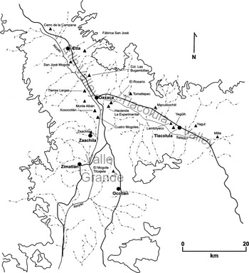
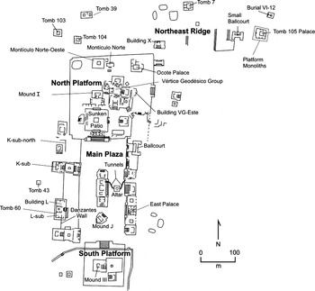
Monte Alban is located in the state of Oaxaca in southern Mexico, a mountainous region inhabited today, as in the past, by numerous indigenous groups. The Zapotecs, with about 500,000 native speakers, live today in the Valley of Oaxaca in the center of the state, the mountains north and south of the valley, and in the Isthmus of Tehuantepec region to the southeast. The Valley of Oaxaca is the largest of Oaxaca's highland valleys and judging by the unusually early, abundant, and precocious archaeological remains, including San Jose Mogote, Lambityeco, Mitla, Yagul, Zaachila and other sites as well as Monte Alban, was the Zapotec place of origin. At about 1,500 m (5,000 feet) asl, the valley has three main branches or sub-valleys: Etla, Tlacolula, and Zaachila-Zimatlan or the Valle Grande. The Atoyac River from Etla and the Salado River from Tlacolula meet in the center of the valley and continue south to the Pacific coast. Monte Alban and the present day state capital, Oaxaca City, are located in the center of the valley at the juncture of these rivers which is also the widest expanse of cultivable alluvium in the highlands (Figure 1). Human presence in the Valley of Oaxaca goes back at least 12,000 years to Paleoindian times. During the Archaic period (8000–2000 b.c.), hunters and gatherers passed through the region, and incipient agriculture was practiced. By 1500 b.c. villages existed throughout the valley and during the next millennium population increased and new settlements were established. Most pre-urban villages are located on the piedmont next to the alluvium of the main rivers. Around 500 b.c., some people moved to a distinctly new location, the top of a cluster of hills in the center of the valley about 400 m above the valley floor, which became Monte Alban. Within a few centuries the city had several thousand inhabitants, monumental structures, hieroglyphic writing and a calendar system, carved stone monuments, and clear social stratification. The intensely-occupied area of Monte Alban covers about 6.5 km2 and is dispersed on several ridge tops. The center of the city is the Main Plaza surrounded by large platforms that supported temples and residences (Figure 2).
Map of the Valley of Oaxaca with some of the sites mentioned in the text.

Map of the Monte Alban site center with Main Plaza and other structures indicated.

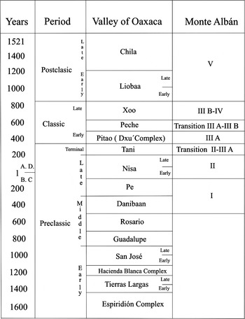
Two phases in the Valley of Oaxaca chronological sequence are crucial for understanding Monte Alban's origins. The Rosario phase (700–500 b.c.) precedes the founding of Monte Alban, and the Danibaan phase (500–300 b.c.) includes the time of founding and initial occupation (the first few generations) of Monte Alban. The Danibaan phase is followed by the Pe (300–100 b.c.) and Nisa phases (100 b.c.–a.d. 200), during which time this developmental trajectory continued (Figure 3).
Valley of Oaxaca chronological chart beginning with the period of sedentary villages.

MONTE ALBAN'S ORIGINS: SEVEN INTERPRETATIONS
By the 1960s, archaeologists had recognized Olmec and Mixtec elements in Monte Alban's earliest period of occupation and located its origins in those cultures (Bernal Reference Bernal, Willey and Wauchope1965; Caso et al. Reference Caso, Bernal and Acosta1967; Wicke Reference Wicke1971). We now know, however, that early Olmec culture flourished initially long before Monte Alban was founded, and that the earliest Mixtec urban centers began two or three centuries later than Monte Alban. Since the 1970s, explanations have focused more on local factors and processes, and at least seven different interpretations or models have been proposed to explain Monte Alban's origins.
Model 1: Rival Chiefdoms and Disembedded Capital
This model was proposed by Richard E. Blanton (Reference Blanton and Cleland1976) and has been further elaborated by Blanton and his colleagues Stephen A. Kowalewski, Gary M. Feinman, and Linda M. Nicholas (Blanton et al. Reference Blanton, Feinman, Kowalewski and Nicholas1999). It proposes that during the Rosario phase, each branch of the Valley of Oaxaca was dominated by one relatively large site or chiefdom: San Jose Mogote in Etla, El Mogote Tilcajete in Zaachila-Zimatlan, and Yegüih in Tlacolula. Surface survey shows that many but not all of the smaller sites in the valley, both hamlets and villages, clustered around these chiefly centers, implying economic and political interdependence. The model holds that the three large communities were in conflict. Monte Alban was founded on supposedly marginal land as a disembedded political capital, like Washington, DC., or Brasilia, to resolve conflicts, integrate the valley, and keep the peace.
The surface survey (Blanton Reference Blanton1978:37–39) identified Early Monte Alban I (Danibaan phase) ceramics in three areas around the site center, interpreted as manifestations of three founding populations from Rosario phase chiefdoms in the three valley branches. However, excavations during the Monte Alban Special Project 1992–1994 detected early occupation in an approximately contiguous area including the Main Plaza, the west side of the plaza, the North Platform and the Northeast Ridge. Extensive excavations of residences west of the South Platform, for example, revealed no in situ Danibaan or Pe deposits. Surface distributions of only a few diagnostic early sherds in some areas may reflect fill that was moved around and used in building construction. The founding population seems to have been concentrated on the west side of the plaza, the North Platform and terraces to the north and on the Northeast Ridge. More in line with this is Blanton's more recent publication which shows a single area of early occupation centered around the Main Plaza (Blanton et al. Reference Blanton, Feinman, Kowalewski and Nicholas1999: Figure 3.3).
The model has several problems. First, the territories of the three chiefdoms have not been defined with archaeological evidence and it is not known to what extent pre-Hispanic villages controlled “territories.” Second, if they were rivals or enemies, why and how would these three communities agree to send representatives to keep the peace and what advantage would they incur? Third, the implication that the chiefdoms split up, that some people went to Monte Alban and others stayed back, has not been demonstrated. Danibaan phase data show that households at Monte Alban had the same full set of features and implements as households elsewhere in the valley, implying that Monte Alban was a full-fledged settlement, not just a political center.
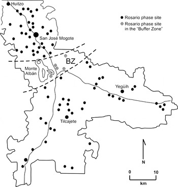
On the positive side, the model is testable, at least in part. The authors claim, based on their valley-wide surface survey, that the center of the valley was unoccupied during the Rosario phase and that it was a “buffer zone” between the chiefdoms. However, recent discoveries show that, on the contrary, there were several Rosario phase villages in the center of the valley. This area was not a buffer zone or no-man's-land, so this part of the model does not hold (Figure 4).
Map of the central part of the Valley of Oaxaca showing the supposed “buffer zone” with Rosario phase sites within it. Map after Blanton et al. (Reference Blanton, Feinman, Kowalewski and Nicholas1999:Figure 2.7).

Model 2: Market and Centralization
A second model states that Monte Alban was founded because it is in a central location to coordinate exchange among villages in the valley (Winter Reference Winter and Hirth1984). The central location and establishment of a market were most likely key factors and economic aspects were fundamental to Monte Alban's origins, though it is not exactly clear how. Blanton et al. (Reference Blanton, Feinman, Kowalewski and Nicholas1999; see also Feinman et al. Reference Feinman, Blanton, Kowalewski and Hirth1984) agree that there was a market at Monte Alban but have argued that it was located away from the site center, not in the Main Plaza as I maintain. Monte Alban's hilltop location may have made the market equally accessible to people approaching the city from different sides, for example, from Etla and Xoxocotlan. Oaxaca City today is also a market center for the valley, but without the hilltop location. Monte Alban's role in the Valley of Oaxaca economy was important but probably not the prime motivation behind its founding.
Model 3: Cultural Ecology
In separate studies, Robert S. Santley (Reference Santley1980) and William T. Sanders and Deborah L. Nichols (Reference Sanders and Nichols1988) argued that Monte Alban's location can be explained in terms of cultural ecological factors. Santley countered the disembedded capital hypothesis while Sanders and Nichols elaborated an ecological model based on details of land use, productivity and population size. Like Models 1 and 2, this interpretation is acceptable as far as it goes (in early complex agricultural societies correlations do exist between population size and agricultural resources such as soil and water). Monte Alban's specific form and the timing of its founding, however, are not explained.
Model 4: Synoikism
Borrowing a model from studies of Greek city-states, Joyce Marcus and Kent V. Flannery (1996:139–143) proposed that existing villages were brought together to form Monte Alban. They claim that the people from San Jose Mogote moved to Monte Alban and took others villagers along with them, supposedly to extend and expand their political control over the valley center. Synoikism simply means “urban relocation.” The scenario sounds reasonable but is not supported by the archaeological evidence. Marcus and Flannery (Reference Marcus and Flannery1996:128–130) argue that San Jose Mogote was attacked during the Rosario phase which in part motivated the change. This is questionable. If San Jose Mogote was the largest site in the valley, why was it vulnerable? Who attacked it? One burned building is not proof of a raid or an attack. They also argue that San Jose Mogote was abandoned after the Rosario phase and the inhabitants moved to Monte Alban. Surface survey data contradict this claim (Kowalewski et al. Reference Kowalewski, Feinman, Finsten, Blanton and Nicholas1989:89–90, Tables 5.3, 5.9, and 6.4), and although some people from San Jose Mogote may have moved to Monte Alban, survey and excavation data show that San Jose Mogote remained a populous and strong community in Danibaan, Pe and Nisa times. I return to this topic below.
Model 5: Ideology
An ideological explanation for the founding of Monte Alban has been argued most convincingly by Arthur A. Joyce (Reference Joyce, Dobres and Robb2000; see also Joyce and Winter Reference Joyce and Winter1996) who noted that that key problem at Monte Alban, given its location some distance from sources of water and prime agricultural land, was how leaders could attract and hold followers (What do followers get? How do they benefit?). This is explained by the existence of a covenant between humans and gods—humans practice sacrifice and offer blood in return for corn provided by the gods through the earth—a fundamental precept in the Mesoamerican world view. Little direct evidence exists at Monte Alban, though bloodletting possibly represented by the danzantes, first proposed by Javier Urcid (Reference Urcid1998:9), might support the argument. Related elements in an ideological perspective are the symbolism of the Main Plaza layout (north, water and fertility; south, warfare and sacrifice) and the idea of Monte Alban as a sacred mountain or mountain of sustenance (Joyce Reference Joyce, Dobres and Robb2000, Reference Joyce, Hendon and Joyce2004; Markens Reference Markens and García2011).
It is true that new ideological elements are present at Monte Alban, but not all of them were present from the start. Some material manifestations of religion appeared one at a time during the first centuries: representations in ceramics of deities, temples and ballcourts as new types of buildings, use of calendrical proportions in construction (Peeler and Winter Reference Peeler and Winter1995, Reference Peeler and Winter2010), and others. Religious elements came into play and increased after the founding of the city.
Model 6: External Stimulus
Blanton (Reference Blanton1978:40) noted that a military threat could have stimulated the formation of a federation in the valley. Blanton and his coauthors (Blanton et al. Reference Blanton, Feinman, Kowalewski and Nicholas1999:64) mention the possibility of “mountain dwellers” raiding Oaxaca Valley communities, resulting in political unification. The authors suggest that since groups in regions adjacent to the valley were small, outside pressure may have come from distant areas, and claim, without specifying why, that it is not likely to have come from the Basin of Mexico but more likely from Puebla, Morelos, Veracruz, the Mixteca Alta or the Isthmus of Tehuantepec (Blanton et al. Reference Blanton, Feinman, Kowalewski and Nicholas1999:64). However, clear evidence of such pressure is lacking. At least one area, the Mixteca Alta, can be ruled out during the Rosario phase since trade relations with the valley seem to have flourished (see below).
Model 7: Xoxocotlan Hinterland Defense
I propose this model to best cover available evidence. The best agricultural land in the Valley of Oaxaca is immediately to the east of Monte Alban where the valley's two main rivers merge. Monte Alban may have been founded by Rosario phase villagers from communities in the center of the valley to defend and control this land. The Monte Alban hills would have provided valued territory and a hinterland for some of these villagers, offering wood, game, spring water, and edible wild plants. The land itself may have been agriculturally marginal, as claimed in Model 1, but the hills supplied other basic resources.
Several lines of evidence support this model. First, the extensive, prime agricultural land east of the Monte Alban hills could have produced enough corn to support thousands of inhabitants at the city during the early centuries. Houses at Monte Alban were built on terraces with some open space probably used to cultivate rainy season corn crops and kitchen gardens. Second, evidence from excavations suggests that several villages in the center of the valley were abandoned after the Rosario phase; their inhabitants may have been some of the colonizers of Monte Alban: Xoxocotlan, Hacienda La Experimental, Tierras Largas, Colonia Las Bugambilias, possibly El Rosario, and others. Third, some of the earliest occupation at Monte Alban was on the Northeast Ridge overlooking the Xoxocotlan central valley area as well as portions of the Etla Valley. This is the only location near the top of Monte Alban that offers a view in both directions and would have permitted people at Monte Alban to spot intruders and monitor activities on the valley floor.
Five of the seven models attribute Monte Alban's founding to territorial control for economic or political reasons; the ideology and outside founder models are less coercive and more voluntaristic. In general, the models focus on population dynamics and political economy within the Oaxaca Valley and overlook a fundamental question of the origin of the idea of a city and what it should look like.
MONTE ALBAN'S CORE: ROSARIO PHASE ORIGIN?
Monte Alban's center consisting of the Main Plaza and adjacent structures reflects a planned physical layout, and, since the buildings were constructed over several generations, in some form the plan must have been known from the beginning. The original site nucleus, shown by Danibaan phase monumental construction, was the Main Plaza, delimited by buildings on its west side, and the North Platform. Buildings on the east side of the plaza, the central buildings, and the South Platform have all revealed some Pe phase constructions and may cover even earlier beginnings.
One possibility, commonly accepted by Oaxaca specialists, is that Monte Alban's antecedents are to be found in the Valley of Oaxaca itself, particularly at the site of San Jose Mogote, the valley's largest pre-Monte Alban community. A reevaluation of some existing data and interpretations show that this is not the case. The Rosario phase is defined by distinctive ceramics, especially grayware vessels with incised designs (the pennant motif, possibly derived from the Olmecs) and use of contrasting burnished and matte areas for decoration. Common grayware forms are conical bowls and beakers (at Fabrica San Jose). The earliest comales in Oaxaca and elaborately decorated bowls from Colonia Las Bugambilias and Hacienda La Experimental may represent innovations by potters in the valley center, foreshadowing the move to Monte Alban. Since Rosario phase ceramics do not occur at Monte Alban, it appears that a new, related ceramic complex was produced to accompany Monte Alban's colonization.
Rosario phase ceramic styles are also documented from two regions outside the Valley of Oaxaca: parts of the Mixteca Alta (Apoala, Nochixtlan Valley sites and some sites further south toward Achiutla), the Tehuacan Valley, and possibly near Zapotitlan Salinas, Puebla, although not, at least so far, in the Cuicatlan Cañada.Footnote 1 This distribution corresponds to what may have been an obsidian trade route from the Oaxaca Valley and the Nochixtlan Valley to sources in the Pico de Orizaba area of Veracruz. Interaction reflected in Rosario phase ceramic styles between communities in the Oaxaca Valley and the Nochixtlan Valley continued as exchange relations during the Danibaan phase (the Yucuita phase in the Mixteca Alta): cream (crema) paste vessels made near Monte Alban were sent to the Mixteca in exchange for fine brown (café fina) paste vessels made near Etlatongo and Yucuita (Joyce et al. Reference Joyce, Neff, Thieme, Winter, Elam and Workinger2006).
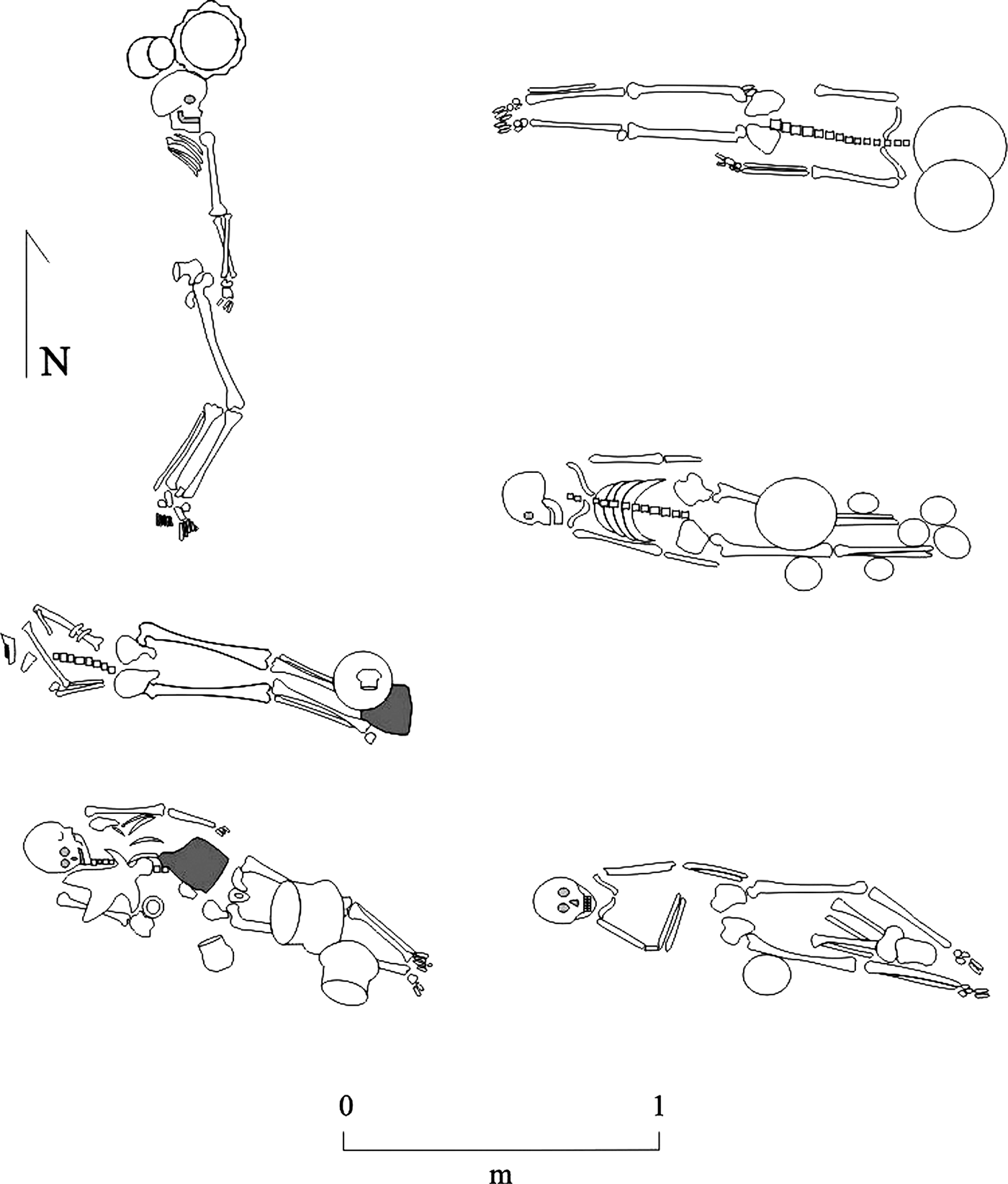
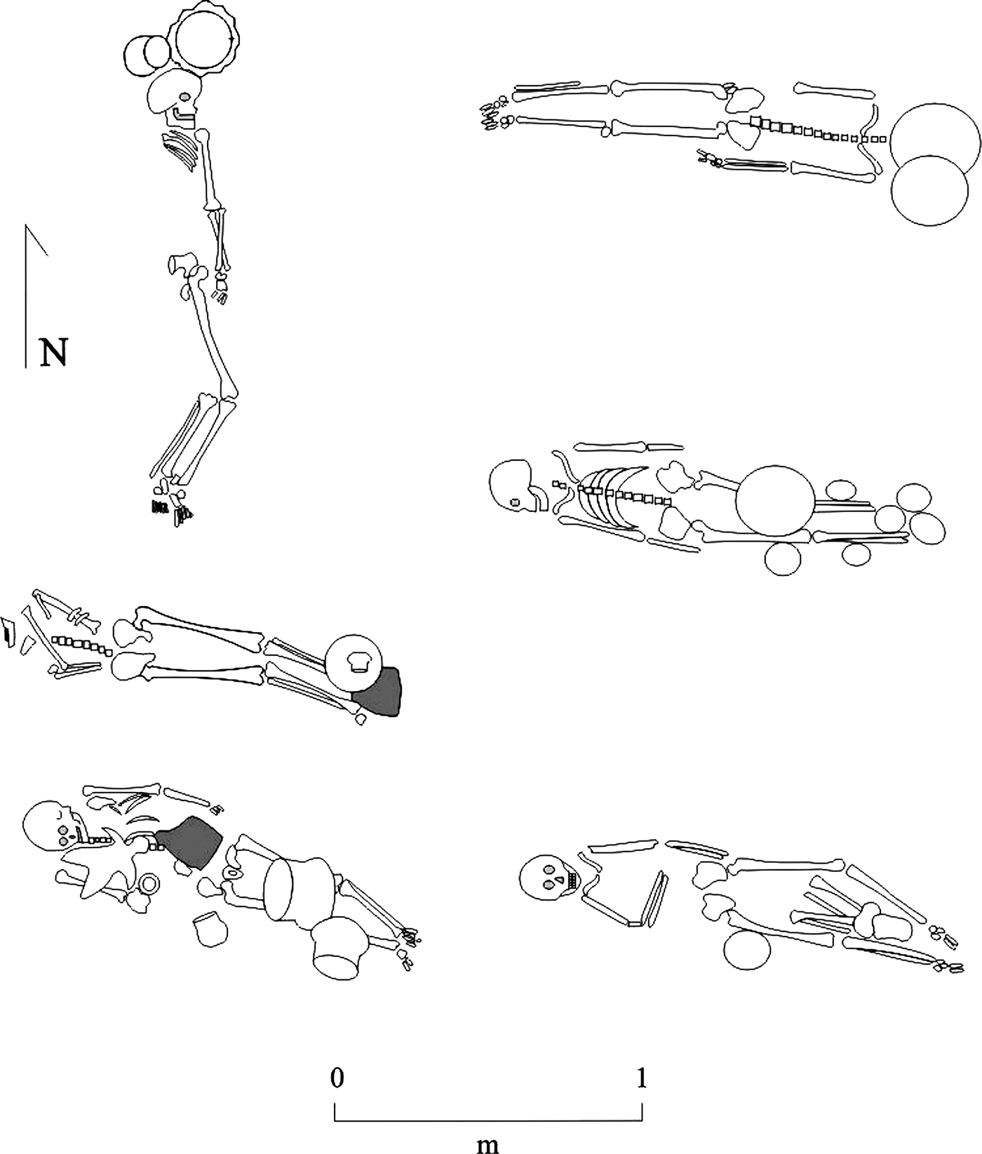
Approximately 85 Rosario phase sites have been located in the Valley of Oaxaca (Kowalewski et al. Reference Kowalewski, Feinman, Finsten, Blanton and Nicholas1989:69), mostly hamlets and villages of 3–10 households (15–50 people). Houses were of wattle and daub; subterranean bell-shaped storage pits occurred next to the houses as did adult burials, generally found in extended position accompanied by simple offerings of one or two vessels (Figure 5).
Commoner burials of the Rosario phase (left column; redrawn from Whalen [1981:Figure 44]) and the Danibaan phase (right column; redrawn from Drennan [Reference Drennan1976:Figure 84]).
The three large sites, Blanton's chiefdoms, may reflect more complex organization though only San Jose Mogote has been excavated in some detail. The Yegüih site near Tlacolula has some 180 mounds and an area with Rosario phase (and later Preclassic) material at the southeast corner, but few Rosario phase deposits have been excavated. The El Mogote site at Tilcajete, partially excavated by Charles S. Spencer and Elsa M. Redmond (2004), has both Rosario and Danibaan phase constructions but these periods need to be separated in order to judge the significance of the pre-Monte Alban occupation. At San Jose Mogote, Flannery and Marcus (1996) excavated extensively on top of Mound 1 at the south end of the plaza where they found Rosario phase and later material. A re-evaluation of the information leads to revised dating of some of the structures and features and different conclusions about the relation between San Jose Mogote and Monte Alban.
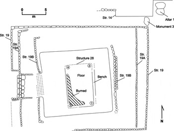
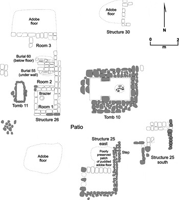
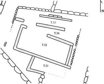
Flannery and Marcus (1996:126, 132) have published plan drawings of two groups of structures which they attribute to the Rosario phase. One plan (Figure 6), shows a rectangular platform with Structures 19, 19A, 19B and 28 separated from another platform, Structure 14, by a corridor. Structure 28 is interpreted as a temple with a burned floor. Monument 3, the San Jose Mogote danzante, was found placed flat in the corridor as a step and a large stone designated Altar 1 was found nearby. The second group of structures, found above the first group and considered later in time though still Rosario phase, includes Structures 25, 26, and 30, Tombs 10 and 11, and some other features (Figure 7). This group is interpreted as a residence.
San Jose Mogote; plan with Structures 19, 19A, 19B, and 28. Redrawn from Marcus and Flannery (Reference Marcus and Flannery1996:Figure 131).

San Jose Mogote; plan with residence showing several structures and features. Redrawn from Marcus and Flannery (Reference Marcus and Flannery1996:Figure 139).

Problems with Flannery and Marcus's dating of these features can be summarized in five points.
1. Structure 28 and its presumed outer east and west walls, called Structure 19B, show an 8° north-of-east orientation (Marcus and Flannery Reference Marcus and Flannery1996:126) which is documented in Oaxaca as far back as the Early and Middle Preclassic (Peeler and Winter 1991–1992). In contrast, Structures 19, 19A, and 14 have an east-west orientation (Marcus and Flannery Reference Marcus and Flannery1996:128) that appears in the Valley of Oaxaca when Monte Alban was founded (Peeler and Winter Reference Peeler and Winter1992–1993). If Structure 28 is Rosario phase, Structures 19, 19A and 14 are probably Danibaan phase or later since they exhibit the new Monte Alban orientation.
2. Structures 25–26–30 and Tombs 10 and 11 are not Rosario but Danibaan phase. Structure 19A may be the outer wall of the residence. These have the Monte Alban east-west orientation and include a primary deposit of ceramics in clear association with the architectural features, the only one reported and illustrated with the entire complex. It consists of five vessels found in Structure 26, Room 1, and although Flannery and Marcus (Reference Flannery and Marcus2005:409–443) date it as Rosario phase, it is Danibaan since all five vessels are similar to pieces commonly found at Monte Alban:
1. creamware cup (vaso);
2. brownware bowl;
3. white-slipped creamware (C.5) effigy brazier. Examples known from Monte Alban (see Winter et al. Reference Winter, Autry, Wilkinson, López and Winter1995:Figures 51–10 and 56-b) have a standard height and some have a band at the juncture of the bowl and the pedestal base;
4. creamware with red wash (C.2);
5. white-slipped creamware plate. The tombs, including the stone slab floor in Tomb 10, are also characteristic of Danibaan or Pe. Danibaan phase dates have been reported by Marcus and Flannery (Reference Marcus and Flannery2005) from this part of the site, although they do not specify from where the samples were taken.
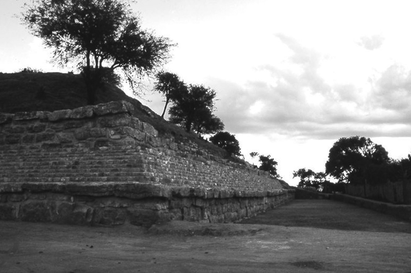
3. The north stairway and the north and west walls of Mound 1, uncovered and consolidated by Enrique Fernández (Fernández Dávila and Hueda Tanabe Reference Fernández Dávila, Tanabe, Uriarte and Lauck2008) several years after Flannery's project, are similar in style to early constructions at Monte Alban and Dainzu that incorporate large monoliths in vertical basal walls (Figure 8). Pe and Nisa phase ceramics, including both thin-walled and thick-walled G.12 rims and comb-incised bases, occurred in the fill removed to expose structures at San Jose Mogote. Neither the stairways nor the outer walls of Mound 1 show evidence of multiple construction stages and thus may correspond to one major construction program. Structure 19, the stairways (the narrow one on the west side and the main one on the north), the outer walls of Mound 1 and Structure 14 all correspond to the end of the Pe phase.
4. Structure 31. This “circular adobe platform, 6 m in diameter” (Marcus and Flannery Reference Marcus and Flannery1996:130–131, Figure 138) is interpreted by Marcus and Flannery as a possible dance floor. In fact, however, it was probably the base of a tall circular column like the Pe phase example found during Caso's excavations in the Small Ballcourt at Monte Alban (Peeler and Winter Reference Peeler and Winter2001) and part of the Pe phase construction program at San Jose Mogote. Damon E. Peeler and I believe the columns were used as sighting points between communities. The column in the Small Ballcourt at Monte Alban could have been used to sight to the column at San Jose Mogote.
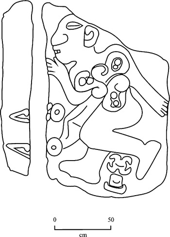
5. Monument 3, the danzante, also corresponds to the Pe phase for reasons previously described in detail (Cahn and Winter Reference Cahn and Winter1996): the stone is broken and it was moved from its original intended vertical position as a corner stone; it is not worn on the surface, hence it was probably not used as a step; and the triangle and dot iconographic element is known from the Pe phase as indicated by a shell ornament from Fabrica San Jose and the Early Ramos phase by a decorated ceramic piece from Yucuita and carved stones from Monte Negro. The trilobal heart glyph is known from the Nisa phase at Monte Alban (Figure 9).Footnote 2 The danzante was originally carved and placed during the Pe phase but was moved from its original position, probably toward the end of Pe or in the Nisa phase. Altar 1 is simply a large block fallen from the Structure 14 wall.
The northwest corner of Mound 1 at San Jose Mogote showing two vertical walls separated by a wall in talud. The large blocks in the walls and cornices are also characteristic of Danibaan and Pe phase buildings at Monte Alban and Dainzu.

Monument 3, the San Jose Mogote danzante. Redrawn from Marcus and Flannery (Reference Marcus and Flannery1996:Figure 137).

What does this mean? First, the peculiar disjunction between a supposedly precocious Rosario phase San Jose Mogote and everything else in the Oaxaca Valley is eliminated. Second, what was going on at San Jose Mogote in the Rosario phase was not as complex and monumental as we have been led to believe by Flannery and Marcus. Instead there was continuity from Rosario through Nisa times. We know from independent data that during the Pe phase, not Rosario or Danibaan, conflicts flared within the Valley of Oaxaca (Spencer and Redmond Reference Spencer and Redmond2004), and between communities in the valley and the Mixteca (Winter Reference Winter1989). The San Jose Mogote danzante, carved and placed as a vertical corner stone during the Pe phase, represents a specific event, the sacrifice of a man named 1L, possibly to commemorate the subjugation of San Jose Mogote by Monte Alban; 1L could name the captor or the sacrificer (Javier Urcid, personal communication 2011). During the Nisa phase this event was erased from memory as the stone was moved to a new position and used as a block to retain the fill in the corridor. Finally, while Flannery and Marcus envision a gradual increase in complexity from Rosario into Monte Alban I, my interpretation of the San Jose Mogote data shows that Monte Alban's founding represents a dramatic break with the past, manifested in architecture, building orientations, mortuary practices, and even ceramic vessels.
MONTE ALBAN'S CORE: IMPORTED TEMPLATE?
Another possibility is that Monte Alban's layout comes from outside the Valley of Oaxaca. John E. Clark and Richard D. Hansen (2001; see also Clark Reference Clark, Ruiz, de León and Martínez2001) have pointed out that La Venta and some early mounded sites in Chiapas share a common site plan, the Middle Formative Chiapas (MFC) pattern: “…a north-south axial arrangement of regularly spaced pyramidal platforms and plazas. The tallest platform or pyramid is located to the north…” (Clark and Hansen Reference Clark, Hansen, Inomata and Houston2001:4). Although comparison of these early sites is limited by lack of excavated architectural features, Monte Alban looks more like La Venta than Chiapa de Corzo, at least in Clark and Hansen's (2001:Figures 11.2 and 1.3) illustrations.
In another paper Clark notes that three early Mesoamerican cities—La Venta, Chiapa de Corzo, and Monte Alban—all share certain regularities: the same basic configuration, alignment to the cardinal directions, bilateral symmetry, harmonic proportions, fixed measurements, the same length intervals, and identical sizes (Clark Reference Clark, Ruiz, de León and Martínez2001:183). While lack of excavated evidence makes it difficult to evaluate some precise architectural details at La Venta and Chiapa de Corzo, Monte Alban's center does share La Venta's general north-south orientation (though precise orientations differ) and central plaza. Monte Alban's layout is not exactly the same as La Venta's; for example, the Stirling Acropolis at La Venta is not replicated at Monte Alban where there is no space for a wide platform on the east side of the plaza. In fact, it is not absolutely clear what is replicated. The Main Plaza with its flanking structures on the east and west along with the North Platform looks most like La Venta's Complex B with the rectangular plaza delimited by the acropolis on the east, three platforms on the west, a mound in the middle, and the high mound (C1) to the north (Clark and Hansen Reference Clark, Hansen, Inomata and Houston2001:Figure 1.2; also Gillespie Reference Gillespie2011). Given that parts of La Venta's and Chiapa de Corzo's central areas pre-date Monte Alban, these centers may have provided the model for Monte Alban's center which also implies that Monte Alban represents a break with the past, something new for Oaxaca. The center of the city (rectangular plaza flanked by residences and with a ceremonial precinct at one end) is the Monte Alban template (the north end of La Venta's Complex A may have been the model for sunken patios, for example at Teopantecuanitlan [Martínez Donjuan Reference Martínez Donjuan, Uriarte and Lauck2008] or Monte Alban's Sunken Patio on the North Platform).
Use of La Venta or the MFC model implies that someone, probably one or several Zapotecs from highland Oaxaca or Mixe-Zoques from the southern Isthmus, saw and remembered the La Venta layout. Thus the idea of a city center came from the Mixe-Zoque region or Greater Isthmus and was absorbed by Otomangue groups. The presumably Zapotec founders of Monte Alban selected a place with a potential long north-south rectangular area with a hill or rise at the north end. The natural Monte Alban hill itself constrained the layout since the hill drops off abruptly just beyond the buildings flanking the side of the plaza, and only at the north end was it practical to expanded the plaza's width by filling in with rubble.
San Jose Mogote provides an interesting contrast. In the Danibaan phase, the high status residence is still on top of Mound 1, unlike Monte Alban where the principal residences flank the sides of the plaza. By the Pe phase, San Jose Mogote shows the Monte Alban pattern because it was copied and replicated. A rectangular plaza was built with residences on both sides (only Tomb 12 has been excavated), and a ceremonial complex with Nisa phase temples, Structures 13, 35 and 36, constructed at the south end of Mound 1.
MONTE ALBAN'S EARLY OCCUPATION
The early occupation at Monte Alban should provide additional clues about the founding of the city. Primary deposits of Danibaan ceramics show that initial activity at Monte Alban was concentrated in and around the Main Plaza, the North Platform, the Northeast Ridge and on terraces north of the North Platform. Several types of deposits and structures have been registered:
1. Open plazas which would have functioned as meeting places and markets. The earliest example may be the plaza in the saddle on the Northeast Ridge while the Main Plaza may be slightly later.
2. Platforms with monolithic walls facing east. Buildings L-sub, K-sub and K-sub-north on the west side of the Main Plaza are the best examples.
3. The North Platform with high platforms, stone slab floors and relatively elegant ceramics detected beneath later constructions.
4. Residences with associated features as well as burials and tombs. Domestic unit UD1972-D1 on Terrace 634 about 1 km northwest of the North Platform had fragments of stone wall foundations, bell-shaped pits containing household refuse, and three associated tombs, Tombs 174, 175, and 176 (Winter et al. Reference Winter, Autry, Wilkinson, López and Winter1995). Tombs 33 and 43 and Burial VI-12, excavated by Caso and his assistants, were presumably associated with high status residences, and several other burials and tombs were probably associated with low status domestic units, although the residential structures were either not excavated or not reported.
In the Valley of Oaxaca, the beginning of urbanism is accompanied by a change in household organization. The number of household members may have increased compared to the Rosario phase, along with more storage volume and larger structures, a possibility that remains to be tested. The clearest evidence for change comes from burial patterns which now reflect a concern with permanence of place and time. Several cases suggest that the inhabitants intended to bury adult members in the same place even if they died at different times, an example of social memory at the household level. Most archaeologists are familiar with the tombs common among the Classic period Zapotecs which often contained several adult family members. The use of tombs in Oaxaca began in the Late Preclassic Danibaan phase with contiguous tombs which are groups of one or more individual tombs. One of the first examples was found on Terrace 634, mentioned above. Danibaan phase household UD1972-D1 existed during several generations. The residential structure itself was poorly preserved though associated bell-shaped pits and three tombs were found. A wide range of ceramic vessels was recovered including misfired vessels which suggest ceramic production in the area.
Two contiguous tombs were discovered on the same terrace. Tomb 174 was inside a large square excavated into the yellow sedimentary bedrock. The tomb (containing an adult female and four vessels) was formed by an adobe wall inside the square; the remaining space was not used but presumably intended for additional interments in the future. Tombs 175 and 176 were rectangular tombs dug into the bedrock and positioned end to end. Tomb 176 had 14 vessels and many shell ornaments. It had been looted in antiquity. Tomb 175 contained no artifacts; it had been looted or not used at all, perhaps intended for future use. In both cases, the tombs imply planning for inclusion of future household members. A place was set aside for the interments and future deaths were anticipated. Since the household was not of particularly high status, this may have been a widespread pattern.
The best example of early contiguous tombs comes from Yagul (Chadwick Reference Chadwick and Paddock1966). On Terrace F above the main site area were found an initial principal tomb and three additions (Figure 10), probably associated with a residence as are most tombs in the Oaxaca Valley. The spatial distribution of the tombs suggests that the place was chosen and used over several years if not generations. Associated grave goods were mainly ceramics—a variety of vessel forms and an effigy brazier with an Olmec-style mouth like the Old Fire God brazier from San Jose Mogote. The contiguous tombs and elaborate grave offerings suggest that this was a high status, chiefly family. At Macuilxochitl another high status Danibaan phase tomb had an offering of 15 ceramic vessels (López Zárate Reference López Zárate2008). These tombs contrast with simple Danibaan phase burials which also occur in the Valley of Oaxaca and are similar to typical Rosario phase burials. For example, at Santo Domingo Tomaltepec, Michael E. Whalen excavated five Danibaan phase burials of adult individuals in extended position in simple graves accompanied by one or a few ornaments, ceramic vessels or other objects (Whalen Reference Whalen1981:152).
Yagul; Danibaan phase contiguous tombs. Redrawn from Chadwick (Reference Chadwick and Paddock1966:Figure 1).

These data show that after the founding of Monte Alban, even some small villages (Yagul, Macuilxochitl) had chiefly families, which was not the case in the earlier Rosario phase. The founding of Monte Alban selected for emergence in villages of chiefly families whose leaders coordinated interaction with the urban center. High and low status families, such as the family on Monte Alban's Terrace 634, strove to maintain their status through social memory expressed as mortuary ritual, setting aside a place for their dead. In some cases, Yagul for example, the importance of the household was reflected by the use of a brazier with Olmec features, invoking the deities and grandeur of the past. The contiguous tombs are forerunners of Pe phase and later tombs in which a single structure was used for several bodies, as is the case, for example, with the Pe phase tomb (designated Burial 5) at Tomaltepec (Whalen Reference Whalen1981:90–95) which had an offering of 37 ceramic vessels, including many bridge-spout jars used by the chief and his guests during ceremonies.Footnote 3
The early Oaxaca Valley tombs were opened in ancient times, as shown by examples from Monte Alban, Yagul, Macuilxochitl, and Tomaltepec in the case of Burial 5, the Pe phase tomb. In each instance, ceramic vessels were moved from their original positions, and it seems likely that greenstone or jadeite ornaments were removed, since similar objects are found with Rosario phase burials but not with the Danibaan examples. This may represent desecration and erasure of social memory, or change instigated by the family itself, perhaps for removal and safekeeping of the grave items.
PALACES AND RULERS’ RESIDENCES AT MONTE ALBAN
The data on Danibaan phase residences at Monte Alban do not indicate where the ruler or rulers lived. A reasonable hypothesis is that during early periods, Monte Alban's leaders lived on top of the North Platform. Here we have found early architectural elements such as a drain, a high platform wall, and a paved stone floor, but no definitive evidence of an early residence, which if present would be buried beneath later constructions. Blanton (Reference Blanton1978:61–62), for example, suggested that Monte Alban's highest ranking family occupied what is now the highest mound group (the Vértice Geodésico group), on the North Platform and received ambassadors and visitors in the nearby complex to the southwest (Mound I and the adjoining patio to the south). However, both of these are TPA (temple-patio-altar) religious complexes rather than residences. Some residences do exist on the North Platform, though most date from the time of the Teotihuacan occupation and were inhabited by Teotihuacanos: the Palacio del Ocote, the Montículo Norte, the Montículo Norte-Oeste, and the structures to the south of Building A (Winter Reference Winter and Rattray1998). Two medium-size Xoo phase houses flank the north and south sides of Mound VG and may have been occupied by priests in charge of the VG group. With few exceptions, the absence of burials and tombs on the North Platform also shows that it was not used for residences.
For the Late Classic Xoo phase, the most likely candidates for rulers’ residences are five palaces, all with large tombs, located to the north and just below the North Platform; from west to east, the palaces of Tomb 103, Tomb 104, Tomb 39, Tomb 7, and Tomb 105. All are similar in size and format, but show some important differences. Only Tomb 105 has painted murals depicting processions of named adult males and females. It is analogous to Lambityeco's Tomb 6 Palace with male and female portraits in the friezes in the patio and on the altar (Lind and Urcid Reference Lind and Urcid2009). Therefore the Tomb 105 Palace is the best candidate for a royal family residence, while the other palaces at Monte Alban may have been occupied by lesser nobles or other officials.
An additional argument supports this interpretation. The Tomb 105 Palace is located on the Northeast Ridge, precisely where, as mentioned above, some of the most important early constructions were concentrated, such as the high status Pe phase interment, Burial VI-12, on the ridge to the north and presumably associated with a residence. Interestingly, the Tomb 105 Palace is on a platform walled with large monoliths, the kind that were used only during the earliest phases (Danibaan, Pe and Nisa) at Monte Alban and elsewhere in the valley at Dainzu and San Jose Mogote (Figure 11). Thus the Tomb 105 platform may have been built during the Danibaan phase, a possibility that could be tested with excavation. Alternatively, the monoliths might have been quarried and set up during the Xoo phase. In either case the location and the construction style seem to be references, a kind of social memory, to the early occupation and construction style at Monte Alban. On the other hand, at least two Late Classic (Xoo phase) tombs in the valley are larger and more elaborate than the tombs associated with the palaces north of the North Platform at Monte Alban. One is Tomb 5 at Cerro de la Campana Suchilquitongo, Etla, the largest and most elegant Classic period Zapotec mortuary structure known (Franco Brizuela Reference Franco Brizuela1993). The tomb is literally a house of the dead: the architectural plan resembles a residence with a central patio, an entrance from the south, and rooms on the west, north and east sides. Carved stone door jambs, polychrome wall paintings, ceramic sculptures and a carved stone slab commemorate over 200 years of the noble family and depict processions of ballplayers, priests and named members of the family (Urcid Reference Urcid1992). The other also had many offerings and painted murals and was discovered years ago at the Cuatro Mogotes site in Santa Cruz Xoxocotlan on the alluvium east of the base of Monte Alban (Urcid and Sellen Reference Urcid and Sellen2008). The tombs associated with the palaces at Monte Alban seem simple and modest in comparison. Given Monte Alban's size and importance, one could argue that it should have tombs as large an impressive as those at Suchiquiltongo and Xoxocotlan.
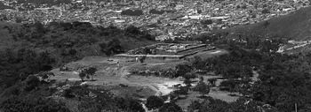
Palace of Tomb 105. The palace is built on top of a square platform with monolithic walls on the west side visible in the foreground in the photo.

Urcid (personal communication 2011) hypothesizes that the tombs are beneath temples on the North Platform, the only sector of Monte Alban with carved stones displaying representations of glyph U which he associates with Zapotec funerary rituals. This may be true; portions of the North Platform remain unexplored, even after Caso's many excavations on the North Platform and those of the Monte Alban Special Project, 1992–1994.
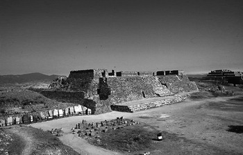
Two other possibilities for rulers' residences at Monte Alban are the East Palace and Building L facing each other on opposite sides of the Main Plaza. Building L is a large Xoo phase residence associated with cruciform Tomb 60 built above the Danzantes Wall (Figure 12). During the Xoo phase, this structure and adjacent space was walled off and separated from the plaza. Again, just as in the case of the Tomb 105 Palace, the ruler's dwelling is located on a place revered for its connection with Monte Alban's origins over a thousand years earlier. The East Palace is approximately the same size as the previously mentioned Xoo phase palaces but includes a medium-size house to either side and lacks an associated tomb, thus burials must have been made somewhere else. Exactly what structures were present beneath Building L and the East Palace is not known.Footnote 4 The elegant tombs mentioned above correspond to the Peche and Xoo phases; earlier mortuary patterns may be different. Given the principle of architectural continuity, in itself a manifestation of social memory, Zapotec leaders in Danibaan, Nisa and Tani times may have been buried in association with their houses in unexplored portions of the east and west sides of the Main Plaza.
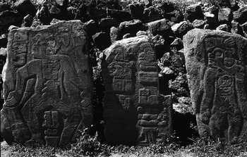
Building L with a row of danzantes to the left.

Examples of twin high-status residences on opposite sides of a plaza, as at Monte Alban, are documented at two Mixteca Alta sites, where later construction did not hinder exposure of early deposits. At Yucuita in the Nochixtlan Valley, an Early Ramos phase elite residential complex at the site center consisted of a central plaza-patio open to the south and flanked on the east and west by residential structures and on the north by a temple platform. This architectural complex, probably occupied by the principal chiefly family at Yucuita, combines an open space for exchange and administration (the plaza-patio), a ceremonial structure (temple), and the elite residences. The urban center served several outlying satellite communities situated on piedmont slopes from one to several kilometers distance from the center. At least one of these, the outlying site, La Loma, about 1 km east of the main site and designated Area M in the 1980 excavations (Robles García Reference Robles García1986), replicated the pattern of the central site. Here, single-room residences were dispersed on the hillside and a large structure was situated at the base of the hill directly across from the Yucuita center, consisting of a central plaza-patio open to the west facing the main site center with a niche (a shrine analogous to a temple) in the east wall and a residence on both the north and south sides of the plaza-patio. Both residences were closed format (a central patio flanked by lateral and corner rooms), and much larger and fancier than the single-room hillside houses.
A similar pattern occurs at Huamelulpan, another Mixteca Alta site. On the highest point of the main site sector, the Church Group, is a plaza-patio with a temple at the east end and high status residences on the north and south sides. The plaza-patio is open to the west and faces a wide stairway leading down to an extensive open plaza, a probable market area. This example is clearest for the Huamelulpan III (Classic) period though it has an underlying Late Preclassic component, presumably with the same layout. At Huamelulpan, as at Yucuita, satellite communities are located in the surrounding hills and again may reflect the same architectural pattern.
At both Huamelulpan and Yucuita the central plaza-patio complex with adjoining structures was the seat of the elite-administrative chiefly family. How the outlying high status families related to those in the main site center is unknown. One possibility, following ethnographic data from Oaxaca, is that a council of elders or leaders existed, made up of chiefs of satellite communities and headed by the paramount leader at the central community. The two high-status residences flanking the plaza-patio are not identical twins but vary somewhat and may have housed families of different status and responsibilities. Location next to the plaza-patio and near the temple facilitated control of both.
I believe the same pattern occurred at Monte Alban. In other words, the ruling family lived on both sides of the Main Plaza, controlled activities in the plaza, and directed and performed ritual activities carried out in the North Platform ceremonial precinct. During the Late Classic, the two residences, Building L and the East Palace, differed architecturally: compared to Building L the East Palace structure is larger, more expansive, on a lower platform and has a wider access stairway. The occupants of the two palaces must have had separate roles in Monte Alban's leadership. Chiefly leaders in the outlying, spatially distinct sectors of Monte Alban as well as in smaller communities in the valley participated at Monte Alban in ceremonies and political decisions, may have rendered tribute in goods, and attended the market. Some early participants at Monte Alban are depicted on the carved stones known as the danzantes, and this links Monte Alban with other sites in the Oaxaca Valley.
THE DANZANTES AND MONTE ALBAN'S ORIGINS
From the beginning of the Danibaan phase or shortly after, the Main Plaza as a large open space was Monte Alban's principal meeting place and market area. Among the oldest structures here are rubble cells placed to level and extend the plaza laterally to the east and west, and two tall platforms faced with huge monoliths, the Danzantes Wall which is the south part of Building L-sub now partly beneath Building L, and Building K-sub to the north, later covered by Building IV, which defined the west side of the plaza.
The danzantes (“dancers”) are representations of men carved on the monoliths that formed the exterior, east-facing southern wall of Building L-sub. Most of these stones were removed from their original contexts in pre-Hispanic times, though the Danzantes Wall proper preserves part of the original sequence as well as the stones known as Stelae 12 and 13 (Figure 13).Footnote 5 Many archaeologists accept the interpretation that the danzantes represent slain captives (splayed out bodies with closed eyes) and are a manifestation of Monte Alban's military power, designed to intimidate and control the populace of Monte Alban and neighboring communities (e.g., Coe and Koontz Reference Coe and Koontz2002; Marcus and Flannery Reference Marcus and Flannery1996). However, a closer look suggests this view is oversimplified at best.
Examples of two danzantes (D-55 on the left and D-59 on the right) and Stela 15 (center), removed in ancient times from their original placement in the Danzantes Wall at Monte Alban. Danzante D-55 depicts a high status individual as indicated by the glyphs in front of his face, on his torso, and between his legs. D-59 is unusual because it lacks the genital mutilation characteristic of many other danzantes.

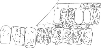
The 300-plus danzantes reflect several distinct styles and correspond to several programs or sets of images, possibly from more than one building and still incompletely understood (but see Urcid Reference Urcid, García and Guzmán2011; Urcid and Joyce Reference Urcid and Joyce2011). Those still in situ in the Danzantes Wall, the main group, include horizontal figures known as “swimmers,” carved on relatively small stone blocks alternating with vertical figures (danzantes) on large monoliths. The latter occur in groups in similar positions: standing facing right, standing facing left, crouching facing right, and so on (Figure 14). Some figures, but not the swimmers, are accompanied by glyphs, possibly symbolizing their names. Most show genital mutilation, a circle instead of a penis, and blood flowing out on their inner thighs. Taken literally, these danzantes may represent processions of enemies whose penises and testicles were cut off, reminiscent, of Egyptian battle scenes in which a pile of severed penises attest to defeated enemies (an effective way of limiting their reproduction). However, taken figuratively, and following Urcid's (1998) reading, these danzantes may portray genital bloodletting by participants in a ceremony.
Danzantes in original context in the Danzantes Wall. Redrawn from Scott (Reference Scott1978:Part I, Frontispiece).

Building L-sub is part of a platform base; the stones in each horizontal row are fairly regular and like the Building K platform originally may have been undecorated. The carvings form a commemorative monument and the structure once on top of the platform, although not preserved, would have been a leader's residence. The wall may have been constructed initially sometime in the Danibaan phase, and the figures carved later at the end of the Danibaan phase or beginning of the Pe phase. Javier Urcid (personal communication 2011) believes the wall and carvings were part of the same construction program. The decorated wall was presumably “read” in serpentine fashion from bottom to top, commemorating a historical event (or events), possibly the seating of a ruler (Urcid Reference Urcid, García and Guzmán2011), and involving many individuals depicted as groups of participants in a kind of ceremonial procession. Some individuals are commoners, others are chiefs with their names and perhaps their rank indicated. Urcid (2011) argues that the horizontal figures represent ancestors and the vertical ones members of an age-grade sodality. Archaeological correlates may exist for these individuals. The chiefly burials and tombs found at Monte Alban and other Oaxaca Valley sites mentioned above may actually correspond to some of the individuals depicted in the carvings. Ceramic vessels with danzante-like figures (Winter et al. Reference Winter, Autry, Wilkinson, López and Winter1995:Figures 50-6 and 54), probably abstractions rather than individuals’ portraits, found at Monte Alban and at sites in the Mixteca Alta and the Isthmus region may have been used in ceremonies like the one depicted by the danzantes, or may have served as reminders of the Monte Alban carvings and what they commemorated. In either case, they may also imply participation by a wider group than those who actually visited the city.
Four danzante-style carvings (originally incorporated in one of the programs) depict severed heads, suggesting that human sacrifice by decapitation was another aspect of the ritual. Archaeological data including skull-less burials, perforated crania, and obsidian knives from the Oaxaca Valley, the Mixteca Alta, and the Isthmus attest to the taking and display of trophy skulls at this time. Rain, lightning, and water symbolism were major elements in early Zapotec religion, as in other Mesoamerican religions, because corn provided people with sustenance, and water in the form of rain which came and went each year during the rainy season, provided sustenance for corn. A depression in the bedrock covered by a thick natural layer of clay allows water to collect here and form a small pond directly in front of the Danzantes Wall, which may explain why the particular location was chosen for portraying the procession, ritual bloodletting, and human sacrifice.
The most remarkable aspect of the monument is the great number of participants. If the swimmers represent ancestors, as Urcid (Reference Urcid, García and Guzmán2011) argues based on their horizontal position, then the Danzantes Wall depicts dead founders (the swimmers) and live celebrants (the danzantes). Both groups were imagined and remembered going back years, if not generations, into the past. It might be taken as recognition that many individuals participated in the formation of the urban center, even if subordinated to a leader. This contrasts with monuments that laud and depict a single isolated ruler. A variation on this would be the original structure that displayed the conquest slabs now found on Mound J: an inventory not of individuals but of towns and their corresponding leaders that were under Monte Alban's control by the Nisa phase (Urcid and Joyce [2011] offer a different interpretation of the Mound J slabs, arguing that they originally may have covered the Danzantes Wall).
The Danzantes Wall and related structures were in use for at most a few generations and then the walls were largely dismantled, and like K-sub, eventually buried beneath a later structure. The memory of specific individuals and dates was lost, but the place and general idea of origins were not forgotten.
DISCUSSION
The founding of Monte Alban signified many changes in the Valley of Oaxaca and more than just a move to a new place. New building orientations, new vessel forms, new symbols on ceramics, use of a calendar, and new, Zapotec-style writing on commemorative monuments all appear in the Danibaan phase. The layout of the city's core was also new and probably borrowed from earlier Mixe-Zoque settlements. One could argue that the founding of Monte Alban was a millenarian movement, a theme that merits further research.
As a new kind of settlement, Monte Alban represents a reordering of the universe, at least the social universe. The new order is reflected in the core layout with the leaders of society living on both sides and thereby symbolically controlling the populace by way of the marketplace and by presiding over public religious ceremonies carried out nearby in a separate precinct to the north.
The presence of the same architectural template at the Mixteca Alta sites of Yucuita and Huamelulpan confirm and reinforce its underlying importance, as does the transmission of the template from the Tani to the Peche phase despite the Teotihuacan hiatus. The layout continued at Monte Alban through the Late Classic, although elsewhere in the Valley of Oaxaca Late Classic centers have a modified version with a nucleus consisting of a palace, a TPA, a ballcourt, and a market area.
The danzantes and the Danzante Wall show a different kind of memorialization. The foundation of Monte Alban had repercussions in a restructuring of household and community organization manifested in mortuary practices with emphasis on adult family members. Some of these same individuals may have been commemorated in the public setting of the Danzantes Wall on the Main Plaza at Monte Alban. The carvings on the Danzantes Wall emphasize specific individuals, and communal participation in a particular event, possibly the seating of a ruler, thus legitimizing the city's existence. The danzantes represent and elicit memory of the participants in the founding, shown not as static men like many later figures, but as actors in a ceremony or procession that may have been reenacted, perhaps seasonally or at some other interval. Since the building was soon dismantled and the stones reused, the story or memory must have changed, or have been supplanted by a newer version, perhaps one implied by the conquest slabs. Both the danzantes and the conquest slabs reflect public acknowledgement and memory of the participation by many individuals and communities in the early years of Monte Alban. In both cases the complete narrative may have been on public display for no more than a few generations. As in modern times, memories of specific events and individuals transmitted verbally or even materialized with statuary last no more than a few hundred years before becoming vague, mythologized, forgotten, or erased. The actual elite residences on the Main Plaza, in contrast, were not narratives but places that were formed as part of the city's initial conception, part of an earlier Mixe-Zoque architectural template adopted, modified and applied at Monte Alban. To return to the question posed at the beginning of this paper, “Did the inhabitants of Monte Alban remember the founding of the city?,” the answer is a qualified yes. More excavation is needed to confirm the hypothesis but there appears to be remarkable continuity at the site, possible only because people remembered, repeated, and respected the city's origins.
RESUMEN
La fundación de Monte Alban marcó el inicio de la revolución urbana en Oaxaca, la reorganización de la cultura y de la sociedad zapoteca y un poco más tarde cambios entre los mixtecos y otros grupos otomangues en los altos de Oaxaca. Mientras que factores locales contribuyeron a los orígenes de Monte Alban, la expresión arquitectónica del núcleo de la ciudad, que consiste en una plaza principal con residencias de los líderes en cada lado y un conjunto ceremonial en un extremo, proviene del área mixe-zoque, probablemente de La Venta o de los altos de Chiapas. El Muro de los Danzantes se cuenta entre los monumentos arquitectónicos más tempranos en Monte Alban con piedras grabadas que retratan participantes en la fundación, incluyendo numerosos jefes de comunidades en el valle, como fueron interpretados, imaginados y representados por el líder o los lideres de la ciudad, años después del evento. El muro tuvo una vida corta: unas generaciones después de ser completado fue parcialmente desmontado y las piedras grabadas reutilizadas, así borrando el significado original del narrativo. En contraste, los elementos fundamentales del trazo del núcleo de la ciudad persistieron como el patrón (template) en la memoria social, por lo menos hasta el final del clásico tardío, repetido a veces con modificaciones en Monte Alban y en otros lugares, de cómo debe de ser una ciudad.
ACKNOWLEDGMENTS
I thank Raúl A. Mena Gallegos, Liliana Carla Reyes González, and Cira Martínez López for help in preparing the illustrations, and Gonzalo Sánchez Santiago and Ismael Vicente Cruz for correcting and digitalizing the final versions. I thank Jeffery P. Blomster, Robert Markens, Adam Sellen, Javier Urcid, and an anonymous reviewer for their helpful comments on a previous version of the manuscript.