

Introduction
Analysing conflicts in the 21st century reveals a paradigm shift. In the past, violence, in its different manifestations, seemed to be rooted in political, geostrategic or ideological frameworks. However, this vision is changing. Conflicts are increasingly complex,Footnote 1 and their triggers and consequences are intricately linked to climate,Footnote 2 environmental degradationFootnote 3 and the struggle to control a finite pool of natural resources.Footnote 4 More and more, the scientific literature confirms that climate change triggers or aggravates security threats,Footnote 5 such as food insecurity, which are linked to different types of conflicts.Footnote 6 The current scientific literature does not display an exact consensus on the interface between climate and conflict. Yet, there is a generally accepted view that climate is a threat multiplier. The United Nations Security Council debates its impact on peace,Footnote 7 but failed to pass a resolution on climate change and security because of the use of veto, whilst the Biden administration has made it official that “climate change will be the center of [U.S.] national security and foreign policy”,Footnote 8 despite the fact that exact mapping of this relationship remains elusive. Systemic and highly contextual lenses are needed to capture the whole set of direct and indirect channels and feedback loops across different existing risks and insecurities to accurately represent the highly intertwined relationships across the entire climate–security nexus.
Often, the poorest and most marginalized groups in society are overexposed to climate hazards and suffer the most from the impact of social, economic and political insecurity.Footnote 9 The climate crisis is a multifaceted reality and, against this background, many pressing priorities, such as food security, adaptation, mitigation, economic growth and development, compete with each other. The disruptive effect of climate variability and change on food systems is particularly acute and constitutes a direct and tangible threat to livelihoods globally.Footnote 10 Food is a basic human need, and climate variability and change place it at risk for millions of people, which translates into potential pathways to conflict and violence. One can conclude that in the large spectrum from conflict prevention to peacebuilding, disruption of food systems and the ensuing devastating consequences for food security register as key elements within any conflict analysis or policy. This raises a fundamental question: Does current peace and conflict thinking integrate climate and food systems viewpoints? The answer is no or not enough. From a systemic perspective, the intricate linkages between climate, food systems and conflict call for a dynamic integration of diverse sources of knowledge to develop new strategies that address the root causes.Footnote 11 The strained resilience of vulnerable populations, exposed to higher risks of disease, insecurity, hunger and violence, requires new approaches to counter those trends.Footnote 12 Additionally, beyond the humanitarian realm,Footnote 13 the institutional security architecture overseeing climate dynamics,Footnote 14 and the policies it generates, should be adjusted to address the complexity of conflicts rooted in the lethal combination of climate and environmental changes and faulty governance.Footnote 15 Food systems in a climate crisis are a key component for the 21st century's peace and security operations, policy and finance.
The semi-arid transitional zone between the Sahara Desert and the savannas to the south, known as the Sahel, is one of the most fragile regions in the world.Footnote 16 The Organisation for Economic Co-operation and Development (OECD) comprehensively assesses the fragility of states in relation to political, societal, security, environmental and economic fragility. The OECD characterizes all Sahelian countries bar Senegal as either fragile or extremely fragile.Footnote 17 There is a microcosm of localized conflict driven by natural resource scarcity and ethnic identities.Footnote 18 An overwhelming majority of conflicts along the semi-arid regions arise locally.Footnote 19 Increasingly variable seasonal weather cycles have pushed traditional herders and farmers of different ethnic groups towards the edge of their communal resilience.Footnote 20 The impact of climate variability on basic subsistence conditions first became apparent during the devastating twenty-five-year drought in the Sahel from 1968 to 1993, which destabilized rural livelihoods and sparked a major humanitarian crisis.Footnote 21 Food systems, including agriculture and livestock, are heavily reliant on sufficient precipitation, meaning that variability and climate extremes will contribute to crop failures and livestock deaths, causing economic losses and undermining food securityFootnote 22 and may exacerbate tensions and conflicts.Footnote 23
The objective of this paper is to demonstrate and discuss the importance of food systems under a climate crisis in exacerbating conflicts in the Sahelian region and propose interventions beyond and complementary to the usual military and security solutions. We firstly present climate hazard and exposure maps, climate and conflict hot spots maps and describe pathways on how climate exacerbates food systems and increases the potential for conflict and grievances. Secondly, we analyse existing peace indices, their shortcomings in addressing the climate and food systems dimension and how they compare to indices of food security, climate exposure and vulnerabilities, to showcase the importance for peace. Thirdly, we present examples of current research and development (R&D) in agricultural and food systems activities and their potential to strengthen resilience, peace and security across the Sahel. We conclude by classifying R&D agriculture and foods systems activities according to their drivers of conflict.
Results Chapter 1: Climate and food system drivers of conflict
Sahel: A climate-stressed region
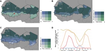
Agriculture and livelihoods in the Sahel are dangerously exposed to a plethora of climate hazards. To understand the extent to which different hazards occur across the Sahel under future climates, we mapped their occurrence using a combination of geospatial data and modelling approaches. We considered a total of four hazards, namely, drought, high temperatures, waterlogging, and precipitation extremes. Drought was calculated using the Thornthwaite aridity index (THAI) and the number of days with water stress (NDWS). Heat stress was computed using the number of days above 40°C (HTS, crops), the thermal–humidity index (THI, for cattle)Footnote 24 and the heat index (HI, for humans).Footnote 25 Waterlogging was computed as the number of days in which the soil is above field capacity (NDWL) using a simple water balance modelFootnote 26 driven by daily meteorological data and soil hydrological properties (from SoilGrids1km).Footnote 27 Finally, precipitation extremes are calculated as the interannual coefficient of variation (CV) of total annual precipitation. All hazards were computed for the 2030s (2020–2049) for the representative concentration pathway 8.5 (RCP 8.5) using daily bias-corrected climate model dataFootnote 28 with input daily historical data from Funk et al.Footnote 29 for precipitation and Funk et al.Footnote 30 for temperatures. For each hazard indicator we finally calculated the long-term average (2020–2049).
Figure 1 shows the overlay between all hazard indicators (Figure 1A), as well as specific combinations between these hazards (heat–drought in Figure 1B; drought–extremes in Figure 1C). For the spatial overlays, each indicator was first classified in four categories or stress levels (0: mild or no stress; 1: moderate; 2: severe; 3: extreme). For any pixel that contains either cropland (derived from MapSPAM),Footnote 31 cattle (derived from Gilbert et al.)Footnote 32 or human populations (derived from WorldPop.org, 2020), two indices were calculated: (i) the hazard score, corresponding to the average all six hazard indices and (ii) the hazard count, corresponding to the number of hazards that were in the severe and extreme categories. This resulted in the two geospatial layers that are plotted simultaneously in Figure 1A (using a bivariate choropleth map). For Figs. 1B and 1C heat stress (drought stress) was computed as the average of HTS, THI and HI (THAI and NDWS).
Geographic distribution of climate hazards across the Sahel. (A) Overlay of seven climate hazard variables in 2030 (representative concentration pathway (RCP) 8.5); (B) overlay between heat and drought stress occurrence in 2030 (RCP 8.5); (C) overlay between precipitation (Prec.) variability and drought stress occurrence in 2030 (RCP 8.5); and (D) long-term historical (1981–2016) average seasonal variation of heat, drought and waterlogging stress for an example location in Burkina Faso. Grey areas in panels A–C are either outside the Sahel or have no reported crops, livestock, or human population.

A substantial proportion of the Sahel shows co-occurrence of all the hazards analysed except waterlogging (dark blue and blue-green areas in Figure 1A). Especially for Mauritania, Mali, Niger and Chad, all these hazards have a severe intensity. Only in southern Chad is moderate waterlogging experienced. Drought and, to a lesser extent, excess water play an important role in determining crop productivity across the region because most (about 95%) of Sahelian food production occurs under rainfed conditions.Footnote 33 Across the Sahel, drought can affect up to 80% of the total geographic area and up to 50% of the arable land in any given year. Productivity reductions can be in the range 30–50%,Footnote 34 and crop failures are a common problem.Footnote 35 Temperature-driven reductions in crop photosynthesis and crop reproductive capacity can also negatively impact crop production.Footnote 36 We find that most of the Sahel experiences the co-occurrence of severe and extreme heat and drought stress (Figure 1B). A smaller, yet substantial, proportion of the region also experiences dangerous combinations of drought and precipitation extremes (Figure 1C).
Figure 1D provides an overview of the typical seasonal pattern of heat, drought and waterlogging stress using a representative location. In these climate-stressed areas, the West African monsoon brings seasonal rains starting around May and ending in September or October, whereas the rest of the year is extremely dry. Heat stress affects people and livestock during the dry months, but especially around April–May. The total number of days with temperatures above 40°C in these two months is about thirty-five days. Crops are planted around late May when the rains start, and temperatures allow farmers to work the land. However, many dry days at the start of the rainy period can lead to crop failure, with only a proportion of farmers able to re-plant. During the growing season (June–September) seasonal drought affects crops. During grain filling heat stress can affect crops, with up to twenty to twenty-five days with temperatures above 35°C. Heat stress can also at times affect farmers’ harvesting activities through temperature discomfort.
These processes are driven by climate variability, which makes an impact on crop performance under often sub-optimal farm management and socio-economic vulnerability.Footnote 37 As a result, food and nutritional insecurity and poverty are highly prevalent across the rural population,Footnote 38 which can increase pressure on existing tensions and conflicts.Footnote 39
Climate and conflict hotspots in the Sahel
Conflict and climate variability are both processes with a spatial dimension and are independently linked to a number of complex and different drivers. SeterFootnote 40 highlights that quantitative frameworks for understanding the climate–conflict nexus are underdeveloped. In an analysis of climate and conflict in East Africa, O'Loughlin et al.Footnote 41 note that while the association between temperature and precipitation variability is statistically significant, climate variables alone do not adequately consider the range of contributing factors and thus offer only moderate predictive value. Nevertheless, with 8379 total reported conflict events and 28,483 reported fatalities in the period 1997–2020 (2324 events and 6973 fatalities in 2020 alone), violence in the six Sahelian countries is clearly a prominent issue.Footnote 42 Mali, with around one-third of the events and fatalities (3659 events and 10,430 fatalities) over the period 1997–2020, shows the greatest conflict prevalence, followed (in terms of fatalities) by Chad and Niger (7529 and 4462, respectively). The question is, however, to what extent these conflict events are associated with climatic conditions, including specific associations with extreme events?
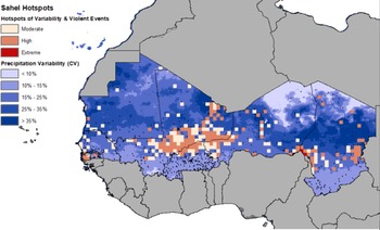
Using data from the Armed Conflict Location & Event Data (ACLED) project dataset, we developed an analysis to assess where the occurrence of violent events corresponded to areas of high climate variability. The basic premise of this analysis was to help understand whether climate variability could be a factor in precipitating violence due to the secondary effects of climate variability on food systems (e.g. lower agricultural productivity, unstable food supply, reduced accessibility to markets). Climate variability is measured using the long-term (1981–2015) CV of annual rainfall, computed as the ratio between the standard deviation and the mean of the long-term rainfall. The occurrence of violent events is assessed by counting the number of fatalities falling in each cell of a gridded surface at approximately 55 x 55 km resolution (0.5 degrees). Areas where high numbers of fatal events coincide with high levels of climate variability are then coded as “moderate”, “high” and “extreme” based on geometrical intervals calculated by minimizing the sum of the squares between each of the three classes.
State governance mechanisms were always low or minimal (in modern state terms), partly due to environmental and geographical challenges, partly due to colonization. However, progressing climate variability and change are threat multipliers that can further exacerbate drivers and mechanisms of conflict throughout the food systems. The majority of the hotspot areas fall within a band of medium levels of precipitation variability (15–25%) along the southern boundary of the Sahel (Figure 2). This association is particularly prevalent in southern Senegal, central Mali, and continues along the southern border of Niger and traversing south-central Chad. The Mali war (2012–present), the Chadian civil war (2005–2010), Tuareg rebellion in Niger (2007–2009), the Boko Haram insurgency (2009–present) and the Casamance conflict (1982–2014) are amongst the main conflict events in these conflict–climate hotspots. The area around Lake Chad is of particular relevance as the most extreme cluster of fatal violent events and the subject of United Nations censure in 2020. This area is, likewise, an area of high climate variability and is a known centre of drought and other observable impacts of climate change.
Co-occurrence of climate variability and conflict.

While there are violent events occurring throughout the range of observed climatic variation, and the causes of conflict are varied, the concentration of violent events in areas of high climate variability does suggest that climate and conflict are linked. In most Sahelian countries, where conflict arises because of armed clashes between government military forces and insurgent groups, climate has the potential to exacerbate food insecurity, poverty and famine even further. In the Lake Chad area, for instance, the climate conditions compound the challenges of internally displaced peoples and these groups are then more readily targeted by a variety of armed groups. In addition to political or socio-economic marginalization, these conditions also have the potential for negative feedback loops that result in even more conflict, as families are disrupted, and rural youth are drawn in or forcefully recruited into different terrorist and insurgent groups. Building an evidence base to identify the specific actions that increase resilience to climate variability and change and enhance food security and nutrition, and make communities more resilient to conflict, is therefore needed.
Pathways through which climate and conflict relate
Previously we have mentioned the importance of socio-economic and political factors in the outbreaks of conflict where climate hazards can act as threat multipliers. An emerging question is what do the pathways through which climate and conflict relate look like and where should we place the intermediate role of food systems?
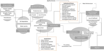
We observe that environmental scarcity is fuelled by climate variability and change and can cause rent-seeking behaviour and competition, creating conflict and violence over scarcer resources.Footnote 43 In addition, many political ecology scholars started stressing the importance of other drivers such as instability, poor governance and other location-specific social and political factors as confounding elements that could explain the resource scarcity–conflict nexus.Footnote 44 Also, food security has been suggested as an important driver connecting climate change to conflict.Footnote 45 The complex relationship is represented in Figure 3, presenting the aforementioned factors in greater detail. In the next paragraphs, we explain in detail how this complexity unravels across the identified drivers with specific examples from the Sahel region.
Pathways showing climate and food system dynamics as drivers of conflict.

In the most recent reviews of the scattered literature on the mechanisms connecting climate change and conflict it appears that there is wide agreement about climate and conflict being linked through economic outcomes and migration.Footnote 46 Scheffran et al.Footnote 47 outlined that climate can indirectly affect the likelihood of conflict outbreaks through multiple channels such as water scarcity, crop failures, human migration and institutional effectiveness. Specifically, in agricultural households, climate variability and extreme weather events are likely to affect incomes through reduced agricultural outputs,Footnote 48 as is displayed in Figure 3. Existing empirical research suggests that adverse climate impacts affecting food and livestock prices in sub-Saharan Africa can lead to low-level political violence, for example, protests and riots, specifically in urban areas where cheap substitutes are absent.Footnote 49 Additionally, climate-induced migration can burden competition over resources such as land, employment, education, health care and social services and possibly cause ethnic tensions.Footnote 50 Conflicts in the Sahel are usually in connection with many different intertwined institutional drivers, among which governance, discrimination against groups with weaker political and economic positions, and ethnic and religious factors all come into play (see Figure 3, “Institutional Drivers” box), with climate change increasingly acting as an amplifier that contributes to trigger violence.Footnote 51 Elite exploitation is another mediating mechanism discussed in studies on climate–conflict links.Footnote 52
In the Sahel, many case studies have investigated communal violence, encompassing farmer–herder (pastoralist) events, sometimes escalating into insurgent activities. Communal conflict is more likely in wetter periods than in drier periods, where increasing water scarcity, and largely pre-existing poverty and ethnic divisions can serve as key drivers.Footnote 53 For example, in South Sudan, “droughts led to increasing crop failure, shrinking availability of pasture, both of which have resulted in forced migration for cattle herders to locations with more abundant resources; however, these places are already occupied and consequently led to violent conflict”.Footnote 54 This trend is exacerbated by cattle-rustling and ethnic tensions, as well as the interaction with persisting social problems, which are outlined in more detail in Figure 3, in the “Social Drivers” box. The vulnerability of herders is seeded in these drivers.
Looking at more insights from the region, for example, in Sudan, commercial farming (in Figure 3, Agribusinesses) displaced peasants and pastoralists. Also there is the Darfur conflict, which is partly driven by ethnic disputes, “with mounted pastoralists (mostly Arab tribes supported by the government) preying on non-Arab refugees displaced from their farming lands by drought, linked to climate change”Footnote 55 as well as due to the development of commercial farming in the Nile basin.Footnote 56 In northern Mali and Niger, Tuareg communities have occupied the zone for a long time and follow a history of rebellions against colonizers and central governments, being an example of political marginalization contributing to onsets of conflicts as well as the potential exacerbating effect that desertification can have.Footnote 57 In another case study in the inland delta of the Niger river in Mali, it was found that the main mechanisms are related to structural factors that could be considered as the main drivers behind local conflicts. The drivers are the dominance of agricultural reform bringing restricted mobility for pastoralists, political negligence and rent seeking, and corruption among officials.Footnote 58 The agricultural mismatch is argued to result from an ongoing process of pastoral marginalization and wider underestimation of pastoral productivity as well as pastoralists’ contribution to the national economy.Footnote 59 An example from Northern Cameroon shows also the effects of farmer and herder conflict and how this can have negative feedback effects due to the conflict.Footnote 60 Such effects are reduced income and negative effects on livelihoods leading to families taking out their children from school as payment becomes difficult. Further costs for court cases to resolve conflict are high, and the lack of financial means can lead to food insecurity and issues if hospital costs need to be paid.Footnote 61 Finally, in Northwest Cameroon, MbihFootnote 62 shows that historical and political–ecological factors from colonial administrations are the main cause of conflict, as well as religious and ethnic difference. In Cameroon, “wealthy livestock owners have been involved in communal land grabbing and the irrational use of the commons while taking advantage of the complicated and weak land tenure policy”.Footnote 63
In summary, functioning food systems and food security in the region are critical intermediate components through which the exacerbating effect of climate variability and change on conflict can be alleviated, as well as being complemented by reducing poverty and providing resilience to weak institutions. We suggest that the impact of climate mitigation and adaptation efforts complementing interventions strengthening food systems and their climate resilience can have a compounding effect on the ultimate degree of success of peacebuilding efforts and should therefore be embedded in current security operations to prevent conflicts and contribute to peace.
Results Chapter 2: How do existing peace indicators capture climate security for the Sahel?
Many measures and indices of peace and security have been developed throughout the years. The Global Peace Index (GPI), by the Institute for Economics & Peace (IEP), for instance, is an annual measure of negative peace (NP) – the absence of violence – ranking 163 states and territories according to their peacefulness levels. States are evaluated using both quantitative and qualitative methods covering three criteria (ongoing domestic and international conflict, societal safety and security, and militarization) and twenty-three indicators.Footnote 64
The IEP also produces a measure of positive peace (PP), the Positive Peace Index (PPI).Footnote 65 The PPI is composed of eight main pillars: well-functioning government, sound business environment, acceptance of the rights of others, free flow of information, high levels of human capital, low level of corruption and equitable redistribution of resources. The IEP defines PP as a proxy for the country-level socio-economic resilience, or in other words the buffer against which instabilities and risks are mitigated and neutralized for a sustained peaceful society.
Positive peace, defined as “the attitudes, institutions & structures that create and sustain peaceful societies”Footnote 66 and NP, defined as “the absence of violence or fear of violence”,Footnote 67 are assumed to be complementary and mutually reinforcing dynamics. The most peaceful countries are bound to have high PP, as good governance, social and institutional infrastructure, and systems can reduce the chance of the insurgence of tensions and insecurities. On the other hand, NP contributes to the stability of national institutions and systems that contributes to PP. Therefore, there exists a positive correlation between the two measures of peace. Furthermore, the IEP argues that PP and NP in combination lead to sustainable peace, after which a state is highly unlikely to fall into future conflicts.
The IEP has only recently started recognizing the growing threat of environmental change to security. The 2019 GPI report notes that although long-term quantitative data on the interactions between climate change and peace are lacking, “climate change can indirectly increase the likelihood of violent conflict through its impacts on resource availability, livelihood, security and migration”.Footnote 68 The report also notes that “in 2017, 61.5 percent of total displacements were due to climate-related disasters, while 38.5 percent were caused by armed conflict”,Footnote 69 asserting that climate-induced migration is likely to become a source of both internal and international conflict, as internal migration may lead to competition for resources and tension between neighbouring communities, and the host states of international migrants may not have the institutions and mechanisms in place to receive large numbers of climate migrants.Footnote 70
In 2020, the IEP also launched an Ecological Threat Register, which estimates the likelihood of the occurrence of ecological risks for 157 independent states and territories until 2050. These threats include population growth, water stress, food insecurity and specific climate hazards. In their inaugural report, the IEP shows that 141 countries will be exposed to at least one ecological threat by 2050 and that more than half of these countries are in sub-Saharan Africa. The report also clearly recognizes that ecological threats and climate change “pose serious challenges to global development and peacefulness”.Footnote 71 Despite the increased acknowledgement of the role that climate can exert on violence, conflicts and insecurity, neither the GPI nor the PPI accurately measures the change, variability and impact of climate or relate these to their NP and PP indicators.Footnote 72
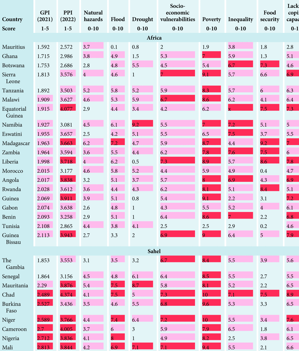
Table 1 shows the ranking of the top twenty most peaceful (GPI ≤ 20) countries in Africa across resilience (PPI), climate risks, socio-economic existing insecurities, and coping capacity to climate impacts. Table 1 shows that thirteen out of the top twenty most peaceful countries in Africa and eight out of nine countries in the Sahel are exposed to medium (red) or high risks (dark red) of natural hazards. The Gambia is the only country in the Sahel with a low risk of natural hazards (white cell). Of these countries, eighteen have medium or high exposure to floods (nine in the Sahel); twelve have medium or high exposure to drought (six in the Sahel). Exposure to floods and droughts is widespread among both groups of countries although higher risks are seen in Sahelian countries. However, the coping capacity of countries both in the Sahel and Africa is not currently strong enough to face those phenomena. A total of nineteen out of the twenty most peaceful countries in Africa and nine out of nine in the Sahel have a medium or low coping capacity, with Mauritius being the only country with a high level of coping capacity. This shows that low levels of climate resilience do not match the high level of exposure to climate hazards even in these countries. The significant exposure to climate risks also does not match the strength of institutions and systems that ought to buffer existing insecurities (PP). Only six out of the twenty most peaceful countries in Africa, as measured by the GPI, have high levels of PP (white cells) while Senegal is the only country with high levels of PP in the Sahel. We can then observe that there is an overall trend in Africa of countries being considerably exposed to climate risks while not having high levels of coping capacity and socio-economic resilience (PP) and this trend is considerably worse in the Sahel.
Indicators of coping capacity, socio-economic resilience and existing climate-vulnerable risks in the twenty most peaceful countries in Africa and in the Sahel

The colouring is based on the specific scale used by the 2021 GPI,Footnote 73 the 2022 PPIFootnote 74 and the 2022 INFORM Risk IndexFootnote 75 to establish low, medium or high levels of peace and risk. Dark red is used for low levels of peace of the GPI (above 2.35) and the PPI (above 3.66); light red for medium levels of peace of the GPI (between 1.9 and 2.35) and the PPI (between 3.18 and 3.66); white for high levels of peace of the GPI (below 1.9) and the PPI (below 3.18). In the rest of the indicators, extracted from the INFORM Risk Index, dark red shows high risk (above 6.66), light red shows medium risk (between 3.33 and 6.66) and white shows low risk (below 3.33).
Table 1 also reports the level of other existing insecurities present in the twenty most peaceful countries in Africa and in the Sahel. The results show that in Africa, eighteen countries experience medium or high levels of socio-economic vulnerabilities, including eighteen countries with medium or high levels of poverty, fourteen with medium or high levels of food insecurity, and eighteen with medium or high levels of inequality. Similarly, in the Sahel, all nine countries have medium or high levels of socio-economic vulnerabilities and high levels of poverty; eight countries have medium or high levels of inequality; and four countries have medium or high levels of food insecurity.
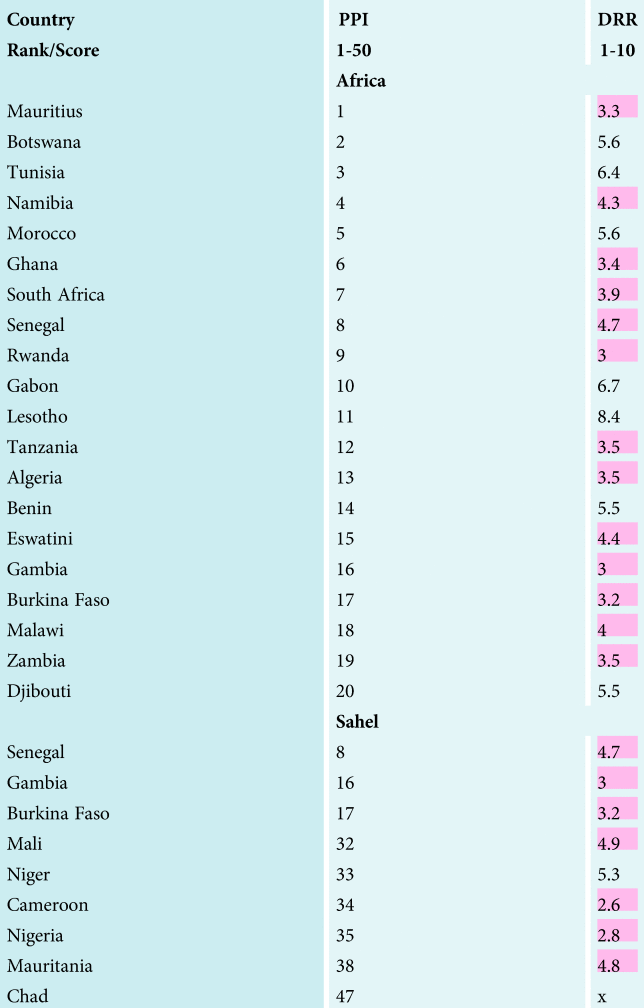
In summary, high exposure to climate impacts, high socio-economic insecurities that are vulnerable to climate impacts, and low preparedness and resilience to climate shocks suggest that even the most peaceful countries are not safe in the context of a climate crisis (see Table 2 for the level of natural hazard preparedness of the most resilient countries). This is because climate can exacerbate existing risks and insecurities that can lead to the insurgence of tensions, fragility and conflicts. The speed and likelihood of the occurrence of insecurities and conflicts might depend on how big climate impacts are and on how strong the multiplier effect of climate on other insecurities is. Nonetheless, the most common measures of peace and security do not adequately address the role of the climate crisis. To ensure that policy makers are correctly informed on the widespread risks, it is, therefore, imperative to thoroughly review the way peace and security are measured. More explicit understanding of the level of exposure to climate hazards and their impact on existing insecurities must become an integral part of the measurement of peace and security.
Level of natural hazard preparedness of the most resilient countries as ranked by the 2019 PPI

The values in red are lower than the average. The ranking scores are estimated by the authors using the 2019 PPIFootnote 76 and the 2021 INFORM risk data (disaster risk reduction; DRR).Footnote 77
Results Chapter 3: The importance of investing in climate adaptation of food systems to ensure peace and security
Agricultural R&D is central for sustainable food systems and can be a critical driver for peace and security. An effective R&D system allows: (1) the development and piloting of targeted innovations that address existing needs and constraints; (2) the deployment of such innovations at the scale required to contribute to poverty alleviation, food security and overall economic growth. Based on a compilation of 376 individual estimates of internal rates of return (IRR –the annual rate of growth for an investment) for agricultural R&D, Pardey et al.Footnote 78 report a median IRR of 35% (standard deviation = 38.5%) across sub-Saharan African countries. Sahelian countries (range 30–100%), and especially Chad and Burkina Faso (with IRR > 60%), show the largest returns. For CGIAR research, a recent analysis reported a mean cost–benefit ratio of 1:12, compared to an average of 1:10 of non-CGIAR research.Footnote 79 These figures provide a clear picture of the substantial returns on investment for agricultural R&D. The problem is that overall agricultural R&D investment is very low in sub-Saharan Africa (3.9% of the global total).Footnote 80 Furthermore, the IRR or investment return figures do not specifically separate R&D for climate change adaptation, nor do they provide an indication of the social contribution to peacebuilding and security. Agricultural R&D activities vary widely by type (i.e. applied research, basic research, extension, or combinations of these) and also in terms of region and farming system targets. Investments in agricultural R&D focused on climate adaptation can target the development of climate-resilient varieties,Footnote 81 the implementation of climate-smart agricultural practices,Footnote 82 information services for better agronomy and climate risk management,Footnote 83 insurance to transfer risksFootnote 84 and financing options.Footnote 85
This section reviews specific R&D activities across the Sahel and discusses potential ways in which they have contributed to food security and peacebuilding. The list of examples is not exhaustive but showcases some of the main R&D activities currently implemented.
Climate-sensitive crop improvement
Crop-improvement networks have played an important role in increasing crop productivity levels and reducing food insecurity and poverty.Footnote 86 Garbero et al.Footnote 87 assessed the overall impact of CGIAR improved seeds interventions between 2007 and 2015 and found that improved varieties reduced poverty by 4% (although this finding is not statistically significant), increased income by 35% and increased expenditure by 14% in adopting households in rural areas.
Climate-sensitive crop improvement, also referred to as climate-smart breeding, seeks to develop novel crop varieties that are adapted to the set of stresses that are expected in the future.Footnote 88 Model-based analyses suggest that productivity gains from climate-smart breeding can be in the range of 10–50% under climate change.Footnote 89 Many efforts are already ongoing across sub-Saharan Africa to develop and promote the adoption of climate-resilient varieties, especially targeting drought, heat, flooding and salinity tolerance. Despite adoption constraints, these varieties are already being adopted by small-scale producers.Footnote 90
An evaluation of the potential impacts of the Drought Tolerant Maize for Africa (DTMA) project (a CGIAR-led breeding effort in thirteen countries of eastern, southern and western Africa) estimates that economic and poverty reduction benefits from full adoption of drought-tolerant maize varieties are in the range of US$ 0.53 to 0.88 billion (2007–2016).Footnote 91 In Mali, these gains are estimated at about US$ 10 million, and can lead to an overall increase in maize production of 7%. Across sub-Saharan Africa, various studies report widespread adoption and benefits from climate-resilient wheat,Footnote 92 small cereals,Footnote 93 as well as rice and other crops.Footnote 94 Ouédraogo et al. show that since 2011 to now, the adoption of improved variety increased from 32.9% to 95.6% in the Mali climate-smart villages.Footnote 95
While the benefits from climate-resilient varieties are already substantial, the potential of these varieties to transform African food production systems is far from being realized. Adoption levels remain moderate at best, and systems for delivery of improved seeds are largely underdevelopedFootnote 96 and unprepared for climate change.Footnote 97 Acevedo et al.Footnote 98 report that access to extension, experience and skills, education, farm inputs, financial instruments and climate information constitute major obstacles in the way of achieving large-scale benefits from climate-resilient seeds. Furthermore, the potential of improved varieties to contribute to poverty reduction and food security is fully realized when improved varieties are part of a broad climate-resilience strategy that includes other agricultural practices and technologies.
Climate-sensitive crop improvement helps adaptation to recurrent, pervasive and co-occurring climate variability and hazards (e.g. seasonal drought and heat stress) that can lead to recurring conflict among people whose farming systems are rainfed and therefore exposed to these hazards.Footnote 99 As water availability diminishes due to lack of rain and hot weather, intercommunal conflict over access to wells and riverbeds becomes more likely.Footnote 100
Climate-smart agricultural practices
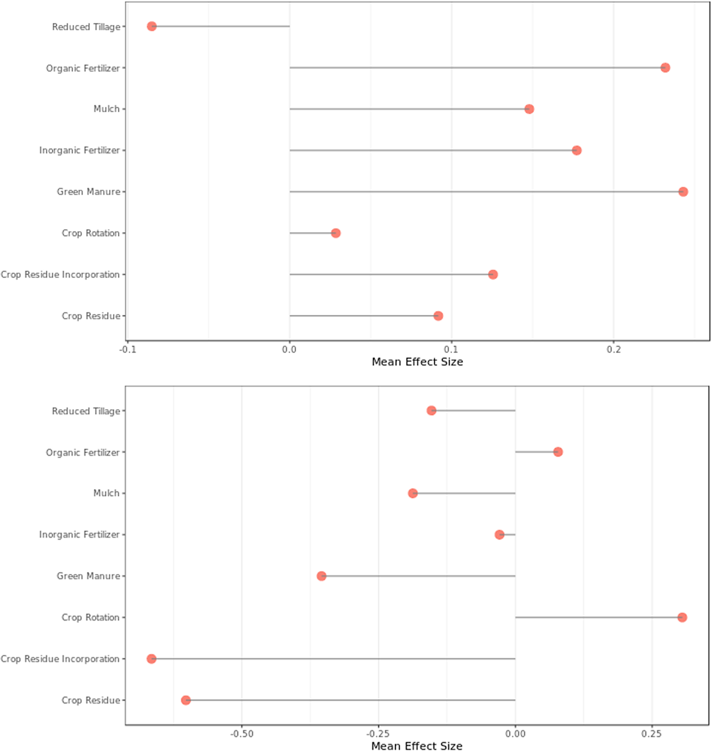
Climate-smart agriculture (CSA) seeks to sustainably increase agricultural productivity, enhance resilience, and, where possible, also reduce greenhouse gas (GHG) emissions.Footnote 101 Agricultural practices that have positive effects on yield, resilience and GHG emissions exist and evidence of their benefits has been documented for some agro-ecologies and cropping systems.Footnote 102 Figure 4 shows the mean effect size for eight practices across five of the six countries analysed here (no data for Chad were found) as reported by a meta-analysis of published literature.Footnote 103 Across West Africa, the CGIAR has been using “climate-smart villages” to test many of these options as part of an ongoing global effort to bring CSA to scale.Footnote 104
Mean effect of different practices on productivity (top) and resilience (bottom). Taken from Evidence for Resilient Agriculture (ERA), available at: https://era.ccafs.cgiar.org/.

Implementing CSA at scale requires a multi-disciplinary approach that goes beyond the biophysical piloting of options in specific agro-ecologies, and seeks to understand how these options can be embedded in a given socio-economic context and how science–policy interfacing (see the “Enabling environment and the science policy interface” section) can help bring them to scale.Footnote 105 A starting point in this process is the identification of the trade-offs and synergies of CSA practices across space and time,Footnote 106 followed by participatory processes that help identify what options have the largest potential (based on their biophysical performance and farmer adoption). Partey et al.Footnote 107 show that agroforestry options (i.e. farmer-managed natural tree regeneration activities), as well as soil and water conservation technologies (i.e. zaï pits, half-moon, tie/contour ridges, conservation agriculture), are the most promising CSA practices for West African farmers due to their substantial potential to increase productivity and help manage climate risk. Ouédraogo et al.Footnote 108 indicate that adoption of CSA technologies is greater across West Africa if it is accompanied by capacity development and education programmes. These authors highlight the crucial role of community-, national- and regional-level institutions in creating the enabling environment and securing the necessary financing to scale CSA technologies.
Rapid population growth in the Sahel means that total food production needs to increase to reduce the risk of food insecurity crises. Sustainably increasing food production under climate stress is a major challenge in this very harsh environment. At the same time, food security is an important driver connecting climate to conflict (see the “Pathways through which climate and conflict relate” section). Empirical research suggests that adverse climate impacts affecting food and livestock prices in sub-Saharan Africa can lead to low-level political violence (e.g. protests and riots) in urban areas where cheap substitutes are absent.Footnote 109 CSA practices and technologies are one piece in the puzzle to prevent conflicts, being natural capital that contributes to food security and thus indirectly to peace and stability.
Climate information services
Information services to support farmer decision-making in the face of climate variability offer significant potential to build resilience and enhance food security and nutrition.Footnote 110 These services, mostly known as climate information services (CIS) or climate services more generally, are defined as the systematic provision of climate information in support of sector decision-making. By design, climate services arise from a systematic process of co-production, translation, transfer and use of tailored decision support information.Footnote 111 User-tailored CIS have been shown to support up to a 66% increase in yield and corresponding gains in income.Footnote 112 Since insufficient availability of and access to climate information can constitute a barrier for the adoption of certain practices and technologies,Footnote 113 CIS can also help unlock climate adaptation at scale. In fact, CIS can be extended to include advice on best agronomic practice, pest and disease early warnings, and market information related to the current or upcoming season.Footnote 114
To assess the potential for CIS implementation across the Sahel, we developed an analysis of CIS hotspots. We define a hotspot as an area in which high seasonal forecast skill co-occurs with high climate variability. Climate variability is defined using the CV of annual rainfall (standard deviation normalized by the mean), whereas forecast skill is defined using the precipitation tercile classification skill at 0.5-month lead time as reported by the International Research Institute for Climate and Society (IRI) seasonal climate forecast verifications.Footnote 115 In the areas of the Sahel adequately covered by the available data, approximately half of the analysed area has either high potential or can be considered implementation-ready for CIS. Areas labelled as having ‘potential’ would require some level of investment in better seasonal prediction systems and climate data infrastructure to support CIS achieving their full potential (see Figure 5).
Priority areas for investment in climate information services (CIS). Grey areas are either outside of the Sahel or have no data.

As mentioned above, CIS can be tailored in many different context-specific ways and be disseminated using different mechanisms including text messaging, user groups, web platforms, and more. The basic objective is always the same, i.e. to inform farming decisions either ahead, during, or at the end of the season. In West Africa, one of the most important uses of CIS lies in helping farmers decide what to crop during the sole rainy season, when to prepare their field and sow their crops, as this reduces the risk of crop failure.Footnote 116 It is estimated that upwards of ten million farmers in West Africa currently have access to CIS through radio and short message service (SMS),Footnote 117 and new projects are bringing many more farmers onboard with every season.
Climate services exemplify the need for adaptive management of development research. The CGIAR's Research Program on Climate Change, Agriculture and Food Security (CCAFS), for example, collaborated with the Senegalese National Meteorological Agency (ANACIM) to develop CIS that are relevant to farmers on a broad scale. As of August 2015, seasonal forecasts are transmitted nationwide through 102 rural community radio stations and SMS (the best means available for the region), potentially reaching 7.4 million rural people across Senegal. Climate information in Senegal is now considered an agricultural input just like seeds, fertilizers and equipment, which are at the basis of production.Footnote 118 An impact assessment study revealed that the use of CIS in Senegal led to 10–25% increases in household income.Footnote 119
Small-scale farmers who do not receive adequate information and capacity-building are often caught unprepared when required to respond to climate variability. This leads to cycles of low output resulting in low income. The income disparity and inequality between local farmers and other citizens can fuel social envy and can be potential sources of conflict.Footnote 120 Climate services are a means to manage risk, they can minimize losses and damages caused by shocks such as floods, droughts or storms, and reduce the need for humanitarian assistance in their aftermath. Through reducing the recovery time and the number of food-insecure people, these strategies can reduce the risk of community destabilization, riots and protests.
Crop insurance
Helping farmers make better choices by de-risking their farming activities has proven successful across Africa. In East Africa for example (Kenya, Rwanda and Tanzania), the Agriculture and Climate Risk Enterprise (ACRE) recently scaled to reach nearly 200,000 farmers, bundling index insurance with agricultural credit and farm inputs.Footnote 121 ACRE has built on strong partnerships with regional initiatives such as M-PESA mobile banking. In Ethiopia and Senegal, the R4 Rural Resilience Initiative has scaled unsubsidized index insurance to over 20,000 poor smallholder farmers who were previously considered uninsurable, using insurance as an integral part of a comprehensive risk management portfolio.Footnote 122 Also, the Index-Based Livestock Insurance (IBLI) project in Kenya and Ethiopia demonstrates innovative approaches to insuring poor nomadic pastoralists in challenging circumstances.Footnote 123 The examples show that insurance is deployed most effectively bundled with loans, credits, agricultural inputs such as fertilizer and climate-resilient seeds, and in combination with CIS providing information on what to plant, where, when and how.
Insurance products help transfer climate risk from low-likelihood high-impact events from the farmer toward insurers and re-insurers, at a reasonable cost for the farmer. Climate variability and extreme drought events that lead to crop failure or livestock death accelerate competition over the same scarce resources and increase, for example, territorial tensions over pasture and surface and underground water resources.Footnote 124 This creates a fruitful environment for extremist groups like Al-Shabab to recruit fighters by offering cash and other benefits to individuals trapped in poverty and lacking alternative sources of livelihoods.Footnote 125 Insurance can prevent climate shocks from leading to loss of crop and livestock, assets, income, price volatility, food insecurity and thus leading to grievances and instabilities.
Sustainable finance
The Sustainable Development Goals (SDGs), resulting from the 2015 Paris Agreement, define ambitious goals to end poverty and hunger and provide a strategic framework for a transition towards peace and prosperity by 2030. Five years after their adoption, funding resources are falling remarkably short – with an enormous gap of US$ 2.5 trillion annually.Footnote 126 Realizing these shortfalls, the international community has been increasingly engaging with the private sector to mobilize and drive investments. Indeed, if we were to align just a proportion of the capital invested daily in capital markets, including resources from institutional investors, retail investors, etc., this would catalyse significant progress towards achieving the SDGs. It is worth highlighting that of the US$ 153.9 billion mobilized in blended private finance, approximately US$ 9.3 billion went to least developed countries.Footnote 127 To fill this private financing gap, recent initiatives, such as the International Committee of the Red Cross's (ICRC) Humanitarian Impact Bond, have encouraged the private sector to enter these complex environments. Impact Bonds are financial instruments (results-based contracts) in which private investors provide pre-financing for public projects that deliver social and environmental outcomes. Governments, development or other philanthropic funders pay back investors their principal plus a return if, and only if, these projects succeed in delivering social and environmental outcomes.
Engaging with private finance to co-address cross-cutting environmental, humanitarian and development objectives poses certain challenges that require institutional realignment. One challenge is balancing the need to generate cash flows from the private sector alongside the goal of reducing poverty in fragile contexts, where cash flows may not yet be generated. Private investors may not be inclined to take high risks in these environments, whereas public actors do not face this challenge, as they expect no profit return from using public funds. In addition, the sheer complexity in addressing environmental, social and governance factors requires establishing broad collaboration frameworks with appropriate indicators to track long-term progress.
It is paramount that humanitarian, development and peacebuilding objectives and incentives are aligned, and investments are made to mutually reinforce each other. There are plenty of emerging sustainable finance schemes from the agricultural development sector that currently do not address peace objectives systematically. For example, the West African Initiative for Climate-Smart Agriculture (WAICSA) provides financial and technical support to incentivize the adoption of CSA and increase local financial institutions’ capacity for climate-smart lending.
Enabling environment and the science–policy interface
Science–policy engagement efforts are crucial to ensure that scientific findings from agricultural research for development inform actions of governments, the private sector, non-governmental organizations (NGOs) and international development partners, accelerating progress toward upper-level goals.Footnote 128 A few examples where this is being done from across the Sahel include: the New Partnership for Africa's Development (NEPAD) agency that is leading the implementation of the African Union–NEPAD Agriculture Climate Change Programme, which aims to have twenty-five million farm households practising CSA by 2025;Footnote 129 the Africa CSA Alliance, a partnership between the NEPAD agency and five international NGOs (CARE, Catholic Relief Services, Concern, Oxfam and World Vision); and the Comprehensive Africa Agriculture Development Programme (CAADP) that aims to reach at least six million farm households with CSA reaching twenty-five million farm households.Footnote 130 In West Africa, included is the West African CSA Alliance (WACSAA) and the regional initiative called “The Promotion of Smart-Agriculture towards Climate Change and Agro-ecology transition” that aims to ensure adoption of CSA practices by twenty-five million households by 2025.
The above regional efforts are complemented by national and local efforts. A successful example at national level in Ghana, Mali and Senegal is the CCAFS West Africa multi-stakeholder national science–policy dialogue platforms on CSA, that use scientific evidence to create awareness of climate change impacts on agriculture and advocate for the mainstreaming of climate change and CSA into agricultural development plans.Footnote 131 Results show that these platforms are an innovative approach to effectively engage decision-makers and sustainably mainstream climate change into development plans. In Senegal, for example, the national platform engaged with policymakers through targeted knowledge sharing workshops, which led to the inclusion of the scientific evidence into the agricultural component of the presidential plan for an emerging Senegal by 2035 (PSE).
However, the above-mentioned science–policy enabling environment has not yet addressed peace and security aspects explicitly, which is a missed opportunity and of crucial importance for food systems to contribute to lasting peace.
Contribution of R&D food system programming to peace and security in the Sahel
From the discussion above we draw that food security and resilience of local food systems can potentially serve to address the complexities dealing with the cycle of conflict, poverty and climate security in the region. We suggest that moving away from a reactive scheme to a more preventive approach should include the establishment of sustainable food systems, while addressing the root causes of conflict.
While the value of R&D across sub-Saharan countries is documented widely, data on social returns of R&D related to climate programming specifically are much scarcer. A study of IFAD's Agricultural Smallholder Adaptation Programme (ASAP) concludes that the social return on investment (SROI) ratios range from 1.26:1 to 4.66:1 for four private sector-leveraged country investments selected out of a portfolio of thirty-nine.Footnote 132 The authors have not found data on the IRR or SROI of R&D in agricultural and food systems for peace and security, which is a field that needs to be addressed.
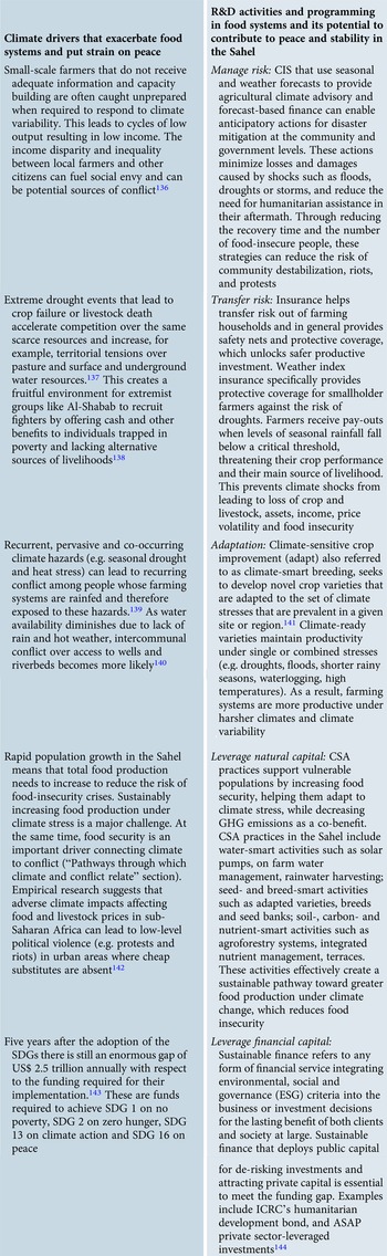
The set of agricultural R&D interventions in food systems described above demonstrably has potential for poverty reduction and food security.Footnote 133 Their contribution to peace and security is, however, less clear. As shown in the “Climate and conflict hotspots in the Sahel” section, conflict occurs in climate hotspots. In many of the hotspots there are ongoing interventions to enhance resilience and food security. A quick perusal of the theories of change and scenarios considered for the development of these activities and projects suggests that peace and security have not been considered as an outcome from the outsetFootnote 134 but have the potential to contribute to lasting peace.Footnote 135 In Table 3 we therefore summarize the potential contributions of these R&D agricultural and food systems activities and programming for peace and security. R&D activities contribute through specific mechanisms towards peace and security such as managing risk, transferring risk, adapting, and leveraging natural capital and financial capital.
Overview of climate and drivers that exacerbate food systems and its respective R&D activities that have the potential to buffer those drivers and contribute to peace and stability

Conclusion
It is by now well acknowledged that the current literature does not display an exact consensus on the interface of climate and conflict, with some even doubting its fundamental validity. Yet, there is a generally accepted view that a relationship between climate and conflict is observable, despite the fact that the exact mapping of conflict pathways remains elusive. Complexity, systemic, albeit highly contextual, lenses are needed to capture the whole set of direct and indirect channels and feedback loops across different existing risks and insecurities and to accurately represent the highly intertwined relationships across the entire climate–security nexus.
In this paper we have embraced this complexity and demonstrate for the Sahel that (i) climate hazards are frequent and exposure to climate variability is high across the Sahel, (ii) hotspots of high climate variability and conflict exist, and (iii) impact pathways by which climate exacerbates food systems drivers that can lead to conflicts are documented in the literature. While these three findings suggest clear links between conflict and climate, we find that (iv) current peace indices do not include climate and food systems indicators and therefore provide an uncomplete picture, and (v) food systems programming for climate adaptation has so far not explicitly considered peace and security outcomes. Despite this, R&D for agricultural and food systems have the potential to contribute to peace and security through managing risk, transferring risk, adaptation, and leveraging natural and financial capital. Future studies are needed that evaluate agricultural and food system R&D returns on investment specifically for peace and security outcomes. Furthermore, we propose that food systems programming that truly tackles the climate crisis should take more explicit account of peace and security outcomes in conflict-affected areas.