Introduction
Soil is one of the most important constituents of an ecosystem, playing a crucial role in many environmental reactions and processes. The origin and properties of natural soils are related to soil formation factors such as local geology, relief, climate, hydrology, vegetation, fauna and time (Brady & Weil, Reference Brady and Weil2004). However, the soils of urban areas are formed additionally in close relation to human activity, which leads to soil mixing, sealing, compaction and degradation (Lorenz & Lal, Reference Lorenz and Lal2009; Mao, Sang, Liu, & Jia, Reference Mao, Sang, Liu and Jia2014). Some physical properties, and especially chemical properties, of soils are very sensitive to human activity and may be used as indicators of urban environment quality (Mao et al., Reference Mao, Sang, Liu and Jia2014).
Studies on soil properties and geochemistry in urban areas are common at many sites in Europe (for example, Acosta, Faz, & Martinez-Martinez, Reference Acosta, Faz and Martinez-Martinez2010; Andersson, Ottesen, & Langedal, Reference Andersson, Ottesen and Langedal2010; Biasioli et al., Reference Biasioli, Grčman, Krajl, Madrid, Diaz-Barrientos and Ajmone-Marsan2007; Birke & Rauch Reference Birke and Rauch2000; Charlesworth, Everett, McCarthy, Ordonez, & De Miguell, Reference Charlesworth, Everett, McCarthy, Ordonez and De Miguell2003; Flem, Eggen, Torgersen, Kongsvik, & Ottesen, Reference Flem, Eggen, Torgersen, Kongsvik and Ottesen2018; Guney, Onay, & Copty, Reference Guney, Onay and Copty2010; Imperato et al., Reference Imperato, Adamo, Naimoa, Arienzo, Stanzione and Violante2003; Manta, Angelone, Bellance, Neri, & Sprovieri, Reference Manta, Angelone, Bellanca, Neri and Sprovieri2002; Massas, Ehaliotis, Kalivas, & Panagopoulou, Reference Massas, Ehaliotis, Kalivas and Panagopoulou2010; Mihailović et al., Reference Mihailović, Budinski-Petković, Popov, Ninkov, Vasin, Ralević and Vučinić Vasić2015; Sollito, Romic, Castrignano, Romic, & Bakic, Reference Sollito, Romic, Castrignano, Romic and Bakic2010) and in other continents around the world (for example, Chen, Xia, Zhao, & Zhang, Reference Chen, Xia, Zhao and Zhang2010; Gong et al., Reference Gong, Wu, Bi, Ren, Wang, Ma and Li2010; Lee, Li, Shi, Cheung, & Thornton, Reference Lee, Li, Shi, Cheung and Thornton2006; Luo, Yu, Zhu, & Li, Reference Luo, Yu, Zhu and Li2012; Mao et al., Reference Mao, Sang, Liu and Jia2014; Morton-Bermea et al., Reference Morton-Bermea, HernandeZ-Alvarez, Gonzalez-Hernandez, Romero, Lozano and Beramendi-Orosco2009; Rodriguez-Salazar, Morton-Bermea, Hernandez-Alvarez, Lozano, & Tapia-Cruz, Reference Rodriguez-Salazar, Morton-Bermea, Hernandez-Alvarez, Lozano and Tapia-Cruz2011). Most of these studies focus on the concentration of trace elements and other pollutants (for example, polycyclic aromatic hydrocarbons) in the topsoil horizons, which may negatively affect human health and wellbeing. However, there is a complete lack of published data concerning the physical and chemical properties of the soil cover occurring in urban areas located in the high Arctic such as Longyearbyen, which was found about 100 years ago by the coal miners (for example, Askaer, Schmidt, Elberling, Asmund, & Jónsdóttir, Reference Askaer, Schmidt, Elberling, Asmund and Jónsdóttir2008; Ćmiel & Fabiańska Reference Ćmiel and Fabiańska2004; Lewińska-Preis, Fabiańska, Ćmiel, & Kita, Reference Lewińska-Preis, Fabiańska, Ćmiel and Kita2009).
Similarly, soil studies in Spitsbergen, which is the largest island of the Svalbard archipelago, are also relatively numerous (for example, Dziadowiec, Gonet, & Plichta, Reference Dziadowiec, Gonet and Plichta1994; Etzelmüller & Sollid, Reference Etzelmüller and Sollid1991; Kabała & Zapart, Reference Kabała and Zapart2009, Reference Kabala and Zapart2012; Klimowicz & Uziak, Reference Klimowicz and Uziak1996a,b; Klimowicz, Melke, & Uziak, Reference Klimowicz, Melke and Uziak1997; Madan, Deacon, & Robinson, Reference Madan, Deacon and Robinson2007; Mann, Sletten, & Ugolini, Reference Mann, Sletten and Ugolini1986; Melke & Chodorowski, Reference Melke and Chodorowski2006; Melke & Uziak, Reference Melke and Uziak1989; Migała, Wojtuń, Szymański, & Muskała, Reference Migała, Wojtuń, Szymański and Muskała2014; Szymański, Skiba, & Wojtuń, 2013; Szymański, Skiba, Wojtuń, & Drewnik, Reference Szymański, Skiba, Wojtuń and Drewnik2015; Szymański, Wojtuń, Stolarczyk, Siwek, & Waścińska, Reference Szymański, Wojtuń, Stolarczyk, Siwek and Waścińska2016b; Ziółek & Melke, Reference Ziółek and Melke2014), however such studies are very rarely focused on the human settlements (Longyearbyen, Barentsburg, Ny-Ålesund, Pyramiden, Sveagruva) present on this island (Gulińska et al., Reference Gulińska, Rachlewicz, Szczuciński, Barałkiewicz, Kózka, Bulska and Burzyk2003).
Thus, the main aims of this study were: (1) to determine the texture, chemical properties and mineralogy of the topsoil horizons of urban soils occurring in the Longyearbyen area (Spitsbergen, Norway); and (2) to determine and explain their spatial distribution within the area of Longyearbyen.
Materials and methods
Study area
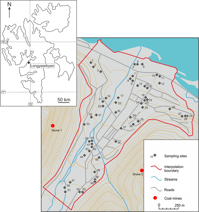
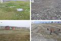
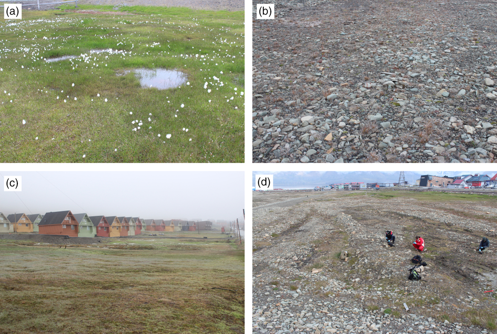
The present study was carried out in the Longyearbyen area, which is the capital city of the Svalbard archipelago, and is the northernmost (78°13′N, 15°33′E) permanently inhabited city in the world. Longyearbyen is located at the mouth of the Longyeardalen in the central part of Spitsbergen (Fig. 1). This part of Spitsbergen was formed of sedimentary rocks of Permian to Eocene age (Dallman, Kjærnet, & Nøttvedt, Reference Dallman, Kjærnet and Nøttvedt2001). The bedrock of the Spitsbergen area consists of sedimentary rocks such as sandstone, siltstone and shale belonging to the Carolinefjellet Formation of Cretaceous age. In addition, the mountains surrounding the Longyeardalen are formed of flat-lying sedimentary rocks such as sandstone and shale of Paleocene age containing coal seams (Firkanten Formation); shale, mudstone and siltstone of late Paleocene age (Basilika Formation); and sandstone of late Paleocene-early Eocene age (Grumantbyen and Hollendardalen formations). Glacifluvial deposits of Holocene age along the Longyearelva are present. The study area lies across an almost flat floor of the Longyeardalen featuring locally occurring small frost mounds and cryogenic landforms such as patterned ground (Fig. 2). The Longyeardalen is limited from the west and the east by the steep slopes of Platåberget Mt., Sukkertoppen Mt. and Gruvefjellet Mt. The lower parts of the slopes are covered with large talus cones. The study area is characterised by a cold and dry climate with a mean annual air temperature (MAAT) of −6°C for the period 1912–2010 (Christiansen, Reference Christiansen2005; Eckerstorfer & Christiansen, Reference Eckerstorfer and Christiansen2011; Hanssen-Bauer, Kristensen, & Steffensen, Reference Hanssen-Bauer, Kristensen and Steffensen1990; Watanabe, Matsuoka, Christiansen, & Cable, Reference Watanabe, Matsuoka, Christiansen and Cable2016). However, the MAAT has increased 4°C for the last few years (Førland et al., Reference Førland, Benestad, Flatøy, Hanssen-Bauer, Haugen, Isaksen, Sorteberg and Ådlandsvik2009). The mean annual precipitation in the period 1961–1990 was 190 mm. Precipitation occurs mainly as snow during the winter months (Beumer, Varpe, & Hansen, Reference Beumer, Varpe and Hansen2017; Christiansen, Reference Christiansen2005; Watanabe et al. Reference Watanabe, Matsuoka, Christiansen and Cable2016). Longyearbyen is located in the middle Arctic tundra zone. Plant community types vary with microrelief and hydrology of the terrain. Heath community including Cassiope tetragona and Dryas octopetala are usually found in the more sheltered parts of mounds and ridges, whereas heath community including Saxifraga oppositifolia, Salix polaris, Luzula confusa and numerous moss species covers some open, flat parts of the Longyeardalen. Wetland vegetation is represented by moss tundra and Arctic mires. Moss tundra vegetation occurs on lower hillsides and across valley floors, where seeping freshwater is present during the growing season. It is dominated by mosses and vascular plants (for example, Carex subsphatacea, Eriophorum triste, Dupontia psilosantha, Ranunculus hyperboreus). At more moist sites, Arctic mires can be found with thick organic horizon derived from bryophytes (Sphagnum spp., Bryum spp., Paludella squarrosa). Sandy, gravelly and rocky habitats located on river fans are usually sparsely vegetated and dominated by bryophytes and lichens. Well-developed, rich in species bird-cliff vegetation is found on steep slopes and cliffs (Johansen & Tømmervik, Reference Johansen and Tømmervik2014; Johansen, Tømmervik, & Karlsen, Reference Johansen, Tømmervik and Karlsen2012; Prestø, Lüth, & Hassel, Reference Prestø, Lüth and Hassel2014).
Location of the study area and sampling sites.

Vegetation cover in the eastern part of Longyearbyen (A, C) and along the Longyearelva (B, D).
Field and laboratory methods
A field study was carried out in July 2016. The soil samples (about 1 kg in weight) from topsoil (uppermost 10 cm) were collected from 53 sites in the Longyearbyen area into plastic bags, air dried and transported to a laboratory of Department of Pedology and Soil Geography of Institute of Geography and Spatial Management at the Jagiellonian University in Kraków (Kraków, Poland). All living plant fragments were removed from the samples during the soil samples collection. In the laboratory, the collected soil samples were gently crushed using a wooden roller pin and passed through a 2 mm stainless steel sieve (Fritsch, Idar-Oberstein, Germany). All living roots were removed before soil analysis. All the soil analysis were done on fine earth material (fraction <2 mm). The sand fraction was determined by wet sieving, whereas the content of the silt and clay fractions was determined using a hydrometer method (Gee & Bauder, Reference Gee, Bauder and Klute1986). Soil pH was measured using a multiparameter measuring device (CX 505; Elmetron, Zabrze, Poland) in deionised water using a 1:2.5 ratio (w/v) after 24 h of balancing time (Thomas, Reference Thomas and Sparks1996). Total organic carbon (TOC) and total nitrogen (TN) contents (in triplicate and then averaged) were determined using a 20 mg of soil sample by dry combustion using a Vario Micro Cube CHN elemental analyser (Elementar Analysensysteme GmbH, Langenselbold, Germany). The soil samples used for TOC and TN content analysis were previously ground in a mortar to homogenise the samples. Soil chemical composition (that is, content of Si, Al, Fe, Ca, Mg, K, Na and P) was determined via inductively coupled plasma-emission spectrometry (ICP-ES) after digestion of the samples using lithium metaborate/tetraborate and dilute nitric acid at Bureau Veritas (Vancouver, BC, Canada).
The mineral composition of bulk samples (fraction <2 mm) was determined by the X-ray powder diffraction using a Rigaku MiniFlex600 benchtop diffractometer equipped with a vertical goniometer, 1.25° divergence slit, 2.5° incident- and diffracted-beam Soller slits, 1.25° anti-scatter slit, 0.3 mm receiving slit, graphite diffracted-beam monochromator, scintillation counter and a Cu X-ray lamp operated at 40 kV and 15 mA. Random powder specimens were X-rayed from 2 to 65°2θ at a counting speed of 0.02°/1 s.
The clay fraction (<2 μm) was separated by centrifugation of 100 × g bulk samples (<2 mm), which were previously dispersed in deionised water using an ultrasonic disintegrator. The separation of the clay fraction was done without any chemical pre-treatment to obtain clay minerals in a natural state. Oriented mounts with a surface density of 10 mg/cm2 were prepared from the separated clay fraction by means of a glass slide technique (Środoń, Reference Środoń, Bergaya, Theng and Lagaly2006). The oriented specimens were scanned from 2 to 52°2θ at a counting speed of 0.05°/2 s in air dry state, after heating for 1 h at 550°C, and after solvation with ethylene glycol for 24 h.
X-ray diffraction analyses of the separated clay fraction were conducted using a Philips X’Pert diffractometer equipped with a PW3020 vertical goniometer, 1° divergence slit, 0.2 mm receiving slit, incident- and diffracted-beam Soller slits, 1° anti-scatter slit, graphite diffracted-beam monochromator and Cu X-ray lamp operated at 40 kV and 30 mA.
Interpolation maps of the spatial distribution of the sand, silt and clay fractions, TOC, TN, Si, Al, Fe, Ca, Mg, K, Na and P contents in the topsoils and their C/N ratio as well as pH values were created via the inverse distance weighting deterministic interpolation method with the second power function modifying the distance weights (Lu & Wong, Reference Lu and Wong2008). An ESRI ArcMap environment was used to perform the interpolation calculation with an assumed resolution of 5 m.
Soil data were correlated with each other using Spearman’s rank correlation coefficient (level of significance at p < 0.05). All statistical analyses were done using Statistica 12 software.
Results and discussion
Texture of topsoils
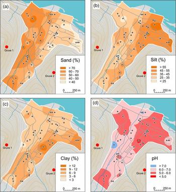
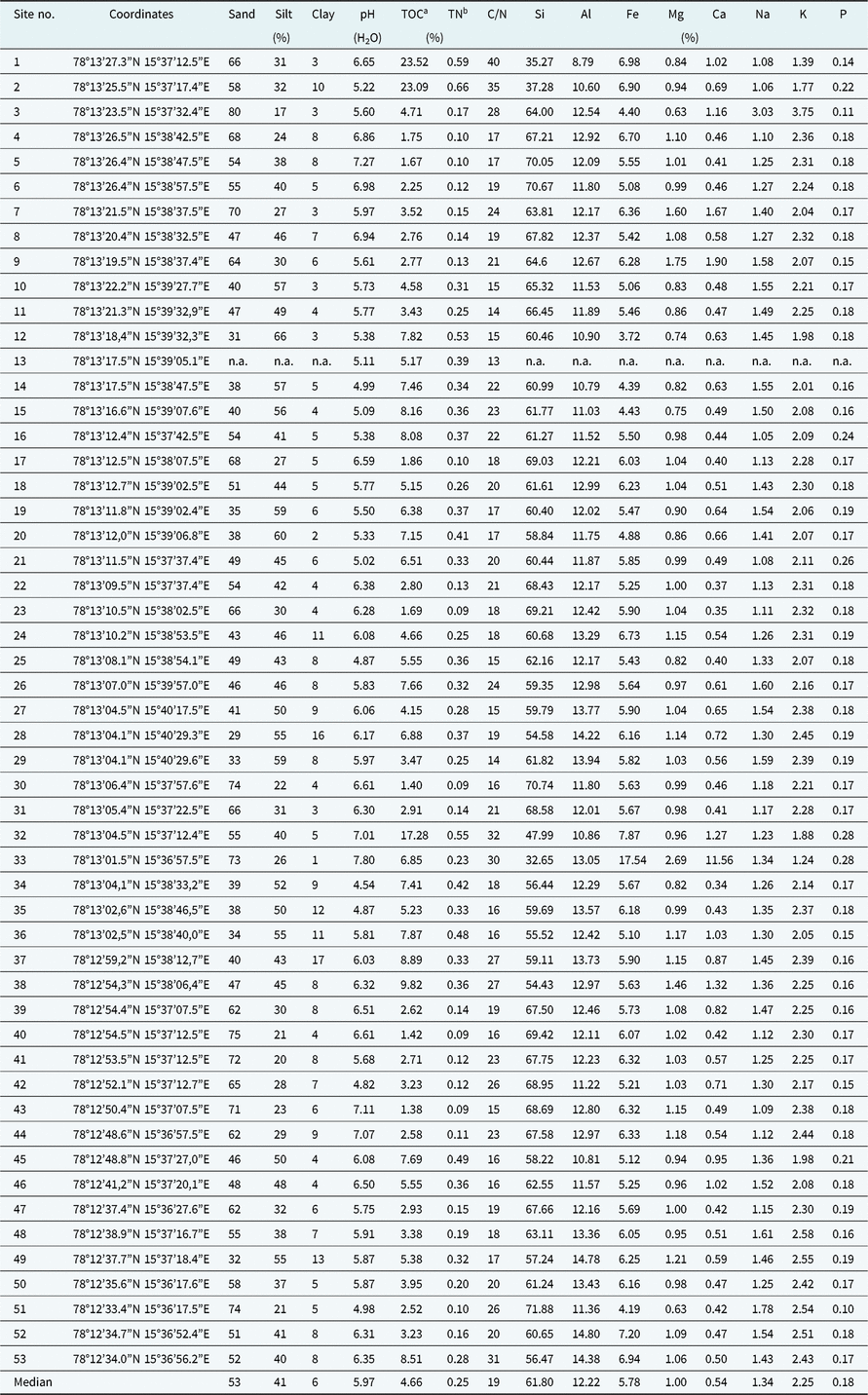
The texture of topsoils in Longyearbyen varies widely from silt loam to sand, with sandy loam and silt loam as the dominant texture. The content of the sand fraction ranges from 29% to 80%, with a median of 53% (Table 1). The content of the silt fraction ranges from 17% to 66%, with a median of 41%, whereas the content of the clay fraction ranges from 1% to 17%, with a median of 6% (Table 1). The spatial distribution of the content of the sand, silt and clay fractions in the topsoils is shown in Figs. 3A–3C, respectively. Generally, the topsoils of the western and northwestern parts of Longyearbyen are characterised by a clearly higher content of the sand fraction (that is, >50%) than soils occurring in the eastern and northeastern parts of the city (Fig. 3A). However, the topsoils of the eastern and northeastern parts of Longyearbyen exhibit a clearly higher content of the silt and clay fractions (that is, >35% and >6%, respectively) than the western and northwestern parts of the city (Figs. 3B–3C).
Content and spatial distribution of sand (A), silt (B) and clay (C) fractions in the topsoils and soil pH (D).

Location and physical and chemical properties of the studied topsoil horizons

Abbreviation: n.a., not analysed.
a Total organic carbon.
b Total nitrogen.
The obtained results of soil texture are related to the geology, which is characterised by a prevalence of sandstone, siltstone, mudstone and shale belonging to the Carolinefjellet, Firkanten, Basilica, Grumantbyen, and Hollendardalen Formations of Cretaceous and Tertiary age (Dallman et al., Reference Dallman, Kjærnet and Nøttvedt2001). The weathering of these rocks produces residues and deposits exhibiting a loamy texture. The clearly higher content of the silt and clay fractions in topsoils of the eastern and northeastern parts of Longyearbyen is most likely related to the prevalence of the southeastern direction of wind and aeolian transport of these fractions from this direction, that is, from the Adventdalen (Bryant, Reference Bryant1982; Christiansen, Reference Christiansen2005; Watanabe et al., Reference Watanabe, Matsuoka, Christiansen and Cable2016). However, most likely lower aeolian accumulation of silt and clay fractions in the western and northwestern parts of the city and the washing out of fine fractions by the Longyearelva along its entire length are responsible for the clearly higher content of the sand fraction in these parts of Longyearbyen.
Chemical properties of topsoils
Soil reaction
Almost all of the studied topsoils are characterised by an acidic or slightly acidic reaction with pH values ranging from 4.54 to 6.94 with a median of 5.97 (Table 1, Fig. 3D). Topsoils exhibiting neutral or slightly alkaline reaction with pH values ranging from 7.01 to 7.80 occur only at some sites, and are associated with the presence of carbonates in the soils of these sites (0.48%-11.34%). The lowest pH values (<6.0) were noted in the northeastern, northwestern and southwestern parts of the city (Fig. 3D).
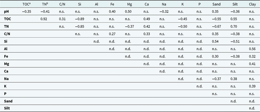
The two main factors responsible for the prevalence of slightly acidic and acidic soils in Longyearbyen are the occurrence of non-calcareous parent material of the studied soils (that is, weathering residues and other deposits originating from sedimentary rocks such as sandstone, siltstone, mudstone and shale) and a locally well-developed vegetation cover, which supplies organic acids to the soils. The lowest soil pH is reported at sites with the best developed vegetation cover. Similar results were previously obtained for soils collected from the Fuglebergsletta coastal plain in the southwestern part of Spitsbergen (Szymański et al., Reference Szymański, Skiba and Wojtuń2013; Szymański, Siwek, Waścińska, & Wojtuń, Reference Szymański, Siwek, Waścińska and Wojtuń2016a). The relationship between soil pH and content of soil organic matter (SOM) is indicated by negative and statistically significant correlation coefficients for TOC and pH and for TN and pH (r = −0.35 and −0.41, respectively; Table 2).
Statistically significant (at p < 0.05) Spearman’s rank correlation coefficients between chemical and physical properties of the studied topsoil horizons

Abbreviations: n.s., not significant at the 0.05 level; n.d., not determined due to compositional character of the data.
a Total organic carbon.
b Total nitrogen.
Content of TOC, TN and C/N ratio
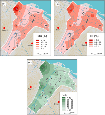
The TOC content of the studied topsoils ranges from 1.38% to 23.52%, with a median of 4.66% (Table 1). The largest surface area of Longyearbyen is occupied by soils exhibiting TOC content less than 10% (Fig. 4A). Topsoils containing higher amount of TOC occur only at some sites in the western and northwestern parts of the city. The lowest TOC content is noted for topsoils occurring along the Longyearelva (<5%). The lowest TOC content reflects the lack of soil development, the newly deposited sediments and the instability caused by river meandering. The impact of soil texture on TOC content is indicated by the obtained negative and significant correlation coefficient for TOC content and the sand fraction (r = −0.55) as well as positive and significant correlation coefficient for TOC content and the silt fraction (r = 0.55; Table 2). Gentsch et al. (Reference Gentsch, Mikutta, Shibistova, Wild, Schnecker, Richter and Guggenberger2015) and Palmtag et al. (Reference Palmtag, Ramage, Hugelius, Gentsch, Lashchinskiy, Richter and Kuhry2016) have also reported a higher content of organic carbon in fine-textured soils in comparison with coarse-textured soils in the Taymyr Peninsula (Northern Siberia). The highest content of TOC in the topsoils of the northwestern part of Longyearbyen is related to the poor drainage of these sites. According to the research literature (for example, Bardgett, Van der Wal, Jónsdóttir, Quirk, & Dutton, Reference Bardgett, Van der Wal, Jónsdóttir, Quirk and Dutton2007; Migała et al., Reference Migała, Wojtuń, Szymański and Muskała2014; Sjögersten, Van der Wal, & Woodin, Reference Sjögersten, Van der Wal and Woodin2006; Szymański et al., Reference Szymański, Skiba and Wojtuń2013, Reference Szymański, Wojtuń, Stolarczyk, Siwek and Waścińska2016b; White, Garland, Dai, & Ping, Reference White, Garland, Dai and Ping2002), the poorer drainage of the soil, the lower the rate of organic matter mineralisation and the higher its accumulation. In addition, a large amount of fine coal fragments lying on the soil surface is responsible for the highest content of TOC in the northwestern part of Longyearbyen.
Content and spatial distribution of total organic carbon (A), total nitrogen (B) and C/N ratio (C) in the topsoils.

The TN content in the studied topsoils ranges from 0.09% to 0.66% with a median of 0.25% (Table 1). Its spatial distribution is very similar to the distribution of TOC (r = 0.92; Table 2, Figs. 4A–4B). The lowest content of TN (<0.20%) is noted for the topsoils occurring along the Longyearelva, which is related to sparse vegetation cover (Fig. 2). The topsoils of the western and eastern parts of the city hold similar amount of TN (0.20-0.40%), because the vegetation cover is similarly developed in these areas. The highest content of TN (>0.40%) occurs at sites with wet moss tundra vegetation exhibiting high moisture due to poor drainage of the soil. The high moisture of the soil and most likely also its lower temperature due to insulating properties of moss cover are responsible for a low rate of organic matter decomposition and accumulation of TN (for example, Bardgett et al., Reference Bardgett, Van der Wal, Jónsdóttir, Quirk and Dutton2007; Sjögersten et al., Reference Sjögersten, Van der Wal and Woodin2006; Szymański et al., Reference Szymański, Skiba and Wojtuń2013, Reference Szymański, Wojtuń, Stolarczyk, Siwek and Waścińska2016b; White et al., Reference White, Garland, Dai and Ping2002).
The C/N ratio in the studied topsoils ranges from 13 to 40 with a median of 19 (Table 1, Fig. 4C). Topsoils with C/N ratio between 15 and 25 occupy the largest area in the Longyearbyen (Fig. 4C). The topsoils with the highest C/N ratio (>30) are located in the northwestern and western part of the city, whereas northeastern part of Longyearbyen is characterised by occurrence of soils exhibiting the lowest C/N ratio (<15) in their topsoil (Fig. 4C). Usually, the C/N ratio is commonly used as an indicator of degree of SOM decomposition. In general, all the studied topsoils are characterised by the quite high or high C/N ratio, which indicates low degree of SOM decomposition due to harsh climate conditions and related to them low activity of soil microorganisms (Dai, Ping, & Michaelson, Reference Dai, Ping and Michaelson2002; Dziadowiec et al., Reference Dziadowiec, Gonet and Plichta1994; Migała et al., Reference Migała, Wojtuń, Szymański and Muskała2014; Szymański et al., Reference Szymański, Skiba and Wojtuń2013, Reference Szymański, Wojtuń, Stolarczyk, Siwek and Waścińska2016b; White et al., Reference White, Garland, Dai and Ping2002). However, in the areas being under impact of coal mining (such as the Longyearbyen area), the C/N ratio is not a useful indicator of SOM decomposition, because fragments of coal deposited on the soil surface could substantially increase the C/N ratio, and also because it is impossible to completely separate all of the fine and very fine coal fragments from the soil material. The obtained results of C/N ratio and its spatial distribution seem to reflect such a situation, because at sites located directly below old coal mines (that is, Gruve 1 and Gruve 2) and in the vicinity of the route of cable car used previously to coal transport to the port, the C/N ratio in topsoils is markedly higher in comparison with other sites (Fig. 4C). It should be noted that coal from Longyearbyen was characterised by the mean C/N ratio of 54 based on the previously published data by Lewińska-Preis et al. (Reference Lewińska-Preis, Fabiańska, Ćmiel and Kita2009). The obtained positive and significant correlation coefficient between the C/N ratio and content of sand fraction (Table 2) was most likely related to the impact of coal fragments occurring in the sand size fraction on the C/N ratio. It was supported by the positive and significant correlation coefficient between the C/N ratio and content of Fe (r = 0.27), because Lewińska-Preis et al. (Reference Lewińska-Preis, Fabiańska, Ćmiel and Kita2009) have shown that coal from Longyearbyen contain pyrite, which has a mean concentration of 3.9%.
Geochemistry
The studied topsoils are mainly composed of Si (32.65-71.88%, with a median of 61.80%), Al (8.79-14.80%, with a median of 12.22%) and Fe (3.72-17.54%, with a median of 5.78%; Table 1). In addition, the studied soil material contains K (1.24-3.75%, with a median of 2.25%), Na (1.05-3.03%, with a median of 1.34%), Mg (0.63-2.69%, with a median of 1.00%), Ca (0.34-11.56%, with a median of 0.54%) and P (0.10-0.28%, with a median of 0.18%; Table 1).
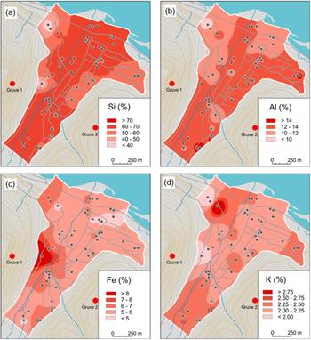
The topsoils occurring along the Longyearelva are characterised by the highest content of Si (>60%; Fig. 5A). A lower content of Si is noted for topsoils from the western, eastern, northwestern and northeastern parts of the town (Fig. 5A). The spatial distribution of Si is connected with soil texture, that is, the higher the content of the sand fraction, the higher the content of Si (r = 0.54), and the higher the silt fraction content, the lower the Si content (r = −0.51; Table 2; Szymański et al., Reference Szymański, Siwek, Waścińska and Wojtuń2016a).
Content and spatial distribution of Si (A), Al (B), Fe (C) and K (D) in the topsoils.

The spatial distribution of Al is shown in Fig. 5B. Topsoils in the northwestern and northern parts of the city exhibit a lower content of Al in comparison with other parts of Longyearbyen. However, almost all the studied topsoils in the city are characterised by a content of Al between 10% and 14% (Fig. 5B). Soils with the highest and the lowest content of Al occur only at some sites, which are scattered in the Longyearbyen city area (Fig. 5B). A positive and significant correlation coefficient for the content of Al and the clay fraction (r = 0.56; Table 2) indicates that the content of Al in the topsoils is closely related to the content of the finest fraction (that is, clay minerals; Szymański et al., Reference Szymański, Siwek, Waścińska and Wojtuń2016a).
The topsoils throughout almost the entire area of Longyearbyen contain Fe, which content ranges from 5.0% to 7.0% (Table 1, Fig. 5C). Slightly lower concentrations of Fe (<5.0%) in the topsoils occur at some sites in the northeastern, northwestern and southern parts of the city (Fig. 5C). However, clearly higher Fe content (17.54%) occurs only at one site in the western part of the study area, and this may be related to the different parent material of the soil, as the highest content of CaCO3 (11.34%) was detected at this site, and the soil material from this site exhibits a different mineral composition (see below) and a clearly more reddish colour (5YR) in comparison with the other soil samples studied (10YR).
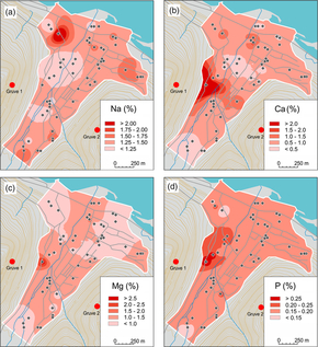
The content of K and Na in the topsoils throughout almost the entire area of Longyearbyen ranges from 2.00% to 2.50% and from 1.00% to 1.75%, respectively (Table 1, Figs. 5D and 6A). The lowest and highest K concentrations in the studied topsoils occur at some sites in the western and northwestern parts of the city (Fig. 5D). Calculated correlation coefficients for K content indicate that its content in soils is positively related to the content of the clay fraction and this means that the higher the content of clay minerals in soils, the higher the content of K (Table 2). The same relationships were obtained by Szymański et al. (Reference Szymański, Siwek, Waścińska and Wojtuń2016a) for surface soil horizons taken from the Fuglebergsletta coastal plain in southwestern Spitsbergen. The lowest Na content occurs mainly along the Longyearelva, which is most likely connected with the leaching and washing out of this element. The highest content of Na is present at sites in the northwestern part of the city (Fig. 6A).
Content and spatial distribution of Na (A), Ca (B), Mg (C) and P (D) in the topsoils.

The spatial distribution of Ca and Mg is shown in Figs. 6B–6C. Almost all of the studied topsoils are characterised by very low content of these elements (<1.50%; Table 1). A slightly higher content of Ca and Mg occurs only at one site in the western part of the city (Figs. 6B–6C), which is related to the highest content of carbonates in the topsoil from this site (11.34%), and may be associated with different (most likely anthropogenic) parent material as described previously. A prevalence of non-calcareous rocks and sediments is a main reason for the very low content of Ca and Mg in the studied topsoils.
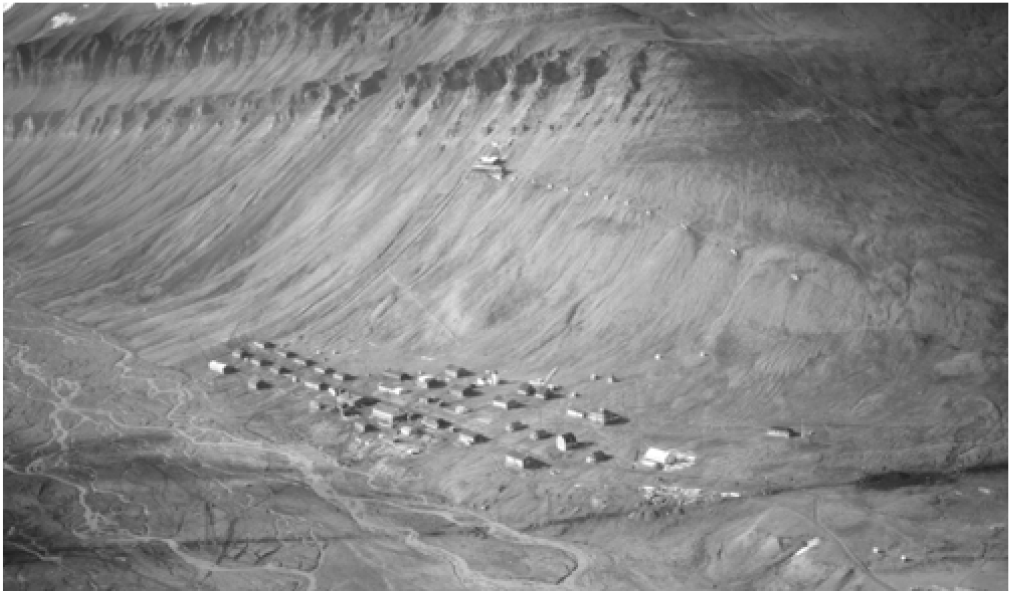
The spatial distribution of P is shown in Fig. 6D. Almost all of the topsoils in Longyearbyen contain a very low amount of P ranging from 0.15% to 0.20%, with a median of 0.18% (Table 1). The highest content of P (> 0.25%) is noted for topsoils located in the western part of the city (Fig. 6D). These sites are located below a colony of little auks (Alle alle), which is found on the steep slopes of Platåberget Mt., and most likely this is the main reason for the highest content of P in the topsoils of this area, as a strong positive impact of seabirds on the P content in topsoils was reported previously at other locations on Spitsbergen (Szymański et al., Reference Szymański, Wojtuń, Stolarczyk, Siwek and Waścińska2016b; Ziółek & Melke Reference Ziółek and Melke2014; Zwolicki, Zmudczyńska-Skarbek , Iliszko, & Stempniewicz, Reference Zwolicki, Zmudczyńska-Skarbek, Iliszko and Stempniewicz2013; Zwolicki, Zmudczyńska-Skarbek, Matuła, Wojtuń, & Stempniewicz, Reference Zwolicki, Zmudczyńska-Skarbek, Matuła, Wojtuń and Stempniewicz2016). The highest content of P at this site may also be connected with the longest impact of human activity on soil cover because this site and its adjacent area are the oldest part of Longyearbyen (Fig. 7).
Location of the first buildings in Longyearbyen; toposvalbard.npolar.no.

Mineral composition
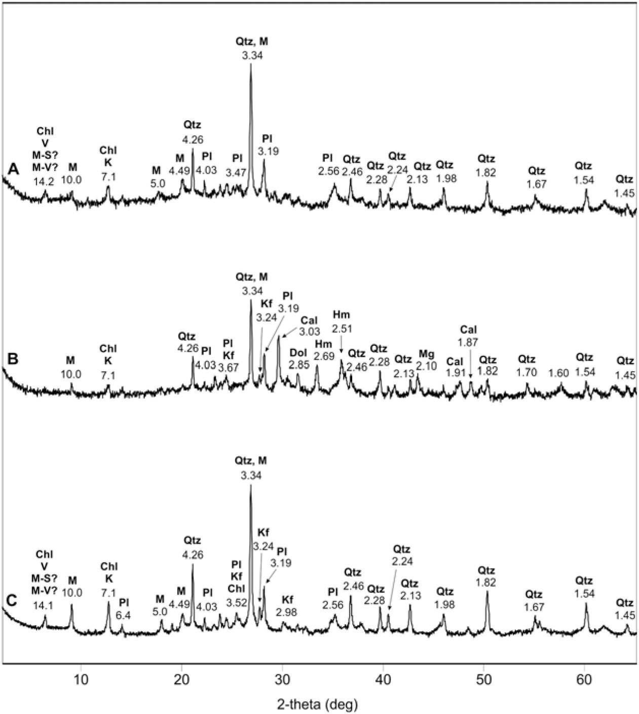
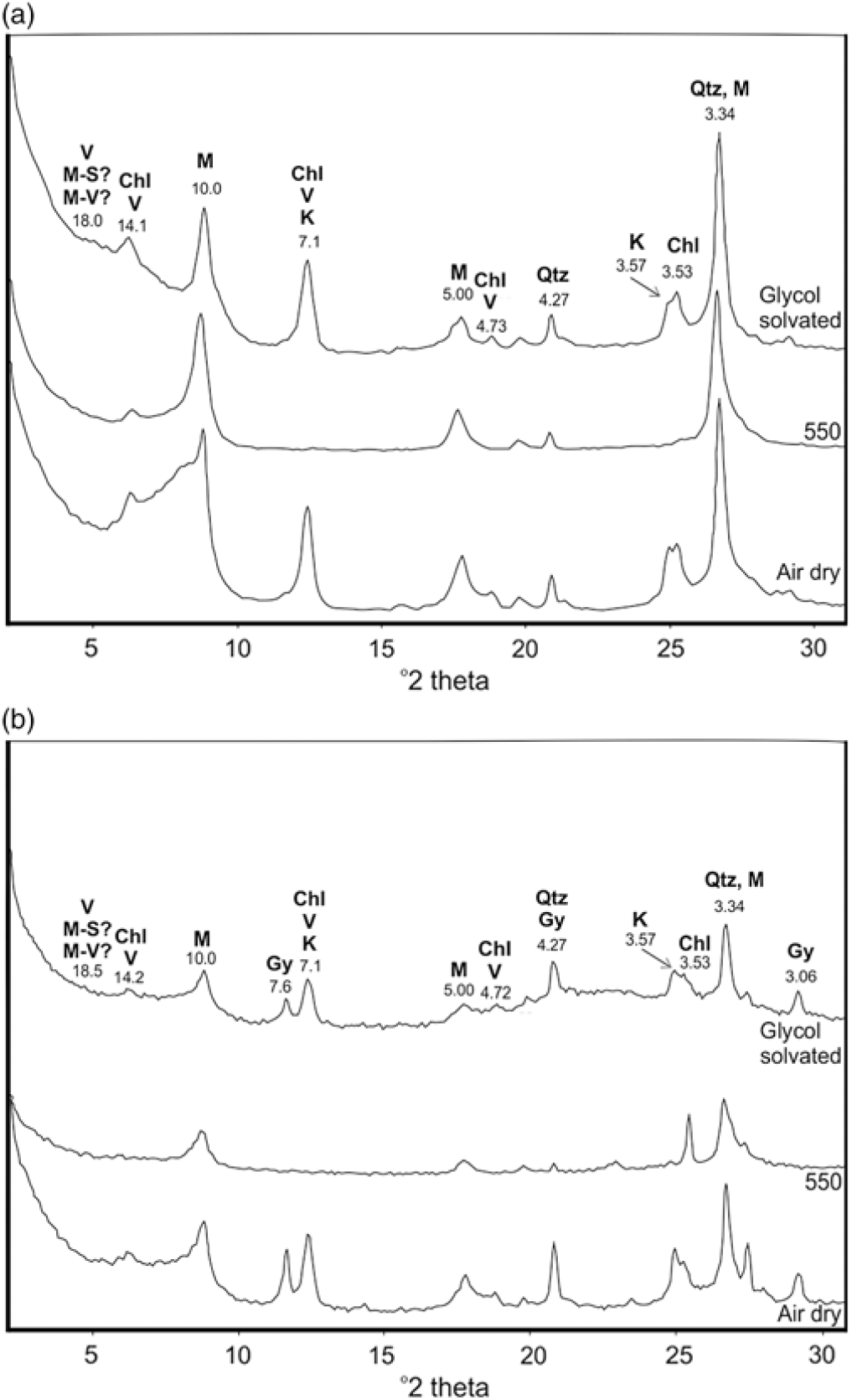
Almost all of the studied topsoils are characterised roughly by the same mineral composition. Quartz, K-feldspar, plagioclase, mica and chlorite are the prevailing minerals (Figs. 8 and 9). Vermiculite and/or mica-vermiculite and/or mica-smectite mixed layered minerals are also present. Only at the one sampling site (site 33), in the western part of Longyearbyen, the soil material was composed of quartz, K-feldspar, plagioclase, mica, chlorite, calcite, dolomite, hematite and magnesite (Fig. 9B). The obtained mineral composition of the soil material from this site indicates a different parent material of the soil and explains clearly the higher pH and higher content of Ca, Mg, Fe and the lower content of Si and K (Figs. 5 and 6). The clay fraction (<2 µm) of the topsoils is composed of chlorite, mica, kaolinite, quartz and small amount of swelling clay minerals such as vermiculite and/or mica-vermiculite and/or mica-smectite mixed layered minerals (Fig. 10). At some sites, gypsum is present in the clay fraction as well (Fig. 10B).
XRD patterns of selected topsoils: A, site 4; B, site 10; C, site 19; Qtz, quartz; M, mica; Pl, plagioclase; Kf, K-feldspar; Chl, chlorite; K, kaolinite; V, vermiculite; M–S, mica–smectite mixed layered mineral; M–V, mica–vermiculite mixed layered mineral.

XRD patterns of selected topsoils: A, site 2; B, site 33; C, site 44; Qtz, quartz; M, mica; Pl, plagioclase; Kf, K-feldspar; Chl, chlorite; K, kaolinite; Cal, calcite; Mg, magnesite; Dol, dolomite; Hm, hematite; V, vermiculite; M-S, mica-smectite mixed layered mineral; M-V, mica-vermiculite mixed layered mineral.

XRD patterns of clay fraction (<2 µm) of the topsoil from sites 51 (A) and 14 (B). Qtz, quartz; M, mica; Chl, chlorite; K, kaolinite; V, vermiculite; M-S, mica-smectite mixed layered mineral; M-V, mica-vermiculite mixed layered mineral; Gy, gypsum.

The mineral composition of the topsoils is inherited from the residues and deposits originating from sedimentary rocks such as sandstone, siltstone, mudstone, and shale, which prevail in the study area (Dallman et al., Reference Dallman, Kjærnet and Nøttvedt2001). The prevalence of quartz, K-feldspar, plagioclase and mica in the topsoils may be explained by the highest resistance of these minerals to weathering (Wilson, Reference Wilson2004) and their predominance in clastic, sedimentary rocks (Haldar & Tišljar, Reference Haldar and Tišljar2014). Most likely, chlorite, kaolinite, and mica are inherited from the parent material and they are not weathering products due to low chemical weathering rate and young soils in the Svalbard archipelago (Kabała & Zapart, Reference Kabala and Zapart2012; Skiba, Drewnik, & Kacprzak, Reference Skiba, Drewnik, Kacprzak, Ziaja and Skiba2002; Szymański et al., Reference Szymański, Skiba, Wojtuń and Drewnik2015). However, the occurrence of small amount of swelling clay minerals (vermiculite and/or mica-vermiculite and/or mica-smectite mixed layered minerals) may be an effect of chemical weathering of mica in the acidic soil environment (Borden, Ping, McCarthy, & Naidu, Reference Borden, Ping, McCarthy and Naidu2010; Szymański et al., Reference Szymański, Skiba, Wojtuń and Drewnik2015; Wilson, Reference Wilson2004). Gypsum, which is present at some sites, is most likely related to precipitation of salts on soil surface due to dry climate conditions of the Longyearbyen area (Beumer et al., Reference Beumer, Varpe and Hansen2017; Christiansen, Reference Christiansen2005; Watanabe et al. Reference Watanabe, Matsuoka, Christiansen and Cable2016). This is in agreement with the results obtained previously by Bryant (Reference Bryant1982), who have also described occurrence of gypsum on soil surface in the Adventdalen. The occurrence of reddish calcareous material in the western part of Longyearbyen is enigmatic and more data (especially historical data concerning coal mining and settlement) are needed to explain the presence of the material at this site.
Conclusions
1. The common texture of the topsoils in the Longyearbyen area include loam, silt loam, sandy loam and loamy fine sand. Topsoils in the western part of the city contain a higher amount of the sand fraction, which is associated with the impact of the local river; whereas topsoils from the eastern part of Longyearbyen exhibit a higher content of the silt and clay fractions, coming most likely from aeolian transport from the Adventdalen.
2. Most of the topsoils exhibit an acidic or slightly acidic reaction, which is related to the prevalence of non-calcareous parent material. Topsoils with neutral or a slightly alkaline reaction occur only at some sites. Topsoils with the lowest pH occur at sites characterised by lush vegetation cover.
3. The content of TOC and TN in the topsoils of the western and eastern parts of Longyearbyen is high due to lush vegetation cover. Sparse vegetation cover, coarse-textured soils and frequent flooding in the area along Longyearelva are responsible for a markedly lower content of TOC and TN. The C/N ratio is quite high and may be related either to low degree of decomposition of SOM due to low microbial activity connected with harsh climate condition and/or impact of coal mining, which might increase content of organic carbon in the soil by anthropogenic deposition of fine and very fine coal fragments at the soil surface. This means that the C/N ratio is not an useful indicator of degree of organic matter decomposition in soils of areas affected by coal mining.
4. Topsoils in Longyearbyen are composed mainly of Si, Al and Fe. In addition, the soil material contains K, Na, Mg, Ca and P. Differences in the concentration of various elements in the topsoils are related to the diversity of texture and mineralogy of the parent material (Si, Al, Fe, K, Na, Mg, Ca) as well as the impact of seabirds and/or the longest human activity (P).
5. Almost all of the topsoils are characterised by the same mineral composition. Quartz, K-feldspar, plagioclase, mica and chlorite are the prevailing minerals. The topsoils containing quartz, K-feldspar, plagioclase, mica, chlorite, calcite, dolomite, hematite and magnesite occur only at some sites in the western part of Longyearbyen. The clay fraction (<2 µm) of the topsoils is composed of chlorite, mica, kaolinite, quartz, vermiculite and/or mica-vermiculite and/or mica-smectite mixed layered minerals. Most likely, chlorite, kaolinite and mica are inherited from the parent material, and the small amount of swelling clay minerals such as vermiculite and/or mica-vermiculite and/or mica-smectite mixed layered minerals may be related to the chemical weathering and transformation of mica in acidic soil environment.
6. The preliminary results of this study indicate that topsoils in Longyearbyen are characterised by the properties inherited from the parent material and are not strongly transformed by human activity. Most likely, human activity in the form of coal mining increased only the concentration of organic carbon in the topsoil at some sites and therefore also increased its C/N ratio. However, pollution of soil with trace elements related to coal mining should be checked and such studies should be planned in the nearest future.
Acknowledgements
The authors thank Joanna Waścińska, Kinga Mielcarska, Kornelia Stadnik, Maria Kolon, Monika Wołczecka, Sylwia Kacperska, Marcin Kopeć and Damian Celiński for their help during field studies. The authors would also like to thank Katarzyna Maj-Szeliga from the Institute of Geological Sciences at Jagiellonian University in Kraków, Poland, for collection of X-ray patterns of the clay fraction. The authors thank anonymous reviewers for their helpful suggestions. Language editing was done by Grzegorz Zębik.