The pre-Hispanic Maya city of Chunchucmil, Yucatan, Mexico, grew to become one of the most densely settled cities of the Maya area during the middle of the Classic period (a.d. 400–650). Since the first report of Chunchucmil in the archaeological literature in the late 1970s (Vlcek et al. Reference Vlcek, de Gonzalez, Kurjack, Harrison and Turner1978), the most striking feature of this site has been the presence of an unusually dense settlement covering at least 12 km2 in such an agriculturally marginal environment. The paradox between the extremely dense settlement, clearly visible in the aerial photographs, and the limited agricultural environment has attracted the Pakbeh Regional Economy Project (PREP) to this area from 1993 to 2006. After 12 field seasons of research at Chunchucmil and its surrounding region, we have gained a much clearer understanding of this site and its region. First, we will describe the settlement patterns of this densely settled urban site, focusing on the characteristics, composition, and variability of Late Early Classic and Early Late Classic residential groups. Then, we will explore how Chunchucmil's residents may have experienced their urban environment during its largest occupation in the middle of the Classic period.
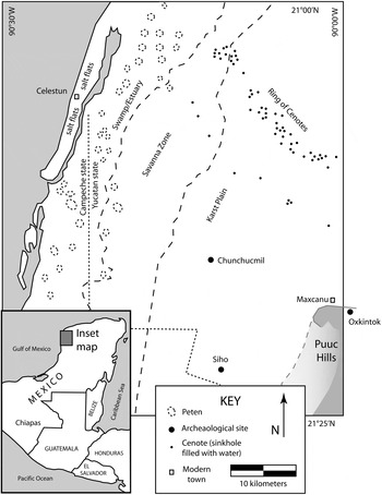
Chunchucmil is located in the driest portion of the Maya region, the northwest corner of the Yucatan peninsula (Figure 1). This is a region with low rainfall, shallow and sparse soils, abundant bedrock, high evapotranspiration, and thus low agricultural potential (Beach Reference Beach1998; Dahlin et al. Reference Dahlin, Beach, Luzzadder-Beach, Hixson, Hutson, Magnoni, Mansell and Mazeau2005; Sweetwood et al. Reference Sweetwood, Beach, Dahlin and Terry2009; Vlcek et al. Reference Vlcek, de Gonzalez, Kurjack, Harrison and Turner1978). Palaeoclimatic studies indicate that conditions were similar in the past, particularly during the late Early Classic period (Curtis et al. Reference Curtis, Hodell and Brenner1996; Folan et al. Reference Folan, Gunn, Eaton and Patch1983a; Gunn et al. Reference Gunn, Folan, Robichaux and Folan1994, Reference Gunn, Folan and Robichaux1995; Hoddell et al. Reference Hodell, Curtis and Brenner1995; Leyden et al. Reference Leyden, Brenner, Curtis, Piperno, Whitmore, Dahlin and Fedick1996; Whitmore et al. Reference Whitmore, Brenner, Curtis, Dahlin and Leyden1996). Despite these limitations, the site of Chunchucmil became a major population center with one of the highest population densities recorded for the Maya region during the middle of the Classic period. Located only 27 km from the coast and just east of the seasonally inundated savannah at the beginning of the karst plain, Chunchucmil was strategically situated near the edge of several ecological zones rich in natural resources. PREP's research has shown that Chunchucmil actively participated in maritime trade along the Gulf Coast, exploited the coastal salt flats, and functioned as a regional exchange center (Dahlin Reference Dahlin2003; Dahlin and Ardren Reference Dahlin, Ardren, Masson and Freidel2002; Dahlin et al. Reference Dahlin, Andrews, Beach, Bezanilla, Farrell, Luzzadder-Beach and McCormick1998), all of which promoted a large population in this agriculturally marginal environment.
Map of the Chunchucmil region.

CHUNCHUCMIL AS AN URBAN CENTER
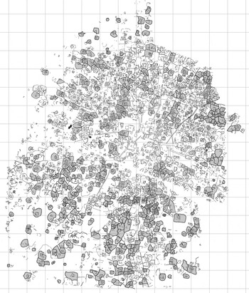
From 1996 to 2006, Bruce Dahlin, Scott Hutson, and Aline Magnoni supervised the mapping of a total of 11.77 km2 of the archaeological site of Chunchucmil (Hutson et al. Reference Hutson, Hixson, Magnoni, Mazeau and Dahlin2008). The mapped area includes a contiguous block of 9.4 km2 (Figure 2) and five transects that extend beyond the central block. The five transects—four of them 300 m wide and the fifth 200 m wide and extending for 0.6–2 km from the central block—were mapped to estimate the site boundaries. With these transects, satellite imagery, and aerial photography we have estimated the urban portion of Chunchucmil to cover an area of 20–25 km2 (Hutson et al. Reference Hutson, Hixson, Magnoni, Mazeau and Dahlin2008).
Map showing the sample of 392 completely bounded houselots in the 9.4 km2 of mapped Chunchucmil. (Grid squares are 250 × 250 m.)

The “site center” consists of several groups of monumental architecture dispersed over the central square kilometer. An area we refer to as the “residential core” surrounds the site center (Hutson et al. Reference Hutson, Hixson, Magnoni, Mazeau and Dahlin2008). The residential core was distinguished by the presence of residential groups delimited by stone boundary walls and streets that allowed traffic among the tightly bound groups. Because of the high density of occupation, a single stone boundary wall would be shared by the residential group on either side of it. In Becker's (Reference Becker, Ruiz, de León and Martínez2001) typology of houselot delineators, this spatial pattern superficially resembles Model A. In this model, there is little or no public space between houselots. In other words, houselots are contiguous with one another. Becker's model A assumes that social ties between houselots were so tight that people from one houselot would have unrestricted access to their neighbors' houselots. Although cooperation would be necessary to maintain the shared boundary walls at Chunchucmil, data presented below suggest that each houselot had a rather distinct identity, which is to say that social ties would not have been as tight as Becker's Model A presumed. Beyond the residential core, structure density diminished and open spaces were left between bounded residential groups, like at Coba (Folan et al. Reference Folan, Kintz and Fletcher1983b) (Figure 2). This type of settlement pattern has been referred to as the “residential periphery” (Hixson and Mazeau Reference Hixson and Mazeau2005; Hutson et al. Reference Hutson, Hixson, Magnoni, Mazeau and Dahlin2008). In the residential periphery many houselots did not share boundary walls, and streets were no longer needed since people could easily move in the empty spaces between residential groups, probably along trails which have long since disappeared. The area containing the residential core and residential periphery covered 17 km2. At the outer edge of the residential periphery, settlement density dropped from 350 structures per km2 to 50 structures per km2. Fingers of settlement with a density greater than 50 structures per km2 though less than 350 structures per km2 extended farther from the site center, usually in the direction of outlying sites. These fingers add an area of 3–8 km2 to urban Chunchucmil, whose size would have been 20–25 km2 (Hixson et al. Reference Hixson, Mazeau and Pope2006; Hutson et al. Reference Hutson, Hixson, Magnoni, Mazeau and Dahlin2008). Beyond these 20–25 km2 we have defined Greater Chunchucmil, a portion of the hinterland settlement with stronger economic and social connections with the city, extending 5 km from Chunchucmil's center (Hutson et al. Reference Hutson, Hixson, Magnoni, Mazeau and Dahlin2008).
The estimated population for the 20–25 km2 of urban Chunchucmil is 34,000 to 43,000 people—the calculations for which have been reported in detail elsewhere (see Magnoni Reference Magnoni, Clark and Hagemeister2007). Our calculations followed standard procedures for population estimates in the Maya area (Rice and Culbert Reference Rice, Culbert, Culbert and Rice1990) and are likely conservative. These results indicate that Chunchucmil was the most densely settled Classic period Maya site (Rice and Culbert Reference Rice, Culbert, Culbert and Rice1990), despite its location in a marginal environment. Although the central core of Copan has higher density than Chunchucmil, this is only 0.6 km2 of settlement compared to 7 km2 of residential core at Chunchucmil. In fact, only 18,000 to 25,000 people are estimated to have lived in the whole 500 km2 of the Copan Valley during the Late Classic period (Webster and Freter Reference Webster, Freter, Culbert and Rice1990). To put Chunchucmil's settlement density in perspective we can compare it to Tikal, where the highest estimates suggest that 62,000 people lived over an area of 120 km2 (Culbert et al. Reference Culbert, Kosakowsky, Fry, Haviland, Culbert and Rice1990; but see also Becker Reference Becker and Sabloff2003; Haviland Reference Haviland1970, Reference Haviland and Sabloff2003). According to this estimate 8,300 people lived in the central 9 km2 at Tikal, while, three times as many people (ca. 25,000 people) lived in the central 9 km2 at Chunchucmil. Other estimates for Tikal population are much lower and range from 25,000 (Becker Reference Becker and Sabloff2003) to 45,000 (Haviland Reference Haviland1970, Reference Haviland and Sabloff2003). Chunchucmil residents were able to support such high population density in this limited agricultural environment because of their reliance on commerce: by being strategically located with respect to the exploitation of coastal and savannah resources (especially salt), by redistributing traded goods to the interior, and by provisioning maritime and overland traders (Dahlin Reference Dahlin2003; Dahlin and Ardren Reference Dahlin, Ardren, Masson and Freidel2002; Dahlin et al. Reference Dahlin, Andrews, Beach, Bezanilla, Farrell, Luzzadder-Beach and McCormick1998; Hutson et al. Reference Hutson, Dahlin, Mazeau and Marshall2010).
CHARACTERISTICS, COMPOSITION, AND VARIABILITY OF LATE EARLY CLASSIC AND EARLY LATE CLASSIC RESIDENTIAL GROUPS
We turn now to the description and analysis of the characteristics, composition, and variability of the late Early Classic–early Late Classic residential groups, which were part of the dense urban settlement of Chunchucmil. We have mapped approximately 1,100 of these residential groups, but here we will use a representative sample of 392Footnote 1 groups (36%) that were completely bounded by a stone wall (Figure 2 and Appendix 1). The clear delineation of residential groups by a boundary wall for this time period at Chunchucmil allows the identification of the basic coresidence units where activities were carried out by household members. Households are “task-oriented residence units” (Netting et al. Reference Netting, Wilk and Arnould1984:xxvi), whose main functions are production, distribution, transmission, and reproduction (Wilk and Ashmore Reference Wilk and Ashmore1988; Wilk and Rathje Reference Wilk and Rathje1982). Since households are the basic organizational units of society and the result of adaptive domestic strategies to meet the needs of its members (Wilk and Rathje Reference Wilk and Rathje1982:618), we can gain knowledge on the wider community by analyzing household characteristics (Allison Reference Allison1999; Blanton Reference Blanton1994; Santley and Hirth Reference Santley and Hirth1993). Therefore we explore structural composition, use of space, cost of construction, and layout in the settlement within these residential groups of the middle part of the Classic period.
Bounded Houselots: Albarradas
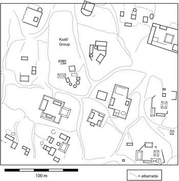
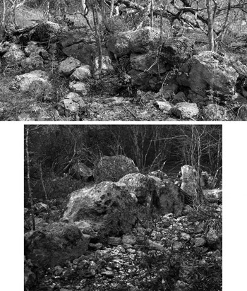
During the late Early Classic period and the first part of the Late Classic period, residential groups consisted of a few structures arranged around a common patio, similar to other sites in the Maya area (Ashmore Reference Ashmore and Ashmore1981) (Figure 3). The distinctive characteristic of Chunchucmil's residential groups is that they were delimited and enclosed by stone walls—albarradas, dry laid stone walls (Magnoni Reference Magnoni1995; Vlcek Reference Vlcek1978)—and that streets, created by parallel running walls, directed traffic in the crowded urban landscape (Figures 3 and 4). For the most part, albarradas were not common at Classic period Maya sites, but they became more common at Postclassic east coast sites and Mayapan. During the Classic period albarradas enclosed structures at Coba (Benavides Castillo and Manzanilla Reference Benavides Castillo, Manzanilla and Manzanilla1987; Folan et al. Reference Folan, Kintz and Fletcher1983b; Gallareta Negrón Reference Gallareta Negrón1984), Dzibilchaltun (Kurjack Reference Kurjack1974; Kurjack and Garza Tarazona Reference Kurjack, Tarazona and Ashmore1981), Becan (Thomas Reference Thomas1981), the Río Bec region (Turner Reference Turner1983), Cuca (Kurjack and Garza Tarazona Reference Kurjack, Tarazona and Ashmore1981), and Calakmul (Folan et al. Reference Folan, Fletcher, Hau, Gunn, Tiesler, Mastache, Cobean, Cook and Hirth2008). At these sites, however, albarradas were not as extensive and were rarely shared between groups. Less extensive albarrada systems have been reported from Terminal Classic Chichen Itza (Schmidt Reference Schmidt1981), Uxmal (Barrera Rubio Reference Barrera Rubio1981), and Santa Barbara (Stanton et al. Reference Stanton, Carrillo, Gallareta, Eberl, Alvarez and Pacheco2003). In the Postclassic period, albarradas that were shared between residential groups (similar to Chunchucmil) and, in some cases, a few streets were present at Mayapan (Bullard Reference Bullard1952, Reference Bullard1954; Smith Reference Smith1962) and East Coast sites like Tulum (Benavides Castillo Reference Benavides Castillo1981; Goñi Motilla Reference Goñi Motilla1993; Vargas et al. Reference Vargas, Santillan and Vilalta1985), Xcaret (Andrews and Andrews Reference Andrews and Andrews1975; Con Uribe Reference Con Uribe1991), Xamanha (Goñi Motilla Reference Goñi Motilla1993; Silva Rhoads and Hernandez Reference Silva Rhoads and del Carmen Hernández1991), and Cozumel (Freidel and Sabloff Reference Freidel and Sabloff1984; Sierra Sosa Reference Sierra Sosa1994). Many of the bounded enclosures along the east coast were devoid of structures and seem to have contained agricultural fields.
Neighborhood of residential groups enclosed by stone boundary walls—albarradas—and with streets.

Examples of albarradas: (top) an albarrada built with stones piled on top of each other, and (bottom) an albarrada built by a single course of large boulders.

Bounded Houselots: Chichbes
At Chunchucmil, besides albarradas, there were also narrow, raised, winding causeways (less than 1 m high and .5–3 m wide), which we have called chichbes (Figures 5–7). At other sites these features have been referred to as “andadores,” or walkways (Benavides Castillo Reference Benavides Castillo1981; Goñi Motilla Reference Goñi Motilla1993; Vargas et al. Reference Vargas, Santillan and Vilalta1985), but we prefer the more neutral term of chichbeh, which does not explicitly refer to function. Chichbes were built like sacbes, with two parallel courses of roughly cut stones containing small rubble to provide a leveled surface, but unlike sacbes, they were narrower and tended to wind around residential groups similar to albarradas. Chichbes involved considerably more labor to build than albarradas and were less common. We have recorded 43 km of chichbes compared to just over 200 km of albarradas in the 9.4 km2 mapped by PREP.
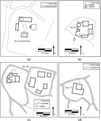
Examples of small albarrada groups, houselots enclosed by stone boundary walls, containing 1–5 structures. Examples (a) and (b) are completely bounded by an albarrada, and examples (c) and (d) are completely bounded by a chichbeh. Note the eastern shrine in example a and the possible eastern shrine in example b.

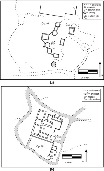
Examples of medium albarrada groups, houselots enclosed by stone boundary walls, with 6–10 structures. Example (a) is bounded by an albarrada and example (b) by a chichbeh.

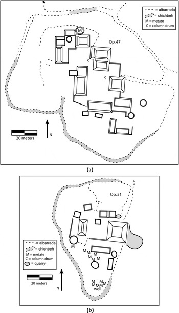
Examples of large albarrada groups, houselots enclosed by stone boundary walls, with more than 10 structures. Both groups are bounded by a combination of albarrada and chichbeh.

We believe that at some point in their life cycle chichbes were used mainly as albarradas to mark boundaries around houselots, since albarradas and chichbes often transformed into each other around the same residential group (Figure 7b). In other words, part of the bounding apparatus around a residential group was an albarrada, while part might have been a chichbe. In these cases chichbes may have been used as planting surfaces for cacti such as nopal or other plants in order to provide a definite and tall boundary delineation but also to provide well–drained planting areas for economically viable plants (such as nopal, on which cochineal, the natural dye, grows). In other cases, though, chichbes were also used as walkways since they continued into streets or callejuelas (Figure 7a). Morphologically streets are clearly recognizable from chichbes since they were created by parallel albarradas, 2–5 meters wide, which delimited many densely clustered walled residential groups. Although streets did not have a pavement or raised area to walk on, chichbes did provide such a raised (30–70 cm high) and leveled area. These raised areas may have been used as walkways during the rainy season when the landscape flooded easily.
Bounded Houselots: Solares
The residential groups bounded by albarradas at Chunchucmil are similar to modern solares—household gardens—in Yucatan and Mesoamerica, where a variety of domestic activities take place (Anderson Reference Anderson and Hostetter1996; Caballero Reference Caballero1992; Herrera Castro Reference Herrera Castro1993, Reference Herrera Castro1994; Ortega et al. Reference Ortega, Avendaño, Gómez-Pompa and Ucán Ek1993; Rico-Gray et al. Reference Rico-Gray, Franco, Chemas, Puch and Sima1990; Smyth Reference Smyth1990; Stuart Reference Stuart1993). In modern solares, however, the main residence is generally placed along the albarrada with the main house doorway facing the street and providing access to the habitational area (Magnoni Reference Magnoni1995; Vlcek Reference Vlcek1978). In pre-Hispanic Chunchucmil structures were not adjacent to the boundary walls but, rather, they tended to be arranged away from the walls (Magnoni Reference Magnoni1995). Contemporary solares in Yucatan and Mesoamerica have one to two residences, a kitchen, sometimes a separate structure to be used as a bathroom, an area for washing clothes, storage facilities (mostly for corn), animal pens, apiaries, and, in some cases, a small domestic shrine. The area around the residence is used for a variety of everyday activities, such as food preparation, washing clothes, tending animals, processing agricultural products, and craft activities (e.g., pottery, basketry) (Anderson Reference Anderson and Hostetter1996; Arnold Reference Arnold1990; Caballero Reference Caballero1992; Hayden and Cannon Reference Hayden and Cannon1983, Reference Hayden and Cannon1984; Herrera Castro Reference Herrera Castro1993, Reference Herrera Castro1994; Killion Reference Killion1990; Ortega et al. Reference Ortega, Avendaño, Gómez-Pompa and Ucán Ek1993; Rico– Gray et al. Reference Rico-Gray, Franco, Chemas, Puch and Sima1990). In addition, solares contain an area of intensive or horticultural management, where economically useful species are grown close to the living quarters and a portion of the garden containing trees that often mimic the forest composition, and other useful economic species (Anderson Reference Anderson and Hostetter1996; Barrera Rubio Reference Barrera Rubio1981; Caballero Reference Caballero1992; Herrera Castro Reference Herrera Castro1993, Reference Herrera Castro1994; Ortega et al. Reference Ortega, Avendaño, Gómez-Pompa and Ucán Ek1993; Rico–Gray et al. Reference Rico-Gray, Franco, Chemas, Puch and Sima1990).
Sample of Bounded Houselots under Study
While the total number of mapped residential groups at Chunchucmil is approximately 1,100, here we only consider those houselots that were completely and unambiguously enclosed by stone walls. There are 392 of these bounded houselots in the 9.4 km2 entered in the geographic information system (GIS)Footnote 2 database (Figure 2 and Appendix 1). Ancient and modern occupation has in some cases disturbed the residential groups, making it difficult to distinguish which houselot belonged to certain structures and how much of the empty garden area pertained to a specific group. By selecting only houselots that were unequivocally delimited by albarradas or chichbes, we can safely calculate the archaeological and natural features contained in each of these houselots, the area enclosed by stone walls, the total area and the total volume covered by architecture within each bounded houselot, and compare the variation across the site.
Of these residential groups 115 (29% sample) have been tested with off-mound test pits, while four have undergone extensive excavations, confirming that these groups were contemporaneous domestic units in the late Early Classic period and the first part of the Late Classic period. The presence of shared albarradas between contiguous groups and streets meandering among the walled residential groups throughout the site suggest contemporaneity of the habitational units. Extensive excavations at these groups have revealed a close association between Oxkintok Temprano and Proto-Puuc architecture and the ceramics of late Early Classic and early Late Classic transition (a.d. 500–650/700). The most common ceramics were the Maxcanu group (especially Tiznuk Composite, Yaxuna Preslateware, and Maxcanu Ante), Hunabchen group, Oxkintok Fine Wares (Chencoh group, Kochol group, and Acu group), and Oxil group. Two bone collagen samples have yielded the only radiocarbon dates at the site. A radiocarbon date of 1550 ± 40 b.p. (calibrated at 2σ a.d. 420–610) obtained from burnt animal bone was taken from the floor of residential Structure 76 in the Lool Group (Ardren et al. Reference Ardren, Lowry, Hutson, Hutson and Magnoni2013), while a human bone from Burial 1 at the base of the residential vaulted Structure 32 at the Kaab' Group was dated to 1392 ± 76 b.p. (calibrated at 2σ a.d. 436–806). These two dates support the ceramic and architectural dating of these albarrada groups to the late Early Classic and early Late Classic periods.
Bounded Houselots: Architectural Composition
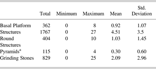
The 392 bounded houselots analyzed in this paper were evenly distributed across the site (Figure 2 and Appendix 1). These albarrada groups contained a total of 2,286 structures (excluding 362 basal platforms), 829 grinding stones (805 metates and 24 querns, grinding stones with a circular depression and side spillway), and 144 quarries (including 43 sascaberas—pockets of sascab or gravel), 15 rejolladas (karst depression with rich accumulation of soil at the bottom), but only two identified ancient wells (Table 1 and Appendix 1). These 392 bounded houselots covered a cumulative area ca.1.65 km2 and contained 290,114 m3 of architectural features.
Summary of features contained in the sample of completely bounded houselots
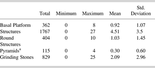
aStructures taller than 2.5 m generally with a square plan were entered as pyramids in the GIS database.
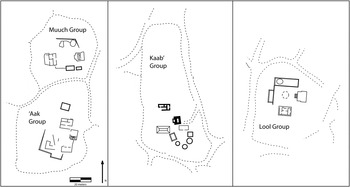
According to PREP's classification, albarrada groups fall into three categories: (1) small albarrada group containing 1–5 domestic structures (Figure 5), (2) medium albarrada group with 6–10 domestic structures (Figure 6), and, (3) large albarrada group with more than 10 domestic structures (Figure 7). Of the 392 bounded houselots used as a representative sample for the rest of the site, 192 (49%) were small albarrada groups, 144 (37%) were medium, and 56 (14%) were largeFootnote 3. The average bounded houselot contained one basal platform, five structures, one round structure, and in one-third of the bounded houselots a pyramid (a generally square structure taller than 2.5 m), mostly arranged around a common patio (Table 1).Footnote 4 In addition, 34% of these residential groups had chich piles, low (< 20 cm) accumulations of small rubble, which may have been the foundations for small perishable structures (see Ringle and Andrews Reference Ringle, Andrews, Culbert and Rice1990). The large variation in the number of structures inside the bounded houselots throughout the site indicates that household composition varied considerably, as seen at other Maya sites (Benavides Castillo Reference Benavides Castillo and Manzanilla1987; Kintz Reference Kintz, Folan, Kintz and Fletcher1983; Kurjack Reference Kurjack1974; Tourtellot Reference Tourtellot, Vogt and Leventhal1983). The spatial arrangement of the houselots reflects the final stage of household members' organization and residency patterns prior to abandonment (Haviland Reference Haviland, Wilk and Ashmore1988; Tourtellot Reference Tourtellot, Wilk and Ashmore1988). We retrieved some information on the domestic cycle through extensive excavations in four domestic groups (Kaab', ‘Aak, Muuch, and Lool Groups) (see Figure 8) (Hutson Reference Hutson2010; Magnoni Reference Magnoni2008). The average composition of bounded houselots at Chunchucmil, with two to three residential structures, one to two ancillary structures, and often a domestic shrine (see below), suggests that the majority of households were most likely composed of extended families. In the case of residential groups with a large number of structures, the presence of more than one patio, around which structures were arranged, also indicates that they were inhabited by more than one nuclear family.
Maps of the extensively excavated houselots as representative of the average houselot at Chunchucmil.

Bounded Houselots: Eastern Domestic Shrines
Many of the albarrada groups had a structural arrangement similar to Plaza Plan 2 (PP2), as defined by Becker (Reference Becker1971, Reference Becker1982, Reference Becker1991, Reference Becker1999, Reference Becker and Sabloff2003) at Tikal. PP2s are identified by having a principal diagnostic structure located at the center of the eastern side of the plaza (Figure 8). These eastern structures were characterized by a square plan (rather than a rectangular plan like other structures in the same group), they tended to be the tallest structure in the group, and they always contained several burials and caches associated with new construction episodes. These structures are interpreted to be shrines or adoratorios (Becker Reference Becker1971, Reference Becker1982, Reference Becker1991, Reference Becker1999, Reference Becker and Sabloff2003; see also Leventhal Reference Leventhal, Levanthal and Kolata1983; Tourtellot Reference Tourtellot, Vogt and Leventhal1983). At Chunchucmil, extensive excavations at five albarrada groups show that the eastern structure was a shrine and the focus of ritual activities at the group, with architectural remodeling, ancestor burials, and dedicatory offerings (Hutson Reference Hutson2010; Hutson et al. Reference Hutson, Magnoni and Stanton2004; Magnoni Reference Magnoni2008). Our excavations have revealed that the eastern location along the patio and the square shape are the best predictors of an east structure being a shrine. In contrast to Tikal, Copan, and Barton Ramie (Becker Reference Becker1971, Reference Becker1999; Leventhal Reference Leventhal, Levanthal and Kolata1983), the eastern shrines at Chunchucmil were not always the highest structures in the group.
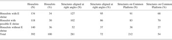
One hundred and thirty four (34%) of these bounded houselots had clearly identifiable eastern shrines (recognizable by their square form and placement along the east side of the patio and, only in some cases, greater height than other structures in the group) (Table 2; Figures 5a, 7, 8, and 11; Appendix 1). In addition, 118 (30%) residential groups had possible eastern shrines (Figure 5b; Appendix 1). These possible eastern shrines exhibited only one of the characteristics that would distinguish them as shrines: (1) they were placed along the eastern side of the patio but had a rectangular (instead of square) shape, and, (2) they had a square form but were not well aligned along the eastern side of the patio, in some cases forming part of complex architectural arrangements. In the remaining 140 residential groups (36%) there were no eastern shrines that could be identified by architectural characteristics and layout within the group. If we consider the number of residential groups with a clearly identifiable eastern shrine (34%) and those that may have had one (30%), almost two-thirds (64%) of residential groups at Chunchucmil had this characteristic component of the domestic layout. This is similar to what has been suggested for Caracol, where as many as 60% of the architectural groups may have an eastern shrine (Chase and Chase Reference Chase, Chase, Robertson and Fields1994). On the other hand, at Tikal only 14% of the architectural groups (96 out of 690) showed a PP2 or residential groups with an eastern shrine (Becker Reference Becker1982, Reference Becker1999).
Sample of bounded houselots showing presence of eastern shrine, alignment of structures and presence of common platform as an indication of social cohesiveness

The domestic shrines that are present in a large number of residential groups at Chunchucmil would have housed buried ancestors, household heirlooms, and dedicatory offerings. In addition, these shrines would have served as an important place for domestic rituals activities (see Hutson Reference Hutson2010, Hutson et al. Reference Hutson, Magnoni and Stanton2004, and Magnoni Reference Magnoni2008). The communal ritual practices conducted by household members at these shrines would have functioned to cement household identity. Many of the groups without an eastern shrine were small in size and contained few structures, suggesting that households needed a certain number of members before erecting these buildings. Alternatively, the small habitational groups may have been recently founded and thus may not have had any dead ancestors to bury. In the other houselots where many structures were present but we could not identify a domestic shrine, shrines may have been present but in a different location within the group and with different architectural characteristics. A large majority (84%) of the houselots with definite eastern shrines had three or more structures, which could have been residential. If we estimate that one family was residing in a residential structure, then several families would have been living together in these houselots. The practices and the rituals carried out at the eastern shrine by houselots families would have reinforced a common household identity. In addition, the architectural data from the extensively excavated residential groups indicates the presence of a distinctive architectural style in each group, which would have contributed further in underscoring the individual household identity (Hutson et al. Reference Hutson, Magnoni and Stanton2004).
The presence of a domestic shrine is strongly correlated with residential groups that show a strong degree of social coherence. Wilk (Reference Wilk1983, Reference Wilk, Netting, Wilk and Arnould1984) has argued that social coherence of households can be measured by the degree of spatial organization. Individual families that were integrated and unified within a single household had buildings spaced closer together and organized around a coherent plan. In the archaeological record we can measure this by looking at the alignment and spatial disposition of structures in the residential groups (Hutson et al. Reference Hutson, Magnoni, Mazeau, Stanton, Mathews and Morrison2006). At Chunchucmil, 95% of the houselots with a domestic shrine had buildings arranged at right angles around one or more common patios, indicating that strongly integrated households with a high degree of social coherence also erected a domestic shrine (Table 2). The remaining houselots with a domestic shrine (7 out of 134) either had round structures arranged around a patio, which are not as easily aligned, or had some—but not all—structures in some kind of alignment. In addition, 68% of the residential groups with an eastern shrine also shared a platform on top of which sat the aligned buildings. The number of common platforms could be higher, since low platforms may have been present in many other cases but not recorded in our map. Our extensive excavations in residential groups have revealed common platforms that had not been detected during the mapping process. Of the 118 houselots with a possible eastern shrine, 86% had buildings aligned at right angles, nine showed partial alignment of some buildings, and the remaining seven showed no alignment of buildings. In 70% of the residential groups with a possible domestic shrine, buildings shared a common platform.
These data show that almost all bounded habitational units with a definite or possible domestic shrine had buildings aligned at right angles and a large majority shared a platform on top of which sat the buildings. The spatial organization of the domestic space around a coherent plaza plan, or a distinctive architectural grammar (PP2, as defined by Becker [Reference Becker1971, Reference Becker1999, Reference Becker and Sabloff2003]), indicate that these residential groups had a strong degree of social cohesiveness. On the other hand, of the 140 residential groups without an eastern shrine, only 52 had structures aligned at right angles, and 38 had platforms arranged on top of a common platform. These are much lower percentages (37% and 27%, respectively) than those of houselots with definite and possible eastern shrines, indicating that residential groups without a domestic shrine had a lesser degree of social integration and cohesiveness.
Bounded Houselots: Aerial and Volume Measurements
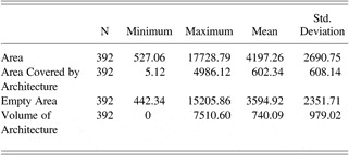
The area of these 392 enclosed houselots ranges from 527 m2 to 17,729 m2 (Table 3), although only 10 houselots have an area smaller than 1,000 m2 and only 17 houselots have an area larger than 10,000 m2 (Appendix 1). The area of 89% of these bounded houselots falls between 1,000 and 8,000 m2 with an average area of 4,200 m2 (Appendix 1). At Coba, the only other Classic period site with an extensive network of albarradas enclosing residential groups, the area of the bounded houselots (n = 144) ranges from 20 to 9,077 m2, with 72% of the houselots having an area smaller than 1,000 m2 (Fletcher Reference Fletcher, Folan, Kintz and Fletcher1983b; Fletcher and Kintz Reference Fletcher, Kintz, Folan, Kintz and Fletcher1983). These are significant differences: at Chunchucmil the average bounded houselot (4,200 m2) is considerably larger than at Coba (1795 m2)Footnote 5 (Goñi Motilla Reference Goñi Motilla1993). At densely occupied Postclassic Mayapan, the average area of houselots is 845 m2, also considerably smaller than at Chunchucmil (Bullard Reference Bullard1954).Footnote 6 A small area enclosed in bounded houselots is a common characteristic of Postclassic sites, probably as a result of the higher density of settlement.
Statistics of the sample of completely bounded houselots

Even though structure density diminishes with increased distance from the site center, the size of these houselots does not correlate with distance from the site center (Pearson's r = 0.028, p = 0.582) (see also Hutson et al. Reference Hutson, Magnoni, Mazeau, Stanton, Mathews and Morrison2006). Small houselots can be located close to the densely occupied site center as well as in the more dispersed peripheral areas of the site. As already noted, as one moves away from the site center, however, the space between walled houselots increases, therefore eliminating the need for streets in these less dense portions of the site. At Coba, on the other hand, there is a small positive correlation between the size of the houselot and the distance from the site center (Fletcher and Kintz Reference Fletcher, Kintz, Folan, Kintz and Fletcher1983; Goñi Motilla Reference Goñi Motilla1993).
What is of real interest to us is the area that is not covered architectural remains, or the empty area, of each bounded houselot. In the tropics many social, economic, and ritual activities take place outside of buildings, so it is important for archaeologists to recognize that outdoor areas should be an intrinsic part of analyses of domestic practices (Ball and Kelsay Reference Ball, Kelsay and Killion1992; Hendon Reference Hendon1991; Hutson et al. Reference Hutson, Stanton, Magnoni, Terry and Craner2007; Killion et al. Reference Killion, Sabloff, Tourtellot and Dunning1989; Manzanilla Reference Manzanilla1987; Parnell et al. 2002a; Pool Reference Pool, Stark and Arnold1997; Robin Reference Robin2002; Smyth et al. Reference Smyth, Dore and Dunning1995). These empty areas, like modern bounded houselots in Yucatan and other parts of Mesoamerica, could have been used for a variety of activities such as gardening, craft production, storage, cooking, washing clothes, garbage disposal, etc. (Anderson Reference Anderson and Hostetter1996; Arnold Reference Arnold1990; Caballero Reference Caballero1992; Herrera Castro Reference Herrera Castro1993, Reference Herrera Castro1994; Killion Reference Killion1990, Reference Killion and Killion1992; Ortega et al. Reference Ortega, Avendaño, Gómez-Pompa and Ucán Ek1993; Smyth Reference Smyth1990; Stuart Reference Stuart1993). According to ethnoarchaeological models, variability in the size of the empty areas within houselots may correlate with the intensity of certain activities, such as agricultural tasks (e.g., infield and outfield cultivation intensity) or specialized craft activities (Killion Reference Killion1990). In the case of Chunchucmil, where the Classic period landscape was densely occupied, land must have been a precious commodity, and, thus, the size of the total bounded houselot and of the empty area within the houselot may be used as a tentative indicator of wealth. One of the considerations that make this tentative is that there were sources of wealth at Chunchucmil, such as long distance commerce, that did not require abundant empty space within the houselot.
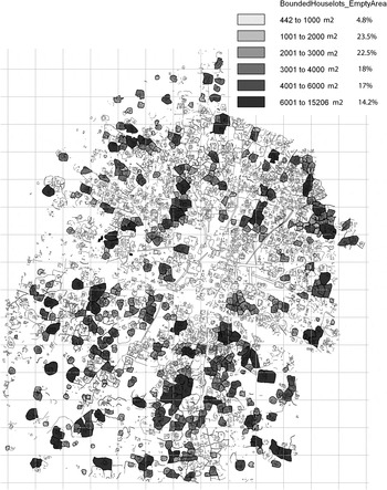
To calculate the empty area of each bounded houselot, we first calculated the total area covered by architectureFootnote 7 and then we subtracted this value from the total area of the bounded houselot (Table 3). The size of the empty area ranges from 442 m2 to 15,206 m2 with an average of 3,595 m2 (Table 3; Figure 9; Appendix 1). The distribution of empty areas in houselots across the site does not correlate with distance from the site center (Pearson's r = 0.060, p = 0.235). This shows that less prosperous households with small houselot areas and limited architecture could have been located close or far away from the site center.
Map of the 392 bounded houselots showing the distribution by size of empty area. (Grid squares are 250 × 250 m.)

Finally, we calculated the total volume of all the architecture in each bounded houselot. Volume of architecture has often been used to reflect the scale of power and control of labor and resources that a particular group could command (Abrams Reference Abrams1994; Arnold and Ford Reference Arnold and Ford1980). Here it would reflect the labor and resource control that each household in the bounded houselots had. We expect volume of architecture to be a better predictor of household wealth, than simply measuring area covered by architecture, which may be the result of spatial constraints, rather than economic considerations. Volume of masonry architecture, however, does not take into account perishable structures that may have been present in a houselot. As a result, the cost of construction may be underestimated. This may have been the case when only basal platforms and no masonry superstructures or foundation braces for superstructures were present; but these were not common at Chunchucmil at this time. We should also keep in mind that large volume of architecture may be the result of small sequential increases in construction over several generations of each houselot's inhabitants, thus volume of architecture may reflect the length of occupation of the houselot and not solely the wealth and control of resources on the part of household members (Hendon Reference Hendon1992). Excavations in the buildings of these houselots would help with understanding the exact length of occupation at each residential group, but it is unfeasible to excavate structures in all 392 bounded houselots. Thus, without excavations the volume of architecture represents the amount of architecture present in the final occupational phase of the houselot, independent of length of occupation. At Chunchucmil the presence of networks of boundary walls and streets integrating all residential groups indicates contemporaneity of occupation at one point in time. The ceramics recovered in the 115 sampled residential groups indicate that all these groups were occupied during the same ceramic phase of the late Early Classic and early Late Classic periods, but it does not necessarily imply that all residential groups had the same length of occupation. In fact, our extensive excavations in some of these domestic groups have revealed that neighboring groups were occupied for different lengths of time. Finally, we should remember that access to goods is another important measure of group prosperity (Smith Reference Smith1987). In fact, even small residential groups with humble architecture may have had an abundance of precious portable goods, such as the valuable burial offerings found in the architecturally modest eastern shrine of the ‘Aak Group (Hutson Reference Hutson2010). Although these caveats mean that volume of architecture is not an exact indicator of group prosperity, we move forward with the tentative hypothesis that volume of architecture may still be a rough proxy for prosperity.
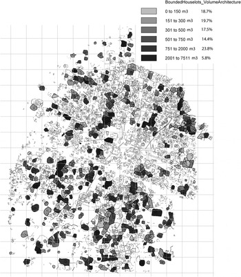
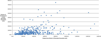
The volume of architecture inside the 392 bounded houselots ranges from no volumeFootnote 8 to 7,510 m3 with an average of 740 m3 (Table 3; Figure 10; Appendix 1). The volume of architecture inside the bounded houselots strongly correlates with the empty area of the houselot (Pearson's r = 0.427, p = 0.0001) (Hutson et al. Reference Hutson, Magnoni, Mazeau, Stanton, Mathews and Morrison2006) (Figure 11), as well as with the total architectural area (Pearson's r = 0.845, p = 0.0001). Since the size of the empty area of the houselot may represent group prosperity in terms of land available for gardening, craft activities, and feasting (Arnold Reference Arnold1990; Killion Reference Killion1990, Reference Killion and Killion1992; Robin Reference Robin2002), and the volume of architecture may reflect labor investments and control of resources on the part of the household (Abrams Reference Abrams1994; Arnold and Ford Reference Arnold and Ford1980), residential groups with large volumes of architecture and extensive garden areas can be considered wealthier and more affluent than those with small volume of architecture and limited garden areas. A similar pattern was encountered at Sayil where large architectural groups controlled larger fertilized gardens areas (Smyth et al. Reference Smyth, Dore and Dunning1995).
Map of the 392 bounded houselots showing the distribution by volume of architecture. (Grid squares are 250 × 250 m.)

Scatter plot of volume of architecture and empty area of the sample of 392 completely bounded houselots.

No correlation between volume of architecture inside the houselots and distance from the site center (Pearson's r = −0.003, p = 0.955) was found at Chunchucmil, indicating that the houselots of different economic status were equally distributed throughout the site (see also Hutson et al. Reference Hutson, Magnoni, Mazeau, Stanton, Mathews and Morrison2006). Stated differently, more prosperous residences with a large volume of architecture and extensive garden areas were dispersed throughout the site, as opposed to being clustered in the site center. This was also suggested by the lack of correlation between the empty area of bounded houselots and the distance from the site center. Our findings resemble those from Tikal, where Arnold and Ford (Reference Arnold and Ford1980; Reference Arnold and Ford1982) found no correlation between labor investments as an indicator of status of a residential group and proximity to the site center (Folan et al. Reference Folan, Kintz, Fletcher and Hyde1982; Haviland Reference Haviland1982). The dispersion of houselots of different status and wealth throughout the Chunchucmil urban area may be an indication that people move to the city rapidly without concern for location (Arnold and Ford Reference Arnold and Ford1980). On the other hand, other researchers have found positive correlations between vaulted buildings, which required considerable labor expenditure and are considered elite buildings, and distance from the site center at sites like Coba and Dzibilchaltun (Fletcher and Kintz Reference Fletcher, Kintz, Folan, Kintz and Fletcher1983; Folan et al. Reference Folan, Hernandez, Kintz, Fletcher, Heredia, Hau and Canche2009; Folan et al. Reference Folan, Kintz, Fletcher and Hyde1982; Kurjack Reference Kurjack1974). Recent analysis of the Coba settlement (Folan et al. Reference Folan, Hernandez, Kintz, Fletcher, Heredia, Hau and Canche2009) has provided a more sophisticated understanding of the distribution of architectural groups at this site, confirming the concentric model with a concentration of elite architectural complexes close to the site (Fletcher and Kintz Reference Fletcher, Kintz, Folan, Kintz and Fletcher1983; Folan et al. Reference Folan, Kintz, Fletcher and Hyde1982), but also showing that some elite compounds were located close to sacbe termini at considerable distances from the site center. At Chunchucmil a few sacbes extending into the residential core away from the site center were connected to architectural groups of substantial size and volume, but this pattern accounts only for a few of the large volume architectural groups present throughout the urban settlement.
Vaulted Architecture
In 1954, Bullard postulated a correlation between the presence of vaulted architecture, considered an elite dwelling characteristic, and the size of the bounded houselot. At Chunchucmil the number of recorded vaults is small (ca. 55 in the 392 bounded houselots). We suspect that this is the result of Early Classic architectural characteristics, where no diagnostic vault stones (unlike the diagnostic Late-Terminal Classic vault stones) can be singled out in the collapsed rubble of architecture. Vegetation cover and the inexperienced eyes of some members of our mapping team may also lead to the underrepresentation of vaults in our sample. Given the small number of recorded vaulted buildings and the possibility of not having a representative sample, we decided not to pursue the hypothesized correlation between vaulted architecture and houselot size. On the other hand, Fletcher and Kintz (Reference Fletcher, Kintz, Folan, Kintz and Fletcher1983) tested Bullard's hypothesis at Late Classic Coba and found a statistically significant correlation between the presence of vaulted architecture and the size of the houselots, as well as a larger number of vaulted elite buildings (in bounded and nonbounded houselots) close to the site center. At predominantly Late Classic Dzbilchaltun, Kurjack (Reference Kurjack1974) found that vaulted structures were concentrated in the central part of the site and decreased with distance from the site center. In both cases, the main occupation of Dzibilchaltun and Coba dates to the Late Classic period, where vaults would have more diagnostic architectural elements (such as “boot shaped stones”) and thus more easily recognized by archaeologists during mapping efforts.
URBAN EXPERIENCE AT CHUNCHUCMIL
Chunchucmil's settlement pattern has two distinctive characteristics: a very high population density and an abundance of houselots bounded by stone walls. Such domestic boundary walls contributed to the stabilization of specific identities for each houselot, resulting in a highly fragmented social mosaic. Yet the high population density and other factors facilitated bonds across these houselots, producing a strongly woven social fabric. In this section, we begin by discussing the creation of houselot identities and then examine the processes that crosscut these houselots and made Chunchucmil a socially liveable place.
The basic characteristics of Chunchucmil's residential groups—the arrangement of structures around a common patio (Ashmore Reference Ashmore and Ashmore1981; Becker Reference Becker1999)—were similar to many other sites in the Maya region. Nearly all of Chunchucmil's houselots, however, were bounded by stone boundary walls, albarradas, and short and narrow winding causeways, chichbes. In addition, in the dense residential core, where all houselots share boundary walls with at least one neighbor, space was often left between parallel walls to create streets that allowed traffic to flow. No other Classic period site had such a dense settlement and such an extensive network of boundary walls and streets. Only a few Postclassic sites in the northern lowlands, like Mayapan (Bullard Reference Bullard1952, Reference Bullard1954; Smith Reference Smith1962) and on the East Coast (Benavides Castillo Reference Benavides Castillo1981; Sierra Sosa Reference Sierra Sosa1994; Vargas et al. Reference Vargas, Santillan and Vilalta1985) show a somewhat similar network of boundary walls enclosing residential groups. In these later sites, the enclosed residential groups were generally smaller, and streets were not as ubiquitous.
At Chunchucmil the majority of residential groups consisted of the residences of two to three families, a few auxiliary structures, and an eastern shrine for domestic rituals (present in almost two-thirds of the houselots) arranged around one or more common patios. An empty area—solar—(average of ca. 3,600 m2) was part of the enclosed houselot and could have been used for intensive and extensive gardening, as well as a variety of other activities, such as crafting, food processing, and washing clothes. Variations in the number of residences and area enclosed by boundary walls suggest that the number of families belonging to a household varied considerably (from one to possibly as many as 10 or more families in a few cases), but we know from our extensive excavations in some of these residential groups that these houselots were all equivalent social units, where production, distribution, transmission, and reproduction were carried out jointly by the household members (Wilk and Ashmore Reference Wilk and Ashmore1988; Wilk and Rathje Reference Wilk and Rathje1982).
Each residential group had a specific identity that was developed through time by the continuous relations of its members. We believe that these houselot identities share some characteristics with the maisons discussed by Claude Lévi-Strauss (Hutson et al. Reference Hutson, Magnoni and Stanton2004). The daily practices and habitual activities that household members regularly carried out in the material setting of the houselot would have shaped a shared identity and a common social memory (Connerton Reference Connerton1989; Hutson Reference Hutson2010; Hutson et al. Reference Hutson, Magnoni and Stanton2004; Magnoni Reference Magnoni2008). While in other publications (Hutson Reference Hutson2010; Hutson et al. Reference Hutson, Magnoni and Stanton2004; Magnoni Reference Magnoni2008) we have reported on a wide variety of domestic practices documented in the extensively excavated groups, here we want to focus on just two aspects of houselots: boundary walls and shrines. Both of these served to reinforce distinct house identities at each of the houselots. The delimitation of the domestic area by a boundary wall demarcated the specific space belonging to one household in which daily practices would have been shared jointly by household members. While albarradas may have had some practical use (e.g., keeping domestic animals inside houselots, removal of rocks to make more soil available for planting), the ubiquity of the boundary walls throughout Chunchucmil is unlike any other Classic period site. The density of settlement may have provided the impetus behind the erection of these walls in an effort to mark boundaries and keep nonhousehold members off residential grounds, but in doing so the walls also helped delineate the common living area where individual household identities were forged by constant interactions and daily practices. Constructed space is socially produced, but in turn the resulting materiality of the built environment provides an active medium in which social life takes place (Bourdieu Reference Bourdieu1977; de Certeau Reference de Certeau and Rendall1984; Giddens Reference Giddens1979, Reference Giddens1984; Pred Reference Pred1990; Soja Reference Soja1989, Reference Soja1996, Reference Soja2000; Tringham Reference Tringham, Gero and Conkey1991, Reference Tringham, Benjamin, Stea and Arén1995). People's daily practices are enabled and constrained by the physical aspects of the material world, but at the same time these habitual social actions are also constantly molding the surrounding landscape in a process that Keith Basso (Reference Basso, Feld and Basso1996:55) has called “interanimation.” The need and desire to keep people out of one's residential area created a defined space for increased interaction among household members, which would have also strengthened a common identity (Hutson Reference Hutson2010; Hutson et al. Reference Hutson, Magnoni and Stanton2004; Magnoni Reference Magnoni2008).
Another material aspect that contributed to the forging of the household identity was the presence of an eastern shrine in which household members would have participated in common domestic ritual activities. All of the domestic shrines that we have excavated exhibit glaring architectural differences; each shrine is blatantly unique. The architectural aspects of each domestic shrine, and sometimes of the whole residential group, were interpreted as attempts by each group to diacritically mark themselves as different from the others while strengthening ties within the group. The occurrence of domestic shrines in as many as two-thirds of the houselots at Chunchucmil stands in sharp contrast to other Maya sites, where eastern shrines were not as common (for instance, only 14% of residential groups at Tikal show an eastern shrine, Becker Reference Becker1999). We interpret the presence of domestic shrines as an expression of social coherence as well as an attempt on the part of household members to provide an arena for the reinforcement social bonds, but also for negotiating internal power relations (Hutson et al. Reference Hutson, Magnoni and Stanton2004). The majority of houselots with an eastern shrine at Chunchucmil also had their buildings aligned at right angles and shared a common platform, two measures that are considered to reflect the degree of household social integration and cohesion (Wilk Reference Wilk1983, Reference Wilk, Netting, Wilk and Arnould1984).
Through storing ancestors' bones, heirlooms, and other valuable offerings in these buildings, participating in ritual experiences, carrying out feasting events and sacrifices (Hutson Reference Hutson2010; Magnoni Reference Magnoni2008), residents of these bounded houselots would have shared a set of common practices. The continuous architectural modifications that these domestic shrines underwent, revealed by the extensive excavations in four of these houselots, also indicate the constant power negotiations among household members through time (Hutson Reference Hutson2010; Hutson et al. Reference Hutson, Magnoni and Stanton2004; Magnoni Reference Magnoni2008). In addition, these shrines played an essential role in the process of creation and maintenance of social memory for the group. The burial of objects and ancestors inside these buildings not only represented the transformation of these structures into sacred places, but also marked the permanent inscription of these items and individuals into the domestic landscape (Connerton Reference Connerton1989; Hendon Reference Hendon2010). The knowledge of the location of these caches and burials together with their associated histories and memories were passed down from generation to generation as shown by the re-accessing of some of these sealed deposits, in a process that would have contributed to create and maintain a social memory and to strengthen a shared identity.
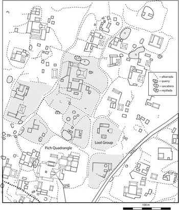
Although each residential group maintained a distinct house identity, many other processes caused these distinctions to blur. For example, in building their residential groups, Chunchucmileños repeated the same basic layout, which followed a similar architectural grammar with structures, including an eastern shrine, arranged around a common patio (see also Becker Reference Becker and Sabloff2003). This layout was then repeated at different scales from small to large, reaching up to the largest architectural groups at the site, the quadrangles (Magnoni et al. Reference Magnoni, Ardren, Hutson, Dahlin, Fisher and Creekmore2013) (Figure 12). These quadrangles share the basic arrangement of smaller houselots: an eastern temple—a larger version of the domestic shrine—sharing a common patio with range structures on the other three sides. These quadrangles, eleven of which were in the site center and five of which were at varying distances from the site center, were the most impressive architectural groups at the site. No large acropolis groups, palaces, plazas, or monumental architectures were present at Chunchucmil. While we have suggested elsewhere that the reduplication of several large architectural groups of similar form and size in the site center indicates a political organization shared by multiple power holders during the Early Classic period (Dahlin Reference Dahlin2003; Magnoni et al. Reference Magnoni, Hutson, Stanton, Stanton and Magnoni2008), here we want to emphasize that ruling elites were elaborating their identities in similar material settings as smaller households. In many cases quadrangles were also partially or completely enclosed by boundary walls, unlike at Coba or Mayapan where boundary walls were not present around public civic architecture (Bullard Reference Bullard1954; Fletcher Reference Fletcher, Folan, Kintz and Fletcher1983a). Elite residents of quadrangles at Chunchucmil were thus using similar material aspects to demarcate and define their residential quarters as commoners' houselots.
Portion of Chunchucmil map showing residential groups of different sizes next to each other, including one of the smallest quadrangles, Pich quadrangle. Completely bounded houselots that were part of the sample used in this study are shaded in gray.

Another important aspect that reinforced social bonds across houselots was a lack of segregation of domestic units based on wealth; instead residents of different status were living next to each other. As we illustrated above, at Chunchucmil residential groups of different sizes were located next to each other (Figures 9–10, 12). Large groups, measured in terms of number of structures, area covered by architecture, size of the empty area, and volume of architecture, were dispersed throughout the site and not concentrated in the site center, as was instead the case in other Maya sites (e.g., Fletcher and Kintz Reference Fletcher, Kintz, Folan, Kintz and Fletcher1983; Folan et al. Reference Folan, Kintz, Fletcher and Hyde1982, Reference Folan, Hernandez, Kintz, Fletcher, Heredia, Hau and Canche2009; Kurjack Reference Kurjack1974). In addition, the density of settlement and the shared network of boundary walls and streets fostered increased social interactions between neighboring residents independent of their socioeconomic status (Hutson and Magnoni Reference Hutson, Magnoni and Gallegos2011). The narrow streets were the only way to get from place to place, thus forcing face to face interaction among a variety of actors. Chunchucmil's extreme population density intensified interactions among the urban dwellers. We estimate the total population of Chunchucmil to have been between 34,000 and 43,000, packed within 20–25 km2. By sharing fences (never taller than 1–1.5 m) and narrow streets, Chunchucmileños were constantly forced to participate in extra-household interactions, and as a result interdependencies among individuals and households were created and a common urban identity was shaped (Magnoni et al. Reference Magnoni, Ardren, Hutson, Dahlin, Fisher and Creekmore2013). While the materiality of the urban environment, with its boundary walls and narrow streets nestled in an extremely dense layout of residential groups, encouraged extra-household interactions, this built environment was also the outcome of social negotiations and collaborations among neighboring residents. In fact, no centralized planning is visible in the creation of the network of boundary walls and streets.
As we mentioned above, domestic shrines, which were present in all quadrangles and a large majority or residential groups must have been important places for genuine spiritual belief and religious expression at an individual and household level. Yet, the religious practices carried out at these locations may have also helped cement a shared set of beliefs and traditions across households throughout the site. A further set of shared experiences were centered on participation in trading and market activities. The location in a marginal environment, which would have made agricultural self-sufficiency extremely unlikely (Dahlin et al. Reference Dahlin, Beach, Luzzadder-Beach, Hixson, Hutson, Magnoni, Mansell and Mazeau2005), and the proximity to diverse resource-rich ecological areas, such as the coast and savanna, indicate that Chunchucmil residents must have had to rely on a variety of activities besides farming. Our extensive excavations have largely failed to identify workshops or evidence of specific specialized activities, due to lack of preservation of perishable materials, which would have made the bulk of the processed and traded goods at this city (Dahlin et al. Reference Dahlin, Bastamow, Beach, Hruby, Hutson, Mazeau, Hruby, Braswell and Chinchilla2009). In one residential group evidence for processing of agave fibers has been inferred by the use wear on a large number of prismatic obsidian blades (Hutson Reference Hutson2010). In other houselots large numbers of metates suggest specialized production beyond household needs (Magnoni Reference Magnoni2008). The short distance to the coast and the salt flats, which were the second largest of Mesoamerica during the Postclassic period, suggests that Chunchucmil may have functioned as a major redistribution center for salt and other Mesoamerican goods traded along the coast (Dahlin et al. Reference Dahlin, Andrews, Beach, Bezanilla, Farrell, Luzzadder-Beach and McCormick1998). In addition, with large numbers of visiting traders, Chunchucmil residents must have provided a host of provisioning services.
The widespread circulation of obsidian, which preserves well in the archaeological record, illustrates that all Chunchucmileños extensively participated in a trading and market economy. The abundant and equal distribution of El Chayal obsidian (97% of Chunchucmil obsidian comes from El Chayal) across houselots of different size and socioeconomic status, as indicated by size of empty areas and volume of architecture, clearly indicates that a market economy and not a redistributive economy was operating at this large urban center (Hutson and Dahlin Reference Hutson and Dahlin2008; Hutson et al. Reference Hutson, Dahlin, Mazeau and Marshall2010). Through configurational data and soil chemistry, Dahlin (Reference Dahlin2003; Dahlin et al. Reference Dahlin, Jensen, Terry, Wright and Beach2007) has interpreted a flat, leveled 1-ha area bounded by the three major sacbes in the site center as a marketplace. The widespread and egalitarian distribution of obsidian prismatic blades reveals that most city dwellers actively participated in a market economy that provided ample access to an exotic good. The habitual interactions and transactions at the marketplace, the regular participation in long-distance trade, and the frequent involvement with visitors and foreigners would have generated a set of shared experiences that reinforced social bonds across different houselots. These experiences together with the common experiences of sharing an urban built environment densely packed by similar social units would have shaped a sense of what it meant to be a Cunchucmileño.
CONCLUSION
In this paper we have illustrated the distinctive settlement patterns of the city of Chunchucmil during its largest occupation in the middle of the Classic period (a.d. 400–650). The unusually dense urban settlement showcased a network of boundary walls and chichbes surrounding residential groups and narrow streets winding between the tightly bounded houselots. We reviewed the basic characteristics and the structural composition and variability of late Early Classic and early Late Classic residential groups, using a sample of 392 completely and unambiguously bounded houselots. Then we explored how these city dwellers may have experienced their urban environment. The focus here is on understanding how the material aspects of the socially constructed space affected people's practices.
We suggest that the materiality of the houselot, particularly the delimitation of the habitational area by a boundary wall or a chichbeh, which clearly demarcated the common space for the daily practices and interactions of household members, would have helped the creation and maintenance of individual household identities and social memories. In addition, we argue that the presence of a domestic shrine in two thirds of the houselots with buildings aligned at right angles and often sharing a common platform were indications of strongly integrated households. Domestic shrines with ancestor burials, dedicatory offerings, and heirlooms were the focus of household rituals, which would have cemented a household identity and shaped social memories.
At the same time, different aspects of the urban built environment would have facilitated built social bonds across Chunchucmil's houselots. The common architectural grammar in small and large architectural groups alike suggests the presence of a template from the smallest houselots to the large quadrangles, the elite architectural complexes. Moreover, the distribution of houselots with empty areas of different sizes and varying amounts of architectural volume throughout the settlement independent of distance from the site center indicates that people lived next to neighbors of different wealth and status. The lack of segregation of houselots by size and wealth implies that neighbors of different status would have participated in extra-household activities by co-inhabiting the urban landscape. In fact, the material aspects of the urban settlement, with shared boundary walls and narrow streets, would have encouraged interaction and communication among residents. Common participation in exchange at large markets in the center of the city provided further contacts that crosscut the highly atomistic domestic arrangements. All of these shared experiences helped mitigate the fragmentation inherent in the hundreds of distinct household identities. In other words such a balance between house-based and civic-based experiences made urban living possible.
RESUMEN
En este artículo ilustramos el singular patrón de asentamiento de la ciudad de Chunchucmil durante su mayor ocupación a mediados del periodo clásico (400–650 a.C.). El asentamiento urbano, insólitamente denso, muestra una red de albarradas y chichbes que rodean grupos residenciales y angostas callejuelas que serpentean entre estas unidades habitacionales. Usando una muestra de 392 unidades habitacionales que estaban encerradas completamente y de modo inequívoco por albarradas, presentamos las características, la composición y la variabilidad estructural de los grupos residenciales de la segunda faceta del clásico temprano y la primera faceta del clásico tardío. Además, intentamos reconstruir la experiencia de los habitantes de Chunchucmil en este ambiente urbano. Nos enfocamos en entender como los aspectos materiales del espacio socialmente construido afectaron las prácticas diarias. Proponemos que la materialidad del conjunto doméstico, en particular la delimitación del espacio habitacional por una albarrada o chichbeh, que claramente delineaban el área común donde se llevaban a cabo las actividades y las interacciones diarias de los residentes, ayudaron a crear y mantener una identidad y memoria social a nivel de grupo doméstico. Además, la presencia de un templo doméstico en casi dos tercios de los grupos residenciales, con edificios alineados a ángulos rectos y en muchos casos compartiendo una plataforma común, indican que estas unidades domésticas eran socialmente muy integradas. Estos templos domésticos con los entierros de ancestros, ofrendas y reliquias fueron el centro de rituales domésticos que reforzaron una identidad doméstica y crearon una memoria social compartida. Al mismo tiempo, varios aspectos del espacio urbano construido facilitaron la creación de lazos sociales compartidos entre los residentes de Chunchucmil. La gramática arquitectural de estructuras dispuestas alrededor de un patio común y con un templo doméstico al este del patio común fue compartida por grupos residenciales grandes y pequeños. La distribución a través del sitio de unidades habitacionales de diferentes tamaños y con cantidades variables de volumen arquitectónico independientemente de la distancia del centro del sitio, indica que habitantes de diferentes rangos económicos y sociales fueron vecinos y compartieron albarradas. Por otra parte, los aspectos materiales del ambiente urbano, como las angostas callejuelas y el denso asentamiento con albarradas compartidas, fomentaron la interacción y comunicación entre grupos domésticos de rangos y estatus diferentes y por eso facilitaron la creación de vínculos sociales compartidos. Las actividades comerciales llevadas a cabo en el mercado y la participación en el intercambio de larga distancia también sirvieron a reforzar los lazos sociales entre los ciudadanos. Todas estas experiencias compartidas por los Chunchucmileños sirvieron a mitigar la fuerza centrífuga de las identidades domésticas, que pudieron haber funcionado en contra de la solidificación de una identidad urbana compartida.
ACKNOWLEDGMENTS
First, we want to acknowledge the passing of Bruce Dahlin during the preparation of this manuscript. Bruce started the Pakbeh Regional Economy Project in 1993 and, with Traci Ardren (1998–2002) and Scott Hutson (2004–2006) as codirectors, continued to direct the project until fieldwork ceased in 2006. His passionate interest in the peculiar aspects of Chunchucmil's settlement together with his enthusiastic dedication to unraveling the distinctive characteristics of the political economy of this city have allowed us to gain a comprehensive understanding of this significant urban center in the Maya region. Bruce always fostered a collaborative, interdisciplinary, and supportive research environment, and for that we are deeply indebted to him.
We thank all the Pakbeh Regional Economy Project members for all the help throughout the years, as well as the people from the villages of Chunchucmil, Kochol, San Mateo, Cohauila, and Halacho, without whose help this research could have not been carried out. Special gratitude goes to Instituto Nacional de Antropología e Historia and the Consejo de Arqueología for giving us the permission to work at Chunchucmil. We want to acknowledge the support and patience that Alejandra Alonso and Traci Ardren showed during the preparation of this manuscript, and we are grateful for the comments and suggestions of William Folan and two anonymous reviewers. All errors and omissions are those of the authors exclusively. Support for the research discussed in this paper has come from the National Geographic Society and the National Science Foundation. Special thanks to Scott Sorokoski at Integraph for all the invaluable technical support with GeoMedia.
Portions of this paper were presented at an SAA session to honor E. Wyllys Andrews V in April 2010. We want to acknowledge the support and encouragement that E. Wyllys Andrews V has given us to carry out research at Chunchucmil. He was one of few scholars to understand the significance of this site before it finally made it onto maps of the Maya region. Aline Magnoni, a student of Will's, is particularly grateful for the constant guidance and precious advice throughout the years at Tulane and beyond; the invaluable mentorship is unrivaled.
List of the 392 completely bounded houselots with all the variables discussed in the text (all measurements are in m, m2 and m3).