

Regional differences in industrial development have always interested economic historians. One familiar example in nineteenth-century U.S. economic history is the contrast between the rapid adoption of mineral fuel at blast furnaces in eastern Pennsylvania and the much slower development of mineral-fuel furnaces in western Pennsylvania. Scholars have provided various explanations for the perceived lag.1
Hunter, “Influence”; Temin, Iron; Warren, American Steel Industry; Walsh, Diffusion; and Allen, “Peculiar Productivity.”
Evans and Rydén, “Industrial Revolution,” pp. 2–7.
We agree that regional differences require explanation, but we find previous characterizations and explanations of the antebellum iron industry flawed in important ways. First, the anthracite iron region in southeastern Pennsylvania was a singular exception to the pattern of technology transfer and modernization in the antebellum industry. Measuring other regions against the anomalous one has skewed historical understanding of what was a highly experimental period of industrial development. Second, many of the conclusions drawn in earlier studies were based on limited price series, aggregate production data, or anecdotal evidence. Our more systematic evidence corrects a number of errors in those studies and for the first time explicitly reveals the geography of antebellum pig iron markets and the connections between rolling mills and their various sources of iron. We will focus in particular on disproving the argument that anthracite iron put western charcoal-iron producers out of business.
Our over-arching argument is that to understand differences in regional economic development, one must consider economic change in the context of regional conditions, including geographical conditions. Our method involves the use of a geographic information system (GIS), or geospatial database, to analyze spatial and temporal patterns in the industry's development and to examine those patterns in relation to the development of Pennsylvania's transport infrastructure.3
For a general introduction to GIS see Longley et al., Geographic Information Systems. On historical GIS, see Knowles, ed., Emerging Trends; Past Time; and Spatial Turn; Healey and Stamp, “Historical GIS”; Gregory, Place; and Ell and Gregory, eds., History.
Lesley's geographical descriptions vary considerably in quality and detail. We checked each of his locational descriptions for ironworks in Pennsylvania against U.S. Geological Survey topographic quadrangles (scale 1:24,000) using the Survey's online Geographic Names Information System (http://geonames.usgs.gov) and the linked website TopoZone.com, which provides latitude and longitude coordinates interactively. Where a given ironworks' location was not immediately apparent on the USGS map (as was often the case), we resorted to additional maps and other sources to narrow down the possibilities. The dataset includes estimates of the locational accuracy of our point placements and of Lesley's information. Generally, his descriptions proved remarkably accurate, even in remote areas.
Rich as Lesley's information is, it is far from complete. Perhaps the most serious omissions are the lack of construction dates for more than half of all blast furnaces and of abandonment dates for over 60 percent. We substantially enhanced Lesley's data by consulting county and local histories, historical maps, American Iron and Steel Association reports, company papers, the U.S. manufacturing census, and other sources.5
Upon publication of her book on the iron industry, tentatively titled Hard as Iron: Geography, Labor, and Technology in the Struggle to Modernize America's Iron Industry, Knowles will provide a full explanation of the Lesley historical GIS (hereafter, Lesley HGIS) and a bibliography of its approximately 50 sources on her website at http://www.middlebury.edu/academics/ump/majors/geog/hours/aknowles.htm.
Previous maps of Lesley's data appeared in Paullin, Atlas, plate 135; Warren, American Steel, figures 1.1–1.6; and Williams, Americans and Their Forests, pp. 149, 151.
For the period 1860–1875, we drew on information contained in Annual Reports and Board of Managers Minutes of the Pennsylvania Railroad and Pennsylvania Bureau of Industrial Statistics reports. Our representations of Pennsylvania transport infrastructure were derived from the maps and tables in Baer, Canals.
During the antebellum period, Pennsylvania's developing economy was characterized by a dispersed and imperfectly known resource endowment, limited transportation infrastructure, large areas of difficult terrain, significant topographic barriers, and limited capital for investment in new industry. Direct transportation links between eastern and western parts of the state across the Appalachian divide were of very limited capacity. Economic factors vary, however, in the extent to which they are affected by the “friction of distance.” Business confidence and willingness to lend were fairly efficiently communicated between business centers across the eastern United States and even internationally in this period. New industrial technologies required skilled personnel for implementation, and these individuals were sometimes in short supply, but ironmasters throughout the country were aware of the skills required for modern iron making. Market competition, on the other hand, requires more than good information. The combination of freight rates and price differentials must be sufficiently favorable to make delivered goods competitive in distant markets. The quality of those goods must also appeal to distant buyers, a matter of preference and judgment strongly influenced by producers' reputation.
Taking these conditions as background to our investigation, we will examine the following sets of related hypotheses:
First, ironmasters across Pennsylvania attempted to adopt mineral-fuel technologies at more or less the same time. The length of time it took them to achieve sustained, profitable production, however, varied significantly, due in large part to the geographical conditions of each region.
Second, investment and disinvestment in iron ventures tended to follow national business cycles closely. The impact of tariff policy weakened with distance from the Atlantic coast. Within a given region, ironworks with relatively poor access to transportation were more vulnerable to economic downturns.
Third, price convergence did not necessarily indicate market penetration or the economic integration of geographic regions. Quality considerations prevented the free substitution of mineral-fuel iron for charcoal iron. As transportation networks expanded and improved and transport costs dropped, regional markets became more porous and long-distance shipments more competitive, but the friction of distance remained a significant cost factor throughout the period.
Fourth, iron markets were regionally segmented along the dividing lines of major topographic barriers. In Pennsylvania, this was manifest in the emergence of two distinct market regions, one in the east focused on Philadelphia, another in the west focused on Pittsburgh. Segmentation, however, was not rigid, nor was integration swift. Markets were dynamic regions whose extent and permeability changed in response to many factors.
ADOPTION OF BRITISH METHODS OF IRON-MAKING
Peter Temin summarized the prevailing view of western regions' backwardness in iron making when he wrote, “technological advances hinging on the use of mineral fuel in the blast furnace were largely ignored before the Civil War west of the Allegheny Mountains where half the iron industry was concentrated.”7
Temin, Iron, p. 7.
Lesley, Guide; and Evans and Rydén, eds., Industrial Revolution.
Some U.S. blast furnaces mixed charcoal with mineral fuel, and most new furnaces after 1840 used steam power to run hot-blast blower engines, a fuel-saving innovation developed for coke furnaces by the Scot James Beaumont Neilson in 1828.9
Warren, Wealth, p. 3.
Lesley, Guide; Cooper, Hewitt & Company Papers; Galer et al., Ames Iron Works, pp. 104–05; and Rydén, “Responses.”
Ordnance Survey, “Merthyr Tydfil.”
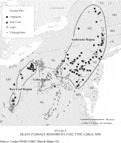
Within the blast furnace sector, the anthracite iron district of eastern Pennsylvania stands out as the only American iron region where British smelting technologies were quickly adopted in toto and mineral-fuel furnaces rapidly achieved levels of production matching British furnace output (see Figure 1). Trans-Atlantic technology transfer was unusually quick and complete in this case because all necessary factors of production were present in eastern Pennsylvania or were swiftly transplanted there. The region's anthracite coal mines began production on a substantial scale in the 1820s.12
Yearley, Enterprise; and Knies, Coal.
Shaefer, “Official … Map”; Healey, Pennsylvania Anthracite; Baer, Canals; Warren, American Steel, pp. 18–19; and Lesley, Guide.
Knowles, “Labor”; Lehigh Crane Iron Company Papers; and U.S. Population Census, 1840, 1850, 1860.

FIGURE 1 BLAST FURNACE REGIONS BY FUEL TYPE, CIRCA 1858
Conditions in western Pennsylvania were not so favorable. The region's thin population and rugged topography made transportation improvements less compelling and more costly than in the east. The Main Line Canal from Philadelphia did not reach Pittsburgh until 1833, and the Pennsylvania Railroad did not provide through connections on good track until 1852.15
Baer, Canals; and Schotter, Growth, p. 35.
Lycoming Coal Company Collection; George's Creek Journal; and Lesley, Guide.
They did, however, encounter serious problems in attaining sustained, profitable production of iron. Eager investors such as the Boston capitalists behind Farrandsville Furnace sank tens and even hundreds of thousands of dollars into ironworks before the quality of their property's coal and iron ore was fully assayed, only to discover later that, for example, their bituminous coal had too much sulfur to make good iron. Furnaces built in advance of railroads and canals relied on spring freshets to get much of their iron to market, often a risky business. Frontier furnaces also faced more daunting labor problems than did iron towns closer to the coast. It was sometimes difficult to convince skilled miners and furnace hands to migrate inland, and it was more difficult to maintain a full workforce as ethnic conflicts, disagreements with American managers, bad weather, boredom, and desertion for better-paying work elsewhere thinned the ranks.17
Knowles, “‘white hands’”; George's Creek Journal; and Lycoming Coal Company Collection.
Despite the obvious economic benefits of the British model of iron-making, it was not practical or economically feasible to transplant it in its entirety to most American iron regions. Technological change came as quickly to western as to eastern Pennsylvania, but industrial take-off took longer, in large part because of geographical factors.
CYCLES OF INVESTMENT AND DISINVESTMENT
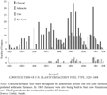
The virtually simultaneous efforts to adopt British mineral-fuel technologies across Pennsylvania suggest that investment in new furnaces and new technologies was driven by broad economic forces. Figure 2 reinforces this impression. In the United States as a whole, construction of every kind of blast furnace increased during periods of national economic growth and fell off sharply in the wake of economic down-turns. The graph shows a collapse after the panic of 1837, followed by a boom in the mid 1840s (when furnace construction surged in both eastern and western Pennsylvania), and the rise of investor confidence again after the difficulties of 1847–1850. The graph also shows that the iron industry was a bellwether for the depression that hit the country in 1857, as investment in new furnaces peaked in 1854 and then dropped precipitously from 1855 through the rest of the decade.

FIGURE 2 CONSTRUCTION OF U.S. BLAST FURNACES BY FUEL TYPE, 1820–1858
Regional and sectoral patterns show some marked divergence from national trends, however. Construction was least cyclical in the South, as charcoal furnaces were built almost every year in Kentucky, Tennessee, and Virginia and only western Tennessee experienced a building boom, in the 1840s. In Pennsylvania, charcoal furnace construction peaked in the 1840s but few were built after 1850, when investment shifted to anthracite furnaces in the east and, to a lesser extent, raw-coal and coke furnaces in the west. The Hanging Rock iron district of southern Ohio grew slowly until the mid-1850s, when railroad construction spurred sudden expansion in the charcoal and raw-coal sectors.18
Mould, Dividing Lines, p. 174.
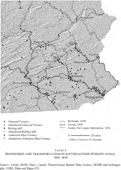
Figures 3 and 4 summarize industrial and transportation development in Pennsylvania's anthracite iron and raw-coal iron regions. (For more detailed time-series maps of each region, see this JOURNAL's website at http://journals.cambridge.org/action/displayJournal?jid=JEH.) The state's first railroads and its first major canals were built in the anthracite coal fields and the gentler terrain connecting Philadelphia to its fertile hinterland (see Figure 3). Completion of the Schuylkill Navigation from Philadelphia to Pottsville in 1825 and of the Philadelphia and Reading Railroad in 1842 certainly facilitated the growth of iron manufacturing in the lower Schuylkill Valley, as reflected in the steady construction of rolling mills (six built by 1831, 13 by 1846). In Danville, however, industrial development came significantly later. The town was connected to urban markets by the North Branch Division of the Susquehanna Canal in 1831 but its hoped-for rail connections via the Little Schuylkill and Susquehanna Railroad were not completed until the 1850s. It is thus not surprising that Danville's first rolling mill was not built until 1845. The first anthracite furnace near Danville was built in 1840, but the other six were built between 1844 and 1847.

FIGURE 3 IRONWORKS AND TRANSPORTATION IN SOUTHEASTERN PENNSYLVANIA, 1842–1858

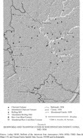
FIGURE 4 IRONWORKS AND TRANSPORTATION IN NORTHWESTERN PENNSYLVANIA, 1842–1858
The timing of Danville's growth spurt shows the salutary effect of changes in national tariff policy on certain sectors of the iron industry. Before 1842, all imported railroad iron had been admitted free of duty. Under the Tariff of 1842, bar iron was subject to duties of $17 per ton and rolled iron to $25 per ton.19
Taussig, Tariff History, pp. 123–26.
Lesley, Guide.
Warren, American Steel, p. 13.
Further inland, rail mills were built before the change in tariff policy (as at Mount Savage in western Maryland, where a rail mill was built in 1839) or in the 1850s. The later surge of blast furnace construction in Ohio suggests that changes in tariff policy had little impact west of the Alleghenies. According to Lesley, only one small mill made rails in the entire Pittsburgh region. Completion of the first canal connecting Pittsburgh to Lake Erie in 1842–1844 may have been a stronger stimulus than the tariff to construction of new ironworks in the region (see Figure 4). Before 1844 only charcoal furnaces were built north of Pittsburgh, all of them located along tributaries of the Allegheny River. Completion of the Erie Extension Canal prompted construction of northwestern Pennsylvania's first mineral-fuel furnaces, as the canal provided access to very good iron ore from outside the region as well as cheap transport of coal and pig iron.
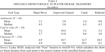
Fairly rapid industrial growth in northwestern Pennsylvania in both backwoods areas and along the Erie Extension canal raises the question of whether distance to improved transportation routes made ironworks more or less vulnerable to economic downturns. Table 1 shows that mineral-fuel furnaces generally were located closer to canals and railroads than were charcoal furnaces.22
The mean and median distances in the table were derived using “Near” analysis in ArcGIS, a function that calculates the shortest linear distance from each point to the nearest feature in the specified feature class—in this case, the shortest distance from each furnace to a major river, channel improvement, canal, or railroad.
In addition to the locating procedure outlined in note 4, we checked the location of blast furnaces in northwestern Pennsylvania against the detailed maps and descriptions in Sharp and Thomas, “Guide.”

The differences in distance to transport make sense. Most mineral-fuel furnaces received fuel or iron ore shipped from mines at some distance from the works, whereas charcoal furnaces had to be located near their source of fuel in woodlands and had to be far enough apart for each to have a ready supply of charcoal. The distance analysis shows much higher mean and median distances from charcoal furnaces to every mode of transport except channel improvements. In one sense the figures are potentially misleading for these furnaces, because almost all charcoal furnaces were located within a short haul of some kind of watercourse. Tributaries of the Allegheny River provided sufficient depth of water most years to float barges carrying pig iron to Pittsburgh.24
Ibid., p. 375.
Bulletin, pp. 88, 97, 99.
Previous studies have argued that antiquated charcoal furnaces quickly lost out in competition to more modern coal-fired furnaces. As Allan Nevins wrote, “‘Tiny ironworks everywhere, but particularly in Pennsylvania, with poor equipment, and an uneconomic force of men, passed rapidly from birth to death; they rose fluttered and fell like May flies.’”26
Nevins, Abram S. Hewitt, p. 102, quoted in Warren, American Steel, p. 11.
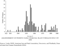
Longevity is difficult to pin down in many cases. Abandonment occasionally was the mistaken interpretation of a furnace being shut down for routine maintenance. Furnaces commonly ceased operating during “dull” years, such as the late 1830s or late 1850s, but resumed when demand revived. The counts in Figure 5 therefore if anything underestimate furnace longevity. They are more reliable than the survival figures for western Pennsylvania furnaces provided in Paskoff, Industrial Evolution, table 25, p. 86, which are based on the small sample of furnaces included in both the 1833 McLane Report and the Ironmasters' Convention Documents of 1850.
Fishlow, American Railroads, pp. 112–18.
Davis, History, pp. 115–21; and Knowles, Calvinists, pp. 176–77, 192–97.

FIGURE 5 ABANDONMENT OF PENNSYLVANIA CHARCOAL BLAST FURNACES BUILT BY 1858
Nevins's image most nearly fits the apparent fate of charcoal furnaces in the Shenango and Allegheny valleys, where 52 percent of furnaces went out of operation by 1858, none of them more than 27 years old. Almost 85 percent of the region's furnaces ran solely on charcoal, and 71 percent of those used cold-blast technology. Almost half of the charcoal furnaces ran on water power alone. Yet not only furnaces using older technologies ceased production. Nearly 70 percent of the region's hot-blast charcoal furnaces ceased production in 1855–1858, compared to 58 percent of cold-blast furnaces. Five of the region's new raw-coal furnaces also shut down in 1854–1855. The general squeeze on credit that began in 1855 and worsened in 1856 may have most hurt newer furnaces burdened with debt from heavy start-up costs.30
Charcoal furnaces built in the Hanging Rock iron district of Ohio in 1854–1855 were among the first to fail as the 1857 Panic took hold. Knowles, Calvinists, p. 177.
Bulletin, 124, 125. See also Davis, History, pp. 115–21; and Williams, Americans, pp. 104–10.
QUALITY AND PRICE
Our third set of hypotheses addresses the relationship between quality, transportation, and the price of iron. Temin argued that the “downward drift of prices” caused by the shipment of anthracite iron to Pittsburgh, which began in 1852, forced western iron masters “to change their production techniques and lower their costs or die, as it were, in the midst of plenty.”32
Temin, Iron, p. 77; and Hunter, “Study,” p. 426.
The best price data available for pig iron sales in Pittsburgh come from newspaper reports that Louis C. Hunter compiled for his study of the city's antebellum iron industry. Those reports show that anthracite iron sold at competitive prices in Pittsburgh but rarely below the price of comparable grades of charcoal iron because of the extra cost of transport.33
Hunter, “Study,” pp. 425–33.
Hunter, “Influence”; Temin, Iron, pp. 54–56; and Gordon, American Iron.
NARA RG 74, Entry 20, Boxes 1–5; and Cooper, Hewitt & Company Papers, letters from Charles Hewitt (14 and 16 April 1847), E. J. Etting & Bro. to A. S. Hewitt (19 November 1847).
At the Trenton Iron Company, a large, modern rolling mill, works managers routinely mixed charcoal iron from eastern furnaces with high-quality anthracite iron from Lehigh Crane. Many iron manufacturers were slower than Trenton to accept anthracite, coke, and raw-coal iron. Before the development of instruments that could scientifically measure the chemical properties of iron, its quality was judged by eye and fairly crude physical tests.36
Cooper, Hewitt & Company Papers; and Gordon, American Iron.
Lesley's data suggest that certain kinds of iron were preferred for specific products. In the late 1850s, imported Swedish, Norwegian, and “Russian” bar was used almost exclusively at rolling mills that made steel. Like the Trenton Iron Works, most rail mills reported a mix of sources, including pig iron, blooms, scrap metal, and raw iron ore from the emerging Lake Champlain and Lake Superior mining districts. Sheet and plate manufacturers preferred blooms and charcoal pig iron. Of the nine rolling mills listed as using anthracite iron, five made nails or spikes, though none of them used anthracite iron exclusively. All but two were east of the Alleghenies.37
Lesley, Guide and Bulletin.
Bulletin, p. 121, citing a letter from John McCrea, 12 January 1857.
In addition to quality preferences, transport costs had a significant impact on iron prices. To estimate transport costs accurately, one needs to know the origin and destination of shipments as well as the means of transport. The geography of supply recorded in the newspaper reports suggests that the lion's share of iron consumed in antebellum Pittsburgh came from charcoal furnaces in the Allegheny Valley and Hanging Rock iron districts. Most Allegheny iron was floated downstream 20 to 100 miles with the spring and autumn freshets on flatboats and rafts at little more than the cost of building the boats. Hanging Rock charcoal iron had to travel nearly as far as Susquehanna Valley anthracite iron, but likely incurred considerably lower transport costs being shipped upstream on steamboats rather than by rail.39
Hunter records several entries of prices for anthracite iron “Delivered on the Susquehanna,” i.e., delivered cost before transportation to Pittsburgh; “Study,” pp. 426, 432, 436, 437. As measured by the GIS, the distance by rail from Harrisburg and by river from Portsmouth, Ohio to Pittsburgh were about the same, roughly 260 miles.
Hunter, “Study,” p. 389; Lycoming Coal Company Collection; Pennsylvania Railroad, Annual Reports, 1851–65. Hunter notes that the contract for 14,000 tons of anthracite iron was “Deliverable on the opening of the Pennsylvania Canal”; “Study,” p. 439.
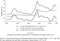
Railroad records permit fairly accurate estimates of transport costs from the anthracite district to Pittsburgh. Figure 6 shows the average cost of producing anthracite iron against the price quoted for No. 1 foundry anthracite pig iron in Philadelphia. Subtracting the latter from the former yields the crude profit margin for iron sold in Philadelphia. If we then further subtract transport costs, we can approximately compare the profitability of selling anthracite iron in Pittsburgh versus Philadelphia—a fair comparison because the commodity's prices in the two markets were similar and moved in tandem.41
Pennsylvania Bureau of Industrial Statistics, Second Annual Report, 1873–4.
Pennsylvania Railroad, Board of Managers Minutes, 6 June 1855; personal communication, Christopher Baer, 18 April 2006. Our figures are comparable to Temin's estimate of $5.00 (his is higher as an estimate for through shipment from Philadelphia) and about half what Hunter noted in his study. Iron, p. 63; “Study,” pp. 430, 436, 437

FIGURE 6 ESTIMATED PROFIT MARGIN OF ANTHRACITE IRON, 1850–1873
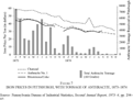
The timing and volume of anthracite iron shipments in relation to charcoal furnace closures suggests that eastern suppliers saw opportunities to establish footholds in the western market when Pittsburgh iron manufacturers lost former sources of supply. The first wave of charcoal furnace closures in western Pennsylvania came in 1849–1851, the second in 1855–1857. The newspaper reports show jumps in anthracite iron sales in 1854 and again in 1857, when an exceptionally large contract for 14,000 tons of anthracite iron was reported.43
Lesley, ed., Iron Manufacturer's Guide; and Hunter, “Study,” pp. 407–33.
Shipments in September of that year were less than 5 percent the amount shipped a year before. Pennsylvania Bureau of Industrial Statistics, Second Annual Report, 1873–4, pp. 294–97, citing American Manufacturer.

FIGURE 7 IRON PRICES IN PITTSBURGH, WITH TONNAGE OF ANTHRACITE, 1873–1874
IRON MARKETS
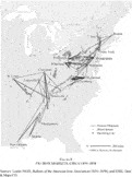
Previous analyses of antebellum iron markets have been based largely on anecdotal reports by contemporary observers or extrapolated from state and county-level figures for aggregate pig iron production and rolling mill output from which authors inferred general trends with little or no concrete evidence about the connections between rolling mills and their sources of supply. By including all of Lesley's data on sources of iron supply in the historical GIS, we have been able to produce the first maps of American antebellum iron markets. Figure 8 shows the destinations beyond the “home market” to which furnace owners, managers, or workers said they shipped pig iron. Lesley reported such destinations for 93 furnaces (12 percent of the total), and for about half of those he named more than one destination. The resulting map significantly under-represents pig iron shipments in this period. Most significantly, it omits shipments of anthracite iron to Pittsburgh and shows no destinations for Hanging Rock iron, which was shipped to Cincinnati, Wheeling, Pittsburgh, and smaller cities in Ohio.45
Hunter, “Study,” pp. 393–433; and Knowles, Calvinists, chapter 4.

FIGURE 8 PIG IRON MARKETS, CIRCA 1854–1858
Despite these limitations, Figure 8 shows some striking patterns that support the hypothesis that antebellum iron markets were regionally segmented along the dividing lines of major topographic barriers. Only two western furnaces reported shipping iron east over the Appalachian divide. Wheeling, connected to the east coast by the National Road, the Chesapeake and Ohio Canal, and the Baltimore and Ohio Railroad, attracted some pig iron from furnaces in eastern Maryland, including anthracite-and-charcoal iron from Baltimore's Elk Ridge Furnace and coke-and-charcoal iron from Antietam Furnace. As a whole, however, pig iron markets in the northeastern half of the United States were regionally delimited. Another strongly focused region was the Great Valley of Virginia, whose charcoal furnaces sent almost all their pig iron to Richmond and Lynchburg. Southwest of Wheeling, a very different geography prevailed. Before the great dams and reservoirs of the twentieth century, Southern rivers were true highways that made long-distance shipment of freight safer and more affordable than shipment on the more steeply graded rivers of New England and the Mid-Atlantic.
The majority of forges and bloomeries met local demand for pots, andirons, farm implements, horseshoes, wheel rims, and nails.46
Lesley uses the terms “forge” and “bloomery” almost interchangeably for some regions, perhaps reflecting local use. Our usage follows the conventional understanding that bloomeries smelted iron from ore in a hearth heated by charcoal whereas forges converted pig iron into wrought iron using charcoal fuel.
Lesley, Guide and Bulletin. Reiser notes that “much of the iron” sent to Pittsburgh in the antebellum period “was transported from forges east of Johnstown.” Pittsburgh's Commercial Development, p. 106.

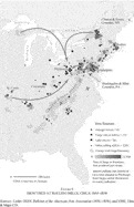
FIGURE 9 IRON USED AT ROLLING MILLS, CIRCA 1854–1858
Figure 9 also maps several other important kinds of iron used at antebellum rolling mills. The triangles mark rolling mills that used foreign iron, mostly bar iron imported from Sweden. Note that all such mills were located on the east coast, with the one inland location (Albany/Troy) within easy reach up the Hudson River. The squares show mills that included a forge for refining pig iron. Like the few companies that built a blast furnace adjacent to their mill in this period, the integration of forge and rolling mill operations marked a stage in the spatial agglomeration of production. The circles on the map indicate rolling mills that used ore from Lake Champlain (Essex or Clinton County) or Lake Superior (Marquette County, Michigan), mainly to line puddling furnaces.48
Technically, ore was not a source of iron but was used as a reagent in puddling furnaces, which Lesley noted as “used in lining” furnaces. See, for example, Bulletin, pp. 149–51.
Seeing the lineaments of pig-iron markets and the contrasting geographies of supply from foreign and domestic forges and emerging iron mining districts raises more questions. Various sources tell us how much iron was produced at blast furnaces, forges, bloomeries, and rolling mills, and Lesley suggests where some of it was used, but even his exceptionally thorough survey does not make the final connection from supply to demand—that is, from iron producers to the foundries and machine shops that manufactured the engines and implements of the industrial revolution.49
Lesley excused himself from including manufacturers in his survey in the April 1857 issue of the Bulletin, p. 73: “Were we to enter upon a summary of these there would be no limit to our tables until we reached the making of needles and watchsprings, and the engrossing of fine wire and sheet iron with wood and other materials in the workshops. It is not the use but the production of iron which we express at present by these statistics.”
CONCLUSION
Several insights emerge from our analysis of the fundamental role that geographical conditions and relationships played in the development of the iron industry in Pennsylvania. Western Pennsylvania's iron industry was not always economically rational, if this means that historical actors sought to “utilize the production technique that minimizes cost.”50
Allen, “Peculiar Productivity History,” p. 625.
On European cases, see Evans and Rydén, eds., Industrial Revolution.
National economic cycles were strongly reflected in periods of growth and decline in the iron industry as a whole and across Pennsylvania, as shown in the surges of furnace construction in the mid 1840s and the early 1850s and the wide-spread abandonment of blast furnaces just before and during the panics of 1837 and 1857. The raising of import duties on foreign iron under the Tariff of 1842 spurred some but not all branches of domestic manufacturing. Local conditions, such as proximity to reliable transportation, also influenced patterns of construction and abandonment.
GIS analysis proved particularly valuable in revealing spatial connections between various segments of the industry, which delineate the regional segmentation of markets throughout the antebellum period. Mapping the sources of iron used at rolling mills highlighted the importance of sources beyond blast furnaces and hinted at the experimentalism that typified the industry in this era. Although expansion of transport networks and declining transport costs made regional markets more porous, the friction of distance as reflected in cost remained an important factor in the postbellum era, as did the quality of iron. The spatial economy of western Pennsylvania was rapidly expanding during the late antebellum period, but more to the west than to the east. Shipments of anthracite iron were one of many factors that contributed to the closure of charcoal furnaces in northwestern Pennsylvania. Regional segmentation and economic integration were not mutually exclusive in the middle of the nineteenth century. Different forces acted with varying strength at various scales. Never did topography and resource endowments cease to influence industrial development, but neither were any regions immune from broad-scale economic trends.
The authors wish to thank Edward K. Muller, Robert B. Gordon, Michael P. Conzen, Christopher Baer, two anonymous reviewers, and Jeremy Atack for their comments on drafts of this article. The historical GIS used in this research was developed with the assistance of Miriam Neirick, Paul Carter, Trem Stamp, David Kidd, Brooke Medley, and Garrott Kuzzy. Paul Carter helped prepare some of the figures. The maps were compiled by Anne Knowles and all figures were drawn by Michael Hermann. Special thanks to Christopher Baer and the Hagley Museum for allowing us to include digitized extracts from their publication, Canals and Railroads of the Mid-Atlantic States, 1800–1860 in Figures 3 and 4. Richard G. Healey would like to acknowledge research funding from the Department of Geography, University of Portsmouth. Anne Kelly Knowles's research was supported by research fellowships from the American Council of Learned Societies and the National Endowment for the Humanities and research grants from the British Academy, the National Welsh American Foundation, Wellesley College, and Middlebury College.