INTRODUCTION
The impact of the Romans on Iron Age society in Britain has been the subject of much discussion. At the heart of this debate have been issues of continuity, change and imposition: how far did the Romans impose new forms of life on the people of southern Britain after a.d. 43, or to what degree did local people take Roman forms and make sense of them through existing social logics? This article considers the evidence from a site which has the potential to contribute significantly to this debate. For the last nine years (2001–9 and on-going) excavations have been undertaken at the site of Marcham, which has evidence of activity from the Bronze Age to the medieval period with most of the evidence being Iron Age and Romano-British.Footnote 1 The site comprises two main elements, which form a complicated whole: a cemetery of late Romano-British and Anglo-Saxon burials to the west of the modern road to Wantage, which was first excavated in the later nineteenth and earlier twentieth centuries;Footnote 2 a temple complex to the east of the road with ancillary features and underlying Iron Age evidence.
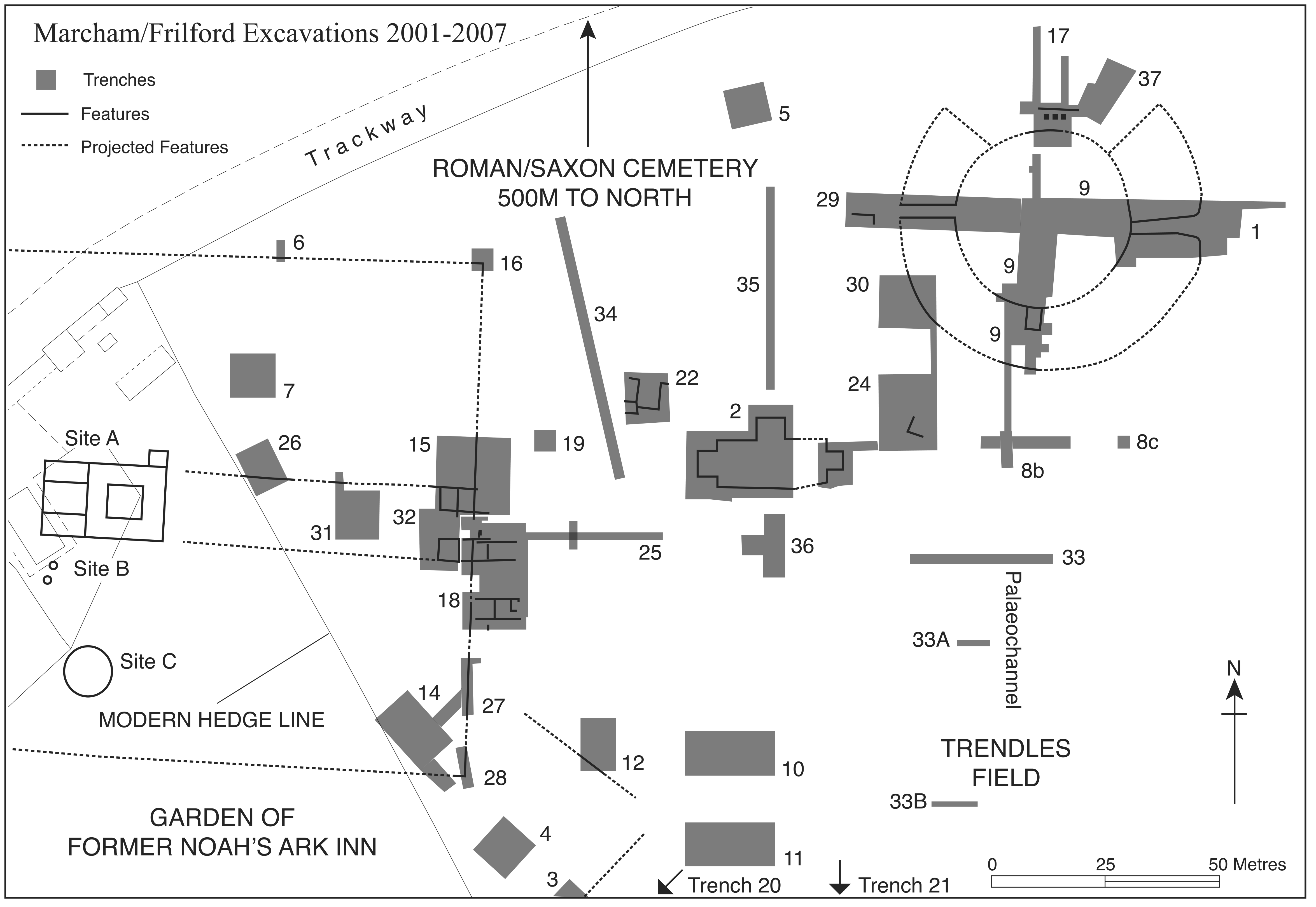
The temple complex (in the garden of the Noah's Ark Inn) was originally excavated by Bradford and Goodchild, who argued that the late Iron Age large circular structure, pits and a round ditched feature continued in use until the end of the Iron Age (fig. 1; Sites A, B and C).Footnote 3 The temple was built, in their estimation, c. a.d. 80–90 and showed direct continuity in time and in the religious character of activity with the Iron Age remains. Later excavations by Harding came to an opposite conclusion: the Iron Age activity ended earlier than Bradford and Goodchild thought, possibly in the middle Iron Age, and was in any case interpreted as domestic;Footnote 4 the Romano-British temple may not have been built until the second century a.d., representing a gap in time, but also a change in the nature of the site from profane to sacred. Neither group of protagonists directly discussed what was meant by continuity of use, either in terms of the practices at the site or referencing the problematical nature of recognising and dating the late Iron Age in this region. Much of the debate about the site since has been concerned with issues of continuity and the nature of the Iron Age activity on the site.
Overall site plan showing the trenches and main structures excavated between 2001 and 2007 as well as Bradford and Goodchild's Sites A, B and C.

In 1976 during crop-spraying over Trendles Field (to the east of the Noah's Ark Inn site), aerial photography revealed a circular structure, similar in form to a Roman amphitheatre. Small-scale excavations and field survey by Hingley revealed the stone walls of an arena, a stone structure at the southern point of this circular structure, and Roman occupation debris indicative of buildings between the temple and the circular structure.Footnote 5
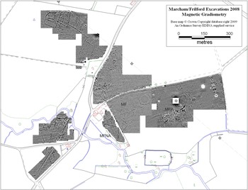
Prior to the recent excavations a geophysical survey was carried out, based partly on the results of this previous work with a view to evaluating the conclusions (fig. 2). The plot revealed a complex of ditches in the south-western corner of the site, a large rectilinear building in the centre, and the stone walls of the circular structure with features at its cardinal points. The recent excavations (fig. 1) concentrated on the temple complex and features to the east shown in the geophysical survey. The main zone of prehistoric activity was in the south-western corner of the site (Trenches 3, 4, 12, 10, 11 and 14); it included ditch complexes and a large group of intercutting pits. In the western part of the field, the excavations targeted the interior of the temple temenos, its walls and the buildings directly outside it (Trenches 6, 7, 14, 15, 16, 18, 26, 27, 28, 31 and 32). To the east, trenches were located over the interior, banks and cardinal points of the circular structure (Trenches 1, 8, 9, 17, 29, 30 and 37). Other ancillary structures and pathways articulating the site have been excavated in Trenches 2, 19, 22, 24, 25 and 36.
Plan showing the areas that have been subject to geophysical survey (MF indicates the area referred to in the text).

This article presents and discusses the considerable new evidence from Marcham in the light of debates about the use of the past in a variety of periods, prehistoric and later. In the process it is hoped to throw light on what was happening at this extensive and unusual site and also on aspects of worship in Roman Britain. The current ideas and analysis of the site from the 2001–7 seasons presented here supersede earlier interpretations and reports.Footnote 6
PREHISTORIC ACTIVITY
The main areas of prehistoric activity identified so far have been towards the south-western end of the site (Trenches 3, 4, 12, 10, 11 and 14). There is also geophysical evidence from the far eastern part of the field, outside the current excavation area, for a large complex of pits and ditches of probable Iron Age date, which when excavated may cast further light on the question of continuity in this area.Footnote 7
Bronze Age activity centred on two perpendicular ditches in Trenches 3 and 4, from one of which a middle Bronze Age bucket urn was excavated. During Bradford and Goodchild's excavations in the 1930s significant Iron Age activity was identified behind the Noah's Ark Inn at Sites A, B and C.Footnote 8 At Site B, referred to as the ‘main settlement’, 40 circular pits were excavated, the majority of which were clay-lined. An Iron Age roundhouse, c. 3 m in diameter, represented by eight post-holes, overlay the pits. At Site A to the north, under the north-western corner of the temple, there was another post-hole structure, c. 5 m in diameter with a double internal partition. A high percentage of the pottery assemblage recovered from this area comprised well-made, burnished wares, including four Frilford bowls. This structure had been destroyed by fire and was sealed by burnt material. The burnt layer was immediately overlain by the make-up layer for the Roman temple. To the south, at Site C, the circular Roman building (commonly referred to as the ‘rotunda’) overlay a penannular Iron Age ditch, which was c. 12 m in diameter. Inside the enclosure the eastern end was partitioned by two rows of three double post-holes, in front of which was a square pit. All the features were deliberately backfilled in the Roman period.
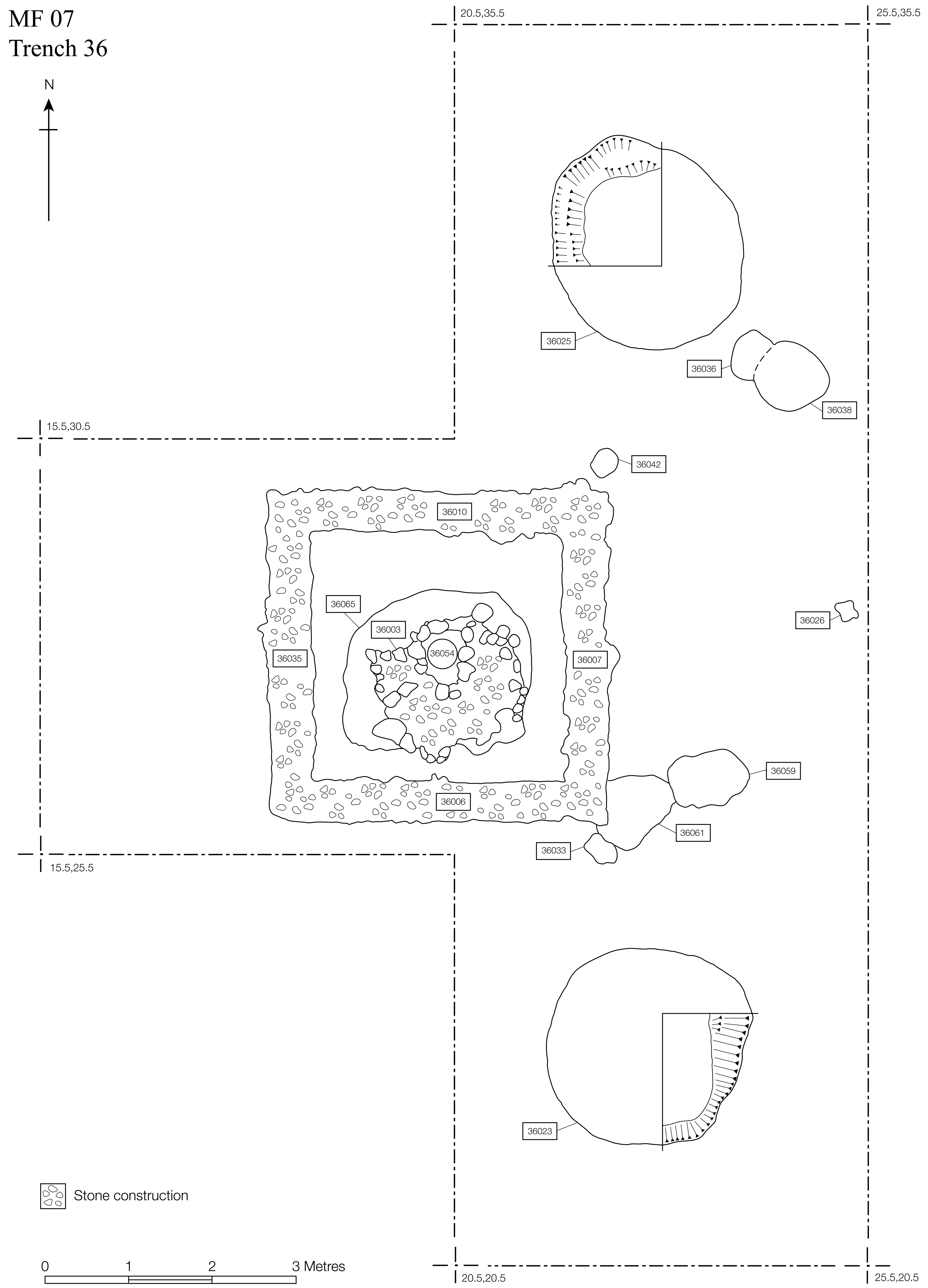
The Iron Age activity in the current excavations — comprising pits, post-holes and an enclosure ditch — was also focused on the south-western area of the site. Three circular early Iron Age pits in Trench 3 seem to have functioned as a precursor to the early Iron Age enclosure ditch (fig. 3). To the north, in Trench 12, three intercutting early Iron Age pits and a single discrete pit were excavated. The largest concentration of pits (c. 32) was found to the west in Trench 14, the majority of these being intercutting. Unlike the pits further to the west within Bradford and Goodchild's Site B, which were probably used for storage, none had clay-linings. This suggests that these groups of pits had different functions, the purposes of which may become clearer once analysis of the finds within them has been completed. In the centre of the site, seven Iron Age pits were identified in Trench 2, most of which contained Iron Age pottery. In addition, a large amount of residual Iron Age pottery was found in this area. To the south, in Trench 36, was another cluster of Iron Age pits and features, including two large Iron Age pits. Significantly, these appear to have been used in the siting of a shrine in the Roman phase of the site (see below) (fig. 4).
Plan of intercutting ditches and pits in Trench 3.

Plan of Trench 36 showing the two Iron Age pits in association with the Roman shrine.

HOW CONTINUOUS IS CONTINUITY? THE CASE OF IRON AGE MARCHAM
Since its initial excavation by Bradford and Goodchild, the continuity between the Iron Age and Roman structures inside the temenos area, particularly their ‘Site C’, has been much debated. Bradford and Goodchild originally interpreted the penannular ditch within Site C as having ritual significance. This became the accepted interpretation, until Harding revised the position in 1987, when he concluded that the Site A roundhouse did not have ritual significance.Footnote 9 Since then the penannular structure has more commonly been interpreted as domestic rather than religious.Footnote 10 Subsequently A. Smith, with particular reference to Marcham, has argued that retrospective religious interpretations of Iron Age sites, based on Roman sacred spaces on the same site, are only viable with direct continuity, i.e. where the earlier Iron Age structures were still in use at the end of the Iron Age.Footnote 11 The direct continuity from the Iron Age into the Roman period at Marcham has been questioned owing to a lack of firmly identified late Iron Age pottery, but does this preclude the possibility of any kind of continuity?
It would appear that in the Roman period several earlier features, Bronze Age as well as Iron Age, must have remained visible in the landscape. The two perpendicular Bronze Age ditches in Trenches 3 and 12, for example, were backfilled in the Roman period and it can be assumed, therefore, that they must still have been visible as distinctive linear hollows at this time. At Site C the penannular ditch, post-holes and pit were deliberately filled with clay in the Roman period in preparation for the building of the ‘rotunda’. The recorded sections through Site C illustrate that the ditch had only silted to about half its depth before it was backfilled and was, therefore, still a considerable curvilinear cut feature at this point.Footnote 12 Three of the post-holes illustrated (Post-holes 1, 3 and 6) were entirely filled with clay with no evidence for silting, which suggests the possibility that at least some of the posts were still in situ and so presumably visible before being deliberately dismantled for the construction of the ‘rotunda’. It is also possible that a similar situation pertained in Trench 18 where three post-holes were deliberately backfilled prior to the construction of the stone buildings outside the temenos (see below).
Furthermore, the shrine in Trench 36, on the pathway between the temenos and the semi-amphitheatre, seems to have been deliberately sited in relation to the two large Iron Age pits described above (fig. 4). The upper fills of these pits contained Romano-British pottery, which suggests that they also were open and still visible at the time of the shrine's construction. This shrine seems to play a significant role in the articulation of the two major parts of the site; its deliberate siting on the alignment of the Iron Age pits indicates that reference to past activities on the site may have been a key contributing factor to the design and co-ordination of the Romano-British religious complex.
This type of commemoration of the past and site reuse is reminiscent of the situation at Haddenham, Ferrybridge, and St Albans.Footnote 13 At Haddenham, Cambs., a Romano-British shrine was built on the edge of a Bronze Age barrow.Footnote 14 In the second century a.d., at Folly Lane, St Albans, a building in the form of a Romano-Celtic temple was built over the pyre mound in a mortuary enclosure that dated to c. a.d. 55.Footnote 15 Also, it appears that the feasting deposit of c. 250 cattle at Ferrybridge was made in the Roman period, significantly later than the middle Iron Age chariot burial.Footnote 16 These examples strongly suggest that direct continuity was not always necessary for the maintenance of links with the past.
The choice of areas for deposition also hints at some kind of continuity. The siting of the favissa-like pit (discussed below) in the vicinity of the large group of Iron Age pits in Trench 14, for example, does not appear to be merely coincidental. Equally, the deposition of the bronze votive sword and shield, the iron spearhead and the corn-muller in Bradford and Goodchild's square pit seems significant; should this be interpreted, not as a ritual of either termination or commencement, but rather as a ritual of persistence, an acknowledgement of earlier practices? In these ways, maybe there are references to the past at Marcham similar to those noted elsewhere by Hingley and Fulford.Footnote 17 Hingley suggests that some acts of iron deposition at Gretton, Billingborough, Nadbury and Kilverstone hint at the commemoration of settlement features and even whole settlements.Footnote 18 In looking at continuity of practice Fulford develops the work by Merrifield on ritual deposition in Iron Age and Roman Britain.Footnote 19 Fulford argues that the structured deposits in pits and wells from a selection of Roman period sites in southern England (Silchester, London, Neatham, Baldock, St Albans, and Portchester) recall British Iron Age practices, which he refers to as pervasive ritual behaviour. This approach does not call for direct continuity, but rather allows more room for wider strands and themes to provide links with the past in the Roman period.
The evidence presented here would suggest that the physical vestiges of the Iron Age activity persisted into the Roman-period landscape at Marcham. Furthermore, it could be argued that an understanding of the importance of the area also persisted into the Roman period, so that this site was deemed appropriate for and worthy of a large religious complex. The persistent activity in, and use of, this landscape suggests that the site carried some significance, potentially ritual, for its users into the Roman period.
MARCHAM IN THE ROMAN PERIOD
During the Roman period Marcham developed into a thriving rural sanctuary, comparable with the religious complexes at Nettleton Scrubb (Wilts.) and Springhead (Kent), with a temenos enclosing at least two ritual buildings (the temple and the ‘rotunda’), ancillary buildings outside the enclosure, ancillary shrines beyond the temenos, and a semi-amphitheatre, all connected by a system of pathways.Footnote 20 The exact chronology for the sequence of constructing these buildings is not yet known, but it seems that the large Trench 2 building was one of the latest to be built.
The position of the temple complex in the wider landscape was similar to other temples in southern Britain. The temenos and its temple lay in the vicinity of several villas, three of which (at Frilford, Garford and East Hanney) lay within 1–5 km of the site.Footnote 21 This fits a pattern seen across southern Britain where over half of the known rural temples had a villa within a 4 km radius.Footnote 22 A similar number of temples in southern Britain were also within 2–3 km of a Roman road, as at Marcham, which lay close to a road crossing the Vale of the White Horse to Wantage.Footnote 23 The complex was also close to the Roman settlement adjacent to the Thames at Abingdon to the east. In these ways, while a rural sanctuary, Marcham was not isolated, but tightly integrated into its surrounding landscape.
THE TEMPLE TEMENOS, ASSOCIATED BUILDINGS AND ACTIVITIES
Part of the temple precinct, excavated by Bradford and Goodchild in the garden of the Noah's Ark Inn, lies within the recently excavated area. Several trenches during the 2001–7 seasons have been excavated in order to elucidate the nature of the activity inside the temple precinct, the temenos boundary, and the activity outside the precinct, but directly associated with it. The combination of structural features at Marcham fits into a common Romano-Celtic type known across southern Britain — including a temenos boundary, an internal cult focus, ancillary buildings, pits, a hearth, and a monumental entrance.
ACTIVITY INSIDE THE TEMENOS
In the 1930s Bradford and Goodchild excavated the main temple (Site A) and the ‘rotunda’ to the south (Site C).Footnote 24 A first- or second-century date has been suggested for the primary construction of the temple. The original temple plan, typical of Romano-Celtic temples, comprised a square cella (c. 7.5 m square), the walls of which had been robbed systematically, surrounded by a portico (c. 16.5 m square), open to the east. The temple floors were not found in situ, but red and yellow tesserae from the robber trenches suggest that they were plain, tessellated floors. A pathway, c. 3 m wide, surrounded the outside of the temple. To the west of the temple was a large annexe divided into three separate rooms; this appears to have been a later addition. A gravel pathway ran around the exterior of the annexe, sealed under which was a Trajanic sestertius (a.d. 98–117) and a samian sherd of probable Domitianic date (a.d. 81–96). A second, smaller annexe was attached to the north-eastern corner of the temple.
Leading from the eastern side of the portico was a gravel and stone entrance-pathway (c. 7 m wide), which had three layers of metalling, on the latest of which 78 third- or fourth-century coins were found. In the current excavations an area of gravel metalling has been traced further to the east in Trenches 26, 31, 32 and 15; in the latter two trenches it lies between the structures flanking the entrance (see below) and must be a continuation of the pathway leading to and from the temple. Excavations in Trench 26 revealed a line of substantial post-holes running along the northern edge of the pathway. These posts were replaced later in the Roman period by a masonry wall, which was traced into Trench 31 where it appeared to be heading towards the temenos entrance.
The ‘rotunda’, which was built on top of the Iron Age penannular ditch, was located to the south of the temple and was c. 11 m in diameter (fig. 1). There was little to date the original construction of the building, but the lack of Roman material from the Iron Age ditch-fill suggests that it was early in the Roman period. The building seems to have burnt down late in the Roman period.
To the north of the entrance inside the temenos (Trench 15), a plastered square, possibly some form of altar base, was excavated. Associated with this base was an articulated sheep burial with a small Oxfordshire colour-coat vessel. A very large pit was also excavated inside the south-eastern corner of the temenos (Trench 14). The pit fills were rich in pottery and animal bone, including sheep and cattle skulls. Overlying this pit, and probably developed as a result of it, was a large midden, which contained large amounts of oyster shell, animal bone and pottery.
In general, though, the area inside the temenos was comparatively sparse in small finds, with the exception of the south-eastern corner and the pathway which led from the temenos entrance to the temple. At Bath, Uley and Pagans Hill most of the temple courtyard was also kept clear.Footnote 25 The large pit and midden in the south-eastern corner of the temenos at Marcham suggest that this area was used for the disposal of material that may have originally been deposited elsewhere in the temenos. The presence of vessel glass, oyster shells and a large amount of animal bone in the pit suggests that the activities inside the temenos may have included feasting and/or animal sacrifice. The sacrificing of animals as part of the rituals associated with the temple is confirmed by the articulated sheep burial found to the north of the entrance. The pit in Trench 14 seems to have been used for the careful disposal of items that had been imbued with a sacred power, and resembles a favissa.Footnote 26 Can it be entirely coincidental that the place chosen for this pit was the same area as the high concentration of Iron Age pits? It seems possible — given that these Iron Age pits were not clay-lined and so were probably not for storage, unlike the pits found in the 1930s — that this particular location had a persistent ritual significance.
The pathway had a higher concentration of finds than elsewhere inside the temenos and assemblages from this area were dominated by coins: for example 45 coins (out of a total of 60 small finds) from Trench 31, as well as 78 coins from the earlier Bradford and Goodchild excavations. This suggests that, particularly in the later period of its use, the temple pathway, like the entrance, was a focus for coin deposition. The presence of the posts and, later, the wall along the side of the pathway indicates that movement inside the temenos was restricted and controlled, with deviation off the main path discouraged by a physical barrier. The lack of finds elsewhere within the temenos may reflect this restricted access to areas away from the main pathway.
THE TEMENOS BOUNDARY AND ENTRANCE
The temenos boundary was revealed in five trenches (6, 15, 16, 18, 28). This evidence has confirmed the locations of three sides of the temenos, the north-eastern and south-eastern corners, and the entranceway. The fourth side may lie on the land of the former Noah's Ark Inn or further to the west of the modern road. The majority of the temenos wall had been robbed and its line survived as a wide robber trench.
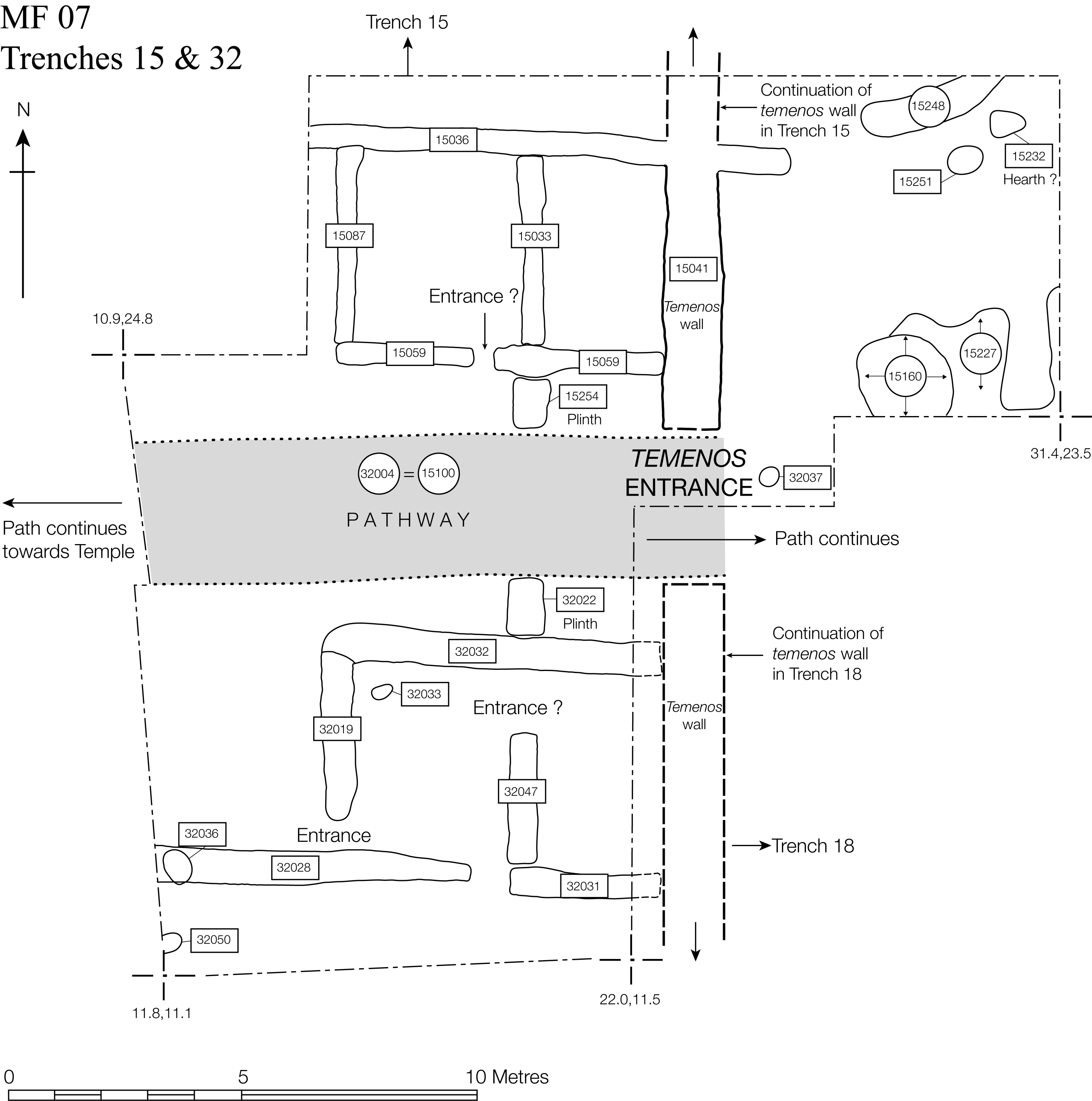
The entranceway in Trench 15 was monumentalised by structures to the south (Trench 32) and north (Trench 15) of the pathway inside the temenos, which mirrored each other in alignment, layout and dimensions (fig. 5). Both structures have an internal division to create two rooms. The exterior walls of both buildings appear to have continued further west, suggesting that a third, open-fronted room may also have existed. Nothing has survived to suggest a possible function for the rooms or the activities that might have taken place in them. Two opposing plinths sited either side of the pathway on the same alignment as the internal partition walls might have provided foundations for an arch or columns, monumentalising the entranceway. These would have framed the view from the entrance and guided the eye towards the temple building straight ahead.
Composite plan of Trenches 15 and 32 showing the structures inside the entrance to the temenos.

A defined temenos boundary and the entrance through this boundary seem to have been emphasised generally in Romano-Celtic temples in southern Britain, as they are at Marcham.Footnote 27 The temenos boundary seems to demarcate the formalised ritual focus of the site. As well as providing a physical barrier into the temenos, the wall at Marcham may also have prevented visual access and provided privacy. It is also conceivable that a wall may have deadened any sounds (of animal sacrifice; singing?) and limited any smells (from cooking?) emanating from the temenos area, in which case the wall would have denied almost all sensory experience of the activities inside to the uninvited. As a liminal zone between the formalised ritual space and the non-formalised, external space, the entry threshold would have become a special focus. The entrance would not only have provided physical access, but also potential visual axes. The visual access may have been limited to the temple itself owing to the presence of the structures directly inside the entrance; arguably this could have had the dual effect of preventing too much visual access to areas and activities beyond the temple as well as emphasising the importance of this focal structure. This focus on the temple would have been further determined by the wall flanking the pathway leading to the temple, which would have effectively channelled the viewer's line of sight. As well as being marked by seemingly monumentalised entrance structures, this liminal zone at Marcham seems also to have been emphasised by a high concentration of coins. With the exception of the late Roman building in Trench 2, Trenches 15 (160 coins) and 18 (143 coins) had the largest coin assemblages on site.Footnote 28 The high numbers of coins, particularly from the entrance area in Trench 15, suggest that coin deposition as acts of personal worship may have occurred here, presumably by those who did not, or even could not, enter the temenos area. Alternatively, these coins may have been deposited as tokens of entry when passing through the entrance into the temenos.
ACTIVITY DIRECTLY OUTSIDE THE TEMENOS
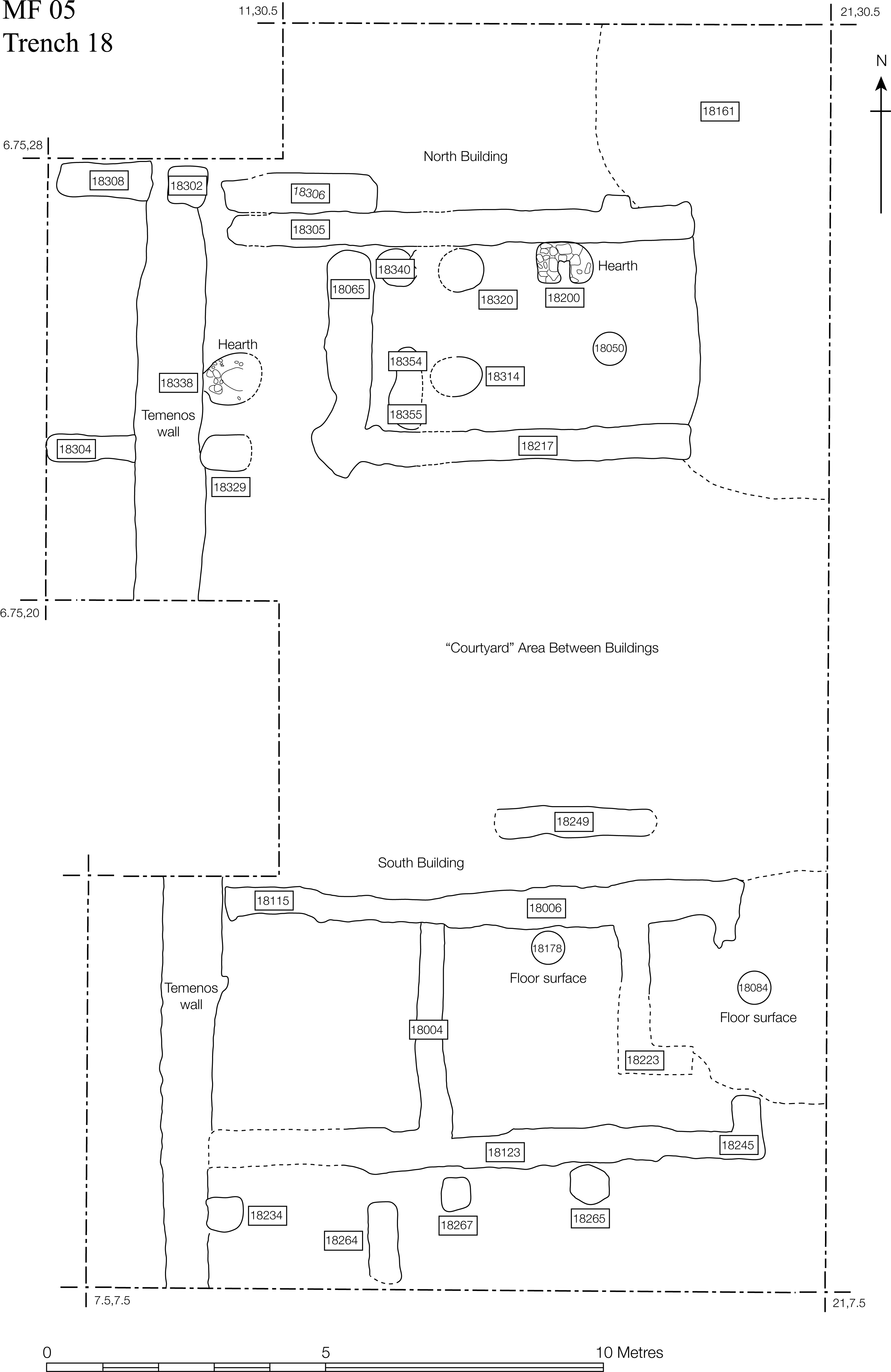
The excavations so far have provided evidence for several buildings directly outside the temple precinct (fig. 6). Two small, three-sided buildings, each open to the east, were excavated to the south of the temenos entrance; these were separated by a walled, gravel-floored courtyard area, also open to the east. Both buildings were divided into two rooms and seem to have had two phases of use. In the northerly building, the smaller limestone hearths were replaced by larger hearths, one of which was contemporary with the latest floor in the building. The central pathway through the temenos seems to have continued eastwards through the entranceway, where it extended east up to a possible north–south-aligned path (in Trench 25), perhaps connecting to the building in Trench 22 (see below). The east–west-aligned pathway probably extended beyond this point towards the southern side of the semi-amphitheatre. Other cobbled surfaces directly outside the temenos wall were excavated in Trenches 6, 14 and 28, which may suggest that empty spaces outside the temple precinct were also cobbled and, to some extent, formalised.
Schematic plan of the buildings in Trench 18 outside the temenos wall.

Overall, the area immediately outside the temenos produced high concentrations of coins and vessel glass, but relatively low concentrations of copper-alloy and worked bone objects (high for the site as a whole, but low in comparison with Trenches 24 and 8b, see below). As noted above, the coin deposition may result from acts of personal worship in Trench 15. The same may be true of the coins in Trench 18, but it is also possible that these were secondary depositions, i.e. they had been removed from their original place of deposition, possibly to make room for further deposits. Distribution analysis of the coins in the final phase of post-excavation analysis may shed light on this question.
Almost half of the vessel glass assemblage on site in 2001–6 came from Trenches 15 and 18 (in contrast to 13.2 and 6.74 per cent from Trenches 24 and 8b respectively). Initial observations of the pottery assemblage also suggest that more finewares (including flagons and imported drinking vessels) and mortaria came from these trenches than elsewhere on the site. The vessel glass and ceramic assemblages suggest that another of the activities that took place in these buildings at the entrance to the temenos was feasting and dining. The hearths may relate to these activities as well, but it is more likely that they were used for small-scale metalworking (as at Woodeaton and Uley),Footnote 29 possibly producing copper-alloy objects (for sale as votive offerings?) since this is the main area of the site to have produced copper-alloy slag.
THE SEMI-AMPHITHEATRE
This large circular feature, first discovered by aerial photography in 1976, sits at the northern end of a north–south-aligned ‘palaeochannel’Footnote 30 (fig. 1). The structure comprised an arena wall, c. 40 m in diameter, surrounded to the south, east and west by a low earthen bank. Trenches 1, 9, 17 and 29 targeted features at each of the cardinal points. The main entrance seems to have been on the western side. The excavations have also examined the banks and a large area inside the arena.
This structure has been treated as a rural amphitheatre since Hingley's identification and initial excavation.Footnote 31 The structure has some similarities with other British amphitheatres, for example it was created by enlarging an existing natural depression, the spoil being used to create the banks; it had a box-like annexe and it was furnished with a central drain. The present authors have always cast some doubt on this simple interpretation, primarily because of the structure's shape and the fact that the banks do not entirely surround the arena.Footnote 32 The closest parallels for this type of structure seem to be found among the semi-amphitheatres of northern and central Gaul, which will be discussed below.
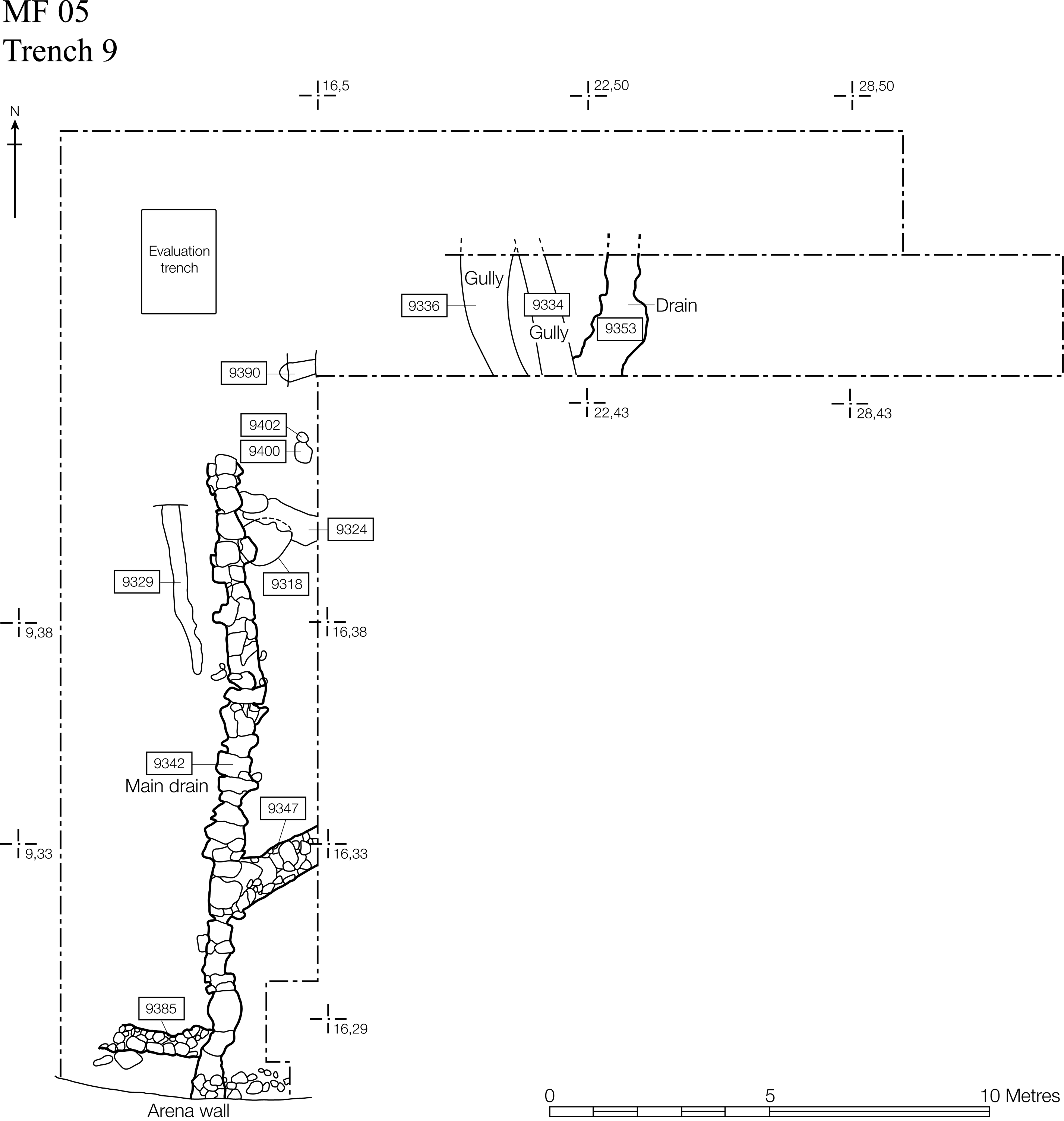
THE ARENA, INCLUDING THE DRAINAGE NETWORK AND ‘PALAEOCHANNEL’ (fig. 7)
The arena at Marcham was circular, rather than oval as was typical of the majority of amphitheatres in the Roman world. The original amphitheatre arena at Silchester was also circular, but it was adapted in its later two phases to a more typical oval shape.Footnote 33 Dorchester also had a circular amphitheatre, but this must relate to its unusual history, being on the site of a Neolithic henge monument and following the shape of this earlier feature.Footnote 34 The arena at Dorchester, however, compensated for the external shape and was more oval in plan. The arena at Marcham, therefore, was seemingly unusual in deliberately maintaining a circular layout.
Schematic plan of the buildings in Trench 18 outside the temenos wall.

As the land inside the arena was stripped to provide material for the banks, the Roman deposits directly overlay or were cut into the natural clay deposits, a style of construction which is typical of amphitheatres in Britain. The earliest event identified in the arena was the construction of the central, north–south-aligned main drain. Similar central drains have also been found at the Chester, Caerleon and London II amphitheatres.Footnote 35 Two oak stakes relating to the primary construction phase were preserved in the arena. One of these stakes was located on the line of the drain and was probably used in the surveying and laying out of the drain. It has been radiocarbon dated to 1910±60 b.p. (Beta-182615), Cal 30 b.c–a.d. 245 (at two standard deviations). The other stake, from a primary phase rubble dump, has been radiocarbon dated to 1860±50 b.p. (Beta-228365), Cal a.d. 50–250 (at two standard deviations). This drain exited the arena under the southern wall. Two smaller drains, which seem to be part of the original drainage plan, fed into the central main drain from the east and the west. These drains did not form a continuous perimeter drain as at the Chester (Ib) and Caerleon military amphitheatres,Footnote 36 rather their access points into the main drain were staggered, probably to reduce the effect of large volumes of water collecting at a single point and putting stress on the system. Sand was subsequently spread over the majority of the interior, sealing the drain and forming the arena floor surface. The sand was sterile, with little or no artefactual material, which suggests that the arena was kept clean and the sand was replaced regularly.
THE BANKS
Since the banks were created by levelling the area that was to become the arena and placing the excavated material around its perimeter, the bank deposits were characteristically interleaving clay and sand deposits. These banks were not subdivided by radial walls, which is typical of other British amphitheatres, with the exceptions of the military amphitheatres at Caerleon and Chester II.Footnote 37 The construction of the banks was not consistent in height or length, which may indicate that work was undertaken by different gangs. In several places evidence was found for a stone revetment to the bank, perhaps pointing to maintenance of the banks over time. In addition, the recent excavation of various sections through the banks has revealed no traces of seating in the form of post-holes or beam-slots for wooden superstructures (as at Chester Ib and Caerleon), nor terraces for a tiered, standing crowd (as at Silchester, Cirencester and Carmarthen).Footnote 38 The bank does not seem to have entirely encircled the arena, for no bank deposits were identified to the north of the arena in Trench 17 and the terminus of the north-eastern sector of the bank was confirmed in Trench 37. Instead, an east–west-aligned wall with square stone post-pads in front was revealed c. 5 m to the north of the arena wall in Trench 17.
Additional banks flanking either side of the western entrance (Trench 29) were also constructed; these were apparently contemporary with the main perimeter bank. To the south of the western entrance a three-sided building was cut into the top of the southern flanking bank and so must have been a later phase of activity. Inside this building five clusters of small upright stones were excavated. Another two stone clusters were found outside the building, in the area between the northern wall and the cobbled pathway. These stone clusters are similar to those found in Trenches 24 and 8b to the south of the semi-amphitheatre, but lack the closely associated deposition of personal items that is characteristic of these trenches.
THE WALLS AND ENTRANCES
To the east, north and west the bedrock was cut and modified for the construction of the arena wall. The first phase of arena wall survived to a maximum height of c. 1.2 m. The fact that this wall was not robbed for stone and was largely intact suggests that the robbing of the temple, temenos wall and the Trench 2 building, for example, may have taken place after the arena had mostly silted up, possibly in the medieval period.
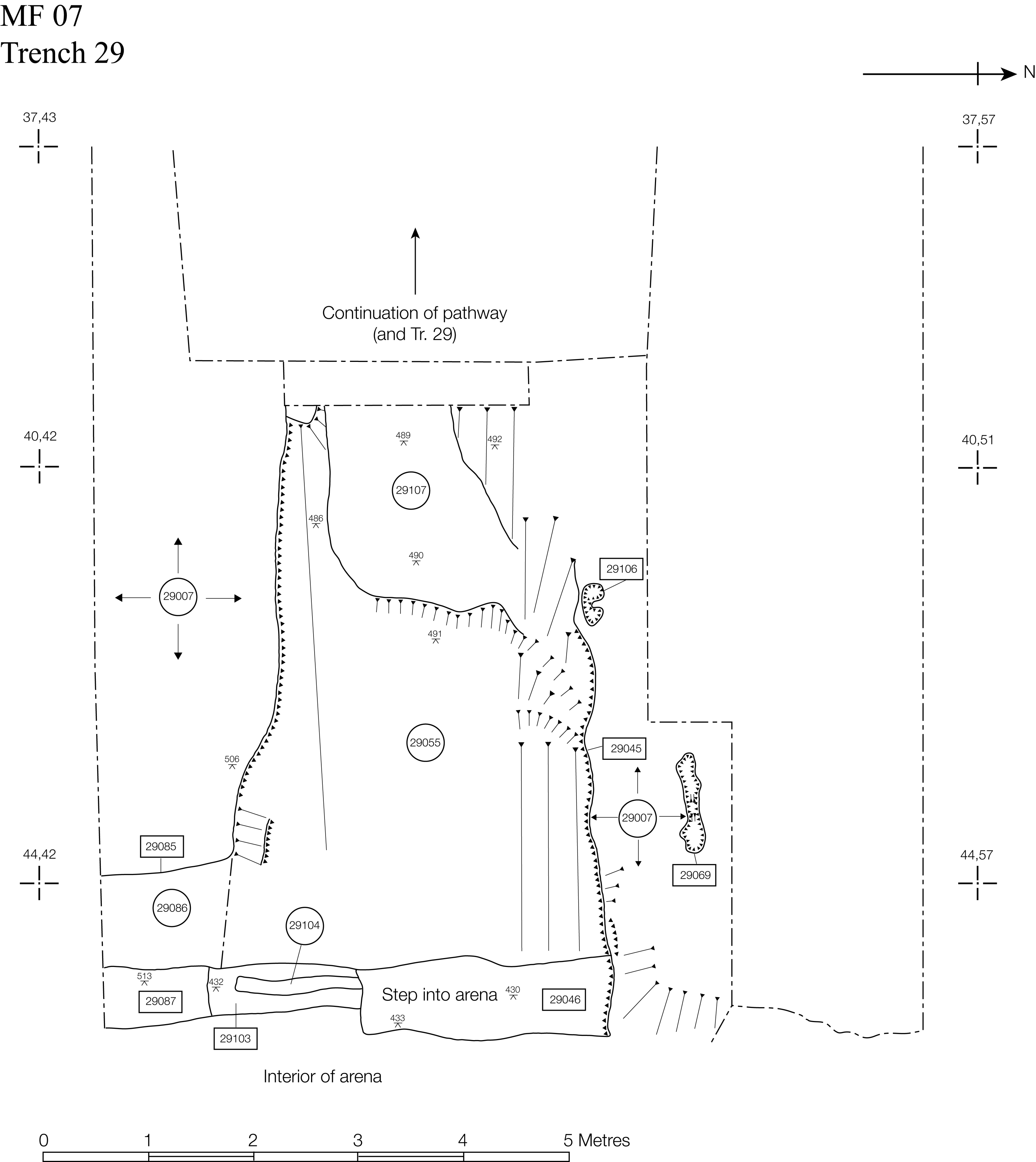
In its original phase the arena wall was continuous with a single break for an entrance at the western point (Trench 29; fig. 8), which was cut through the bedrock. Pieces of pink plaster found in the fill of this entrance may have been used to cover, smooth and decorate the exposed bedrock; a similar plaster was used in the Cirencester amphitheatre.Footnote 39 A cobbled pathway sloped down into the arena, leading to a limestone step with a groove running through its centre, which suggests that it may have been possible partially to block the entrance. The provision of only a single entrance originally is in contrast to most amphitheatres, which have an entrance at each of their long axes at least. Dorchester also had only a single entrance in its original phase, but unlike Marcham, a second entrance was introduced in a later phase.Footnote 40
Plan of the western entrance to the arena in Trench 29 as excavated in 2007.

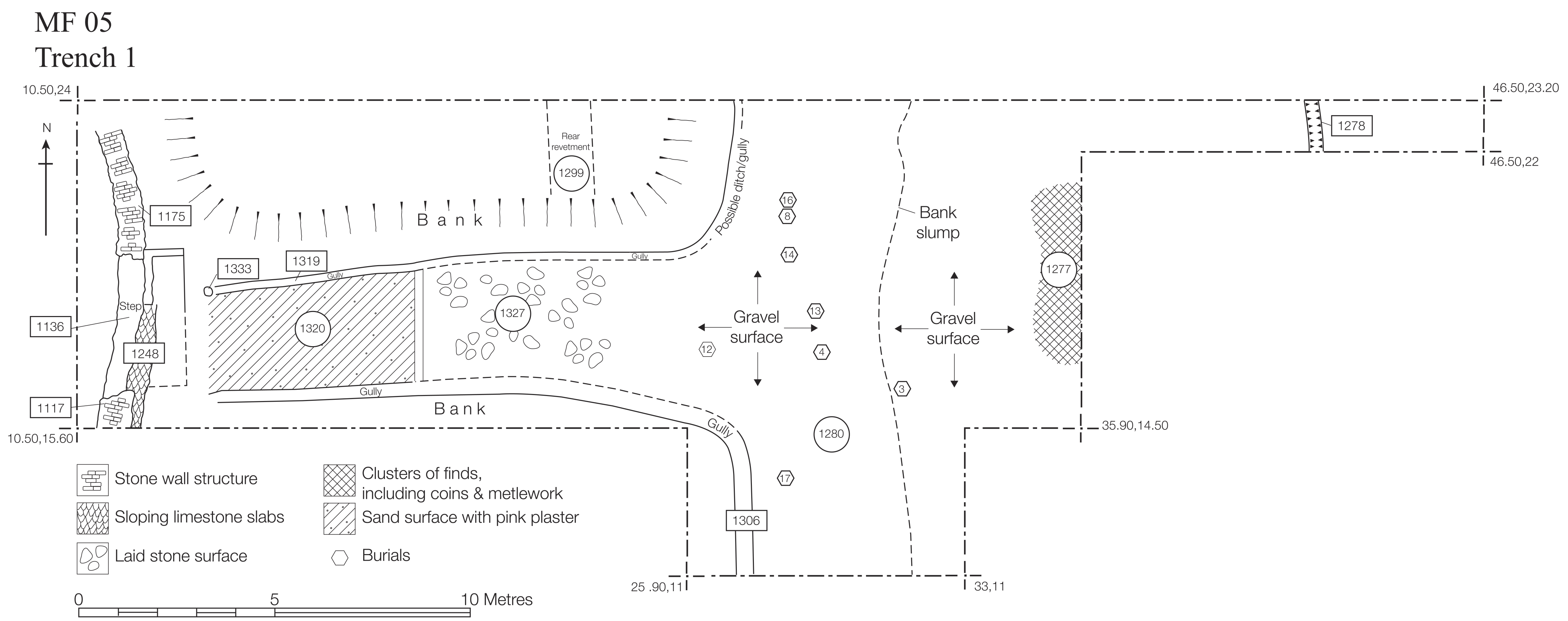
A second break, c. 2 m wide, was inserted into the arena wall at Marcham on the eastern cardinal point at a later date to accommodate a broad ledge of limestone several courses lower than the top of the wall (fig. 9). No features were identified which may have facilitated access from this ledge into the arena, though cuts into the bedrock may be evidence for a platform in the area of the ledge. It is possible, therefore, that this break in the wall provided visual, rather than physical, access to the arena. In addition, a break was made through the bank at this point, providing a funnelled access to the ledge.
Plan of the eastern break through the arena banks in Trench 1, also showing the locations of the later burials.

Probably at the same time as the insertion of this ledge, the arena wall was reconfigured and heavily remortared. White plaster decorated with red lines seems to have been applied to the walls of both phases, presumably to disguise the difference in construction technique. Evidence for plaster has also been found at Chester Ib, Caerleon, Chichester, and Cirencester II.Footnote 41 At Caerleon the plaster, found on the external arena walls, the main entrance and staircases, was decorated in red paint to imitate masonry joints, which is similar to the plaster used in the interior of the Marcham arena.Footnote 42
At the southern point of the arena lies a rectangular stone structure, which was first discovered by Hingley.Footnote 43 In its present state, it is unclear how access was gained into this space, but later rebuilds of the arena wall suggest that it was from the arena. It would appear that this structure was not an original part of the concept and that an area of the bank had to be removed for its insertion. While it has been postulated that the structure may have been related to the main drain, which ran under its base (see above), the lack of waterproof lining (opus signinum) inside the structure and the fact that the drain was sealed by its capstones, preventing significant volumes of water from escaping, suggest strongly that the room did not have a water-regulating function. This structure does have parallels at Chester Ib, Caerleon, Silchester I and II, Dorchester, Cirencester II, and London II, which have been interpreted variously as animal pens, shrines or tribunalia;Footnote 44 at Marcham the last interpretation appears to be the most likely (see below).
ACTIVITY TO THE SOUTH OF THE SEMI-AMPHITHEATRE
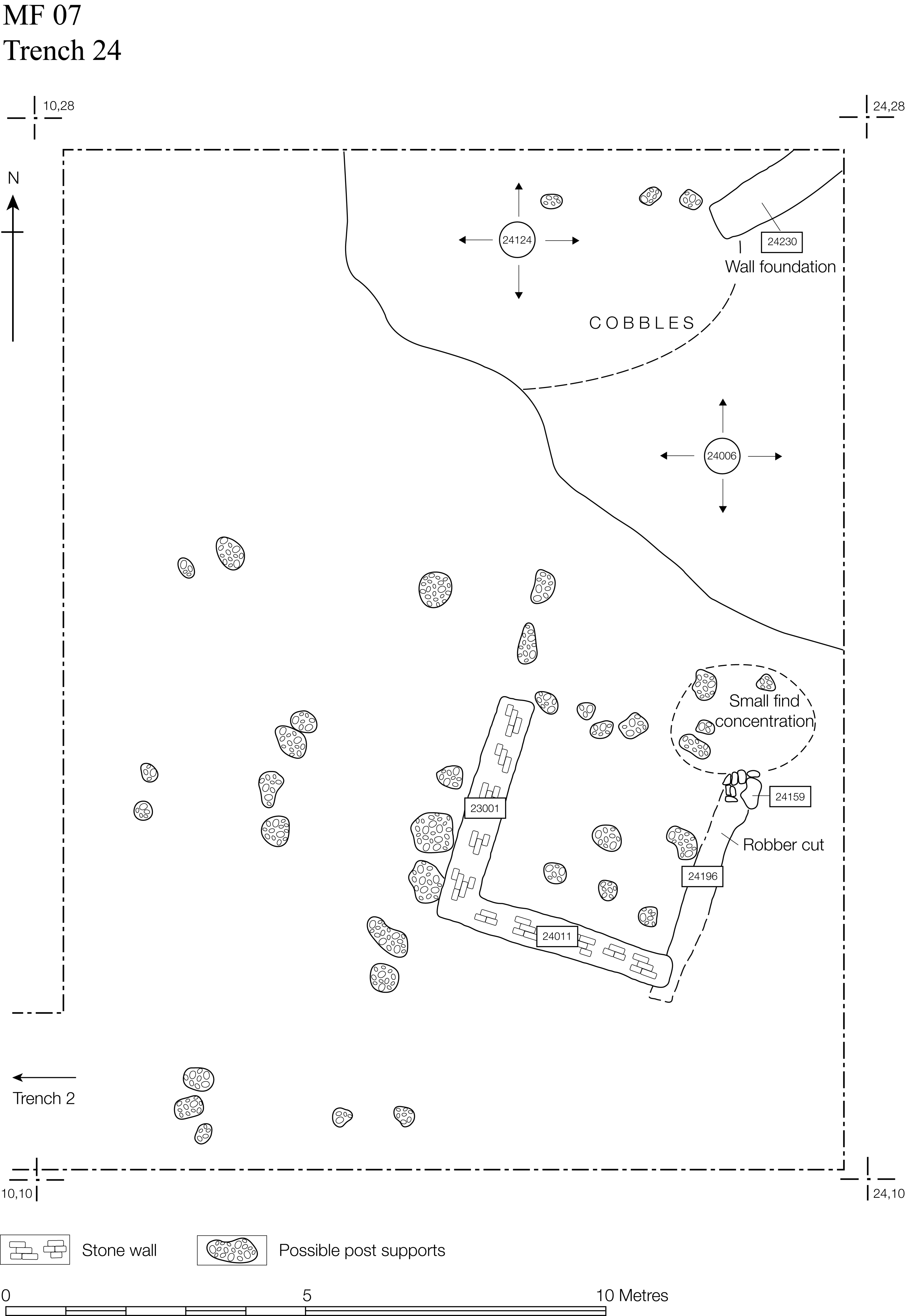
A probable shrine and ritual activity have been identified at the back and to the south of the banks of the semi-amphitheatre in Trenches 8b and 24. A well-constructed, three-sided building was revealed in Trench 24 (fig. 10). The building seems to have been open-fronted, facing towards the semi-amphitheatre, which may explain why, unlike the majority of buildings on the site, it was not orientated on the cardinal points. An exceptionally high density of small finds, in particular personal items of first- or second-century date, was excavated in this area. These finds seemed to cluster around the structure and around groups of small upright stones. These small groups of stones do not seem to be post-packing, for no cuts were found, rather they may have been deliberately placed into the ground as make-shift altars or loci for deposition. The votive nature of these finds and their deposition patterns is strengthened by a sheep/goat burial to the south of the three-sided structure. This focus of deposition around the semi-amphitheatre was also encountered to the west in Trench 8b, which was located close to the western edge of the ‘palaeochannel’. Here large numbers of bronze, glass and iron objects were found, as well as seven further small clusters of stones.
Schematic plan of Trench 24 showing the location of the shrine, possible post-supports and small finds concentration.

INTERPRETING THE CIRCULAR STRUCTURE AT MARCHAM
The current evidence indicates the following basic reconstruction of the structure and its sequence. In its initial phase the structure had a circular arena with a sand-covered surface. The arena was encircled by a masonry wall c. 1 m high (minimum), which had an opening to the west. It is unclear if the wall was plastered during this phase. The wall itself was surrounded by a bank, which sloped evenly to the south, but was steeper towards the east. There is no evidence that the bank was terraced, nor did it support a wooden superstructure for seating. The bank did not run around the whole perimeter of the structure, but seems to have terminated to the north-west and north-east. Instead of a bank at this point, there were at least three postpads, which presumably supported a row of wooden posts, behind which rose a straight section of wall. To the south, a masonry drain exited under the walls and bank. Seemingly at a later date a rectangular, masonry annexe was constructed outside the arena wall to the south, over the line of the drain. The entrance to the arena lay to the west and the pathway in seems to have been flanked on either side by further banks. Later, a second entrance pierced the eastern side of the arena wall. This entrance seems primarily to have been for visual, rather than physical access. Possibly at the same time the arena walls underwent some modifications and upper sections of a different build were added. In this phase white plaster with red lines (mimicking masonry) was applied to the arena walls.
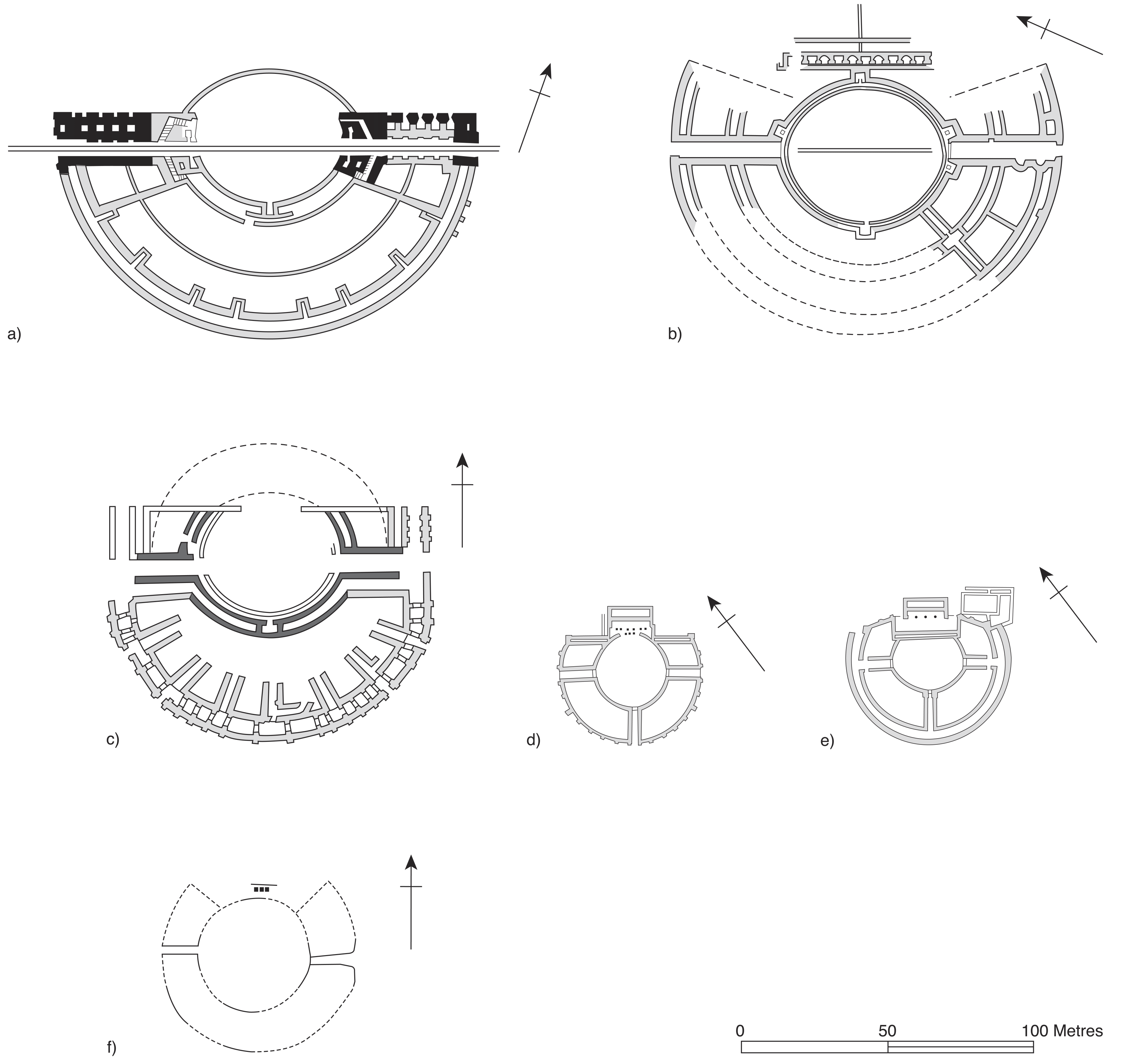
While the circular structure at Marcham has similarities with other British amphitheatres, it also has several anomalous features, which make it distinct. The substitution of a bank for a linear façade to the north provides the key to these anomalies and the interpretation of the structure. This type of structure — with an amphitheatre-like performance space as well as theatre-like banks and façade — is grouped by Golvin under the term ‘mixed edifice amphitheatres’, in particular the ‘semi-amphitheatre’ type.Footnote 45 This type was prevalent in northern and central Gaul (Galliae Belgica, Lugdunensis and Aquitania), where sixteen are known: six of which were constructed in the first century a.d.; nine were Hadrianic (a.d. 117–38); and a single example was dated to the third century a.d. The semi-amphitheatre type is somewhat distinct from the theatre-amphitheatre type, such as that at Verulamium (second phase), in having a full arena space, rather than dedicating some of the arena space to a stage, but these should perhaps be seen as fitting into a spectrum rather than being treated as distinct architectural classes (fig. 11).Footnote 46 Another common feature of these semi-amphitheatre types is that they have a more circular arena than is typical of an amphitheatre, as for example at Lillebonne (Juliobona). Golvin suggests that this increased roundness may be owing to a need or wish for better acoustics, which would be provided by semi-circular seating or viewing arrangements.Footnote 47 In this case the structure to the south of the arena at Marcham would have been ideally situated for visual and audible access to the events inside the arena and may therefore have been a tribunal reserved for dignitaries. The space provided by the circular arena would allow for physical activities, such as combat, to be performed as well, making the structures multipurpose.
Plans of comparative semi-amphitheatres and theatre-amphitheatres in Britain and Gaul: (a) Grand (Golvin 1988, pl. 68.1); (b) Lutèce, Paris (Golvin 1988, pl. 68.2); (c) Iuliobona (Lillebonne) (Golvin 1988, pl. 68.4); (d) Verulamium I (Golvin 1988, pl. 69.4); (e) Verulamium II (Golvin 1988, pl. 69.5); (f) Marcham.

While it is possible that these mixed structures may have been built for economic reasons, there is some evidence from Gaul to suggest that they had a special function.Footnote 48 Lutèce, for example, was furnished with a semi-amphitheatre, even though it already had a theatre, which would suggest that the performances carried out in these two buildings were distinct. The two known benefactors of semi-amphitheatres both held high priestly offices (a duumvir at Vendoeuvre-en-Brenne and a sacerdos Romae et Augusti at Tours-Mirandes). This may well indicate the religious nature of these buildings, an argument which is strengthened by the fact that Gaulish semi-amphitheatres are often associated with a rural sanctuary, as at Grand, Vosges. In addition, the close association of water and the sanctuaries in Gaul and the harking back to earlier cult practices and the importance of liminal spaces have been noted.Footnote 49 It is possible that in the Roman period at Marcham this was more formalised in an architectural form. While the Marcham structure cannot be a pool as has been previously suggested, it is likely that the head of the relict channel was chosen as the site for the semi-amphitheatre not only because it was a convenient hollow, but also for its association with water.Footnote 50 Despite being a convenient natural hollow, the chosen site would have posed many problems for drainage, which could conceivably have been seen as a good reason not to build there. This begs the question as to what would ‘tip the balance’ of judgement towards deciding to build there? Maybe the importance derived not from trying to create a pool, but from trying to keep water away? In other words, it was the manipulation and control of water that was significant; whether that was manifested in trying to retain the water or drain it elsewhere.
The significance of the water exiting the semi-amphitheatre is highlighted by the deposition in Trench 8b (see above), which would have been close to the edge of the palaeochannel, along the line of which the drain was orientated. At this point the drain was broken, which would have made the surrounding area boggy and wet. Deposition in such ‘watery places’ has regularly been associated with prehistoric ritual practice.Footnote 51 In the Roman period this practice seems to have continued in both natural and artificially-created watery contexts;Footnote 52 examples include Bath, where the majority of the small finds come from the sacred spring.Footnote 53 Large deposits of pottery, including complete samian vessels, were found in the four corners of the ritual pool at Springhead, Kent.Footnote 54 At Nettleton Scrubb, Wilts., the area below the rectangular building (VII), adjacent to the shrine, on the river bank produced a large number of small finds; the river may also have been canalised and provided with waterfalls.Footnote 55
As well as its location, there are other indicators that the semi-amphitheatre may have served a ritual or religious purpose. As noted above, no evidence for seating or terracing has thus far been found, other than the box-like annexe. This might suggest that not many people would have been able to stand on the banks to view the activity inside the arena, whilst visual access to the arena was also very restricted from the north; this might imply that whatever was being performed inside the arena was ritual, and exclusive, in nature. The structure formed by the row of post-pads and wall (Trench 17) on the north side of the arena would have created a backdrop for the viewers on the bank and in the tribunal opposite. This façade would have produced a theatre-like atmosphere, helping to screen off any activity further to the north and, perhaps more importantly, impeding visual access to any passers-by, thus providing isolation and privacy. Like the temenos wall, the banks and the façade may have represented a boundary that restricted and directed general access, both physically and visually.
A ritual purpose for the semi-amphitheatre is also suggested by the pattern of deposition of small finds in its environs. Unlike the small finds assemblages of other trenches (from 2001–6) where about 50 per cent or more of the assemblage comprised coins, the assemblages from Trenches 8b and 24 to the south of the semi-amphitheatre behind the bank comprised c. 50 per cent copper-alloy objects (not including coins) and c. 25 per cent worked bone objects, in particular hairpins. These two trenches together account for almost half of both the copper-alloy and worked bone object assemblages from the site. This level of deposition, though of markedly different objects, is comparable to that found in the temenos area and in the late Roman building. This high incidence suggests that witnessing the spectacle inside the arena was only part of the ritual, and that another integral part of it was to deposit a copper-alloy or worked bone personal item on arrival at, or departure from, the viewing area. The cobbled area revealed in Trench 24 may have functioned as a pathway linking the deposition area to the viewing bank. The sheep/goat burial in this area also marks it as an area of ritual significance; as in the case of the animal burial in the temenos entrance area, this may be associated with the liminality of the zone. The total deposition in this area (to the south of the bank) is higher than at the western entrance, the later eastern entrance, and especially the northern façade (where only seven coins in total were recovered). This may well confirm that the northern area functioned more as a screening mechanism, than as an integral part of the ritual.
The importance of the southern side of the semi-amphitheatre and its close association with the temple and its temenos are also brought out through an analysis of the pathways and how the site was articulated. The pathway (traced in Trench 25) that extended east from the temenos entrance would lead one to the southern side of the semi-amphitheatre, passing the depositional foci in Trenches 24 and 8b en route. This scheme also provides a solution as to why the western entrance did not articulate directly with the temenos entrance. While this entrance provided the main physical access to the building, it was the banks to the south that provided the seemingly more important, and visual, access to the structure. This is also reflected in the shape of the banks themselves; the more gently sloped banks to the south — in contrast to the steeper slope to the east — would have been more conducive for people to walk up them to view the performance inside the arena.
OTHER ROMAN ACTIVITY
At the centre of the site on the line of the pathway between the temenos and the semi-amphitheatre was a square stone-built shrine aligned on earlier Iron Age pits (Trench 36). In the middle of this building was a well, the upper fill of which contained 20 Romano-British copper-alloy coins and iron hobnails. To the north of this shrine, in Trench 22, was another three-sided rectangular building with stone foundations, which was open to the north. It is possible that this building may also have been a shrine. However, it had significantly fewer small finds than the other main areas of deposition — the density being roughly equivalent to areas inside the temenos (not including the pathway and south-eastern corner).
Limited excavations to the south of the site, near the River Ock and its east–west-aligned relict channel, have suggested that there was also significant Roman activity in this area. Trench 21 revealed a large pit or well that had eight different fills, from which a Roman leather shoe and an almost-complete Roman pot were retrieved. Deposition in ‘watery places’ has regularly been associated with prehistoric ritual practice.Footnote 56 More recently, Fulford has argued that the deposition, especially of complete pots, in wells in the Roman period may be seen as a continuation of such practice.Footnote 57 Surrounding this pit and well feature was a series of gravel and cobble surfaces.
THE LATE ROMAN BUILDING AND OTHER LATE ROMAN AND SAXON ACTIVITY
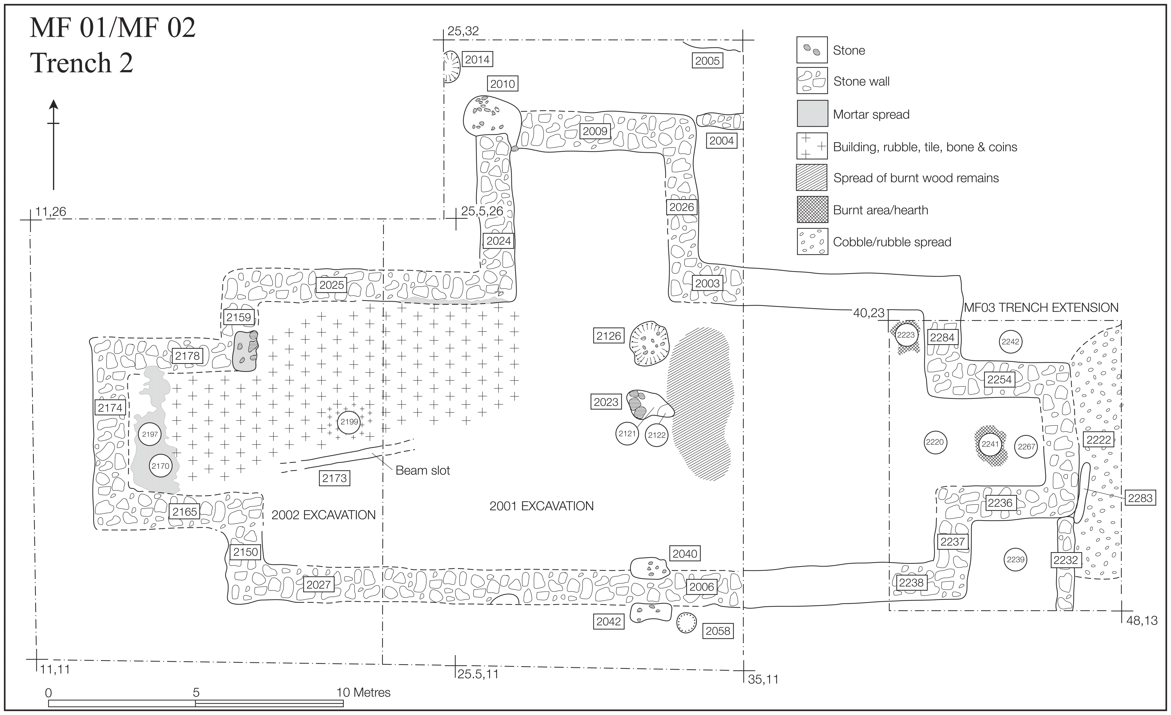
THE LATE ROMAN BUILDING (fig. 12)
This large building (c. 34 m long by 17 m wide) was located between the temple temenos and the semi-amphitheatre. The structure comprised a main central room with rectilinear annexes to the west, north and east. Inside the building little survives of the original phase apart from a limestone hearth. The coin evidence suggests that this earliest phase of building activity dates to c. a.d. 340. At a later date the building appears to have suffered from a fire. Levels relating to this burning event must have been cleared in the western part of the building before the deposition of a series of rubble and tile dumps, possibly rough working surfaces, which included high numbers of oyster shells, animal bones, nails and coins. Similar deposits were not found in the eastern side of the building, so this seems to have been a restricted area of activity and may reflect which part of the building was still habitable or usable after the fire.
Plan of the late Roman building in Trench 2.

The purpose of this building has been a subject of debate, but the most frequent suggestion is that, at least in its original phase, it was a church. While its probable late date makes this a possibility, the building does not have the decisive architectural features, such as an apse, to make this a firm interpretation. The identification of rural churches from their architectural features alone, however, is not easy since they do not seem to have followed the basilical form associated with early urban churches, but rather were simple rectangular structures, which cannot be distinguished convincingly from other rural buildings.Footnote 58 The closest parallel for this building comes from Verulamium Insula IX, which had two rectangular annexes at the ends of its long axis, but the likelihood that this structure was a church is considered to be slight.Footnote 59
Possible churches on earlier Roman temple sites have been claimed at Lamyatt Beacon, Brean Down and Uley, but with quite limited evidence.Footnote 60 Furthermore, if they were indeed churches then they probably belong to the fifth to seventh centuries and post-date the end of the life of the temple on each site. The overlap in dates between coin evidence from the temple pathway and those from the Trench 2 building at Marcham, however, suggests that the two buildings were in use simultaneously and that worship at the temple persisted into the fourth (and possibly fifth) century. Although Christianity and paganism seem to have co-existed, though not necessarily comfortably, in Britain for a long time (as evidenced, for example, by the fourth-century lead tablet from Bath, which refers to the thief as being either pagan or Christian), it would seem that it may have been necessary for them to be spatially segregated, as suggested by the cemetery evidence.Footnote 61
The small finds assemblage from the building may shed some light on its identification. Two-thirds of the assemblage comprised coins (687), which, so far, make up over 40 per cent of the total coin assemblage from the site. A large proportion of the assemblage comprised very small Fel Temp Reparatio imitations, which may have derived from a scattered hoard. High levels of coin deposition on temple sites in the fourth century, particularly Fel Temp Reparatio issues, have been used to prove that paganism was still strong in Britain after the official conversion to Christianity (post-a.d. 313), for example at Lowbury Hill, Brean Down, Lamyatt Beacon, Lydney, Uley and Woodeaton.Footnote 62 As well as coins, there were also significant numbers of copper-alloy and worked-bone objects, which make up a similar proportion of the overall copper-alloy and worked-bone object assemblages to those in Trench 18. This pattern of deposition points strongly to some ritual use for the building as an ancillary shrine to the main temple.
LATE ROMAN AND SAXON ACTIVITY ASSOCIATED WITH THE SEMI-AMPHITHEATRE
Activity inside the arena must have come to an end when the drain went out of use. A series of irregularly-shaped, linear features seems to have cut through the sand deposits on a north-west–south-east-alignment (fig. 7). These were probably natural water channels, which indicates that during episodes of heavy rain, the arena was now subject to large volumes of surface water, which was no longer being carried away by the drains. These flooding events appear to have led to the structure becoming boggy as marked by the deposition of thick clay deposits that were very rich in artefacts; this may suggest that the arena was being used for the dumping of rubbish.
Before the drain went out of use the function of the arena seems to have changed and various structures and other features such as a pit, post-holes and a beam-slot appeared inside, mostly concentrated to the east of the central area. Some of the stone surfaces lying to the south of the beam-slot seemed to comprise stones robbed from the arena wall as well as smaller cobbles, which must have formed rough working surfaces. A wooden stake, which was probably associated with these surfaces and was driven into the natural clay, has been radiocarbon dated to the middle Saxon period (1360±50 b.p.; cal a.d. 610–720 + cal a.d. 740–70 at two standard deviations (Beta – 228366)). This extends activity in the arena significantly later than had previously been assumed. It is hoped that further excavation will be undertaken in this area to clarify the nature of this activity and the length of its duration.
At some point in the late Roman period or later a group of eight burials, all on an east–west alignment, were placed at the eastern cardinal point of the semi-amphitheatre in the modified break through the bank (fig. 9). The burials seemed to form a discrete group and it is possible that they were interred in this location to mark the closure of the arena as a functioning monument. The absence of any grave goods and their orientation may indicate that these people were Christian, as has been suggested for a group of burials at Queensford Farm (Queenford Mill), Dorchester.Footnote 63 Two of the skeletons have been radiocarbon dated to 1652 ± 24 b.p. (OxA-17654: a.d. 332–435 (95.4% probability)) and 1702 ± 24 b.p. (OxA-17655: a.d. 315–409 (95.4% probability)), which indicates that the structure or at least the eastern entrance went out of use in the fourth to early fifth centuries a.d. Two of the skeletons had congenital abnormalities (spina bifida occulta) suggesting that this was a family group. Also, another of the skeletons had an abnormal bone formation in their auditory canal, which would have resulted in deafness and facial palsy. It may be for these reasons that this family group was chosen specially to be buried here rather than in the nearby late Roman and Saxon cemeteries located 150 m north-west of the temple, where over 300 inhumations and cremations have been found.Footnote 64
CONTINUITY AND RELIGIOUS PRACTICE AT MARCHAM
Study of the complex at Marcham has allowed several aspects of continuity to come to the fore. In terms of the on-going debate over the degree of continuity between the temple and the earlier Iron Age structures, it would seem that several earlier features persisted into the early Roman landscape. A conscious decision was taken in the Roman period to acknowledge and commemorate these vestiges of the past by choosing to focus religious activity, in the form of both structures (the shrine in Trench 36 and the ‘rotunda’) and deposition (the favissa-like pit), in the same area. While this does not provide a definitive answer as to whether the Iron Age activity in that area was also ritual, it does suggest strongly that the site still held a high degree of importance in the Roman period, which conceivably may have been the result of an earlier ritual focus.
Three elements and activities seem to have been important on the site in the Roman period: water, feasting, and votive deposition. Water, and its manipulation, appears to have been a deciding factor in the choice of site for the semi-amphitheatre. It was also a focus of depositional activity as part of the ritual associated with the semi-amphitheatre. Secondly, preliminary analysis of the vessel glass, pottery and animal bone suggests that feasting was a significant component of the ritual in the temenos area. This combination of water and feasting seems to have been encapsulated in a new formalised architectural context: a temple and semi-amphitheatre complex. Key questions here are: where do these buildings originate and why were they adopted here? The choice of building and their combination appears to have been one that was made in Gaul and then moved into Britain where they are found at sites such as Marcham, Verulamium (theatre-amphitheatre and temple) and Gosbecks (theatre and temple).Footnote 65 The reasons behind the choice in Gaul and how and why they moved into Britain merit further research.
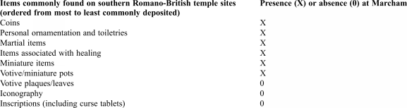
Although none of the items found so far seems to give an explicit indication of what the prevalent cult might have been at Marcham, preliminary analysis of the finds from the 2001–6 excavations does give some indication about the depositional activities on the site. The concentration of coins in the temenos area, for example, contrasts strongly with the density of personal ornaments on the approach to the semi-amphitheatre. These are patterns which deserve further exploration, for they may reveal and contribute to a clearer picture of depositional activity at rural religious sanctuaries in Britain. The small finds assemblages from Marcham are broadly similar to those from other Romano-British temple sites in southern Britain (Table 1). A. Smith's analysis of these sites has shown that coins were the most commonly deposited items of personal worship, followed by jewellery and other personal items, with martial items only being found in very small numbers.Footnote 66
THE PRESENCE (X) OR ABSENCE (0) AT MARCHAM OF ITEMS COMMONLY FOUND ON SOUTHERN ROMANO-BRITISH TEMPLE SITES

At Marcham coins (spanning the first to fourth centuries, but mostly fourth century) were the most common find, followed by bone and metal pins (mostly hairpins), finger-rings, bracelet fragments and fittings. In lesser, but still significant, amounts were: brooches (second to early third century), toilet implements (tweezers, nail cleaners etc.) and medical/toilet articles (spoon probes, ligulae, spatulas etc.). There were also small numbers of counters, alphabet letters, miniature tools and weapons and other martial objects, such as scale armour. No classical iconography, votive plaques or inscriptions have yet been found at Marcham. Further analysis of these differences may open ways of understanding the nature of earlier religious practice in the area and how flexible elements of that religion were to adaptation and change. The relative dearth of anthropomorphic images in Celtic art, for example, may be indicative of some form of taboo against representing deities in man's image. The unwillingness to change this practice at Marcham and in other areas of Britain can be seen then as a way of abstaining from certain forms of Roman religious practice and expressing discrepant identities.Footnote 67
Overall the excavations at Marcham are showing that continuity need not be directly continuous. The picture presented here of the site shows the persistence of behaviour where certain elements of ritual activity continue over long periods of time, yet also its malleability, where it can take on new architectural contexts.
ACKNOWLEDGEMENTS
Special thanks to Will and Janey Cumber for endless and varied support. Thanks also to John Duffield and Anne and Trevor Mumby for logistical support. The excavations have been successful owing to the hardwork and dedication of the supervisory and excavation teams to whom thanks must be extended. Funding was provided by the Roman Research Trust, the Cumber Family Trust, and Oxford University. Paul Booth and Alex Smith kindly read earlier drafts of this report and made useful suggestions and amendments, as did the anonymous referees. The illustrations were prepared and compiled by Mike Athanson and Alison Wilkins.