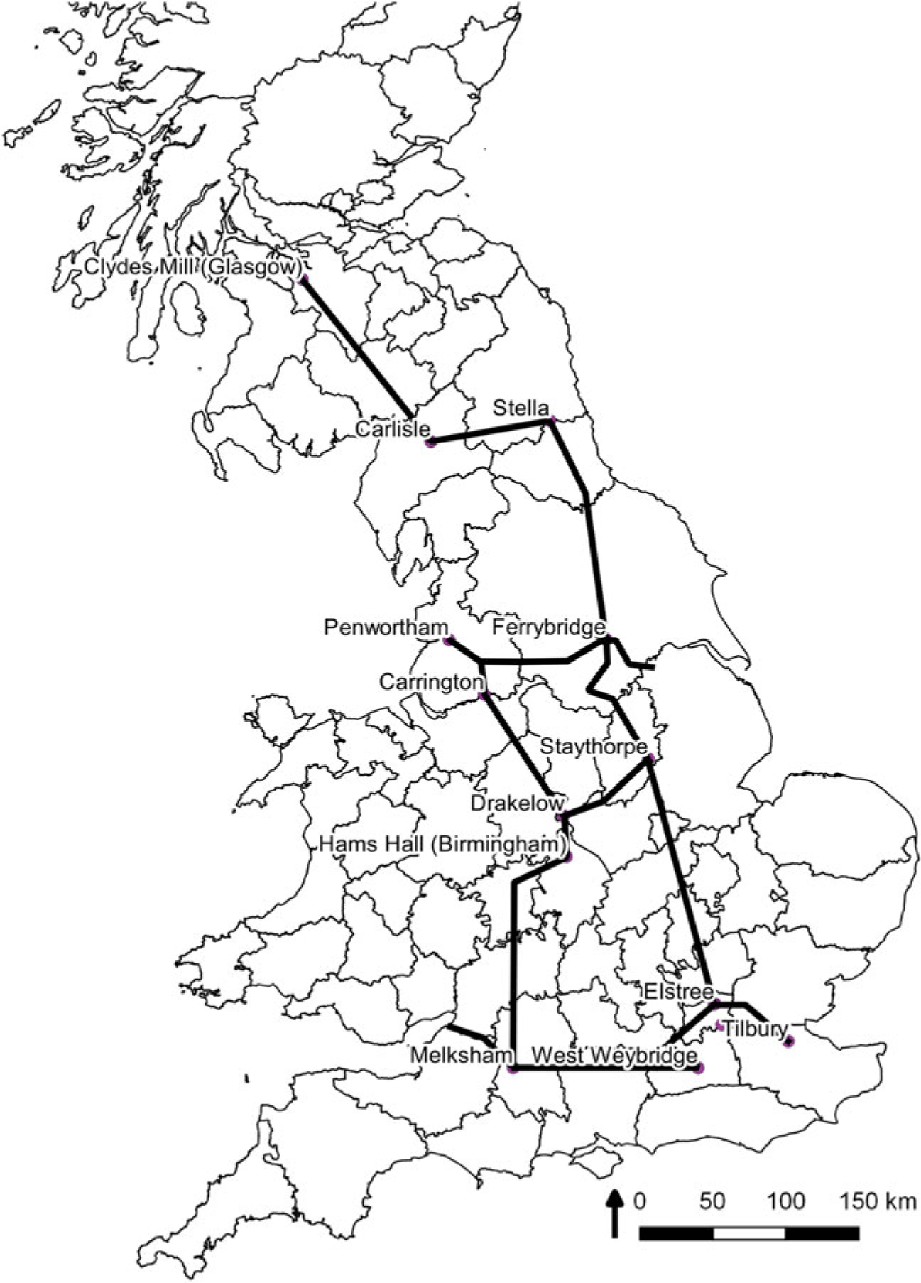



A ‘Super Grid’ of high-voltage power lines transformed the landscapes of Britain from 1953 onwards. By the late 1940s, the 132 kiloVolt (kV) lines of the old network were inadequate to cope with increasing domestic and industrial demand. Calls by politicians for the electrification of rural areas to improve agricultural productivity also convinced the electricity industry and the government of the necessity to modernise.Footnote 1 The nationalised British Electricity Authority (BEA) proposed a new electricity distribution network. The Super Grid consisted of 1,150 miles of 275 kV power lines carried by 136-feet-high steel pylons. The scheme would cost fifty-two million pounds over ten years and was designed to strengthen the north to south interconnections of the existing National Grid. The BEA also aimed to shift reliance on London for electricity generation to new power stations to be built nearer to the cheaper coal fields in Yorkshire and the East Midlands.Footnote 2 The first section of line, a forty-mile stretch linking Staythorpe near Newark, Nottinghamshire, to West Melton near Rotherham, South Yorkshire, was inaugurated in July 1953 (Figure 1).Footnote 3
Local authorities, preservationist groups, voluntary societies and residents raised appeals against the plans in many parts of the country. The government ministries of Fuel and Power and of Local Government conducted public inquiries to mediate the different interests and determine the final routes of the lines. The newly formed National Parks Commission (NPC) became involved, seeking to substitute underground cabling for pylons crossing areas under their remit including the Lake District and the Cotswolds. The Council for the Preservation of Rural England (CPRE) and its Scottish and Welsh equivalents led the preservationist case in the other regions. The debates involving the National Parks raised predictable rhetoric about their visual amenity value. But the opposition in other areas, notably the southern Pennines on the edge of industrial towns in Lancashire and West Yorkshire, offered more nuanced conceptions of the landscape and its uses by local inhabitants. This article examines evidence from the public inquiries and the correspondence of the CPRE and NPC.Footnote 4 It focuses particularly on the public inquiries into two sections of the Super Grid in the Lancashire Pennines, held at Bolton in November 1954 and Oldham in September 1959.Footnote 5 Opposition to pylons in these industrial areas reveals how definitions of landscape amenity were contested among different interests, and reflected significant differences of class, region and economy in postwar Britain. The preservationist case was not simply one of assessing the impact of pylons on the aesthetics of the countryside. Rather, the reaction against the Super Grid reflected broader concerns about the impact of a nationalised and centralised economy and planning system.
The resistance to the Super Grid proposals formed the second round of an ongoing battle fought by preservationists against the siting of the National Grid lines and hydro-electric power schemes from the 1930s.Footnote 6 Studies of the construction of the 1930s National Grid include celebratory accounts by the electricity authorities of the benefits of modernity, and positive explanations of the technical, organisational and financial aspects of the schemes.Footnote 7 Leslie Hannah’s comprehensive accounts of the electricity industry before and after nationalisation are more measured, but essentially focus on, as one of his titles specifies, the negotiations between Engineers, Managers and Politicians. Geographers have been mostly concerned with the impact of hydro-electric and nuclear power on the economy and the environment.Footnote 8 Bill Luckin’s Questions of Power, published in 1990, remains the main narrative of preservationist opposition during the interwar period. Luckin’s account was predicated on showing how rural preservationist groups and local authorities were ‘vanquished’ by ‘utilitarianism, progressivism and the inbuilt attractions of the new source of power’. He depicted a dichotomy between aggressively powerful ‘triumphalists’ among the electricity industry and a losing but more virtuous side of middle-class resistance to electrification in rural areas.Footnote 9 Later historians have questioned this portrayal of the two sides, including Luckin’s presumption of ‘the probable existence of a silent, working-class majority’, whom he argues were won over by the progressive rhetoric of the electricity bodies.Footnote 10
The debates of the 1950s drew heavily upon the rhetoric of landscape preservation developed before the Second World War.Footnote 11 But arguments both for and against the BEA’s plans were also composed in a new economic and political environment, the broader programme of modernisation instigated by the Labour government of 1945 and continued by the Conservative governments of the 1950s. Centralised authority was an integral part of this different context. Before nationalisation, the National Grid was made up of 569 small electricity companies, with local authority-run companies accounting for two thirds of electricity sales. Under the 1947 Electricity Act, the transmission system and power stations came under a new centralised body, the BEA, while distribution and sales were assigned to fourteen Area Electricity Boards, appointed by the Minister for Power and Fuel. The Conservative government of 1951 did not regard a return to industry pre-nationalisation as practical and favoured modernisation, although the next ministry of 1955 moved towards decentralising some of the BEA’s powers in the 1957 Electricity Act.Footnote 12
This article shows that in the 1950s, the electricity companies and the Ministry for Fuel and Power faced a difficult negotiation between localism and an aim for efficiency and value for public money. Moreover, the preservationist discourse could be pragmatic, encompassing working-class concerns about the impact of the large pylons, while reflecting a welcoming of some aspects of what could be termed ‘rural modernism’ within a particular framework of envisioning the landscape. David Matless’s study of the connections between the landscape and notions of Englishness has argued that not all cultural expressions of ruralism were conservative and nostalgic in simple terms, and that their visions for the landscape included acceptance of many elements of the modern. The wartime state economy promoted the growth of what Matless terms a ‘planner-preservationist vision of an ordered England’. A significant element of the rhetoric of preservation was concerned with ordering the landscape: physical improvements could be accepted as long as they contributed to keeping rural areas separate from urban districts.Footnote 13 This sense of ordering was also evident in two key pieces of legislation passed in 1947, which shaped the campaigns for and against the Super Grid: the Town and Country Planning Act and the National Parks Act. The legislation enabled local authorities to implement green belts in their development plans, following the principles espoused in Patrick Abercrombie’s Greater London Plan of 1944. Together with the formation of National Parks, the legislation set a new agenda for preservation integrated within the programmes of a modernising state.Footnote 14 The Town and Country Planning Act also removed planning authority powers from urban and rural district councils, designating them solely to the county councils and to county boroughs.Footnote 15 The public inquiries therefore raised questions about the remit of local authorities and their relationship with the central state. As we will see, some of the district councils’ opposition to the siting of pylons stemmed from anxiety that they had lost control over planning decisions to order their own environments.
The wealth of studies of postwar planning and the preservation movement emphasise the significance of green belt policy and the formation of National Parks, though few mention the impact of the Super Grid programme on issues of amenity and open space.Footnote 16 Following Matless, there is new interest in the technological and social impacts of electrification of rural Britain in the 1950s. Paul Brassley, Jeremy Burchardt and Karen Sayer’s recent edited collection suggests that electrification involved a deliberate programme of nation building, bringing previously isolated rural areas and Britain together through physical, technical and organisational connections.Footnote 17 John Sheail’s studies of the Central Electricity Authority remain the only examinations of the nationalised electricity industry’s negotiations with the National Parks Commission. Sheail shows how concern for the impact of pylons and power stations on the landscape was first raised by the formation of national preservation societies in 1926 to 1928, but that amenity did not become a key issue until the development of hydro-electric and nuclear power in the 1950s. He concentrates especially on how an amenity clause was eventually incorporated into legislation regulating the energy industries.Footnote 18 The NPC and Council for the Preservation of Rural Wales brought the question of amenity to ministers’ attention during the passage of the 1952 and 1955 North Wales Hydro-Electric Power bills. The NPC’s lobbying of a group of sympathetic peers led by Lord Lucas of Chilworth led to the introduction of an amendment to the Electricity Bill of 1957, specifying that the generating and area boards should have ‘regard to the preservation of natural beauty and to landscape amenity’. In debate, Lucas drew attention to the section of the Super Grid from Fleet in Hampshire to the Drakelow power plant in Nottinghamshire. He advocated underground cabling, weighing up the increased cost against the destruction of ‘some of the most picturesque parts of England’.Footnote 19 The 1957 Electricity Act was thus the first major piece of legislation to include an amenity clause, section 37, which stated:
The Board in question, the Electricity Council and the Minister, having regard to the desirability of preserving natural beauty, of conserving flora, fauna and geological and physiographical features of special interest … shall each take into account any effect which the proposals would have on the natural beauty of the countryside or on any such flora, fauna, features, buildings or objects.Footnote 20
The insertion of the clause thereby gave a national statutory effect for the measures already implemented in the Highlands and North Wales. The amenity clause was then considered in further legislation covering coal and water from 1958 to 1963, and finally becoming a key element of the Countryside acts of 1967 and 1968.Footnote 21
I take Sheail’s studies as a starting point for a deeper investigation of differing attitudes to amenity in areas outside the National Parks. Though the first section from Nottinghamshire to South Yorkshire was received positively in the local press, the next section in Lancashire to be constructed was immediately met by appeals, which raise significant questions about the definition of amenity for both contemporaries’ and historians’ understandings of how landscape was viewed and integrated into policy. Section 37’s definition of ‘natural beauty of the countryside’ was framed within a conception of the picturesque vistas or the grandeur of the National Parks and Areas of Outstanding Natural Beauty. I emphasise the significance of the wider conception of amenity proposed by the Lancashire branch of the CPRE. The CPRE and municipal authorities framed amenity in broader terms relating as much to residents’ material and social uses of the landscape as well as its visual appearance, a definition that was not fully encompassed in what became the amenity clause in the legislation. The final section of this article shows how this contested definition of amenity raised frictions between the NPC and the CPRE around issues of class and regional identity, reflecting wider tensions between southern middle-class and northern working-class preservationist interests.
The Bolton inquiry
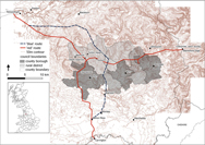
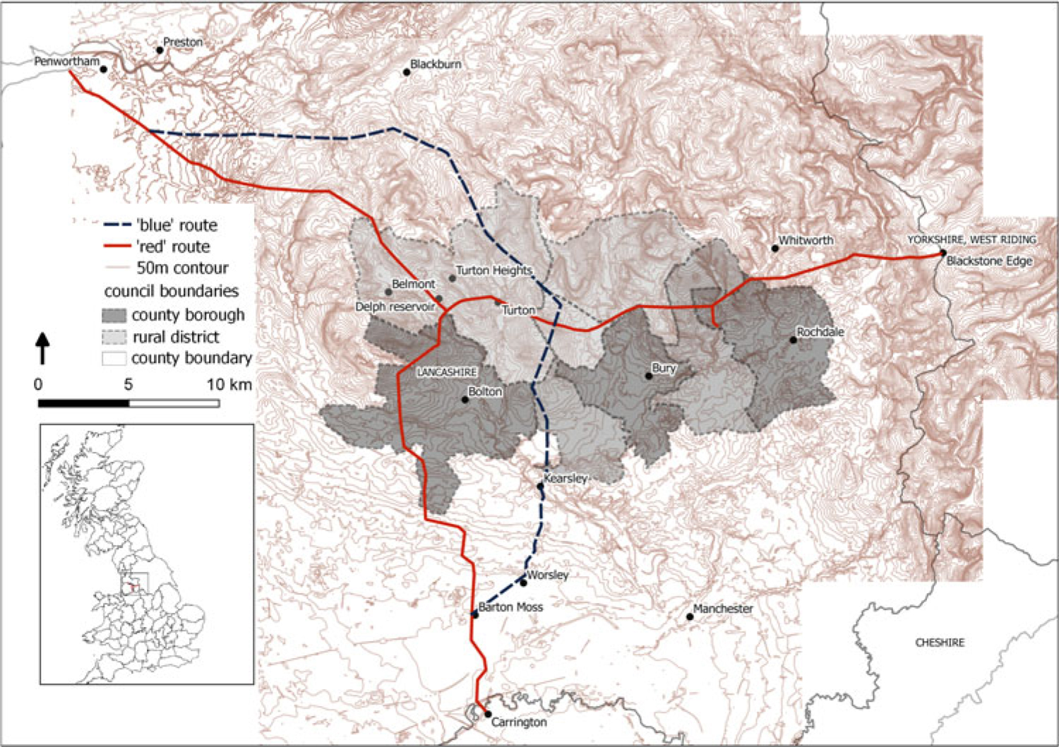
The section of the Super Grid from Blackstone Edge in the South Pennines on the border between Lancashire and West Yorkshire to Pennington on the Fylde coast covered fifty miles, stretching across the West Pennines and through the industrial region north of Manchester, with a spur heading southwards from Delph Reservoir in Egerton to Carrington on the Cheshire border (the ‘red route’: Figure 2). During the summer of 1953, local authorities discussed the proposals while the CPRE gathered and coordinated appeals from various interest groups and voluntary societies. Bolton County Borough Council, supported by Lancashire County Council, proposed an alternative line to the section running north to south from Penwortham to Barton Moss. This ‘blue’ route (see Figure 2) was situated entirely outside the borough, running through the mining districts of Kearsley, Turton and Worsley. By September 1953, an impasse was evident. A meeting of the planning officers had already anticipated that ‘Bolton intended to oppose any line through their area, that Worsley were almost certain to oppose the deviation suggested by Bolton, and that Darwen would certainly oppose a line between the town and Darwen Hill’.Footnote 22 Lancashire County Council refused to approve the proposed red route where it passed near Belmont. The other local authority objectors included six urban district councils forming the former townships around Bolton and on whose moors the line crossed; the county borough councils of Rochdale and Blackburn; and the metropolitan borough councils of Heywood and Radcliffe. Three other bodies put forward formal objections: the CPRE, Manchester Regional Hospital Board (as the line would cross a site for a new hospital in Lostock), and the only private landowner among the opposition, the Beaumont and Tempest estates, whose land at Bolton was affected.Footnote 23
Outline of the BEA scheme of the 275 kV Grid, 1953, proposed for completion in 1960.

Proposed 275 kV lines, ‘Red’ route and alternative ‘Blue’ route (1953–4). Shapefiles of contour lines from OS Open Data <https://www.ordnancesurvey.co.uk/opendatadownload/products.html#TERR50>, contains OS data © Crown copyright and database right (2017). County borough and rural district boundaries and proposed routes adapted from TNA MFQ 1/658, ‘Lancashire County Council. British Electricity Authority, North Western Division. Blackstone Edge to Penwortham, with branch to Carrington, series of maps’, 1954–5.
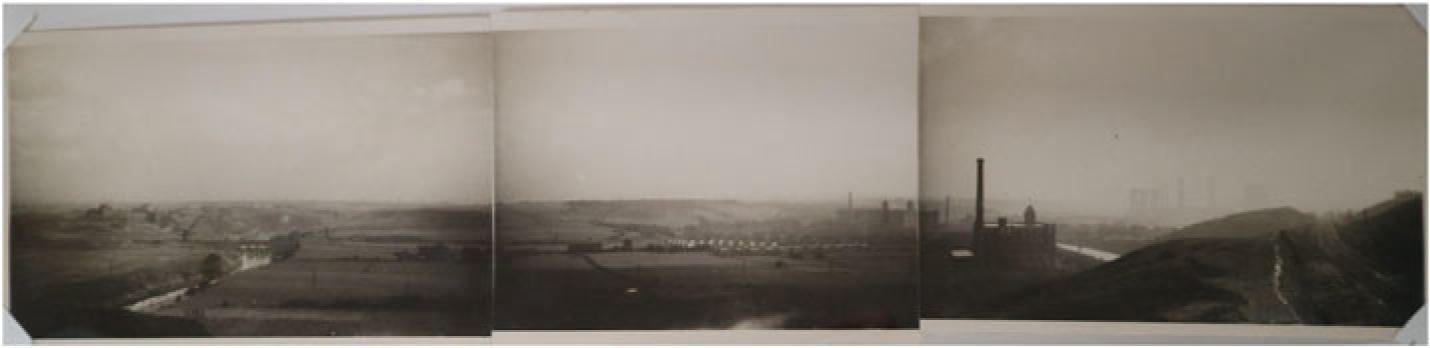
Photograph showing view of Kearsley Park, Lancashire. Evidence presented to the Bolton public inquiry, 2nd November 1954.

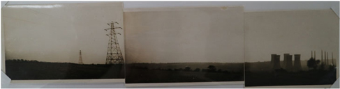
Photograph looking south from potential housing site north of Ringley, Lancashire. Evidence presented to the Bolton public inquiry, 2nd November 1954.

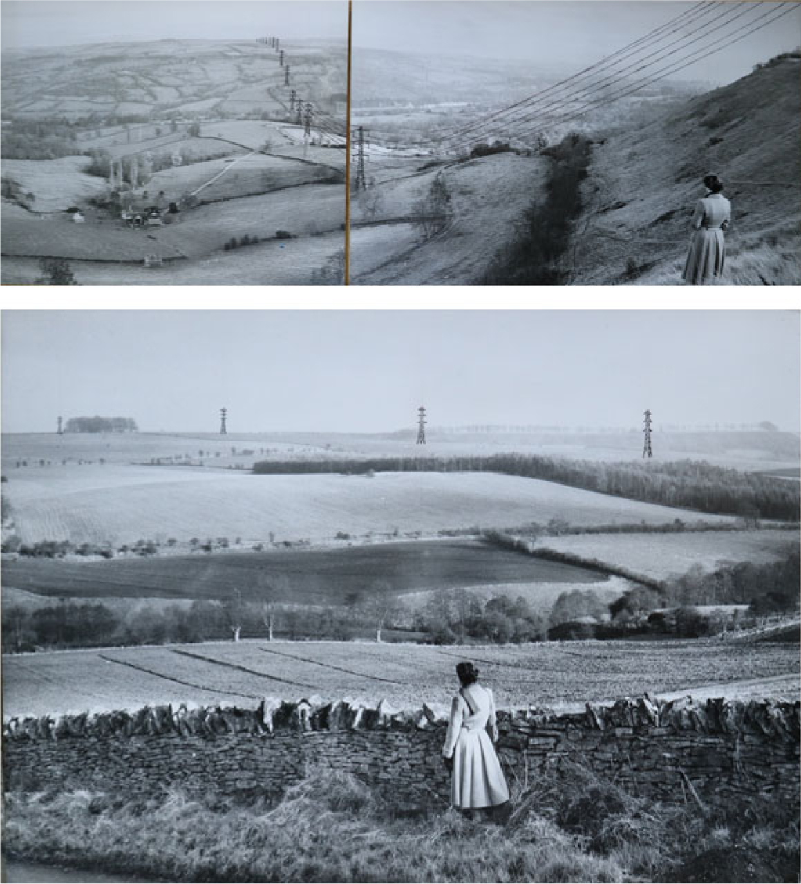
Views from Wistley Hill. Evidence presented to the Cheltenham public inquiry, 27th and 28th January 1954. The description noted, ‘This is one of the viewpoints for which Gloucestershire is celebrated.’

The public enquiry was held at Bolton town hall on 2nd November 1954. The objections raised by the authorities led to the chief engineers from the government ministries undertaking a physical inspection of the entire route at the end of the month.Footnote 24 The route to the west of Bolton was rejected and a version of the ‘red’ route, only slightly altered, was approved by the ministries. Protracted opposition from the councils of Kearsley, Little Lever and Radcliffe led to another hearing at Bolton in December 1955. The chief engineer for the Ministry of Fuel and Power overturned the objections, and construction began soon afterwards.Footnote 25
Amenity was the central issue contested by all parties. The legal representative of the BEA, Gerald Thesiger QC, set their interpretation of amenity and modernisation in his opening statement, evoking the specific context of improving the air quality and environment of industrial Lancashire: ‘If “dark satanic mills” are to be modernised, and if domestic hearths burning coal in open fireplaces are not to continue to pollute the atmosphere of heavily built up districts, there have got to be towers and lines for the transmission of electricity, and they have got to run either over open country, through which motorists drive, or through developed country in which people are living day by day.’Footnote 26 The Ministry of Power and Fuel consequently noted the novelty of the BEA introducing ‘the effect of atmospheric pollution as an argument in support of their case’.Footnote 27 Manchester City Council had already imposed a smokeless zone in 1946. The great smog of 1952 caused an increased death rate nationally, and in response, the Conservative government assembled the Beaver committee, whose final report was issued in November 1954, the same month as the Bolton public inquiry. It recommended a Clean Air Act (passed in 1956) that would move beyond controlling industrial sources to cover domestic smoke emissions.Footnote 28 The debates over the siting of power stations and the new lines thus occurred in the context of wider concern over the impact of national energy and industrial policies on both public health and the environment. Harold Willis, on behalf of Bolton Corporation, argued directly against Thesiger, with a contrasting view of how industry could be modernised to deal with the causes of pollution: ‘if the “dark satanic mills” described by Mr Thesiger are to be modernised and domestic hearths are not to continue to pollute the atmosphere, the only satanic things which remain in thirty years’ time will, perhaps, be Kearsley Power Station’.Footnote 29 The cultural trope of the ‘dark satanic mills’ of northern textile towns was thus a malleable term used by both sides in the context of postwar modernisation of industries and the improvement of the environment.
The next definition of amenity put forward was in terms of economic value. Bolton Council argued that an amenity was ‘a grand stretch of open country made immeasurably more valuable by its proximity to the centre of a drab industrial area’.Footnote 30 Its concerns related to its town development plan, which like many industrial towns’ postwar reconstruction plans, sought to expand agricultural, commercial and property development in assigned zones and designating parks and moorland areas as leisure sites and green belt. Bolton Council were particularly concerned that the ‘red’ route would ‘pass near to or over residential property along the whole of the route, which would result in the depreciation of value of the property’.Footnote 31 Representatives from neighbouring Tyldesley Urban District Council and Whitworth Rural District Council on the edge of Rochdale both argued the pylons would have a negative effect on the property value of their planned new council housing estates.Footnote 32 As studies of the London Green Belt have suggested, local councils prioritised housing their residents and slum clearance over the radical proposals for generous proportions of undeveloped open space envisaged by the wartime reconstruction plans.Footnote 33
The urban development proposals also raised issues among the local authorities about the extent of their planning powers more generally. An initial development plan had been drawn up for South Lancashire and North Cheshire by the Advisory Planning Committee in 1947. Some key themes of the preservation movement run through the document, including the importance of green belts and open spaces as both public amenities and as a physical and visual barrier between adjacent towns to limit urban sprawl and the ribbon development that Ian Nairn famously dubbed ‘subtopia’ a few years later.Footnote 34 The 1947 Town and Country Planning Act removed planning authority powers from urban and rural district councils, designating such powers to the county councils and to county boroughs.Footnote 35 Tensions between the new planning authorities and the district councils were evident in the appeals against the Super Grid. C. Glidewell of Turton Urban District Council was the most forthright in his opposition to the changes, claiming, ‘The private citizen, he said, not infrequently runs into planning trouble if he wants to put up a hen coop, but there are numerous cases which show that authorities, including nationalised industries, sometimes “get away with” things which quite clearly contravene major planning principles of the planning authority.’ The new status of nationalised industry, combined with an alleged centralising tendency among government planning, he argued, affected the outcomes and disadvantaged local authorities and private property.Footnote 36 Lord Lucas later reflected these concerns against the centralisation of planning in the parliamentary debates about the 1957 Electricity Bill, complaining that in the case of the line from Fleet to Drakelow, ‘It is the Hitler technique of grabbing one before approaching another, of swallowing up planning authorities one after another.’Footnote 37
There were also indications that district councils who had lost their planning powers attempted to use the public inquiry as an arena to voice their discontent. Ian Grimmitt, Chief Engineering Inspector for the Ministry of Fuel and Power, concluded in his report that ‘some of the Local Authority objections to the blue route were, I think, actuated by a feeling of resentment to the County Council proposing the blue line’.Footnote 38 Reginald Dart, the long-serving council surveyor for Turton, made a point of presenting his Town Plan for Turton of 1947 as evidence to the inquiry. In doing so, he was perhaps using the occasion as a way of asserting the planning powers that the district council had lost. Dart’s town plan included several illustrated pages lamenting the ‘detrimental effect’ of ungrouped wooden transmission poles and overhead wires, and advertisements on buildings stretching along the roads into the moors. Dart’s focus on the poor aesthetic quality of ribbon development and its ‘clutter’ echoed the Design and Industries’ Association 1930 yearbook, The Face of the Land, that Matless references as an example of rural modernism.Footnote 39 The preservationist case was not, however, united over who had control over planning decisions. Philip Barnes, secretary of the Lancashire branch of the CPRE concluded that the scheme would be more efficiently planned at county not local authority level to avoid such parochial conflicts, specifically referring to the county council’s new powers under the 1947 Act.Footnote 40
Amenity value: Natural beauty versus taskscape
The most contentious debate over amenity concerned its definition solely in terms of aesthetic appearance. As Sheail has shown, the amenity clause in the 1957 Electricity Act would use ‘natural beauty’ as the key descriptor, defined with reference to National Parks.Footnote 41 What features constituted natural beauty had long been contested. The BEA produced a memorandum in 1950, ‘Development of Electricity Supply in National Parks and Rural Areas’, to enable discussions over laying pylons across the newly designated regions. Though alarm was raised about the impact on the landscape, the ‘anti-electrical’ elements of the preservationist movements were in the minority; indeed, the anti-pylon campaigners did not object to underground cables. The NPC proposed cabling as a total solution for the National Parks. The BEA argued that pylons were preferable because the 1947 Electricity Act required them to ensure ‘economic and efficient distribution of supplies’ to customers, especially in rural areas.Footnote 42 The chairman of the NPC, Sir Patrick Duff, anticipated being ‘at loggerheads’ over the BEA’s use of the term ‘exceptional amenity’ in the document. The Lake District was used as a convenient but contested synecdoche for unspoiled natural beauty, even though in reality its appearance had been long shaped by human intervention and industry. In preparation for the NPC’s initial meeting with the BEA in November 1950, Duff noted that, ‘the exceptional amenities which they envisage are almost certainly not beautiful valleys of a mile or more in length, but quite limited incidents in the landscape’. He presumed that in the case of the Lake District, the BEA might ‘envisage avoiding a well known view of a lake being obstructed by an overhead line’ but would resist ‘the wider interpretation of the phrase to include relatively long distances in the centre of the Parks’ on grounds of cost.Footnote 43 The BEA’s response to Duff emphasised, as he predicted, the issue of economy and efficiency. But the issue also circled around the powers of the NPC. The BEA pasted in a section over the debated passages in the document that continued the ambiguities of definition and who had the right to determine what was an amenity, arguing it was a ‘matter of opinion’ related to the rarity of the visual appearance of each landscape.Footnote 44
But whereas at least the National Parks had some statutory recognition of their visual distinctiveness, defining amenity as aesthetic beauty in other regions was more controversial. The South and West Pennines were not included in the 1945 Dower Report that led to the 1947 National Parks Act. The region was too heavily populated and the moors had long been encroached upon by industrial and urban development, and thus did not have the same amenity value as other parts of the Pennines such as the Craven and Swaledale valleys in North Yorkshire.Footnote 45 Opposition therefore could not centre on the premise that pylons would wreck ‘unspoiled’ landscape (and indeed such a concept did not exist in reality in much of the National Parks as well), although the preservationists nevertheless made sure to defend the remaining beauty spots in more remote parts. In terms of the South and West Pennines, crucially, the amenity value was assessed in relation to the semi-industrial and urban areas they adjoined. Lancashire County Council’s statement of opposition was summed up in one line: ‘The proposal would be seriously injurious to the amenity of a fine expanse of valley and moorland scenery, especially valuable because of its proximity to the heavily populated area of South Lancashire.Footnote 46 The value of the moors, the councils and CPRE argued, was more about everyday access to fresh air and leisure as a relief from industrial and urban life, rather than preservation of pristine scenery for tourists to view on holiday. In this respect, this understanding of the local economic and social definition of amenity has echoes of Tim Ingold’s interpretation of the landscape as dwelling and ‘taskscape’. Attachment to the environment is material, local and quotidian more than representational and aesthetic: experiencing the landscape by living, using and working it rather than occasionally viewing it from afar.Footnote 47
The key site of contention was a fifteen-mile stretch of West Pennine moorland to the north of Bolton, an area of recreation for the urban industrial residents and motorists using the route as an alternative to the A6. One particular section was singled out: Belmont Road, an A-road that stretched north from Bolton through the district of Turton towards Darwen. The Lake District was used as the main comparator, interpreted differently by each side. The BEA’s constructional engineer, H. R. Schofield, stated, ‘the Belmont moorland is not in the same class as the Lake District, which he described as grand scenery’. Rather, it was ‘just ordinary open moorland country’ but would ‘not put it higher than that’. Schofield had lived in industrial areas around Manchester for twenty years, and his responses were telling of the contested materialities and attitudes to dwelling in the landscape. Debate continued onto whether beauty should be judged solely based on visual appearance from afar compared with use by walkers. Schofield contended that moorland was ‘awfully depressing in the winter when it is wet’, while his questioner, Harold Willis of Bolton Corporation, retorted that the value of scenery could not be judged in those terms as ramblers used the region in all weathers.Footnote 48 The central committee of the CPRE had already anticipated this argument. Prior to the inquiry, they notified the Ministry of Fuel and Power that they would be submitting photographic evidence of moorland panoramas in advance because, ‘in November it is quite possible that mist and fog will make any distant view impossible’.Footnote 49 Philip Barnes of the CPRE again queried the rhetoric that National Parks were representative of aesthetic standards. When challenged that, on a rainy day, the Belmont Road ‘presents rather a monotonous, grey appearance’, Barnes replied, in a characteristic show of wit, ‘Well, that applies to the Lake District and Scotland and anywhere else in certain weather conditions.’Footnote 50 He insisted that different standards of aesthetic amenity applied: ‘The protection of this Belmont area is as important as the protection of a more remote National Park, although the quality of the scenery may not be as high.’Footnote 51 The BEA nevertheless continued to argue that the countryside in the region was ‘very boring’, particularly when viewed from a car along the road. Schofield implied he ‘did not think the area to the north west of Bolton was really worth very much from the amenity standpoint’.Footnote 52 Their rhetoric therefore sought to weigh amenity solely in visual terms, while their opponents accused them of deliberately overlooking the wider impact created by the construction of pylons. C. Glidewell of Turton urban district council in turn criticised Schofield for stating ‘This area is not worth very much’, asserting, ‘that is the background to the [British Electricity] Authority’s approach to a problem which is almost wholly concerned with the subject of amenity’.Footnote 53
It is here we should turn to Philip Barnes, who played the principal role in leading the opposition at the Lancashire public inquiries. Barnes was a Sheffield rambler who had been active in the preservationist and right to roam movement in West Yorkshire and South Lancashire since the early 1930s, and was described in an obituary in 1965 as ‘one of [the] outstanding personalities’ of the CPRE.Footnote 54 The same language of ordering and separation that Matless identifies as characteristic of the preservation movement came through in Barnes’s appeal. He admitted that ‘the summit of Belmont is a featureless wilderness, but there are people who like wildernesses’. ‘Wilderness’ was a term that was debated in the context of the extent of human intervention in the natural environment of the national parks.Footnote 55 Architects such as Clough Williams-Ellis and town planners and preservationists, notably Patrick Abercrombie in his wartime reconstruction plans for Greater London, had depicted the green areas surrounding suburbia as ‘wilderness’ in desperate need of preservation and separation from urban sprawl, and their views were well publicised and influential.Footnote 56 But these attitudes were being modified as the greening ambition of postwar reconstruction plans were tempered by the realities of revised agendas of financial austerity, rising populations and a commitment to building mass housing schemes and modernising industry.Footnote 57 The impact of road improvements also influenced a preservationist rural modernism. Barnes also reiterated the position of the central committee of the CPRE that the view would be spoiled for motorists heading across the Belmont moorland on their way to the Lake District or the coast.Footnote 58 By 1950, the number of cars on British roads had recovered to prewar levels and would continue to rise rapidly during the decade. The preservationists reflected this development, as the typical leisure seeker in the countryside shifted from the rambler in the 1930s to the motorist in the 1950s. Investment in improving A-roads and their facilities, and planning for the new motorway system reflected the mood of bringing modernism to leisure motoring.Footnote 59 The Inspector for the Ministry of Housing and Local Government J. G. Birkett also mirrored this view, noting ‘the present popularity of sight seeing motorcoach tours coupled with the demand made to the motoring organisations for “scenic” routes prove that a very large number of people who travel by road do appreciate the country through which they pass’.Footnote 60
Barnes was acutely conscious of potential accusations against both the CPRE and local residents of Nimbyism. He put up a strong defence in his speech, against impressions that they were concerned ‘only about the views enjoyed by the passing motorist and not at all about the views from Lancashire’s back gardens and bay windows’. Notably also he blamed a long history of ‘woeful lack of planning’ that had ‘spoiled’ the Pennine valleys with the unregulated spread of factories and mines. This was a nostalgic plea to a world before Victorian industrialisation, but it was also a deep defence of locality in ‘dwelling’, defined and used by local inhabitants, rather than, as he argued, the more touristic aesthetic pleasures of the national parks.Footnote 61 Belmont Road was the touchstone of judgement, used, he argued, by local residents who ‘want to get away from the ugly industrial development and ribbons of houses’. It was both aesthetically and environmentally important as a barrier, and served as ‘Lancashire’s largest “lung” of open country’, for public health across the county.Footnote 62 Barnes evinced what Matless identified as the self-belief of preservationists, expressed in their arguments as binary contrasts of order and chaos, deployed not solely as polemic but more ‘to raise the stakes and to claim a clear and absolute authority over landscape’.Footnote 63 Barnes’s written statement to the enquiry was even more explicit about the CPRE’s negative opinion of the planning authorities. He argued that their disregard for ‘natural beauty’ now threatened to spread subtopia to the moors and hills ‘not only by these pylons but by monster radio and television masts’.Footnote 64 He was no doubt thinking of the police radio mast on Winter Hill directly overlooking the Belmont Road, which was soon to be joined by a new 140-metre high television transmitter in early 1956.Footnote 65
The local newspapers only reported the proceedings of the public inquiries, highlighting Barnes’s speeches, but without editorial comment or letters from local residents, so it is difficult to judge wider public opinion.Footnote 66 But the other witnesses to the enquiry at least reflected residents’ views, albeit self-selecting (and as discussed later, the timing and form of the enquiry meant working-class residents were represented through the CPRE rather than directly). Some witnesses were more overtly anti-pylon than Barnes. Reverend Hugh Gibson, the Congregationalist minister of Egerton, referred to the pylons and the overhead wires as ‘the barbed-wire sickness of modern life’. Harold Jones of Bolton spoke on behalf of five rambling clubs, highlighting their use of footpaths in the area and preference for the alternative ‘blue’ route that would take the pylons away from their section of ‘particularly picturesque’ countryside.Footnote 67 In a wider sense, the preservationist case rested more on a resistance to ribbon development than solely being about the pylons. The rhetoric and evidence presented by the CPRE’s representatives continued the stance of a ‘normative geography of distinct urbanity and rurality’ that Matless found in their interwar predecessors.Footnote 68
The difficulties of proving the alternative definition of amenity value in industrial areas was demonstrated by Barnes’s photographic and film evidence compared with photographs presented to the other inquiries. One photograph of Kearsley Park was annotated with the CPRE’s objection to the pylons crossing the horizon, even though the landscape featured Ringley Power Station in the distance, mill chimneys, canal and ribbon development of terraced houses along the road (Figure 3). The power station was opened in 1929 and expanded by 1949 at a capacity of twenty-four coal-burning boilers, and was situated in a mining district (Figure 4).Footnote 69 Differences about the extent of degradation in such environments were expressed among the interests opposed to the pylons. Lancashire County Council’s written statement noted, ‘Kearsley is already occupied by a large electricity generating station from which five existing 132 kV overhead lines lead out. The attitude of the Urban District Council is that enough of their amenities have already been sacrificed to the demands of electricity and that no more should be’.Footnote 70 The Bolton borough engineer by contrast noted that he did not object to the pylons being placed parallel to the existing 132 kV line south of Bolton because ‘this is a partly industrial area already spoiled by man-made things’.Footnote 71
The visual evidence at the public inquiries into the lines crossing National Parks were simpler to interpret and defend in terms of aesthetics. At the January 1954 inquiry at Cheltenham into the section proposed to cross the Cotswolds National Park in Gloucestershire, the area planning officer presented evocative photographs of Wistley Hill. The views of the rolling landscape were foregrounded by a solitary woman looking wistfully down towards Churn valley, upon which were superimposed the lines and pylons to scale (Figure 5).
Superimposing sketches of pylons and power stations onto photographs to demonstrate viewpoints was a common tactic in planning appeals, but was used for different means in the two public inquiries.Footnote 72 The Cotswolds pictures played on nostalgia, and illustrated how opposition was to do with the large scale of the pylons disrupting a particularly romantic vision of the rural landscape. The representative of Gloucestershire County Council notably expressed a rural modernist view about the pylons, ‘he did not think the towers in themselves were intrinsically ugly; on the contrary he would be inclined to agree that sited in the right place, in level country, preferably in a straight line, particularly where it conforms to industrial development, roads, canals and other straight lines of that kind, it might be not an objectionable feature’. Nevertheless, ‘his Council take a different view about it dragging its mammoth path over the slopes of the Cotswolds, where in their view it will be entirely out of harmony with the scene’.Footnote 73 The photographs were easy to reduce to the shorthand of the picturesque; indeed they played on the visual tropes of landscape painting. By contrast, Barnes’s pictures of Kearsley and Ringley concerned the extent of degradation already inflicted by industry and the 1930s National Grid. As with the binary placed between the Lake District and the Pennines, therefore, the broader definitions of amenity were much harder to infer from the photographs of the area around Kearsley, and could only be justified by the argument that pylons could only make the semi-industrial landscape worse.
Conflicts of class and region
By the time of the 1957 Electricity Act and Lucas’s amenity clause, preservationist attitudes against the Super Grid had hardened, and Nairn’s concept of subtopia became a common trope in both rural and industrial landscapes in letters to the editors of local newspapers.Footnote 74 The second public inquiry into the next section of the Super Grid in the southern Pennines was held at Oldham in September 1959. The body now known as the Central Electricity Authority proposed a route between Penwortham in the Ribble Valley across Blackstone Edge to Monk Fryston in the West Riding.Footnote 75 Philip Barnes again stood as the main voice of the local preservationists. His rhetoric was even more defensive, shaped by previous experience. Barnes drafted a statement to the inquiry that reflected on the lessons learned from the 1954 inquiry, notably the sense that the views of the CPRE and local residents had been ignored, that the CEA’s assurance of no further development was ‘worthless’, and that the ‘march of pylons’ implemented without effective consultation: ‘If all these lines go up Lancashire will have a total of some one hundred miles of Super Grid line and approximately five hundred “Blackpool towers” dotted over her countryside. How many it will have in fifty years’ time is anybody’s guess.’ Barnes’s rhetorical flourishes about the lack of preservation and green belt in the southern Pennines echoed some of Sylvia Crowe’s newly published concerns in The Landscape of Power about the need to separate countryside from town in the siting of pylons: ‘people are not going to place much value on such open country if it is only “Green” on some official map, and in fact is an ugly wirescape’.Footnote 76
The previous openness to discussion with the electricity authority had closed, a feeling exacerbated in areas not designated as green belts. The National Parks Commission’s actions in respect to allowing development moreover also exacerbated the aims of the CPRE. The CPRE central committee feared that the NPC would be toothless in the face of local authorities, landowners and commercial influence. As historians of the preservation movement have charted, Hugh Silkin’s initial plans for the Commission had envisaged much more coordinated and centralised planning powers, but in practice they were tempered or thwarted by antagonism with local authorities. County councils aggregated control over rural planning away from the central commission and local authorities failed to spend the funds required for proper implementation.Footnote 77 It is evident from the correspondence and minutes of the NPC that some of the weaknesses perceived by the CPRE were justified. For example, in 1950, the secretary of the central committee of the CPRE had requested that all applications for approving overhead lines should be referred directly to the NPC in the first instance. The chairman of the NPC’s electricity subcommittee Francis Ritchie replied that such a proposal was too time consuming administratively on its small number of staff but also ‘contrary to the spirit and intention’ of the commission to intrude on the responsibilities of the county and municipal planning bodies. Hence the NPC was perceived as impotent in the face of the planners, and it does seem from the minutes that proposals were often either referred to later meetings or ‘carefully watched’ rather than immediately acted upon.Footnote 78
The NPC’s unwillingness to provide concrete support for the Lancashire branch of the CPRE was a particular bone of contention, and Barnes’s interventions in relation to this issue highlighted divides exacerbated by class and region. In the consultations leading up to the Oldham inquiry in 1959, Barnes wrote to Sir Herbert Griffin, general secretary of the CPRE and a National Parks commissioner, of his disappointment at ‘how extremely unhelpful the National Parks Commission can be when dealing with landscapes which, although in easy reach of millions of people, cannot be labelled of “national” importance’. His resentment at the protection given to the National Parks over other areas inhabited and used by the working classes in northern England was direct and worth quoting in full as it reiterated the wider definition of amenity:
The Committee are astonished that the NPC are not objecting to this proposal but it is yet one more instance of the difficulty we find in convincing those who live in more salubrious parts of the country near these grim northern industrial areas. To anyone who attempts to assess the value of landscape solely on its intrinsic beauty, and not in relation to the people who enjoy it, the Medlock, Irwell and Tame valleys, and the bare Pennine slopes beyond them, will seem poor stuff compared to valleys like Borrowdale or Mountains like Snowdon. To the working folk of a score of Lancashire towns, however, they are of more immediate and constant value than the more famous places the majority will never see. The Branch would appeal to those who have to make the decision in this case to ignore any national standard of landscape beauty and to think instead of the ugliness of so much of industrial Lancashire and Yorkshire, to which these bits and pieces of our ‘Green Belt’ form a surprisingly attractive contrast.Footnote 79
The view expressed by the BEA in the previous public inquiry that the Pennine landscape ‘not being worth very much’ was, in the Lancashire branch of the CPRE’s view, replicated by the NPC. The notion of amenity was therefore very much situated in the context of class. Barnes voiced the suspicion that the NPC were concerned only with traditionally picturesque landscapes visited by leisured middle classes rather than the more ordinary landscapes relied on by the working classes as an escape from industrial pollution and work. The CPRE were acutely self-conscious of their reputation and its detractors. Hence Barnes stressed to the Bolton inquiry that they were ‘not a small group of enthusiasts’, but rather represented 180 local government bodies and 129 voluntary organisations in Lancashire, including the local branches of The Ramblers’ Association, cycling clubs, Bolton Field Naturalists’ Society and the Co-operative Holidays Association.Footnote 80 These groups had a large working-class membership, and therefore indicated a different interest to that presented by Luckin, who found the CPRE representing mainly middle-class interests in the 1930s.Footnote 81 For the 1959 Oldham inquiry, Barnes scoped a draft statement, emphasising that as well as representing the CPRE nationally, he also brought forward the views of the Peak District and Co-operative Holidays Association and the Manchester area of The Ramblers’ Association because ‘the officers of the two latter organisations are working people who find it extremely difficult to get away for two days in the middle of the week to sit through a long public inquiry’.Footnote 82 There was clearly a class undertone to the complaint here, suggesting the whole process was weighted against the CPRE as the BEA and government ministries represented the commercial and government interests and not local working-class residents.
Conclusion
The debates over the impact of the Super Grid expressed one just aspect of broader concerns about the pace and direction of social, political and economic change in 1950s Britain. The new pylons and power stations were material totems of modernisation, among motorways, New Towns and other developments integrating grand-scale urban technology into rural areas.Footnote 83 The modernisation programmes sought to centralise, nationalise and in some sense provide more egalitarian access to resources. But despite the initial utopianism displayed by planners and government ministers, none of these central policies succeeded in solving deeply engrained divisions of class and region in Britain. The processes of negotiation about the lines crucially exposed tensions among the different interests opposed to the Super Grid that are not always acknowledged in the standard literature of conservation and the Green Belt. National Parks were not national for everyone; definitions of standards of natural beauty excluded working-class and northern ideas about the value of landscape and its uses. Amenity had complex and debated definitions, shaped by environment, class and identity. These ambiguities and contradictions explain the position in which the various strands of the preservation movement found themselves. The Lancashire CPRE put up a strong case for amenity as a class issue, one that went beyond the aesthetic definition associated with the National Parks and the amenity clause. Local authorities also saw amenity as economic and social, with an eye to the new council estates that they were planning on the edge of their urban centres, albeit threaded through with the district councils’ resentment at the loss of their own planning powers. All sections of the opposition to the siting of the pylons shared a vision of zoning of the urban-rural divide. Their fears of a ‘wirescape’ accompanied by ribbon development and urban clutter spreading into the countryside involved less of a nostalgic and Nimbyist attitude identified by Luckin in his study of the 1930s, and shared more with the rural modernism that Matless found was typical among promoters of green belts and progressive rural policies in the 1950s.Footnote 84 The electricity authorities and Conservative government ministers’ priorities were for economic efficiency above all, though the eventual acceptance of the amenity clause in the 1957 legislation showed the impact of the debates on raising awareness and appreciation of the issue.
Current debates about the siting of wind farms and other energy sources share continuities as well as changes compared to the public inquiries over the Super Grid. One parallel is the rise, fall and rise again of the influence of local authorities in the planning process. Stephen Jay found how local planning authorities were marginalised after the electricity industry was privatised by the 1989 Electricity Act, but they have more recently increasingly reasserted involvement in energy planning.Footnote 85 In terms of public attitudes, the rise of health concerns around electromagnetism raised in the 1980s has marked the main change (whereas notions of potential impact on public health played no part in the 1950s debates). Nevertheless, studies of contemporary campaigns against pylons and wind turbines in Somerset, Yorkshire and North Wales indicate how visual amenity remains the major factor shaping popular opposition. Public understanding of the proposals moreover challenge the assumption ‘that citizens are selfish place-protectionists that lack the technical sophistication necessary to take a strategic viewpoint’, and that Nimbyism is inadequate as the sole explanation for opposition.Footnote 86 Interpretations of amenity continue to be debated in relation to emotional attachments to place, that is, how the landscape is an integral part of local identity through its uses for leisure and other everyday activities for residents as much as the benefits of maintaining a particular aesthetic for tourism. The Super Grid debates of the 1950s therefore parallel contemporary negotiations of difficult balance between recognition of the need for developing alternative energy sources and a defence of the rural landscape as a community resource.Footnote 87
Acknowledgements
Figures 3, 4 and 5 are reproduced with permission of The National Archives. I wish to thank The Museum of English Rural Life for their help with the CPRE archives, and Professor Matthew Kelly and Dr Iain Robertson for their advice on an earlier version of this article.