

On May 23, 1908, Frau Treppens, the proprietress of a Gasthaus near the agricultural estate Klein Ziethen contacted the governing council of Steglitz regarding an urgent concern about water damage. Steglitz was five kilometers south of Berlin's southern boundary; Klein Ziethen was twelve kilometers southeast of Steglitz. Writing on the advice of attorney Georg Hillman, Frau Treppens urgently inquired what the council was going to do about the water on her property, which had already caused “enormous damage.” Like many other property owners near Klein Ziethen, she had been battling water in her basement; for some this had been going on for two years. Frau Treppens inquired what steps Steglitz was taking against Rixdorf, another rapidly growing suburb, located on Berlin's southeast perimeter sixteen kilometers from Klein Ziethen.Footnote 1 Why was Frau Treppens turning to the officials of Steglitz, and why did she and her attorney assume that Steglitz and Rixdorf bore responsibility for her water-soaked cellar?
This was but one manifestation of multiple challenges that Steglitz, Rixdorf, and numerous other communities—not least of all, metropolitan Berlin—were struggling to resolve as a result of their technological answer to the problem of urban sewage. In a much acclaimed modernization program, the City of Berlin and several of its suburbs had constructed huge underground canals, designed to carry their sewage onto agricultural lands in sewage farms (Rieselfelder) beyond the parameters of the urban area. One of the ideas behind this massive undertaking was to return nitrogen-rich human waste to the land, where it could improve agriculture. Steglitz, following the model of Berlin closely, had purchased Klein Ziethen, and Rixdorf had acquired the fields of the neighboring Waßmannsdorf, both for the purposes of disposing of their sewage. The raised water table that caused Frau Treppens's cellar to flood was an unanticipated consequence, and there was unconfirmed suspicion that it was actually the drainage from Waßmannsdorf that was causing the flooding on Klein Ziethen.
This article explores Berlin's outward expansion in two intertwined developments of the last part of the nineteenth century. One is the reach to the green meadows of the countryside to solve the increasingly acute sanitation and environmental problem of human and animal waste. The other is the explosive urbanization of rural communities surrounding the city, as viewed from the single perspective of the former agricultural village of Steglitz. Connecting these two issues was Steglitz's own reach southward into the agrarian landscape to solve its sewage problem. These related processes of urban growth and sewage disposal entailed multiple layers of ecological transformation. Their story demonstrates ways in which humans' view of nature was changing during the nineteenth century and, consequently, ways in which people reengineered nature through the application of changing science and new technologies. New perceptions of dirt, disease, and health combined with notions of expansion, causing urban leaders to view their agrarian surroundings in new ways. There were both intended and unintended consequences. Berlin's colonization of the green meadows changed people's lives, often in ways that seem positive and logical to modern sensibilities. It also involved urban Berlin in agriculture, created a ring of human-made wetlands surrounding the city, and engendered challenges that had to be managed on an ongoing basis by a large bureaucracy of managers, scientists, engineers, and laborers.
Urbanizing Nature and the Problem of Human Waste in Berlin
In 1871, when Berlin suddenly traded its status from that of residential capital of Prussia to the governing seat of the new German Empire, it was a city of 826,937 inhabitants. Like many other nineteenth-century European cities, its population was exploding at a rate almost never experienced in human history.Footnote 2 Within a decade, Berlin's numbers had expanded by 270,000 inhabitants, and the growth continued to accelerate. Within the next five years, Berlin's population rose to nearly a million—995,470. By the end of the century, 1.9 million inhabitants resided in Berlin.
Two major developments were responsible for this growth. One was the rapid wave of industrialization that Germany was experiencing after mid-century. New sources of employment drew people by hundreds of thousands from the countryside to the cities. Berlin, well connected with other regions through good water transportation routes and a network of Germany's earliest railroads, and enjoying an increasing reputation as a cultural and political center, was one of Germany's fastest growing industrial cities. The other factor was the Prussian agrarian reforms, initiated under the Stein and Hardenberg reform ministries of 1807–22, following Napoleonic defeats. These innovations had been gradually implemented but were largely completed by mid-century. They severed rural inhabitants' centuries-old ties to their village lands, driving many to seek new forms of livelihood in the city. The conjuncture of industrialization and agrarian change reinforced each another, and this was not coincidental. Reform-minded thinkers since the eighteenth century had envisioned the introduction of private property in the countryside as a stimulus for a market-driven, industrializing economy, as they had seen happen in Britain, and this was indeed taking place in Germany by the 1850s. In Berlin, textile, garment, tool making, heavy metal working, consumer goods manufacture, and chemical firms were expanding exponentially.Footnote 3
In 1861, to accommodate its ballooning population, Berlin had expanded its area significantly beyond the eighteenth-century customs walls, which had kept the city separate from the countryside since the 1730s. After annexation of several suburban communities—Moabit and Wedding in the north and parts of the fields of Schöneberg, Tempelhof, and Rixdorf in the south—the old walls and gates came down (with the exception of the neo-classical Brandenburg Gate, retained for symbolic purposes). This annexation increased the municipal space by seventy percent, from an area of 3,511 to 5,923 hectares (13.6 square miles to 22.9 square miles).Footnote 4 With a population density of 36,000 people per square mile in 1871, Berlin was one of Europe's most overcrowded industrial cities.
To accommodate the newly acquired areas and to project future growth rationally, James Hobrecht, director of the Prussian Planning and Building Department, headed the commission that developed a comprehensive growth plan for the city. The “Hobrecht Plan,” drafted in 1860, was officially adopted in 1862. Sometimes compared to Baron Haussmann's famous modernization scheme of Paris, it envisioned wide boulevards that would accommodate military and commercial needs. Hobrecht and his colleagues conceptualized rectangular and pentagon-shaped blocks of five-story apartment buildings with large courtyards that would facilitate air circulation and open living spaces to sunlight, thus escaping the overpowering air pollution infamous in industrializing cities. Like urban planners everywhere in his time, Hobrecht sought to restore to citizens the “air and light” that had seemed so missing in the city landscape. He included green spaces in his plan, including planted squares and strips in the center of boulevards. He supported what he understood as Berlin's integration of social classes, in comparison with English cities in which working-class neighborhoods were ghettoized and separated from those of the well-to-do citizens. Hobrecht favored buildings designed so that the apartments with the highest rental rates were located in the first level above the ground floor in order to attract more affluent tenants. Decreasingly expensive accommodations would be constructed at each higher and lower level in the buildings to accommodate less well-off tenants.Footnote 5 Like Haussmann's plan, Hobrecht's may also have had the goal of making the city less susceptible to revolution by eliminating narrow streets that invited the construction of barricades. Berlin's violent days of 1848 were still fresh in the memory of Prussian and Berlin leaders.
Hobrecht lacked the unconditional authority that Napoleon III granted Haussmann to carry out central planning. The designer of Paris enjoyed the power to demolish working-class districts to make way for new street and building construction, regardless of the concerns of property owners and neighborhood inhabitants. In Berlin, in contrast, a coalition of real estate entrepreneurs and railroad companies limited both the conceptualization and the implementation of the Hobrecht Plan. Berlin landowners maintained control over their properties, and the railroads presided over land-based transportation routes. Some liberal critics complained that Hobrecht planned an urbanization and commercialization of pastoral landscapes beyond the 1861 city limits. Amid these complicating circumstances, the Hobrecht Plan, legally Berlin's master plan until 1919, remained in part unrealized. Berlin's slums and impoverished neighborhoods mushroomed as industry and population expanded. (Haussmann's Paris also produced ghettoized slums.) The preferred style of real estate developers was the five-story Mietskaserne (rental barracks), but they often crowded cheap buildings into courtyards behind the main apartment dwellings, creating facades of respectability facing the streets, with out-of-sight substandard living environments for poorer tenants. These conditions contravened Hobrecht's envisioned openness to air and light in working-class living environments. Berlin's burgeoning population increasingly lived in miserable conditions that critics labeled “Manchesterism,” in reference to the early industrial British city whose crude, unsanitary, crowded slums had been made infamous by Friedrich Engels. Working-class households lived crowded into one- and two-room apartments; multiple families often inhabited the same space. Basement apartments were notoriously damp. The 1867 census counted many examples of twelve to twenty people living in apartments of one heated room. As many as 24,000 households rented their beds to others who worked different shifts.Footnote 6
Thus with a population concentration seldom experienced in human history, except in other industrializing cities, Berlin faced extreme environmental and health crises. Removing vegetation and sealing the earth with paving stones and buildings prevented the ground from absorbing rainwater, causing increasing waves of flooding and erosion. The density of living conditions resulted in excesses of human waste that could not be accommodated by traditional means. Animals in the city added to the problem. In 1870, within Berlin's city limits, there were 27,005 horses, 2,874 cows, 2,370 pigs, 726 sheep, and 24,949 dogs.Footnote 7 Manure littered the streets, roads, green spaces, and courtyards. Berliners were living increasingly in filth.
This was not a new problem. Medieval and early modern cities were famous for muck, slime, and odors. Europeans before the end of the nineteenth century endured smells and substances that later generations would find intolerable. The mounting intensity of the problems of waste and drainage in nineteenth-century Berlin, however, was creating new and different kinds of phenomena, as it was in other European urban areas.
Until the advent of industrial cities, humans generally used nature for water and waste removal. In villages, towns, and cities, rainwater flowed downhill to the lowest point—into streams, ponds, and rivers—and followed a natural course, washing away unwanted material as it flowed. Hydraulic engineering, including drainage projects and channeling of water, often enhanced these processes, but generally in coordination with the earth's curvatures. Organic decomposition was the natural process that cleansed settled areas by returning animal and plant matter to the soil as fertilizer. Preindustrial cities often possessed agricultural fields and meadows outside their walls and could recycle organic material on their farmlands. Urban pigs consumed kitchen wastes, recycling them into meat for human consumption, and urban gardens benefited from composted materials to enhance food production for people. Night soil collectors, common figures in cities, carried away the contents of outhouses and cesspits to be used in agriculture. There was relatively little nonbiological waste. People repaired and reused tools and leather items. Rag collectors took away clothing that was too threadbare to be repaired, and paper makers recaptured the fibers as the main ingredient for their product.Footnote 8
Changing conditions in Berlin were putting strains on these ancient practices. Agriculture and horticulture were still part of urban life, as evidenced in Theodor Fontane's realist novel, Irrungen, Wirrungen, set in the 1870s. Fontane's characters, Herr and Frau Dörr, made their modest living from their gardening business at the corner of Kurfürstendam and Kurfürstenstrasse, an intersection of high traffic at the edge of Berlin's 1861 annexed territory. Fontane, writing his novel in the late 1880s, called to readers' attention conditions that they might remember but that were disappearing, as cobblestones and buildings claimed more and more of Berlin's surface and made operations such as the Dörrs' less possible.Footnote 9
Until the 1870s the major way of dealing with drainage and waste in Berlin was to channel liquids toward the Spree River through open stone-lined gutters (Rinnsteine) on the sides of streets. These were approximately fifty centimeters (twenty inches) wide and sixty centimeters (twenty-four inches) deep. In front of buildings, small footbridges that rested on metal strips allowed pedestrians to cross the trenches. These gutters drained away rainwater, but households without gardens for composting or animals that consumed kitchen waste also commonly dumped their domestic refuse into these gutters in front of their houses. With Berlin's gradual gradient and an increasingly dense population, the ditches often became blocked, causing waste food, garbage, manure, animal carcasses, and even human waste to pile up, producing decaying matter that released foul odors. The stench became stronger when workmen cleaned out blockages. The floors of the ditches were not sealed, so that polluted liquids seeped into the soil. In winter the gutters often froze, causing more backups and slippery surfaces that made it dangerous to walk on the streets.Footnote 10
The open gutters were not intended to carry away human excrement. This was normally confined to cesspits in courtyards, which were emptied periodically by haulers who took the contents to agricultural areas. There were also “night-bucket women” who carried their contents to the river and dumped it. Despite regulations that Berlin cesspits be sealed and covered, many had permeable walls and bases, so that liquids from them seeped into the ground. The wagons that carried the contents out of the city were also often not sealed, so that they leaked filthy matter onto the streets and courtyards. In the 1860s Dr. Friedrich Behrend, the editor of a public health journal, described the conditions of his childhood in Berlin, which, he said, “still exist for the most part today”:
The emptying of sludge and refuse from the latrines . . . and carrying the filth away—the way it is done now in Berlin is awful. During the night in which this procedure occurs, all of the doors and windows of inhabited rooms have to be tightly closed. The stink that arises is so strong that it nevertheless finds its way in, and people's noses begin to sting, and it is not uncommon that sickness and vomiting occur. Anyone who is able to escape the house during this time runs away and stays somewhere else.Footnote 11
The task of hauling away the privy and cesspit contents was overwhelming the infrastructure. As the amount steadily grew, supply outstripped demand, farmers paid ever-decreasing prices, and the business of hauling it became unsustainable. The famous Berlin medical scientist and passionate public health pioneer, Rudolf Virchow, described the crisis:
It is well known that in recent times in our city all of the haulers, regardless of how much they were praised when they began their businesses, have gone slowly or quickly bankrupt. The main reason is always the same: lack of a market [for the material]. Either the farmers did not want to take the dung at all or they would not pay enough for it. Thus it came about that the waste haulers used any opportunity to get rid of the contents of their wagons and barrels. Still in fresh memory is an incident that occurred very close to the city, when whole wagonloads of fecal material were dumped in the night on the paths of the Tiergarten. It is the same in other cities.Footnote 12
Berlin's Search for a Solution
Not only the odor and distastefulness of the situation, but also changing scientific understandings of medicine, drove contemporaries to conceptualize new understandings of urban waste and to struggle with methods to deal with it. Scientists all over Europe were beginning to develop new understandings about the transmission of diseases. There was great concern about occurrences of cholera, typhoid fever, tuberculosis, diphtheria, and dysentery. Especially Asian cholera produced fear among the public. This gruesome disease first appeared in Europe in 1831, and widespread epidemics recurred approximately every fifteen years. In Berlin during the 1831 epidemic, 1,423 people died of cholera, in 1849 there were 3,552 deaths from the disease, and in 1866 it claimed 5,457 lives. Of those infected, the chances of survival were less than four out of ten. There were ongoing smaller outbreaks in the intervening years, which continually fueled the panic.Footnote 13
The transmission of disease by germs was not yet understood and would not be proven until Robert Koch and Louis Pasteur conducted successful experiments in the 1880s. During the 1830s eruptions, many doctors believed that cholera was communicated through contagion—infected individuals coming into bodily contact with others. Governments tried unsuccessfully to fight it with quarantine, closing off infected sections of cities. Other analysts attributed it to miasma, the theory that illnesses traveled by foul air, infecting those who breathed it. Some commentators associated the disease with moral failings and the perceived undisciplined life of working-class slum dwellers. Researchers worked furiously to pinpoint the causes of the disease. By the 1860s the German public health community had begun to accept the theory of the respected Munich health scientist, Max von Pettenkofer, who believed that cholera was not transmitted by person-to-person contact. His experiments led him to the conclusion that humans carried cholera from place to place, but not through physical contact between individuals. Instead, he reasoned, the soil became contaminated through human excreta, and the infection seeped into the groundwater. When the soil became saturated due to rain, the impurities rose to the surface and were released into the air, which then infected people. This was a variation of the miasma theory, but it placed new emphasis on excreta, soil, and water as transmitters of disease. No explanation was definitive, however, and the many hypotheses competed with one another. Although British public health reformer Edwin Chadwick demonstrated connections between unsanitary living conditions and disease, and physician John Snow demonstrated in 1854 a direct connection between polluted well water and cholera contagion, their work was not considered conclusive. Cholera's spread was a mystery, but increasingly the signs pointed to impure water as a critical element in the infection process.Footnote 14
Nineteenth-century government officials and medical scientists were increasingly concluding that the traditional natural processes of gravity, biodegradation, and recycling used to remove liquids and other unwanted material from the city had become unsustainable. A new method must be found, and the growing consensus pointed to an underground sewer system, “canalization,” as it was called.
With an increasing sense of urgency, and in absence of concrete plans on the part of the Berlin city council, the Prussian government appointed a commission of experts charged with the task of proposing a plan to resolve the city's filth problem. This council included James Hobrecht, Director of the Board of Public Works Eduard Wiebe, and civil engineer Ludwig Alexander Vietmeyer. After traveling to London, Hamburg, and Paris, the commission, led by Wiebe, proposed a sewer system modeled after London's, which came to be known as the “Wiebe Plan.”Footnote 15
Berlin was thus preparing to follow the path chosen by other large European cities. The 1850s had seen numerous great sewage engineering projects. London was pushed forward by the fears of cholera and by the fact that middle-class householders were installing water closets that eventually flushed their contents into the Thames and led to unbearable odors, “the Great Stink” arising from the river. This led to a major sewage project from 1858 to 1865, and other industrializing British cities followed in parallel fashion. Paris had had crude underground sewers even earlier, immortalized as the city's dark underground in Victor Hugo's Les Misérables, but their purpose was to syphon off excess rainwater, not human and household waste. A major part of Baron Haussmann's urban renewal was the creation of great new sewers, but Haussmann also envisioned them only as rainwater conduits. By the 1860s, under pressure from sanitation experts, the Parisian government began to use them for rinsing human waste out of the city. Hamburg had taken advantage of rebuilding after its “Great Fire of 1842” to construct a sewage system, placed into service in the 1850s. Hobrecht had overseen the construction of a sewer system in Stettin before coming to Berlin. Leipzig, Chemnitz, and Frankfurt am Main had plans in various stages of planning or construction.Footnote 16
There were many skeptics and opponents. Berlin officials were not entirely convinced that it was a governmental responsibility to remove waste. Organizations that represented agricultural interests complained that sewers would rob the land of a valuable fertilizer. Many proposed modernizing the existing system by replacing cesspits with sealed containers, which would be transported to the countryside. Some German cities were using this method.Footnote 17
Berlin medical experts, however, were largely united about the need for an urban sewer system, and their voices were strengthened by the recurrent health problems of the city. But they raised concerns about the Wiebe Plan for canalization of the city's sewage. Rudolf Virchow, the chief expert on the Prussian Royal Scientific Commission for Medical Affairs, was a leading voice in this discussion. Virchow was one of Berlin's most passionate, yet rigorously scientific, researchers on the subject. Since the 1840s when he collected data on both typhoid fever and cholera, he had been vigorous in seeking to discover the cause of epidemic disease. His approach to medicine was holistic, and he rejected the idea that the poor were responsible for bringing disease on themselves. He was interested in community health, and he collected extensive data that would contribute to an understanding of infant mortality. He produced volumes of scientific and public health papers on sanitation, health, and epidemiology. In 1859 he became a member of the Berlin City Council, which gave him a public forum in which to argue for improved sanitation in the city. Virchow's Scientific Commission was committed to the notion that the common diseases were “preventable, because they occur only when certain harmful substances related to human habitats affect the body.” They thus saw their objective as identifying those substances and keeping them away from people's dwelling places. The commission presented data documenting that inhabitants of basement apartments had a disproportionally high percentage of mortality. They linked this with high groundwater levels seeping into basements, which they attributed in part to Berlin's light, sandy soil. This raised the concern that the underground sewage canals of the Wiebe Plan would exacerbate this situation. The commission advocated excavating much deeper into the earth to place sewage canals so low that the floor of the canal, or the entire cavity, was immersed in the ground water, which they theorized would help dry the basements by draining excess moisture from them, rather than the wetness seeping in the other direction. They also pointed to the “unquestionable rise in the degradation of Berlin well water, which . . . produces suspicion of an increase in the introduction of substances originating from urine, excreta, and kitchen waste, even though definitive proof has yet to be supplied,” an additional reason for deeply set sewer canals. Virchow's research led him closer to Pettenkofer's theory of a link between groundwater, fecal contamination, and cholera, without, however, the emphasis on “bad air” or miasma. By 1868 he argued that “groundwater . . . is the necessary precondition for an epidemic, to a certain degree, as the locus of the germs of the disease.” Typically cautious in drawing scientific conclusions, however, he added that “a definite conclusion on this point cannot be reached until the cholera germ or cholera substance is actually identified.”Footnote 18 The lack of proof, however, should not stand in the way of swift action to construct a sewer system, the commission argued.
Virchow and his colleagues were in agreement with Wiebe's commission in proposing a massive and transformative engineering project, a network of underground channels that would remove human and other waste products from sight, take them out of the daily experience of citizens, and deposit them away from the city. Instead of using the earth's gradations and gravity's energy to remove unwanted material, their proposed sewer system would employ fossil-fuel energy to pump a continuous flow of water to wash away the unwanted material.
A precondition for sewers was a source of water with which to wash the flow of residue away. Berlin had installed a municipal piped waterworks, with construction begun in 1853 and completed in 1856. The purpose was not to provide household water for residences, but rather primarily to wash down the streets and drainage gutters, and to fight fires. The private British company that had built the system relied on paying customers to make a profit and thus had favored the wealthier areas of the city. The northern working-class neighborhoods were excluded. Some households where the water was provided canceled their cesspool haulers, assuming that they were no longer needed, thus putting greater amounts of excrement and other waste into the streets, worsening the problems. Some began to install water closets, which simply emptied into the street gutters.Footnote 19
The Prussia Medical Commission's greatest concern with the Wiebe Plan was the destination into which the sanitary canals would empty their contents. Sewage would be out of sight and away from human activity, but what should be its ultimate disposal place? The Wiebe commission planned that the pipes would empty into the Spree River. This was a design based on historical experience. The Spree had carried away Berlin's waste since the thirteenth-century founding of the original small fishing-trading settlements, Berlin-Cölln, on adjacent sandy banks of the river. The new sewers of London, Paris, Hamburg, Frankfurt, and many other cities led to the urban rivers. The Wiebe Plan called for discharge of sewage at Charlottenburg, “at a place behind the high embankment of the Hamburg railroad.” Virchow's commission objected to using the river as the depository of the sewage. The commissioners cited instances of contamination of the Thames and the Elbe below London and Hamburg. They predicted fish kills from pollution and pointed to health risks for those who navigated the rivers by boat. They refuted the claim that rivers with sewage would fertilize fields at times of flooding, pointing out that flooding is unmanageable and can result in stagnant water, killing crops, rather than nurturing them. Seeking a greater degree of control over the process of disposition and decomposition, they proposed “irrigation,” by which they meant using the sewage as fertilizer by distributing it in a planned and methodical way on agricultural lands. This new practice was being tried in in several locations in England, after cities there found their sewers were creating great outcry from downstream communities.Footnote 20
In raising the question of the destination of the sewage, Berlin joined a national debate—indeed an international one. Scientists, professional organizations, and public interest groups campaigned with competing positions. The German Association for Public Health (Deutscher Verein für öffentliche Gesundheitspflege), founded in 1863, focused its attention largely on the issue of cholera and typhoid fever. By 1873 this organization took a firm position in favor of emptying the refuse into rivers, believing this was the best means to have it carried far away from inhabited areas. The members professed belief in rivers' ability to clean themselves. A dissenting group, also made up largely of health professionals, the International Association against Pollution of Rivers, the Earth, and the Air (Internationaler Verein gegen Verunreinigung der Flüsse, des Bodens, und der Luft) declared its opposition to the plans that would “degrade our rivers into sewers and thus to damage the inalienable rights of riverside neighbors.” Presaging a late nineteenth-century conservation argument, they appealed—within just years after the founding of the German Empire—to the values of those who would preserve “German” nature by keeping the rivers pure. In addition they argued on economic grounds: human excrement was a valuable agricultural resource.Footnote 21
The ancient practice of using human excrement as fertilizer had taken on a scientific dimension as early as the 1830s when Justus Liebig of Gießen and French scientists Jean-Baptiste Dumas and Jean-Baptiste Boussingault described the key role of nitrogen as a plant nutrient. Liebig, known in Germany as the “father of agricultural chemistry,” at that time had opposed the installation of water closets and sewers on the grounds that they would waste valuable nitrogen that should be returned to the land. Scientists were, moreover, discovering ways in which nitrogen in streams robbed the water of oxygen and also negatively affected aquatic flora and fauna. This bolstered the arguments for engineered means of returning urban waste to the soil to capture its nutritional value. Proponents pointed to ancient and medieval European and Asian precedents. The new scientific construction of the problem sought to alter the conception of fecal material and urine as disease-causing substances to be removed from sight and mind. Instead, human excreta should be collected, channelized, filtered, and spread on fields to recapture the organic matter for fertilizer. The authority of modern science and technology could be applied hand in hand to recapture traditional ways in order to address the challenge of feeding a growing population. The new construction of the problem rested on a nature-to-nature recycling model. Justus Liebig, who frequently inserted himself in controversies and often changed his position, nevertheless provided a strong rationale with his assertion that one must give back to the soil that which one has taken from the soil.Footnote 22
The Prussian Royal Scientific Commission, led by Virchow, conducted an extensive three-year study to test their plans using all science available, including “geometric, engineering, and chemical research on soil, water, and mortality in various parts of the city.” They were aware of numerous functioning sewage farms in England, but they also knew that the primary emphasis there was agricultural. Virchow's group was highly motivated to achieve optimal sanitary results. They performed their tests on a former military field in Tempelhof, just south of Berlin. Using a three-horsepower steam engine, they pumped liquid sewage from the Königgrätzerstraße open gutter onto the fields. The commission published nine volumes of data. Virchow was delighted to report that Berlin's sandy soil absorbed all of the water applied to it, unlike in England, whose new sewage fields had always produced runoff because of heavier soil. “The absorptive capacity of this [Berlin] soil was most astounding.” Although they found chemical contaminants in the runoff, they did not conclude that these negated the experiments: “The soil itself was sufficient to clean the water physically and chemically [through oxidation].” Grass grew verdantly on the test field. Virchow and fellow scientists and engineers concluded unequivocally that the future for Berlin lay with sewage farms (Rieselfelder, “seepage fields”) and recommended a city-financed system with obligatory participation of all dwellings as soon as they could be connected to the water main. They predicted significantly increased agricultural yields, a solution to the sanitation problem, and a long-term cost savings to the city, despite enormous initial investments.Footnote 23
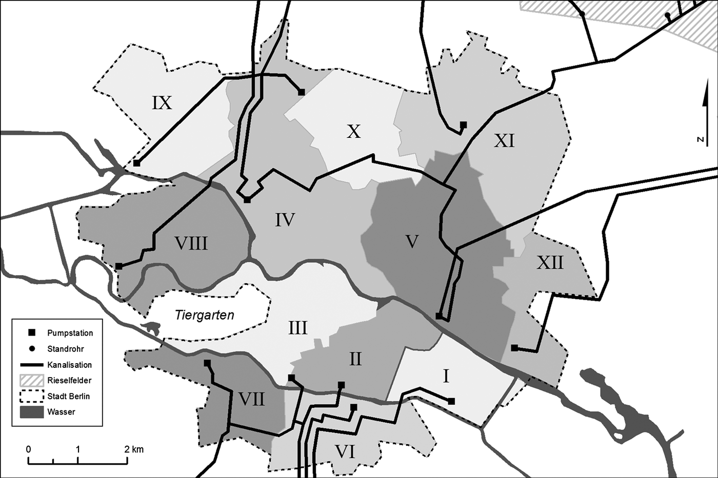
James Hobrecht, who knew the geography and geology of Berlin perhaps better than anyone else, and who had overseen the construction of a sewage system in Stettin, enthusiastically endorsed the proposed sewage farms. He became director of the massive project. Construction began in 1873 and continued into the twentieth century. Hobrecht, Virchow, and their colleagues were enormously proud not only of the sewage fields, but also of a second major innovation over other systems that they had studied: its “radial” design. They divided the city into twelve districts and in each created an independent underground canal network that led to its own sewage field outside the peripheries of the city. The independent operation of the twelve districts ensured that if there were a stoppage or a breakdown in one segment, the other eleven would not be affected. Each was designed for its own particular soil conditions and population density. The twelve different receiving fields dispersed the water over the widest possible area to avoid problems such as those in Paris, which sent its sewage to four fields in relatively close proximity to one another. The sewer canals were constructed under the streets. The canals had an egg-shaped profile, which had proven in other cities to be the best way to concentrate the flow. They were lined with glazed clay pipe so as to avoid seepage into the groundwater. Every connected building had a drainpipe flowing into the sewer under its street. The underground flow was not forceful enough to carry all of the solid matter with it, so workers had to clean the tunnels periodically, by walking through them and pushing the debris ahead. This unpleasant and labor-intensive practice was later replaced by mechanical devices. The canals led to pumping stations with powerful steam engines, which forced the drainage toward the end goal, the sewage farms. On each farm there was a complex series of vertical holding tanks (Standrohre), weirs, filters, settling ponds, and seepage fields. The city was furiously purchasing agricultural lands. Within ten years, 1.5 million Berliners lived in dwellings connected to the system, which was pumping forty-two million cubic meters of water a year. By 1893 the city of Berlin had 584 kilometers of pipes leading to 144 kilometers of underground canals. The project created a huge bureaucracy of managers, engineers, office workers, scientists, and laborers to run and maintain the system—a total of 1,066 people by 1919. By 1923, Berlin possessed thirty-six agricultural properties totaling 25,255 hectares, of which 10,708 hectares were used directly as sewage fields. In addition to the mass of employees who worked on the system in the city, 1,901 men and women worked as managers and laborers on the “city farms” (Stadtgüter), that is, the sewage fields and related farm lands (see Image 1).Footnote 24
Berlin's Radial Sewage System with twelve independent districts. Digitally created, based on Landesarchiv Berlin, F Rep. 270, A_615.

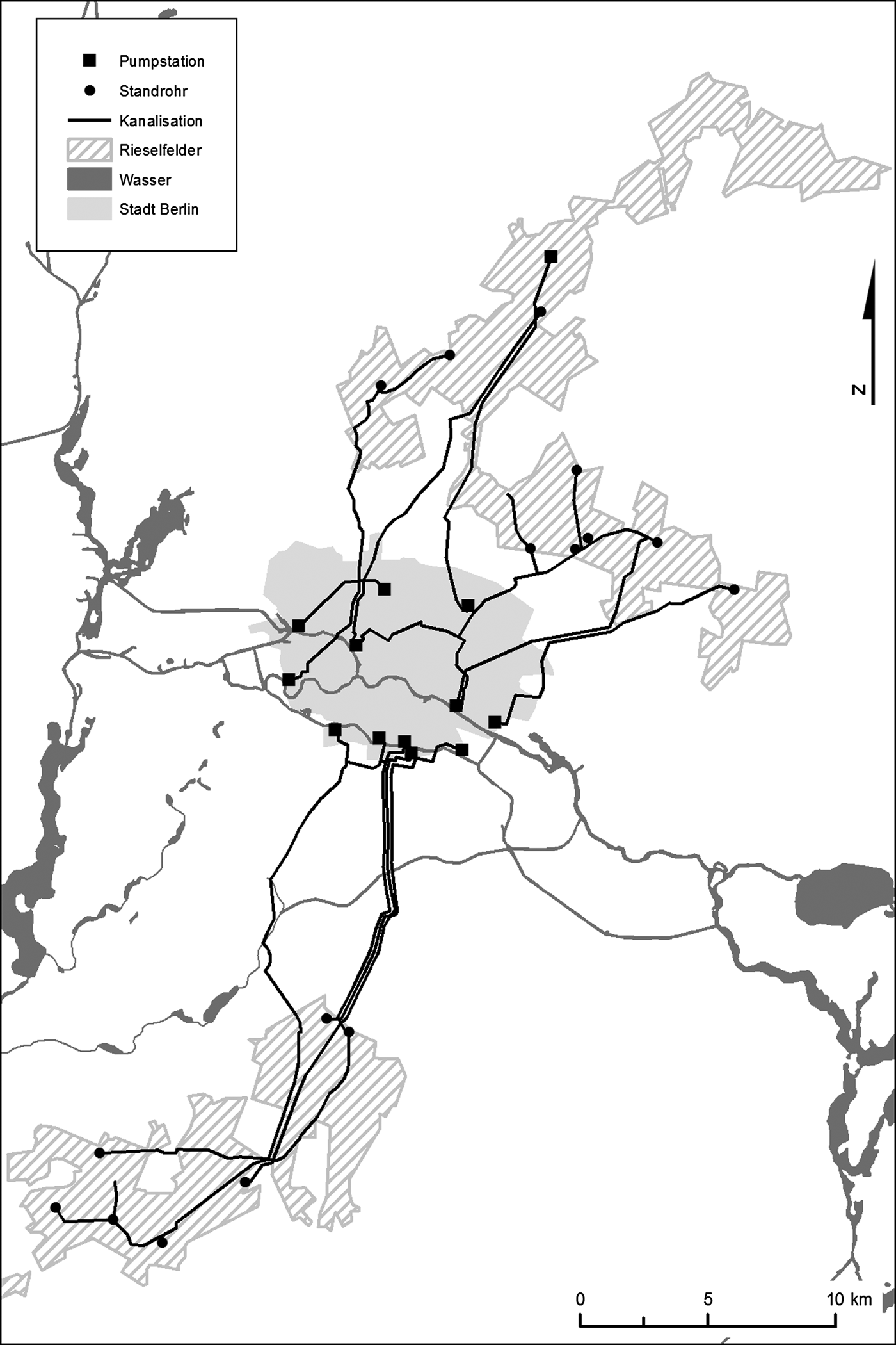
Berlin had increasingly distanced itself from agriculture during the nineteenth century as it developed into an industrial metropolis. Now, driven by fear of disease and new sensibilities about waste and sanitation; informed by changing scientific understandings of soil, water, and infection; and inspired by new theories of plant cultivation, industrial Berlin had reached out far beyond its boundaries to colonize huge expanses of the agrarian landscape. All of this was done with the optimism that the massive engineering project would enable the modernization of an ancient practice—recycling organic waste—to serve the dual goals of improving life in the city and enhancing agricultural production (see Image 2).
Properties purchased as sewage farms outside the boundaries of Berlin. Digitally created, based on Landesarchiv Berlin, F Rep. 270, A_615.
Berlin's Suburbs: The Case of Steglitz
To pump its sewage out to its new seepage fields, in some cases as far as thirty kilometers from the city, Berlin's engineers excavated giant tunnels through a ring of residential, commercial, and farming communities that surrounded the city limits. This included two incorporated cities—Spandau and Charlottenburg—and approximately eighty villages, many of which were fast assuming urban characteristics by serving as Berlin suburbs and thus relieving some of the population pressure of the urban core. The capital's relationship with its surrounding neighbors had a long history and was changing fast. Having earlier given up its medieval fortification that had enclosed the small river settlements, Berlin and Cölln, Berlin surrounded itself in 1737 with a gated customs wall that controlled the traffic into and out of the urban boundaries and enabled the collection of excise taxes. Both the courts and the police, however, extended their jurisdiction beyond the customs wall, especially the latter, who claimed the right to enforce order in a territory that sometimes reached as far as ten kilometers beyond Berlin's limits. The wall provided a sentry point to watch over the perceived unruly suburbs, suspected of harboring social unrest, crime, and prostitution. The police made periodic raids into the suburbs to apprehend alleged criminals, revolutionaries, and other troublemakers. The attitudes behind these activities defined Berlin's urban frontier as strange and possibly threatening.Footnote 25
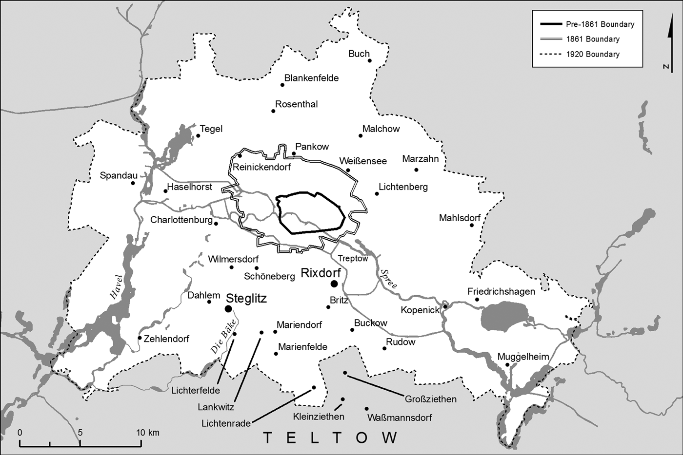
With the population explosion of the early and mid-nineteenth century and with the new industrial capitalism dependent upon commerce and geared to expansion, Berlin authorities began to look differently at the surrounding neighborhoods. The 1860s demolition of the customs wall and gates and incorporation of several adjacent communities signified a shift in attitude. The communities beyond the new, open city boundaries began to look less like a threat and more like resources to be exploited. Berlin authorities began to understand it as natural that Berlin would extend not only its sewer lines, but also its commercial and political dominion outward into the surrounding area. As planners considered Berlin's growth, the villages seemed more inviting than menacing. There were competing voices, however. Conservative forces, including many in the Prussian government, opposed territorial expansion of the capital city, in part fearing that a larger Berlin would strengthen the already powerful Social Democratic representation in the Reichstag (see Image 3).Footnote 26
Berlin's changing borders, with emphasis on the locations discussed in this article. Created by J. Glatz and the Western Michigan University Libraries Mapping Service on the basis of data obtained from HGIS Germany (http://www.hgis-germany/de).
Meanwhile many of the suburban communities grew at astounding paces, sometimes doubling their populations in a decade's time. Land developers found great profits in purchasing former agricultural lands to subdivide them and construct new housing. The farmers were free to sell their properties, thanks to the previous agrarian reforms, and many were eager to take advantage of a new form of wealth. Village governments, only recently having presided over agricultural activities, had few building codes in place, so the development corporations often had free hand in the type of structures and street designs they constructed. Some of the villages, often those that already had a history of preindustrial crafts and artisanship, developed into suburban working-class neighborhoods with “rental barracks.” Others, including several south of the city, developed into “villa colonies” where well-to-do Berliners established luxurious residences on spacious lots, from which the heads of households could commute to the city while their families enjoyed the “country” atmosphere of clean air and wide streets. Some moved their businesses to the suburbs, while still enjoying the commercial advantages of proximity to the industrial city. Between 1861 and 1900 the communities outside the city limits grew at a pace three times that of Berlin proper.
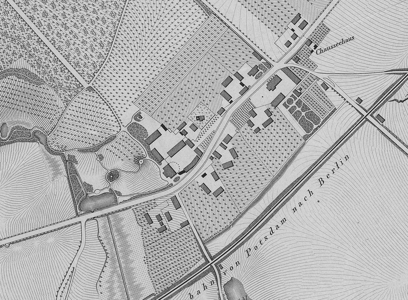
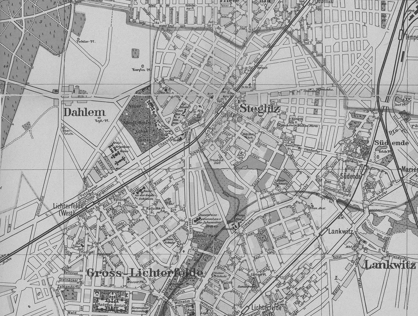
One of those villages was Steglitz, situated ten kilometers southeast of the old city center of Berlin until the 1861 city expansion, but afterward only five kilometers from the new city boundary. One of the approximately 2,000 villages established in the twelfth and thirteenth centuries by the Askanians, Steglitz remained a typical, very small, community of only seven households of hereditary peasants and cottagers, an inn, a church, an aristocratic estate house, and twelve laborers and servants until the beginning of the nineteenth century. Its inhabitants lived under the typical semifeudal conditions of Brandenburg. The peasants and cottagers held permanent contracts to cultivate the common fields, and they paid taxes in kind, as a portion of harvests. Some were required to render unpaid labor to the estate owner. Steglitz's agrarian reforms, however, were put in place very early and transformed communal lands into private real estate that could be commoditized and developed. Karl Friedrich Beyme purchased the village in 1801, as the first nonaristocratic owner. He was a high Prussian civil servant, soon to become a member of the Stein Reform Ministry of Prussia. In 1806 Beyme implemented his own experimental land reform a year before the famous Prussian agrarian reform edict of 1807. Although many details of the transformation of the peasants and cottagers' common lands into private real estate did not get finally worked out until the 1840s, Beyme's innovations established the path for a future land market. Several other factors coalesced to create potential for Steglitz's growth. Transportation conditions, for example, were favorable. The King's Highway, between Berlin and the Hohenzollern summer palace of Potsdam, one of the first paved roads in Prussia, passed directly through the village. In 1838 one of Prussia's first railroads followed this path through Steglitz. The Schröder family, one of the former semifeudal households, sold parcels of its property to the railroad, foreshadowing the transformation of the community from an agricultural to an urbanizing, commercial economy (see Image 4).Footnote 27
Steglitz, 1839, showing the seven peasant and cottager households, the estate house, the Berlin-Potsdam Chaussée, and the newly created railroad. Cropped from Landesarchiv Berlin, F Rep. 270, A_8803.
By mid-century, affluent middle-class families who sought refuge from the grime of industrializing Berlin were beginning to consider Steglitz an ideal location for suburban living, although not all of the new inhabitants were wealthy. After Beyme's daughter sold the estate portion of the agricultural lands in 1841, real estate developers subdivided cropland, woods, pastures, and meadows as the “colony” Neu-Steglitz in 1848.Footnote 28 (The common expression Kolonie in this context simply means new settlement; however, it also connotes the implications associated with empty land and frontiers.)
Between 1840 and 1845, entrepreneur Johann Adolph Heese purchased parcels totaling seventy-six Morgen of land (forty-seven acres), on which he planted 35,000 mulberry trees, perpetuating for a time a semi-agricultural character in the changing village culture, although one with an exotic crop cultivated according to practices not previously known in the village and grown for an industrial purpose. When the trees began to produce a few years later, Heese erected a large building near the center of the old village, to house both his silk mill and apartments for the mill hands, mostly women and children. The enterprise was Steglitz's largest industrial establishment until 1889 when Pébrine, a fungus-induced blight, spread across Europe, infected the silkworms, and destroyed his business. By this time, however, Steglitz had completely transformed itself. A second “colony,” Südende, developed on Steglitz's southeastern border. Under the ownership of a land development company (Aktien-Terraingesellschaft Südende), it erected prestigious “country villas” during the 1870s, and the settlement ballooned after 1875 when a new railroad that ran between Berlin and Dresden was constructed with a station in Südende. A second neighborhood of expensive villas was created on the subdivided “Fichtenberg” (Spruce Hill) beginning in the 1870s. In 1869 Steglitz got its own main train station, and in 1888 a streetcar line (see Image 5).Footnote 29
Steglitz in the 1890s. The Teltow Canal, flowing through Lankwitz, Steglitz, and Lichterfelde in the southeast corner of map, was drawn in after the canal was completed in 1906. Cropped from Landesarchiv Berlin, F Rep. 270, A_1523.
Steglitz's building boom was further stimulated by the population growth of adjacent communities. In 1865 wealthy Hamburg entrepreneur Johann Anton Wilhelm von Carstenn purchased two villages, Lichterfelde and Giesendorf, both of which bordered on Steglitz, to build a prestigious residential district for well-to-do Berliners who sought escape from the city. Carstenn systematically planned his new development, Groß-Lichterfelde, with wide streets, large lots, green spaces, and luxurious restaurants. In 1871 he donated the land for the Prussian military officer-training academy, the Hauptkadettenanstalt, in Groß-Lichterfelde, further enhancing the reputation of the community. In 1881, Groß-Lichterfelde again came into the spotlight with an innovation in streetcars. Horse-drawn streetcars had come into widespread use in the 1850s, changing people's relationship with their environments. For the first time those not wealthy enough to own or hire a horse or coach could travel to other parts of their environs without walking. The firm of Siemens und Halske constructed the first electric streetcar in the world in Groß-Lichterfelde, running between the Hauptkadettenanstalt and the train station. Although Carstenn later encountered financial difficulties that ended in personal bankruptcy, the building boom that he fostered in the luxurious neighborhood Groß-Lichterfelde stamped a character on Berlin's southern suburbs and stimulated growth in neighboring Steglitz.Footnote 30
During the three decades 1855 to 1885 Steglitz's population had exploded, increasing by a factor of thirteen, rising from 648 inhabitants to 8,460. In comparison, during the same period, Berlin's numbers had tripled. If the big city was experiencing waste and sanitation problems, certainly the teeming village was overwhelmed. Like any other early industrial community, Steglitz also had its share of animals that dropped manure on streets and in courtyards: 165 horses, 77 cattle, 148 pigs, and 302 goats in 1883. Steglitz, although growing faster, was not as densely populated as Berlin, largely because of the relative affluence of the inhabitants. In the community's published statistics, it boasted an average of twenty-five inhabitants per property in 1911, compared to Berlin's seventy-seven.Footnote 31 Nevertheless, there were the typical drainage problems. The soil that had only recently supported grain fields, meadows, pastures, and woods, was now increasingly covered with paving stones and buildings, which negated its absorption capacity. Whereas precipitation had been a life-sustaining phenomenon a few generations earlier, it was now a problem to be solved. Runoff from storm water and the waste from dwellings and businesses were acute concerns by 1885, and officials knew that the problems would only become more severe as they watched their population more than double every ten years. Steglitz was not experiencing the epidemic diseases that had been a catalyst for Berlin's sewage system, but middle-class sensibilities and the increasing scientific understanding of disease drove the village magistrates to seek a solution. Many of Steglitz's well-to-do residents had left Berlin to avoid the filth of the city, and they did not wish to experience the same in their new community.
With practically no agricultural fields remaining on which to recycle the contents of cesspools and outhouses, Steglitz employed a contractor to haul them in sealed containers to other villages. A main destination was neighboring Dahlem, the lands of which were still in full agricultural use in the form of a state domain. Dahlem had belonged to Beyme, and when his daughter sold the property at the same time that she sold Steglitz, it became a royal Prussian agricultural estate. For a few years thereafter, until the state could set up a managerial system, Steglitz farmers were allowed to cultivate some of Dahlem's fields. By 1846 it was under the supervision of an administrator, appointed by the Prussian government. The domain managed typical grain and animal operations, and at one time it boasted a herd of more than 2,000 sheep. In 1885 the estate had only 145 inhabitants. But even Dahlem's 491 hectares (1,227 acres) could not absorb the human waste from a community of 8,500 people.Footnote 32
Steglitz's magistrates invited experts to inform them of possible modern means of disposing of household waste. The community took the first step by obtaining running water, obtained through a contract with the Charlottenburg Waterworks Company in 1885. After considering several alternatives, the magistrates resolved to construct their own underground canal system similar to Berlin's. Village leaders set about seeking a property farther away to serve as a sewage farm, and in 1892 the village government purchased the aristocratic estate Klein Ziethen from the owner, Wilhelm Keller, for 814,400 marks, as a destination for its unwanted human excrement.Footnote 33 Joining Berlin and a number of other growing suburbs, Steglitz determined to employ science and engineering to turn a foul and unwanted substance into an asset. Steglitz would enrich the soil of the green meadows of Klein Ziethen and enhance agriculture.
The construction of Steglitz's sewage system was part of a larger, developing network. It incorporated one important innovation over Berlin's: instead of draining both household water and rainwater into the same channels, Steglitz became the first community in Europe to separate the two, thus avoiding the flooding of the system and overflow of sewage during heavy rainfall. Working under the assumption that the rainwater did not need treatment, the planners reasoned that the filtering configuration could be less extensive if the street runoff were excluded. The community continued to allow the water from precipitation to stream downhill into the small river, Bäke—later transformed into the Teltow Canal—which flowed into the Havel, later the Elbe, and eventually the North Sea.Footnote 34 Only some years later did it become clear that water flowing from urban streets and alleys contained chemical, biological, and heavy metal contaminants that cause environmental problems.
To manage the sewage, Steglitz constructed and placed its own small version of the massive Berlin underground channels and sewage farms into operation by 1895. The installation began with pipes that led to a walled storage tank at the lowest point of the village property. The waste flowed into it by gravity, and after it passed over a “sand filter,” a pumping station with powerful steam engines sent it through an 11.5-kilometer pressurized subterranean canal to the new property, Klein Ziethen. The canal that carried Steglitz's sewage surged under three neighboring communities, Lankwitz, Marienfelde, and Lichtenrade, before reaching its destination (see Image 3). When the pressurized liquid reached Klein Ziethen, it emptied from the pumping pipe into one section of a four-compartment settlement basin surrounded by a meadow. It was here that the bulk of the solid waste settled out. When one unit was full, workers directed the water to the next and shoveled the settled “slime” (Schlicke), onto fields to dry. They then spread it as fertilizer on the fields and meadows of the estate, and they sold some to other agriculturists.Footnote 35
It had long been demonstrated that Virchow's optimistic 1873 prediction that the sandy soil would absorb all of the water was incorrect. All of the sewage fields had to be equipped with drains to remove the water that emerged after being filtered through the earth. In Klein Ziethen, excess liquid flowed through underground distribution pipes of decreasing size until it reached an opening on the surface from whence it emptied into a series of ditches, regulated by a sequence of wooden gates. The sandy-bottom ditches allowed water to sink again into the soil, but here also, the ground could not soak it all up, and the excess then flowed into a 2.7-kilometer-long ditch, where it mingled with the outflow of the sewage farm Waßmannsdorf, owned by Rixdorf, and into a two-part earthen fish pond, stocked with carp. Finally, the outflow from the carp ponds was recaptured in pipes and redirected into the Bäke River. The Teltow Canal, constructed in 1906 in large part as a drain system for rainwater runoff from the streets, subsumed the Bäke entirely. So in a continuation of the challenge of urban liquids that had not been satisfactorily resolved in the 1890s, the Teltow Canal became the destination of the community's storm runoff and water left from filtered sewage.Footnote 36
Rixdorf, owner of the Waßmannsdorf sewage field that neighbored Klein Ziethen, was, in contrast to Steglitz, a working-class suburb. It had a long history as an artisan community of weavers, and it had grown explosively since mid-century, as clothing and textiles became more industrialized. In 1899, it achieved the status of an independent city, renamed Neukölln. Ten years previously, in 1889, the community had begun to construct its sewer system, which was completed by 1893. The confluence of the urban waste products of Steglitz and Waßmannsdorf intertwined the two growing communities in mounting negotiations with one another. The systems that the two suburbs created had made sewage and its byproducts a Greater Berlin issue.Footnote 37
In 1905 a community journalist who surveyed the seepage fields in Teltow County, of which both Klein Ziethen and Steglitz were a part, maintained that the settlement and filtering processes of the newly transformed properties yielded “water so clear that it cannot be distinguished from other water; there could be no fear of endangering oneself by drinking it.” This optimistic assessment by a nonscientist, generally shared by the planners and early observers of the entire ring of sewage farms around Berlin, was scientifically tested beginning some years later, when the Prussian government established the Royal State Bureau for Water Hygiene, located in Dahlem. This laboratory conducted semiannual analyses of the quality of Berlin's waters. Steglitz, along with every other community that emitted substances into a public waterway, was mandated to pay for their part of the testing. Steglitz's bill was ninety marks for each semiannual inspection.Footnote 38
The agency reported in 1914, taking samples and analyzing the water at multiple stations of Steglitz's system, starting at the first collection tank and proceeding into the sewage field ditches, the fish ponds, and finally the Teltow Canal. Bacterial, fungal, and other organic materials, along with metals, chemicals, other mineral compounds, and detritus were present in material flowing through the pumping station and in ever decreasing amounts following each stage of sedimentation or filtration. The scientists found that the samples taken in the carp pond and in the Teltow Canal, fifty meters below the outflow pipe, were “acceptable,” even though they listed three primary contaminants (oscillatoria, synedra ulna, and spirogyra crassa) and more than a dozen others that were identified in individual instances. Within the Teltow Canal they isolated substances such as coal, cloth fibers, and detritus, along with “more isolated” examples of biological and mineral substances. Subsequent semiannual reports through 1917 yielded similar results. The scientists did find artificially low oxygen levels in the water and increased temperatures, resulting in fish kills. But they attributed these to heating plants on the canal, not the sewage farms.Footnote 39
The semiannual scientific reports were recorded in large thirty-column tables that documented the time and location of sampling, the air and water temperatures, the appearance of the water, and its chemical and physical analysis. In the first years, the tables were created by hand, with pen and ruler; by 1916, the forms had been printed, with the data to be entered when the analyses were complete. The teams consisted typically of two scientists and one engineer. The large, expensive, and permanent technical bureaucracy created to conduct these and other examinations suggests that Berlin officials were aware of the potential they had created to alter the region's aquatic environment negatively. All of Berlin's waterways were being analyzed, not just those below the sewage fields. The summary reports, while composed in scientific terminology, suggest that the experts were pleased to render largely affirmative evaluation of the waters flowing from Klein Ziethen and other sewage farms.
Thus Steglitz underwent a major transition in just over two decades. Until 1885 it had recycled its human waste in agriculture by depositing it on a neighboring community's land. Ten years later it managed an extensive infrastructure and had its results monitored by a team of scientists employed by a state agency. Itself a progressively interesting object of control or acquisition by the growing metropolis, Steglitz pursued an increasingly ambivalent stance between maintaining independence and becoming a colony of Berlin. Meanwhile, it was pulled into the culture of reaching out to the green pastures and colonizing its own properties.
Sewage was not the only realm in which Steglitz and other communities became entwined in the affairs of Greater Berlin. The Prussian government had been trying to impose some order on the rash building process going on in the suburbs of Berlin since the late 1860s. In 1868, 1872, and 1887, it established building codes similar to Berlin's that applied to both city and countryside. Thus Steglitz and its entrepreneurs lost the free hand of laissez-faire that they had enjoyed in the first construction boom. As Berlin's reach continued to expand into the surrounding communities, confusion developed about lines of authority and coordination of urban-type services. Steglitz's political and community leaders sought to gain more control over their own affairs by petitioning to become a self-standing city, rather than a village. That this was a distinct possibility is illustrated by the fact that four of Steglitz's neighbors achieved the goal: Schöneberg (1898), Rixdorf (1899, renamed Neukölln in 1912), Wilmersdorf (1907), and Lichtenberg (1907). Steglitz petitioned no less than seven times over the course of ten years (1903–13) to gain the status and rights of a municipality, all of which were rejected. The Prussian provincial government, the city of Berlin, and above all, the Kreisregierung of Teltow all opposed the power and independence that this would bring to the expanding and urbanizing community. The powerful Landrat of Teltow, Ernst von Stubenrauch, was especially adamant because of the “amputation” of Schöneberg, Rixdorf, and Wilmersdorf from his county when they became cities.Footnote 40
While campaigning to establish its autonomy as a city, Steglitz nevertheless moved a symbolic step closer to Berlin by changing its official name to Berlin-Steglitz in 1912. In a controversial project initiated in 1909 by Wilmersdorf, Steglitz's neighbor to the north, three cities, twenty-six villages, and one estate each appended “Berlin” to their names, forming “nominal Greater Berlin.” (Only the two largest of the suburban communities, Charlottenburg and Neukölln, declined to enter this alliance.) Steglitz's governing council was initially reluctant to join and rejected the proposal. It later consented, having been convinced by the mayor that the enhanced name recognition of Berlin-Steglitz would be advantageous for businesses. The new nomenclature effected no change in governmental authority or structure, but it portended changes soon to come.Footnote 41
The complex group of governmental authorities in the Berlin region, however, found themselves badly in need of a means of coordinating citizen services and regulatory powers. In addition to sixty sewage systems, there were fifteen different public transportation companies and forty-three gas and electric works, often inefficiently duplicating each other's work and sometimes working at cross-purposes. Thus in the same year as the name changes, Berlin, five other cities, and the Landkreise Teltow and Niederbarnum established the Zweckverband Groß-Berlin. Among its many activities relating to schools, hospitals, postal services, and judicial affairs, it concentrated on three major objectives: synchronization of the transportation systems, regulation of building codes, and acquisition and preservation of green spaces, including parks, forests, lakes, playgrounds, and sports fields. As Berlin reached out, its smaller neighbors found it in their interest to work within the concept of “Greater Berlin.”Footnote 42
The Green Meadows of Klein Ziethen
Steglitz's newly acquired estate of Klein Ziethen had a land area almost the size of Steglitz itself. It encompassed 522 hectares (1,2901 acres) as compared to Steglitz's 577 hectares (1,426 acres). As was true of all of the sewage farms, only a portion of Klein Ziethen was used for the actual seepage fields. Of the estate's land, originally forty-five hectares (111 acres) were converted for this purpose. By 1928 this had been expanded to 108 hectares (267 acres); another sixteen hectares (39.5 acres) were taken up with roads and ditches necessary for the operations to work. This left 398 hectares (983 acres) of “natural land” to be operated as a farming enterprise. The Village of Steglitz thus became an agricultural proprietor, an engagement from which its citizens had recently distanced themselves as the community had become urbanized. Reaching into the rural world, Steglitz even had to assume the payment of still existing semifeudal tithes to the village church and to the sexton of Klein Ziethen. Tithes were due on St. Martin's Day, the traditional day of reckoning for peasants. The monetary payments were expressed in measures of grain and other agricultural crops. Steglitz would pay the cash price for a determined number of liters of grain, according to the current prices on Berlin markets. The Klein Ziethen church sexton received, in addition to the cash equivalent of the grain allocation, the value of seventy-four eggs per year. To work the land, Steglitz authorities recruited a team of managers and farm workers, the latter including both tenant farmers and day laborers. The former received housing, wages, and a portion of the harvested crops. Some of the wageworkers were Polish migrants, and some were Polish-speaking workers from Silesia.Footnote 43
The filtered and dried sewage may have been “excellent fertilizer,” but the new managers of Klein Ziethen knew from the experience of the earlier established sewage farms that the predicted giant turnips and cabbages had never materialized and would not do so on this property. And despite the use of the residue from the seepage basins, the operation was purchasing 6,000 marks' worth of chemical fertilizers a year. In its cultivated fields, the farm raised potatoes, beets, rye, and oats, much of which was consumed by the workers on the farm, rather than sold at market. This may be because much of the land was not suitable for abundant production of these traditional crops, for, as reported elsewhere, some of the land of the Rieselfelder properties was too water-soaked for these field and root crops. Grasses, on the other hand, flourished and could be mowed six times a year, so this became a lucrative product. Klein Ziethen proprietors decided to take advantage of the grass for animal fodder and invested in a commercial dairy production. They constructed a huge dairy barn and purchased a herd of 100 cows, which produced 1,100 liters of milk a day in 1909, also sold in the city, giving it a reputation as an economic success after the initial years of recouping a large capital outlay to get the operation going. The dairy was the greatest earner for Klein Ziethen, but the operation also sold, depending on the year, cattle, grain, potatoes, garden products, wood, straw and grass, beets, and stones. The estate constructed seven new apartment dwellings with space for twenty-five families, the workers on the agricultural operations. In addition it built a barrack in which twenty migrant or temporary workers, the grass cutters, could sleep. Between 1895 and 1908 the estate earned profits that ranged annually from 10,000 to 63,000 marks.Footnote 44
Steglitz's own reports of the farm operations depict a successful enterprise. It is likely that not everything worked smoothly, however. There were reports in general of the sewage field properties becoming “over-fertilized,” causing plants to die. And after some years, the buildup of the sediment spread onto the fields formed a hard crust on top of the soil, hindering the sprouting of grass and crops. The many dams, ditches, and underground pipes made it a challenge to work the fields with the newest technology. Workers sometimes had to harvest the grass using the traditional hand scythe.Footnote 45
Beginning in 1906, Klein Ziethen began to experience serious hydraulic problems. By 1908, cellars of the buildings on the farm began to flood. Thus it was that Frau Treppens turned to the authorities of Steglitz for redress of her water-damaged property. Steglitz contracted with an engineering firm to inspect the property and recommend a solution. The contractor bored thirty-one holes at strategic points of the Klein Ziethen terrain and found that the water table had risen seventy centimeters (twenty-eight inches), but his conclusions about the cause of the problem were ambiguous. Evidence pointed to the neighboring sewage farm, Waßmannsdorf, owned by Rixdorf. Yet Klein Ziethen's own drainage was not without problems. The contractors reported that there had been flooding in recent years on the boundary between Klein Ziethen and the community of Lichtenrad. “It is certain that the Ziethen drainage waters [alone] cannot have caused this sudden, abnormal change in the water table—seventy centimeters difference—even though one must admit that Steglitz is pumping increasing amounts of water [into the operation],” the inspectors reported. “There is no other source for the water than the flow from Rixdorf.” The contractor proposed to send the water samples to the government testing laboratory, which would determine the biological content, presumably to provide further proof that Rixdorf was the responsible party. Rixdorf's seepage field had had problems from the beginning because of Waßmanndorf's relatively clay-rich soil. The consultants warned Steglitz magistrates of the possibility that this water was, indeed, coming from Klein Ziethen, and there could be liability for this.Footnote 46
Years of meetings between the authorities of Steglitz and those of Rixdorf-Neukölln ensued, with each consulting with their respective engineers and other experts. Without seeming to name a guilty party, the participants reached the conclusion that a massive drain had to be excavated to address the flooding problem. Steglitz authorities appropriated 31,500 marks for the project in December 1908, but during the next two years had to increase the appropriation to a total of 83,000 marks. By 1912 they had dug a canal through the community of Rudow to enable the excess water to flow into the six-year-old Teltow Canal. The flooding problems continued for the next decade, ultimately costing the community 285,000 marks by 1919, and the problem had not been satisfactorily addressed.Footnote 47
Setting out to solve their challenge of household sewage in 1885, the authorities of Steglitz endorsed a scientifically modern and environmentally optimistic plan that would remove the waste from their own surroundings while enhancing agricultural lands just beyond the built-up suburban areas. They created a large infrastructure, developed a sizeable bureaucracy, made themselves the proprietors of an agricultural property, transformed its ecology, and incurred the obligation permanently to engage in scientific analysis of their results. Their drainage problems on Klein Ziethen became a major focus of community energy and resources. The environmental and structural issues in the years before and during World War I took on a life of their own. The archival documents dealing with these issues reveal a community so preoccupied with its sewage and drainage problems that Germany's international war seemed far on the horizon. Steglitz authorities appear to have been more concerned with keeping Frau Treppens's Gasthaus from being further damaged and restoring their dairy and grass-producing operations to viability than with a war.
The end of World War I precipitated the climax of many processes that had been long in coming. Among them was Berlin's 1920 annexation of the approximately eighty rural communities and cities that surrounded the densely inhabited imperial city, including Steglitz. In the establishment of the expanded metropolitan government, villages were combined with one another into larger districts. Steglitz and two neighbors, Groß-Lichterfelde and Lankwitz, combined to become a single urban administrative district of Berlin; Steglitz's own colonized land, Klein Ziethen, like all of the seepage farms that belonged to suburban communities, became a property of Berlin. Perhaps the challenges of water contamination, water-table levels, flooding basements, and managing an agricultural estate contributed to Steglitz's willingness to accept annexation into Berlin and turn over their rural properties to the municipal government.
Conclusion
In the terrain that became modern, industrial Berlin, the alteration of the natural landscape created unforeseen problems for both the city and its expanding suburbs. This was because the traditional methods of removing waste—recycling and gravity-driven water flow—were no longer tenable in the densely populated industrial city. What had previously been a resource now became filth. Researchers and community leaders, using nineteenth-century scientific methodologies, postulated a connection between urban waste—especially human excrement—and infectious disease. Vigorously seeking solutions, they studied the steps other European cities had taken, and they analyzed Berlin's unique conditions, including soil, water, and public health conditions. The absorptive qualities of Brandenburg's sandy earth appeared to offer a great potential that would allow the modernization of an ancient practice of recycling human waste for agricultural gain. This led the planners to look toward the agrarian landscape, far beyond what would become the eventual boundaries of Greater Berlin, as a destination for the urban sewage. A rationale supported by the new, scientific agriculture supported the plans: sewage fields could be a way to capture the rich nitrogen and other nutritive elements that would enhance plant growth and, hence, agricultural production. Using state-of-the-art engineering techniques, Berlin created a massive subterranean and aboveground infrastructure to modernize the ancient practice of carrying night soil to the green fields. In this historical development, the new sewage system used fossil fuels to rid the city of its unwanted waste. Instead of allowing the glacially created gradations of the earth to determine the destination, humans created their own depositories for the city sewage. They used science to convince themselves that their urban waste could be a positive resource. This established the need for a massive bureaucracy to monitor and manage the system. The process altered the ecosystems of a ring of properties in the Brandenburg countryside, the effects of which would be experienced for far more than a century.
Berlin's expansion was not only related to sewage; it was also jurisdictional. As the communities of the periphery increasingly urbanized themselves as small “colonies” of Berlin, they became progressively entwined with the center. Former villages, Steglitz and Rixdorf among many others, reached into the green landscape to create their own sewage farms, based on Berlin's model. Finally, Berlin's expanding grasp incorporated them formally into the metropolis, culminating a process that had been underway since at least the 1860s. On October 1, 1920, Berlin became city of 3.8 million inhabitants within a perimeter of 883 square kilometers (341 square miles), making it, in area, the third largest city in the world after New York and London. It encompassed, in addition to the old Berlin, fifty-nine former “villages,” twenty-seven agricultural estates, and seven cities. (Between 1862 and 1920 five of the villages had achieved the status of cities, making the total seven.) Among the rural areas, there was significant forested land, affording the opportunity for the preservation of green space within the city proper. With only very minor exceptions, the 1920 city limits are those of today.